Embed Size (px)
Citation preview
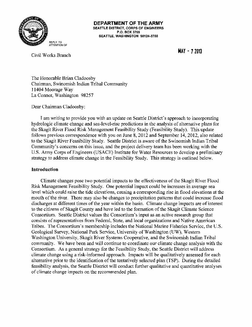
REPLY TO ATTENTION OF
Civil Works Branch
DEPARTMENT OF THE ARMY SEATTLE DISTRICT, CORPS OF ENGINEERS
P.O. BOX 3755 SEATTLE, WASHINGTON 98124-3755
The Honorable Brian Cladoosby Chairman, Swinomish Indian Tribal Community 11404 Moorage Way La Conner, Washington 98257
Dear Chairman Cladoosby:
t4AY - 7 2013
I am writing to provide you with an update on Seattle District's approach to incorporating hydrologic climate change and sea-level-rise predictions in the analysis of alternative plans for the Skagit River Flood Risk Management Feasibility Study (Feasibility Study). This update follows previous correspondence with you on June 8, 2012 and September 14, 2012, also related to the Skagit River Feasibility Study. Seattle District is aware of the Swinomish Indian Tribal Community's concerns on this issue, and the project delivery team has been working with the U.S. Army Corps of Engineers (USACE) Institute for Water Resources to develop a preliminary strategy to address climate change in the Feasibility Study. This strategy is outlined below.
Introduction
Climate changes pose two potential impacts to the effectiveness of the Skagit River Flood Risk Management Feasibility Study. One potential impact could be increases in average sea level which could raise the tide elevations, causing a corresponding rise in flood elevations at the mouth of the river. There may also be changes to precipitation patterns that could increase flood discharges at different times of the year within the basin. Climate change impacts are of interest to the citizens of Skagit County and have led to the formation of the Skagit Climate Science Consortium. Seattle District values the Consortium's input as an active research group that consists of representatives from Federal, State, and local organizations and Native American Tribes. The Consortium's membership includes the National Marine Fisheries Service, the U.S. Geological Survey, National Park Service, University of Washington (UW), Western Washington University, Skagit River Systems Cooperative, and the Swinomish Indian Tribal community. We have been and will continue to coordinate our climate change analysis with the Consortium. As a general strategy for the Feasibility Study, the Seattle District will address climate change using a risk-informed approach. Impacts will be qualitatively assessed for each alternative prior to the identification of the tentatively selected plan (TSP). During the detailed feasibility analysis, the Seattle District will conduct further qualitative and quantitative analyses of climate change impacts on the recommended plan.
-2-
Sea Level Rise
USACE has established procedures to address future sea level rise that are described in Engineering Circular (EC) 1165-2-212 which is enclosed for your reference. Seattle District will apply the EC 1165-2-212 guidance to the Skagit River Feasibility Study. The guidance calls for an evaluation of the potential hydraulic impacts of low, intermediate, and high sea level rises on both with- and without-project conditions.
There are numerous past and ongoing studies of sea level rise in the project area. Those studies have produced a wide range of future rises. The EC indicates the expected range of global sea level rise is 0.4 to 2.1 feet by 2063. We will examine recent sea-level-rise forecasts, including those by the UW and the 2012 National Academy of Sciences Committee on Sea Level Rise in California, Oregon, and Washington.
Hydrologic Changes
Nationally, the hydrologic impacts of climate change are likely to vary by region and the science is still evolving. Seattle District has been and continues to be supportive of research in this area. USACE has not yet established a procedure for addressing potential hydrologic changes caused by future climate change. The USACE Institute for Water Resources is working with other Federal agencies to address this issue. USACE's efforts on this subject were outlined in the "USACE Climate Change Adaptation Plan and Report 2011" dated 30 September 2011 and have been updated in the "USACE 2012 Climate Change Adaptation Plan and Report" dated June 2012. A key conclusion from both reports is the need to implement risk-informed decisionmaking for climate change. The 2012 plan calls for emphasis on the USACE mission areas of ecosystem restoration, flood risk management, and water management. The USACE 2012 Climate Change Adaptation Plan and Report is enclosed for your reference.
The Skagit Climate Science Consortium sponsored the 2011 "Skagit River Basin Climate Science Report". That report describes potential hydrologic changes that may occur in the Skagit Basin under a range of possible climate change scenarios. Key predictions in the report include reduced spring season snowpack, lower late summer/early fall streamflows, and increased flood peaks. The predicted flood peak increases ranged from 4 to 64 percent by 2040, with an average of 23 percent. By 2080, the predicted flood peak increases ranged from 0 to 98 percent, with an average increase of 40 percent.
As with sea level rise, Seattle District will take a phased approach to assessing the impacts of potential future hydrologic changes. A risk-based approach will be used in a qualitative evaluation of the sensitivity of our three alternatives to increased flood discharges and will be conducted prior to the identification of the TSP. During ongoing feasibility analysis, with- and without-project hydraulic modeling of the Skagit River will be conducted incorporating forecasted sea level rise and will include simulations using increased flood discharges. Those
-3-
analyses will utilize the results from the 2011 "Skagit River Basin Climate Science Report" or any updated forecasts that might become available. The Seattle District has already met with the report authors to ensure we properly understand their predicted climate change hydrologic forecasts. The simulations using increased flood discharges will provide information on how the recommended plan may be adapted to provide greater resiliency as hydrologic climate change impacts begin to be seen in the basin.
Study Coordination
Seattle District will continue to work with the USACE Institute for Water Resources--which regularly engages with other Federal agencies, including the Climate Change and Water Working Group--to insure we apply the best available and actionable science. We will also continue to collaborate with the Skagit Climate Science Consortium and/or UW to stay up to date on climate change hydrologic forecasts for the Pacific Northwest. We will employ riskinformed decisionmaking throughout the Feasibility Study, including decisions influenced by climate change. Our approach is consistent with the June 2011 USACE Climate Change Adaptation Policy Statement, which calls for integration of climate change adaptation planning and actions into USACE missions, operations, programs, and projects. A copy ofthis policy statement, signed by Ms. JoEllen-Darcy, Assistant Secretary of the Army for Civil Works, was provided in previous correspondence from September 14, 2012. Analysis of potential hydrologic changes caused by future climate change will be developed in coordination with our sponsor, Skagit County, and within the constraints of project schedule and funding.
Your comments, input, and scientific data will continue to be welcomed as the study moves forward. If you have any questions or desire additional information, please contact my Tribal Liaison, Ms. Lori Morris, at (206) 764-3625 or [email protected]. A copy of this letter is being sent to those individuals on the enclosed list.
Enclosures
Sincerely,
c o onel, Corps of Engineers
· District Commander

Copies Furnished: Honorable Patty Murray United States Senate 2930 Wetmore Avenue, Suite 903 Everett, Washington 98201 Honorable Patty Murray United States Senate 448 Russell Senate Office Building Washington, DC 20510 Honorable Maria Cantwell United States Senate 2930 Wetmore Avenue, Suite 9B Everett, Washington 98201 Honorable Maria Cantwell United States Senate 311 Hart Senate Office Building Washington, DC 20510 Honorable Rick Larsen Representative in Congress Wall Street Building 2930 Wetmore Avenue, Suite 9F Everett, Washington 98201 Honorable Rick Larsen House of Representatives 108 Cannon House Office Building Washington, DC 20515

DEPARTMENT OF THE ARMY EC 1165-2-212
U.S. Army Corps of Engineers
CECW-CE Washington, DC 20314-1000
Circular
No. 1165-2-212 1 October 2011
EXPIRES 30 September 2013
SEA-LEVEL CHANGE CONSIDERATIONS FOR
CIVIL WORKS PROGRAMS
1. Purpose. This circular provides United States Army Corps of Engineers (USACE) guidance
for incorporating the direct and indirect physical effects of projected future sea-level change
across the project life cycle in managing, planning, engineering, designing, constructing,
operating, and maintaining USACE projects and systems of projects. Recent climate research by
the Intergovernmental Panel on Climate Change (IPCC) predicts continued or accelerated global
warming for the 21st Century and possibly beyond, which will cause a continued or accelerated
rise in global mean sea-level. Impacts to coastal and estuarine zones caused by sea-level change
must be considered in all phases of Civil Works programs.
2. Applicability. This Circular applies to all USACE elements having Civil Works
responsibilities and is applicable to all USACE Civil Works activities. This guidance is effective
immediately, and supersedes all previous guidance on this subject. Districts and Divisions shall
inform CECW of any problems with implementing this guidance.
3. Distribution Statement. This publication is approved for public release; distribution is
unlimited.
4. References. Required and related references are at Appendix A. A glossary is included at the
end of this document.
5. Geographic Extent of Applicability.
a. USACE water resources management projects are planned, designed, constructed and
operated locally or regionally. For this reason, it is important to distinguish between global mean
sea level (GMSL) and local (or “relative”) mean sea level (MSL). At any location, changes in
local MSL reflect the integrated effects of GMSL change plus changes of regional geologic,
oceanographic, or atmospheric origin as described in Appendix B and the Glossary.
b. Potential relative sea-level change must be considered in every USACE coastal activity as
far inland as the extent of estimated tidal influence. Fluvial studies (such as flood studies) that
include backwater profiling should also include potential relative sea-level change in the starting
water surface elevation for such profiles, where appropriate. The base level of potential relative
sea-level change is considered the historically recorded changes for the study site. Areas already

EC 1165-2-212
1 Oct 11
2
experiencing relative sea-level change or where changes are predicted should analyze this as part
of the study. The project vertical datum must be current or updated to NAVD88 to be held as
constant for tide station comparisons and a project datum diagram must be prepared per EM
1110-2-6056.
6. Incorporating Future Sea-Level Change Projections into Planning, Engineering Design,
Construction, and Operating and Maintaining Projects.
a. Planning, engineering, designing, operating, and maintaining for sea level change must
consider how sensitive and adaptable 1) natural and managed ecosystems and 2) human and
engineered systems are to climate change and other related global changes. To this end,
consider the following two documents:
(1) The Climate Change Science Program (CCSP) Synthesis and Assessment Product 4.1
(SAP 4.1) Coastal Sensitivity to Sea-Level Rise: A Focus on the Mid-Atlantic Region details both
how sea-level change affects coastal environments and what needs to be addressed to protect the
environment and sustain economic growth. SAP 4.1 represents the most current knowledge on
regional implications of rising sea levels and possible adaptive responses.
(2) The National Research Council’s 1987 report Responding to Changes in Sea Level:
Engineering Implications recommends a multiple scenario approach to deal with key
uncertainties for which no reliable or credible probabilities can be obtained. In the context of
USACE project life cycle, multiple scenarios address uncertainty and help us develop better risk-
informed alternatives.
b. Planning studies and engineering designs over the project life cycle, for both existing and
proposed projects consider alternatives that are formulated and evaluated for the entire range of
possible future rates of sea-level change (SLC), represented here by three scenarios of “low,”
“intermediate,” and “high” sea-level change. These alternatives will include structural and
nonstructural solutions, or a combination of both. Evaluate alternatives using “low,”
“intermediate,” and “high” rates of future SLC for both “with” and “without” project conditions.
Use the historic rate of SLC (as described in Appendix B) as the “low” rate. Base “intermediate”
and “high” rates on the following:
(1) Estimate the “intermediate” rate of local mean sea-level change using the modified NRC
Curve I and equations 2 and 3 in Appendix B (see Figure B-13) and add those to the local rate of
vertical land movement as discussed in Appendix B.
(2) Estimate the “high” rate of local mean sea-level change using the modified NRC Curve
III and equations 2 and 3 in Appendix B (see Figure B-13) and add those to the local rate of
vertical land movement as discussed in Appendix B. This “high” rate exceeds the upper bounds
of IPCC estimates from both 2001 and 2007 to accommodate potential rapid loss of ice from

EC 1165-2-212
1 Oct 11
3
Antarctica and Greenland, but is within the range of peer-reviewed articles released since that
time (see Figure B-10).
c. Determine how sensitive alternative plans and designs are to these rates of future local
mean SLC, how this sensitivity affects calculated risk, and what design or operations and
maintenance measures should be implemented to minimize adverse consequences while
maximizing beneficial effects. Following the approach described in 6b above, alternative plans
and designs are formulated and evaluated for three SLC possible futures. Alternatives are then
compared to each other and an alternative is selected for recommendation. The approach to
formulation, comparison and selection should be tailored to each situation. The performance
should be evaluated in terms of human health and safety, economic costs and benefits,
environmental impacts, and other social effects. There are multiple ways to proceed at the
comparison and selection steps. Possible approaches include:
(1) Working within a single scenario and identifying the preferred alternative under that
scenario. That alternative’s performance would then be evaluated under the other scenarios to
determine its overall potential performance. This approach may be most appropriate when local
conditions and plan performance are not highly sensitive to the rate of SLC.
(2) Comparing all alternatives against all scenarios rather than determining a “best”
alternative under any specific future scenario. This approach avoids focusing on an alternative
that is only best under a specific SLC scenario and prevents rejecting alternatives that are more
robust in the sense of performing satisfactorily under all scenarios. This comprehensive
approach may be more appropriate when local conditions and plan performance are very
sensitive to the rate of SLC.
(3) Reformulating after employing approaches (1) or (2) above to incorporate robust features
of evaluated alternatives to improve the overall life-cycle performance.
d. Plan selection should explicitly provide a way forward to address uncertainty, describing a
sequence of decisions allowing for adaption based on evidence as the future unfolds. Decision
makers should not presume that the future will follow exactly any one of the SLC scenarios.
Instead, analyses should determine how the SLC scenarios affect risk levels and plan

EC 1165-2-212 1 Oct 11
performance, and identify the design or operations and maintenance measures that could be implemented to minimize adverse consequences while maximizing beneficial effects.
FOR THE COMMANDER:
4 Appendices: APPENDIX A: References APPENDIX B: Technical Supporting Material APPENDIX C: Flowchart to Account for
Changes in Mean Sea Level Glossary
4
a~ctz ~!!l8corps ngineers
Executive Director of Civil Works
·. ,',·

EC 1165-2-212
1 Oct 11
A-1
APPENDIX A
References
A-1. Required References.
ER 1105-2-100
Planning Guidance Notebook (22 APR 2000). http://140.194.76.129/publications/eng-
regs/er1105-2-100/toc.htm
EM 1110-2-6056
Standards and Procedures for Referencing Project Elevation Grades to Nationwide Vertical
Datums. http://140.194.76.129/publications/eng-manuals/em1110-2-6056/
Environmental Protection Agency 2009
Climate Change Science Program (CCSP) (2009) Synthesis and Assessment Product 4.1: Coastal
Sensitivity to Sea-Level Rise: A Focus on the Mid-Atlantic Region. A report by the U.S.
Climate Change Program and the Subcommittee on Global Change Research. [J. G. Titus
(Coordinating Lead Author), E. K. Anderson, D. Cahoon, S. K. Gill, R. E. Thieler, J. S. Williams
(Lead Authors)], U.S. Environmental Protection Agency, Washington, D.C.
(http://www.climatescience.gov/Library/sap/sap4-1/final-report/default.htm
National Research Council 1987
Responding to Changes in Sea Level: Engineering Implications. National Academy Press:
Washington, D.C. http://www.nap.edu/catalog.php?record_id=1006
Bindoff et al. 2007
Bindoff, N.L., J. Willebrand, V. Artale, A, Cazenave, J. Gregory, S. Gulev, K. Hanawa, C. Le
Quéré, S. Levitus, Y. Nojiri, C. K. Shum, L. D. Talley, and A. Unnikrishnan (2007) Chapter 5,
Observations: Oceanic Climate Change and Sea Level. In: Climate Change 2007: The Physical
Science Basis. Contribution of Working Group I to the Fourth Assessment Report of the
Intergovernmental Panel on Climate Change [Solomon, S., D. Qin, M. Manning, Z. Chen, M.
Marquis, K. B. Averyt, M. Tignor, and H. L. Miller (eds.)]. Cambridge University Press,
Cambridge, United Kingdom and New York, NY, USA. http://www.ipcc.ch/pdf/assessment-
report/ar4/wg1/ar4-wg1-chapter5.pdf
Nicholls et al. 2007
Nicholls, R. J., P. P. Wong, V. R. Burkett, J. O. Codignotto, J. E. Hay, R. F. McLean, S.
Ragoonaden, and C. D. Woodroffe (2007) Chapter 6, Coastal Systems and Low-lying Areas. In:
Climate Change 2007: Impacts, Adaptation and Vulnerability. Contribution of Working Group II
to the Fourth Assessment Report of the Intergovernmental Panel on Climate Change [M. L.
EC 1165-2-212
1 Oct 11
A-2
Parry, O. F. Canziani, J. P. Palutikof, P. J. van der Linden, and C. E. Hanson (eds.)]. Cambridge
University Press, Cambridge, UK, 315-356. http://www.ipcc.ch/pdf/assessment-
report/ar4/wg2/ar4-wg2-chapter6.pdf
A-2. Related References.
USACE 1996
USACE (1996) Poplar Island, Maryland Environmental Restoration Project Feasibility Report
and Environmental Impact Statement.
USACE 2004
USACE (2004) Poplar Island Environmental Restoration Project Adaptive Management Plan.
National Ocean Service 2009
National Ocean Service (NOS) (2009) Sea Levels Online Web Product.
http://tidesandcurrents.noaa.gov/sltrends/index.shtml
National Research Council 1987
National Research Council (1987) Responding to Changes in Sea Level: Engineering
Implications. National Academy Press: Washington, D.C.
Intergovernmental Oceanographic Commission 1985
Intergovernmental Oceanographic Commission (1985) Manual on Sea Level Measurement and
Interpretation, Volume I. Intergovernmental Oceanographic Commission Manuals and Guides-
14. http://unesdoc.unesco.org/images/0006/000650/065061eb.pdf
Intergovernmental Panel on Climate Change 2000
Intergovernmental Panel on Climate Change (2000) Special Report on Emissions Scenarios.
(Nakicenovic, N., and R. Swart, eds.). Cambridge University Press, Cambridge, United
Kingdom. http://www.grida.no/climate/ipcc/emission/
Intergovernmental Panel on Climate Change 2001
IPCC (2001) The Scientific Basis. Contribution of Working Group I to the Third Assessment
Report of the Intergovernmental Panel on Climate Change (Houghton, J. T.,Y. Ding, D. J.
Griggs, M. Noguer, P. J. van der Linden, X. Dai, K. Maskell, and C. A. Johnson, eds.).
Cambridge University Press, Cambridge, United Kingdom and New York, NY, USA.
http://www.ipcc.ch/ipccreports/tar/wg1/index.htm
Intergovernmental Panel on Climate Change 2007a
IPCC (2007a) Climate Change 2007: The Physical Science Basis, Contribution of Working
Group I to the Fourth Assessment Report of the Intergovernmental Panel on Climate Change.
(Solomon, S., D. Qin, M. Manning, Z. Chen, M. Marquis, K. B. Averyt, M. Tignor, and H. L.

EC 1165-2-212
1 Oct 11
A-3
Miller, eds.).Cambridge University Press, Cambridge, United Kingdom and New York, NY,
USA. http://ipcc-wg1.ucar.edu/wg1/wg1-report.html
Intergovernmental Panel on Climate Change 2007b
IPCC (2007b) IPCC Fourth Assessment Report Annex 1: Glossary. In: Climate Change 2007:
The Physical Science Basis. Contribution of Working Group I to the Fourth Assessment Report
of the Intergovernmental Panel on Climate Change (Solomon, S., D. Qin, M. Manning, Z. Chen,
M. Marquis, K. B. Averyt, M. Tignor, and H. L. Miller, eds.). Cambridge University Press,
Cambridge, United Kingdom and New York, NY, USA. http://ipcc-
wg1.ucar.edu/wg1/Report/AR4WG1_Print_Annexes.pdf
Intergovernmental Panel on Climate Change 2007c
IPCC (2007c) Climate Change 2007: Impacts, Adaptation and Vulnerability. Contribution of
Working Group II to the Fourth Assessment Report of the Intergovernmental Panel on Climate
Change.” (M. L. Parry, O. F. Canziani, J. P. Palutikof, P. J. van der Linden and C. E. Hanson,
eds.). Cambridge University Press, Cambridge, UK. http://www.ipcc.ch/ipccreports/ar4-wg2.htm
Bell 1982
Bell, D. E. (1982) Regret in Decision Making under Uncertainty. Operations Research, vol. 30,
no. 5, p. 961-981. http://www.jstor.org/stable/170353)
Bruun 1962
Bruun, P. M. (1962) Sea-Level Rise as a Cause of Shore Erosion. Journal of Coastal
Engineering, vol. 7, no. 1, p. 77-89.
Cahoon et al. 1999
Cahoon, D. R., J. W. Day, and D. J. Reed (1999) The Influence of Surface and Shallow
Subsurface Soil Processes on Wetland Elevation: A Synthesis. Current Topics in Wetland
Biogeochemistry, vol. 3, p. 72-88.
Cahoon et al. 2009
Cahoon, D. R., D. J. Reed, A. S. Kolker, M. M. Brinson, J. C. Stevenson, S. Riggs, R. Christian,
E. Reyes, C. Voss, and D. Kunz (2009) Coastal Wetland Sustainability. In: Coastal Sensitivity to
Sea-Level Rise: A Focus on the Mid-Atlantic Region. A report by the U.S. Climate Change
Science Program and the Subcommittee on Global Change Research. [J. G. Titus (coordinating
lead author), K. E. Anderson, D. R. Cahoon, D. B. Gesch, S. K. Gill, B. T. Gutierrez, E. R.
Thieler, and S. J. Williams (lead authors)]. U.S. Environmental Protection Agency, Washington
DC, p. 57-72.
Douglas 1992
Douglas, B.C. (1992). Global Sea Level Acceleration. J. Geophysical Research, vol. 97, no. C8,
p. 12699-12706.

EC 1165-2-212
1 Oct 11
A-4
Erwin et al. 2007
Erwin, R. M, J. Miller, and J. G. Reese (2007) Poplar Island Environmental Restoration Project:
Challenges in Waterbird Restoration on an Island in Chesapeake Bay. Ecological Restoration,
vol. 25, no. 4, p. 256- 262.
Flessa et al. 1977
Flessa, K. W., K. J. Constantine, and M. K. Cushman (1977) Sedimentation Rates in Coastal
Marshes Determined from Historical Records. Chesapeake Science, vol. 18, no. 2 (June 1977), p.
172-176.
Haimes 1991
Haimes, Y. Y. (1991) Total Risk Management. Risk Analysis, vol. 11, no. 2, p. 169-171.
Hicks et al. 2000
Hicks, S. D., R. L. Silcox, C. R. Nichols, B. Via, and E. C. McCray (2000) Tide and Current
Glossary. NOAA National Ocean Service Center for Operational Oceanographic Products and
Services (http://tidesandcurrents.noaa.gov/publications/glossary2.pdf).
Horton et al. 2008
Horton, R., C. Herweijer, C. Rosenzweig, J. Liu, V. Gomitz, and A. C. Ruane. (2008). Sea Level
Rise Projections for Current Generation CGCMs Based on the Semi-Empirical Method.
Geophysical Research Letters, vol. 35. L02715
Houston and Dean 2011
Houston, J. R. and R. G. Dean (2011) Sea-Level Acceleration Based on U. S. Tide Gauges and
Extensions of Previous Global-Gauge Analyses Journal of Coastal Research, 27(3), 409–417.
Hulme et al. 2002
Hulme, M., G. J. Jenkins, X. Lu, J. R. Turnpenny, T. D. Mitchell, R. G. Jones, J. Lowe, J. M.
Murphy, and co-authors (2002) Climate Change Scenarios for the United Kingdom: The
UKCIP02 Scientific Report. Tyndall Centre for Climate Change Research, University of East
Anglia, Norwich, Norfolk. http://www.ukcip.org.uk/images/stories/Pub_pdfs/UKCIP02_tech.pdf
Jevrejeva et al. 2010
Jevrejeva, S., J. C. Moore, and A. Grinsted (2010) How Will Sea Level Respond to Changes in
Natural and Anthropogenic Forcings by 2100? Geophysical Research Letters, vol. 37, L07703
Kaplan and Garrick 1981
Kaplan, S., and B. J. Garrick (1981) On the Quantitative Definition of Risk. Risk Analysis, vol. 1,
no. 1, p. 11-27.
EC 1165-2-212
1 Oct 11
A-5
Knuuti 2002
Knuuti, K. (2002) Planning for Sea-Level Rise: U.S. Army Corps of Engineers Policy. Solutions
to Coastal Disasters ’02, ASCE 2002.
Leatherman et al. 1995
Leatherman, S.P., R. Chalfont, E.C. Pendleton, T.L. McCandless, and S. Funderburk (1995).
Vanishing Lands: Sea Level, Society and Chesapeake Bay. Laboratory of Coastal Research,
University of Maryland.
Leuliette et al. 2004
Leuliette, E. W., R. S. Nerem, and G. T. Mitchum (2004), Calibration of TOPEX/Poseidon and
Jason Altimeter Data to Construct a Continuous Record of Mean Sea Level Change. Marine
Geodesy, vol.27, p. 79-94.
Morris et al. 2002
Morris, J. T., P. V. Sundareshwar, C. T. Nietch, B. Kjerfve, and D. R. Cahoon (2002) Responses
of Coastal Wetlands to Rising Sea Level. Ecology, vol. 83, no. 10, p. 2869-2877.
Pfeffer et al. 2008
Pfeffer, W. T., J. T. Harper, and S. O’Neel (2008) Kinematic Constraints on Glacier
Contributions to 21st-Century Sea-Level Rise. Science, vol. 321, p. 1340-1343
Proshutinsky et al. 2004
Proshutinsky, A., I. M. Ashik, E. N. Dvorkin, S. Hakkinen, R. A. Krishfield, and W. R. Peltier
(2004), Secular Sea-Level Change in the Russian Sector of the Arctic Ocean. Journal of
Geophysical Research, vol. 109, no. C03042, doi:10.1029/2003JC002007
Pugh 1987
Pugh, D. T (1987) Tides, Surges, and Mean Sea Level. John Wiley and Sons: Chichester,
England.
Rahmstorf 2007
Rahmstorf, S. (2007) A Semi-Empirical Approach to Projecting Future Sea Level Rise. Science,
vol. 315, no. 5810, p. 368-370
Science Applications International Corporation 2007
Science Applications International Corporation (2007) Data Report for the Analysis of the Poplar
Island Tidal Data from October thru December 2006.
Vermeer and Rahmstorf 2009
Vermeer, M., and S. Rahmstorf (2009) Global Sea Level Linked to Global Temperatures.
Proceedings of the National Academy of Sciences, Early Edition, 6pp

EC 1165-2-212
1 Oct 11
A-6
Willis et al. 2008
Willis, J. K., D. P Chambers, and R. S. Nerem (2008), Assessing the Globally Averaged Sea
Level Budget on Seasonal to Interannual Timescales. Journal of Geophysical Research vol. 113,
no. C06015, doi:10:1029/2007JC004517
Zervas 2001
Zervas, C. (2001) Sea Level Variations of the United States 1854-1999. NOAA Technical Report
NOS CO-OPS 36 and updates. http://tidesandcurrents.noaa.gov/publications/techrpt36doc.pdf
Zervas 2009
Zervas, C. (2009) Sea Level Variations of the United States 1854-2006. NOAA Technical Report
NOS CO-OPS 053 and updates. http://tidesandcurrents.noaa.gov/publications/Tech_rpt_53.pdf
EC 1165-2-212
1 Oct 11
B-1
APPENDIX B
Technical Supporting Material
B-1. Background on Sea-Level Change.
a. In the preparation of this document USACE has relied entirely on climate change
science performed and published by agencies and entities external to USACE. The conduct of
science as to the causes, predicted scenarios, and consequences of climate change is not within
the USACE mission. The USACE is a user of the currently accepted community consensus on
the state of climate science knowledge and applicable USACE policies will be periodically
reviewed and revised as the accepted consensus changes.
b. Global mean sea level (GMSL) over the past several million years has varied principally
in response to global climate change (NRC 1987, IPCC 2007a). For example, at the peak of the
most recent glacial period about 20,000 years ago, GMSL is inferred to have been on the order of
100-120 meters lower than at present (NRC 1987, IPCC 2007a). As global climate warmed and
the glaciers retreated, water stored as continental ice was released, adding to the mass of water in
the oceans and causing a corresponding rise in GMSL.
c. Geologic evidence suggests global sea level has fallen and risen with minimums and
maximums occurring during cold glacial and inter-glacial warm periods respectively. During the
last inter-glacial period, about 125,000 years ago, sea level was 4m to 6m higher than at present.
The earth entered the present inter-glacial warm period following the peak of the last Ice Age
about 12,000 years ago (CCSP 2009). After a rapid initial rise, GMSL is interpreted as having
approximately stabilized within a meter or so of its present value over the last several thousand
years (NRC 1987, IPCC 2007a). IPCC (2007a) concludes that global mean sea level rose at an
average rate of about 1.7 ± 0.5 mm/year during the twentieth century.
d. Recent climate research has documented global warming during the 20th Century, and
has predicted either continued or accelerated global warming for the 21st Century and possibly
beyond (IPCC 2007a). One impact of continued or accelerated climate warming is thus
continued or accelerated rise of GMSL.
e. Sea-level change can cause a number of impacts in coastal and estuarine zones,
including changes in shoreline erosion, inundation or exposure of low-lying coastal areas,
changes in storm and flood damages, shifts in extent and distribution of wetlands and other
coastal habitats, changes to groundwater levels, and alterations to salinity intrusion into estuaries
and groundwater systems (e.g., CCSP 2009).

EC 1165-2-212
1 Oct 11
B-2
f. Geologic factors can drive local sea-level change. Vertical land movement can occur
due to tectonics (earthquakes, regional subsidence or uplift), compaction of sedimentary strata,
crustal rebound in formerly glaciated areas, and withdrawal of subsurface fluids. Networks of
long-term Continuously Operating Reference Stations (CORS) are being monitored by NOAA-
NGS and when co-located with tide stations will begin to provide direct estimates of local
vertical land uplift or subsidence.
g. Atmospheric factors can affect local or regional water levels. Decadal-scale phenomena
include El Niño-Southern Oscillation (ENSO) in the Pacific and North Atlantic Oscillation
(NAO) in the Atlantic, among others (see IPCC 2007a for a more complete discussion). Climate
change may also alter the frequency and severity of tropical storms which could secondarily
influence sea level. This is currently the subject of scientific research. Although the coupled
effects of decadal and seasonal water level variations and episodic storm events are important to
consider throughout the project life cycle, the incorporation of the influence of tropical storm on
the application of sea level trends is outside the scope of this document.
B-2. Determination of Historic Trends in Local MSL.
a. The planning, design, construction, operation, and maintenance of USACE water
resource projects in and adjacent to the coastal zone must consider the potential for future
accelerated rise in GMSL to affect the local MSL trend. At the same time, USACE project
planners and engineers must be aware of the historic trend in local MSL, because it provides a
useful minimum baseline for projecting future change in local MSL. Awareness of the historic
trend of local MSL also enables an assessment of the impacts that sea-level change may have had
on regional coastal resources and problems in the past.
b. Historic trends in local MSL are best determined from tide gauge records. The Center
for Operational Oceanographic Products and Services (CO-OPS), of the National Oceanographic
and Atmospheric Administration (NOAA), provides historic information and local MSL trends
for tidal stations operated by NOAA/NOS in the US (see http://www.co-
ops.nos.noaa.gov/index.shtml). Most U.S. tide stations experienced a rise in local MSL during
the 20th Century. Note the dominance of green and yellow symbols along much of the Atlantic
and Pacific coasts of the continental US (Figure B-1). These stations exhibit local MSL trends
between 0 and +0.6 meters per century. The highest rates of local MSL rise in the U.S. have
occurred along the Gulf Coast (red symbols), whereas most stations in Alaska exhibit a falling
trend of local MSL. Discrete shifts in sea level data or changes in relative sea level trends due to
earthquakes are monitored by NOAA at their tide stations, and trends are recomputed from data
after a known significant earthquake event (such as the 1964 Alaska earthquake). Trends are not
computed from pre- and post event data. Post-event data analyses and surveys from the tide
gauges to local bench marks and geodetic bench marks are used to estimate vertical movement.
Data from nearby CORS are also now being used to estimate local vertical land motion to help
monitor magnitude of the effect of earthquake events on sea level data.

EC 1165-2-212
1 Oct 11
B-3
Figure B-1. Mean Sea Level Trends for U.S. Tide Stations (May 2011) (see
http://tidesandcurrents.noaa.gov/sltrends/slrmap.html for updated information).
c. It is important to consider the length of tide station record required to obtain a robust
estimate of the historic relative mean sea-level change. The length of the record is important
because interannual, decadal and multi-decadal variations in sea level are sufficiently large that
misleading or erroneous sea level trends can be derived from periods of record that are too short.
d. The Manual on Sea Level Measurement and Interpretation (Intergovernmental
Oceanographic Commission 1985) suggests that a tidal record should be of at least of two-tidal
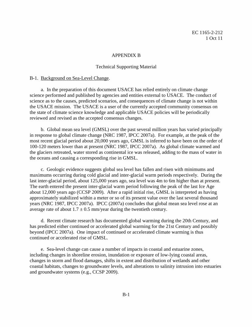
epoch duration (about 40 years) before being used to estimate a local MSL trend. Figure B-2
(from Zervas, 2009) shows the relationship between period of record and the standard error of
the trend for selected US tide stations. Note the significant decrease in standard error
approximately at the 40- or 50-year period of record. Record lengths shorter than 40-years in
duration could have significant uncertainty compared to their potential numerical trend values of
a few millimeters per year.
e. Figure B-2 qualitatively illustrates the asymptotic nature of increasing record length vs.
decreasing standard error of the trend estimate, indicating that standard error of the trend
estimate can be can be large for tide stations with shorter records compared to those with longer
records. Figure B-3 (from Zervas, 2009) shows the mean-sea level trend 95% confidence
interval versus year range of data, with actual data and the least-squares fitted line. The 95%
confidence interval from the least-squares fitted line reduces to less than 1 mm/year once at least
40 years of gauge data are available. Figures B-2 and B-3 thus support the suggestion that a tide
station should have at least 40 years of data before being used to estimate a local MSL trend,
particularly when such a trend will be extrapolated into the future for use as a minimum baseline
for projected future change in local MSL. For project planning and design supporting the entire

EC 1165-2-212
1 Oct 11
B-4
project life cycle, the actual standard error of the estimate should be calculated for each tide gauge
data trend analysis, and the estimates in Figures B-2 and B-3 should not be used as the sole
supporting data.
f. Using trends in relative mean sea level from records shorter than 40 years is not
advisable. In addition to interpretations by the International Oceanographic Commission and
NOAA (Figures B-2 and B-3), Pugh (1987) demonstrates that 10-year records at some stations
show trends of opposite sign depending upon the interval selected. If estimates based on shorter
terms are the only option, then the local trends must be viewed in a regional context, considering
trends from simultaneous time periods from nearby stations to ensure regional correlation and to
minimize anomalous estimates. The nearby stations should have long enough records (greater
than 40 years) to determine reasonable trends, which can then be compared to the shorter, local
sea-level records (see paragraph B-2(h)(2)). Experts at NOAA/NOS should be able to assist in
cases of short periods of record or where records are otherwise ambiguous.
g. The Permanent Service for Mean Sea Level (PSMSL), which is a component of the UK
Natural Environment Research Council’s Proudman Oceanographic Laboratory, has been
collecting, publishing, analyzing, and interpreting sea-level data from the global network of tide
stations since 1933. Global sea level data can be obtained from PSMSL via their web site
(http://www.pol.ac.uk/psmsl/). PSMSL should be considered as a source of information for non-
U.S. stations not contained in the NOAA report. Please note that the periods of record of
PSMSL gauges vary; some gauges have shorter periods of record than are recommended for
relative sea-level change trend analysis.
h. The historic rate of relative sea-level change at relevant local tide stations shall be used
as the low rate for analysis. The current, historically-based rate of change shall be estimated
from local tide station records if oceanographic and geologic conditions at the tide station are
determined to be similar to and consistent with those at the project site (Appendix C). For many
locations along the U.S. Atlantic and Gulf of Mexico coastlines, there are probably adequate tide
station data from perspectives of both spatial density and record duration to permit extrapolating
with an adequate degree of confidence. Recognized exceptions are the coastlines between
Mobile, Alabama and Grand Isle, Louisiana, and in Pamlico/Albemarle Sounds, North Carolina,
which contain no acceptable long-term tide-gauge records. Coastal Louisiana is also subject to
extreme rates of subsidence. In the case where there is a tidal station that is close to a project but
has a short historic data duration, and another tidal station that is farther away but has a longer
historic data duration, a tidal hydrodynamics expert should be consulted as to the appropriate use
of the closer tidal station data.
EC 1165-2-212
1 Oct 11
B-5
Figure B-2. Standard Error of Linear Trend of Sea-level Change vs. Period of
Record, U.S. Tide Stations.
Figure B-3. +/- 95% confidence interval of linear MSL trends (mm/yr)
versus year range of data. The least squares fitted line is also shown
(Zervas, 2009).
0
0.2
0.4
0.6
0.8
1
1.2
1.4
0 20 40 60 80 100 120 140 160
Year Range of Data
Tre
nd
Sta
nd
ard
Err
or
(mm
/yr)
Atlantic Ocean, Eastern Gulf of Mexico, and Carribean Sea
Pacific Ocean, Western Gulf of Mexico, and Bermuda
0.01
0.10
1.00
10.00
10 100 1000
Year Range of Data
+/-
95
% C
on
fid
en
ce
In
terv
al
of
Tre
nd
(m
m/y
r)
Atlantic, Eastern Gulf of Mexico, and Caribbean
Pacific, Western Gulf of Mexico, and Bermuda
Best Fit Line y = 395.5 / ( x**1.6431 )

EC 1165-2-212
1 Oct 11
B-6
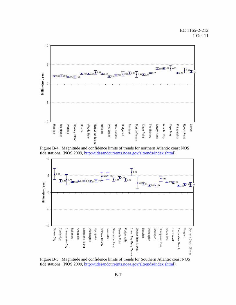
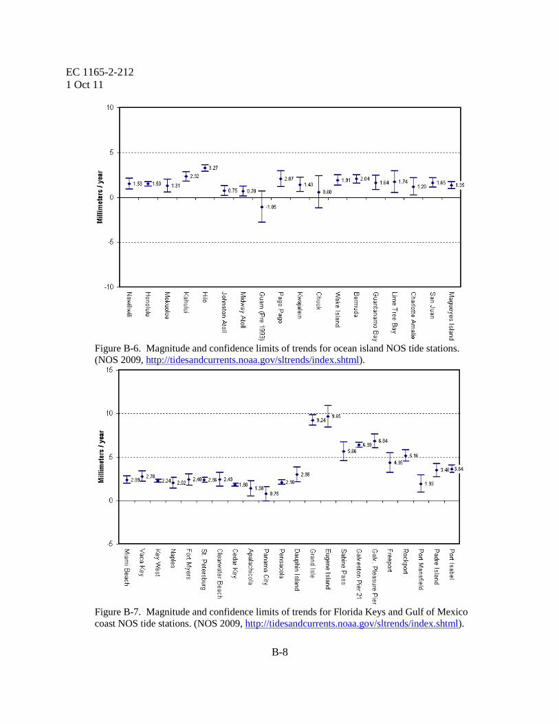
(1) Figures B-4 through B-7show the magnitude and confidence limits (based on standard
error of the estimate) of trends for Atlantic coast, Gulf of Mexico, and tropical NOS tide stations
(from Zervas, 2009, see updated information online at
http://tidesandcurrents.noaa.gov/sltrends/slrmap.html). A pair of stations useful for illustrating
the effect of record length on confidence limits is Galveston Pier 21 and Galveston Pleasure Pier
(Figure B-7). These stations are located within approximately one mile of each other, with
Pleasure Pier on the ocean side and Pier 21 on the navigation waterway side of Galveston Island.
The Pier 21 station was established in 1908 and Pleasure Pier station in 1957, thus Pier 21 has
approximately 103 years of record and Pleasure Pier approximately 54 years. The confidence
limits on Pier 21 are significantly narrower than for Pleasure Pier.
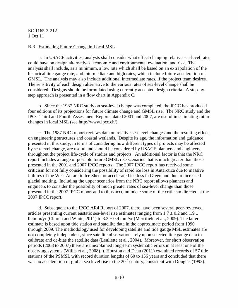
(2) Figures B-8 and B-9 show sea level trends and confidence limits for U.S. Pacific coast
stations. Because of the scatter of trends and confidence limits, estimating historical sea-level
change for many sites along the U.S. Pacific coast may be problematic. Confidence limits are
not as uniform as for the Atlantic and tropical stations. Estimating and extrapolating trends
based upon available data will require engineering judgment on a case-by-case basis and, to be
robust, should take advantage of interdisciplinary and interagency subject matter expertise. It
may be possible, depending upon station location and proximity to nearby stations with longer
records, to use the longer record trend as a proxy providing the two records are well correlated
for the concurrent period of record.
i. Regional sea-level change rates should be evaluated as well as rates of local sea-level
change and global sea-level change. Regional sea-level change rates are expected to be close to
global sea-level change rates, but differences may be found in large, semi-enclosed water bodies.
Areas which could experience regional rates different than global rates include the northern Gulf
of Mexico, the Gulf of Maine, and the Gulf of Alaska.
j. The length of time that the historical record rate of change can be validly projected into
the future depends upon at least the following factors:
(1) the confidence of the present trend
(2) local relative rate of change (little or no acceleration)
(3) global rate of change (little or no acceleration)
(4) absence of dramatic geologic or oceanographic events.
EC 1165-2-212
1 Oct 11
B-7
Figure B-4. Magnitude and confidence limits of trends for northern Atlantic coast NOS
tide stations. (NOS 2009, http://tidesandcurrents.noaa.gov/sltrends/index.shtml).
Figure B-5. Magnitude and confidence limits of trends for Southern Atlantic coast NOS
tide stations. (NOS 2009, http://tidesandcurrents.noaa.gov/sltrends/index.shtml).
EC 1165-2-212
1 Oct 11
B-8
Figure B-6. Magnitude and confidence limits of trends for ocean island NOS tide stations.
(NOS 2009, http://tidesandcurrents.noaa.gov/sltrends/index.shtml).
Figure B-7. Magnitude and confidence limits of trends for Florida Keys and Gulf of Mexico
coast NOS tide stations. (NOS 2009, http://tidesandcurrents.noaa.gov/sltrends/index.shtml).
EC 1165-2-212
1 Oct 11
B-9
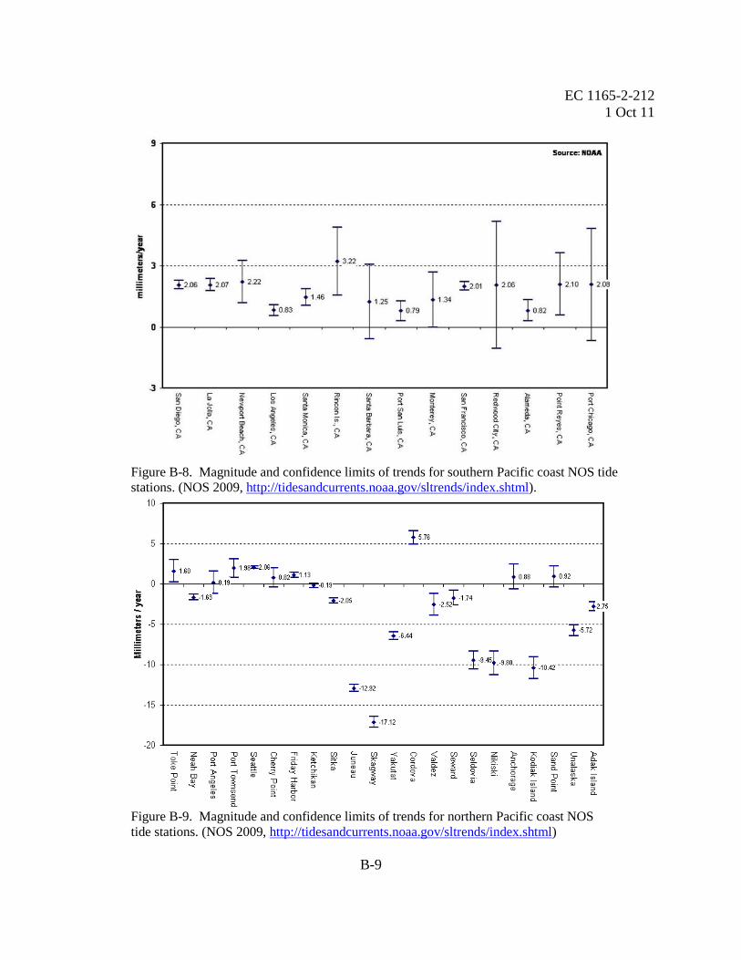
Figure B-8. Magnitude and confidence limits of trends for southern Pacific coast NOS tide
stations. (NOS 2009, http://tidesandcurrents.noaa.gov/sltrends/index.shtml).
Figure B-9. Magnitude and confidence limits of trends for northern Pacific coast NOS
tide stations. (NOS 2009, http://tidesandcurrents.noaa.gov/sltrends/index.shtml)
EC 1165-2-212
1 Oct 11
B-10
B-3. Estimating Future Change in Local MSL.
a. In USACE activities, analysts shall consider what effect changing relative sea-level rates
could have on design alternatives, economic and environmental evaluation, and risk. The
analysis shall include, as a minimum, a low rate which shall be based on an extrapolation of the
historical tide gauge rate, and intermediate and high rates, which include future acceleration of
GMSL. The analysis may also include additional intermediate rates, if the project team desires.
The sensitivity of each design alternative to the various rates of sea-level change shall be
considered. Designs should be formulated using currently accepted design criteria. A step-by-
step approach is presented in a flow chart in Appendix C.
b. Since the 1987 NRC study on sea-level change was completed, the IPCC has produced
four editions of its projections for future climate change and GMSL rise. The NRC study and the
IPCC Third and Fourth Assessment Reports, dated 2001 and 2007, are useful in estimating future
changes in local MSL (see http://www.ipcc.ch/).
c. The 1987 NRC report reviews data on relative sea-level changes and the resulting effect
on engineering structures and coastal wetlands. Despite its age, the information and guidance
presented in this study, in terms of considering how different types of projects may be affected
by sea-level change, are useful and should be considered by USACE planners and engineers
throughout the project life-cycle of studies and projects. An additional factor is that the NRC
report includes a range of possible future GMSL rise scenarios that is much greater than those
presented in the 2001 and 2007 IPCC reports. The 2007 IPCC report has received some
criticism for not fully considering the possibility of rapid ice loss in Antarctica due to massive
failures of the West Antarctic Ice Sheet or accelerated ice loss in Greenland due to increased
glacial melting. Including the upper scenarios from the NRC report allows planners and
engineers to consider the possibility of much greater rates of sea-level change than those
presented in the 2007 IPCC report and to thus accommodate some of the criticism directed at the
2007 IPCC report.
d. Subsequent to the IPCC AR4 Report of 2007, there have been several peer-reviewed
articles presenting current eustatic sea-level rise estimates ranging from 1.7 ± 0.2 and 1.9 ±
0.4mm/yr (Church and White, 2011) to 3.2 ± 0.4 mm/yr (Merrifield et al., 2009). The latter
estimate is based upon tide station and satellite data in the approximate period from 1990
through 2009. The methodology used for developing satellite and tide gauge MSL estimates are
not completely independent, since satellite observations rely upon selected tide gauge data to
calibrate and de-bias the satellite data (Leuliette et al., 2004). Moreover, for short observation
periods (2003 to 2007) there are unexplained long-term systematic errors in at least one of the
observing systems (Willis et al., 2008). ). Houston and Dean (2011) examined records of 57 tide
stations of the PSMSL with record duration lengths of 60 to 156 years and concluded that there
was no acceleration of global sea level rise in the 20th
century, consistent with Douglas (1992).

EC 1165-2-212
1 Oct 11
B-11
Regardless of the observing system used, the premise here is that at least 40 years of data are
required to establish a robust sea-level trend.
e. Because the methodology described in this EC uses a scenario-based approach, it may
be useful to consider an upper bound on 21st
century eustatic sea-level rise. Several peer-
reviewed publications have proposed maximum estimates of GMSL rise by year 2100. Although
the authors use different physical bases to arrive at the estimates, none of them proposes a 21st
century GMSL rise greater than 2 meters. Figure B-10 illustrates the minimum and maximum
GMSL change expected by year 2100, along with author or publication. Based upon these
bodies of research, it seems reasonable that a credible upper-bound for 21st century GMSL rise
would be about 2 meters. This by no means suggests that 21st
century GMSL rise cannot exceed
2 meters, but a maximum of 2 meters is reasonable at this time.
Figure B-10. Comparison of maximum and minimum estimates of global SLR by year 2100.
f. The 1987 NRC report recommended that feasibility studies for coastal projects consider
the high probability of accelerating GMSL rise and provided three different scenarios. The 1987
NRC described these three scenarios using the following equation:
E(t) = 0.0012t + bt2
(1)
in which t represents years, starting in 1986, b is a constant, and E(t) is the eustatic sea-level
change, in meters, as a function of t. The NRC committee recommended “projections be updated
approximately every decade to incorporate additional data.” At the time the NRC report was
0.00 0.20 0.40 0.60 0.80 1.00 1.20 1.40 1.60 1.80 2.00 2.20
NRC 1987
IPCC 2001
IPCC 2007
Rahmstorf 2007
Horton 2008
Pfeffer 2008
Vermeer 2009
Jevrejeva 2010
Sea Level Rise (meters)
maximum estimate
minumum estimate

EC 1165-2-212
1 Oct 11
B-12
prepared, the estimate of global mean sea-level change was approximately 1.2 mm/year. Using
the current estimate of 1.7 mm/year for GMSL change, as presented by the IPCC (IPCC 2007),
results in this equation being modified to be:
E(t) = 0.0017t + bt2
(2)
(1) The three scenarios proposed by the NRC result in global eustatic sea-level rise values,
by the year 2100, of 0.5 meters, 1.0 meters, and 1.5 meters. Adjusting the equation to include
the historic GMSL change rate of 1.7 mm/year and the start date of 1992 (which corresponds to
the midpoint of the current National Tidal Datum Epoch of 1983-2001), instead of 1986 (the start
date for equation 1), results in updated values for the variable b being equal to 2.71E-5 for
modified NRC Curve I, 7.00E-5 for modified NRC Curve II, and 1.13E-4 for modified NRC
Curve III. The three GMSL rise scenarios updated from NRC (1987) are depicted in Figure B-
11.
Figure B-11. Scenarios for GMSL Rise (based on updates to NRC 1987 equation).
(2) Manipulating equation (2) to account for the fact that it was developed for eustatic sea-
level rise starting in 1992, while projects will actually be constructed at some date after 1992,
results in equation (3):
E(t2) – E(t1) = 0.0017(t2 – t1) + b(t22 – t1
2) (3)
EC 1165-2-212
1 Oct 11
B-13
where t1 is the time between the project’s construction date and 1992 and t2 is the time between a
future date at which one wants an estimate for sea-level change and 1992 (or t2 = t1 + number of
years after construction) (Knuuti, 2002). For example, if a designer wants to know the projected
eustatic sea-level rise at the end of a project’s period of analysis, and the project is to have a fifty
year life and is to be constructed in 2013, t1 = 2013 – 1992 = 21 and t2 = 2063 – 1992 = 71.
g. From the Special Report on Emissions Scenarios (SRES) (IPCC 2000), six emissions
scenarios were used to develop six SLR projections. A suite of numerical models that model air-
ocean global circulation, with varying degrees of robustness, were used to provide a range of
results. For each of these models, IPCC used the six different climate change scenarios for input
(see Appendix B-3 for other contributing factors). GMSL rise was calculated for each of the six
scenarios by averaging the modeled sea-level values at every model grid cell, for every
numerical model.
(1) IPCC used the different emissions scenarios and the range of values obtained from the
different numerical models to develop ranges of future GMSL values, and used this as a way to
describe the uncertainty associated with projecting future GMSL. These ranges are shown in
Table B-1 (for two climate change scenarios, B1 and A1FI, the least and most extreme).
(2) An example of an IPCC intermediate level of model-derived GMSL (scenario A1B) is
shown in Figure B-12. Note that the blue shaded area of this figure represents a potential level
of uncertainty for the scenario shown, based on the range of model predictions, and does not
provide a quantitative estimate. Figure B-13 presents the modified NRC curves of Figure B-10
plus the reported 95% confidence limits of the B1 and A1FI scenarios shown in Table B-1 (IPCC
2007a). It should be noted that the confidence limits shown in these tables only describe the
confidence of the range of model results and do not actually represent the confidence of what
could physically occur in the future.
Table B-1. Projected GMSL components during the 21st century for the B1 and A1FI
scenarios. The table gives the IPCC’s reported 5% and 95% confidence limit (m) of
the estimated rise in sea level between 1980 to 1999 and 2090 to 2099 based on the
SRES models (excerpted from IPCC 2007a, Table 10.7). The confidence limits
shown in these tables only describe the confidence of the range of model results and
do not actually represent the confidence of what could physically occur in the future.
B1 A1FI
5% CL 95% CL 5% CL 95% CL
GMSL rise, 2090-2099(m) 0.18 0.38 0.26 0.59

EC 1165-2-212
1 Oct 11
B-14
Figure B-12. Illustration of GMSL (deviation from the 1980-1999 mean) as observed
since 1870 and projected for the future. The future projections have been calculated
independently from the observations (after IPCC 2007a, FAQ 5.1, Figure 1).
Figure B-13. Modified NRC (1987) GMSL rise scenarios and the IPCC (2007) scenario
estimates for use in predicting future sea-level change.

EC 1165-2-212
1 Oct 11
C-1
APPENDIX C
Flowchart to Account for Changes in Mean Sea Level
C-1. Premise. Global mean sea level (GMSL) has risen over the past century, and the rate of
rise will continue and may accelerate in the future. USACE projects need to be planned,
designed, constructed, and operated with the understanding that the rate of rise of GMSL may
increase and affect USACE water resource projects in and adjacent to the nation’s coastal zone.
In other locations, the relative sea-level is dropping, and USACE projects must account for the
decrease in water levels and must balance this with the potential for increasing GMSL. The
steps below are shown graphically in Figure C-1.
C-2. Flowchart.
Step 1. Is the project in the coastal/tidal/estuarine zone, or does it border those zones such that
project features or outputs are now, or may be in the future, subject to influence by
continued or accelerated rate of local relative sea-level change? YES-NO?
a. If YES, go to Step 2.
b. If NO, continue with product development process without considering sea-level
change.
Step 2. Locate nearest tide station(s) with a current period of record. Is the period of record at
least 40 years? YES-NO?
a. If YES, go to Step 4.
b. If NO, go to Step 3.
Step 3. Identify next closest long-term gauge. Assess whether or not the long-term gauge can
be used to artificially extend the record of the short-term gauge. YES-NO?
a. If YES, go to Step 4.
b. If NO, Consult with a tidal hydrodynamics expert, such as CO-OPS1.
1 CO-OPS: Center for Operational Oceanographic Products and Services, National Ocean Service, National
Oceanographic and Atmospheric Administration, Silver Spring, MD 301-7132981. http://tidesandcurrents.noaa.gov
EC 1165-2-212
1 Oct 11
C-2
Step 4. Assess whether identified long-term gauges can be used to adequately represent local
sea-level conditions at project site. YES-NO?
a. If YES, go to Step 5.
b. If NO, Consult with a tidal hydrodynamics expert, such as CO-OPS.
Step 5. Assess whether the project site and gauge site have similar physical conditions
(coastal/estuarine location, bathymetry, topography, shoreline geometry, and
hydrodynamic conditions). YES-NO?
a. If YES, go to Step 6.
b. If NO, Consult with a tidal hydrodynamics expert, such as CO-OPS.
Step 6. Calculate local historic trends for MSL, MHW, and MHHW at long-term gauge. Use
CO-OPS values, if available. If not available, use CO-OPS method for sea-level trend
analysis.1 This historic trend is now the low or baseline trend rate for project
alternative analysis (see 8(a)). Go to Step 7.
Step 7. Calculate standard error of the linear trend line (use CO-OPS values, if available). Go
to Step 8.
Step 8. The next step is to evaluate whether there is a regional mean sea-level trend (see
definition) that is different from the eustatic mean sea-level trend of 1.7 mm/year (+/-
0.5 mm/year, IPCC 2007a). See Figure C-2 for one example of such a region.
Considering regional geology, is it possible to identify a vertically stable geologic
platform within the same region as the project site? YES-NO?
a. If YES, go to Step 9.
b. If NO, go to Step 11.
Step 9. Calculate regional MSL trend for the identified vertically stable geologic platform
within the region, and go to Step 10.
Step 10. Estimate local rate of vertical land movement by subtracting regional MSL trend from
local MSL trend. Go to Step 12.
Step 11. Assume the regional mean sea-level trend is equal to the eustatic mean sea-level trend
of 1.7 mm/year (+/-0.5mm/year) and estimate local rate of vertical land movement by
subtracting eustatic MSL trend from local MSL trend. Go to Step 12.
1 CO-OPS method for sea-level trend analysis is described in NOAA Technical Report NOS CO-OPS 36, "Sea
Level Variations of the United States 1854-1999.”.

EC 1165-2-212
1 Oct 11
C-3
Step 12. Calculate future values for sea-level change for low (historic or baseline) rate:
extrapolate historic linear trend into future at 5-year increments, OR reasonable
increments based on both period of analysis and scope of study1. Go to Step 13.
Step 13. Calculate future values for sea-level change for intermediate rate (modified NRC Curve
I), see 8(a)(1): calculate future sea-level change values at 5-year increments OR
reasonable increments based on both period of analysis and scope of study by
combining incremental values from equations B-2 and B-3 with values obtained by
extrapolating rate of local vertical land movement. Go to Step 14.
Step 14. Calculate future values for sea-level change for high rate (modified NRC Curve III),
see 8(a)(2): calculate future sea-level change values at 5-year increments OR
reasonable increments based on both period of analysis and scope of study by
combining incremental values from equations B-2 and B-3 with values obtained by
extrapolating rates of local vertical land movement. Go to Step 15.
Step 15. Assess project performance for each sea-level change scenario developed in Steps 12,
13, and 14. This assessment and Steps 15-18 can occur at any point in the project life-
cycle, and thus apply to existing as well as proposed projects. Go to Step 16.
Step 16. Calculate the risk for each project design alternative combined with each sea-level
change scenario, as developed in Steps 12, 13, and 14 at 5-year increments OR
reasonable increments based on both period of analysis and scope of study. Go to Step
17.
Step 17. Assess risk2 and reevaluate project design alternatives. Consider at a minimum:
planning for adaptive management1, designing to facilitate future modifications, and
designing for a more aggressive future sea-level change scenario. Go to Step 18.
Step 18. Select project designs that best accommodate the range of sea-level change scenarios
throughout the project life cycle.
1 Use 5-yr increments unless alternate reasonable increments based on both period of analysis and scope of study
can be justified. The number of scenarios may be determined through exploratory or iterative analysis. 2 Policies are under development at the time of this EC.

EC 1165-2-212
1 Oct 11
C-4
Figure C-1. Graphical illustration of process to account for changes in mean sea level.
a) Is the project in or bordering coastal/tidal/estuarine (CTE) zone such that project features or outputs are now, or may be in the future, subject to influence by continued or accelerated rate of change?
b) Discuss with tidal hydrodynamics expert, such as CO-OPS (NOAA). c) Similar physical conditions such as coastal/estuarine location, bathymetry, topography, shoreline geometry,
and hydrodynamic conditions. d) Use CO-OPS (NOAA) values, if available. e) Low rate: extrapolate historic linear trend into future at selected increments. f) Intermediate rate (IPCC-2007, or modified NRC-Curve-I: calculate future SLC values at selected increments
by combining incremental values from equations A-2 and A-3 with value obtained by extrapolating rate of local vertical land movement.
g) High rate (modified NRC-Curve-III): calculate future SLC values at selected increments by combining incremental values from equations A-2 and A-3 with value obtained by extrapolating rate of local vertical land movement.
h) Consider project design function at all phases of the project life cycle: performance, design issues; project stability; and project operation and maintenance.
i) Calculate the risk for each project alternative at selected increments. This assessment and Steps 15-18 can occur at any point in the project life-cycle, and thus apply to existing as well as proposed projects.
j) Consider at a minimum: planning for adaptive management (updating operational strategies based on new information); designing to facilitate future modifications; and adaptive engineering (designing for a more aggressive future SLC scenario
EC 1165-2-212
1 Oct 11
C-5
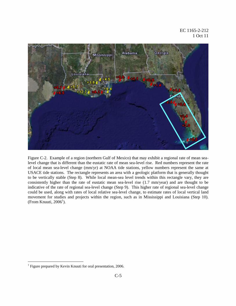
Figure C-2. Example of a region (northern Gulf of Mexico) that may exhibit a regional rate of mean sea-
level change that is different than the eustatic rate of mean sea-level rise. Red numbers represent the rate
of local mean sea-level change (mm/yr) at NOAA tide stations, yellow numbers represent the same at
USACE tide stations. The rectangle represents an area with a geologic platform that is generally thought
to be vertically stable (Step 8). While local mean-sea level trends within this rectangle vary, they are
consistently higher than the rate of eustatic mean sea-level rise (1.7 mm/year) and are thought to be
indicative of the rate of regional sea-level change (Step 9). This higher rate of regional sea-level change
could be used, along with rates of local relative sea-level change, to estimate rates of local vertical land
movement for studies and projects within the region, such as in Mississippi and Louisiana (Step 10).
(From Knuuti, 20061).
1 Figure prepared by Kevin Knuuti for oral presentation, 2006.

EC 1165-2-212
1 Oct 11
Glossary-1
GLOSSARY
Terms and Abbreviations
Coastal. The term coastal as used in this EC refers to locations with oceanic astronomical tidal
influence, as well as connected waterways with base-level controlled by sea-level. In these latter
waterways, influence by wind-driven tides may exceed astronomical tidal influence. Coastal
areas include marine, estuarine, and riverine waters and affected lands. (The Great Lakes are not
considered “coastal” for the purposes of this EC.)
Datum. A horizontal or vertical reference system for making survey measurements and
computations. A set parameters and control points used to accurately define the three-
dimensional shape of the earth. The datum defines parts of a geographic coordinate system that
is the basis for a planar coordinate system. Horizontal datums are typically referred to ellipsoids,
the State Plane Coordinate System, or the Universal Transverse Mercator Grid System. Vertical
datums are typically referred to the geoid, an Earth model ellipsoid, or a Local Mean
Sea Level (LMSL). The current vertical datum used in the United States is the North American
Vertical Datum of 1988 (NAVD 88) which replaced the National Geodetic Vertical Datum of
1929 (NGVD 29) (formerly referred to as the Sea Level Datum of 1929). For tidal datums see
below.
Eustatic sea-level rise. Eustatic sea-level rise is a change in global average sea level brought
about by an increase in the volume of the world ocean [Intergovernmental Panel on Climate
Change (IPCC) 2007b].
Global mean sea-level (GMSL) change. Sea level can change globally due to (i) changes in the
shape of the ocean basins, (ii) changes in the total mass of water and (iii) changes in water
density. Sea-level changes induced by changes in water density are called steric. Density
changes induced by temperature changes only are called thermosteric, while density changes
induced by salinity changes are called halosteric (IPCC 2007b). See Figure B-10.
Local (i.e., “relative”) sea level. Sea level measured by a tide gauge with respect to the land
upon which it is situated. See mean sea level (MSL) and sea-level change (SLC). Relative sea-
level change occurs where there is a local change in the level of the ocean relative to the land,
which might be due to ocean rise and/or land level subsidence. In areas subject to rapid land-
level uplift, relative sea level can fall (IPCC 2007b). Relative sea level change will also affect
the impact of any regional sea level change.
Mean sea level (MSL). A tidal datum. The arithmetic mean of hourly heights observed over the
National Tidal Datum Epoch (~19 years). Shorter series are specified in the name; e.g., monthly
mean sea level and yearly mean sea level (Hicks et al. 2000).
EC 1165-2-212
1 Oct 11
Glossary-2
Post-glacial rebound. The vertical movement of the land and sea floor following the reduction of
the load of an ice mass, for example, since the last glacial maximum (~21,000 years ago). The
rebound is an isostatic land movement (IPCC 2007b).
Regional sea-level change. An increase or decrease in the mean level of the ocean’s surface over
a specific region. Global sea level has regional variations and regional sea-level change may be
equal to, greater than, or less than global sea-level change due primarily to regional differences
in ocean heating and cooling or to changes in bathymetry. Regional sea-level change as used
here does not include local geologic effects, such as subsidence or tectonic movement.
Risk. Risk is a measure of the probability and severity of undesirable consequences (including,
but not limited to, loss of life, threat to public safety, environmental and economic damages).
Sea-level change. A change in the mean level of the ocean.
Tide station. A device at a coastal location (and some deep-sea locations) that continuously
measures the level of the sea with respect to the adjacent land. Time averaging of the sea level
so recorded gives the observed secular changes of the relative sea level (IPCC 2007b).
Tidal datums. The term tidal datum is used when defined in terms of a certain phase of the tide.
Tidal datums are local datums and should not be extended into areas which have differing
hydrographic characteristics without substantiating measurements. In order that they may be
recovered when needed, such datums are referenced to fixed points known as bench marks.
Uncertainty. Uncertainty is the result of imperfect knowledge concerning the present or future
state of a system, event, situation, or (sub) population under consideration. There are two types
of uncertainty: aleatory and epistemic. Aleatory uncertainty is the uncertainty attributed to
inherent variation which is understood as variability over time and/or space. Epistemic
uncertainty is the uncertainty attributed to our lack of knowledge about the system (e.g., what
value to use for an input to a model or what model to use). Uncertainty can lead to lack of
confidence in predictions, inferences, or conclusions.
June 2012
US Army Corps of Engineers •
USACE 2012 Climate Change Adaptation Plan
and Report

i
USACE 2012 Climate Change Adaptation Plan and Report
Executive Summary
The hydrologic and coastal processes underlying water resources management are very sensitive to changes in climate and weather. The US Army Corps of Engineers (USACE) has a compelling need to understand and adapt to climate change and variability because our Civil Works Program and associated water resources infrastructure represent a tremendous Federal investment that supports public safety and local and national economic growth. In response to growing body of evidence about climate impacts to our missions and operations, we published a foundational report with other water resources agencies: Climate Change and Water Resources Management: A Federal Perspective. Since that time, we have developed a governance structure to support mainstreaming adaptation by establishing an overarching USACE Climate Change Adaptation Policy Statement and a Climate Change Adaptation Steering Council. This policy requires USACE to mainstream climate change adaptation in all activities to help enhance the resilience of our built and natural water-resource infrastructure and reduce its potential vulnerabilities to the effects of climate change and variability. Based on the best available and actionable science, we identified six adaptation priority areas. Our progress on these priorities benefits from extensive interagency collaboration and an active program to improve our knowledge about climate change and adaptation. For example, we are undertaking collaborative efforts to define user needs for actionable science, developing a training program to build technical capabilities, and conducting adaptation pilot tests. An early and important lesson learned though pilot studies is that establishing even broad and general policy can reduce the time and cost of adaptation. Thus, we are developing policies and guidance to support adaptation planning and implementation now that can be refined over time. This USACE 2012 Adaptation Plan and Report, prepared at the direction of the USACE Adaptation Steering Committee, demonstrates a broad understanding of the challenges posed by climate change to our mission, programs, and operations, and a commitment to undertake specific actions in FY 2013 and beyond to better understand and address those risks and opportunities. We present information about our vision, goals, and strategic approaches, and how we plan and evaluate agency adaptation planning. In describing our programmatic activities supporting climate change adaptation and our efforts to both better understand and to address climate change risks and opportunities, we demonstrate our awareness of cross-cutting activities underway. The plan will be updated annually and will be publicly available to our staff, partners and stakeholders.
ii
USACE 2012 Climate Change Adaptation Plan and Report
Contents
Executive Summary ................................................................................................................................. i
1. Mainstreaming Adaptation ........................................................................................................... 1
2. Governance Framework ................................................................................................................ 3
2.1. Senior Adaptation Point of Contact ...................................................................................... 3
2.2. Adaptation Steering Committee ........................................................................................... 3
2.3. USACE Adaptation Planning Process ..................................................................................... 4
3. Report of Progress to Mainstream Climate Adaptation ............................................................... 4
3.1. USACE Adaptation Priority Areas .......................................................................................... 5
3.1.1. The US National Action Plan to Manage Freshwater Resources in a Changing Climate .. 6
3.1.2. Risk-Informed Decision-Making for Climate Change ........................................................ 8
3.1.3. Nonstationarity ................................................................................................................. 8
3.1.4. Portfolio of Approaches .................................................................................................. 10
3.1.5. Continued Vulnerability Assessments ............................................................................. 10
3.1.6. Metrics and Endpoints .................................................................................................... 11
3.2. External Collaboration ........................................................................................................ 12
3.2.1. Interagency Climate Change Adaptation Task Force ...................................................... 12
3.2.2. Federal Agency Adaptation Community of Practice ....................................................... 13
3.2.3. US Global Change Research Program Adaptation Science Working Group.................... 14
3.2.4. Climate Change and Water Working Group ................................................................... 15
3.3. Improving Our Knowledge .................................................................................................. 15
3.3.1. Pilot Studies .................................................................................................................... 16
3.3.1.1. Lessons Learned .......................................................................................................... 18
3.3.1.2. Additional Pilot Studies ............................................................................................... 18
3.3.2. Identifying User Needs for Adaptation ........................................................................... 20
3.3.2.1. Long-Term Water Resources Planning Decisions ........................................................ 20
3.3.2.2. Short-Term Water Management Decisions ................................................................ 20
3.3.3. Training to Support Adaptation ...................................................................................... 21
3.4. Developing Policy and Guidance Framework ..................................................................... 21
3.4.1. Actions Taken to Support Adaptation ............................................................................. 22
3.4.1.1. Policy and Guidance for Consistent Vertical Datums .................................................. 22

iii
3.4.1.2. Policy and Guidance for Sea-Level Change ................................................................. 22
3.4.1.3. New Guidance Series .................................................................................................. 23
3.4.2. Ongoing Actions to Support Adaptation ......................................................................... 23
3.4.2.1. Guidance on Adapting to Sea-Level Change ............................................................... 23
3.4.2.2. Guidance on Appropriate Use of Paleoflood Information .......................................... 24
3.4.2.3. Climate Change and Inland Hydrology Guidance ........................................................ 24
4. Summary and Conclusions .......................................................................................................... 25
5. References .................................................................................................................................. 26
APPENDIX A: Excerpts from High-Level Vulnerability Analysis .......................................................... A-1

1
1. Mainstreaming Adaptation
Global changes, including changing demographics and population growth rates, varying land use/land cover types, decaying and aging infrastructure, continuing global conflicts, declining biodiversity, increasing globalization pressures, altering social values and economic conditions, and transitioning climate, all impact USACE Civil Works and Military Programs Missions. USACE has the responsibility to characterize and understand all potential threats to its missions, operations, programs and projects from these global changes and their interactions. We also have the responsibility to engineer and deploy adaptation strategies and policies that reduce these threats where they currently or are expected to appear. Effective climate change adaptation is especially important for USACE because the hydrologic processes underlying water resources management are very sensitive to changes in climate and weather. Our Civil Works Program and associated water resources infrastructure represent a tremendous Federal investment that supports public safety and local and national economic growth, and hence, we have a compelling need to understand and adapt to climate change and variability. The primary and overarching policy document for USACE is the USACE Climate Change Adaptation Policy Statement1, signed by Assistance Secretary of the Army Ms. Jo-Ellen Darcy on 3 June 2011, in accordance with the Implementing Instructions for Federal Agency Climate Change Adaptation 2(Council on Environmental Quality (CEQ) and Office of Management and Budget (OMB) 2011), and also the Guiding Questions contained in the companion Support Document to the Implementing Instructions (CEQ 2011).
Simply stated, this policy requires USACE to mainstream climate change adaptation in all activities to help enhance the resilience of our built and natural water-resource infrastructure and reduce its potential vulnerabilities to the effects of climate change and variability. The policy statement also directs USACE to begin adaption now based on the best available and actionable science – and plenty of information is available – and to consider the impacts of climate change when planning for the future (see inset box for the policy’s key points).
1 See http://www.corpsclimate.us/adaptationpolicy.cfm
2 Issued jointly on 4 March 2011 by the Executive Office of the President’s Council on Environmental
Quality/Office of the Federal Environmental Executive (CEQ/OFEE) and the Office of Management& Budget (OMB)
“Mainstreaming climate change adaptation means that it will be
considered at every step in the project lifecycle for all USACE projects,
both existing and planned . . . to reduce vulnerabilities and to enhance
the resilience of our water resource infrastructure”
- Ms. Jo-Ellen Darcy, Assistant Secretary of the Army for Civil
Works, USACE Climate Change Adaptation Policy Statement, 3 June
2011
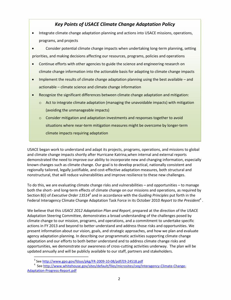
2
USACE began work to understand and adapt its projects, programs, operations, and missions to global and climate change impacts shortly after Hurricane Katrina,when internal and external reports demonstrated the need to improve our ability to incorporate new and changing information, especially known changes such as climate change. Our goal is to develop practical, nationally consistent and regionally tailored, legally justifiable, and cost-effective adaptation measures, both structural and nonstructural, that will reduce vulnerabilities and improve resilience to these new challenges. To do this, we are evaluating climate change risks and vulnerabilities – and opportunities – to manage both the short- and long-term effects of climate change on our missions and operations, as required by Section 8(i) of Executive Order 135143 and in accordance with the Guiding Principles put forth in the Federal Interagency Climate Change Adaptation Task Force in its October 2010 Report to the President4 . We believe that this USACE 2012 Adaptation Plan and Report, prepared at the direction of the USACE Adaptation Steering Committee, demonstrates a broad understanding of the challenges posed by climate change to our mission, programs, and operations, and a commitment to undertake specific actions in FY 2013 and beyond to better understand and address those risks and opportunities. We present information about our vision, goals, and strategic approaches, and how we plan and evaluate agency adaptation planning. In describing our programmatic activities supporting climate change adaptation and our efforts to both better understand and to address climate change risks and opportunities, we demonstrate our awareness of cross-cutting activities underway. The plan will be updated annually and will be publicly available to our staff, partners and stakeholders.
3 See http://www.gpo.gov/fdsys/pkg/FR-2009-10-08/pdf/E9-24518.pdf
4 See http://www.whitehouse.gov/sites/default/files/microsites/ceq/Interagency-Climate-Change-
Adaptation-Progress-Report.pdf
Key Points of USACE Climate Change Adaptation Policy
Integrate climate change adaptation planning and actions into USACE missions, operations,
programs, and projects
Consider potential climate change impacts when undertaking long-term planning, setting
priorities, and making decisions affecting our resources, programs, policies and operations
Continue efforts with other agencies to guide the science and engineering research on
climate change information into the actionable basis for adapting to climate change impacts
Implement the results of climate change adaptation planning using the best available – and
actionable – climate science and climate change information
Recognize the significant differences between climate change adaptation and mitigation:
o Act to integrate climate adaptation (managing the unavoidable impacts) with mitigation
(avoiding the unmanageable impacts)
o Consider mitigation and adaptation investments and responses together to avoid
situations where near-term mitigation measures might be overcome by longer-term
climate impacts requiring adaptation
3
2. Governance Framework
2.1. Senior Adaptation Point of Contact
The USACE Climate Change Adaptation Policy Statement issued 3 June 2011, establishes the Assistant Secretary of the Army for Civil Works as the USACE Senior Adaptation Point of Contact responsible for ensuring implementation of the policy. The 2011 USACE Climate Change Adaptation Policy Statement remains in force and provides the USACE policy framework for climate change adaptation as required by the Council on Environmental Quality in its 29 February 2012 Statement on Preparing Federal Agency Climate Change Adaptation Plans In Accordance with Executive Order 13514.
2.2. Adaptation Steering Committee
The USACE Climate Change Adaptation Policy Statement issued 3 June 2011 established the USACE Climate Change Adaptation Steering Committee (ASC), chaired by the USACE Chief, Engineering and Construction, to oversee and coordinate agency-wide climate change adaptation planning and implementation. The objective of the ASC, chaired by Mr. James C. Dalton, PE, SES (Chief of Engineering and Construction) is to mainstream climate change adaptation planning and actions into our missions, operations, programs, and projects. The ASC acts as the highest level of Adaptation Authority in USACE. The ASC establishes strategic direction; reviews/monitors existing adaptation programs, activities and policy implementation; provides critical decisions related to the implementation of adaptation across USACE, and coordinates the integration of adaptation and mitigation activities with the USACE Strategic Sustainability Committee.
The goals of the USACE Climate Change Adaptation Steering Committee are to:
Oversee and coordinate practical agency-wide climate change adaptation planning and implementation, including adaptation requirements put forth by the Council on Environmental Quality and the Office of Management and Budget.
Promote activities to mainstream climate change adaptation at every step in the project life cycle for all USACE projects, both existing and planned.
Continue to work to understand and adapt to the impacts of climate and global change, particularly the effects of nonstationarity.
“Adaptation is not optional.”
- Mr. James C. Dalton, PE, SES, Chair of the USACE Climate
Change Adaptation Steering Committee, 19 January 2012

4
Facilitate and promote closer and more fruitful interagency cooperation for developing methods supporting climate change adaptation, especially those agencies with similar climate change impacts and challenges.
Promote sharing of impact and adaptation data and information between Federal, State, Local and DoD partners.
Build, sustain and manage a portfolio of best practices and guidance to effectively and efficiently manage USACE adaptation activities and investments.
Rapidly adopt new information, methods, processes, and technology that reduces risk, increases resilience and improves efficiency in adaptation planning and implementation.
Foster an engineering workforce empowered and recognized for deep technical knowledge and experience across the organization.
2.3. USACE Adaptation Planning Process
The USACE climate-change adaptation mission is to improve our resilience and decrease our vulnerability to the effects of climate change and variability. Our goal is to successfully perform our missions, operations, programs, and projects despite the challenges of global and climate change. The USACE strategic approach to accomplishing our adaptation mission is to:
Produce, gather, and select climate change information supporting decision making;
Develop the required policy and guidance supporting adaptation planning and implementation;
Understand where we have the need and capacity for adaptation in a way that improves the resilience and reduces the vulnerability of our missions and operations; so we can
Mainstream and implement climate-change adaptation measures to successfully perform our missions, operations, programs, and projects despite the challenges of global and climate change.
3. Report of Progress to Mainstream Climate Adaptation
USACE has been working for five years now to identify what we know, what we don’t know, and what we can do to fill the knowledge gaps and develop the policy and guidance we need to adapt to climate change. We have analyzed our vulnerability to climate change, including identification of risks and opportunities, and continue to refine these analyses. We understand that our projects are part of a dynamic and evolving system, and that they can change continuously over time (vs. achieving and maintaining a single equilibrium state). Our experience with “wicked water resources” problems has shown us that we must be careful when we implement changes, because our incomplete understanding increases the potential for unintended consequences resulting from actions taken in isolation.
“… improve our resilience and decrease our vulnerability to
the effects of climate change and variability.”
- USACE climate-change adaptation mission

5
We understand the complexities of adaptation because our water resources engineers and managers — and our military staff — are already accustomed to making decisions under deep uncertainty of the kind that climate change brings. It is precisely this engineering ability to adapt to changing problems and conditions that provides a source of institutional and organizational resilience and experience to guide our climate change adaptation. For example, USACE made many difficult choices in 2011 alone in the interests of public safety – choices that were possible only because engineers in the 1920s and 1930s understood that future could bring changing conditions – and they designed options into the system that allowed us to adapt to these conditions.
Our progress to date to support mainstreaming climate change adaptation has focused on clarifying our adaptation mission and goals and developing new policy and guidance to support adaptation implementation at multiple scales, from project-specific to nationwide. We are applying our strategic approaches to the priority areas identified in previous years, with a heavy emphasis on external collaboration and pilot tests to help improve our knowledge so we can make progress on the policy and guidance needed to mainstream adaptation. Two programmatic efforts are the primary supporters of the work performed to date to support mainstreaming of our climate change adaptation policy. These are the Interagency Performance Evaluation Task Force (IPET)/Hurricane Protection Decision Chronology (HPDC) Lessons Learned Implementation Team (also known as the Actions for Change) and the Responses to Climate Change program. These programs, along with the new Reducing Civil Works Vulnerability Program, as proposed in the FY13 budget, will improve the resilience of our built and natural infrastructure benefits through a proactive, nationally consistent, and regionally sensitive framework and program of actions to reduce vulnerabilities to the physical, social and economic environment, as well as from unintended consequences and cascading impacts from other decisions.
3.1. USACE Adaptation Priority Areas
Since 2007, USACE has been assessing the impacts of climate change to its Civil Works activities. The foundational document outlining our perspective on climate change and variability impacts to projects and programs is contained in USGS Circular 1331 Climate Change and Water Resources Management: A Federal Perspective5, published in 2009 (Fig 1). The information in this report and subsequent agency
5 Brekke et al 2009, see http://pubs.usgs.gov/circ/1331/Circ1331.pdf
“Climate change adaptation is a complex process that requires a
thoughtful approach, recognizing the potential for unintended
consequences and cascading impacts.”
- Mr. Terrence C. “Rock” Salt,
Principal Deputy, Assistant Secretary of the Army for Civil Works

6
assessment activities formed the basis for the six adaptation priority areas for action identified in the 2011 USACE Adaptation Plan and Report6 and described in more detail below:
1. National Action Plan to Manage Freshwater Resources in a Changing Climate
2. Risk-Informed Decision-Making for Climate Change 3. Nonstationarity 4. Portfolio of Approaches 5. More Refined Vulnerability Assessments 6. Metrics and Endpoints
USACE is committed to making progress in these priority areas in 2013 and beyond. Additional priorities will be identified in the future as we gain understanding and experience in adapting to climate change.
3.1.1. The US National Action Plan to Manage
Freshwater Resources in a Changing Climate
In their October 2010 Report to the President7, the Federal Interagency Climate Change Adaptation Task Force (ICCATF) presented Federal agency actions needed to better prepare the Nation to respond to the impacts of a changing climate. The ICCATF recommended that their Water Resources and Climate Change Adaptation Workgroup develop a national action plan to identify steps that Federal agencies can take to improve management of freshwater resources in a changing climate. In 2011, the ICCATF released the National Action Plan Priorities for Managing Freshwater Resources in a Changing Climate8 (NAP). The NAP (Fig. 2) makes six major recommendations, each with supporting actions led by different agencies:
1. Establish a planning process to adapt water resources management to a changing climate
2. Improve water resources and climate change information for decision-making
3. Strengthen assessment of vulnerability of water resources to climate change
4. Expand water use efficiency 5. Support Integrated Water Resources Management (IWRM) 6. Support training and outreach to build response capability
6 See http://www.corpsclimate.us/adaptationpolicy.cfm
7 CEQ 2010, see http://www.whitehouse.gov/sites/default/files/microsites/ceq/Interagency-Climate-Change-
Adaptation-Progress-Report.pdf 8 Interagency Climate Change Adaptation Task Force 2011, see
http://www.whitehouse.gov/sites/default/files/microsites/ceq/2011_national_action_plan.pdf
Figure 1. USGS Circular 1331, the fundamental assessment of climate change impacts to water resources management.
Figure 2. The 2011 National Action Plan: Priorities for Managing Freshwater Resources in a Changing Climate.

7
There are 24 specific actions to support these recommendations. USACE is the lead agency to implement the following three supporting actions for Recommendation 5, Integrated Water Resources Management:
Action 17 addresses working with States and interstate bodies (e.g., river basin commissions) to incorporate IWRM into their planning and programs with attention to climate-change adaptation issues. USACE is also supporting pilot studies to address this action. The West Maui Watershed Study (Fig 3) is developing a climate-change adaptation plan for the watershed from the summit to the outer coral reef. Another pilot study is developing a climate-change adaptation strategy with the Ohio River Basin Alliance, a group made up of Federal and State agencies, academia and non-governmental organizations. The goal is to develop practices supporting an IWRM framework for climate change adaptation.
Action 19's goal is to work with states to identify flood risk and drought management "best practices" to prepare for hydrologic extremes that can be shared among the States and Federal agencies. Since this action also requires working closely with the States, the first step is a review of State Hazard Mitigation Plans. The next step is to survey state flood officials to obtain their perspectives on Federal and State agency coordination and their views on innovative policies.
Action 20’s goal is to “develop benchmarks for incorporating adaptive management into water project designs, operational procedures, and planning strategies.” An interagency technical team including USACE, Department of the Interior (DOI) US Geological Survey (USGS), US Department of Agriculture (USDA) Natural Resources Conservation Service (NRCS), US Environmental Protection Agency (EPA), and the National Oceanic and Atmospheric Administration (NOAA), and Forest Service, is working on this action. The team is beginning with an inventory of Federal agencies’ adaptive management practices and policies that will support later recommendations for wider application of adaptive management strategies in the Federal government.
As an operating agency, USACE has a special interest in being sure that proposed adaptive management methods address the needs of operating projects. In contract to adaptive management for natural resources and ecosystems, water resources project operations represent a continuous implementation phase and a shorter response period (e.g., Short et al 2012), as well as different types of thresholds and management decisions. Often, these operations cannot be interrupted without disruption to the
Figure 3. West Maui Watershed Plan IWRM Study Area

8
authorized missions, such as flood risk reduction, navigation, hydropower, and water supply. An additional concern is the ageing of water resources infrastructure and the constrained economic conditions. As pointed out by Kundzewicz et al (2008), adaptation of water resources infrastructure goes beyond the infrastructure to include “forecasting/warning systems, insurance instruments and a plethora of means to improve efficiency of water use (e.g. via demand management) and related behavioural change, economic and fiscal instruments, legislation, institutional change.” The IWRM actions are consistent with the framework laid out in the draft National Fish, Wildlife, and Plants Climate Adaptation Strategy and will help support the implementation of that strategy. In addition to the IWRM actions under Recommendation 5, USACE is co-leading three other actions concerned with climate and water data supporting Recommendation 2. These actions will provide an opportunity to integrate other Federal sources of data and tools with the Federal Support Toolbox. USACE is also co-lead on an action developing training for water managers on climate change supporting Recommendation 6 and described in more detail below in the section on Improving our Knowledge.
3.1.2. Risk-Informed Decision-Making for Climate Change
USACE is developing a risk management framework to incorporate climate change into decision-making. A draft framework completed in FY11 addresses the entire project life cycle, since climate change uncertainty may require making sequential decisions over time and updating design and plans to incorporate new and changing information. Risk assessment includes both consequence and likelihood assessment, and the framework recognizes the potential challenges of assigning probabilities to uncertain future conditions. Formulation of risk management alternatives under changing conditions is a critical component of the approach. The framework emphasizes the need for stakeholder involvement throughout the decision process. Several climate-change adaptation pilot projects are testing the framework. The Hamilton Wetland Restoration Project (HWRP) is testing the proposed risk framework and evaluating its application to the USACE planning phase. The West Maui Watershed Study (Fig. 3) is using the framework to collaboratively identify climate risks and to develop adaptation strategies. The Lower Columbia River Estuary pilot study is applying the framework to ecosystem restoration. An interagency team is employing the risk management strategy to plan for sea level change as part of the development of USACE guidance addressing adaptation to sea-level change. The risk framework is now under revision based on preliminary results from pilot studies and an internal review. The risk management framework will be a foundation for developing strategies to incorporate climate change into the decision making processes of USACE, with FY12 and FY13 priorities being ecosystem restoration, flood risk management, and water management.
3.1.3. Nonstationarity
Developing methods and procedures to address nonstationarity throughout the project life cycle is a priority action for the USACE. Our first action was the January 2010 Workshop on Nonstationarity, Hydrologic Frequency Analysis, and Water Management conducted with our fellow water resources management agencies in the Climate Change and Water Working Group (CCAWWG, see External Collaboration below). A major objective of the workshop was to facilitate Federal interagency efforts to account for nonstationarity in hydrologic frequency analysis. Interagency and other expert participation in the workshop was reported in a special collection of journal papers published in the June 2011 issue

9
of the Journal of the American Water Resources Association9 with an introduction by Kiang et al (2012, Figure 4). The Advisory Committee for Water Information (ACWI) Subcommittee on Hydrology (SOH) Hydrologic Frequency Analysis Work Group (HFAWG) is currently revising Bulletin 17B, Guidelines for Determining Flood Flow Frequency (U.S. Interagency Advisory Committee on Water Data 1982). The new revision will probably include a statement that major changes in climate may be occurring over decades or centuries. Employing time-varying parameters or using other appropriate and statistically justified techniques could allow the impacts of such changes to be incorporated in frequency analyses. However, there will be a number of remaining unanswered questions on what methods to use, and how to justify their use, that must be addressed by USACE and its partner water resources management agencies. In parallel with the revision of Bulletin 17B, USACE, USGS, the Department of Homeland Security (DHS) Federal Emergency Management Agency (FEMA), DOI’s Bureau of Reclamation, and the Department of Transportation (DOT) Federal Highways Administration (FHWA) are embarking on a joint effort to evaluate approaches and other issues regarding nonstationarity, climate change, and flood risk. The first product will be an annotated bibliography of statistical methods to describe nonstationarity in 2012. Future work in 2013 and beyond will address the choice of probability distributions and the potential to use climate projections for estimating future flood likelihoods
9 See http://onlinelibrary.wiley.com/doi/10.1111/jawr.2011.47.issue-3/issuetoc
“During the preceding half century there have been considerable shifts in U.S.
demographics, industrial and agricultural production…. societal objectives, and
improved understanding of ecosystems and ecosystem services…. Hydrologically, the
future is not likely to look like the past, with climate change further straining water
infrastructure, and with areas of the country expected to experience increasing
frequency in both floods and droughts and declining snowpacks in the future.”
- Andrew Warner & Jeffrey Opperman, The Nature Conservancy, and Bob
Pietrowsky, Director, USACE Institute for Water Resources, from “A Call to Enhance the
Resiliency of the Nation’s Water Management,”
ASCE Journal of Water Resources 137(4) 305-308, 15 June 2011
Figure 4. Collaboration around the issue of nonstationarity is demonstrated by a special collection of articles in the June 2011 .J. American Water Resources Association.

10
3.1.4. Portfolio of Approaches
The wide portfolio of possible approaches for producing and using climate science and climate change information for water resource adaptation questions can bewilder planners and engineers because each method or analytical technique in this portfolio brings uncertainties and particular deficiencies, some of which are large or only partly characterized and poorly quantified. Operating and resource management agencies looking to use these techniques to inform their climate adaptation planning currently lack good practice guidelines for helping them assess the approaches and choose appropriate ones for particular adaptation decisions. To help address this need, USACE, together with its partners in the CCAWWG, sponsored a workshop on Assessing a Portfolio of Approaches for Producing Climate Change Information to Support Adaptation Decisions in November 2010. The workshop, with more than 70 participants, provided a platform for representatives from water-related resource Federal agencies to discuss their approaches for producing and using climate change information and to hear from climate science agencies on the possibility and desirability of establishing a multi-agency, common framework of good practice guidelines for assessing the strengths and limits of the approaches. To be useful and adaptable in the face of changing conditions, good practice guidelines for water-resource adaptation decisions will not dictate individual approaches for specific applications. Rather, they will help agencies develop robust, defensible, and reproducible practices for assessing the strengths and limits of different approaches to using climate information at the various choice-points in their decision processes. Ideally, the guidelines will be flexible enough to apply to current state-of-the-science information and future climate science developments. During 2012 and 2013, the CCAWWG workshop organizers will draft and publish a larger report to provide more details on the portfolio of approaches to climate information for water-related adaptation decisions and the first steps identified in the workshop for building guidelines for using those approaches. Selected approaches are being tested through USACE climate change adaptation pilot studies.
3.1.5. Continued Vulnerability Assessments
Climate vulnerability assessments are necessary to help guide adaptation planning and implementation so that USACE can successfully perform its missions, operations, programs, and projects in an increasingly dynamic physical, socioeconomic, and political environment. USACE has completed three activities in connection with addressing vulnerabilities to climate change. The first was a preliminary assessment of how climate could impact Federal water resources management, presented in USGS Circular 1331 (Fig. 1), published in 2009 jointly by USACE, Reclamation, the USGS, and NOAA10. The second was a high-level analysis of the vulnerability of USACE missions and operations to climate change required by the Implementing Instructions for Federal Agency Climate Change Adaptation11 (Council on Environmental Quality (CEQ) and Office of Management and Budget (OMB) 2011), and also the Guiding Questions contained in the companion support document to the Implementing Instructions (CEQ 2011). The CEQ intended this analysis to help each agency identify priorities for future assessment
10
See http://pubs.usgs.gov/circ/1331/ 11
issued jointly on 4 March 2011 by the Executive Office of the President’s Council on Environmental Quality/Office of the Federal Environmental Executive (CEQ/OFEE) and the Office of Management and Budget.(OMB)

11
and implementation actions and support initial or increased awareness of potential climate change impacts to agency missions, operations, policies and programs. The high-level analyses were specifically NOT intended to be detailed vulnerability assessments of specific programs, projects, or geographic regions. The USACE responses to the Guiding Questions are contained in the USACE Climate Change Adaptation Plan and Report 2011 submitted to the Executive Office of the President’s CEQ and the Office of the Federal Environmental Executive on 30 September 201112. Additional information (excerpts of the high-level analysis) is contained in Appendix A. The third activity undertaken was a proof-of-concept study for a screening-level assessment of the vulnerability of USACE mission, operations, programs, and projects to climate change. The proof-of-concept study focused primarily on the potential exposure to climate change-induced changes in freshwater discharge at the level of HUC-4 watersheds. It is the first step in a nationwide USACE screening-level vulnerability assessment to be conducted in phases (so the initial assessment can be refined) using a modular approach (so new and updated information can replace initial information). The analysis builds on existing, national-level tools and data, including specific indicators of vulnerability representing USACE business lines (Fig. 5). The proof-of-concept is currently being refined with updated climate forcing, hydrology, and indicators to provide a screening-level vulnerability assessment at a HUC-4 watershed level.
3.1.6. Metrics and Endpoints
Appropriate frameworks and metrics for assessing the efficiency and effectiveness of climate change adaptation activities are crucial for achieving our combined objectives of developing practical, nationally consistent, legally justifiable, and cost effective climate change actions, both structural and nonstructural; and reducing the vulnerabilities and improving the resilience of water-resource infrastructures at risk from climate change threats. Information about the potential benefits and costs of climate change adaptation and mitigation actions is required to help decision makers considering planning options and actions. At present, decisions about adaptation and mitigation can be made without systematic consideration of relevant information, in part because this information does not exist for many types of climate change problems and candidate actions to address them. This is an especially important issue where adaptation and mitigation actions may interact synergistically or antagonistically, where taking one action would obstruct or preclude another.
12
See http://www.corpsclimate.us/adaptationpolicy.cfm
Figure 5. Example output from the proof-of-concept study for a screening-level assessment of the vulnerability of USACE mission, operations, programs, and projects to climate change.
12
Systematic approaches to gathering and interpreting information about the effectiveness of adaptation and mitigation actions must include, but not be limited to, analysis of their economic costs and benefits. Rather, information to help shape and choose among candidate climate-change actions should include assessments of reductions in climate change vulnerabilities across multiple types of information and combining this in frameworks designed to support timely decision-making. The wrong choice of measures framework within which to evaluate them will hinder our ability to deploy truly sustainable adaptation measures. The right choice of frameworks and metrics will ease the transition to a new organizational culture that integrates and mainstreams climate change adaptation and mitigation throughout the lifecycle of USACE projects and programs. USACE is working internally and with other agencies to understand and develop appropriate information, frameworks, and measures to support decisions that will meet our adaptation goals.
3.2. External Collaboration
USACE understands that close collaboration, both nationally and internationally, is the most effective way to develop practical, nationally consistent, and cost-effective measures to reduce potential vulnerabilities resulting from global changes (Stockton and White 2011). That is why we are working closely with other agencies having aligned mission areas as we work to understand climate change impacts and to develop measures to adapt to these impacts. Our appreciation for the benefits of collaboration is also why we have provided support in the form of our senior engineers and scientists to the Federal Interagency Climate Change Adaptation Task Force (ICCATF) working groups, to the ICCATF Adaptation Community of Practice, and to US Global Change Research Program, among others.
3.2.1. Interagency Climate Change Adaptation Task Force
The USACE has played an active role in the ICCATF since its inception in Spring 2009. The Assistant Secretary of the Army for Civil Works is the USACE representative to the ICCATF, which is composed of more than 20 Federal agencies and Executive branch offices and co-chaired by the CEQ, the National Oceanic and Atmospheric Administration (NOAA), and the Office of Science and Technology Policy (OSTP). In fact, the ICCATF was described in Section 16 of Executive Order 1351413 signed by President Obama on October 5, 2009, as “already [being] engaged in developing the domestic and international dimensions of a U.S. strategy for adaptation to climate change…”
13
See http://www.gpo.gov/fdsys/pkg/FR-2009-10-08/pdf/E9-24518.pdf
“Managing water resources as a collaborative endeavor is becoming
increasingly crucial as society faces demographic, economic, institutional, and
climate changes manifesting across the U.S. and around the globe. These changes
portend a different understanding of the risks associated with the occurrence,
location, intensity and impacts of extreme events—including floods and droughts..”
- Mr. Steven L. Stockton, Director of Civil Works, U.S. Army Corps of Engineers,
in "Responding to National Water Resources Challenges"
13
The ICCATF formed a number of working groups to help develop recommendations to support agency climate change adaptation planning and implementation. USACE actively participated in many of these, including the Agency Adaptation Processes working group (which developed recommendations for the Implementing Instructions (CEQ and OMB 2011)), the Water Resources Working Group (which developed the National Action Plan Priorities for Managing Freshwater Resources in a Changing Climate (Fig. 2), the Fish, Wildlife and Plants Working Group (which developed the draft Fish, Wildlife and Plants Climate Adaptation Strategy14), and Coasts (which provided input to the National Ocean Policy Implementation Plan15).
3.2.2. Federal Agency Adaptation Community of Practice
The Federal Agency Adaptation Community of Practice is a spin-off from the ICCATF’s Agency Adaptation Processes working group, which supported CEQ by developing and hosting a series of workshops to help agencies understand how to perform the preliminary high-level analysis required in September 2011. An active member of the working group, USACE helped develop, presented at, and facilitated these workshops conducted by the working group. From the workshops, it was clear that, while some agencies were active and engaged in all phases of adaptation planning (like USACE), others were at a loss, particularly small agencies and those without technical staff. As a result, the working group developed a Climate Change Adaptation Community of Practice (CoP) in October 2011 to provide a forum for interagency collaboration on facilities and climate change adaptation. The purpose of the CoP is to support federal officials who plan and implement climate-change adaptation actions by building capacity, sharing ideas and practices, and collaborating on adaptation actions. CoP members are Federal employees working to mainstream climate change adaptation in their agencies. The types of knowledge sharing fostered by the CoP include:
Staff training and capacity building
How agencies are evaluating or measuring progress
Communication strategies
Approaches to integrating adaptation into existing programs
Concrete examples of agency adaptation projects and results
How to apply climate change scientific information in agency decision making
Providing agency-specific briefings about progress under their plans The USACE serves as an active member of both the working group and the CoP, and supported information exchange workshops before and after the CoP began. The first focus area of the CoP was the development of the agency adaptation plans (i.e., this report) due June 2012. The CoP designed a series of meetings to help participants develop and implement their own plans, and also to share information with CEQ to help inform guidance or information they may issue in the future related to adaptation planning. Each CoP meeting has focused on different aspects of the adaptation planning process. Meetings to date include:
Federal Facilities and Agency Adaptation Planning
How to Approach Adaptation Planning
Science and Adaptation Planning
14
See http://www.wildlifeadaptationstrategy.gov/ 15
See http://www.whitehouse.gov/administration/eop/oceans/implementationplan

14
Briefings on USACE and DHS Plans
Regional Coordination and Agency Adaptation Planning
Adaptation Planning and the Cross Cutting Strategies addressing Wildlife, Water, and Oceans
Discussion Cafes on the Nuts and Bolts of Adaptation Planning
Ecosystem-Based Adaptation
3.2.3. US Global Change Research Program Adaptation Science Working Group
Since 1989, the U.S. Global Change Research Program (USGCRP) has coordinated and integrated federal research around global changes, including climate change16. The USGCRP is composed of 13 departments and agencies participate in the USGCRP (including Department of Defense but not specifically the USACE). Though USGCRP has focused primarily on science to date, there is an increasing emphasis on supporting adaptation planning and implementation, as evidenced by the four goals of its 10-year strategic plan for the period 2012-2021, released in May 201217. This Plan has four goals:
Advance Science
Inform Decisions
Conduct Sustained Assessment
Communicate and Educate Input from Federal agencies and components of agencies producing or using climate science and climate change information is an important means for meeting the objectives of the USGCRP’s Informing Decisions goal. In 2012, USACE was appointed to co-chair this Working Group along with the US Department of Agriculture. USACE has an active interest in several items that this Working Group (WG) is advancing for USGCRP related to informing decisions about climate change. Among them are “actionable science” and evaluation frameworks and measures for adaptation efforts. “Actionable science” is the theory, data, analysis, models, and other tools available, relevant, reliable, and understandable for supporting multiple scales of decision-making around climate adaptation and mitigation questions. Actionable science can support decisions across wide spatial, temporal, and organizational ranges, including those of time-sensitive operational and capital investment decision-making. In many cases, climate science and climate change information must undergo a translation step to maximize its visibility, relevance, and utility for decision-makers to see it as actionable and to use it. Work to increase the availability of actionable science and enlarge its use in decision-making will support foundational climate science research by fostering direct, two-way communication between decision makers and scientists around the science, science gaps, and production pathways and timelines most important to each group. This direct, two-way communication creates important new opportunities to identify entry points for climate science in existing decision structures for climate-related actions and return that information for helping with research planning. The near-term focus will be on Federal science products and services and the translation of these, where necessary, to be more accessible and more actionable for Federal agency decisions around climate adaptation and mitigation. Federal agency climate change priorities for information and actions are to be identified for each agency’s Climate Change Adaptation Plan, required annually beginning in 2012, under the implementation terms of Executive Order 13514. USGCRP, its WGs, and the National Climate
16
Between 2002 and 2008, the USGCRP was known as the US Climate Change Science Program 17
See http://globalchange.gov

15
Assessment (NCA) will work with agencies to address their identified priority areas with enhanced access, translation, and interpretation of climate science; much of this has now been surveyed and collected for the 2013 NCA and will be made publically available through the USGCRP Global Change Information System (GCIS). Another primary focus for the WG is to help produce and test candidate evaluation frameworks and metrics appropriate for measuring the efficiency and effectiveness of adaptation and mitigation measures, first for Federal agencies’ decisions and actions, then for the wider sets of decision makers. As an operating agency, USACE is able to provide perspectives on metrics that would not necessarily occur to science agency staff.
3.2.4. Climate Change and Water Working Group
The Climate Change Water Working Group (CCAWWG) is an informal federal agency group that provides engineering and scientific collaboration in support of water management under a changing climate. Founded by USACE, DOI’s Reclamation and USGS, and NOAA, CCAWWG has been an effective working-level forum since 2007 among federal agencies that fosters communication, operational, and research partnerships around user needs across the water resources and science communities of practice. CCAWWG now also includes FEMA, the EP), and the National Atmospheric and Space Administration (NASA). Other agencies with interests in water resources also participate (e.g., DOT FHWA). CCAWWG’s objectives are to:
Build “working-level” relationships across federal science and water management agencies.
Provide a forum to share expertise and leverage resources to meet common needs.
Work with the water management community to understand their science needs.
Foster collaborative efforts across the federal/non-federal water management and science communities to address these needs in ways that capitalizes on interdisciplinary expertise, shares information, avoids duplication, and accelerates the application of climate information.
Support applying climate information to climate adaptation in ways that are consistent with current scientific knowledge.
Develop education and training forums that help the water resource community of practice use climate information.
CCAWWG activities described previously in this report include the development of USGS Circular 1331 (Fig. 1), a workshop, proceedings, and special journal collection around nonstationarity (Fig. 4), and a workshop and subsequent actions to develop best practices around the portfolio of approaches to develop climate information. CCAWWG has established a joint web site18 to provide information on these and other activities, two of which are described in the section on user needs below.
3.3. Improving Our Knowledge
USACE is improving our knowledge about climate change impacts and adaptation through the use of targeted pilot studies to test new ideas and develop information needed to develop policy and guidance. We are also improving our knowledge through assessments of our needs for climate information in decision-making. By providing those needs to science agencies, we can help shape science to meet our needs. Finally, we are working with other water resources agencies to develop
18
See http://www.ccawwg.us/index.php/home

16
training to support staff capabilities and foster interagency relationships that will support collaborative networks to address climate challenges and opportunities.
3.3.1. Pilot Studies
We are in our third year of testing methods and frameworks for adapting to climate change through the use of pilot tests. The objectives of the pilots are to develop and test alternative adaptation strategies to achieve specific business management decisions; identify new policies, methods, and tools to support adaptation for similar cases; learn how to incorporate new and changing climate information throughout the project lifecycle; to develop, test, and improve an agency level adaptation implementation framework; and to implement lessons learned in next pilot phase. Each of these pilot studies addresses a central question that will help guide us as we develop policy and guidance to mainstream adaptation. The goals of the first four studies, begun in FY10 (see text box), were to: (1) test the Council on Environmental Quality (CEQ) proposed flexible framework19 for climate adaptation (CEQ 2010); (2) develop and demonstrate innovative methods, strategies, policy, and technologies supporting climate change adaptation, and (3) build USACE district capacity in the professional and technical competencies important in climate change adaptation. The C-111 Spreader Canal pilot study was a coastal pilot that looked at how to incorporate sea-level change impacts in project planning. For this pilot, enabling policy requiring the consideration of three scenarios of sea-level change guidance (see Section 3.4.1.2, Policy and Guidance for Sea-Level Change) supported a fairly rapid analysis of impacts. The pilot found that sea level rise (depth) and salinity changes must be addressed over the long term, and that project benefits should be considered to be as dynamic as the changes impacting them. Mean High High Water (MHHW) was determined to be a better indicator for the transition from freshwater to saltwater ecosystems than mean sea level (MSL). Preserving critical tidal and near shore ecosystems through shoreline retreat must be allowed in environmental restoration areas. Simple and quick GIS maps of inundation maps using 1-foot increments are adequate for planning phase studies given the uncertainties of topographic information, water supply and habitat response. Sustaining ecosystem restoration benefits requires planning for long-term adaptation capacity including coordination with other regional flood protection planning efforts.
19
See http://www.whitehouse.gov/sites/default/files/microsites/ceq/Interagency-Climate-Change-Adaptation-Progress-Report.pdf
Climate Change Adaptation Pilot Studies Begun in FY10:
C-111 Spreader Canal, Everglades: How to allow for shoreline retreat in a long-term regional planning context [Jacksonville District, Completed]
Climate Change Associated Sediment Yield Impact Study: Garrison Dam Specific Sediment and Operation Evaluations [Omaha District; Completed]
Climate Change Associated Sediment Yield Changes on the Rio Grande in New Mexico: Specific Sediment Evaluation for Cochiti Dam and Lake [Albuquerque District; Completed]
Climate Change Adaptation to Reservoir Operations at Coralville Lake, Iowa [Rock Island District; in Phase 2]
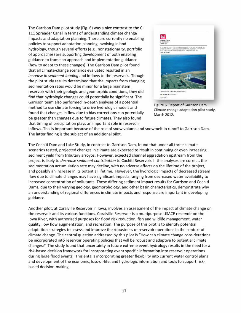
17
The Garrison Dam pilot study (Fig. 6) was a nice contrast to the C-111 Spreader Canal in terms of understanding climate change impacts and adaptation planning. There are currently no enabling policies to support adaptation planning involving inland hydrology, though several efforts (e.g., nonstationarity, portfolio of approaches) are supporting development of both enabling guidance to frame an approach and implementation guidance (how to adapt to these changes). The Garrison Dam pilot found that all climate-change scenarios evaluated resulted in an increase in sediment loading and inflows to the reservoir. Though the pilot study results determined that the impacts from changing sedimentation rates would be minor for a large mainstem reservoir with their geologic and geomorphic conditions, they did find that hydrologic changes could potentially be significant. The Garrison team also performed in-depth analyses of a potential method to use climate forcing to drive hydrologic models and found that changes in flow due to bias corrections can potentially be greater than changes due to future climates. They also found that timing of precipitation plays an important role in reservoir inflows. This is important because of the role of snow volume and snowmelt in runoff to Garrison Dam. The latter finding is the subject of an additional pilot. The Cochiti Dam and Lake Study, in contrast to Garrison Dam, found that under all three climate scenarios tested, projected changes in climate are expected to result in continuing or even increasing sediment yield from tributary arroyos. However, expected channel aggradation upstream from the project is likely to decrease sediment contribution to Cochiti Reservoir. If the analyses are correct, the sedimentation accumulation rate may decline, with no adverse effects on the lifetime of the project, and possibly an increase in its potential lifetime. However, the hydrologic impacts of decreased stream flow due to climate changes may have significant impacts ranging from decreased water availability to increased concentration of pollutants. These differing sediment impact results for Garrison and Cochiti Dams, due to their varying geology, geomorphology, and other basin characteristics, demonstrate why an understanding of regional differences in climate impacts and response are important in developing guidance. Another pilot, at Coralville Reservoir in Iowa, involves an assessment of the impact of climate change on the reservoir and its various functions. Coralville Reservoir is a multipurpose USACE reservoir on the Iowa River, with authorized purposes for flood risk reduction, fish and wildlife management, water quality, low flow augmentation, and recreation. The purpose of this pilot is to identify potential adaptation strategies to assess and improve the robustness of reservoir operations in the context of climate change. The central question addressed by this pilot is “How can climate change considerations be incorporated into reservoir operating policies that will be robust and adaptive to potential climate changes?” The study found that uncertainty in future extreme event hydrology results in the need for a risk-based decision framework for incorporating event specific information into reservoir operations during large flood events. This entails incorporating greater flexibility into current water control plans and development of the economic, loss-of-life, and hydrologic information and tools to support risk-based decision-making.
Figure 6. Report of Garrison Dam Climate change adaptation pilot study, March 2012.

18
3.3.1.1. Lessons Learned
The most important lesson learned to date from the pilot studies is an outgrowth of the contrasting experiences of the C-111 Spreader Canal and. Garrison Dam study teams. In the first case, enabling policy in the form of specified sea-level change scenarios allowed the study team to rapidly identify impacts and consider adaptation questions. This enabling policy could guide development of implementing policy to help the team through the process of formulating and comparing adaptation alternatives. In the Garrison Dam case, there is no USACE enabling guidance, or even interagency best practices around evaluating hydrologic impacts of climate change. As a result, the Garrison study team required more time and effort, including a potential false start, before developing a method appropriate to answering the central questions of the study. The lesson here is that establishing a policy, no matter how broad, reduces the time and cost of adaptation. This is because policy not only provides legal and technical justification, but it narrows the range of potential alternative and can guide planning and study approached to support the desired decisions. Based on this lesson-learned, USACE is working hard to develop both enabling (how to we frame the approach, e.g., we must evaluate these sea-level change scenarios) and implementing (e.g., how we adapt to these sea-level change scenarios) policies and guidance for adaptation. We also found that adaptation requires best available – and actionable science –, not simply the best available science. This is important because science alone is not determinative for policy. There is a gap between science and application that must be addressed in policy. Fortunately, engineers are ideally positioned to translate and science into practice. We found that we have enough science now to develop initial adaptation policy and guidance, and that close coupling of engineering to science speeds development of policy and guidance. A third import factor identified in our pilots is that costs and benefits are dynamic and will change over time, just as climate does. We may need to look at regional benefits or quantify changing benefits. Consideration of dynamic changes over time can guide adaptive management decisions. The USACE district pilot leads appreciate the CEQ framework’s questions-based approach, because it helps define levels of effort tied to the consequence and scale of the decision being made. Through these pilots, we also learned several other lessons that are helping us to improve our understanding of adaptation and of the policies and guidance that will help us mainstream adaptation. We found that local or project-level application of the proposed flexible framework often concentrates on one or two aspects of the framework. The CEQ adaptation framework is adaptable and general enough to be applied to new or existing projects at any step in the framework. Development and use of consistent national and regional climate scenarios is critical to support local or project level implementation of the framework. Time and cost to study climate impacts and apply them to mission and operations could be orders of magnitude higher than for agency-level planning depending on the level of effort (which should be scaled to consequences) and the existence or lack of policy. And also, we found that additional time is needed for implementing adaptation options that involve stakeholder collaboration, engineering and design, construction, permitting, and environmental impact assessments.
3.3.1.2. Additional Pilot Studies
Additional pilot studies were added during FY11 (see inset box) with more specific direction to test the risk-informed decision making framework, the sea-level change adaptation guidance under way (see Section 3.4.1.2, Policy and Guidance for Sea-Level Change), and lessons from our work addressing nonstationarity. The pilot teams were encouraged to use approaches such as IWRM, regional collaboration with stakeholders, and joint work with other entities. Another pilot project is also
19
underway in partnership with the USACE Portfolio Assessment for Reallocations. This pilot, conducted by the Tulsa District, is addressing climate impacts on water supply in Marion Reservoir, Kansas.
Additional Climate Change Adaptation Pilot Studies Added in FY11:
Climate Change Impact Evaluation of Mountain Snowpack – Accumulation and Runoff [Northwest Division]
East Rockaway Inlet to Rockaway Inlet, NY Collaboration Framework Development [New York District]
Formulating Climate Change Mitigation/Adaptation Strategies through Regional Collaboration with the Ohio River Basin Alliance [Huntington District]
Upland Sediment Production and Delivery in the Great Lakes Region under Climate Change [Detroit District]
Red River of the North Flooding at Fargo, ND [St. Paul District]
Developing a Framework for Incorporating Climate Change and Building Resiliency into Restoration Planning Case Study – Lower Columbia River Estuary [Portland District]
Applying Risk Informed Decision-Making Framework for Climate Change to Integrated Water Resource Management (IRWM) Planning – West Maui Watershed Project [Honolulu District]
Risk Informed Decision Making for Potential Sea-Level Rise Impacts on Hamilton Wetland Restoration – [San Francisco District]
Utilization of Regional Climate Science Programs in Reservoir and Watershed Risk-Based Impact Assessments for Oologah Lake, Oklahoma [Tulsa District]
Collaborative Relationships and Modeling to Assess the Iowa-Cedar Watershed’s Vulnerability to Climate Change & Develop Risk-Informed Climate Change Adaptation Strategies [Rock Island District]

20
3.3.2. Identifying User Needs for Adaptation
3.3.2.1. Long-Term Water Resources
Planning Decisions
In January 2011, USACE and Reclamation published the report, Addressing Climate Change in Long-Term Water Resources Planning and Management: User Needs for Improving Tools and Information20. This report (Fig. 7), builds on the needs identified in USGS Circular 1331 and is the first in a series of reports by USACE and Reclamation that identify how to improve information supporting water resources management decision-making. It seeks to focus research and technology efforts to address information and tool gaps needed for longer-term water resources planning and management. The report concluded that there are gaps in the information and tools to help water managers understand how to use climate change information to make decisions, how to assess the responses of natural systems to climate change, and how to communicate the results and uncertainties of climate change to decision-makers. A follow-on report now being prepared by science agencies will present a strategy on how to meet the identified user needs.
3.3.2.2. Short-Term Water Management
Decisions
In 2011 and 2012, CCAWWG members USACE, Reclamation, and NOAA’s National Weather Service (NWS) drafted a report about user needs for weather and climate information for short-term water management decisions. This report (Short-Term Water Management Decisions: Use Needs for Improved Climate, Weather, and Hydrologic Information21, Fig. 8)) describes short-term water management decision processes within USACE and Reclamation, including how assumptions of climate change and variability influence decisions. The draft report presents the types of monitoring and forecast information that is available from NWS and other agencies to support water resources management and discusses the characteristics and constraints on the development and use of this information. The draft report also contains a description of how information is currently used by USACE and Reclamation within its short-term water resource management
20
See http://www.ccawwg.us/index.php/activities/addressing-climate-change-in-long-term-water-resources-planning-and-management
21 See http://www.ccawwg.us/index.php/activities/short-term-water-management-decisions-user-needs-for-
improved-climate-weather-and-hydrologic-information
Figure 8. Review draft of joint USACE- Reclamation-NWS report on Short-Term Water Management Decisions: Use Needs for Improved Climate, Weather, and Hydrologic Information, May 2012.
Figure 7. Joint USACE- Reclamation report on Addressing Climate Change in Long-Term Water Resources Planning and Management: User Needs for Improving Tools and Information, January 2011.

21
activities. Ultimately, this document will help identify opportunities to improve water resources management by communicating to the broad community of information providers and the research and development communities the needs of the management agencies within the mission authorities currently available. This joint report will be published in 2012 and will be followed by a science-agency prepared report laying out a strategy to meet the user needs expressed.
3.3.3. Training to Support Adaptation
USACE is collaborating with Reclamation and the COMET training program of the University Corporation for Atmospheric Research (UCAR) to produce a series of materials to help train professionals facing questions of climate change and water resources. USACE and Reclamation expect the first modules to be tested later in 2012. These modules will be deployed for wider testing following evaluation and revision. Once completed, these training materials will be made available through UCAR’s existing remote training facilities. Among the issues identified by USACE and Reclamation as meeting high-priority user needs for climate information are these:
Determine the relevant weather and climate processes that have significant uncertainty when used in addressing hydrologic questions.
Distinguish between natural climate variability (as determined from historical data) and projected climate change manifestations.
Identify and explain issues associated with model resolution and regionalizing, especially with respect to downscaling and bias correction.
Locate relevant climate projection information and model data.
Evaluate the utility of projection information in portraying the relevant processes; describe and support the approach taken for downscaling and bias correction
Assess and communicate the uncertainty level associated with climate projections
Determine the appropriate blend of historical and climate information for use in studies addressing hydrologic questions
Select one or more hydrology models (from those available) consistent with the blending technique chosen and appropriate physical processes.
Assemble and apply the hydrology model to the location of interest (recognizing basin characteristics and historical weather/streamflow relationships).
Evaluate the model’s performance according to appropriate criteria.
Conduct simulations using identified climate change weather scenarios and blending techniques
Evaluate the relevance and quality of the simulation results.
Judge whether the simulation results are consistent with your original hypothesis.
Assess if the results are relevant to the questions being asked and the decision to be made.
Synthesize and communicate results.
3.4. Developing Policy and Guidance Framework
Our goal is to develop practical, nationally consistent, legally justifiable, and cost effective measures, both structural and nonstructural, to reduce vulnerabilities and improve the resilience of our water resources infrastructure impacted by climate change. In developing both enabling and implementing (e.g. Wilby and Keenan 2012) policy and guidance, we are taking a collaborative approach that embodies a new attitude to partnering between agencies. This collaboration takes advantage of our different perspectives and expertise, and also results in consistent guidance between agencies.
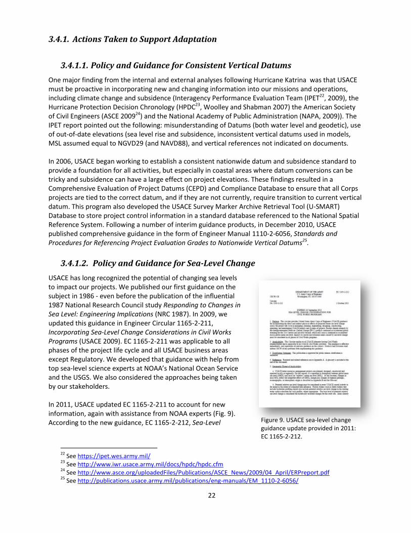
22
3.4.1. Actions Taken to Support Adaptation
3.4.1.1. Policy and Guidance for Consistent Vertical Datums
One major finding from the internal and external analyses following Hurricane Katrina was that USACE must be proactive in incorporating new and changing information into our missions and operations, including climate change and subsidence (Interagency Performance Evaluation Team (IPET22, 2009), the Hurricane Protection Decision Chronology (HPDC23, Woolley and Shabman 2007) the American Society of Civil Engineers (ASCE 200924) and the National Academy of Public Administration (NAPA, 2009)). The IPET report pointed out the following: misunderstanding of Datums (both water level and geodetic), use of out-of-date elevations (sea level rise and subsidence, inconsistent vertical datums used in models, MSL assumed equal to NGVD29 (and NAVD88), and vertical references not indicated on documents. In 2006, USACE began working to establish a consistent nationwide datum and subsidence standard to provide a foundation for all activities, but especially in coastal areas where datum conversions can be tricky and subsidence can have a large effect on project elevations. These findings resulted in a Comprehensive Evaluation of Project Datums (CEPD) and Compliance Database to ensure that all Corps projects are tied to the correct datum, and if they are not currently, require transition to current vertical datum. This program also developed the USACE Survey Marker Archive Retrieval Tool (U-SMART) Database to store project control information in a standard database referenced to the National Spatial Reference System. Following a number of interim guidance products, in December 2010, USACE published comprehensive guidance in the form of Engineer Manual 1110-2-6056, Standards and Procedures for Referencing Project Evaluation Grades to Nationwide Vertical Datums25.
3.4.1.2. Policy and Guidance for Sea-Level Change
USACE has long recognized the potential of changing sea levels to impact our projects. We published our first guidance on the subject in 1986 - even before the publication of the influential 1987 National Research Council study Responding to Changes in Sea Level: Engineering Implications (NRC 1987). In 2009, we updated this guidance in Engineer Circular 1165-2-211, Incorporating Sea-Level Change Considerations in Civil Works Programs (USACE 2009). EC 1165-2-211 was applicable to all phases of the project life cycle and all USACE business areas except Regulatory. We developed that guidance with help from top sea-level science experts at NOAA’s National Ocean Service and the USGS. We also considered the approaches being taken by our stakeholders. In 2011, USACE updated EC 1165-2-211 to account for new information, again with assistance from NOAA experts (Fig. 9). According to the new guidance, EC 1165-2-212, Sea-Level
22
See https://ipet.wes.army.mil/ 23
See http://www.iwr.usace.army.mil/docs/hpdc/hpdc.cfm 24
See http://www.asce.org/uploadedFiles/Publications/ASCE_News/2009/04_April/ERPreport.pdf 25
See http://publications.usace.army.mil/publications/eng-manuals/EM_1110-2-6056/
Figure 9. USACE sea-level change guidance update provided in 2011: EC 1165-2-212.

23
Change Considerations for Civil Works Programs26, potential relative sea-level change must be considered in every USACE coastal activity as far inland as the extent of estimated tidal influence. Fluvial studies (such as flood studies) that include backwater profiling should also include potential relative sea-level change in the starting water surface elevation for such profiles, where appropriate. The approach taken in EC 1165-2-212 incorporates new information from key workshops and scientific publications. The guidance is used not only throughout USACE, but by other agencies as well, including the State of Florida27. A web-based tool enables users of the guidance to develop the three required scenarios at appropriate NOAA tide gauges28. In March 2012, the release of a report by Climate Central called Surging Seas29 generated quite a bit of media attention. The report was cited by newspapers from New York to Florida, and was the focus of National Public Radio’s "On Point30." Host Tom Ashbrook and lead author Ben Strauss discussed sea-level change around the US. USACE was specifically called out by Skip Stiles of Wetland Watch as the only Federal agency with sea-level change guidance. Other callers urged local state and federal agencies to communicate the risks. The Surging Seas report and interactive web site are based on two journal papers in the March 2012 issue of Environmental Research letters31, the second of which cites EC 1165-2-212 as an example of policy supporting adaptation planning.
3.4.1.3. New Guidance Series
USACE established a new guidance series beginning 31 December 2011: Series 1100, Global Changes32. The new guidance series recognizes that global changes, including demographic shifts, changing land use, climate change, sea-level variability, increasing State capabilities, aging infrastructure, disappearing wetlands, water availability, and changing social values and economic considerations, represent a new set of challenges that USACE must be prepared for. The description of the new guidance series notes that “Systems based approaches and risk-informed decision making throughout the project life cycle (planning, engineering and operations) are essential. Global challenges will be addressed in a transparent, collaborative environment where public safety is held paramount and natural ecosystems are valued.”
3.4.2. Ongoing Actions to Support Adaptation
3.4.2.1. Guidance on Adapting to Sea-Level Change
The USACE sea-level change enabling policy provides scenarios against which USACE projects and programs can be assessed, but does not provide specific implementation guidance to adapt to the potential future sea levels expected. Sea-level change adaptation implementing guidance is the focus of an interagency and international team developing a USACE Engineering Technical Letter (ETL) in the
26
See http://publications.usace.army.mil/publications/eng-circulars/EC_1165-2-212.pdf 27
See http://www.dot.state.fl.us/research-center/Completed_Proj/Summary_PL/FDOT_BDK79_977-01_rpt.pdf
28 See http://www.corpsclimate.us/ccaceslcurves.cfm
29 See the executive summary at http://sealevel.climatecentral.org/research/reports/surging-seas/
30 See http://onpoint.wbur.org/2012/03/19/rising-tides
31 See http://iopscience.iop.org/1748-9326/7/1, “Modelling sea level rise impacts on storm surges along US
coasts” by Tebaldi et al and “Tidally adjusted estimates of topographic vulnerability to sea level rise and flooding for the contiguous United States” by Strauss et al.
32 USACE Office Memorandum OM 25-1-51, Guidance for Preparation and Processing of USACE Command
Publications within HQUSACE, see http://publications.usace.army.mil/publications/index.html.

24
Global Change Series (1100): Procedures to Evaluate Sea Level Change, Impacts, Responses, and Adaptation. The key issues that climate change poses for the USACE are in many ways common to all infrastructure agencies and organizations. Therefore, this guidance recognizes the essential role of collaboration with other federal agencies and our state and community partners is recognized, as is the development of outputs necessary to meet external review, stakeholder, and USACE expectations. The expert team includes representatives from USACE districts, divisions, labs, and centers, and also from NOAA, USGS, Reclamation, Navy, Coast Guard, FHWA, FEMA, National Park Service, US Naval Academy, HR Wallingford (UK), University of Southampton (UK), and Moffat and Nichol Engineers. This collaborative process supports rapid incorporation of new and changing information and provides rapid knowledge transfer between agencies. The team is developing implementing guidance that addresses the process of adaptation. This includes the development of thresholds and tipping points to guide adaptive, flexible adaptation and detailed implementation guidance on how to include sea-level change impacts and adaptation into USACE planning, engineering, construction, operation, and maintenance. The guidance integrates the recommended planning and engineering approach at the regional and project level necessary for understanding and adapting to impacts of projected sea-level change. A hierarchy of decisions supports an appropriate level of analysis. Key decision matrix concepts address sustainability, resilience, adaptive and anticipatory planning, and system and cumulative effects. Review is expected to take place during late summer 2011, with publication either at the end of 2012 or early in 2013.
3.4.2.2. Guidance on Appropriate Use of Paleoflood Information
The uncertainty associated with future climate provides an opportunity to utilize information from the very distant past to help frame characteristics of flood possibilities. This must be done in a manner that is consistent with USACE mission and goals as well as with considerations for the underlying assumptions associated with paleoflood information. Therefore, USACE is developing an enabling policy in the form of an Engineering Technical Letter (ETL) in the Global Change Series (1100) (Appropriate Application of Paleoflood Hydrology for Civil Works Programs). The guidance discusses how paleoflood hydrology methods are relevant to USACE design and operations, including decisions such as estimating flood peak magnitudes, volumes and durations for flood damage assessments, or evaluating design criteria using the minimum essential guidelines. A white paper that supports the development of this guidance is currently under review by a panel of independent external experts. The guidance is expected to be published in early 2013.
3.4.2.3. Climate Change and Inland Hydrology Guidance
Incorporating climate change considerations within our wide array of inland hydrology guidance is a priority action for USACE. Beginning in 2012 and continuing in 2013, we are developing an overarching enabling guidance document to address climate impacts to the hydrologic aspects of USACE projects and programs. This guidance builds on the core principles of scalable frameworks and scenarios to enable assessments of future project performance against the uncertainties of climate change. The scalable framework requires differing amounts and types of information, level of detail, and complexity of analyses depending on the questions being asked on a case-by-case basis (e.g., there are no “one size fits all” approaches). The scenario approach provides a range of plausible future outcomes against which project performance can be assessed.
25
4. Summary and Conclusions
The US Army Corps of Engineers (USACE) understands that climate change is among the major challenges of the 21st century, and can impact all areas of our missions and operations. For more than five years now, we have made progress on a comprehensive approach to climate change that incorporates new knowledge and changing conditions about vulnerabilities, risks and opportunities into our missions, operations, programs, and projects. Our approach enhances the capacity of our planning, design, construction, operations, and maintenance to adapt to changing climate and other global changes. Our goal is to develop practical, nationally consistent, legally justifiable, and cost effective measures, both structural and nonstructural, to reduce vulnerabilities and improve the resilience of our water resources infrastructure impacted by climate change. We are taking a collaborative approach that takes advantage of different perspectives and expertise so that our progress on adaptation reflects the best available and actionable science. But in turn, we are working to help guide the science to better meet our needs and the needs of other land and water resources agencies. This USACE Climate Change Adaptation Plan provides the information requested by the Council on Environmental Quality in their Implementing Instructions for Federal Agency Climate Change Adaptation issued on 4 March 2011 and the 29 February 2012 statement on Preparing Federal Agency Climate Change Adaptation Plans In Accordance with Executive Order 13514. We believe that this 2012 USACE Adaptation Plan and Report, prepared at the direction of the USACE Adaptation Steering Committee, demonstrates a broad understanding of the challenges posed by climate change to our mission, programs, and operations, and a commitment to undertake specific actions in FY 2013 and beyond to better understand and address those risks and opportunities. We present information about how we plan and evaluate agency adaptation planning, describe programmatic activities supporting climate change adaptation, and describe efforts to both better understand and to address climate change risks and opportunities. We are pilot-testing adaptation methods, sharing lessons learned within and outside the agency, and refining our adaptation based on the new knowledge. Working within a risk-informed framework that considers all of the challenges facing us will enable USACE to implement integrated water resources management solutions to the impacts of climate change. This report also provides additional information on current USACE adaptation planning and implementation progress. The scope, collaboration, and resources we have applied to understand climate change and make progress on adaptation planning and implementation. Our work demonstrates the importance we place on this critical challenge to the long-term sustainability of our mission, operations, programs and projects, which oversee and administer public water resources and associated infrastructure in every state, as well as several international river basins, and support military operations worldwide that promote peace and stability.

26
5. References
Brekke, L., J.E. Kiang, J.R. Olsen, D.R. Pulwarty, D. Raff, D.P. Turnipseed, R.S. Webb, and K.D. White (2009) Climate change and water resources management: A federal perspective. USGS Circular 1331. Available at http://pubs.usgs.gov/circ/1331/. Brekke, L., K.D. White, J.R. Olsen, E.S. Townsley, D. Williams, F. Hanbali, C. Hennig, C. Brown, D. Raff, and R. Wittler, R. (2011) Addressing Climate Change in Long-Term Water Resources Management: User Priorities for Improving Tools and Information. U.S. Army Corps of Engineers Civil Works Technical Series CWTS-10-02, 161 p. Available at http://www.ccawwg.us/index.php/activities/addressing-climate-change-in-long-term-water-resources-planning-and-management. Council on Environmental Quality (2010) Progress Report of the Interagency Climate Change Adaptation Task Force: Recommended Actions in Support of a National Climate Change Adaptation Strategy: October 5, 2010. White House Council on Environmental Quality: Washington, DC. Available at http://www.whitehouse.gov/sites/default/files/microsites/ceq/Interagency-Climate-Change-Adaptation-Progress-Report.pdf Council on Environmental Quality (2011) Federal Agency Climate Change Adaptation Planning Support Document. White House Council on Environmental Quality: Washington, DC. Available at http://www.whitehouse.gov/sites/default/files/microsites/ceq/adaptation_support_document_3_3.pdf Council on Environmental Quality and Office of Management and Budget (2011) Implementing Instructions for Federal Agency Climate Change Adaptation. White House Council on Environmental Quality: Washington, DC. Available at http://www.whitehouse.gov/sites/default/files/microsites/ceq/adaptation_final_implementing_instructions_3_3.pdf Interagency Climate Change Adaptation Task Force (2011) National Action plan: Priorities for Managing Freshwater Resources in a Changing Climate. Available at http://www.whitehouse.gov/sites/default/files/microsites/ceq/2011_national_action_plan.pdf Interagency Performance Evaluation Team (2009) Performance Evaluation of the New Orleans and Southeast Louisiana Hurricane Protection System Final Report of the Interagency Performance Evaluation Task Force. US Army Corps of Engineers: Washington DC. Available at: https://ipet.wes.army.mil/. Kiang, J.E, J.R. Olsen, and R.M. Waskom (2011) “Introduction to the featured collection on ‘Nonstationarity, Hydrologic Frequency Analysis, and Water Management.’” JAWRA, (47)3: 433-435. Kundzewicz, Z.W., L.B. Mata, N.W. Arnell, P. Doll, B. Jiminez, K. Miller, T. Oki, Z. Sen, and I. Shiklomanov (2008) “The implications of projected climate change for freshwater resources and their management.” Hydrological Sciences Journal 53(1) 3-10. National Academy of Public Administration (NAPA) (2007) Prioritizing America’s Water Resources Investments: Budget Reform for Civil Works Constructions Projects at the US Army Corps of Engineers. National Academy of Public Administration: Washington, DC.
27
National Research Council (1987) Responding to Changes in Sea Level: Engineering Implications. National Academy Press: Washington, DC. Available at http://www.nap.edu/catalog.php?record_id=1006 Short, M.D., W.L. Peirson, G.M. Peters and R.J. Cox (2012) “Managing Adaptation of Urban Water Systems in a Changing Climate.” Water Resources Management 26(7) 1953-1981. DOI: 10.1007/s11269-012-0002-8 Stockton, S.L. and K.D. White (2011) “U.S. Army Corps of Engineers’ Collaborative Approach to Twenty-First Century Challenges Posed by Global Change.” Chapter 3 IN Global Change and Local Adaptation. p. 19-35 Springer: Netherlands. US Army Corps of Engineers (2010) National Report: Responding to National Water Resources Challenges. US Army Corps of Engineers. Available at http://www.building-collaboration-for-water.org/ US Army Corps of Engineers (2011) Sustainable Solutions to America’s Water Resources Needs. Department of the Army, Corps of Engineers, Civil Works Strategic Plan 2011-2015. (May 2011). Wilby, R.L. and R. Keenan (2012) “Adapting to flood risk under climate change.” Progress in Physical Geography, 36 (3) 348-378. DOI: 10.1177/0309133312438908 Woolley, D. and L. Shabman (2007) Hurricane Protection Decision Chronology (HPDC) Report: Decision Chronology for the Lake Pontchartrain & Vicinity Hurricane Protection Project, A Report for the Headquarters, U.S. Army USACE, Submitted to the U.S. Army USACE Institute for Water Resources http://www.iwr.usace.army.mil/inside/products/pub/hpdc/hpdc.cfm

A-1
APPENDIX A: Excerpts from High-Level Vulnerability Analysis
On 31 March 2012, the Assistant Secretary of the Army for Civil Works, Ms. Jo-Ellen Darcy, submitted letters to CEQ and to OMB stating that a high-level vulnerability analysis to the impacts of climate change had been submitted as requested by them in their Implementing Instructions for Federal Agency Climate Change Adaptation issued on 4 March 2011. The high-level analyses were specifically NOT intended to be detailed vulnerability assessments of specific programs, projects, or geographic regions. Rather, they were to serve as a tool for agencies that would provide initial awareness of potential climate change impacts to agency operations, policies and programs, to guide agency priorities. This Appendix to the USACE 2012 Adaptation Plan and Report contains excerpts of the high-level vulnerability analysis at a level of detail and understanding that also meets the requirements of the 29 February 2012 statement on Preparing Federal Agency Climate Change Adaptation Plans In Accordance with Executive Order 13514. Potential water resources management sector impacts identified and discussed in USGS Circular 1331 include changing water availability, variability, demand, and quality; wild-land fires; ecosystem or species transitions or alterations; coastal and estuarine conditions; and energy production and demand. NRC (2010) provided a comprehensive list of climate changes and their associated impacts to ecosystems, based on a wide variety of sources. For the purpose of the high-level vulnerability analysis, we have outlined potential climate change impacts associated with the drivers discussed above that could impact the selected USACE business areas of Navigation, Flood and Coastal Storm Damage Reduction, Environment, Hydropower, Regulatory, Recreation, Emergency Management, and Water Supply. These impacts are shown in Table 1, along with the business areas they are expected to impact.
Table 1. Climate Change Impacts to Selected Strategic Missions and Goals (after NRC 2010).
Climate Change
Impact
Impacts: Positive (+), Negative (-),
or Both
Primary Mission/Goal
Impacted*
Increasing average air temperature
Change in form of precipitation (snow vs. rain) +, - N, F, ER, H, RC, W
Changes in water temperatures → water quality, lake stratification
- ER, RC
Effects on crops and growing season → changing water demand
+, - H, W
Changes in ecosystem structure and function - ER, RG, RC
Changes in invasive species or pest distribution +, - N, F, ER, H, RC, W,
RG
Changes in river ice regimes +, - N, F, ER, H, EM, RC
Changes to glacial processes - N, F, ER, EM
Changes to ocean ice regimes +, - N, F, ER, EM
* Note: there may be secondary and/or tertiary impacts. For example, effects on crops and growing season are shown as
potentially leading to changing water demand, but they may also affect our navigation mission if exports change and if supplies to growing areas change. N=Navigation, F=Flood and Coastal Storm Damage Reduction, ER=Ecosystem Restoration, H=Hydropower, RG=Regulatory, RC=Recreation, EM=Emergency Management, W=Water Supply

A-2
Climate Change
Impact
Impacts: Positive (+), Negative (-),
or Both
Primary Mission/Goal
Impacted*
Changes to permafrost - ER, RG
Changes in energy demand - N, ER, H, W, RG
Altered ocean circulation → changing tide & surge regimes - N, F, ER, EM, RG
Increased extreme events → heat/cold waves, ice/dust storms, blizzards
- N, F, ER, H,EM, W
Changing persistence of large-scale atmospheric features +, - N, F, ER, H, EM, W
Changes in evapotranspiration - N, ER, H, W, RC
Changing precipitation: increasing variability, altered seasonality, and changing intensity or frequency of extremes (flood and drought)
Changing or more variable municipal & industrial water supplies
+, - N, W, RG
More variable stream flow and lake levels +, - N, F, ER, H, RC,
EM,W, RG
Changing water conditions for ecosystems +, - N, ER, H, RG, RC, W
Changing frequency of coastal and riverine flooding +, - N, F, ER, EM, H, W
Changes in stormwater runoff - N, F, ER, RC, W, RG
Changes in drought frequency and intensity - N, F, ER, H, RG, RC,
W
Changing sediment regimes +, - N, F, ER, H, RC, W
Changing levels of pollutants in runoff +, - ER, W, RC
Changes in snowmelt onset and volume +, - N, F, ER, H, RC, EM,
W
Sea-level and costal storm changes and associated tides, waves, and surges
Increased shoreline erosion and changes to barrier islands & inlets
- N, F, ER, RG
Loss of or changes to coastal wetlands +, - N, F, ER, RG
Increased storm waves, surges, tides - N, F, ER, EM
Changes in estuarine structure and processes +, - N, F, ER
Altered saline intrusion into coastal aquifers - ER, W
Inundation of low-lying land +, - N, F, ER, RG, EM
Increased depth in harbors and channels +, - N, F, ER, RG
Altered coastal sedimentation +, - N, F, ER, RG
Changes in wind regimes +, - N, F, ER
Changes in ecosystem structure and species distributions, including invasive species and pests
+, - ER, RG, RC
Altered frequency & extent of harmful algal blooms & coastal hypoxia
- ER, RC
In keeping with the questions-based approach of the flexible framework for climate change adaptation
(CEQ 2010, CEQ 2011), this high-level vulnerability analysis also poses priority questions to guide
adaptation implementation planning. Specific questions posed by CEQ (2010) to agencies beginning
adaptation planning —and USACE responses to them — include the following:
• What aspects of the climate are changing, at what rates, and over what spatial scale (i.e., at
the global, national, regional, and local level)? As a water resources agency, USACE
recognizes that changes in temperature and precipitation, the fundamental drivers of the
hydrologic cycle, are changing at different – and variable – rates, at all scales, from local to
global.

A-3
• What uncertainties are associated with the projected impacts of climate change? The
primary uncertainties affecting USACE are nonstationarity (due to climate and other global
changes) and increasing climate variability.
• How do these compare and relate to other stresses and their uncertainties? Other global
changes, especially land use and land cover changes, may outweigh climate change impacts
in the near- and mid-term. However, because our water resources infrastructure (both built
and natural) is long-lived, climate and other global changes should be incorporated in all
phases of the project life-cycle. The uncertainties associated with other stressors are equal
to or less than climate uncertainties, depending on the decision scale.
• How can we characterize and use this uncertainty in our adaptation efforts? USACE is
currently exploring nonstationarity issues with other water resources agencies.
Uncertainties arising from the selection of analytical processes and methods for use of
climate change information in decision-making are also under study by water resources
agencies. USACE is also conducting pilot tests to identify uncertainties, whether in climate
projections or in systems responses.
Table 2 contains some of the more detailed priority questions facing USACE as we began to manage
climate change impacts, organized by business line.
Table 3 presents additional questions, directed at the functional areas important in the USACE, which
integrate across the business lines.
Table 2. Priority Questions Driving USACE Approach to Manage Climate Change.
Priority Questions
Driving
USACE Approach
Business Line
Impacted*
How These Questions Relate to Business Areas
How do we respond
to increasing
variability of
precipitation with
climate change?
N, F, ER, H, RC,
EM, W
Increasing variability impacts our capacity to:
Provide navigation services
Manage reservoirs as authorized to provide flood risk reduction,
and prepare, respond and recover from floods and coastal storms
Effectively plan, design, and manage ecosystem restoration
projects
Provide reliable hydropower
Manage reservoirs for recreation and authorized water supply
These impacts may be positive or negative, depending on local
conditions. For example, a summer season with greater than normal
precipitation (but no increase in flood flows) could enhance navigation,
hydropower, recreation, and water supply. On the other hand, a
winter season with less snow or rain, could improve spring flood risks
but decrease summer water supply availability. The competing
objectives of flood risk management and water supply could become
more difficult to manage
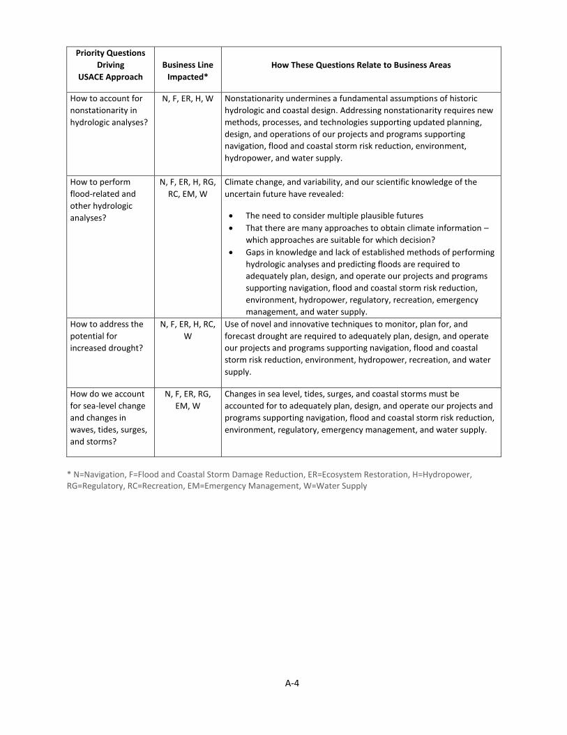
A-4
Priority Questions
Driving
USACE Approach
Business Line
Impacted*
How These Questions Relate to Business Areas
How to account for
nonstationarity in
hydrologic analyses?
N, F, ER, H, W Nonstationarity undermines a fundamental assumptions of historic
hydrologic and coastal design. Addressing nonstationarity requires new
methods, processes, and technologies supporting updated planning,
design, and operations of our projects and programs supporting
navigation, flood and coastal storm risk reduction, environment,
hydropower, and water supply.
How to perform
flood-related and
other hydrologic
analyses?
N, F, ER, H, RG,
RC, EM, W
Climate change, and variability, and our scientific knowledge of the
uncertain future have revealed:
The need to consider multiple plausible futures
That there are many approaches to obtain climate information –
which approaches are suitable for which decision?
Gaps in knowledge and lack of established methods of performing
hydrologic analyses and predicting floods are required to
adequately plan, design, and operate our projects and programs
supporting navigation, flood and coastal storm risk reduction,
environment, hydropower, regulatory, recreation, emergency
management, and water supply.
How to address the
potential for
increased drought?
N, F, ER, H, RC,
W
Use of novel and innovative techniques to monitor, plan for, and
forecast drought are required to adequately plan, design, and operate
our projects and programs supporting navigation, flood and coastal
storm risk reduction, environment, hydropower, recreation, and water
supply.
How do we account
for sea-level change
and changes in
waves, tides, surges,
and storms?
N, F, ER, RG,
EM, W
Changes in sea level, tides, surges, and coastal storms must be
accounted for to adequately plan, design, and operate our projects and
programs supporting navigation, flood and coastal storm risk reduction,
environment, regulatory, emergency management, and water supply.
* N=Navigation, F=Flood and Coastal Storm Damage Reduction, ER=Ecosystem Restoration, H=Hydropower, RG=Regulatory, RC=Recreation, EM=Emergency Management, W=Water Supply

A-5
Table 3. Focus Questions for Climate Change and Variability by USACE Functional Areas
Functional Area
Focal Point Impacts to Consider
Planning/ Policy
Planning transformation means more focused studies performed more quickly
How will we include climate change in a way that does not add time and cost to studies already struggling to meet new requirements? How do we improve our understanding of the future without-project conditions? What are the opportunities we can identify in planning? How do we consider a broad enough range of future conditions to support project formulation that supports the project life-cycle and at the same time provide specific information for final decision making?
Programs/ Project Management
Budget transformation: do fewer things better while funding and prioritizing actions in the Nation’s interest
How will considering and mainstreaming climate variability and change impact ongoing budget and schedules? How and when will climate change affect budget priorities? How can we plan for the future actions in the Nation’s interest (what are they, and when do we need to be ready for them)? What does this mean to recapitalization? Are there opportunities we can capitalize on?
E&C
Robust engineering, design, water management that consider future conditions, including impacts to cost and schedule during construction
What do we know now about climate variability and change that should be included in dam safety and levee safety guidance underway? Where and how are our water control operations sensitive to climate change? Do we know enough to develop new design guidance for hydrology? When, where, and how do we expect climate variability and change to impact project designs? Decreased cold periods may enhance construction scheduling, while increased hot periods may result in delays. How can we identify and enhance opportunities? How do we integrate adaptation and mitigation in a way that recognizes the primacy of our CW missions and operations?
O&M
Sustainable O&M to meet the mission, jointly protecting aquatic resources and reasonable development under future conditions
How can we consider and mainstream climate variability and change to enhance our asset management program? How will climate change impact our recreation and natural resources management operations? How will climate change impact the Regulatory program? What types of impacts or benefits can be expected in the environmental stewardship program? How will climate change impact hydropower? Can we expect increased (or decreased) maintenance costs because of changing climate? Are there other opportunities associated with climate variability and change?

A-6
Functional Area
Focal Point Impacts to Consider
Emergency Management
Continued emphasis on flood risk management and the solutions we shape
Where are we most vulnerable to intense rainfall or sudden snowmelt? Are there areas where changes in snow will decrease the need for spring emergency management? How do climate variability and change impact preparedness? Are there opportunities that can be exploited? How can we include climate change in a way that benefits our nonstructural designs and standards? How will climate change impact response and recovery, particularly in coastal areas already subject to isolation due to storm events? How do we work with other agencies to understand and communicate climate impacts to residual risk?