Embed Size (px)
Citation preview

The Road Inventoryof
Chaco Culture National Historical ParkCHCU – 7400
Cycle 4
Prepared By: Federal Highway Administration Road Inventory Program Cycle 4

[_[_
[_
Chaco Culture National Historical Parkin
New Mexico
Chaco CultureNational Historical Park
Santa Fe
Albuquerque
El Paso
M e x i c oM e x i c o

TABLE OF CONTENTS
SECTION PAGE
1. INTRODUCTION 1 - 1
2. PARK SUMMARY INFORMATION Paved Route Miles and Percentages by Functional Class and PCR 2 – 1 ARAN Road Condition Summary 2 – 2 Parkwide Condition Summary 2 – 3 Cycle 2 vs Cycle 3 vs Cycle 4 Condition Comparisons 2 – 4
3. PARK ROUTE LOCATION / CONDITION MAPS
Route Location Key Map 3 – 1 Route Location Area Map 3 – 2 Route Condition Key Map – PCR Mile by Mile 3 – 3 Route Condition Area Map – PCR Mile by Mile 3 – 4
4. PARK ROUTE INVENTORY
Route Identification Report 4 – 1
5. PAVED ROUTE CONDITION RATING SHEETS (CRS) CRS Pages 5 – 1
6. MANUALLY RATED PAVED ROUTE CONDITION RATING SHEETS (MRR) MRR Pages 6 – 1
7. PARKING AREA CONDITION RATING SHEETS
Paved Parking Area Pages 7 – 1
8. PARKWIDE / ROUTE MAINTENANCE FEATURES SUMMARIES Parkwide Maintenance Features Summary 8 – 1 Route Maintenance Features Summary 8 – 2 Structure List 8 – 3
9. PARK ROUTE MAINTENANCE FEATURES ROAD LOGS
Route Maintenance Features Road Logs 9 – 1
10. APPENDIX A. Glossary of Terms and Abbreviations 10 – 1 B. Description of Rating System 10 – 2 C. General Information on RIP Systems 10 – 8 D. Metadata 10 – 11

Chaco Culture National Historical Park
Section 1 Introduction

INTRODUCTION
Background: In 1976, the National Park Service (NPS) and the Federal Highway Administration (FHWA) entered into a Memorandum of Agreement(MOA), establishing the Road Inventory Program (RIP). In 1980, the NPS and the FHWA terminated the 1976 MOA and entered into a new MOA that provided for the completion of the initial phase of the RIP. The purpose of the RIP, per the 1980 MOA was to maintain and update RIP data in order to develop long-range costs and programs to bring National Park Service (NPS) roads up to, or to maintain, designated standards, and establish a maintenance managementprogram.
The FHWA’s Federal Lands Highway (FLH) was assigned the task of identifying condition deficiencies and corrective priorities along with associated corrective costs, inventorying maintenance features (e.g., culverts, signs, guardrail, etc.), summarizing the data and findings in a report and providing a photographic record of the road system.
The FLH completed the initial phase of the RIP in the early 1980’s. As a result of this effort, each park received a RIP book, also known as the “Brown Book,” that included the information collected during this initial RIP phase.
In an effort to maintain and update the RIP data, a cyclical data collection and reporting process was reestablished in the 1990’s. The FLH completed two cycles of RIP data collection between 1994 and 2001. Cycle 1 was collected in 44 large parks from 1994 to 1996. This data was found to be unusable for comparison to future cycles. Cycle 2 data was collected from March 1997 to January 2001 in 79 large parks and 5 small parks containing 4,874 route miles.Each park received a copy of a Cycle 2 RIP Report, also known as the “Blue Book”. Cycle 3 was completed from 2001 through 2004, and included data collection in all parks that contain pavement.
Since 1984, the RIP Program has been funded through the Federal Lands Highway Program’s Park Roads and Parkways (PRP) Program. Currently, the NPS Washington Headquarters’ Park Facility Management Division is responsible for coordinating the RIP program with the FLH. The FLH Washington office coordinates policy and prepares national reports and needsassessment studies for congress.
In 1998, the Transportation Equity Act for the 21st Century (TEA-21) amendedTitle 23 U.S.C., and inserted Section 204(a)(6) which requires the Federal Highway Administration and the National Park Service, to develop, by rule, a Pavement Management System (PMS) for the park roads and parkways serving the National Park System. As a result of the requirements in TEA-21, the NPS and FHWA are in the process of developing a PMS. The PMS will assist thedecision-makers in effectively spending limited PRP Program funds. The PMS
1 - 1
will provide information for planning and programming road maintenance,rehabilitation, and reconstruction activities. RIP data will provide the basic information for this system.
Key information included in the RIP is the mileage inventory and conditionassessments accomplished by the RIP Program. The mileage and condition dataare used in the current allocation formula of PRP Program funds.
RIP Cycle 4: Cycle 4 data collection was initiated in spring 2006, where 86 large parks, consisting of 5,553 route miles and 6,232 paved parking areas, were selected as a representative sample of the entire NPS paved road network. Cycle 4 is scheduled for completion in spring 2009 and will serve the PMS in further development of its pavement preservation techniques.
In the Cycle 4 Reports, a general condition rating of excellent, good, fair and poor is ascribed to each one-mile section of paved roadway, and to each paved parking area. This condition rating system provides a realistic means of assessing the general funding needs for road improvements. Along with these descriptive condition ratings, a numerical rating between 0 and 100 is ascribed to each mileof road and to each parking area. This numerical rating is called a PavementCondition Rating (PCR). The PCR rating system is described in Section 10 of this report.
All of the fieldwork required for obtaining inventory, condition, and maintenancefeature information is coordinated with each park and the regional offices to ensure that the information in the RIP reports is accurate.
The FLH is responsible for all the data presented in this report. Anyone having questions or comments regarding the contents of this report is encouraged to contact the FHWA RIP Coordinator. It is our aim to provide exceptional customer satisfaction in our delivery of the RIP program.
The FHWA RIP Team
FHWA/EFLHD FHWA/CFLHD21400 Ridgetop Circle 12300 West Dakota Ave. Sterling, VA 20166 Lakewood, CO 80228 (703) 404-6371 (720) 963-3560
1 - 2
Chaco Culture National Historical Park
Section 2 Park Summary Information

CHCU: PAVED ROUTE MILES AND PERCENTAGES BY FUNCTIONAL CLASS AND PCR
Pavement Condition Rating (PCR) Poor (<=60) Fair (61-84) Good (85-94) Excellent (95-100) TOTAL
F.C. MILES % MILES % MILES % MILES % MILES1 0.41 3.69% 2.16 19.42% 0.14 1.26% 2.712 0.41 3.69% 0.21 1.89% 0.623 1.54 13.85% 5.62 50.54% 0.28 2.52% 7.4445 0.19 1.71% 0.16 1.44% 0.35678
Totals 2.55 22.93% 8.15 73.29% 0.42 3.78% 0.00 0.00% 11.12
2-1
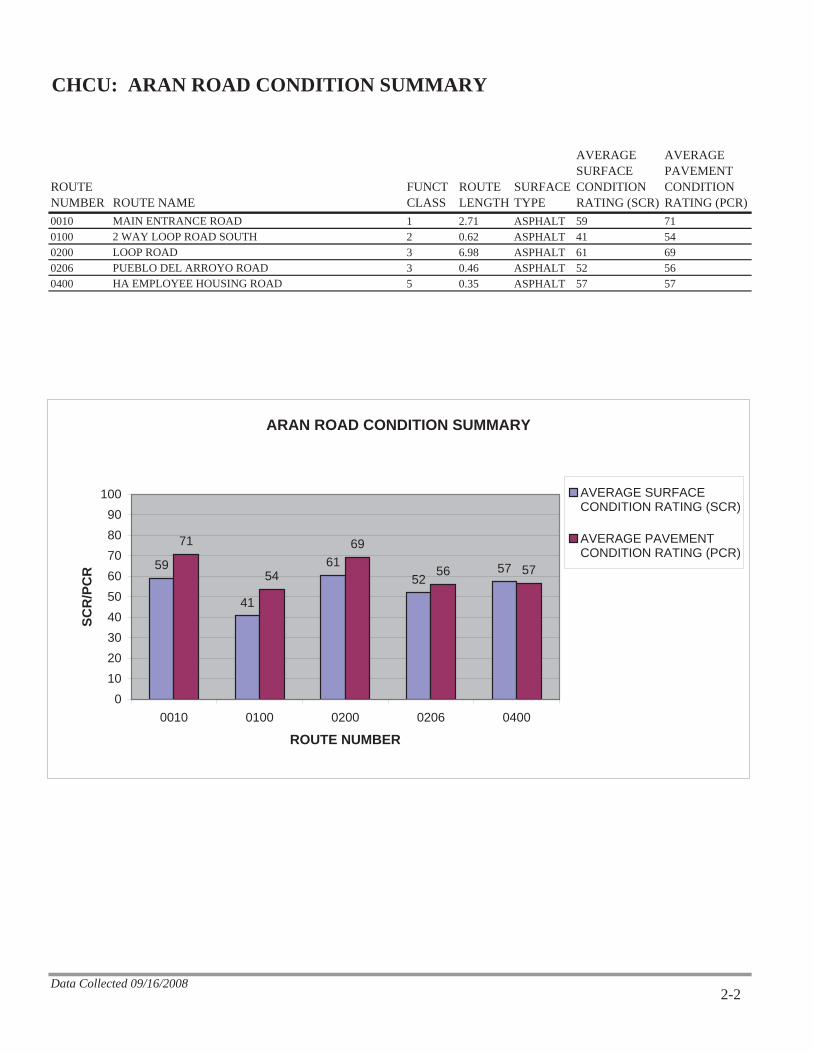
CHCU: ARAN ROAD CONDITION SUMMARY
ROUTENUMBER ROUTE NAME
FUNCTCLASS
ROUTELENGTH
SURFACETYPE
AVERAGESURFACECONDITIONRATING (SCR)
AVERAGEPAVEMENTCONDITIONRATING (PCR)
0010 MAIN ENTRANCE ROAD 1 2.71 ASPHALT 59 710100 2 WAY LOOP ROAD SOUTH 2 0.62 ASPHALT 41 540200 LOOP ROAD 3 6.98 ASPHALT 61 690206 PUEBLO DEL ARROYO ROAD 3 0.46 ASPHALT 52 560400 HA EMPLOYEE HOUSING ROAD 5 0.35 ASPHALT 57 57
Data Collected 09/16/2008
ARAN ROAD CONDITION SUMMARY
59
41
6152
57
71
54
69
56 57
0102030405060708090
100
0010 0100 0200 0206 0400
ROUTE NUMBER
SCR
/PC
R
AVERAGE SURFACECONDITION RATING (SCR)
AVERAGE PAVEMENTCONDITION RATING (PCR)
2-2

CHCU: PARKWIDE CONDITION SUMMARY
**AVERAGEPAVEMENTCONDITIONRATING (PCR)
*AVERAGEROUGHNESSCONDITIONINDEX (RCI)
*AVERAGESURFACECONDITIONRATING (SCR)
*AVERAGERUT INDEX
*AVERAGEALLIGATORCRACKINGINDEX
*AVERAGELONGITUDINALCRACKINGINDEX
*AVERAGETRANSVERSECRACKINGINDEX
*AVERAGEPATCHINGINDEX
68 85 60 67 100 98 95 100
** PCR Index is based on all ARAN-driven roads, parking areas, and manually rated routes.* Index values are based on ARAN-driven roads only.
Data Collected 09/16/2008
PARKWIDE CONDITION SUMMARY
68
85
6067
100 98 95100
0
10
20
30
40
50
60
70
80
90
100
**AVERAGE PAVEMENTCONDITION RATING
(PCR)
*AVERAGEROUGHNESS
CONDITION INDEX (RCI)
*AVERAGE SURFACECONDITION RATING
(SCR)
*AVERAGE RUT INDEX *AVERAGE ALLIGATORCRACKING INDEX
*AVERAGELONGITUDINAL
CRACKING INDEX
*AVERAGETRANSVERSE
CRACKING INDEX
*AVERAGE PATCHINGINDEX
RA
TIN
G
2-3

FRO
MM
ILEPOST
TOM
ILEPOST
PAV
EDM
ILES
PERCENTCHANGE
PERCENTCHANGE
PERCENTCHANGE COMMENT
RO
UTE
NU
MB
ER
PAVEMENT CONDITION RATING (PCR)
SURFACE CONDITION RATING (SCR)
ROUGHNESS CONDITION INDEX (RCI)
CHCU CYCLE 2 vs CYCLE 3 vs CYCLE 4 CONDITION COMPARISONS
CY
CLE 2
CY
CLE 3
CY
CLE 4
CY
CLE 2
CY
CLE 3
CY
CLE 4
CY
CLE 2
CY
CLE 3
CY
CLE 4
0010 0.00 2.732.73 -14% -22% -1%N/A 83 71 N/A 76 59 N/A 92 91
0100 0.00 0.630.63 -31% -45% -11%N/A 78 54 N/A 75 41 N/A 89 79
0200 0.00 7.017.01 -15% -19% -9%N/A 81 69 N/A 75 61 N/A 91 83
0400 0.00 0.350.35 -16% -20% -18%N/A 68 57 N/A 71 57 N/A 61 50
0
20
40
60
80
100
0010
0100
0200
0400
Cycle 2Cycle 3Cycle 4
PCR
0
20
40
60
80
100
0010
0100
0200
0400
Cycle 2Cycle 3Cycle 4
SCR
0
20
40
60
80
100
0010
0100
0200
0400
Cycle 2Cycle 3Cycle 4
RCI
4Cycle 4 Data Collected 9/16/2008 - 9/16/2008 Page 2 -
Chaco Culture National Historical Park
Section 3 Park Route Location / Condition
Maps
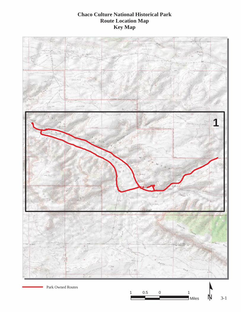
3-1ºPark Owned Routes
Chaco Culture National Historical ParkRoute Location Map
Key Map
1
1 0 10.5Miles

Rte 0906BRte 0906ARte 0206
Rte 0904Rte 0903Rte 0405Rte 0400
Rte 0902Rte 0901
Rte 0905
Rte 0907Rte 0908
Rte 0900
Rte 0200
Rte 0010
Rte 0100
3-2ºUnique colors used to differentiate routes
Chaco Culture National Historical ParkRoute Location Map
Area 1
1 0 10.5Miles
3-3º
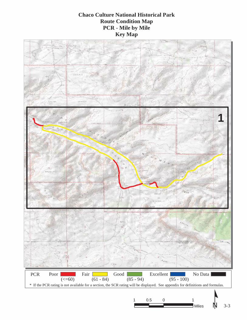
Chaco Culture National Historical ParkRoute Condition MapPCR - Mile by Mile
Key Map
1 0 10.5Miles
* If the PCR rating is not available for a section, the SCR rating will be displayed. See appendix for definitions and formulas.
PCR(<=60)
Poor(61 - 84)
Fair(85 - 94)
Good(95 - 100)
Excellent No Data
1

Rte 0200
Rte 0010
Rte 0100
Rte 0206
Rte 0400
3-4º
Chaco Culture National Historical ParkRoute Condition MapPCR - Mile by Mile
Area 1
1 0 10.5Miles
* If the PCR rating is not available for a section, the SCR rating will be displayed. See appendix for definitions and formulas.
PCR(<=60)
Poor(61 - 84)
Fair(85 - 94)
Good(95 - 100)
Excellent No Data

Chaco Culture National Historical Park
Section 4 Park Route Inventory


Chaco Culture National Historical Park
Section 5 Paved Route Condition Rating Sheets
(CRS)

!
!
!2
1
0Rte 0010
º* If the PCR rating is not available for a section, the SCR rating will be displayed. See appendix for definitions and formulas.
PCR(<=60)
Poor(61 - 84)
Fair(85 - 94)
Good(95 - 100)
Excellent No Data
ROUTE: 0010 MAIN ENTRANCE ROADCHCU : CHACO CULTURE NATIONAL HISTORICAL PARK
COLLECTED: 9/16/2008INTERMOUNTAIN REGION TOTAL LENGTH: 2.71 MilesSection Number 0 1 2Section Length (mi) 1.00 1.00 0.71Traffic
AADTSADTADT Date
Cross Section InformationNumber of Lanes 2 2 2Paved Width (ft) 24 24 25Lane Width (ft) 11 12 12Shoulder Width Right (ft) NC NC NCShoulder Width Left (ft) NC NC NC
Roadway Condition InformationSCR (Surface Condition Rating) 56 60 63PCR (Pavement Condition Rating) 69 72 72
Distress Index ValuesAlligator Cracking Index 100 100 100Longitudinal Cracking Index 96 98 99Tranverse Cracking Index 95 97 98Patching Index 100 100 100Rutting Index 64 66 66Roughness Condition Index (RCI) 92 89 92NC - Not Collected 5-1
Traffic data may be found at www.efl.fhwa.dot.govClick on PROGRAMS / NPS Traffic Data(Note: Not all parks have traffic data)
RO
UT
E:0
010
MA
INE
NT
RA
NC
ER
OA
D
!
0Rte 0100
º* If the PCR rating is not available for a section, the SCR rating will be displayed. See appendix for definitions and formulas.
PCR(<=60)
Poor(61 - 84)
Fair(85 - 94)
Good(95 - 100)
Excellent No Data
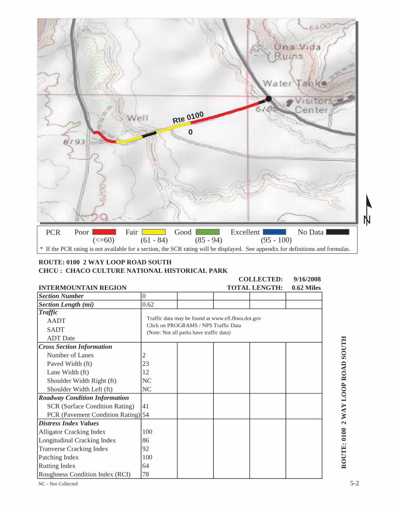
ROUTE: 0100 2 WAY LOOP ROAD SOUTHCHCU : CHACO CULTURE NATIONAL HISTORICAL PARK
COLLECTED: 9/16/2008INTERMOUNTAIN REGION TOTAL LENGTH: 0.62 MilesSection Number 0Section Length (mi) 0.62Traffic
AADTSADTADT Date
Cross Section InformationNumber of Lanes 2Paved Width (ft) 23Lane Width (ft) 12Shoulder Width Right (ft) NCShoulder Width Left (ft) NC
Roadway Condition InformationSCR (Surface Condition Rating) 41PCR (Pavement Condition Rating) 54
Distress Index ValuesAlligator Cracking Index 100Longitudinal Cracking Index 86Tranverse Cracking Index 92Patching Index 100Rutting Index 64Roughness Condition Index (RCI) 78NC - Not Collected 5-2
Traffic data may be found at www.efl.fhwa.dot.govClick on PROGRAMS / NPS Traffic Data(Note: Not all parks have traffic data)
RO
UT
E:0
100
2W
AY
LO
OP
RO
AD
SOU
TH

!
!
!
!
!
!
!
4
3
2
1
0
Rte 0200
º* If the PCR rating is not available for a section, the SCR rating will be displayed. See appendix for definitions and formulas.
PCR(<=60)
Poor(61 - 84)
Fair(85 - 94)
Good(95 - 100)
Excellent No Data
ROUTE: 0200 LOOP ROADCHCU : CHACO CULTURE NATIONAL HISTORICAL PARK
COLLECTED: 9/16/2008INTERMOUNTAIN REGION TOTAL LENGTH: 6.98 MilesSection Number 0 1 2 3 4Section Length (mi) 1.00 1.00 1.00 1.00 1.00Traffic
AADTSADTADT Date
Cross Section InformationNumber of Lanes 1 1 1 1 1Paved Width (ft) 14 14 14 14 14Lane Width (ft) 14 14 14 14 14Shoulder Width Right (ft) NC NC NC NC NCShoulder Width Left (ft) NC NC NC NC NC
Roadway Condition InformationSCR (Surface Condition Rating) 64 65 62 60 60PCR (Pavement Condition Rating) 73 74 73 66 68
Distress Index ValuesAlligator Cracking Index 100 100 100 100 100Longitudinal Cracking Index 98 97 98 97 98Tranverse Cracking Index 97 96 96 96 94Patching Index 100 100 100 100 100Rutting Index 69 73 68 68 68Roughness Condition Index (RCI) 88 88 91 76 79NC - Not Collected 5-3
Traffic data may be found at www.efl.fhwa.dot.govClick on PROGRAMS / NPS Traffic Data(Note: Not all parks have traffic data)
RO
UT
E:0
200
LO
OP
RO
AD

!
!
!
!
!
6
5
Rte 0200
º* If the PCR rating is not available for a section, the SCR rating will be displayed. See appendix for definitions and formulas.
PCR(<=60)
Poor(61 - 84)
Fair(85 - 94)
Good(95 - 100)
Excellent No Data
ROUTE: 0200 LOOP ROADCHCU : CHACO CULTURE NATIONAL HISTORICAL PARK
COLLECTED: 9/16/2008INTERMOUNTAIN REGION TOTAL LENGTH: 6.98 MilesSection Number 5 6Section Length (mi) 1.00 0.98Traffic
AADTSADTADT Date
Cross Section InformationNumber of Lanes 1 1Paved Width (ft) 14 14Lane Width (ft) 14 14Shoulder Width Right (ft) NC NCShoulder Width Left (ft) NC NC
Roadway Condition InformationSCR (Surface Condition Rating) 64 50PCR (Pavement Condition Rating) 72 60
Distress Index ValuesAlligator Cracking Index 100 100Longitudinal Cracking Index 99 98Tranverse Cracking Index 95 93Patching Index 100 100Rutting Index 70 59Roughness Condition Index (RCI) 84 75NC - Not Collected 5-4
Traffic data may be found at www.efl.fhwa.dot.govClick on PROGRAMS / NPS Traffic Data(Note: Not all parks have traffic data)
RO
UT
E:0
200
LO
OP
RO
AD
!0
Rte 0206
º* If the PCR rating is not available for a section, the SCR rating will be displayed. See appendix for definitions and formulas.
PCR(<=60)
Poor(61 - 84)
Fair(85 - 94)
Good(95 - 100)
Excellent No Data
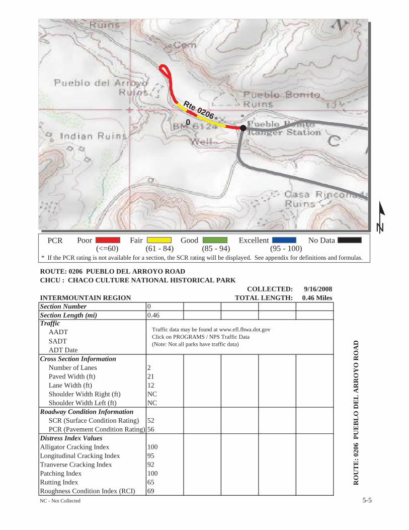
ROUTE: 0206 PUEBLO DEL ARROYO ROADCHCU : CHACO CULTURE NATIONAL HISTORICAL PARK
COLLECTED: 9/16/2008INTERMOUNTAIN REGION TOTAL LENGTH: 0.46 MilesSection Number 0Section Length (mi) 0.46Traffic
AADTSADTADT Date
Cross Section InformationNumber of Lanes 2Paved Width (ft) 21Lane Width (ft) 12Shoulder Width Right (ft) NCShoulder Width Left (ft) NC
Roadway Condition InformationSCR (Surface Condition Rating) 52PCR (Pavement Condition Rating) 56
Distress Index ValuesAlligator Cracking Index 100Longitudinal Cracking Index 95Tranverse Cracking Index 92Patching Index 100Rutting Index 65Roughness Condition Index (RCI) 69NC - Not Collected 5-5
Traffic data may be found at www.efl.fhwa.dot.govClick on PROGRAMS / NPS Traffic Data(Note: Not all parks have traffic data)
RO
UT
E:0
206
PUE
BL
OD
EL
AR
RO
YO
RO
AD
!
0Rte 0400
º* If the PCR rating is not available for a section, the SCR rating will be displayed. See appendix for definitions and formulas.
PCR(<=60)
Poor(61 - 84)
Fair(85 - 94)
Good(95 - 100)
Excellent No Data
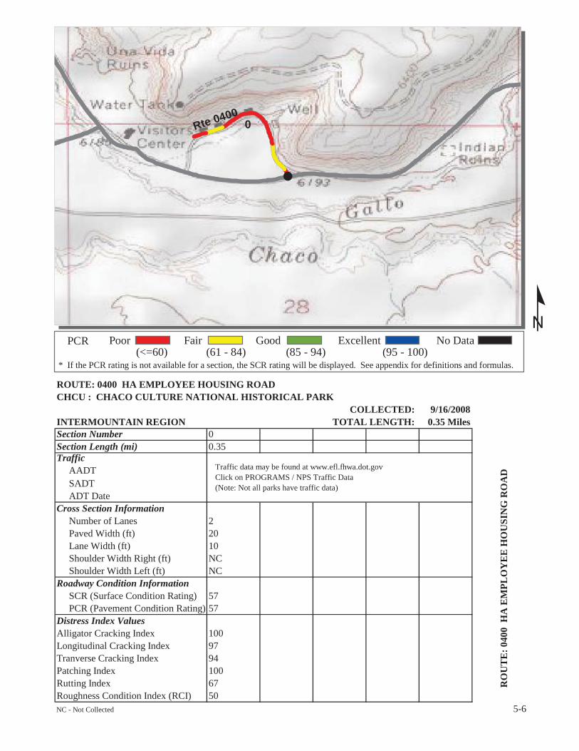
ROUTE: 0400 HA EMPLOYEE HOUSING ROADCHCU : CHACO CULTURE NATIONAL HISTORICAL PARK
COLLECTED: 9/16/2008INTERMOUNTAIN REGION TOTAL LENGTH: 0.35 MilesSection Number 0Section Length (mi) 0.35Traffic
AADTSADTADT Date
Cross Section InformationNumber of Lanes 2Paved Width (ft) 20Lane Width (ft) 10Shoulder Width Right (ft) NCShoulder Width Left (ft) NC
Roadway Condition InformationSCR (Surface Condition Rating) 57PCR (Pavement Condition Rating) 57
Distress Index ValuesAlligator Cracking Index 100Longitudinal Cracking Index 97Tranverse Cracking Index 94Patching Index 100Rutting Index 67Roughness Condition Index (RCI) 50NC - Not Collected 5-6
Traffic data may be found at www.efl.fhwa.dot.govClick on PROGRAMS / NPS Traffic Data(Note: Not all parks have traffic data)
RO
UT
E:0
400
HA
EM
PLO
YE
EH
OU
SIN
GR
OA
D
Chaco Culture National Historical Park
Section 6 Manually Rated Paved Route
Condition Rating Sheets (MRR)

CHACO CULTURE NATIONAL HISTORICAL PARKRoute 0405
UPPER MAINTENANCE AREA SERVICE ROADFROM ROUTE 0400 (HA EMPLOYEE HOUSING ROAD) AT MP 0.19 (ON RIGHT)
TO ROUTE 0915 (UPPER MAINTENANCE AREA PARKING)
RouteNumber
Public /NonPublic Lane Miles *
0405 PUBLIC 0.08
Culverts Drop Inlets GatesFire
Hydrants Curb
0 0 1 0 NO CURB* Lane miles are based on 11' lane widths
6-1
PCR
FAIR/73
Surface TypeAS
Curb & GutterNO CURB AND
GUTTER
Date Visited9/16/2008
Area (sq ft)4,541
º
Rte 0400
Rte 0904
Rte 0903
Rte 0405
200 0 200100Feet
Chaco Culture National Historical Park
Section 7 Parking Area Condition Rating Sheets

CHACO CULTURE NATIONAL HISTORICAL PARKRoute 0900
WIJIJI TRAIL PARKINGADJACENT TO ROUTE 0010 (MAIN ENTRANCE ROAD) AT MP 1.37 (ON LEFT)
TO PARKING
RouteNumber
Public /NonPublic Lane Miles *
0900 PUBLIC 0.07
Culverts Drop Inlets GatesFire
Hydrants Curb
0 0 0 0 NO CURB* Lane miles are based on 11' lane widths
7-1
Curb & GutterNO CURB AND
GUTTER
Date Visited3/17/2008
Area (sq ft)4,097
Surface TypeAS
PCR
FAIR/73
º170 0 17085Feet
Rte 0900
Rte00
10
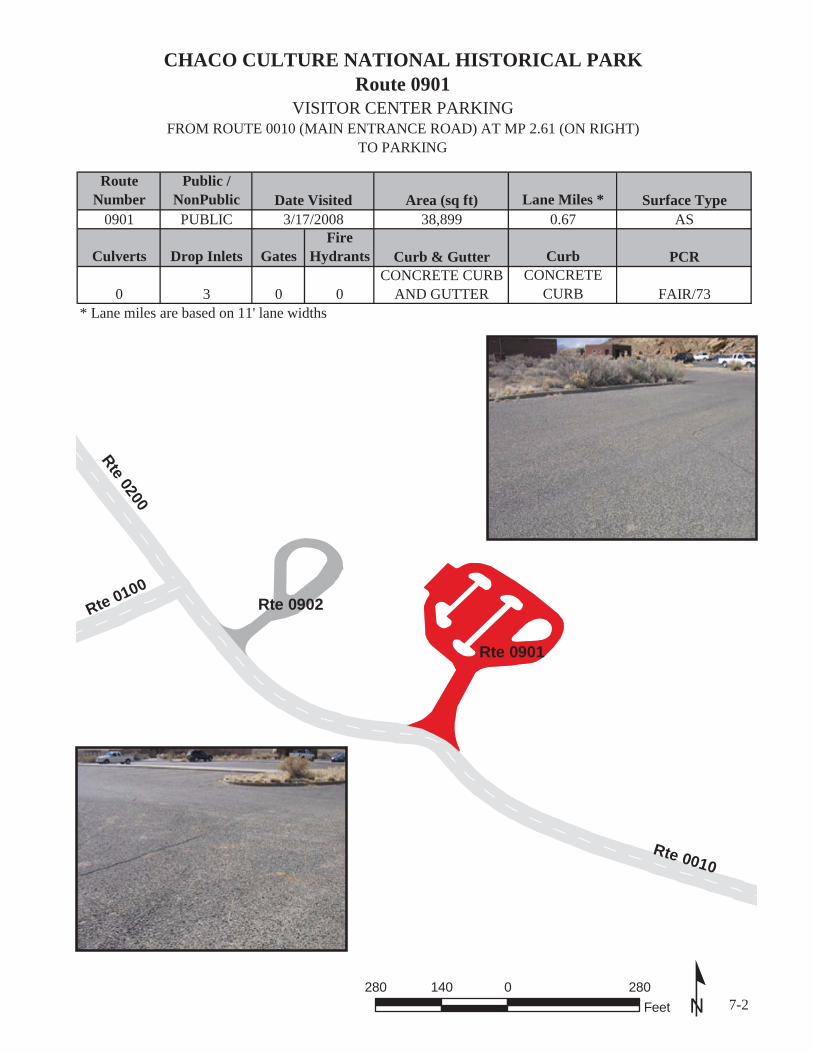
CHACO CULTURE NATIONAL HISTORICAL PARKRoute 0901
VISITOR CENTER PARKINGFROM ROUTE 0010 (MAIN ENTRANCE ROAD) AT MP 2.61 (ON RIGHT)
TO PARKING
RouteNumber
Public /NonPublic Lane Miles *
0901 PUBLIC 0.67
Culverts Drop Inlets GatesFire
Hydrants Curb
0 3 0 0CONCRETE
CURB* Lane miles are based on 11' lane widths
7-2
Surface TypeAS
PCR
FAIR/73
Curb & GutterCONCRETE CURB
AND GUTTER
Date Visited3/17/2008
Area (sq ft)38,899
º280 0 280140Feet
Rte 0901
Rte 0902
Rte 0010
Rte 0200
Rte 0100

CHACO CULTURE NATIONAL HISTORICAL PARKRoute 0902
EMPLOYEE PARKINGFROM ROUTE 0010 (MAIN ENTRANCE ROAD) AT MP 2.67 (ON RIGHT)
TO PARKING
RouteNumber
Public /NonPublic Lane Miles *
0902 PUBLIC 0.22
Culverts Drop Inlets GatesFire
Hydrants Curb
0 0 0 0CONCRETE
CURB* Lane miles are based on 11' lane widths
7-3
Surface TypeAS
PCR
FAIR/73
Curb & GutterCONCRETE CURB
AND GUTTER
Date Visited3/17/2008
Area (sq ft)12,533
º190 0 19095Feet
Rte 0010
Rte 0100
Rte 0200
Rte 0902
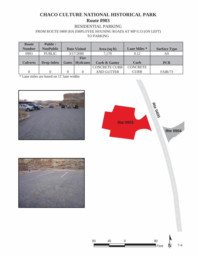
CHACO CULTURE NATIONAL HISTORICAL PARKRoute 0903
RESIDENTIAL PARKINGFROM ROUTE 0400 (HA EMPLOYEE HOUSING ROAD) AT MP 0.13 (ON LEFT)
TO PARKING
RouteNumber
Public /NonPublic Lane Miles *
0903 PUBLIC 0.12
Culverts Drop Inlets GatesFire
Hydrants Curb
0 0 0 0CONCRETE
CURB* Lane miles are based on 11' lane widths
7-4
Surface TypeAS
PCR
FAIR/73
Curb & GutterCONCRETE CURB
AND GUTTER
Date Visited3/17/2008
Area (sq ft)7,178
º90 0 9045Feet
Rte 0904
Rte0400
Rte 0903
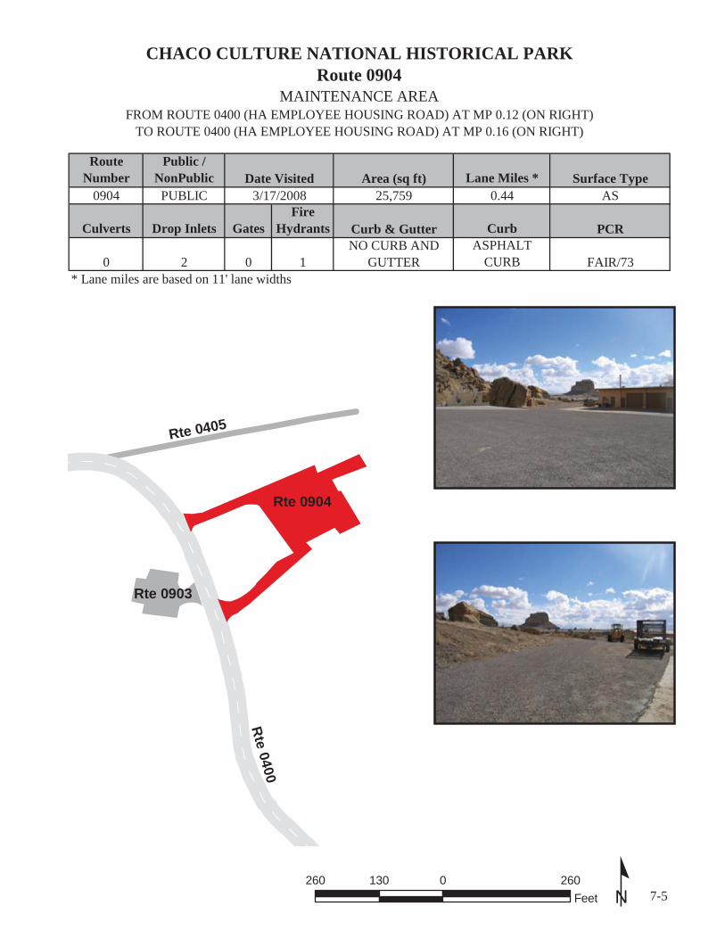
CHACO CULTURE NATIONAL HISTORICAL PARKRoute 0904
MAINTENANCE AREAFROM ROUTE 0400 (HA EMPLOYEE HOUSING ROAD) AT MP 0.12 (ON RIGHT)
TO ROUTE 0400 (HA EMPLOYEE HOUSING ROAD) AT MP 0.16 (ON RIGHT)
RouteNumber
Public /NonPublic Lane Miles *
0904 PUBLIC 0.44
Culverts Drop Inlets GatesFire
Hydrants Curb
0 2 0 1ASPHALT
CURB* Lane miles are based on 11' lane widths
7-5
Surface TypeAS
PCR
FAIR/73
Curb & GutterNO CURB AND
GUTTER
Date Visited3/17/2008
Area (sq ft)25,759
º260 0 260130Feet
Rte 0903
Rte 0904
Rte
0400Rte 0405
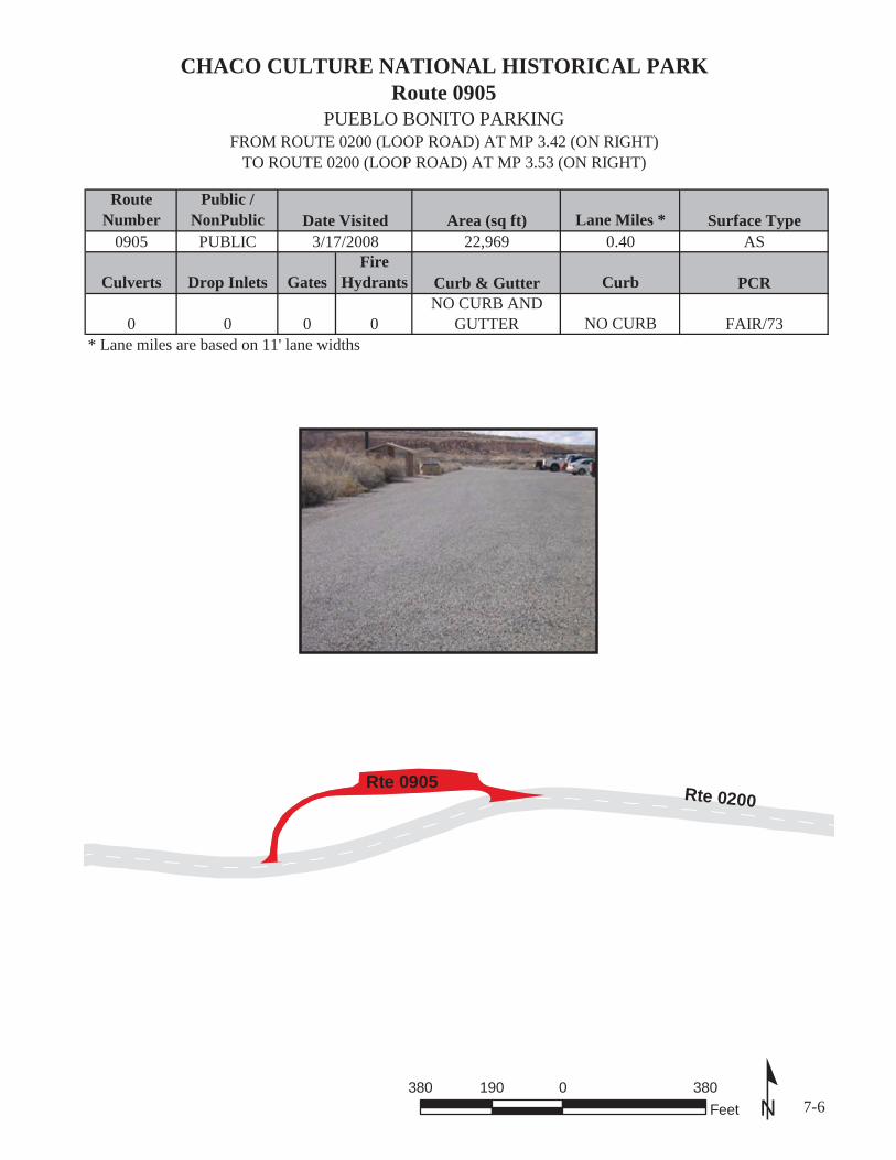
CHACO CULTURE NATIONAL HISTORICAL PARKRoute 0905
PUEBLO BONITO PARKINGFROM ROUTE 0200 (LOOP ROAD) AT MP 3.42 (ON RIGHT)
TO ROUTE 0200 (LOOP ROAD) AT MP 3.53 (ON RIGHT)
RouteNumber
Public /NonPublic Lane Miles *
0905 PUBLIC 0.40
Culverts Drop Inlets GatesFire
Hydrants Curb
0 0 0 0 NO CURB* Lane miles are based on 11' lane widths
7-6
Surface TypeAS
PCR
FAIR/73
Curb & GutterNO CURB AND
GUTTER
Date Visited3/17/2008
Area (sq ft)22,969
º380 0 380190Feet
Rte 0200Rte 0905

CHACO CULTURE NATIONAL HISTORICAL PARKRoute 0906A
PUEBLO DEL ARROYO PARKING NORTHADJACENT TO ROUTE 0206 (PUEBLO DEL ARROYO ROAD) AT MP 0.43 (ON LEFT)
TO PARKING
RouteNumber
Public /NonPublic Lane Miles *
0906A PUBLIC 0.06
Culverts Drop Inlets GatesFire
Hydrants Curb
0 0 0 0 NO CURB* Lane miles are based on 11' lane widths
7-7
Surface TypeAS
PCR
FAIR/73
Curb & GutterNO CURB AND
GUTTER
Date Visited3/17/2008
Area (sq ft)3,448
º120 0 12060Feet
Rte 0906B
Rte 0906A
Rte
0206

CHACO CULTURE NATIONAL HISTORICAL PARKRoute 0906B
PUEBLO DEL ARROYO PARKING SOUTHADJACENT TO ROUTE 0206 (PUEBLO DEL ARROYO ROAD) AT MP 0.43 (ON RIGHT)
TO PARKING
RouteNumber
Public /NonPublic Lane Miles *
0906B PUBLIC 0.08
Culverts Drop Inlets GatesFire
Hydrants Curb
0 0 0 0 NO CURB* Lane miles are based on 11' lane widths
7-8
Surface TypeAS
PCR
FAIR/73
Curb & GutterNO CURB AND
GUTTER
Date Visited3/17/2008
Area (sq ft)4,579
º120 0 12060Feet
Rte 0906B
Rte 0906A
Rte
0206
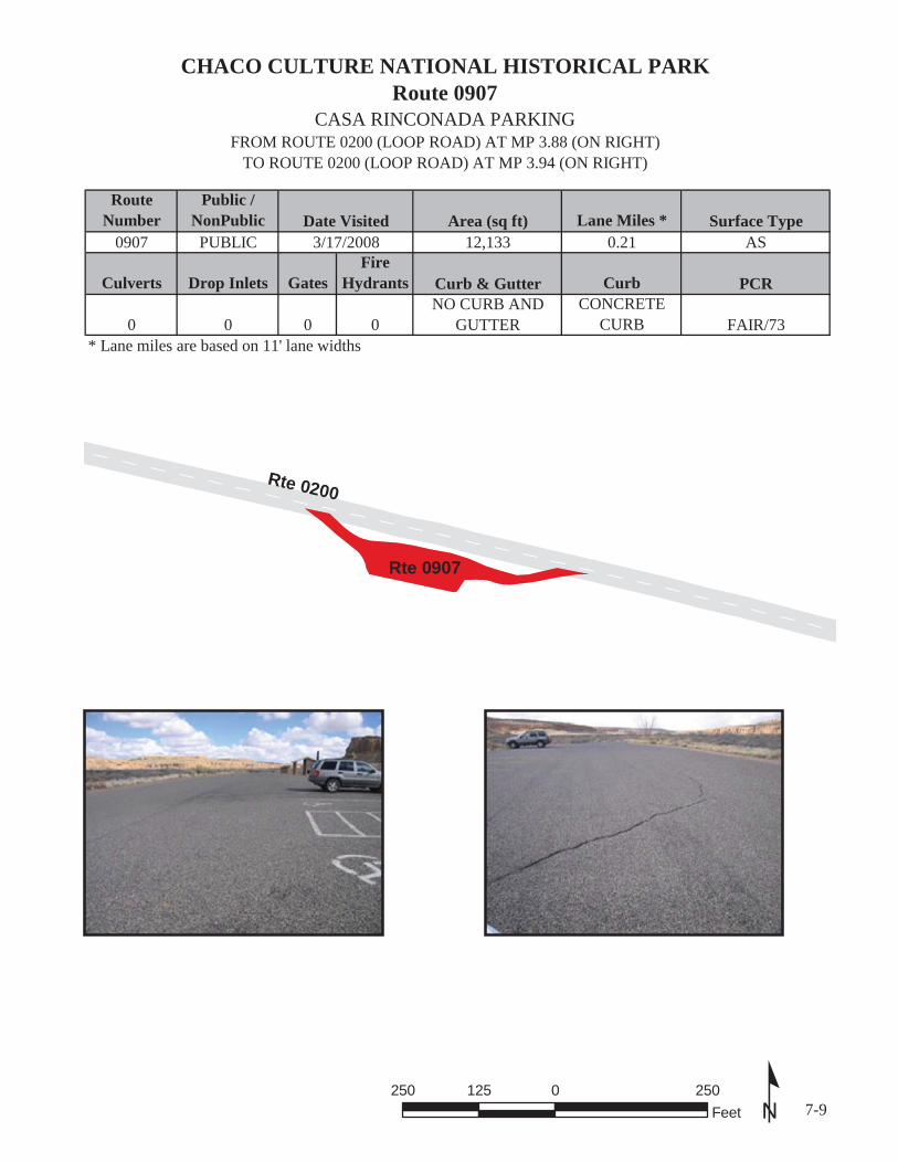
CHACO CULTURE NATIONAL HISTORICAL PARKRoute 0907
CASA RINCONADA PARKINGFROM ROUTE 0200 (LOOP ROAD) AT MP 3.88 (ON RIGHT)
TO ROUTE 0200 (LOOP ROAD) AT MP 3.94 (ON RIGHT)
RouteNumber
Public /NonPublic Lane Miles *
0907 PUBLIC 0.21
Culverts Drop Inlets GatesFire
Hydrants Curb
0 0 0 0CONCRETE
CURB* Lane miles are based on 11' lane widths
7-9
Surface TypeAS
PCR
FAIR/73
Curb & GutterNO CURB AND
GUTTER
Date Visited3/17/2008
Area (sq ft)12,133
º250 0 250125Feet
Rte 0200
Rte 0907

CHACO CULTURE NATIONAL HISTORICAL PARKRoute 0908
PREHISTORIC STAIRWAY PARKINGFROM ROUTE 0200 (LOOP ROAD) AT MP 4.11 (ON RIGHT)
TO ROUTE 0200 (LOOP ROAD) AT MP 4.16 (ON RIGHT)
RouteNumber
Public /NonPublic Lane Miles *
0908 PUBLIC 0.09
Culverts Drop Inlets GatesFire
Hydrants Curb
0 0 0 0 NO CURB* Lane miles are based on 11' lane widths
7-10
Surface TypeAS
PCR
FAIR/73
Curb & GutterNO CURB AND
GUTTER
Date Visited3/17/2008
Area (sq ft)4,998
º160 0 16080Feet
Rte 0200
Rte 0908

Chaco Culture National Historical Park
Section 8 Parkwide / Route Maintenance
Features Summaries

CHCU: PARKWIDE MAINTENANCE FEATURES SUMMARY
FEATURE LINEAR FEET COUNTBARRIER 1,959 --BOLLARD 0 --BRIDGE -- 4CABLE 0 --CATTLE GUARD -- 0CULVERT -- 52CURB 2,323 --DROP INLET -- 5FIRE HYDRANT -- 5GATE -- 3GUARD/GUIDE RAIL 1,959 --GUARD/GUIDE WALL 0 --INTERSECTION -- 49LOW WATER CROSSING 0 0MILE MARKER -- 0OVERPASS -- 0OVERHEAD SIGN -- 0PARK BOUNDARY -- 1PAVED DITCH 0 --PULLOUT -- 0RAILROAD CROSSING -- 0RETAINING WALL -- 0SIGN -- 75STATE BOUNDARY -- 0TEMPORARY BARRIER 0 --TRAFFIC LIGHT -- 0TUNNEL -- 0TURNOUT 0 --
Data Collected 9/16/2008
Notice: Culverts and drop inlets were marked by NPS and inventoried by RIP in Cycle 4, therefore the culvert and drop inlet count below includes those on ARAN-driven routes, Manually Rated Routes and in Paved Parking Areas.
8-1

CHCU: ROUTE MAINTENANCE FEATURES SUMMARY
FEATURE RO
UT
E 0
010
MA
IN E
NT
RA
NC
E R
OA
D
RO
UT
E 0
100
2 W
AY
LO
OP
RO
AD
SO
UT
H
RO
UT
E 0
200
LO
OP
RO
AD
RO
UT
E 0
206
PUE
BL
O D
EL
AR
RO
YO
RO
AD
RO
UT
E 0
400
HA
EM
PLO
YE
E H
OU
SIN
G R
OA
D
UNIT
BARRIER LINEAR FEETBOLLARD LINEAR FEETBRIDGE EACHCABLE LINEAR FEETCATTLE GUARD EACHCULVERT EACHCURB LINEAR FEETDROP INLET EACHFIRE HYDRANT EACHGATE EACHGUARD/GUIDE RAIL LINEAR FEETGUARD/GUIDE WALL LINEAR FEETINTERSECTION EACHLOW WATER CROSSING EACHLOW WATER CROSSING LINEAR FEETMILE MARKER EACHOVERHEAD SIGN EACHOVERPASS EACHPARK BOUNDARY EACHPAVED DITCH LINEAR FEETPULLOUT EACHRAILROAD CROSSING EACHRETAINING WALL EACHSIGN EACHSTATE BOUNDARY EACHTEMPORARY BARRIER LINEAR FEETTRAFFIC LIGHT EACHTUNNEL EACHTURNOUT LINEAR FEET
Data Collected 9/16/2008
11
3010
9560
0
03010
1
100
1,46318
00
0
1
0
0
Notice: Culverts and drop inlets were marked by NPS and inventoried by RIP in Cycle 4, therefore the culvert and drop inlet count above includes those on ARAN-driven routes, Manually Rated Routes and in Paved Parking Areas.
00
19000 0
00
0000 0 0
20
00
0
5760
1
9560700000
700
0000
0
2430
507010
30
025070150000000
000
00030
0
1950000
4200
0
019509
0
00140
00
00
00
0
0000
0
03
2
00700000
00
0000
000
00000
0
5
1
8-2

CHCU: STRUCTURE LISTROUTENUMBER
FUNCTIONALCLASS
MILEPOSTSTART
MILEPOSTEND FEATURE
STRUCTURENUMBER
0010 1 1.53 1.54 BRIDGE 7400-0040100 2 0.403 0.445 BRIDGE 7400-0020200 3 3.667 3.703 BRIDGE 7400-001
Data Collected 9/16/2008 8-3

Chaco Culture National Historical Park
Section 9 Park Route Maintenance Features
Road Logs

FROM MILEPOST
TO MILEPOST FEATURE SIDE COMMENT
ROUTE 0010: MAIN ENTRANCE ROAD
CHCU: ROUTE MAINTENANCE FEATURES ROAD LOG
0.000 ROUTE BEGIN N/A FROM PARK BOUNDARY AND INDIAN SERVICE ROUTE 79500.000
0.000 PARK BOUNDARY N/A NORTH PARK BOUNDARY0.000
0.000 INTERSECTION N/A UNPAVED ROUTE (INDIAN SERVICE ROUTE 7950 / NON NPS)0.000
0.023 SIGN RIGHT GUIDE, CHACO CULTURE NATIONAL HISTORICAL PARK WORLD HERITAGE SITE
0.023
0.059 SIGN RIGHT GUIDE, PAY ENTRANCE FEE AT VISITOR CENTER (2.5 MI) $8.00 PER VEHICLE
0.059
0.093 SIGN RIGHT GUIDE, HIKING RESTRICTED TO ESTABLISHED TRAILS ALL RUINS, TRAILS AND LOOP ROAD CLOSED AT SUNSET BACKCOUNTRY
0.093
0.154 SIGN RIGHT REGULATORY, SPEED LIMIT 350.154
0.210 CULVERT N/A0.210
0.369 INTERSECTION RIGHT ROUTE 0402 (WATER TANK ROAD) 0.369
0.390 CULVERT N/A0.390
0.466 CULVERT N/A0.466
0.724 CULVERT N/A0.724
0.862 CULVERT N/A0.862
0.942 CULVERT N/A0.942
1.142 CULVERT N/A1.142
1.170 CULVERT N/A1.170
1.302 CULVERT N/A1.302
1.368 INTERSECTION LEFT ROUTE 0900 (WIJIJI TRAIL PARKING) 1.368
1.393 SIGN LEFT GUIDE, UNABLE TO READ FROM VIDEO1.393
1.393 SIGN RIGHT GUIDE, WIJIJI TRAILHEAD1.393
1.444 CULVERT N/A1.444
1.452 INTERSECTION LEFT UNPAVED ROUTE (WIJIJI TRAIL) 1.452
1.453 SIGN RIGHT GUIDE, NO BICYCLES1.453
1.453 SIGN RIGHT GUIDE, UNABLE TO READ FROM VIDEO1.453
1.527 CURB RIGHT 1.462
1.464 CULVERT N/A1.464
1.550 GUARD/GUIDE RAIL RIGHT 1.522
1.551 GUARD/GUIDE RAIL LEFT 1.522
1.540 BRIDGE N/A 7400-004 (GALLO WASH BRIDGE)1.530
1.566 CURB RIGHT 1.542
1.736 CURB LEFT 1.548
1.587 SIGN RIGHT GUIDE, VISITOR CENTER CAMPGROUND1.587
9-1Data Collected 9/16/2008

FROM MILEPOST
TO MILEPOST FEATURE SIDE COMMENT
ROUTE 0010: MAIN ENTRANCE ROAD
CHCU: ROUTE MAINTENANCE FEATURES ROAD LOG
1.606 CULVERT N/A1.606
1.624 INTERSECTION RIGHT ROUTE 0202 (GALLO CAMPGROUND LOOP ROAD) 1.624
1.642 CULVERT N/A1.642
1.651 SIGN RIGHT GUIDE, CAMPGROUND WIJIJI TRAILHEAD PARK EXIT1.651
2.005 CULVERT N/A2.005
2.119 SIGN RIGHT WARNING, GRAPHIC SIGN, NO TEXT2.119
2.137 SIGN RIGHT REGULATORY, SPEED LIMIT 352.137
2.215 SIGN LEFT GUIDE, FAJADA BUTTE VIEW2.215
2.216 SIGN RIGHT GUIDE, GRAPHIC SIGN, NO TEXT2.216
2.218 CULVERT N/A2.218
2.229 INTERSECTION RIGHT ROUTE 0400 (HA EMPLOYEE HOUSING ROAD) 2.229
2.235 INTERSECTION LEFT ROUTE 0910 (FAJADA VIEW PARKING) 2.235
2.256 CULVERT N/A2.256
2.256 SIGN RIGHT GUIDE, FAJADA BUTTE VIEW2.256
2.256 SIGN RIGHT GUIDE, VISITOR CENTER2.256
2.347 SIGN RIGHT WARNING, GRAPHIC SIGN, NO TEXT2.347
2.550 CULVERT N/A2.550
2.574 SIGN RIGHT GUIDE, VISITOR CENTER PAY ENTRANCE FEE HERE2.574
2.602 INTERSECTION RIGHT ROUTE 0901 (VISITOR CENTER PARKING) 2.602
2.607 SIGN RIGHT REGULATORY, YIELD2.607
2.629 FIRE HYDRANT RIGHT 2.629
2.674 INTERSECTION RIGHT ROUTE 0902 (EMPLOYEE PARKING) 2.674
2.700 CULVERT N/A2.700
2.701 INTERSECTION LEFT ROUTE 0100 (2 WAY LOOP ROAD SOUTH) 2.701
2.710 INTERSECTION N/A ROUTE 0200 (LOOP ROAD) 2.710
2.710 ROUTE END N/A TO INTERSECTION OF ROUTE 0100 AND ROUTE 02002.710
9-2Data Collected 9/16/2008
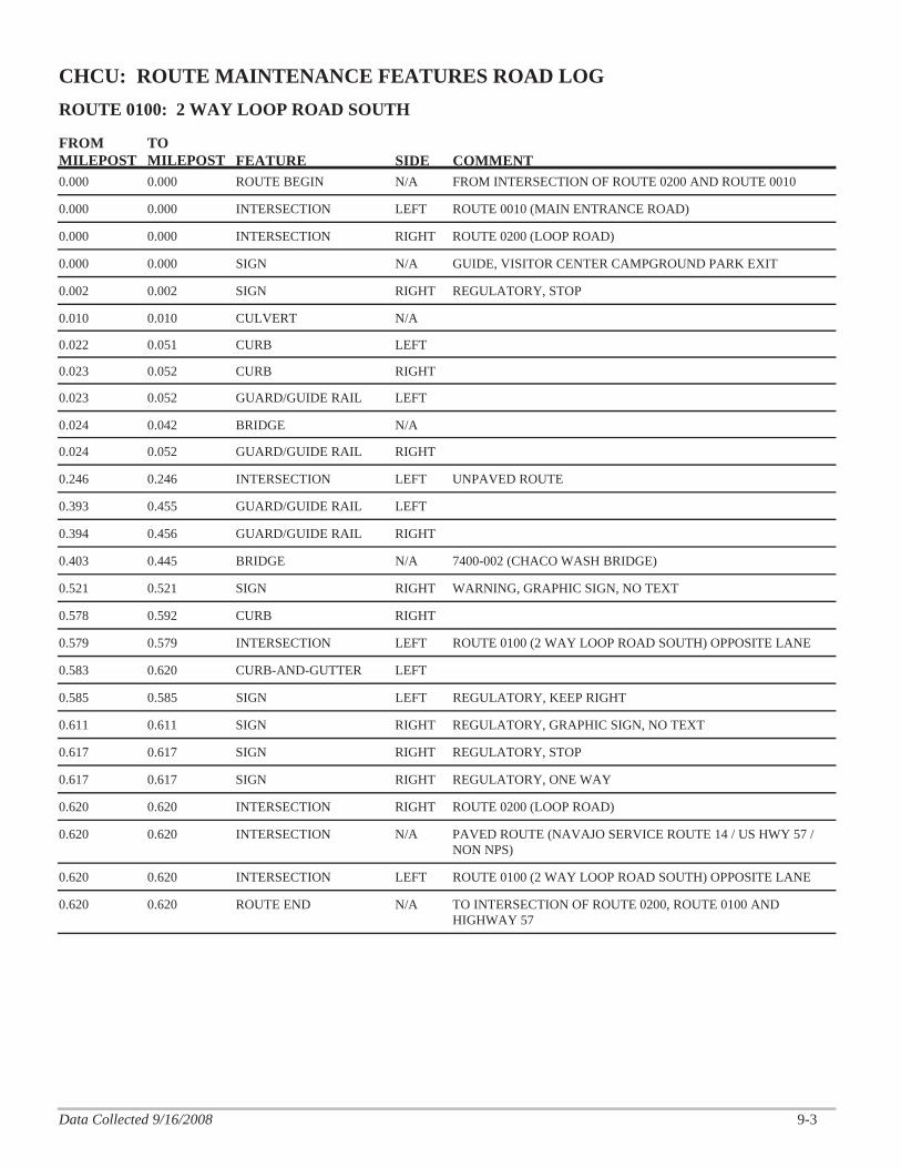
FROM MILEPOST
TO MILEPOST FEATURE SIDE COMMENT
ROUTE 0100: 2 WAY LOOP ROAD SOUTH
CHCU: ROUTE MAINTENANCE FEATURES ROAD LOG
0.000 ROUTE BEGIN N/A FROM INTERSECTION OF ROUTE 0200 AND ROUTE 00100.000
0.000 INTERSECTION LEFT ROUTE 0010 (MAIN ENTRANCE ROAD)0.000
0.000 INTERSECTION RIGHT ROUTE 0200 (LOOP ROAD)0.000
0.000 SIGN N/A GUIDE, VISITOR CENTER CAMPGROUND PARK EXIT0.000
0.002 SIGN RIGHT REGULATORY, STOP0.002
0.010 CULVERT N/A0.010
0.051 CURB LEFT0.022
0.052 CURB RIGHT0.023
0.052 GUARD/GUIDE RAIL LEFT 0.023
0.042 BRIDGE N/A0.024
0.052 GUARD/GUIDE RAIL RIGHT 0.024
0.246 INTERSECTION LEFT UNPAVED ROUTE 0.246
0.455 GUARD/GUIDE RAIL LEFT 0.393
0.456 GUARD/GUIDE RAIL RIGHT 0.394
0.445 BRIDGE N/A 7400-002 (CHACO WASH BRIDGE)0.403
0.521 SIGN RIGHT WARNING, GRAPHIC SIGN, NO TEXT0.521
0.592 CURB RIGHT 0.578
0.579 INTERSECTION LEFT ROUTE 0100 (2 WAY LOOP ROAD SOUTH) OPPOSITE LANE 0.579
0.620 CURB-AND-GUTTER LEFT 0.583
0.585 SIGN LEFT REGULATORY, KEEP RIGHT0.585
0.611 SIGN RIGHT REGULATORY, GRAPHIC SIGN, NO TEXT0.611
0.617 SIGN RIGHT REGULATORY, STOP0.617
0.617 SIGN RIGHT REGULATORY, ONE WAY0.617
0.620 INTERSECTION RIGHT ROUTE 0200 (LOOP ROAD) 0.620
0.620 INTERSECTION N/A PAVED ROUTE (NAVAJO SERVICE ROUTE 14 / US HWY 57 / NON NPS)
0.620
0.620 INTERSECTION LEFT ROUTE 0100 (2 WAY LOOP ROAD SOUTH) OPPOSITE LANE 0.620
0.620 ROUTE END N/A TO INTERSECTION OF ROUTE 0200, ROUTE 0100 AND HIGHWAY 57
0.620
9-3Data Collected 9/16/2008
FROM MILEPOST
TO MILEPOST FEATURE SIDE COMMENT
ROUTE 0200: LOOP ROAD
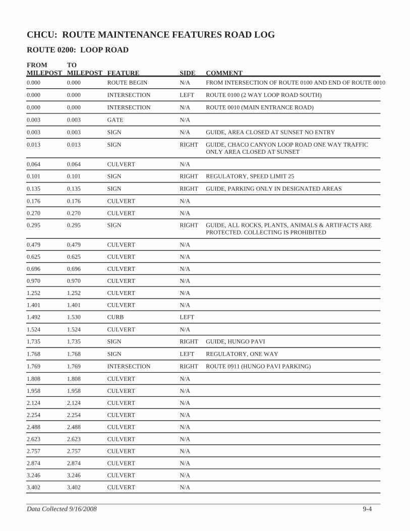
CHCU: ROUTE MAINTENANCE FEATURES ROAD LOG
0.000 ROUTE BEGIN N/A FROM INTERSECTION OF ROUTE 0100 AND END OF ROUTE 00100.000
0.000 INTERSECTION LEFT ROUTE 0100 (2 WAY LOOP ROAD SOUTH)0.000
0.000 INTERSECTION N/A ROUTE 0010 (MAIN ENTRANCE ROAD)0.000
0.003 GATE N/A 0.003
0.003 SIGN N/A GUIDE, AREA CLOSED AT SUNSET NO ENTRY0.003
0.013 SIGN RIGHT GUIDE, CHACO CANYON LOOP ROAD ONE WAY TRAFFIC ONLY AREA CLOSED AT SUNSET
0.013
0.064 CULVERT N/A0.064
0.101 SIGN RIGHT REGULATORY, SPEED LIMIT 250.101
0.135 SIGN RIGHT GUIDE, PARKING ONLY IN DESIGNATED AREAS0.135
0.176 CULVERT N/A0.176
0.270 CULVERT N/A0.270
0.295 SIGN RIGHT GUIDE, ALL ROCKS, PLANTS, ANIMALS & ARTIFACTS ARE PROTECTED. COLLECTING IS PROHIBITED
0.295
0.479 CULVERT N/A0.479
0.625 CULVERT N/A0.625
0.696 CULVERT N/A0.696
0.970 CULVERT N/A0.970
1.252 CULVERT N/A1.252
1.401 CULVERT N/A1.401
1.530 CURB LEFT 1.492
1.524 CULVERT N/A1.524
1.735 SIGN RIGHT GUIDE, HUNGO PAVI1.735
1.768 SIGN LEFT REGULATORY, ONE WAY1.768
1.769 INTERSECTION RIGHT ROUTE 0911 (HUNGO PAVI PARKING) 1.769
1.808 CULVERT N/A1.808
1.958 CULVERT N/A1.958
2.124 CULVERT N/A2.124
2.254 CULVERT N/A2.254
2.488 CULVERT N/A2.488
2.623 CULVERT N/A2.623
2.757 CULVERT N/A2.757
2.874 CULVERT N/A2.874
3.246 CULVERT N/A3.246
3.402 CULVERT N/A3.402
9-4Data Collected 9/16/2008

FROM MILEPOST
TO MILEPOST FEATURE SIDE COMMENT
ROUTE 0200: LOOP ROAD
CHCU: ROUTE MAINTENANCE FEATURES ROAD LOG
3.410 SIGN RIGHT GUIDE, PUEBLO BONITO CHETRO KETL3.410
3.424 INTERSECTION RIGHT ROUTE 0905 (PUEBLO BONITO PARKING) 3.424
3.428 SIGN LEFT REGULATORY, ONE WAY3.428
3.530 INTERSECTION RIGHT ROUTE 0905 (PUEBLO BONITO PARKING) 3.530
3.534 SIGN LEFT REGULATORY, ONE WAY3.534
3.583 SIGN RIGHT GUIDE, PUEBLO DEL ARROYO PUEBLO ALTO TRAILHEAD PENASEO BLANCO TRAILHEAD
3.583
3.583 SIGN RIGHT GUIDE, VISITOR CENTER CASA RINCONADA CAMPGROUND PARK EXIT
3.583
3.602 CULVERT N/A3.602
3.614 INTERSECTION RIGHT ROUTE 0206 (PUEBLO DEL ARROYO ROAD) 3.614
3.616 SIGN RIGHT WARNING, GRAPHIC SIGN, NO TEXT3.616
3.627 CURB-AND-GUTTER RIGHT 3.619
3.632 INTERSECTION RIGHT ROUTE 0206 (PUEBLO DEL ARROYO ROAD) SPUR 3.632
3.655 SIGN RIGHT GUIDE, ONE WAY ROAD NEXT 4 MILES3.655
3.704 GUARD/GUIDE RAIL LEFT 3.656
3.704 GUARD/GUIDE RAIL RIGHT 3.656
3.703 BRIDGE N/A 7400-001 (PUEBLO BONITO BRIDGE)3.667
3.738 INTERSECTION RIGHT ROUTE 0203 (SOUTH ENTRANCE ROAD) 3.738
3.771 SIGN RIGHT REGULATORY, SPEED LIMIT 253.771
3.848 SIGN RIGHT GUIDE, CASA RINCONADA VISITOR CENTER3.848
3.875 INTERSECTION RIGHT ROUTE 0907 (CASA RINCONADA PARKING) 3.875
3.879 SIGN LEFT REGULATORY, ONE WAY3.879
3.939 SIGN LEFT REGULATORY, ONE WAY3.939
3.941 INTERSECTION RIGHT ROUTE 0907 (CASA RINCONADA PARKING) 3.941
3.950 CULVERT N/A3.950
3.978 SIGN RIGHT REGULATORY, SPEED LIMIT 353.978
4.076 SIGN RIGHT GUIDE, STAIRWAY4.076
4.105 INTERSECTION RIGHT ROUTE 0908 (PREHISTORIC STAIRWAY PARKING) 4.105
4.156 INTERSECTION RIGHT ROUTE 0908 (PREHISTORIC STAIRWAY PARKING) 4.156
4.189 CULVERT N/A4.189
4.472 SIGN RIGHT REGULATORY, SPEED LIMIT 354.472
4.977 CULVERT N/A4.977
5.225 CULVERT N/A5.225
9-5Data Collected 9/16/2008
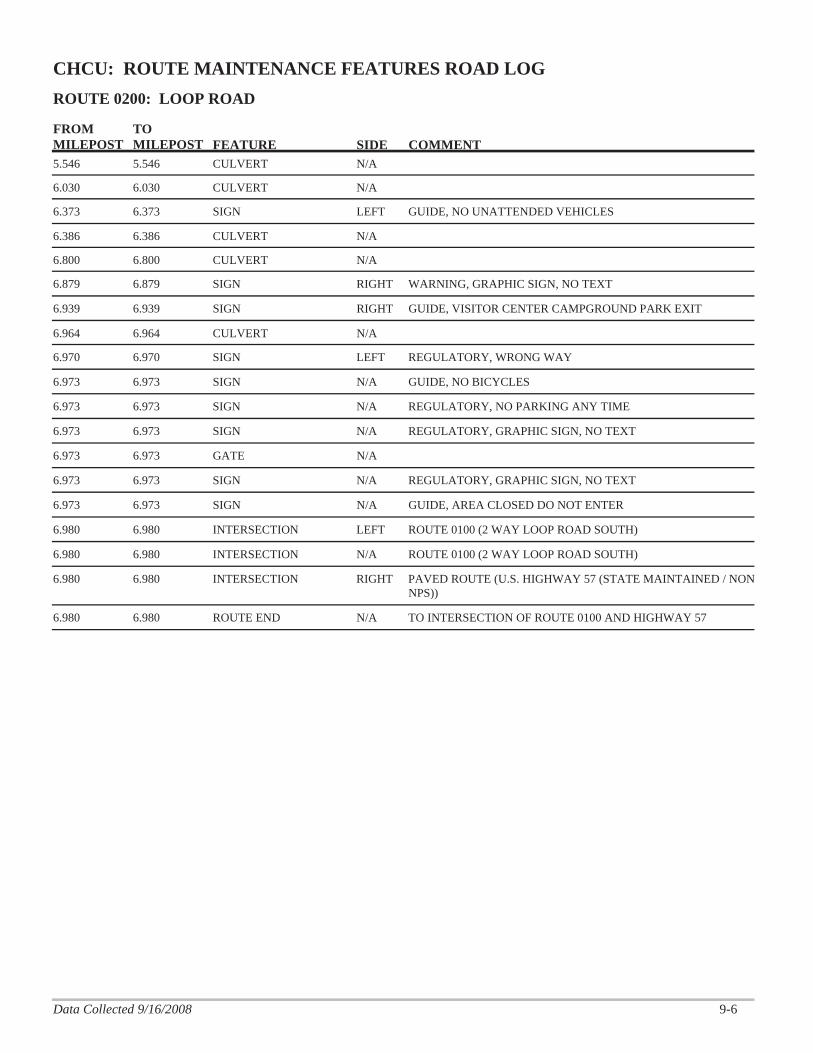
FROM MILEPOST
TO MILEPOST FEATURE SIDE COMMENT
ROUTE 0200: LOOP ROAD
CHCU: ROUTE MAINTENANCE FEATURES ROAD LOG
5.546 CULVERT N/A5.546
6.030 CULVERT N/A6.030
6.373 SIGN LEFT GUIDE, NO UNATTENDED VEHICLES6.373
6.386 CULVERT N/A6.386
6.800 CULVERT N/A6.800
6.879 SIGN RIGHT WARNING, GRAPHIC SIGN, NO TEXT6.879
6.939 SIGN RIGHT GUIDE, VISITOR CENTER CAMPGROUND PARK EXIT6.939
6.964 CULVERT N/A6.964
6.970 SIGN LEFT REGULATORY, WRONG WAY6.970
6.973 SIGN N/A GUIDE, NO BICYCLES6.973
6.973 SIGN N/A REGULATORY, NO PARKING ANY TIME6.973
6.973 SIGN N/A REGULATORY, GRAPHIC SIGN, NO TEXT6.973
6.973 GATE N/A 6.973
6.973 SIGN N/A REGULATORY, GRAPHIC SIGN, NO TEXT6.973
6.973 SIGN N/A GUIDE, AREA CLOSED DO NOT ENTER6.973
6.980 INTERSECTION LEFT ROUTE 0100 (2 WAY LOOP ROAD SOUTH) 6.980
6.980 INTERSECTION N/A ROUTE 0100 (2 WAY LOOP ROAD SOUTH) 6.980
6.980 INTERSECTION RIGHT PAVED ROUTE (U.S. HIGHWAY 57 (STATE MAINTAINED / NON NPS))
6.980
6.980 ROUTE END N/A TO INTERSECTION OF ROUTE 0100 AND HIGHWAY 57 6.980
9-6Data Collected 9/16/2008

FROM MILEPOST
TO MILEPOST FEATURE SIDE COMMENT
ROUTE 0206: PUEBLO DEL ARROYO ROAD
CHCU: ROUTE MAINTENANCE FEATURES ROAD LOG
0.000 ROUTE BEGIN N/A FROM ROUTE 0200 (LOOP ROAD) AT MP 3.61 (ON RIGHT)0.000
0.000 INTERSECTION LEFT ROUTE 0200 (LOOP ROAD)0.000
0.000 INTERSECTION N/A ROUTE 0200 (LOOP ROAD)0.000
0.004 SIGN LEFT REGULATORY, ONE WAY0.004
0.012 CURB-AND-GUTTER LEFT 0.004
0.008 SIGN RIGHT REGULATORY, YIELD0.008
0.009 SIGN LEFT REGULATORY, ONLY0.009
0.014 INTERSECTION LEFT ROUTE 0206 (PUEBLO DEL ARROYO ROAD) SPUR 0.014
0.109 SIGN RIGHT REGULATORY, NO PARKING ANY TIME0.109
0.111 INTERSECTION RIGHT UNPAVED ROUTE 0.111
0.111 SIGN RIGHT REGULATORY, NO PARKING ANY TIME0.111
0.113 SIGN RIGHT GUIDE, UNABLE TO READ FROM VIDEO0.113
0.114 SIGN RIGHT REGULATORY, NO PARKING ANY TIME0.114
0.250 CULVERT N/A0.250
0.334 INTERSECTION LEFT ROUTE 0206 (PUEBLO DEL ARROYO ROAD) 0.334
0.341 SIGN RIGHT WARNING, GRAPHIC SIGN, NO TEXT0.341
0.347 SIGN LEFT REGULATORY, KEEP RIGHT0.347
0.396 GUARD/GUIDE RAIL RIGHT 0.366
0.367 SIGN RIGHT WARNING, GRAPHIC SIGN, NO TEXT0.367
0.367 SIGN RIGHT WARNING, 10 M.P.H.0.367
0.394 SIGN RIGHT WARNING, GRAPHIC SIGN, NO TEXT0.394
0.396 SIGN RIGHT GUIDE, WETHERILL CEMETERY 600 FT ROUNDTRIP STAY ON TRAIL
0.396
0.405 GUARD/GUIDE RAIL RIGHT 0.398
0.404 SIGN RIGHT REGULATORY, STOP0.404
0.405 INTERSECTION RIGHT UNPAVED ROUTE (NAVAJO SERVICE ROUTE 14 / US HWY 57) TRAIL ACCESS
0.405
0.433 INTERSECTION LEFT ROUTE 0906A (PUEBLO DEL ARROYO PARKING NORTH) 0.433
0.433 INTERSECTION RIGHT ROUTE 0906B (PUEBLO DEL ARROYO PARKING SOUTH) 0.433
0.460 INTERSECTION N/A ROUTE 0206 (PUEBLO DEL ARROYO ROAD) 0.460
0.460 ROUTE END N/A TO END OF LOOP0.460
9-7Data Collected 9/16/2008

FROM MILEPOST
TO MILEPOST FEATURE SIDE COMMENT
ROUTE 0400: HA EMPLOYEE HOUSING ROAD
CHCU: ROUTE MAINTENANCE FEATURES ROAD LOG
0.000 ROUTE BEGIN N/A FROM ROUTE 0010 (MAIN ENTRANCE ROAD) AT MP 2.23 (ON RIGHT)
0.000
0.000 INTERSECTION LEFT ROUTE 0010 (MAIN ENTRANCE ROAD)0.000
0.000 INTERSECTION RIGHT ROUTE 0010 (MAIN ENTRANCE ROAD)0.000
0.011 SIGN RIGHT REGULATORY, FASTEN YOUR SEAT BELTS0.011
0.011 SIGN RIGHT REGULATORY, STOP0.011
0.011 SIGN LEFT REGULATORY, WRONG WAY0.011
0.013 SIGN RIGHT GUIDE, RESIDENTIAL AREA OFFICIAL VEHICLES ONLY0.013
0.029 SIGN RIGHT REGULATORY, SPEED LIMIT 150.029
0.094 CULVERT N/A0.094
0.122 INTERSECTION RIGHT ROUTE 0904 (MAINTENANCE AREA) 0.122
0.132 INTERSECTION LEFT ROUTE 0903 (RESIDENTIAL PARKING) 0.132
0.161 INTERSECTION RIGHT ROUTE 0904 (MAINTENANCE AREA) 0.161
0.172 CULVERT N/A0.172
0.192 INTERSECTION RIGHT ROUTE 0405 (UPPER MAINTENANCE AREA SERVICE ROAD) 0.192
0.202 FIRE HYDRANT RIGHT 0.202
0.271 FIRE HYDRANT RIGHT 0.271
0.348 FIRE HYDRANT RIGHT 0.348
0.350 INTERSECTION N/A ROUTE 0400 (HA EMPLOYEE HOUSING ROAD) UNPAVED SECTION
0.350
0.350 ROUTE END N/A TO END OF PAVEMENT AT ELECTRICAL SUBSTATION0.350
9-8Data Collected 9/16/2008

Chaco Culture National Historical Park
Section 10 Appendix

APPENDIX A: GLOSSARY OF TERMS AND ABBREVIATIONS TERM OR ABBREVIATION DESCRIPTION OR DEFINITION
AADT
(Annual Average Daily Traffic) The estimate of typical daily traffic on a road segment for all days of the week over the period of one year.
CRS Condition Rating Sheets. (Section 5) Excellent Excellent rating with an index value of 95 or greater Fair Fair rating with an index value from 61 to 84 Func. Class Funtional Classification (see Route ID, Section 4) Good Good rating with an index value from 85 to 94 IRI International Roughness Index Lane Width Width from road centerline to fogline, or from centerline to edge-of-
pavement when no fogline exists MRR Manually Rated Route N/A Not Applicable NC Not Collected Paved Width Width from edge-of-pavement to edge-of-pavement PCR Pavement Condition Rating (Appendix B, Section 10) Poor Poor Rating with an index value of 60 or less RCI Roughness Condition Index SADT (Seasonal Annual Daily Traffic) The AADT adjusted to represent
just the period of the year containing 80 percent of the total annual traffic.
SCR Surface Condition Rating (Appendix B, Section 10) Shoulder Width Distance from fogline to hinge point, or if no fogline, from edge-of-
pavement to hinge point.
10-1
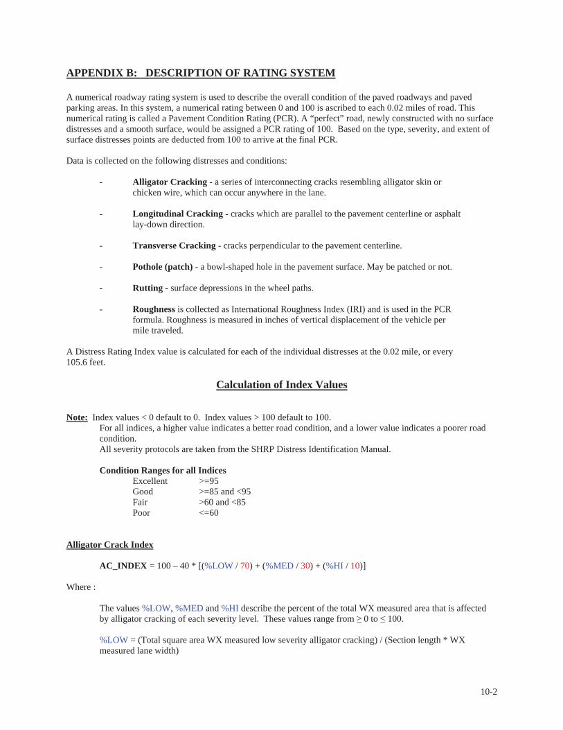
APPENDIX B: DESCRIPTION OF RATING SYSTEM
A numerical roadway rating system is used to describe the overall condition of the paved roadways and paved parking areas. In this system, a numerical rating between 0 and 100 is ascribed to each 0.02 miles of road. This numerical rating is called a Pavement Condition Rating (PCR). A “perfect” road, newly constructed with no surface distresses and a smooth surface, would be assigned a PCR rating of 100. Based on the type, severity, and extent of surface distresses points are deducted from 100 to arrive at the final PCR. Data is collected on the following distresses and conditions:
- Alligator Cracking - a series of interconnecting cracks resembling alligator skin or chicken wire, which can occur anywhere in the lane.
- Longitudinal Cracking - cracks which are parallel to the pavement centerline or asphalt lay-down direction.
- Transverse Cracking - cracks perpendicular to the pavement centerline. - Pothole (patch) - a bowl-shaped hole in the pavement surface. May be patched or not. - Rutting - surface depressions in the wheel paths. - Roughness is collected as International Roughness Index (IRI) and is used in the PCR
formula. Roughness is measured in inches of vertical displacement of the vehicle per mile traveled.
A Distress Rating Index value is calculated for each of the individual distresses at the 0.02 mile, or every 105.6 feet.
Calculation of Index Values
Note: Index values < 0 default to 0. Index values > 100 default to 100. For all indices, a higher value indicates a better road condition, and a lower value indicates a poorer road condition. All severity protocols are taken from the SHRP Distress Identification Manual.
Condition Ranges for all Indices
Excellent >=95 Good >=85 and <95 Fair >60 and <85 Poor <=60 Alligator Crack Index AC_INDEX = 100 – 40 * [(%LOW / 70) + (%MED / 30) + (%HI / 10)] Where :
The values %LOW, %MED and %HI describe the percent of the total WX measured area that is affected by alligator cracking of each severity level. These values range from 0 to 100. %LOW = (Total square area WX measured low severity alligator cracking) / (Section length * WX measured lane width)
10-2

%MED = (Total square area WX measured medium severity alligator cracking) / (Section length * WX measured lane width) %HI = (Total square area WX measured high severity alligator cracking) / (Section length * WX measured lane width)
The denominators 70, 30, and 10 are the maximum allowable extents for the numerator value in the same units. For example, low severity alligator cracking totaling 70% of the measured section area would alone fail that section of road for this index. The threshold for failure for this index is AC_INDEX = 60. Severity Levels:
Low severity alligator cracking describes an area of cracks with no or only a few connecting cracks; cracks are not spalled (cracked, broken, chipped, frayed along the cracks); pumping (water seepage from beneath the pavement through the cracks) is not evident. Any sealed alligator cracks are low severity alligator cracks, as long as the sealant is still in good condition. If the sealant has reopened, and the crack is visible and can be measured, the crack severity is assigned according to that measurement. Medium severity alligator cracking describes an area of interconnected cracks forming a complete pattern; cracks may be slightly spalled; pumping is not evident. High severity alligator cracking describes an area of moderately or severely spalled interconnected cracks forming a complete pattern; pieces may move when subjected to traffic; pumping may be evident.
Longitudinal Crack Index LC_INDEX = 100 – 40 * [(%LOW / 350) + (%MED / 200) + (%HI / 75)] Where:
The values %LOW, %MED and %HI describe the length of longitudinal cracking of each severity as a percent of the section length. These values are 0 and can exceed 100.
%LOW = (Total linear feet WX measured low severity longitudinal cracking) / (Section length in linear feet) %MED = (Total linear feet WX measured medium severity longitudinal cracking) / (Section length in linear feet) %HI = (Total linear feet WX measured high severity longitudinal cracking) / (Section length in linear feet)
The denominators 350, 200, and 75 are the maximum allowable extents for the numerator value in the same units. For example, medium severity longitudinal cracking with a total length that is 200% of the length of the section would alone fail that section of road for this index. The threshold for failure for this index is LC_INDEX = 60.
Severity Levels:
Low severity longitudinal cracks have a mean width ¼”, or are sealed cracks of indeterminate width whose sealant material is in good condition. Medium severity longitudinal cracks have a mean width > ¼” and ¾”. High severity longitudinal cracks have a mean width > ¾”.
10-3
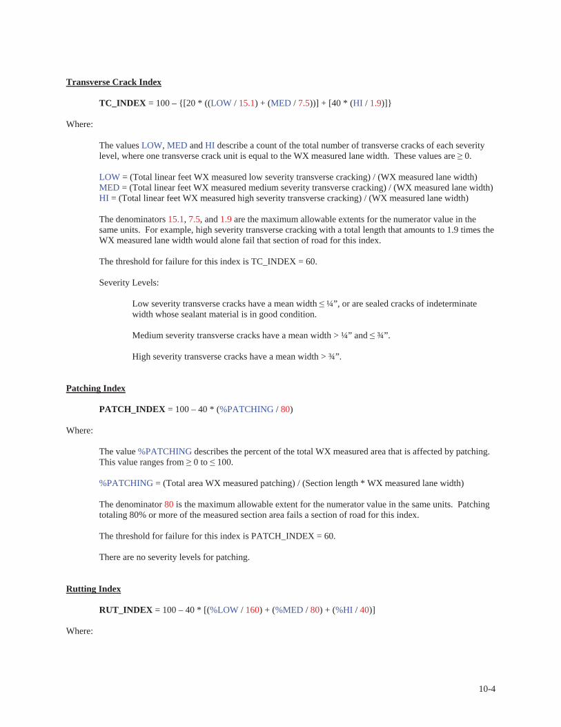
Transverse Crack Index TC_INDEX = 100 – {[20 * ((LOW / 15.1) + (MED / 7.5))] + [40 * (HI / 1.9)]} Where:
The values LOW, MED and HI describe a count of the total number of transverse cracks of each severity level, where one transverse crack unit is equal to the WX measured lane width. These values are 0. LOW = (Total linear feet WX measured low severity transverse cracking) / (WX measured lane width) MED = (Total linear feet WX measured medium severity transverse cracking) / (WX measured lane width) HI = (Total linear feet WX measured high severity transverse cracking) / (WX measured lane width)
The denominators 15.1, 7.5, and 1.9 are the maximum allowable extents for the numerator value in the same units. For example, high severity transverse cracking with a total length that amounts to 1.9 times the WX measured lane width would alone fail that section of road for this index. The threshold for failure for this index is TC_INDEX = 60.
Severity Levels:
Low severity transverse cracks have a mean width ¼”, or are sealed cracks of indeterminate width whose sealant material is in good condition. Medium severity transverse cracks have a mean width > ¼” and ¾”. High severity transverse cracks have a mean width > ¾”.
Patching Index PATCH_INDEX = 100 – 40 * (%PATCHING / 80) Where:
The value %PATCHING describes the percent of the total WX measured area that is affected by patching. This value ranges from 0 to 100. %PATCHING = (Total area WX measured patching) / (Section length * WX measured lane width) The denominator 80 is the maximum allowable extent for the numerator value in the same units. Patching totaling 80% or more of the measured section area fails a section of road for this index. The threshold for failure for this index is PATCH_INDEX = 60. There are no severity levels for patching.
Rutting Index RUT_INDEX = 100 – 40 * [(%LOW / 160) + (%MED / 80) + (%HI / 40)] Where:
10-4
10 ARAN rut depth measurements are taken per full .02 section for each of 2 wheel paths (left and right), resulting in a total of 20 measurements taken for both wheel paths. The values %LOW, %MED and %HI describe the number of ARAN rut depth measurements of both wheel paths in the section whose values are of each severity level, calculated as a percentage of the total number of ARAN rut depth measurements taken for a single wheel path in the section. These values range from 0 to 200.
%LOW = (Total number of ARAN measured low severity ruts in section for both wheel paths) / (Total number of ARAN rut measurements in section for a single wheel path) %MED = (Total number of ARAN measured medium severity ruts in section for both wheel paths) / (Total number of ARAN rut measurements in section for a single wheel path) %HI = (Total number of ARAN measured high severity ruts in section for both wheel paths) / (Total number of ARAN rut measurements in section for a single wheel path)
The denominators 160, 80, and 40 are the maximum allowable extents for the numerator value in the same units. For example, low severity ruts recorded in 16 of the 20 total readings (or 160% of a full wheel path’s worth of readings) for a full .02 section would fail that section for this index.
The threshold for failure for this index is RUT_INDEX = 60.
Severity Levels:
Ruts with an ARAN measured depth < 0.20” are not included in the distress calculations. Low severity ruts have an ARAN measured depth 0.20” and 0.49”. Medium severity ruts have an ARAN measured depth 0.50” and 0.99”. High severity ruts have an ARAN measured depth 1.00”.
Roughness Condition Index
RCI = 32 * [5 * (2.718282 ^ (-0.0041 * AVG IRI))]
Where:
The value AVG IRI describes the average value of the Left IRI and Right IRI measurements for the section. This value can range from approximately 40 to over 1000. AVG IRI = (ARAN measured Left IRI + ARAN measured Right IRI) / 2 There is no applicable threshold for failure for this index.
NOTE: Collection of roughness data is dependent on the data collection vehicle traveling at a minimum speed of 12 mph. In the event that a route cannot be safely traveled at this minimum speed, and results in no roughness data, the SCR only will be calculated. Surface Condition Rating Index
SCR = 100 - [(100 - AC_INDEX) + (100 - LC_INDEX) + (100 - TC_INDEX) + (100 - PATCH_INDEX) + (100 - RUT_INDEX)]
Where:
10-5
See above for determinations of AC_INDEX, LC_INDEX, TC_INDEX, PATCH_INDEX and RUT_INDEX.
The threshold for failure for this index is SCR = 60.
Pavement Condition Rating Index Asphaltic Concrete Pavement (AS) PCR = (0.60 * SCR) + (0.40 * RCI) Where: See above for determinations of SCR and RCI. The values 0.60 and 0.40 function as weights within the formula.
If SCR equals zero (which means that the road surface condition is very poor), then the formula simply reduces to: PCR = 0.40 * RCI.
If RCI equals zero (which means that this value was not available for some reason), then the formula becomes: PCR = SCR. The threshold for failure for this index is PCR = 60.
Pavement Condition Rating Index Portland Cement Concrete Pavement (CO) Concrete PCR = -0.0012(IRI^2)+0.0499(IRI)+99.542 Where:
The threshold for failure for this index is PCR = 60.
Parking Lot and Manually Rated Road Condition Rating
Surface Condition Distresses- Chip Seal:Raveling – loss of surface rock chips revealing previous surface Bleeding – asphalt or tar is bleeding through to the surface where surface looks slick with asphalt Rutting Potholes/Patching
Ratings - Chip Seal:Excellent – None of the surface affected by the above (recently constructed) Good – Less than 10% of surface affected by the above Fair – Between 10% and 40% of surface affected by the above Poor – More than 40% of surface affected by the above
Surface Condition - Asphalt:Cracking of any type Rutting Potholes/Patching
10-6

Ratings - Asphalt:Excellent – None of the surface affected by the above (recently constructed) Good – Less than 10% of surface affected by the above Fair – Between 10% and 40% of surface affected by the above Poor – More than 40% of surface affected by the above
Index Values of Visual Ratings on Parking Lots and Manually Rated Roads Under Construction 100
Excellent 97
Good 90
Fair 73
Poor 45
10-7

APPENDIX C: GENERAL INFORMATION ON RIP SYSTEMS
DMI (Distance Measuring Instrument) The DMI (Distance Measuring Instrument) obtains road length measurements that are highly accurate (to 0.001 miles). The DMI is connected to the outside of the rear wheel on the driver’s side, and is wired into the antilock braking system (ABS). The number of pulses recorded for each wheel rotation by the ABS is registered by the DMI, which transmits a measurement of distance traveled to the processing computers in the ARAN. The DMI distance measurements are the foundation to which all the other subsystems are tied.
Digital Image InformationAll images collected in Cycle 4 are digital images in .jpg format. These images provide adequate resolution for identifying sign and feature inventories and pavement evaluations. The images can be viewed with an interactive software program called VisiData. Each park will receive a copy of the VisiData program. Cycle 4 data, as well as Cycle 3 data, can be viewed using the Visi-Data software program. This program is a data presentation and analysis tool that can be accessed either at the individual park, park region or at NPS headquarters. The data is organized in a hierarchical manner and presented in tabular and graphical formats. The user is able to perform queries and drill down through the data to find the particular information they are looking for. Associated digital right-of-way images from either the LAN, USB port, individual DVD can be presented along with GPS locations.
Right-of-way (ROW) Video Three digital cameras are mounted above the vehicle’s windshield that point directly forward and slightly to the left and right. These cameras each collect one image every 0.002 miles (10.56 feet) in the primary-direction lane, to give a panoramic field-of-view of about 160 degrees. (Forward-facing video from the center camera only is collected in the opposite-direction lane of travel.) If data collection speed exceeds 35-40 mph, the network and storage computers may become overwhelmed and may begin to drop individual video frames. Occasional common video quality issues include sun glare and rapid changes between sunlight and shadow. The camera system is equipped with auto risers that sometimes cannot adjust quickly enough to collect optimal video images.
FHWA ARAN CAMERA SPECIFICATIONSForward-Facing Cameras (ROW)Focal length 10 mm Chip size 8.71mm X 6.90mmNaming convention of each image chainage.jpg Image resolution 1300 X 1030 Image pixel size depends on distance Relative position of the GPS unit to each camera
2.104 meters from front-center rutbar to camera
The ARAN has a lever arm setting which tells the POS system where the center of the rutbar is with respect to the GPS antennas.
Pavement Video Pavement video images are collected by the data collection vehicle to use in later analysis to determine extents and severities of different types of pavement distress. The pavement in the primary-direction road lane is filmed continuously by two analog cameras attached to booms extended from the rear of the ARAN on the left and right sides. Strobe lights fire synchronously with the opening of the camera shutters to eliminate shadows and motion blur. The images from the two cameras overlap, and are stitched together in real time to create a continuous strip image of the pavement in the primary direction lane. This strip has a maximum width of 3.0 meters (actual width depends on pavement camera calibration) and is sectioned for ease of file management every 0.010 miles (52.8 feet).
10-8
The cameras both have a resolution of 640 x 480, making the threshold of visible pavement cracks about 3 mm. Because the cameras are triggered by time and not distance traveled, this subsystem requires a minimum operating speed of 6 mph, otherwise images are taken on top of one another and result in checkered or black pavement video.
FHWA ARAN CAMERA SPECIFICATIONSPavement Cameras Image Pixel size 3.135 mm /side Image Resolution 640 X 480 Area that images cover 1.5 m X 1.2 m Full color or grayscale grayscale Vehicle speed limitations 80km/h Aperture setting Auto-iris Exposure setting 1/50000
FHWA ARAN GPS & Inertial SystemGPS is collected by a NovAtel MiLLenium, 12 channel, dual frequency L1/L2, DGPS ready receiver with a MiLLennium 502 GPS antenna. An OmniStar 3000 LR provides real-time differential correction. An Applanix POS/LV is the inertial system that fills in when GPS is unavailable. The antenna is mounted in the center of the roof, slightly toward the rear of the vehicle, but a lever arm is applied to place the operational location of GPS recording at the center of the rutbar on the front bumper of the vehicle. Expected accuracy under ideal conditions is sub meter. GPS Collected on Manually Rated Routes Parking areas and roads that are not fully drivable with the ARAN data collection vehicle are collected manually by field technicians. GPS is collected for these routes using GPS field data collection utilizes Trimble ProXRS or ProXH Receivers matched with Trimble TSC1 or Ranger handheld Data Loggers, connected to Trimble Hurricane Antennas giving sub meter accuracy in ideal conditions. This collection equipment has varied as technology has improved over the years of RIP data collection. Some GPS files collected as early as 1998 have been verified for accuracy and perpetuated through the current cycle of data collection. GPS SHAPEFILES Type of Route and CollectionShape Filename
Roads driven by ARAN Line park_road_04.dbf/.shp/.shx Parking Areas Polygon park_pkg_04.dbf/.shp/.shx Roads Manually Rated as Lines (not in every park)
Line park_mrl_04.dbf/.shp/.shx
Roads Manually Rated as Polygons (not in every park)
Polygon park_mrp_04.dbf/.shp/.shx
• Datum for all GPS shapefiles is LL_WGS84_DD (Latitude Longitude _World Geodetic Survey 1984_Decimal Degrees) • In filename, “park” is NPS four-letter alphabetic code. • The source for route data required for data processing and report production is the PARK_RouteInfo.mdb.
10-9
Condition Photos Taken of Manually Rated Roads One or more digital photos are taken by Canon Power Shot G2 4.0 Mega Pixel digital camera for each manually rated route in a National Park. They are stored in .jpg format named with the four-letter NPS park alphabetic code, route number, and the photo number assigned by the camera. For example, YOSE_0900_4434.jpg is the filename of the photo named 4434 by the camera that was taken of Yosemite National Park route 0900. Scenic Photos Scenic photos are taken by Canon Power Shot G2 4.0 Mega Pixel digital camera throughout each park and are named with the four-letter NPS park alphabetic code and the count of the photo taken in that park. For example, GRCA003.jpg is the filename of the third scenic photo taken in Grand Canyon National Park. The number of scenic photos provided will vary between parks.
10-10

APPENDIX D: METADATA
FHWA – NPS Road Inventory Program Cycle 4 Metadata The purpose of these sheets is to provide users of the Road Inventory Program’s data with data accuracies and tolerances to help users define ways in which the RIP data can and cannot be used. For further information on specifics of data collection equipment, data collection procedures, equipment calibrations, or quality control/quality assurance procedures, please contact Jim Kennedy, Project Manager, Data Quality Assurance, at 720-963-3560 or [email protected]. All Road Inventory Program data undergoes quality control and quality assurance testing. This document represents the known data accuracies and tolerances for the data collection equipment, data collection procedures, and data processing procedures currently in use. Many additional tests conducted on the park databases during the quality assurance phase to ensure data integrity are not listed as a part of this document. Before it is delivered, a park database undergoes a large set of table design consistency, field data format consistency, data completeness, uniqueness of key fields, data reasonableness, acceptable data range, within-field data consistency, between-field data consistency, and between-table data consistency tests. Additional data sampling checks are conducted to ensure proper data upload from raw files into the park database and to quality check the pavement crack analysis. Further information is detailed in the FHWA – NPS RIP Quality Assurance Manual, available upon request. This description of metadata includes only the known accuracies with which a data field matches its expected value. The tables that follow this page show each database field’s:
Field – field name Format – data type and number of characters of field Expected Value – meaning of value assigned to field Source – when in process field value obtained Validation – how field value obtained Expected Accuracy – accuracy with which contents of field match Expected Value
Verifying and continually improving the accuracy of Road Inventory Program data is an ongoing goal of the Federal Highway Administration and the National Park Service. Field testing and post-collection analysis of ARAN (Automatic Road ANalyzer) -collected data will continue in Cycle 4. Data quality is expected to improve as the FHWA – NPS Road Inventory Program continues to operate, due to the fact that future data collection cycles will consist in large part of data updates. Also, technological improvements are expected to render the data increasingly consistent with actual roadway conditions as data collection cycles progress.
Specific Caveats
MUTCD based on contents & colors of sign, not on size Database records that show a Portland Cement Concrete (CO) surface type sometimes include distress index values that seem to show a perfect roadway. Condition assessments on concrete pavements are not conducted for Alligator Cracking, Transverse or Longitudinal Cracking, Patching, or Rutting. Perfect values for concrete road sections for these indexes are default values and do not represent a condition assessment of the concrete surfaces. On the USB drive, in the Database folder, parks are provided with intersection lists and exceptions lists. These documents should be treated as raw files and are not accurate. Refer to the final database for accurately post-processed intersection data. Most roadway data is collected in the primary direction lane of a roadway. To save data storage space and to reduce data analysis efforts, the assumption was made that the paved surface condition of a route’s primary lane adequately represents the surface condition of the full roadway. Therefore, in the database, opposite-direction records in the PMS_Tenth table do not include assessed values for roadway surface distresses. Values such as 0, N/A, -1, or a repeat of the primary-direction assessed value indicate that no assessment was performed. The PMS_20 and PMS_Mile tables simply exclude all opposite routes.
10-11
10-12
Roadway Data is collected in intervals of 0.010 miles (52.8feet) constituting a “station”. Most roadway features are collected relative to the primary direction lane of a roadway, using the primary-direction video and mileage. Signs and Mile Markers are the only features collected using the opposite-direction video with mileage location referenced to the primary direction lane of the roadway. Route_GPS table contains GPS positional information collected by the ARAN and post processed with Applanix POSPac Land 5.0 post-processing software. No manual adjustments have occurred on this table. Modifications to the Park_ROAD_04.dbf/.shp/.shx files may have been necessary for report esthetics. Modifications to the Park_PKG_04. dbf/.shp/.shx files may have been necessary for report esthetics. Cycle 4 utilizes the Microsoft Office 2003 suite of products and Crystal Reports XI for document and data file generation and reporting. All PDF files are in Adobe Acrobat 7.0 Professional format. All ArcGIS files are created using ESRI Version 9.x software. Thumbnail images are created at 1/10 original image size for Right-of-Way and Pavement Images. FHWA is investigating the rutting methodology and calculated values it currently reports. Equipment limitations and analysis methods may be over reporting, low severity rutting.
Key to Notes in Tables
(1): Note that only one value fits in field, so even if this value varies throughout the route, only predominant value is recorded here. (2): Shoulder width is measured at route start and every half-mile along the route in the primary direction. Width is the entire width of the drivable shoulder, regardless of the presence or absence of pavement, from the fog line to the shoulder hinge point, or if no fog line exists, from the edge of pavement to the hinge point. Identification of shoulder hinge point can be problematic using video analysis. Some paved ditches may be mistakenly recorded as shoulders where the shoulder hinge point and change in slope are not easily distinguished from the video. (3): Mileage is measured by the ARAN (Automatic Road ANalyzer) data collection vehicle out to the 0.001 decimal place. The DMI (distance measuring instrument) is very accurate, with extremely slight variations in measurement due to air temperature, tire inflation, curves, hills, and equipment calibration. (4): Features are measured differently depending on whether they are visible in the forward-facing video of the roadway, but every feature milepost measurement depends on the baseline measurement of the data collection vehicle’s mileage. The ARAN (Automatic Road ANalyzer) data collection vehicle’s mileage is measured by the DMI (distance measuring instrument) out to the 0.001 decimal place. The DMI is very accurate, with extremely slight variations in measurement due to air temperature, tire inflation, curves, hills, and equipment calibration. If a feature will not be visible in the forward-facing video, its milepost is determined by the data collectors’ key press tagging the milepost when the ARAN passes the feature. Key presses are entered into the ARAN software when the vehicle travels typically between 15 and 45 miles/hour, so a delay of a single second as the vehicle passes a feature would result in an inaccuracy of 0.004 miles (22 feet) to 0.012 miles (66 feet). If a feature is visible in the video, its milepost is determined during post-processing using a video measurement software called Surveyor. (5): Condition assessments on concrete (PCC) pavements are not conducted for Alligator Cracking, Transverse or Longitudinal Cracking, Patching, or Rutting. Perfect values for concrete road sections for these indexes are default values and do not represent a condition assessment of the concrete surfaces. (6): Roadway cracking presence, type, severity, and extent are determined by filming the roadway in the primary lane continuously with two overlapping analog cameras of 640 x 480 resolutions. The images from both cameras are stitched together in real time to create a continuous strip image of the roadway pavement in the primary lane. Cracks 3 mm or greater in width are visible in this video. A semi-automatic process running the WiseCrax software with additional input by human operators provides the cracking quantities recorded in these database fields. Quality checks have determined that a consistent 80% or better of the visible cracks are recorded.
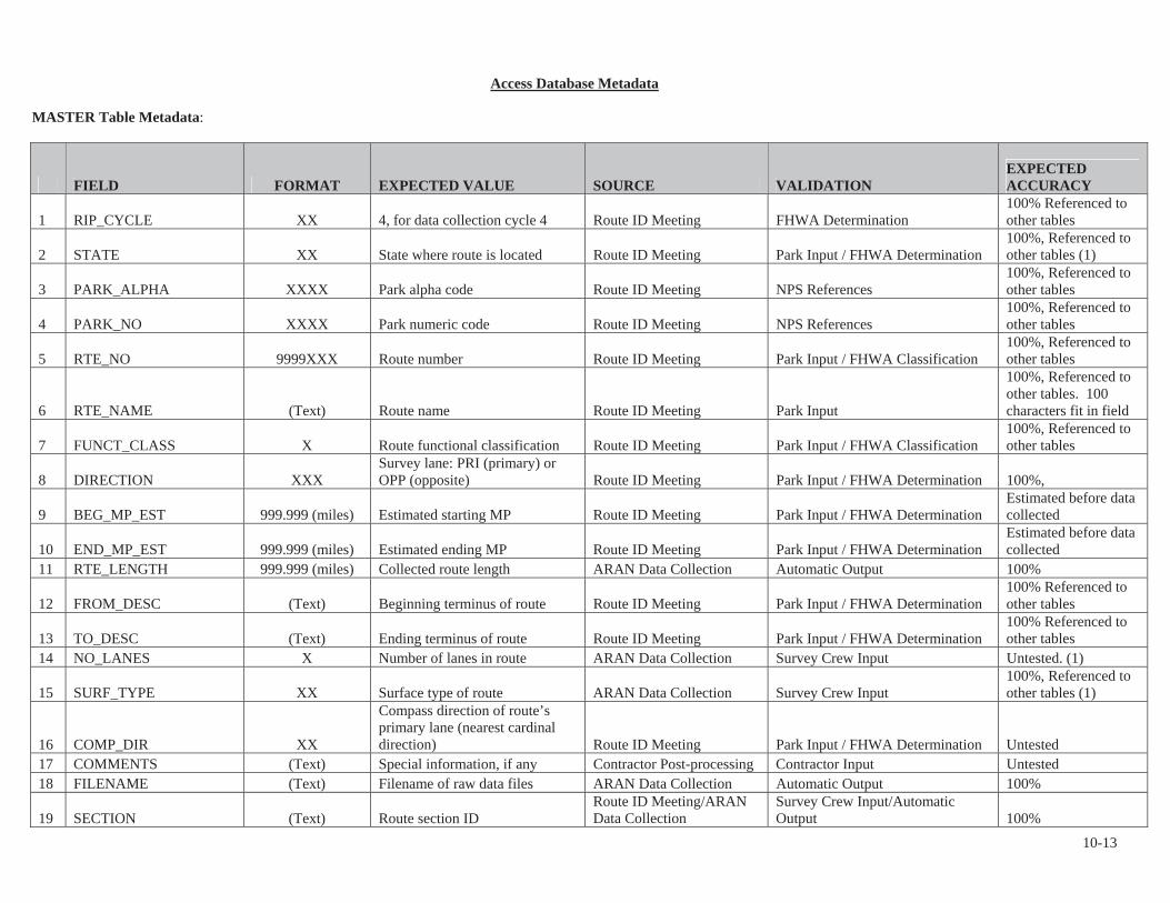
Access Database Metadata MASTER Table Metadata:
FIELD FORMAT EXPECTED VALUE SOURCE VALIDATIONEXPECTEDACCURACY
1 RIP_CYCLE XX 4, for data collection cycle 4 Route ID Meeting FHWA Determination 100% Referenced to other tables
2 STATE XX State where route is located Route ID Meeting Park Input / FHWA Determination 100%, Referenced to other tables (1)
3 PARK_ALPHA XXXX Park alpha code Route ID Meeting NPS References 100%, Referenced to other tables
4 PARK_NO XXXX Park numeric code Route ID Meeting NPS References 100%, Referenced to other tables
5 RTE_NO 9999XXX Route number Route ID Meeting Park Input / FHWA Classification 100%, Referenced to other tables
6 RTE_NAME (Text) Route name Route ID Meeting Park Input
100%, Referenced to other tables. 100 characters fit in field
7 FUNCT_CLASS X Route functional classification Route ID Meeting Park Input / FHWA Classification 100%, Referenced to other tables
8 DIRECTION XXXSurvey lane: PRI (primary) or OPP (opposite) Route ID Meeting Park Input / FHWA Determination 100%,
9 BEG_MP_EST 999.999 (miles) Estimated starting MP Route ID Meeting Park Input / FHWA Determination Estimated before data collected
10 END_MP_EST 999.999 (miles) Estimated ending MP Route ID Meeting Park Input / FHWA Determination Estimated before data collected
11 RTE_LENGTH 999.999 (miles) Collected route length ARAN Data Collection Automatic Output 100%
12 FROM_DESC (Text) Beginning terminus of route Route ID Meeting Park Input / FHWA Determination 100% Referenced to other tables
13 TO_DESC (Text) Ending terminus of route Route ID Meeting Park Input / FHWA Determination 100% Referenced to other tables
14 NO_LANES X Number of lanes in route ARAN Data Collection Survey Crew Input Untested. (1)
15 SURF_TYPE XX Surface type of route ARAN Data Collection Survey Crew Input 100%, Referenced to other tables (1)
16 COMP_DIR XX
Compass direction of route’s primary lane (nearest cardinal direction) Route ID Meeting Park Input / FHWA Determination Untested
17 COMMENTS (Text) Special information, if any Contractor Post-processing Contractor Input Untested 18 FILENAME (Text) Filename of raw data files ARAN Data Collection Automatic Output 100%
19 SECTION (Text) Route section ID Route ID Meeting/ARAN Data Collection
Survey Crew Input/Automatic Output 100%
10-13
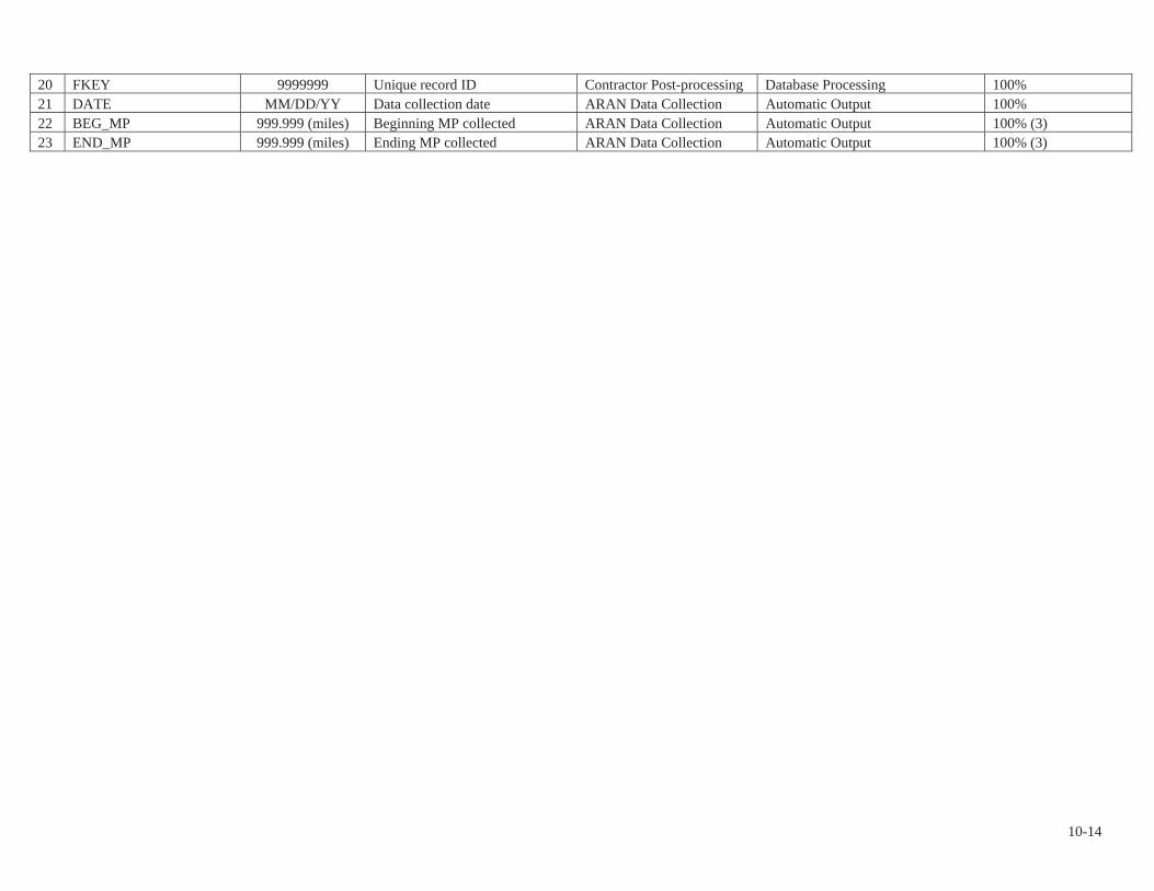
20 FKEY 9999999 Unique record ID Contractor Post-processing Database Processing 100% 21 DATE MM/DD/YY Data collection date ARAN Data Collection Automatic Output 100% 22 BEG_MP 999.999 (miles) Beginning MP collected ARAN Data Collection Automatic Output 100% (3) 23 END_MP 999.999 (miles) Ending MP collected ARAN Data Collection Automatic Output 100% (3)
10-14

PMS_FEATURE Table Metadata:
FIELD FORMAT EXPECTED VALUE SOURCE VALIDATIONEXPECTEDACCURACY
1 RIP_CYCLE XX 4, for data collection cycle 4 Route ID Meeting FHWA Determination
100% Referenced to other tables
2 STATE XX State where route is located Route ID Meeting
Park Input / FHWA Determination Untested (1)
3 PARK_ALPHA XXXX Park alpha code Route ID Meeting NPS References 100% Referenced to other tables
4 PARK_NO XXXX Park numeric code Route ID Meeting NPS References 100% Referenced to other tables
5 RTE_NO 9999XXX Route number Route ID Meeting Park Input / FHWA Classification
100% Referenced to other tables
6 FMSS_EQUIP XXXXXXX
Facility Management Software System Equipment number NPS FMSS application NPS References Untested
7 FUNCT_CLASS X Route functional class Route ID Meeting Park Input / FHWA Classification
100% Referenced to other tables
8 DIRECTION XXXSurvey lane: PRI (primary) or OPP (opposite) Route ID Meeting
Park Input / FHWA Determination 100%
9 MP 999.999 (miles) Feature location along route
ARAN Data Collection/Contractor Post-processing Video Analysis <=0.001 mile
10 BEG_MP 999.999 (miles)Feature Beginning location along route Contractor Post-processing Video Analysis <=0.001 mile
11 END_MP 999.999 (miles)Feature Ending location along route Contractor Post-processing Video Analysis <=0.001 mile
12 FEATURE_LENGTH 999.99 (Feet) Linear Feature Length Contractor Post-processing Database Processing 100% 13 EVENT XXXX Event category of feature Contractor Post-processing Video Analysis Untested
14 EVENT_CODE XXXXEvent sub-category of feature Contractor Post-processing Video Analysis Untested
15 FEATURE_TYPE (Text)Feature designation: LINEAR or POINT Contractor Post-processing Video Analysis Untested
16 EVENT_DESC (Text)Description of feature/contents of sign Contractor Post-processing Video Analysis Untested
17 MUTCD (Text) MUTCD Code of Sign Contractor Post-processing Database Processing 95%
18 CONDITION “N/A”Sign condition. N/A. Not to be populated Contractor Post-processing Video Analysis
Values inaccurate, defaulted to “N/A”
19 COMMENT (Text)Sign label, intersecting route, etc. Contractor Post-processing Database Processing Untested
20 OFFSET “N/A”Offset from Road Edge. N/A. Not to be populated Contractor Post-processing Database Processing
Values inaccurate, defaulted to “N/A”
10-15

FIELD FORMAT EXPECTED VALUE SOURCE VALIDATIONEXPECTEDACCURACY
21 SIDE (Text)Side of route relative to lane driven Contractor Post-processing Video Analysis 95%
22 STR_NUMBER (Text)FHWA bridge structure number FHWA Post-processing Database Processing Untested
23 BARR_MAT (Text) Barrier Material Type Contractor Post-processing Video Analysis Untested 24 BARR_TYPE (Text) Barrier Type Contractor Post-processing Video Analysis Untested 25 BARR_POST_MAT (Text) Barrier Post Materials Contractor Post-processing Video Analysis Untested 26 BARR_BEG_TERM (Text) Barrier Approach Treatment Contractor Post-processing Video Analysis Untested 27 BARR_END_TERM (Text) Barrier End Treatment Contractor Post-processing Video Analysis Untested 28 CURB_MAT (Text) Curb Material Type Contractor Post-processing Video Analysis Untested 29 PAVED_DITCH_MAT (Text) Paved Ditch Material Type Contractor Post-processing Video Analysis Untested (2) 30 GATE_MAT (Text) Gate Material Type Contractor Post-processing Video Analysis Untested 31 GATE_STYLE (Text) Gate Style Contractor Post-processing Video Analysis Untested
32 BEG_GPS_LAT 999.999999GPS Latitude Co-ordinate (decimal degrees) Contractor Post-processing Video Analysis <= 3.00 feet
33 BEG_GPS_LON -999.999999GPS Longitude Co-ordinate (-decimal degrees) Contractor Post-processing Video Analysis <= 3.00 feet
34 BEG_GPS_ELEV 99999.9 GPS Elevation Feet Contractor Post-processing Video Analysis Untested 35 BEG_GPS_MODE (Text) GPS Satellite Mode Contractor Post-processing Video Analysis Untested
36 END_GPS_LAT 999.999999GPS Latitude Co-ordinate (decimal degrees) Contractor Post-processing Video Analysis <= 3.00 feet
37 END_GPS_LON -999.999999GPS Longitude Co-ordinate (-decimal degrees) Contractor Post-processing Video Analysis <= 3.00 feet
38 END_GPS_ELEV 99999.9 GPS Elevation Feet Contractor Post-processing Video Analysis Untested 39 END_GPS_MODE (Text) GPS Satellite Mode Contractor Post-processing Video Analysis Untested 40 DATUM (Text) LL_WGS84_DD Contractor Post-processing Database Processing 100%
41 VIDEO <Park>C04VID<#> Removable USB video hard drive number Contractor Post-processing Database Processing Untested
42 IMAGE (Text)Filename of .jpg image showing feature Contractor Post-processing Automatic Output Untested
43 DATE MM/DD/YY Data collection date ARAN Data Collection Automatic Output 100% 44 FILENAME (Text) Filename of raw data files ARAN Data Collection Automatic Output 100%
45 SECTION (Text) Route section ID Route ID Meeting/ARAN Data Collection
Survey Crew Input/Automatic Output 100%
46 FKEY (Numeric) Unique record ID Contractor Post-processing Database Processing 100%
47 VISI_FROM 999999 (millimiles)Raw MP of first video frame showing feature Contractor Post-processing Database Processing Untested
48 VISI_TO 999999 (millimiles)Raw MP of last video frame showing feature Contractor Post-processing Database Processing Untested
10-16

FIELD FORMAT EXPECTED VALUE SOURCE VALIDATIONEXPECTEDACCURACY
49 IDKEY (Text)Unique record ID used by VisiData Contractor Post-processing Database Processing Untested
50 MP_REF (Text)Range of mileage to play in VisiData Contractor Post-processing Database Processing Untested
List of Roadway Features # EVENT EVENT_CODE FEATURE_TYPE EVENT_DESC STRUCTURE # COLLECTED BY
1 BRIDGE BRDG LINEAR BRIDGE ALWAYS ARAN
2 CATTLE GUARD CGD POINT CATTLE GUARD - VIDEO RATING
3 CONSTRUCTION CNST LINEARCONSTRUCTION WORK
ZONE - ARAN
4 CULVERT CUL POINT CULVERT SOMETIMES ARAN
5 CURB CRBL LINEAR CURB ON LEFT - VIDEO RATING
"" CRBR LINEAR CURB ON RIGHT - VIDEO RATING
6 CURB-AND-
GUTTER CAGL LINEARCURB-AND-GUTTER ON
LEFT - VIDEO RATING
"" CAGR LINEAR CURB-AND-GUTTER ON
RIGHT - VIDEO RATING
7 DROP INLET DINL POINT DROP INLET ON LEFT - ARAN
"" DINR POINT DROP INLET ON RIGHT - ARAN
8 GATE GATE POINT GATE - VIDEO RATING
9 FIRE HYDRANT FHDL POINTFIRE HYDRANT ON
LEFT - VIDEO RATING
"" FHDR POINT FIRE HYDRANT ON
RIGHT - VIDEO RATING
10 GUARD/GUIDE
WALL GGWL LINEARGUARD/GUIDE WALL
ON LEFT - VIDEO RATING
"" GGWR LINEAR GUARD/GUIDE WALL
ON RIGHT - VIDEO RATING
11 GUARD/GUIDE
RAIL GGRL LINEARGUARD/GUIDE RAIL ON
LEFT - VIDEO RATING
"" GGRR LINEAR GUARD/GUIDE RAIL ON
RIGHT - VIDEO RATING
12 INTERSECTION INTL POINT INTERSECTION ON LEFT - ARAN
"" INTR POINT INTERSECTION ON
RIGHT - ARAN
"" INTN POINT INTERSECTION SIDE N/A - ARAN
10-17
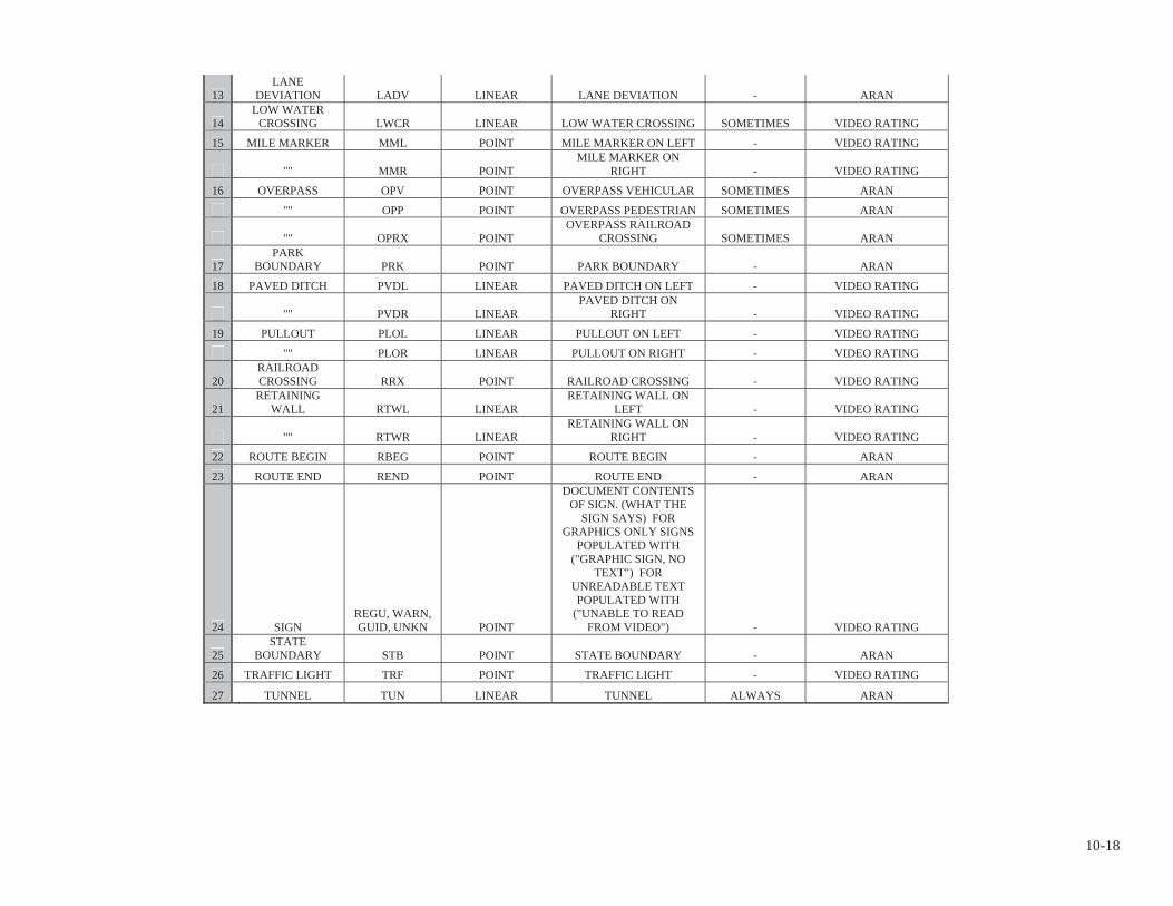
13 LANE
DEVIATION LADV LINEAR LANE DEVIATION - ARAN
14 LOW WATER
CROSSING LWCR LINEAR LOW WATER CROSSING SOMETIMES VIDEO RATING
15 MILE MARKER MML POINT MILE MARKER ON LEFT - VIDEO RATING
"" MMR POINT MILE MARKER ON
RIGHT - VIDEO RATING
16 OVERPASS OPV POINT OVERPASS VEHICULAR SOMETIMES ARAN
"" OPP POINT OVERPASS PEDESTRIAN SOMETIMES ARAN
"" OPRX POINT OVERPASS RAILROAD
CROSSING SOMETIMES ARAN
17 PARK
BOUNDARY PRK POINT PARK BOUNDARY - ARAN
18 PAVED DITCH PVDL LINEAR PAVED DITCH ON LEFT - VIDEO RATING
"" PVDR LINEAR PAVED DITCH ON
RIGHT - VIDEO RATING
19 PULLOUT PLOL LINEAR PULLOUT ON LEFT - VIDEO RATING
"" PLOR LINEAR PULLOUT ON RIGHT - VIDEO RATING
20 RAILROAD CROSSING RRX POINT RAILROAD CROSSING - VIDEO RATING
21 RETAINING
WALL RTWL LINEARRETAINING WALL ON
LEFT - VIDEO RATING
"" RTWR LINEAR RETAINING WALL ON
RIGHT - VIDEO RATING
22 ROUTE BEGIN RBEG POINT ROUTE BEGIN - ARAN
23 ROUTE END REND POINT ROUTE END - ARAN
24 SIGNREGU, WARN, GUID, UNKN POINT
DOCUMENT CONTENTS OF SIGN. (WHAT THE
SIGN SAYS) FOR GRAPHICS ONLY SIGNS
POPULATED WITH ("GRAPHIC SIGN, NO
TEXT") FOR UNREADABLE TEXT POPULATED WITH
("UNABLE TO READ FROM VIDEO") - VIDEO RATING
25 STATE
BOUNDARY STB POINT STATE BOUNDARY - ARAN
26 TRAFFIC LIGHT TRF POINT TRAFFIC LIGHT - VIDEO RATING
27 TUNNEL TUN LINEAR TUNNEL ALWAYS ARAN
10-18

PMS_20, PMS_MILE, & PMS_TENTH Tables Metadata:
FIELD FORMAT EXPECTED VALUE SOURCE VALIDATION EXPECTED ACCURACY
1 RIP_CYCLE XX4, for RIP data collection Cycle 4 Route ID Meeting FHWA Determination
100% Referenced to other tables
2 STATE XX State where route is located Route ID Meeting Park Input/FHWA Determination Untested. (1)
3 PARK_ALPHA XXXX Park alpha code Route ID Meeting NPS References 100% Referenced to other tables
4 PARK_NO XXXX Park numeric code Route ID Meeting NPS References 100% Referenced to other tables
5 RTE_NO 9999XXX Route number Route ID Meeting Park Input/FHWA Classification
100% Referenced to other tables
6 FUNCT_CLASS X Route functional class Route ID Meeting Park Input/FHWA Classification
100% Referenced to other tables
7 DIRECTION XXXSurvey lane: PRI (primary) or OPP (opposite) Route ID Meeting
Park Input/FHWA Determination 100%
8 BEG_MP 999.999 (miles)
MP at start of road interval described by database record Contractor Post-processing Database Processing 100% (3)
9 END_MP 999.999 (miles)
MP at end of road interval described by database record Contractor Post-processing Database Processing 100% (3)
10 INT_LENGTH 999.9 (ft)Length of road interval as aggregated for data table Contractor Post-processing Database Processing 100%
11 RTE_LENGTH 999.999 (miles) Collected route length ARAN Data Collection Automatic Output 100% (3) 12 NO_LANES 99 Number of lanes in route ARAN Data Collection Survey Crew Input Untested. (1) 13 LANE_NO 99 Data collection lane Contractor Post-processing Database Processing Untested
14 D_LANE_WIDTH 99.999 (ft)WiseCrax (crack detection software) analysis width Contractor Post-processing Automatic Output Untested
15 LANE_WIDTH 99.9 (ft) Width of lane Contractor Post-processing Video Analysis 95%, <=1.0 foot 16 PAVE_WIDTH 99.9 (ft) Full pavement width Contractor Post-processing Video Analysis 95%, <=1.0 foot 17 SHLD_WIDTH_L 99.9 (ft) Left shoulder width Contractor Post-processing Video Analysis 95%, <=1.0 foot (2) 18 SHLD_WIDTH_R 99.9 (ft) Right shoulder width Contractor Post-processing Video Analysis 95%, <=1.0 foot (2)
19 SHLD_COND_L N/AN/A. Intended to be Left shoulder condition ARAN Data Collection Survey Crew Input
Values inaccurate, defaulted to “N/A”
20 SHLD_COND_R N/AN/A. Intended to be Right shoulder condition ARAN Data Collection Survey Crew Input
Values inaccurate, defaulted to “N/A”
21 DRAIN_COND_L N/AN/A. Intended to be Left drainage condition ARAN Data Collection Survey Crew Input
Values inaccurate, defaulted to “N/A”
22 DRAIN_COND_R N/AN/A. Intended to be Right drainage condition ARAN Data Collection Survey Crew Input
Values inaccurate, defaulted to “N/A”
10-19

FIELD FORMAT EXPECTED VALUE SOURCE VALIDATION EXPECTED ACCURACY23 SURF_TYPE XX Surface type of route ARAN Data Collection Survey Crew Input Untested. (1) 24 PCR 999 Pavement Condition Rating Contractor Post-processing Database Processing 100% for calculation (6)
25 RCI 999Roughness Condition Index; -1 if invalid IRI Contractor Post-processing Database Processing 100% for calculation
26 SCR 999 Surface Condition Rating Contractor Post-processing Database Processing 100% for calculation (5) (6) 27 IRI_AVG 999.9 (inches/mile) Average IRI Contractor Post-processing Database Processing Untested 28 IRI_SD 999.9 (inches/mile) IRI standard deviation Contractor Post-processing Database Processing Untested 29 IRI_L 999.9 (inches/mile) Left wheel path IRI ARAN Data Collection Automatic Output Untested 30 IRI_R 999.9 (inches/mile) Right wheel path IRI ARAN Data Collection Automatic Output Untested 31 IRI_FLAG 0 or -1 -1 if invalid IRI data Contractor Post-processing Database Processing Untested 32 RUT_INDEX 999 Rut index Contractor Post-processing Database Processing 100% for calculation (5)
33 RUT_AVG 99.99 (inches)Average rut depth of both wheelpaths Contractor Post-processing Database Processing Untested (5)
34 RUT_MAX 99.99 (inches)Maximum rut depth of both wheelpaths Contractor Post-processing Database Processing Untested (5)
35 RUT_SD 9.9 Rut depth standard deviation Contractor Post-processing Database Processing Untested (5)
36 RUT_LOW 999 (%)
Percent of low severity ruts (on a 0-200% scale) in both wheelpaths Contractor Post-processing Database Processing Untested (5)
37 RUT_MED 999 (%)
Percent of medium severity ruts (on a 0-200% scale) in both wheelpaths Contractor Post-processing Database Processing Untested (5)
38 RUT_HI 999 (%)
Percent of high severity ruts (on a 0-200% scale) in both wheelpaths Contractor Post-processing Database Processing Untested (5)
39 XFALL 999.9 (% slope)Cross fall at start of road interval ARAN Data Collection Automatic Output Untested
40 GRADE 999.9 (% slope)Grade at start of road interval ARAN Data Collection Automatic Output Untested
41 AC_INDEX 999 Alligator cracking index Contractor Post-processing Database Processing 100% for calculation (5) (6)
42 AC_LOW 999.9999 (%)
Percent of WiseCrax measured lane area with low-severity alligator cracking Contractor Post-processing Pavement Video Analysis
As a Computed 95% Confidence Level (5) (6)
43 AC_MED 999.9999 (%)
Percent of WiseCrax measured lane area with medium-severity alligator cracking Contractor Post-processing Pavement Video Analysis
As a Computed 95% Confidence Level (5) (6)
44 AC_HI 999.9999 (%)
Percent of WiseCrax measured lane area with high-severity alligator Contractor Post-processing Pavement Video Analysis
As a Computed 95% Confidence Level (5) (6)
10-20

FIELD FORMAT EXPECTED VALUE SOURCE VALIDATION EXPECTED ACCURACYcracking
45 LC_INDEX 999 Longitudinal cracking index Contractor Post-processing Database Processing 100% for calculation (5) (6)
46 LC_LOW 999.99 (%)
Low-severity longitudinal cracking in lane as a percentage of road interval length Contractor Post-processing Pavement Video Analysis
As a Computed 95% Confidence Level (5) (6)
47 LC_MED 999.99 (%)
Medium-severity longitudinal cracking in lane as a percentage of road interval length Contractor Post-processing Pavement Video Analysis
As a Computed 95% Confidence Level (5) (6)
48 LC_HI 999.99 (%)
High-severity longitudinal cracking in lane as a percentage of road interval length Contractor Post-processing Pavement Video Analysis
As a Computed 95% Confidence Level (5) (6)
49 TC_INDEX 999 Transverse cracking index Contractor Post-processing Database Processing 100% for calculation (5) (6)
50 TC_LOW 999.99 (cracks)
Count of low-severity transverse cracks, where one crack unit equals the WiseCrax measured lane width Contractor Post-processing Pavement Video Analysis
As a Computed 95% Confidence Level (5) (6)
51 TC_MED 999.99 (cracks)
Count of medium-severity transverse cracks, where one crack unit equals the WiseCrax measured lane width Contractor Post-processing Pavement Video Analysis
As a Computed 95% Confidence Level (5) (6)
52 TC_HI 999.99 (cracks)
Count of high-severity transverse cracks, where one crack unit equals the WiseCrax measured lane width Contractor Post-processing Pavement Video Analysis
As a Computed 95% Confidence Level (5) (6)
53 PATCH_INDEX 999 Patching index Contractor Post-processing Database Processing 100% for calculation (5) (6)
54 PATCHING 999.9999 (%)
Percent of WiseCrax measured lane area affected by patching Contractor Post-processing Pavement Video Analysis
As a Computed 95% Confidence Level (5) (6)
55 GPS_LAT 999.999999 Latitude coordinate ARAN Data Collection Automatic Output <= 3.00 feet 56 GPS_LON -999.999999 Longitude coordinate ARAN Data Collection Automatic Output <= 3.00 feet 57 GPS_ELEV 99999.9 Elevation ARAN Data Collection Automatic Output Untested
58 GPS_MODE XXXGPS Satellite Mode during collection ARAN Data Collection Automatic Output Untested
59 DATUM (Text) LL_WGS84_DD ARAN Data Collection Database Processing 100% 60 VIDEO <Park>C04VID<#> Removable USB video hard Contractor Post-processing Database Processing Untested
10-21
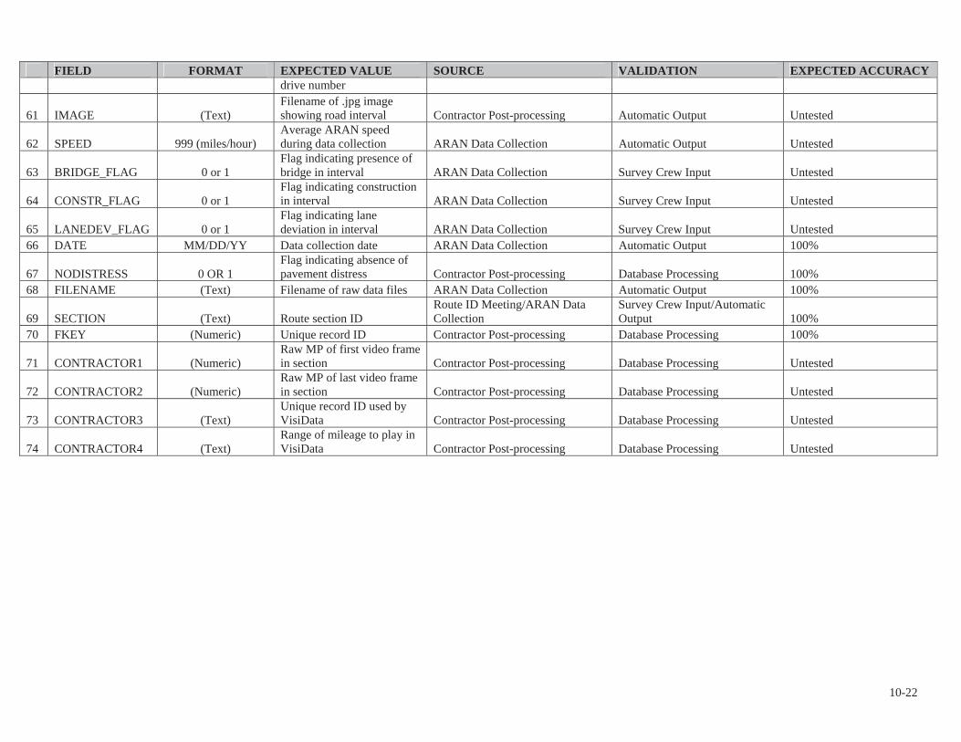
FIELD FORMAT EXPECTED VALUE SOURCE VALIDATION EXPECTED ACCURACYdrive number
61 IMAGE (Text)Filename of .jpg image showing road interval Contractor Post-processing Automatic Output Untested
62 SPEED 999 (miles/hour)Average ARAN speed during data collection ARAN Data Collection Automatic Output Untested
63 BRIDGE_FLAG 0 or 1Flag indicating presence of bridge in interval ARAN Data Collection Survey Crew Input Untested
64 CONSTR_FLAG 0 or 1Flag indicating construction in interval ARAN Data Collection Survey Crew Input Untested
65 LANEDEV_FLAG 0 or 1Flag indicating lane deviation in interval ARAN Data Collection Survey Crew Input Untested
66 DATE MM/DD/YY Data collection date ARAN Data Collection Automatic Output 100%
67 NODISTRESS 0 OR 1Flag indicating absence of pavement distress Contractor Post-processing Database Processing 100%
68 FILENAME (Text) Filename of raw data files ARAN Data Collection Automatic Output 100%
69 SECTION (Text) Route section ID Route ID Meeting/ARAN Data Collection
Survey Crew Input/Automatic Output 100%
70 FKEY (Numeric) Unique record ID Contractor Post-processing Database Processing 100%
71 CONTRACTOR1 (Numeric)Raw MP of first video frame in section Contractor Post-processing Database Processing Untested
72 CONTRACTOR2 (Numeric)Raw MP of last video frame in section Contractor Post-processing Database Processing Untested
73 CONTRACTOR3 (Text)Unique record ID used by VisiData Contractor Post-processing Database Processing Untested
74 CONTRACTOR4 (Text)Range of mileage to play in VisiData Contractor Post-processing Database Processing Untested
10-22

ROUTE_GPS table metadata: FIELD FORMAT EXPECTED VALUE SOURCE VALIDATION EXPECTED ACCURACY
1 RIP_CYCLE XX 4, for RIP data collection Cycle 4 Route ID Meeting FHWA Determination 100% referenced to other tables
2 STATE XX State where route is located Route ID Meeting Park Input/FHWA Determination Untested
3 PARK_ALPHA XXXX Park alpha code Route ID Meeting NPS References 100% Referenced to other tables
4 PARK_NO XXXX Park numeric code Route ID Meeting NPS References 100% Referenced to other tables
5 RTE_NO 9999XXX Route number Route ID Meeting Park Input/FHWA Classification
100% Referenced to other tables
6 FUNCT_CLASS X Route functional classification Route ID Meeting Park Input/FHWA Classification
100% Referenced to other tables
7 RTE_NAME (Text) Route name Route ID Meeting Park Input
100% Referenced to other tables . 100 characters fit in field
8 LANE_NUMBER 99 Data collection lane Contractor Post-processing Database Processing Untested
9 DIRECTION XXXSurvey lane: PRI (primary) or OPP (opposite) Route ID Meeting
Park Input/FHWA Determination Untested
10 MP 999.999 Mile Post (at 0.01 record) ARAN Data Collection, Contractor Post-processing
Survey Crew Input/GPS Processing Untested (3)
11 GPS_LAT 999.999999GPS Latitude Co-ordinate (decimal degrees)
ARAN Data Collection, Contractor Post-processing Automatic Output <= 3.00 feet
12 GPS_LON -999.999999GPS Longitude Co-ordinate (-decimal degrees)
ARAN Data Collection, Contractor Post-processing Automatic Output <= 3.00 feet
13 GPS_ELEV 99999.9 ElevationARAN Data Collection, Contractor Post-processing Automatic Output Untested
14 GPS_MODE XXXGPS Satellite Mode during collection
ARAN Data Collection, Contractor Post-processing Automatic Output Untested
15 XFALL 999.9
Cross Fall: % Slope at GPS Location (Caution, Data not Validated)
ARAN Data Collection, Contractor Post-processing Automatic Output Untested
16 GRADE 999.9 Grade: % Slope at GPS Location (Caution, Data not Validated)
ARAN Data Collection, Contractor Post-processing Automatic Output Untested
17 HEADING 999.9 Heading Relative to True North ARAN Data Collection Automatic Output Untested 18 DATUM (Text) LL_WGS84_DD ARAN Data Collection Database Processing Untested19 FILENAME (Text) Filename of raw data files ARAN Data Collection Automatic Output Untested 20 FKEY 9999999 Unique record ID Contractor Post-processing Database Processing Untested
10-23
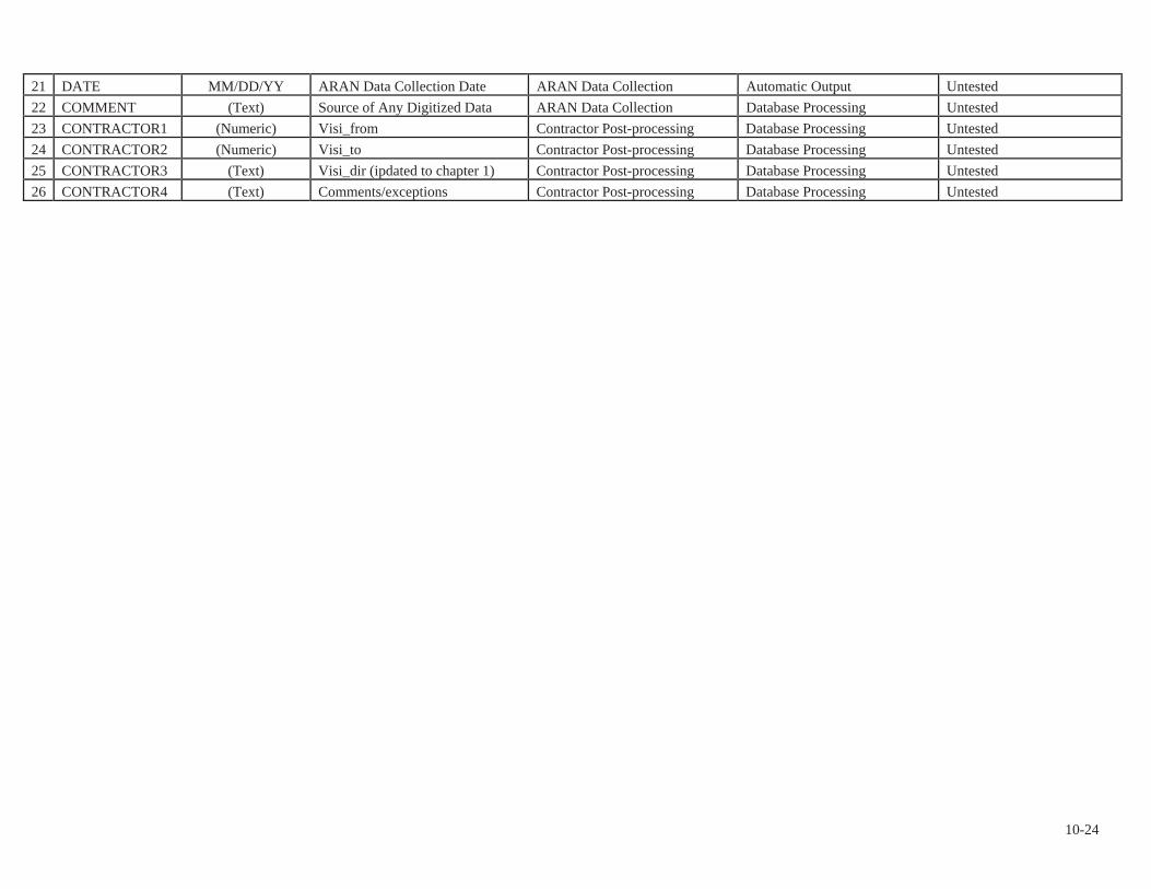
21 DATE MM/DD/YY ARAN Data Collection Date ARAN Data Collection Automatic Output Untested 22 COMMENT (Text) Source of Any Digitized Data ARAN Data Collection Database Processing Untested 23 CONTRACTOR1 (Numeric) Visi_from Contractor Post-processing Database Processing Untested 24 CONTRACTOR2 (Numeric) Visi_to Contractor Post-processing Database Processing Untested 25 CONTRACTOR3 (Text) Visi_dir (ipdated to chapter 1) Contractor Post-processing Database Processing Untested 26 CONTRACTOR4 (Text) Comments/exceptions Contractor Post-processing Database Processing Untested
10-24
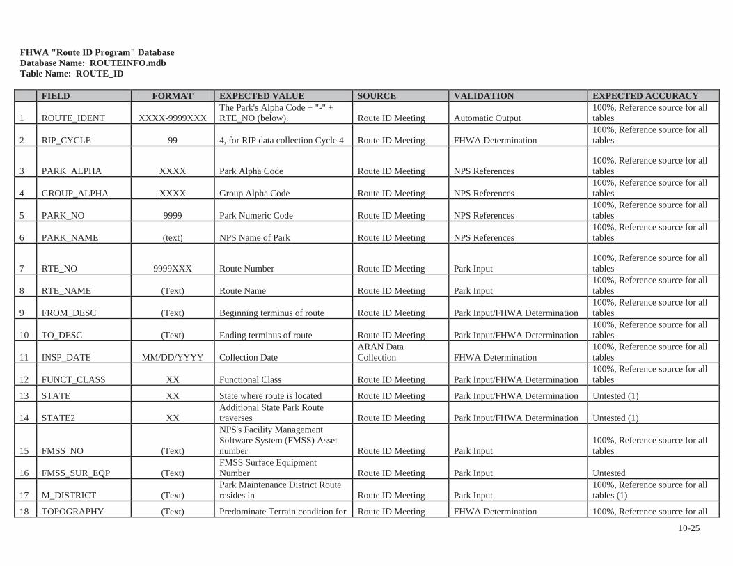
FHWA "Route ID Program" Database Database Name: ROUTEINFO.mdbTable Name: ROUTE_ID
FIELD FORMAT EXPECTED VALUE SOURCE VALIDATION EXPECTED ACCURACY
1 ROUTE_IDENT XXXX-9999XXXThe Park's Alpha Code + "-" + RTE_NO (below). Route ID Meeting Automatic Output
100%, Reference source for all tables
2 RIP_CYCLE 99 4, for RIP data collection Cycle 4 Route ID Meeting FHWA Determination 100%, Reference source for all tables
3 PARK_ALPHA XXXX Park Alpha Code Route ID Meeting NPS References 100%, Reference source for all tables
4 GROUP_ALPHA XXXX Group Alpha Code Route ID Meeting NPS References 100%, Reference source for all tables
5 PARK_NO 9999 Park Numeric Code Route ID Meeting NPS References 100%, Reference source for all tables
6 PARK_NAME (text) NPS Name of Park Route ID Meeting NPS References 100%, Reference source for all tables
7 RTE_NO 9999XXX Route Number Route ID Meeting Park Input 100%, Reference source for all tables
8 RTE_NAME (Text) Route Name Route ID Meeting Park Input 100%, Reference source for all tables
9 FROM_DESC (Text) Beginning terminus of route Route ID Meeting Park Input/FHWA Determination 100%, Reference source for all tables
10 TO_DESC (Text) Ending terminus of route Route ID Meeting Park Input/FHWA Determination 100%, Reference source for all tables
11 INSP_DATE MM/DD/YYYY Collection DateARAN Data Collection FHWA Determination
100%, Reference source for all tables
12 FUNCT_CLASS XX Functional Class Route ID Meeting Park Input/FHWA Determination 100%, Reference source for all tables
13 STATE XX State where route is located Route ID Meeting Park Input/FHWA Determination Untested (1)
14 STATE2 XXAdditional State Park Route traverses Route ID Meeting Park Input/FHWA Determination Untested (1)
15 FMSS_NO (Text)
NPS's Facility Management Software System (FMSS) Asset number Route ID Meeting Park Input
100%, Reference source for all tables
16 FMSS_SUR_EQP (Text)FMSS Surface Equipment Number Route ID Meeting Park Input Untested
17 M_DISTRICT (Text)Park Maintenance District Route resides in Route ID Meeting Park Input
100%, Reference source for all tables (1)
18 TOPOGRAPHY (Text) Predominate Terrain condition for Route ID Meeting FHWA Determination 100%, Reference source for all
10-25

FIELD FORMAT EXPECTED VALUE SOURCE VALIDATION EXPECTED ACCURACYRoute. (FLAT, ROLLING, MOUNTAINOUS, or URBAN)
tables (1)
19 POSTED_SPEED 99
Posted Speed Limit for Route (Value is Predominate Speed Limit along Route) Route ID Meeting Park Input/FHWA Determination Untested (1)
20 ARAN_ROUTE XXX Yes/No Route ID Meeting Park Input/FHWA Determination 100%, Reference source for all tables
21 PARKING_AREA XXX Yes/No Route ID Meeting Park Input/FHWA Determination 100%, Reference source for all tables
22 CONCESSION XXX Yes/No Route ID Meeting Park Input 100%, Reference source for all tables
23 PAVED_MI 999.999Paved mileage (to the nearest 0.001)
ARAN Data Collection Automatic Output
100%, Reference source for all tables
24 UNPAVED_MI 999.999Unpaved mileage (to the nearest 0.001) Route ID Meeting Automatic Output
100%, Reference source for all tables
25 RTE_LENGTH 999.999 Official Route LengthContractor Post-processing Automatic Output
100%, Reference source for all tables
26 SURF_TYPE XX
Surface type (PAVED: AS (asphalt, includes composite), CO (concrete), BR (brick/pavers), CB (cobblestone), OT (other)) Route ID Meeting Survey Crew Input
100%, Reference source for all tables (1)
27 UNPAVED XXXX Unpaved Route (Yes/No/Both) Route ID Meeting Automatic Output 100%, Reference source for all tables
28 UNPAVED_CAT XXX Unpaved Road Category Route ID Meeting Automatic Output Untested
29 CURB (Text)Parking Area with Curb around perimeter. Route ID Meeting Park Input/FHWA Determination Untested
30 CURB_GUTTER (Text)Parking Area with Curb and Gutter around perimeter. Route ID Meeting Park Input/FHWA Determination Untested
31 ADJ_ROUTE 9999XXX Route number Route ID Meeting Automatic Output 100%, Reference source for all tables
32 USER_ACCESS (Text) Access Designation for Parking Route ID Meeting Park Input/FHWA Determination 100%, Reference source for all tables
33 PHOTO_NO (Text) Photo or Image Route ID Meeting Survey Crew Input 100%, Reference source for all tables
34 PLOT_SIZE (Text) Unpaved Parking Area Size Route ID Meeting Automatic Output 100%, Reference source for all tables
35 SQ_FEET 999.999 Route Square Footage Contractor Post-processing Automatic Output
100%, Reference source for all tables
36 M_RATING (Text) Manual Rating Route ID Meeting Automatic Output 100%, Reference source for all tables
10-26
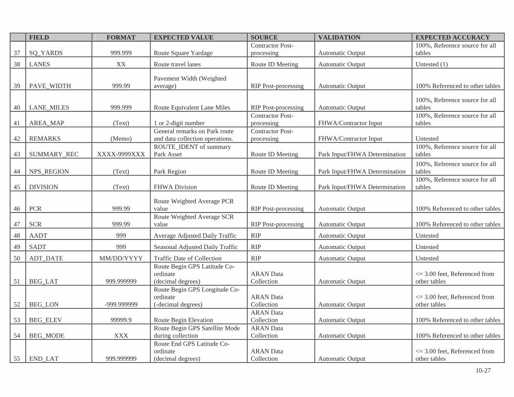
FIELD FORMAT EXPECTED VALUE SOURCE VALIDATION EXPECTED ACCURACY
37 SQ_YARDS 999.999 Route Square Yardage Contractor Post-processing Automatic Output
100%, Reference source for all tables
38 LANES XX Route travel lanes Route ID Meeting Automatic Output Untested (1)
39 PAVE_WIDTH 999.99Pavement Width (Weighted average) RIP Post-processing Automatic Output 100% Referenced to other tables
40 LANE_MILES 999.999 Route Equivalent Lane Miles RIP Post-processing Automatic Output 100%, Reference source for all tables
41 AREA_MAP (Text) 1 or 2-digit number Contractor Post-processing FHWA/Contractor Input
100%, Reference source for all tables
42 REMARKS (Memo)General remarks on Park route and data collection operations.
Contractor Post-processing FHWA/Contractor Input Untested
43 SUMMARY_REC XXXX-9999XXXROUTE_IDENT of summary Park Asset Route ID Meeting Park Input/FHWA Determination
100%, Reference source for all tables
44 NPS_REGION (Text) Park Region Route ID Meeting Park Input/FHWA Determination 100%, Reference source for all tables
45 DIVISION (Text) FHWA Division Route ID Meeting Park Input/FHWA Determination 100%, Reference source for all tables
46 PCR 999.99Route Weighted Average PCR value RIP Post-processing Automatic Output 100% Referenced to other tables
47 SCR 999.99Route Weighted Average SCR value RIP Post-processing Automatic Output 100% Referenced to other tables
48 AADT 999 Average Adjusted Daily Traffic RIP Automatic Output Untested
49 SADT 999 Seasonal Adjusted Daily Traffic RIP Automatic Output Untested
50 ADT_DATE MM/DD/YYYY Traffic Date of Collection RIP Automatic Output Untested
51 BEG_LAT 999.999999
Route Begin GPS Latitude Co-ordinate (decimal degrees)
ARAN Data Collection Automatic Output
<= 3.00 feet, Referenced from other tables
52 BEG_LON -999.999999
Route Begin GPS Longitude Co-ordinate (-decimal degrees)
ARAN Data Collection Automatic Output
<= 3.00 feet, Referenced from other tables
53 BEG_ELEV 99999.9 Route Begin ElevationARAN Data Collection Automatic Output 100% Referenced to other tables
54 BEG_MODE XXXRoute Begin GPS Satellite Mode during collection
ARAN Data Collection Automatic Output 100% Referenced to other tables
55 END_LAT 999.999999
Route End GPS Latitude Co-ordinate (decimal degrees)
ARAN Data Collection Automatic Output
<= 3.00 feet, Referenced from other tables
10-27
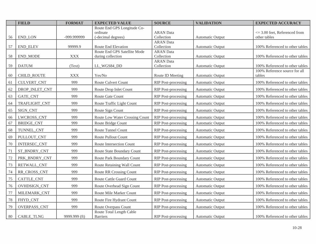
FIELD FORMAT EXPECTED VALUE SOURCE VALIDATION EXPECTED ACCURACY
56 END_LON -999.999999
Route End GPS Longitude Co-ordinate (-decimal degrees)
ARAN Data Collection Automatic Output
<= 3.00 feet, Referenced from other tables
57 END_ELEV 99999.9 Route End Elevation ARAN Data Collection Automatic Output 100% Referenced to other tables
58 END_MODE XXXRoute End GPS Satellite Mode during collection
ARAN Data Collection Automatic Output 100% Referenced to other tables
59 DATUM (Text) LL_WGS84_DDARAN Data Collection Automatic Output 100% Referenced to other tables
60 CHILD_ROUTE XXX Yes/No Route ID Meeting Automatic Output 100% Reference source for all tables
61 CULVERT_CNT 999 Route Culvert Count RIP Post-processing Automatic Output 100% Referenced to other tables
62 DROP_INLET_CNT 999 Route Drop Inlet Count RIP Post-processing Automatic Output 100% Referenced to other tables
63 GATE_CNT 999 Route Gate Count RIP Post-processing Automatic Output 100% Referenced to other tables
64 TRAFLIGHT_CNT 999 Route Traffic Light Count RIP Post-processing Automatic Output 100% Referenced to other tables
65 SIGN_CNT 999 Route Sign Count RIP Post-processing Automatic Output 100% Referenced to other tables
66 LWCROSS_CNT 999 Route Low Water Crossing Count RIP Post-processing Automatic Output 100% Referenced to other tables 67 BRIDGE_CNT 999 Route Bridge Count RIP Post-processing Automatic Output 100% Referenced to other tables
68 TUNNEL_CNT 999 Route Tunnel Count RIP Post-processing Automatic Output 100% Referenced to other tables
69 PULLOUT_CNT 999 Route Pullout Count RIP Post-processing Automatic Output 100% Referenced to other tables
70 INTERSEC_CNT 999 Route Intersection Count RIP Post-processing Automatic Output 100% Referenced to other tables
71 ST_BNDRY_CNT 999 Route State Boundary Count RIP Post-processing Automatic Output 100% Referenced to other tables
72 PRK_BNDRY_CNT 999 Route Park Boundary Count RIP Post-processing Automatic Output 100% Referenced to other tables
73 RETWALL_CNT 999 Route Retaining Wall Count RIP Post-processing Automatic Output 100% Referenced to other tables
74 RR_CROSS_CNT 999 Route RR Crossing Count RIP Post-processing Automatic Output 100% Referenced to other tables
75 CATTLE_CNT 999 Route Cattle Guard Count RIP Post-processing Automatic Output 100% Referenced to other tables
76 OVHDSIGN_CNT 999 Route Overhead Sign Count RIP Post-processing Automatic Output 100% Referenced to other tables
77 MILEMARK_CNT 999 Route Mile Marker Count RIP Post-processing Automatic Output 100% Referenced to other tables
78 FHYD_CNT 999 Route Fire Hydrant Count RIP Post-processing Automatic Output 100% Referenced to other tables
79 OVERPASS_CNT 999 Route Overpass Count RIP Post-processing Automatic Output 100% Referenced to other tables
80 CABLE_TLNG 9999.999 (ft)Route Total Length Cable Barriers RIP Post-processing Automatic Output 100% Referenced to other tables
10-28
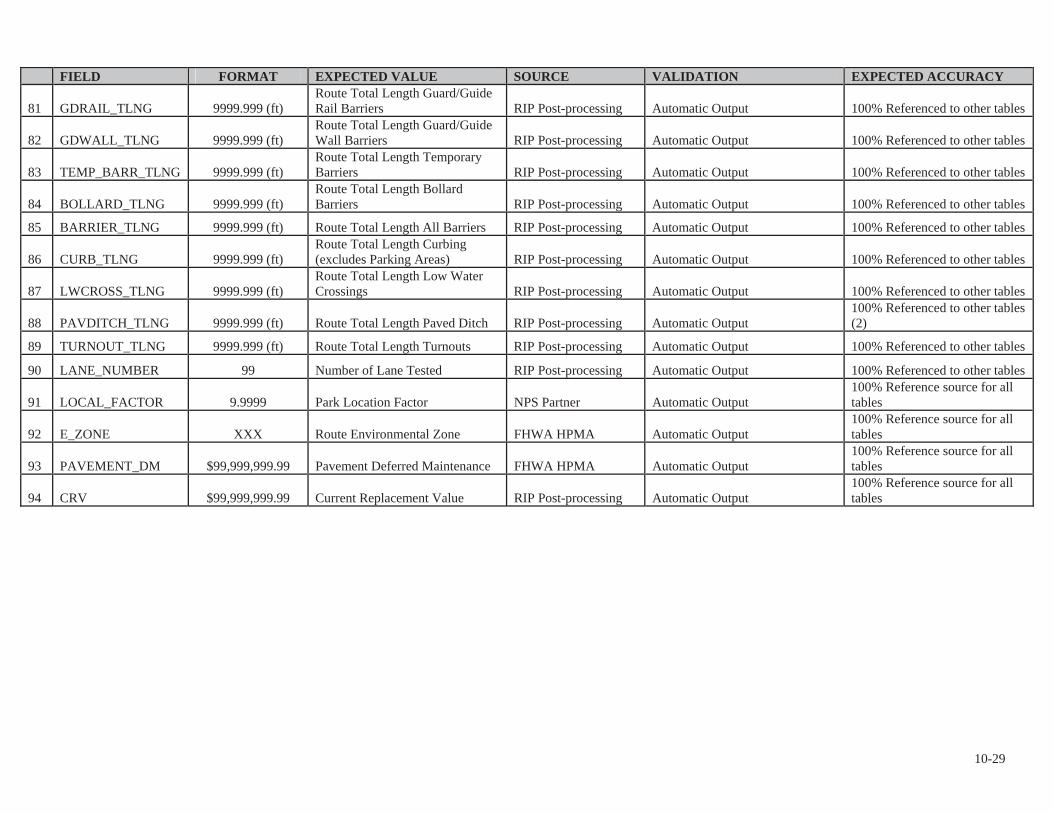
FIELD FORMAT EXPECTED VALUE SOURCE VALIDATION EXPECTED ACCURACY
81 GDRAIL_TLNG 9999.999 (ft)Route Total Length Guard/Guide Rail Barriers RIP Post-processing Automatic Output 100% Referenced to other tables
82 GDWALL_TLNG 9999.999 (ft)Route Total Length Guard/Guide Wall Barriers RIP Post-processing Automatic Output 100% Referenced to other tables
83 TEMP_BARR_TLNG 9999.999 (ft)Route Total Length Temporary Barriers RIP Post-processing Automatic Output 100% Referenced to other tables
84 BOLLARD_TLNG 9999.999 (ft)Route Total Length Bollard Barriers RIP Post-processing Automatic Output 100% Referenced to other tables
85 BARRIER_TLNG 9999.999 (ft) Route Total Length All Barriers RIP Post-processing Automatic Output 100% Referenced to other tables
86 CURB_TLNG 9999.999 (ft)Route Total Length Curbing (excludes Parking Areas) RIP Post-processing Automatic Output 100% Referenced to other tables
87 LWCROSS_TLNG 9999.999 (ft)Route Total Length Low Water Crossings RIP Post-processing Automatic Output 100% Referenced to other tables
88 PAVDITCH_TLNG 9999.999 (ft) Route Total Length Paved Ditch RIP Post-processing Automatic Output 100% Referenced to other tables (2)
89 TURNOUT_TLNG 9999.999 (ft) Route Total Length Turnouts RIP Post-processing Automatic Output 100% Referenced to other tables
90 LANE_NUMBER 99 Number of Lane Tested RIP Post-processing Automatic Output 100% Referenced to other tables
91 LOCAL_FACTOR 9.9999 Park Location Factor NPS Partner Automatic Output 100% Reference source for all tables
92 E_ZONE XXX Route Environmental Zone FHWA HPMA Automatic Output 100% Reference source for all tables
93 PAVEMENT_DM $99,999,999.99 Pavement Deferred Maintenance FHWA HPMA Automatic Output 100% Reference source for all tables
94 CRV $99,999,999.99 Current Replacement Value RIP Post-processing Automatic Output 100% Reference source for all tables
10-29

Database Name: ROUTEINFO.mdbTable Name: PARK_TOTALS
FIELD FORMAT EXPECTED VALUE SOURCE VALIDATIONEXPECTEDACCURACY
1 RIP_CYCLE 99 4, for RIP data collection Cycle 4 Route ID Meeting FHWA Determination 100% Referenced to other tables
2 PARK_ALPHA XXXX Park Alpha Code Route ID Meeting FHWA Determination 100% Referenced to other tables
3 GROUP_ALPHA XXXX Group Alpha Code Route ID Meeting NPS References 100% Referenced to other tables
4 PARK_NO 9999 Park Numeric Code Route ID Meeting NPS References 100% Referenced to other tables
5 PARK_NAME XXXX NPS Name of Park Route ID Meeting NPS References 100% Referenced to other tables
6 INSP_DATE MM/DD/YYYYDate that data was collected in the park (completion date).
Route ID Meeting and ARAN Data Collection FHWA Determination
100% Referenced to other tables
7 NPS_REGION XXXX Park Region Route ID Meeting Park Input 100% Referenced to other tables
8 DIVISION XXXX FHWA Division Route ID Meeting FHWA Determination 100% Referenced to other tables
9 T_PAVED_MI 999.999 Total Park Paved Miles RIP Post-processing Automatic Output 100% Referenced to other tables
10 T_UNPAVED_MI 999.999 Total Park Unpaved Miles RIP Post-processing Automatic Output 100% Referenced to other tables
11 T_ROUTE_MILES 999.999 Total Park Route Miles RIP Post-processing Automatic Output 100% Referenced to other tables
12 T_ARAN_DRIVEN 999.999 Total Park ARAN Driven Miles RIP Post-processing Automatic Output 100% Referenced to other tables
13 T_ARAN_LMILES 999.999 Total Park ARAN Lane Miles RIP Post-processing Automatic Output 100% Referenced to other tables
14 T_CONCESS_PAVED 999.999 Total Park Concession Paved Miles RIP Post-processing Automatic Output 100% Referenced to other tables
15 T_CONCESS_UNPAVED 999.999 Total Park Concession Unpaved Miles RIP Post-processing Automatic Output 100% Referenced to other tables
16 T_PRK_PAVEDSQFT 999.999 Total Park Parking Paved Square Feet RIP Post-processing Automatic Output 100% Referenced to other tables
17 T_PRK_UNPAVEDSQFT 999.999Total Park Parking Unpaved Square Feet RIP Post-processing Automatic Output
100% Referenced to other tables
18 T_CPRK_PAVEDSQFT 999.999Total Park Concession Parking Paved Square Feet RIP Post-processing Automatic Output
100% Referenced to other tables
10-30

10-31
FIELD FORMAT EXPECTED VALUE SOURCE VALIDATION EXPECTED ACCURACY
19 T_CPRK_UNPAVEDSQFT 999.999Total Park Concession Parking Unpaved Square Feet RIP Post-processing Automatic Output
100% Referenced to other tables
20 T_PARKING_SQFT 999.999 Total Park Parking Square Feet RIP Post-processing Automatic Output 100% Referenced to other tables
21 T_PARKING_LMILES 999.999Total Park Parking Equivalent Lane Miles RIP Post-processing Automatic Output
100% Referenced to other tables
22 T_MRR_SQFT 999.999Total Park Manually Rated Road Square Feet RIP Post-processing Automatic Output
100% Referenced to other tables
23 T_CMRR_SQFT 999.999Total Park Concession Manually Rated Road Square Feet RIP Post-processing Automatic Output
100% Referenced to other tables
24 T_MRR_LMILES 999.999Total Park Manually Rated Road Equivalent Lane Miles RIP Post-processing Automatic Output
100% Referenced to other tables
25 T_LMILES 999.999 Total Park Lane Miles RIP Post-processing Automatic Output 100% Referenced to other tables
26 T_CULVERT_CNT 999 Total Park Culvert Count RIP Post-processing Automatic Output 100% Referenced to other tables
27 T_DROP_INLET_CNT 999 Total Park Drop Inlet Count RIP Post-processing Automatic Output 100% Referenced to other tables
28 T_GATE_CNT 999 Total Park Gate Count RIP Post-processing Automatic Output 100% Referenced to other tables
29 T_TRAFLIGHT_CNT 999 Total Park Traffic light Count RIP Post-processing Automatic Output 100% Referenced to other tables
30 T_SIGN_CNT 999 Total Park Sign Count RIP Post-processing Automatic Output 100% Referenced to other tables
31 T_LWCROSS_CNT 999 Total Park Low Water Count RIP Post-processing Automatic Output 100% Referenced to other tables
32 T_BRIDGE_CNT 999 Total Park Bridge Count RIP Post-processing Automatic Output 100% Referenced to other tables
33 T_TUNNEL_CNT 999 Total Park Tunnel Count RIP Post-processing Automatic Output 100% Referenced to other tables
34 T_PULLOUT_CNT 999 Total Park Pullout Count RIP Post-processing Automatic Output 100% Referenced to other tables
35 T_INTERSEC_CNT 999 Total Park Intersections Count RIP Post-processing Automatic Output 100% Referenced to other tables
36 T_ST_BNDRY_CNT 999 Total Park State Boundaries Count RIP Post-processing Automatic Output 100% Referenced to other tables
37 T_PRK_BNDRY_CNT 999 Total Park Boundaries Count RIP Post-processing Automatic Output 100% Referenced to other tables
38 T_RETWALL_CNT 999 Total Park Retaining Wall Count RIP Post-processing Automatic Output 100% Referenced to other tables
39 T_RR_CROSS_CNT 999 Total Park RR Crossing Count RIP Post-processing Automatic Output 100% Referenced to other

FIELD FORMAT EXPECTED VALUE SOURCE VALIDATIONEXPECTEDACCURACYtables
40 T_CATTLE_CNT 999 Total Park Cattle Guard Count RIP Post-processing Automatic Output 100% Referenced to other tables
41 T_OVHDSIGN_CNT 999 Total Park Overhead Sign Count RIP Post-processing Automatic Output 100% Referenced to other tables
42 T_MILEMARK_CNT 999 Total Park Mile Marker Count RIP Post-processing Automatic Output 100% Referenced to other tables
43 T_FHYD_CNT 999 Total Park Fire Hydrant Count RIP Post-processing Automatic Output 100% Referenced to other tables
44 T_OVERPASS_CNT 999 Total Park Overpass Count RIP Post-processing Automatic Output 100% Referenced to other tables
45 T_CABLE_TLNG 9999.999 (ft) Total Length Park Cable Barriers RIP Post-processing Automatic Output 100% Referenced to other tables
46 T_GDRAIL_TLNG 9999.999 (ft)Total Length Park Guard/Guide Rail Barriers RIP Post-processing Automatic Output
100% Referenced to other tables
47 T_GDWALL_TLNG 9999.999 (ft)Total Length Park Guard/Guide Wall Barriers RIP Post-processing Automatic Output
100% Referenced to other tables
48 T_TEMP_BARR_TLNG 9999.999 (ft) Total Length Park Temporary Barriers RIP Post-processing Automatic Output 100% Referenced to other tables
49 T_BOLLARD_TLNG 9999.999 (ft) Total Length Park Bollard Barriers RIP Post-processing Automatic Output 100% Referenced to other tables
50 T_BARRIER_TLNG 9999.999 (ft) Total Length All Park Barriers RIP Post-processing Automatic Output 100% Referenced to other tables
51 T_CURB_TLNG 9999.999 (ft) Total Length Park Curbing RIP Post-processing Automatic Output 100% Referenced to other tables
52 T_LWCROSS_TLNG 9999.999 (ft) Total Length Park Low Water Crossings RIP Post-processing Automatic Output 100% Referenced to other tables
53 T_PAVDITCH_TLNG 9999.999 (ft) Total Length Park Paved Ditches RIP Post-processing Automatic Output 100% Referenced to other tables (2)
54 T_TURNOUT_TLNG 9999.999 (ft) Total Length Park Turnouts RIP Post-processing Automatic Output 100% Referenced to other tables
55 PARK_PCR 99.99 Overall Park PCR Rating RIP Post-processing Automatic Output 100% Referenced to other tables
56 PARK_RCI 99.99 Overall Park RCI Rating RIP Post-processing Automatic Output 100% Referenced to other tables
57 PARK_SCR 99.99 Overall Park SCR Rating RIP Post-processing Automatic Output 100% Referenced to other tables
58 PARK_RUT_INDEX 99.99 Overall Park Rutting Index Rating RIP Post-processing Automatic Output 100% Referenced to other tables
59 PARK_AC_INDEX 99.99Overall Park Alligator Cracking Index Rating RIP Post-processing Automatic Output
100% Referenced to other tables
10-32
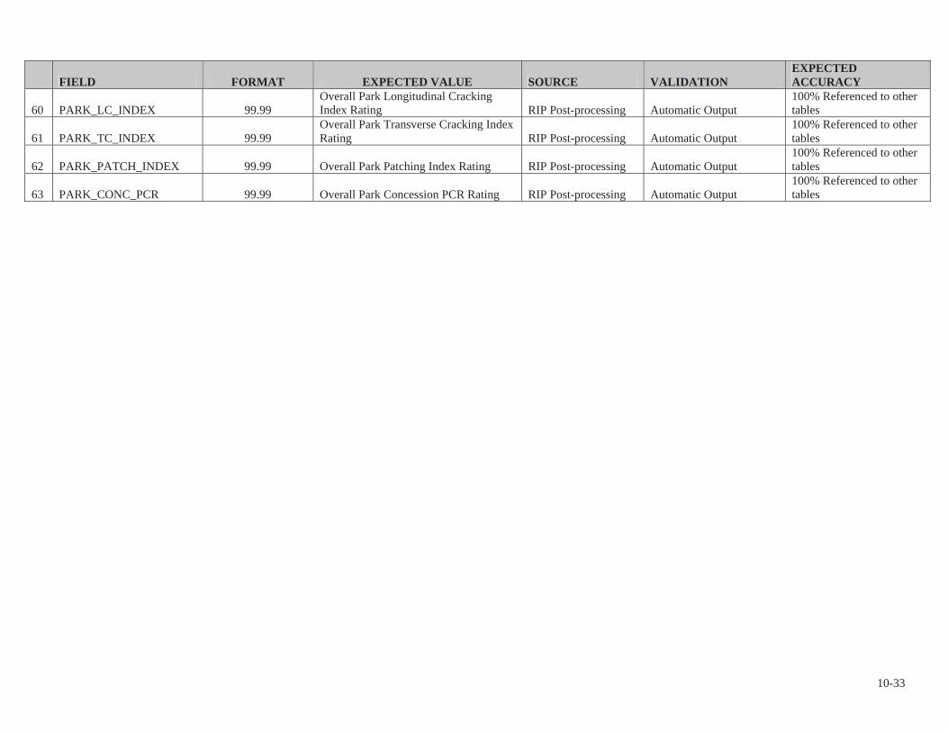
FIELD FORMAT EXPECTED VALUE SOURCE VALIDATIONEXPECTEDACCURACY
60 PARK_LC_INDEX 99.99Overall Park Longitudinal Cracking Index Rating RIP Post-processing Automatic Output
100% Referenced to other tables
61 PARK_TC_INDEX 99.99Overall Park Transverse Cracking Index Rating RIP Post-processing Automatic Output
100% Referenced to other tables
62 PARK_PATCH_INDEX 99.99 Overall Park Patching Index Rating RIP Post-processing Automatic Output 100% Referenced to other tables
63 PARK_CONC_PCR 99.99 Overall Park Concession PCR Rating RIP Post-processing Automatic Output 100% Referenced to other tables
10-33

10 - 34
Business Practices for Route Numbering and Roadway Asset Identification
Introduction and Background: Beginning in November 2006, inventory and condition information gathered by the Federal Highway Administration (FHWA) has been stored in FMSS to enable NPS to report Deferred Maintenance (DM) and Current Replacement Value (CRV) for NPS paved roads, paved parking areas, bridges, and tunnels. The NPS Roads Working Group (RWG) has been tasked with developing and implementing the procedures necessary to transfer DM and CRV from FHWA’s databases to NPS’ Facility Management Software System (FMSS).
Current business practices for roadway definition in national parks involve face-to-face meetings between FHWA personnel and individual park staff known as “Route ID” meetings. These meetings have been ongoing for several years and have been performed within the context of the Road Inventory Program (RIP) executed mainly by FHWA. The primary focus of these meetings has been on defining roadway static information such as route names, numbers, functional class, etc. The FHWA personnel are the primary individuals responsible for implementing the RIP and the route ID meetings are an integral and fundamental part of that process. The RIP process provides route numbers for each individual road and parking area in each park. After the route ID meetings establish a given park’s roadway asset base, various types of condition and inventory data are collected either manually or with a data collection van that drives each individual road with an individual route number.
The FMSS requires asset numbers as unique identifiers for all asset types including roadways. The current practice is that all roadways that are assigned a route number at route ID, also are defined as assets and therefore also receive an FMSS asset number (Route names and functional classes are also collaboratively assigned during the face-to-face route ID meetings). This practice began midway through the third RIP data collection cycle (ending in 2003) and was further reinforced during an asset alignment process conducted in the summer of 2006. The alignment process ensured that each route number in RIP and each asset number in FMSS were matched to the correct road and parking area.
Issue Statement: As a result of various pre-existing business practices associated with the RIP, which predates FMSS by several years, route numbers are assigned for routes that are often very small. In tandem with the current business practice that all routes with route numbers are considered assets, this has caused a proliferation of asset numbers within FMSS. Over the past year, the RWG has learned that this business practice has significantly increased time and resources that parks must dedicate to administering FMSS data entry and management. This additional work effort is due to the fact that tying FMSS asset records to the more detailed, granular RIP route numbers has generated numerous new assets that require additional database and work order management. This has led to a situation where assets are not being defined the way they are managed.

10 - 35
The following proposed practices seek to create an asset definition process that is dictated by to how road assets are managed at the park level, not according to the pre-existing practices used in RIP for collecting detailed road information. RIP practices assign route numbers mainly based on how data are collected and driven with a data collection device.These procedures will disassociate the driving of roads with the data collection van from the process of assigning them asset status. The end goal is to only assign asset numbers based on how parks manage their facilities within guidelines set up within FMSS and herein. Driving the road with the data collection van allows for the collection of higher quality data as well as the ability to view road segments with video viewing software (Visidata). By de-linking driving the roads with the assignment of “asset status”, we are able to get the best quality data without the proliferation of assets that has serious negative ramifications for managing roadways in parks using asset management tools.
Proposed Actions: 1. Make a distinction within the route number field in the RIP database between
those route numbers that represent assets, those that are subcomponents of assets and those that are groups of sub-components. The route number field in the RIP database will be expanded from 6 to 7 characters. The additional character will denote the asset status of the route in question. Combined routes will be designated with a double “zz”, while subcomponents will be designated with one “z”. Whenever possible, a combined route should use the lowest route number to be combined as the combined route number.
2. Only show assets, whether a group of subcomponents or a single component, on the Route ID report. Assets that are composed of subcomponents will have “zz” in the route number. Individual routes will have no additional characters in the route number. Subcomponents (designated in RIP with a “z”) will not be listed on the route ID report. Only assign asset numbers to those routes listed on the route ID report.
3. Provide a separate reporting function (other than the Route ID report) to identify and display information for route numbers not representing assets. Specific reporting requirements and format TBD.
4. Add a new field to the RIP database to indicate the “asset status” of a route number. The flag will have three possible values:
a. Asset with no subcomponents. b. Asset with subcomponents. c. Non-asset (i.e. subcomponent).
Both a change in the route number and a new “asset ID” field in the RIP database are recommended. It is easier to perform queries and other database manipulations using a separate field instead of a character within the route number field. The character in the route number field allows for rapid identification of the asset status of a road without having to access the database as a whole. Even thought non-asset routes will not be included in the route ID report (the primary location for parks to view road information in RIP), there are many other reports as well as the Visidata application where the route number is
10 - 36
displayed. In these cases, the character in the route number will clearly identify the asset status of the roadway.
5. Focus asset definition practices on NPS asset management needs. Create roadway assets based on how parks manage these assets within the following guidelines:
a. Individual road segments (asset subcomponents) may be combined into a single asset. Note that all the attributes of individual subcomponents (paved area, equipment, work orders, etc) will be included in the combined asset.
b. In general, combination should be used in complex circulatory environments such as campground areas, housing and other administrative areas, maintenance areas, etc.
c. Public and non-public segments may not be combined. d. Segments with differing functional classes may not be combined. e. Discrete parking areas may be combined into a single asset where they
service the same facility or resource and are within walking distance of each other.
f. Parking areas and roads may not be combined. This includes short road segments that may be near or adjacent to parking areas. See 5h below for exceptions to this.
g. Where the primary purpose of a road is to provide access to a parking area, and that road segment is approximately 0.25 miles in length or shorter, the access road should be considered part of the parking area (Note that this is an existing RIP business practice).
h. Particularly long routes may be divided into multiple assets based on how a park manages the roadway network. This should not be confused with the use of sub-components listed in 5a.
i. Roads that are actively managed by concession operations may not be combined with those managed by the NPS.
Discussion:The first four items listed above are actions required by FHWA RIP to allow for the adoption of the practices shown in 5a-i. The following will provide additional direction and examples for guidelines listed.
Individual road segments (asset subcomponents) may be combined into a single asset.Where previous route ID practices have generated more assets (routes) than are practical from an asset management standpoint, small, discrete road lengths may be designated as asset subcomponents and then combined into a larger single asset. A subcomponent is NOT an FMSS term. Subcomponents will be used in RIP to indicate which routes are small, drivable individual road segments and which routes may include these segments. Once a piece of road is designated a subcomponent of another route, it will no longer have any individual identity in FMSS. Only those routes listed on the RIP Route ID report will have asset numbers in FMSS. As stated in business rule 2 above, subcomponents will not be listed on the route ID. The quantity information (length, area) will be included into the larger route of which they are a part. See Figures 1 and 2 for an example of how existing assets may be combined using subcomponents. Note that

10 - 37
subcomponents will have an identity in the RIP database and, if driven by RIP team, may be referenced in RIP reports, Visidata, or other RIP documentation.
Figure 1: Campground with five routes and five assets
Figure 2: Campground with all loops combined into one route and one asset. This has eliminated four assets.
In general, combination should occur in complex circulatory environments such as campground areas, housing and other administrative areas, maintenance areas, etc.
00204zz
10 - 38
Typically these complex situations are where too many assets have been used to define roadways. Combining simple “point A to point B” roads that are clearly defined and provide access to different facilities or locations may not be done.
Public and non-public segments may not be combined. Roads that are posted as closed to the public or are intended as administrative access only (maintenance areas, housing areas, fire roads, etc) can not be combined with roads open to the public.
Segments with differing functional classes may not be combined. The roadway functional class is found on the Route ID report. Functional class indicates the type of circulatory function a given road provides. Functional class is used in a variety of applications (engineering, safety, funding) so it is important to maintain the correct functional class attributes of individual roads/assets. There are some cases where functional class was erroneously assigned in prior Route ID meetings such as where campground loops have a different functional class than the campground road. Functional classes of individual roads may be modified to correct discrepancies. The functional class definitions may not be modified.
Discrete parking areas may be combined into a single asset where they service the same facility or resource and are within walking distance of each other. These combined areas should be maintained as one asset. There are many instances where small (5-10 space), discrete parking areas have been separated into individual assets even though they provide parking for the same area or facility. These may be combined into a single asset. Figures 3 and 4 shows examples of combining parking areas.

10 - 39
Figure 3: Parking with access route 204 and multiple parking areas (1160 A-L). Currently, this parking area is 12 routes and 12 assets ( one 1100 asset and 11 1300 assets).
Figure 4: Parking with access route 204 and one parking area 1160zz. Route 204 is assumed longer than 0.25 miles. There are now 2 assets (one 1100 asset, one 1300 asset) instead of 12.

10 - 40
Parking areas and roads may not be combined. Parking areas and roads are tracked as separate asset types (1300 vs. 1100) in FMSS and as such should not be combined except in situations described by 5g. In Figure 5, Route 207 is a spur road from the main route running through parking area 1102. Since the spur road continues through and beyond the parking area, it will remain a separate route.
Figure 5: Parking with access route 207 running through and continuing beyond parking 1102. This access route cannot be considered a part of the parking area and two routes and two assets continue to exist.
Where the primary purpose of a road is to provide access to a parking area, and that road segment is less than 0.25 miles in length, the access road should be considered part of the parking area. See Figures 8. Where a road continues on past a parking area to another facility or destination, even if it is less than 0.25 miles to the initial parking area, the road and parking area may not be combined.

10 - 41
Figure 6: Since the access route is less than .25 miles in length and the only use of the access is to the parking, one route for both the access and the parking area can be established.
Particularly long routes may be divided into multiple assets based on how a park manages the roadway network. This should not be confused with the use of sub-components listed in 5a. Routes like the Blue Ridge Parkway or the Yellowstone Grand Loop may not lend themselves to management as a single asset by virtue of their length. Often management districts are created for sections of these routes and maintenance activities occur primarily within these districts. Parks may break routes up into separate assets during the Route ID process if the road is managed as discrete sections. This should only be done for very long roads.
The following example illustrates a complex road system and how the proposed business practice and several of the guidelines could be applied to create fewer assets that are consistent with local management.
6B
6A
Rte 206 less than 0.25 miles

10 - 42
Figure 7 – Current Housing area access configuration. Route 409 is less than 0.25 miles long.
The area serviced by Routes 409, 421, 422, 968A, and 968B is all employee housing. Route 940 provides access to visitor services and not to the housing area. Routes may be combined to create assets that reflect local management. Routes 409, 421, and 422 are all the same functional class, provide access to one type of activity (housing) and are all posted as non-public. These routes may be combined. They should not be combined with any parking areas even though they are all less than 0.25 miles long. This is because their main function is not to provide access to parking. Routes 968A and B provide parking for access to the same facility (housing). Even though these discrete areas may provide parking to different housing units, it’s reasonable to manage them as a single asset. They may also be combined.
Figure 8 – Combined housing area access configuration – Parking and road assets combined to eliminate 3 assets.