Embed Size (px)
Citation preview
REPORT
Cultural Heritage Evaluation Report Commissioners Road West Realignment, Byron Quarry, London, Ontario
Submitted to:
CIMA+ Mr. Stephen Keen, M.Sc., P.Eng. Director of Transportation Planning, CIMA+ 3027 Harvester Road, Suite 400 Burlington, Ontario L7N 3G7
Submitted by:
Golder Associates Ltd. 683 Innovation Drive, Unit 1 Kingston, Ontario, K7K 7E6 Canada
+1 613 542 0029
1531015-5000-R03
September 10, 2018
September 10, 2018 1531015-5000-R03
i
Distribution List 1 e-copy: CIMA+
1 e-copy: Golder Associates Ltd.
September 10, 2018 1531015-5000-R03
ii
Executive Summary
The Executive Summary summarizes only the key points of the report. For a complete account of the results and conclusions, as well as the limitations of this study, the reader should examine the report in full.
In February 2018, CIMA+ retained Golder Associates Ltd. (Golder) to conduct a Cultural Heritage Evaluation Report (CHER) on the Byron Quarry as part of the environmental assessment for the proposed realignment of Commissioners Road West in the City of London, Ontario. Golder’s Heritage Impact Assessment (HIA) for the proposed realignment identified views over the quarry as a potential cultural heritage landscape.
Following guidance from the Ministry of Tourism, Culture and Sport’s (MTCS) Ontario Heritage Tool Kit: Heritage Property Evaluation (2006) and Ontario Regulation 9/06 (O. Reg. 9/06), and the City of London’s Guidelines for the Identification of Cultural Heritage Landscapes (2003), this report identifies the heritage policy context applicable to the Quarry and summarizes the geography and history of the area. It describes the Quarry, evaluates the property for cultural heritage value or interest and provides recommendations for additional cultural heritage studies if necessary.
This CHER concludes that:
The Byron Quarry does not have cultural heritage value or interest; and,
No additional cultural heritage studies are required.

September 10, 2018 1531015-5000-R03
iii
Study Limitations
Golder Associates Ltd. has prepared this report in a manner consistent with guidance developed by the Ontario Ministry of Tourism, Culture and Sport, Culture Division, Programs and Services Branch, Heritage Program Unit, subject to the time limits and physical constraints applicable to this report. No other warranty, expressed or implied is made.
This report has been prepared for the specific site, design objective, developments and purpose described to Golder Associates Ltd., by CIMA+ (the Client). The factual data, interpretations and recommendations pertain to a specific project as described in this report and are not applicable to any other project or site location.
The information, recommendations and opinions expressed in this report are for the sole benefit of the Client. No other party may use or rely on this report or any portion thereof without Golder Associates Ltd.’s express written consent. If the report was prepared to be included for a specific permit application process, then upon the reasonable request of the Client, Golder Associates Ltd. may authorize in writing the use of this report by the regulatory agency as an Approved User for the specific and identified purpose of the applicable permit review process. Any other use of this report by others is prohibited and is without responsibility to Golder Associates Ltd. The report, all plans, data, drawings and other documents as well as electronic media prepared by Golder Associates Ltd. are considered its professional work product and shall remain the copyright property of Golder Associates Ltd., who authorizes only the Client and Approved Users to make copies of the report, but only in such quantities as are reasonably necessary for the use of the report by those parties. The Client and Approved Users may not give, lend, sell, or otherwise make available the report or any portion thereof to any other party without the express written permission of Golder Associates Ltd. The Client acknowledges the electronic media is susceptible to unauthorized modification, deterioration and incompatibility and therefore the Client cannot rely upon the electronic media versions of Golder Associates Ltd.’s report or other work products.
Unless otherwise stated, the suggestions, recommendations and opinions given in this report are intended only for the guidance of the Client in the design of the specific project.
September 10, 2018 1531015-5000-R03
iv
Table of Contents
1.0 INTRODUCTION .............................................................................................................................................. 1
2.0 SCOPE AND METHOD.................................................................................................................................... 3
3.0 PLANNING, LEGAL AND REGULATORY CONTEXT ................................................................................... 4
3.1.1 Environmental Assessment Act and Municipal Class Environmental Assessments ...................... 4
3.1.2 Planning Act and Provincial Policy Statement ................................................................................ 4
3.1.3 Ontario Heritage Act and Ontario Regulation 9/06 ......................................................................... 5
3.1.4 Ministry of Tourism, Culture and Sport Guidance for Cultural Heritage Evaluation ....................... 6
3.2 Municipal Heritage Policies .................................................................................................................. 7
3.2.1 The London Plan ............................................................................................................................. 7
4.0 GEOGRAPHIC & HISTORICAL CONTEXT .................................................................................................... 8
4.1 Geographic Context ............................................................................................................................. 8
4.2 Historical Context ................................................................................................................................. 8
4.2.1 Westminster Township .................................................................................................................... 8
4.2.2 The Byron Quarry............................................................................................................................ 9
5.0 EXISTING CONDITIONS ............................................................................................................................... 16
5.1 Setting ................................................................................................................................................ 16
5.2 Byron Quarry ...................................................................................................................................... 18
6.0 EVALUATION OF CULTURAL HERITAGE VALUE OR INTEREST ........................................................... 22
6.1.1 Design or Physical Value .............................................................................................................. 22
6.1.2 Historical or Associative Value ...................................................................................................... 22
6.1.3 Contextual Value ........................................................................................................................... 23
6.2 Results of Evaluation ......................................................................................................................... 23
7.0 SUMMARY STATEMENT AND RECOMMENDATIONS .............................................................................. 24
8.0 REFERENCES ............................................................................................................................................... 25
September 10, 2018 1531015-5000-R03
v
FIGURES
Figure 1: Location Plan. ............................................................................................................................................ 2
Figure 2: Provincial and municipal policies relevant to the heritage conservation in the Byron Quarry .................. 4
Figure 3: 1820 Burwell Survey Map of Westminster Township (Detail). ................................................................ 10
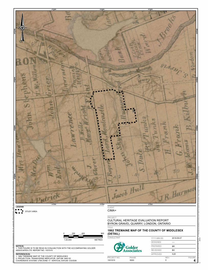
Figure 4: 1862 Tremaine Map of the County of Middlesex (Detail). ....................................................................... 11
Figure 5: 1878 Page Historical Atlas Map of Westminster Township (Detail). ....................................................... 12
Figure 6: 1919 Department of Defense Topographic Map St. Thomas Sheet 40 I/14 Scale 1:63,360 (Detail). .... 13
Figure 7: 1941 Department of Defense Topographic Map ST. Thomas Sheet 40 I/14 Scale 1:63,360 (Detail). .................................................................................................................................................... 14
Figure 8: Air Photos. ............................................................................................................................................... 15
Figure 9: View facing north on Crestwood Drive. ................................................................................................... 16
Figure 10: View facing southeast on Longworth Road. .......................................................................................... 16
Figure 11: View facing southeast towards the residential development and Longworth Road. ............................. 17
Figure 12: Colonel Talbot Road, view facing northwest. ........................................................................................ 17
Figure 13: View of quarry entrance facing west northeast on Baseline Road. ....................................................... 17
Figure 14: View facing northeast to the intersection of Commissioners Road West and Baseline Road .............. 18
Figure 15: View facing west, overlooking the quarry from Crestwood Drive sideroad. .......................................... 19
Figure 16: View facing south, overlooking the quarry from the woods off Thistleridge Crescent. ......................... 19
Figure 17: View facing north from the south end of the quarry, off Longworth Road. ............................................ 20
Figure 18: View facing southeast from the northeast of Colonel Talbot Road. ...................................................... 20
Figure 19: View facing east-southeast from the northeast of Colonel Talbot Road. .............................................. 20
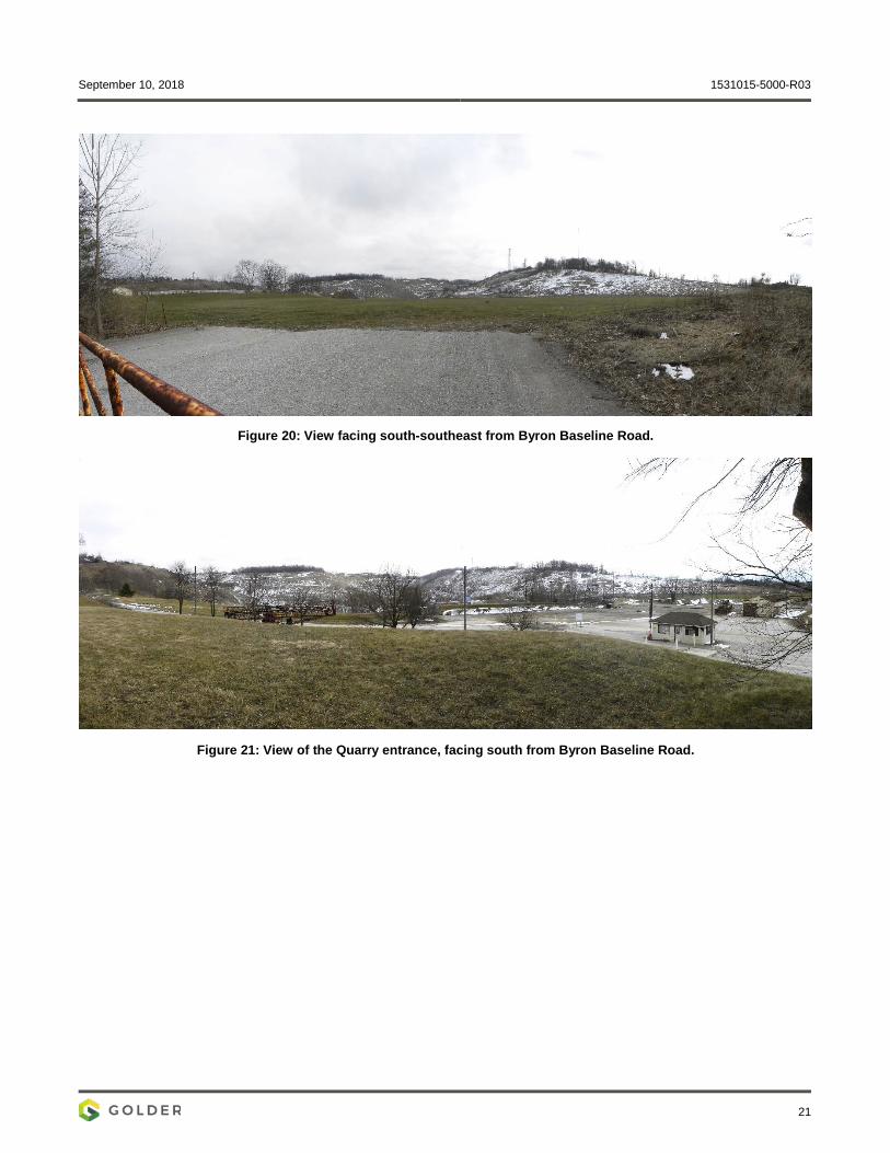
Figure 20: View facing south-southeast from Byron Baseline Road. ..................................................................... 21
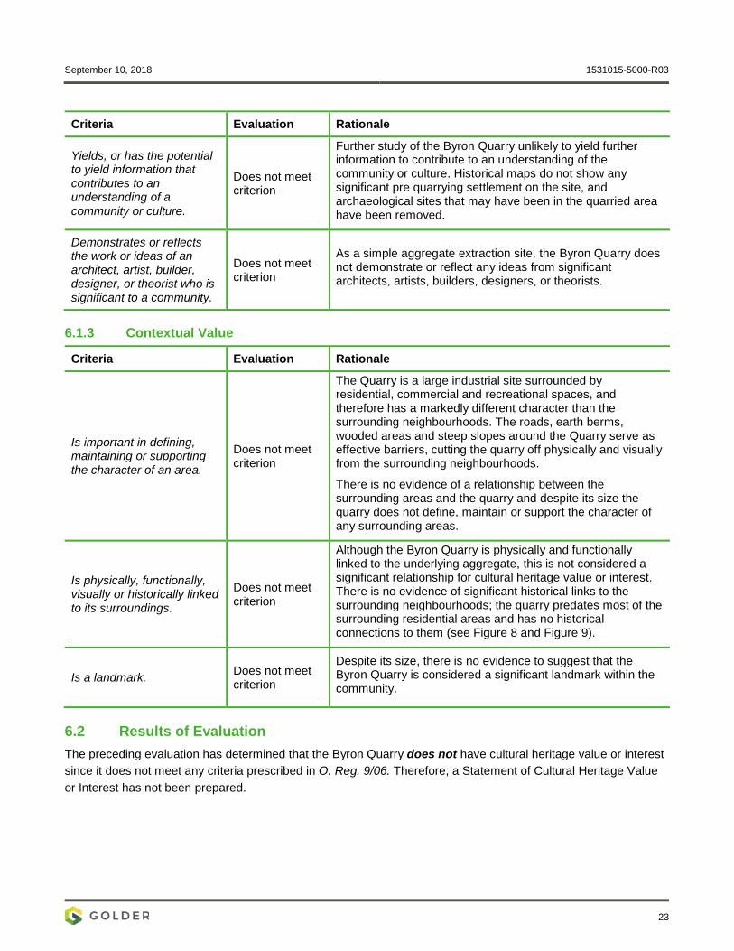
Figure 21: View of the Quarry entrance, facing south from Byron Baseline Road. ................................................ 21
September 10, 2018 1531015-5000-R03
1
1.0 INTRODUCTION In February 2018, CIMA+ retained Golder Associates Ltd. (Golder) to conduct a Cultural Heritage Evaluation Report (CHER) on the Byron Quarry as part of the environmental assessment for the proposed realignment of Commissioners Road West in the City of London, Ontario. Golder’s Heritage Impact Assessment (HIA) for the proposed realignment identified views over the quarry as a potential cultural heritage landscape according to the City of London’s Guidelines for the Identification of Cultural Heritage Landscapes (2003).
Following guidance from the Ministry of Tourism, Culture and Sport’s (MTCS) Ontario Heritage Tool Kit: Heritage Property Evaluation (2006), the City of London’s Guidelines for the Identification of Cultural Heritage Landscapes (2003), and Ontario Regulation 9/06 (O. Reg. 9/06), this report provides:
A background on the purpose and requirements of a CHER and the methods used to investigate and evaluate the property for cultural heritage value or interest (CHVI);
An overview of the geographic and historical context of the property;
An inventory of built and landscape elements on the property;
An evaluation of the property using O. Reg. 9/06; and,
Recommendations for future action.

473400
473400
473600
473600
473800
473800
474000
474000
474200
474200
474400
474400
474600
474600
474800
474800
475000
475000
1. THIS FIGURE IS TO BE READ IN CONJUNCTION WITH THE ACCOMPANYING GOLDERASSOCIATES LTD. REPORT NO. 1531015
1. BASEDATA PROVIDED BY CITY OF LONDON - DIGITAL MAPPING DISC 2014.2. PROJECTION: TRANSVERSE MERCATOR DATUM: NAD 83COORDINATE SYSTEM: UTM ZONE 17 VERTICAL DATUM: CGVD28 5000 0 1
PROJECT NO. PHASE FIGURE
CIMA+
CULTURAL HERITAGE EVALUATION REPORTBYRON GRAVEL QUARRY, LONDON, ONTARIO
SITE PLAN
CONSULTANT
REV.
2018-09-07
----
BR
BH
HJD
YYYY-MM-DD
DESIGNED
PREPARED
REVIEWED
APPROVED
1531015
REFERENCE(S)
NOTE(S)
LEGEND
STUDY AREA
PROPOSED REALIGNMENT OFCOMMISSIONERS ROAD WEST
REALIGNMENT CORRIDOR
ROAD
WATERBODY
1:10,000 METRES
0 190 38095
PROJECT
CLIENT
TITLE
September 10, 2018 1531015-5000-R03
3
2.0 SCOPE AND METHOD To conduct this CHER, Golder:
Reviewed applicable municipal heritage policies and consulted a City heritage planner;
Researched archival and published sources relevant to the property;
Conducted field investigations to document and identify any heritage attributes;
Evaluated the property using the criteria prescribed in O. Reg. 9/06; and,
Developed recommendations for future action based on international, federal, provincial, and municipal conservation guidance.
Several primary and secondary sources, including historic maps, aerial imagery, photographs, research articles, and local histories were compiled from Library and Archives Canada, the Archives of Ontario, the National Air Photo Library, local history collections, and online sources.
Field investigations Byron Quarry were conducted by Cultural Heritage Specialist Robyn Lacy on March 6, 2018 and included taking photographs of Byron Quarry with a Nikon Coolpix P90 digital camera.
Golder consulted City heritage planner Kyle Gonyou on February 7 and 8, 2018 by phone and e-mail and was informed that the City does not have enough information on the Byron Quarry to comment on its potential CHVI.
Several widely recognized manuals related to evaluating heritage value were also consulted, including:
The Ontario Heritage Tool Kit (5 volumes, MTCS 2006);
The Standards and Guidelines for the Conservation of Provincial Heritage Properties – Heritage Identification & Evaluation Process (MTCS 2014);
Seeing the History in the View, a method for assessing heritage significance within views (English Heritage 2011);
Guidelines for Identifying, Evaluating, and Registering Historic Mining Properties (U.S. NPS 1997); and,
Guidelines for Evaluating and Documenting Rural Historic Landscapes (U.S. NPS 1999).
September 10, 2018 1531015-5000-R03
4
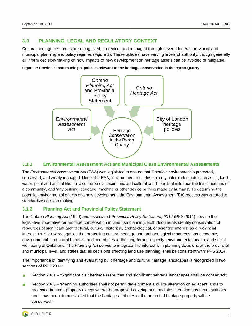
3.0 PLANNING, LEGAL AND REGULATORY CONTEXT Cultural heritage resources are recognized, protected, and managed through several federal, provincial and municipal planning and policy regimes (Figure 2). These policies have varying levels of authority, though generally all inform decision-making on how impacts of new development on heritage assets can be avoided or mitigated.
Figure 2: Provincial and municipal policies relevant to the heritage conservation in the Byron Quarry
3.1.1 Environmental Assessment Act and Municipal Class Environmental Assessments The Environmental Assessment Act (EAA) was legislated to ensure that Ontario’s environment is protected, conserved, and wisely managed. Under the EAA, ‘environment’ includes not only natural elements such as air, land, water, plant and animal life, but also the ‘social, economic and cultural conditions that influence the life of humans or a community’, and ‘any building, structure, machine or other device or thing made by humans’. To determine the potential environmental effects of a new development, the Environmental Assessment (EA) process was created to standardize decision-making.
3.1.2 Planning Act and Provincial Policy Statement The Ontario Planning Act (1990) and associated Provincial Policy Statement, 2014 (PPS 2014) provide the legislative imperative for heritage conservation in land use planning. Both documents identify conservation of resources of significant architectural, cultural, historical, archaeological, or scientific interest as a provincial interest. PPS 2014 recognizes that protecting cultural heritage and archaeological resources has economic, environmental, and social benefits, and contributes to the long-term prosperity, environmental health, and social well-being of Ontarians. The Planning Act serves to integrate this interest with planning decisions at the provincial and municipal level, and states that all decisions affecting land use planning ‘shall be consistent with’ PPS 2014.
The importance of identifying and evaluating built heritage and cultural heritage landscapes is recognized in two sections of PPS 2014:
Section 2.6.1 – ‘Significant built heritage resources and significant heritage landscapes shall be conserved’;
Section 2.6.3 – ‘Planning authorities shall not permit development and site alteration on adjacent lands to protected heritage property except where the proposed development and site alteration has been evaluated and it has been demonstrated that the heritage attributes of the protected heritage property will be conserved.’
Heritage Conservation in the Byron
Quarry
Environmental Assessment
Act
Ontario Planning Act
and Provincial Policy
Statement
Ontario Heritage Act
City of London heritage policies
September 10, 2018 1531015-5000-R03
5
PPS 2014 defines significant as resources ‘determined to have cultural heritage value or interest for the important contribution they make to our understanding of the history of a place, an event, or a people’, and conserved as ‘the identification, protection, management and use of built heritage resources, cultural heritage landscapes, and archaeological resources in a manner that ensures their cultural heritage value or interest is retained under the Ontario Heritage Act.’ Built heritage resources, cultural heritage landscapes, heritage attributes, and protected heritage property are also defined in the PPS:
Built heritage resources: a building, structure, monument, installation or any manufactured remnant that contributes to a property’s cultural heritage value or interest as identified by a community, including an Aboriginal [Indigenous] community. Built heritage resources are generally located on property that has been designated under Parts IV or V of the Ontario Heritage Act, or included on local, provincial and/or federal registers.
Cultural heritage landscapes: a defined geographical area that may have been modified by human activity and is identified as having cultural heritage value or interest by a community, including an Aboriginal [Indigenous] community. The area may involve features such as structures, spaces, archaeological sites or natural elements that are valued together for their interrelationship, meaning or association. Examples may include, but are not limited to, heritage conservation districts designated under the Ontario Heritage Act; villages, parks, gardens, battlefields, main streets and neighbourhoods, cemeteries, Trailways, viewsheds, natural areas and industrial complexes of heritage significance; and areas recognized by federal or international designation authorities (e.g., a National Historic Site or District designation, or a UNESCO World Heritage Site).
Heritage attribute: the principal features or elements that contribute to a protected heritage property’s cultural heritage value or interest, and may include the property’s built or manufactured elements, as well as natural landforms, vegetation, water features, and its visual setting (including significant views or vistas to or from a protected heritage property).
Protected heritage property: property designated under Parts IV, V or VI of the Ontario Heritage Act; property subject to a heritage conservation easement under Parts II or IV of the Ontario Heritage Act; property identified by the Province and prescribed public bodies as provincial heritage property under the Standards and Guidelines for Conservation of Provincial Heritage Properties; property protected under federal legislation, and UNESCO World Heritage Sites.
For municipalities, PPS 2014 is implemented through an Official Plan, which may outline further heritage policies.
3.1.3 Ontario Heritage Act and Ontario Regulation 9/06 The Province and municipalities are enabled to conserve significant individual properties and areas through the Ontario Heritage Act (OHA). Under Part III of the OHA, compliance with the Standards and Guidelines for the Conservation of Provincial Heritage Properties is mandatory for provincially-owned and administered heritage properties and holds the same authority for ministries and prescribed public bodies as a Management Board or Cabinet directive.
For municipalities, Part IV and Part V of the OHA enables council to ‘designate’ individual properties (Part IV), or properties within a heritage conservation district (HCD) (Part V), as being of ‘cultural heritage value or interest’ (CHVI). Evaluation for CHVI under the OHA is guided by Ontario Regulation 9/06 (O. Reg. 9/06), which prescribes the criteria for determining cultural heritage value or interest.
The criteria are as follows:
September 10, 2018 1531015-5000-R03
6
1) The property has design value or physical value because it:
i) Is a rare, unique, representative or early example of a style, type, expression, material or construction method;
ii) Displays a high degree of craftsmanship or artistic merit; or
iii) Demonstrates a high degree of technical or scientific achievement.
2) The property has historic value or associative value because it:
i) Has direct associations with a theme, event, belief, person, activity, organization, or institution that is significant to a community;
ii) Yields, or has the potential to yield information that contributes to an understanding of a community or culture; or
iii) Demonstrates or reflects the work or ideas of an architect, artist, builder, designer, or theorist who is significant to a community.
3) The property has contextual value because it:
i) Is important in defining, maintaining or supporting the character of an area;
ii) Is physically, functionally, visually or historically linked to its surroundings; or
iii) Is a landmark.
If a property meets one or more of these criteria, it may be eligible for designation under Part IV, Section 29 of the OHA.
Designated properties, which are formally described and recognized through by-law, must then be included on a ‘Register’ maintained by the municipal clerk. At a secondary level, a municipality may ‘list’ a property on the register to indicate its potential CHVI. Importantly, designation or listing in most cases applies to the entire property, not only individual structures or features.
3.1.4 Ministry of Tourism, Culture and Sport Guidance for Cultural Heritage Evaluation As mentioned above, heritage conservation on provincial properties must comply with the MTCS Standards and Guidelines for the Conservation of Provincial Heritage Properties. This report also provides ‘best practice’ approaches for evaluating cultural heritage resources not under provincial jurisdiction. For example, the Standards and Guidelines for the Conservation of Provincial Heritage Properties – Heritage Identification & Evaluation Process (MTCS 2014) provides detailed explanations of the O. Reg. 9/06 criteria and its application, while Info Bulletin 3: Heritage Impact Assessments for Provincial Heritage Properties describes how to organize the sections of an HIA and the range of possible impacts and mitigation measures.
The Province, through the MTCS, has also developed a series of products to advise municipalities, organizations, and individuals on heritage protection and conservation. One product used primarily for heritage evaluations is the MTCS Criteria for Evaluating Potential for Built Heritage Resources and Cultural Heritage Landscapes: A Checklist for the Non-Specialist (MTCS Checklist) (2015). The checklist helps to identify if a project area contains or is adjacent to known cultural heritage resources, provides general direction on identifying potential built heritage resources and cultural heritage landscapes, and aids in determining the next stages of evaluation and assessment.

September 10, 2018 1531015-5000-R03
7
One criterion listed on the MTCS Checklist is if a property or project area contains buildings or structures over 40 years old at the time of assessment. This 40-year ‘rule of thumb’ does not automatically assign cultural heritage value or interest or protection to buildings and structures older than 40 years, nor exclude those built in the last 40 years. Instead, it assumes that a property’s heritage potential increases with age. If the ‘rule of thumb’ identifies potential cultural heritage resources in a project area, the MTCS Checklist advises that a Cultural Heritage Evaluation Report (CHER) be completed to evaluate if the built element or landscape meets the O. Reg. 9/06 criteria. If the MTCS Checklist further indicates that known or potential heritage resources will be impacted by the proposed development in a project area, investigation as part of a Heritage Impact Assessment (HIA) is usually necessary.
More detailed guidance on identifying, evaluating, and assessing impact to built heritage resources and cultural heritage landscapes is provided in the Ontario Heritage Tool Kit series. Of these, Heritage Resources in the Land Use Planning Process (MTCS 2006) provides an outline for the contents of a HIA, which it defines as:
‘a study to determine if any cultural resources (including those previously identified and those found as part of the site assessment) …are impacted by a specific proposed development or site alteration. It can also demonstrate how the cultural resource will be conserved in the context of redevelopment or site alteration. Mitigative or avoidance measures or alternative development or site alteration approaches may be recommended.’
For heritage evaluations, the Ontario Heritage Tool Kit partially, but not entirely, supersedes earlier MTCS advice. Criteria to identify cultural landscapes is provided in greater detail in the Guidelines on the Man-Made Heritage Component of Environmental Assessments (1980:7), while recording and documentation procedures are outlined in the Guideline for Preparing the Cultural Heritage Resource Component of Environmental Assessments (1992:3-7). The latter document also stresses the importance of identifying and gauging the cumulative effects of a Class EA development (MTCS 1992:8).
3.2 Municipal Heritage Policies 3.2.1 The London Plan The London Plan (2016) is the City’s official plan, and states that for all planning and development the City will:
1) Promote, celebrate, and raise awareness and appreciation of London’s cultural heritage resources.
2) Conserve London’s cultural heritage resources so they can be passed on to our future generations.
3) Ensure that new development and public works are undertaken to enhance and be sensitive to our cultural heritage resources.
The London Plan is consistent with PPS 2014 and other provincial policies.

September 10, 2018 1531015-5000-R03
8
4.0 GEOGRAPHIC & HISTORICAL CONTEXT 4.1 Geographic Context The Byron Quarry is in southwestern Ontario, approximately 5.0 km southwest and in the watershed of the Forks of the Upper Thames River. The underlying bedrock of this area consists of limestone, dolostone and shale of the Dundee Formation from the Devonian period. It is within the Mount Elgin Ridges physiographic region (Chapman and Putnam 1984: 144-146). These ridges are moraines of pale brown calcareous clay or silty clay and the vales between the ridges often have alluvial deposits of gravel, sand and silt over the limestone bedrock (Chapman and Putnam 1984: 145). There are approximately 10 other aggregate pits within 10km of the Byron Quarry and dozens more within 30km, with concentrations of pits north and east of the city (Government of Ontario 2018).
There are steep slopes around the edges of the Byron Quarry, but the topography of the surrounding area is gently rolling. The site of the Quarry was a treed slope leading down towards the Thames River before quarrying operations began. The Byron Quarry is in the centre of a medium to low density residential area with some commercial land uses to the northwest and several areas of open space.
4.2 Historical Context Following the Toronto Purchase of 1787, today’s southern Ontario was within the old Province of Quebec and divided into four political districts: Lunenburg, Mecklenburg, Nassau, and Hesse. These became part of the Province of Upper Canada in 1791, and renamed the Eastern, Midland, Home, and Western Districts, respectively. The Byron Quarry was within the former Hesse District, then later the Western District, which originally included all lands in what is now southwestern Ontario west of an arbitrary line running north from the end of Long Point on Lake Erie to the southernmost point on Georgian Bay. Each district was further subdivided into counties and townships. The Byron Quarry was originally part of the County of Middlesex and Westminster Township.
4.2.1 Westminster Township Prior to 1793 when Lieutenant-Governor Simcoe travelled to Detroit on a First Nations trail through the Middlesex area known as the Detroit Path (Bates Neary 2013; H.R. Page & Co. 1878), the area was considered a vast wilderness visited only by local First Nations groups and the occasional Euro-Canadian trader. When Euro-Canadian settlement did eventually occur in the county, it was concentrated first in Township of Delaware, near the Thames River, and was followed shortly thereafter by the Townships of Westminster and London.
A portion of Westminster along the Thames River was initially surveyed by Deputy Provincial Surveyor Simon T. Z. Watson in 1809-1810. Watson ran a base line across the township from which two concessions were then laid out (Brock 2003:12-13). Settlers preferred to build homes and preform their statutory roadwork along Commissioners Road, which had been a pre-colonial trail and was already laid out and adjacent to Watsons Baseline Road (Brock 2003:13). The remainder of the township was surveyed by militia colonels Burwell and Bostwick in 1820 (Brock and Moon 1972: 567). Land settlement for the township was arranged by Colonel Talbot and land patents were issued as early as 1812 (Brock and Moon 1972). The southwest corner of the township along North Talbot Road was the first to be settled, followed by settlement along Commissioners Road, which then ended at the southeast portion of the township (Wilson and Horne 1995). By 1817, the township contained 107 houses and 428 people, and the first meeting of the Westminster Council was held. Two school houses, one grist mill and one saw mill were the only public buildings present in the township at this time (Brock and Moon 1972, p. 566).
By 1850, the population had grown to 4,525 residents, and industries included three grist mills, two carding machines, and a fulling mill (Brock and Moon 1972: 566). The London and Port Stanley Railway, which ran north-
September 10, 2018 1531015-5000-R03
9
south through the township, was fully operational by 1856 (Brock and Moon 1972: 566). Several small hamlets also were settled over the course of the 19th century, including Byron, Lambeth, Hall Mills, Pond Mills, and Glanworth (Brock and Moon 1972: 577-581).
4.2.2 The Byron Quarry The Byron Quarry is in the northern half of Lot 41, and western half of Lot 42, Concession 1, in the former Westminster Township. Mahlon Burwell’s 1820 survey map of Westminster Township indicates that the Byron Quarry was unoccupied land at that time (Figure 4). Tremaine’s 1862 map of the County of Middlesex indicates that Lot 41 was divided into quarters and the northwestern quarter —in which the Byron Quarry is located— was owned by S. Hungerford. It also shows the western half of Lot 42 owned by ‘Lord Montcastle’ (Figure 5), although in the land registry records the ownership is in the name of the ‘Earl of Mountcastle’. There was some legal dispute over the property and eventually it was owned partly by Lady Jane Moore and partly owned by the Township. In 1873, Lady Moore sold her lot to Robert Flint.
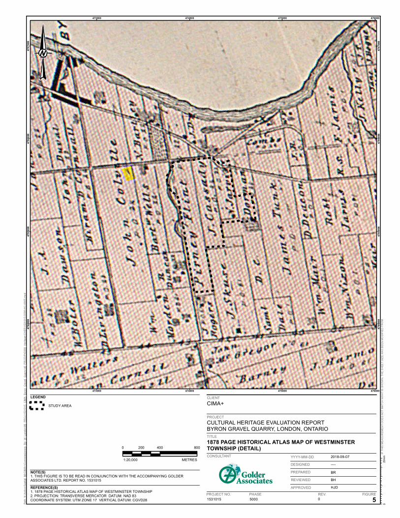
The 1878 Illustrated Historical Atlas of Middlesex County (Figure 6) indicates that Lot 41 and Lot 42 had been subdivided further. The northeastern quarter of Lot 41 was owned by D. C. Dorman, and the northwestern portion owned by N. Jarvis. Houses are depicted on the properties owned by Dorman and Jarvis. The northeast section of Lot 42 was owned by James Cassidy, the southeast section was owned by John Skuse and the northwest section of the lot was owned by Pirney Flint.
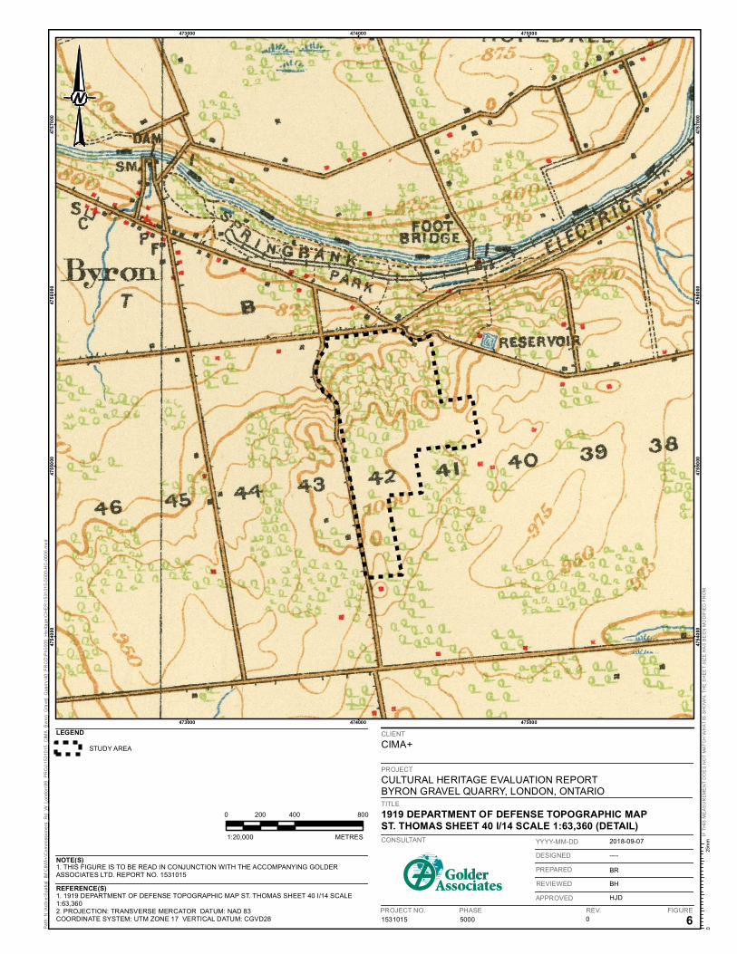
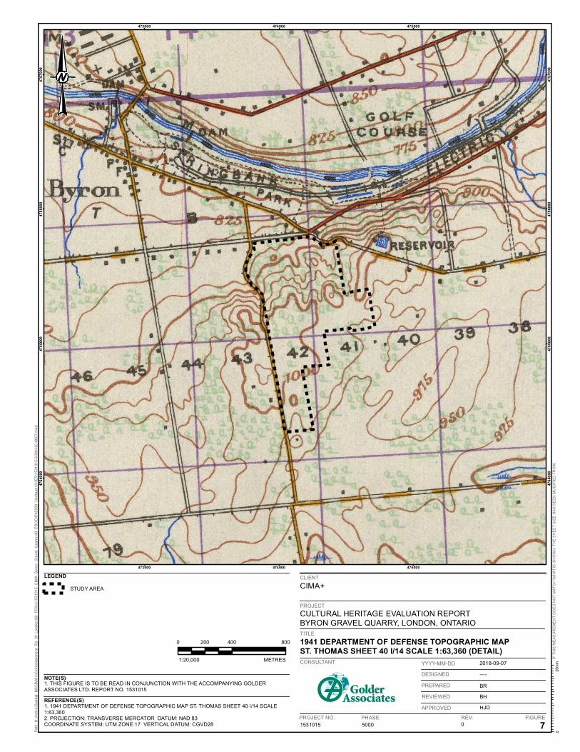
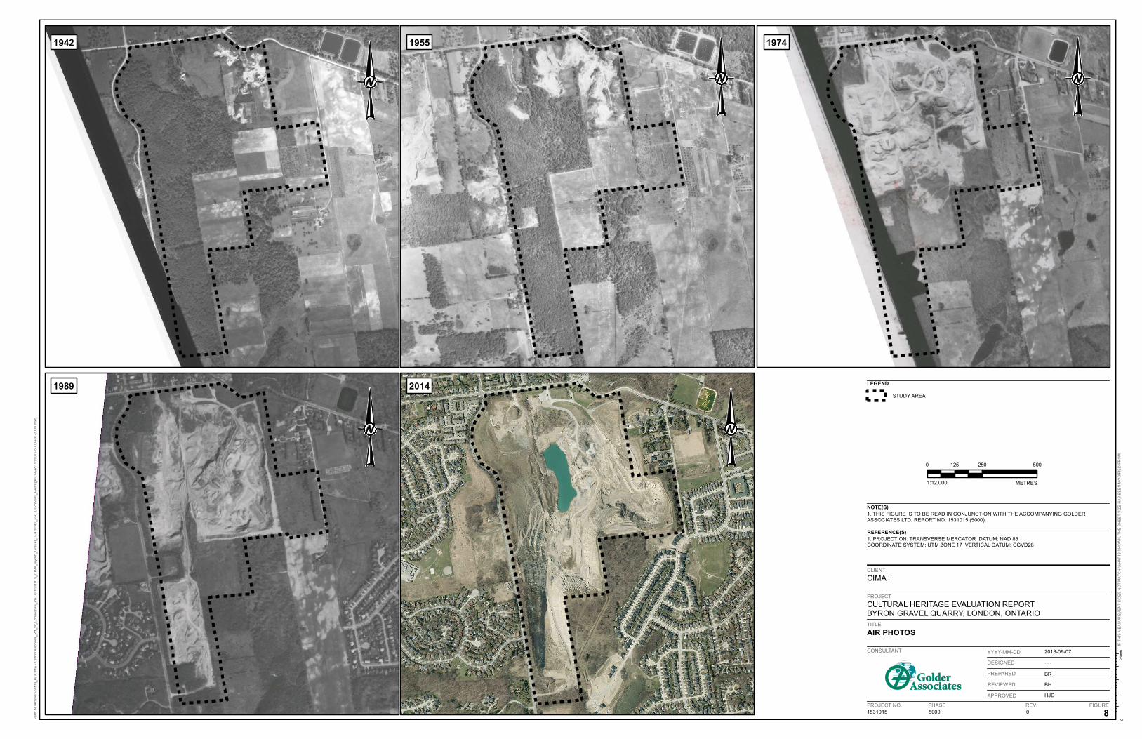
Topographic maps from 1919 and 1941 illustrate that the Byron Quarry had only one building, and it was located next to Commissioners Road in the northwestern corner of Lot 41 (Figure 7 and Figure 8). The rest of the Byron Quarry was covered in trees although the Byron Quarry, then called the Ridley Gravel Pit, had opened in the 1940s (City of London 1992:11). Aerial photographs show that some excavation was underway in 1942 in the northeast corner of the Byron Quarry, while some of the east side of the Byron Quarry was used for orchards or under cultivation. Through the remainder of the 20th century the quarry expanded to the south and west over the Byron Quarry (Figure 9). A lot of the gravel removed from the Quarry has been used to build roads in and around London (De Bono 2014). Today the Quarry is operated by Lafarge Canada Inc.

473000
473000
474000
474000
475000
475000
476000
476000
1. THIS FIGURE IS TO BE READ IN CONJUNCTION WITH THE ACCOMPANYING GOLDERASSOCIATES LTD. REPORT NO. 1531015
1. 1820 BURWELL SURVEY MAP OF WESTMINSTER TOWNSHIP.2. PROJECTION: TRANSVERSE MERCATOR DATUM: NAD 83COORDINATE SYSTEM: UTM ZONE 17 VERTICAL DATUM: CGVD28 5000 3
PROJECT NO. PHASE FIGURE
CIMA+
CULTURAL HERITAGE EVALUATION REPORTBYRON GRAVEL QUARRY, LONDON, ONTARIO
1820 BURWELL SURVEY MAP OF WESTMINSTERTOWNSHIP(DETAIL)CONSULTANT
REV.
YYYY-MM-DD
DESIGNED
PREPARED
REVIEWED
APPROVED
1531015
REFERENCE(S)
NOTE(S)
LEGEND
STUDY AREA
0
2018-09-07
----
BR
BH
HJD
1:20,000 METRES
0 400 800200
PROJECT
CLIENT
TITLE
473000
473000
474000
474000
475000
475000
1. THIS FIGURE IS TO BE READ IN CONJUNCTION WITH THE ACCOMPANYING GOLDERASSOCIATES LTD. REPORT NO. 1531015
1. 1862 TREMAINE MAP OF THE COUNTY OF MIDDLESEX2. PROJECTION: TRANSVERSE MERCATOR DATUM: NAD 83COORDINATE SYSTEM: UTM ZONE 17 VERTICAL DATUM: CGVD28 5000 4
PROJECT NO. PHASE FIGURE
CIMA+
TITLE
1862 TREMAINE MAP OF THE COUNTY OF MIDDLESEX(DETAIL)CONSULTANT
REV.
YYYY-MM-DD
DESIGNED
PREPARED
REVIEWED
APPROVED
1531015
REFERENCE(S)
NOTE(S)
LEGEND
STUDY AREA
0
2018-09-07
----
BR
BH
HJD
1:20,000 METRES
0 400 800200
CULTURAL HERITAGE EVALUATION REPORTBYRON GRAVEL QUARRY, LONDON, ONTARIO
PROJECT
CLIENT
473000
473000
474000
474000
475000
475000
476000
476000
1. THIS FIGURE IS TO BE READ IN CONJUNCTION WITH THE ACCOMPANYING GOLDERASSOCIATES LTD. REPORT NO. 1531015
1. 1878 PAGE HISTORICAL ATLAS MAP OF WESTMINSTER TOWNSHIP2. PROJECTION: TRANSVERSE MERCATOR DATUM: NAD 83COORDINATE SYSTEM: UTM ZONE 17 VERTICAL DATUM: CGVD28 5000 0 5
PROJECT NO. PHASE FIGURE
CIMA+
CULTURAL HERITAGE EVALUATION REPORTBYRON GRAVEL QUARRY, LONDON, ONTARIOTITLE
1878 PAGE HISTORICAL ATLAS MAP OF WESTMINSTERTOWNSHIP (DETAIL)CONSULTANT
REV.
2018-09-07
----
BR
BH
HJD
YYYY-MM-DD
DESIGNED
PREPARED
REVIEWED
APPROVED
1531015
REFERENCE(S)
NOTE(S)
LEGEND
STUDY AREA
1:20,000 METRES
0 400 800200
PROJECT
CLIENT
473000
473000
474000
474000
475000
475000
1. THIS FIGURE IS TO BE READ IN CONJUNCTION WITH THE ACCOMPANYING GOLDERASSOCIATES LTD. REPORT NO. 1531015
1. 1919 DEPARTMENT OF DEFENSE TOPOGRAPHIC MAP ST. THOMAS SHEET 40 I/14 SCALE1:63,3602. PROJECTION: TRANSVERSE MERCATOR DATUM: NAD 83COORDINATE SYSTEM: UTM ZONE 17 VERTICAL DATUM: CGVD28 5000 0 6
PROJECT NO. PHASE FIGURE
CIMA+
CULTURAL HERITAGE EVALUATION REPORTBYRON GRAVEL QUARRY, LONDON, ONTARIOTITLE
1919 DEPARTMENT OF DEFENSE TOPOGRAPHIC MAPST. THOMAS SHEET 40 I/14 SCALE 1:63,360 (DETAIL)CONSULTANT
REV.
2018-09-07
----
BR
BH
HJD
YYYY-MM-DD
DESIGNED
PREPARED
REVIEWED
APPROVED
1531015
REFERENCE(S)
NOTE(S)
LEGEND
STUDY AREA
1:20,000 METRES
0 400 800200
PROJECT
CLIENT
473000
473000
474000
474000
475000
475000
1. THIS FIGURE IS TO BE READ IN CONJUNCTION WITH THE ACCOMPANYING GOLDERASSOCIATES LTD. REPORT NO. 1531015
1. 1941 DEPARTMENT OF DEFENSE TOPOGRAPHIC MAP ST. THOMAS SHEET 40 I/14 SCALE1:63,3602. PROJECTION: TRANSVERSE MERCATOR DATUM: NAD 83COORDINATE SYSTEM: UTM ZONE 17 VERTICAL DATUM: CGVD28 5000 0 7
PROJECT NO. PHASE FIGURE
CIMA+
CULTURAL HERITAGE EVALUATION REPORTBYRON GRAVEL QUARRY, LONDON, ONTARIOTITLE
1941 DEPARTMENT OF DEFENSE TOPOGRAPHIC MAPST. THOMAS SHEET 40 I/14 SCALE 1:63,360 (DETAIL)CONSULTANT
REV.
2018-09-07
----
BR
BH
HJD
YYYY-MM-DD
DESIGNED
PREPARED
REVIEWED
APPROVED
1531015
REFERENCE(S)
NOTE(S)
LEGEND
STUDY AREA
1:20,000 METRES
0 400 800200
PROJECT
CLIENT
1:12,000 METRES
CIMA+
1. THIS FIGURE IS TO BE READ IN CONJUNCTION WITH THE ACCOMPANYING GOLDERASSOCIATES LTD. REPORT NO. 1531015 (5000).
1. PROJECTION: TRANSVERSE MERCATOR DATUM: NAD 83COORDINATE SYSTEM: UTM ZONE 17 VERTICAL DATUM: CGVD28
CULTURAL HERITAGE EVALUATION REPORTBYRON GRAVEL QUARRY, LONDON, ONTARIO
AIR PHOTOS
1531015 5000 0 8
2018-09-07
----
BR
BH
HJD
CONSULTANT
PROJECT NO. PHASE REV. FIGURE
YYYY-MM-DD
DESIGNED
PREPARED
REVIEWED
APPROVED
LEGEND
STUDY AREA
0 250 500125
NOTE(S)
REFERENCE(S)
CLIENT
PROJECT
TITLE
1942 1955 1974
20141989
September 10, 2018 1531015-5000-R03
16
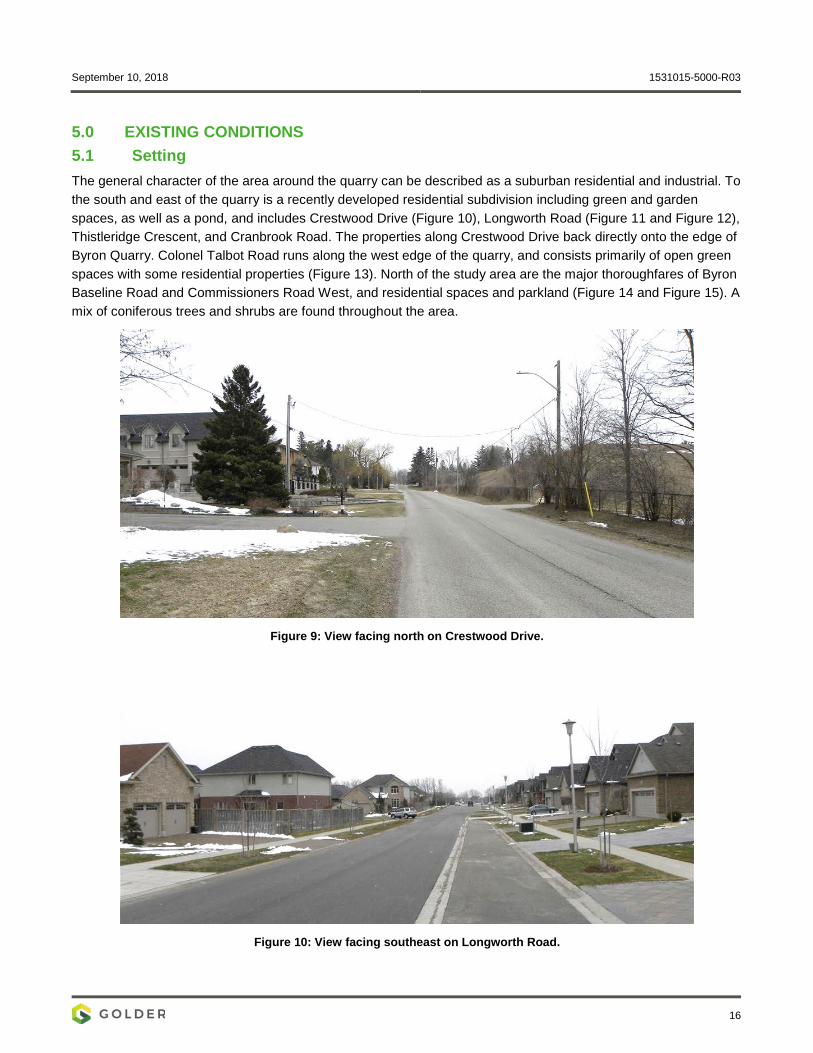
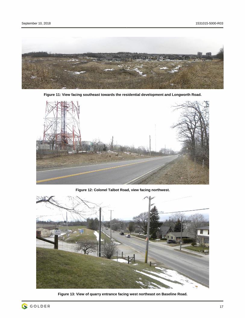
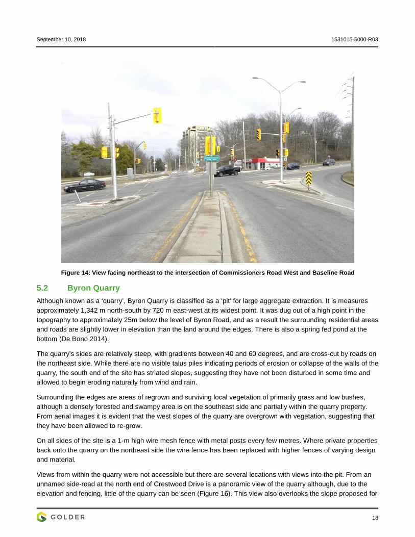
5.0 EXISTING CONDITIONS 5.1 Setting The general character of the area around the quarry can be described as a suburban residential and industrial. To the south and east of the quarry is a recently developed residential subdivision including green and garden spaces, as well as a pond, and includes Crestwood Drive (Figure 10), Longworth Road (Figure 11 and Figure 12), Thistleridge Crescent, and Cranbrook Road. The properties along Crestwood Drive back directly onto the edge of Byron Quarry. Colonel Talbot Road runs along the west edge of the quarry, and consists primarily of open green spaces with some residential properties (Figure 13). North of the study area are the major thoroughfares of Byron Baseline Road and Commissioners Road West, and residential spaces and parkland (Figure 14 and Figure 15). A mix of coniferous trees and shrubs are found throughout the area.
Figure 9: View facing north on Crestwood Drive.
Figure 10: View facing southeast on Longworth Road.
September 10, 2018 1531015-5000-R03
17
Figure 11: View facing southeast towards the residential development and Longworth Road.
Figure 12: Colonel Talbot Road, view facing northwest.
Figure 13: View of quarry entrance facing west northeast on Baseline Road.
September 10, 2018 1531015-5000-R03
18
Figure 14: View facing northeast to the intersection of Commissioners Road West and Baseline Road
5.2 Byron Quarry Although known as a ‘quarry’, Byron Quarry is classified as a ‘pit’ for large aggregate extraction. It is measures approximately 1,342 m north-south by 720 m east-west at its widest point. It was dug out of a high point in the topography to approximately 25m below the level of Byron Road, and as a result the surrounding residential areas and roads are slightly lower in elevation than the land around the edges. There is also a spring fed pond at the bottom (De Bono 2014).
The quarry’s sides are relatively steep, with gradients between 40 and 60 degrees, and are cross-cut by roads on the northeast side. While there are no visible talus piles indicating periods of erosion or collapse of the walls of the quarry, the south end of the site has striated slopes, suggesting they have not been disturbed in some time and allowed to begin eroding naturally from wind and rain.
Surrounding the edges are areas of regrown and surviving local vegetation of primarily grass and low bushes, although a densely forested and swampy area is on the southeast side and partially within the quarry property. From aerial images it is evident that the west slopes of the quarry are overgrown with vegetation, suggesting that they have been allowed to re-grow.
On all sides of the site is a 1-m high wire mesh fence with metal posts every few metres. Where private properties back onto the quarry on the northeast side the wire fence has been replaced with higher fences of varying design and material.
Views from within the quarry were not accessible but there are several locations with views into the pit. From an unnamed side-road at the north end of Crestwood Drive is a panoramic view of the quarry although, due to the elevation and fencing, little of the quarry can be seen (Figure 16). This view also overlooks the slope proposed for
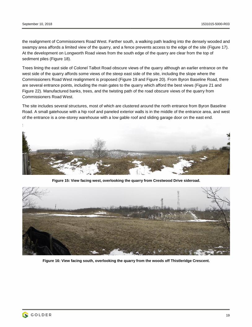
September 10, 2018 1531015-5000-R03
19
the realignment of Commissioners Road West. Farther south, a walking path leading into the densely wooded and swampy area affords a limited view of the quarry, and a fence prevents access to the edge of the site (Figure 17). At the development on Longworth Road views from the south edge of the quarry are clear from the top of sediment piles (Figure 18).
Trees lining the east side of Colonel Talbot Road obscure views of the quarry although an earlier entrance on the west side of the quarry affords some views of the steep east side of the site, including the slope where the Commissioners Road West realignment is proposed (Figure 19 and Figure 20). From Byron Baseline Road, there are several entrance points, including the main gates to the quarry which afford the best views (Figure 21 and Figure 22). Manufactured banks, trees, and the twisting path of the road obscure views of the quarry from Commissioners Road West.
The site includes several structures, most of which are clustered around the north entrance from Byron Baseline Road. A small gatehouse with a hip roof and paneled exterior walls is in the middle of the entrance area, and west of the entrance is a one-storey warehouse with a low gable roof and sliding garage door on the east end.
Figure 15: View facing west, overlooking the quarry from Crestwood Drive sideroad.
Figure 16: View facing south, overlooking the quarry from the woods off Thistleridge Crescent.

September 10, 2018 1531015-5000-R03
20
Figure 17: View facing north from the south end of the quarry, off Longworth Road.
Figure 18: View facing southeast from the northeast of Colonel Talbot Road.
Figure 19: View facing east-southeast from the northeast of Colonel Talbot Road.
Approximate location of the proposed Commissioners Road West realignment in the Quarry
Approximate location of the proposed Commissioners Road West realignment in the Quarry
September 10, 2018 1531015-5000-R03
21
Figure 20: View facing south-southeast from Byron Baseline Road.
Figure 21: View of the Quarry entrance, facing south from Byron Baseline Road.

September 10, 2018 1531015-5000-R03
22
6.0 EVALUATION OF CULTURAL HERITAGE VALUE OR INTEREST Using the results of the historical research, consultation and field investigations, the Quarry was evaluated to determine if it met the criteria for CHVI as prescribed in O. Reg. 9/06. This evaluation also draws guidance from Guidelines for Identifying, Evaluating, and Registering Historic Mining Properties (U.S. NPS 1997).
6.1.1 Design or Physical Value
Criteria Evaluation Rationale
Is a rare, unique, representative or early example of a style, type, expression, material or construction method.
Does not meet criterion
The Byron Quarry is a common open-pit aggregate quarry with no evidence that it is unique, rare, or representative in its form or features. This quarry is for common aggregate source for many roads throughout the London, and many similar aggregate pits are in the area (see Section 4.2.2 and Section 4.1).
There is no evidence that any structures in the quarry were designed specifically for quarrying operations, and the site lacks many features associated with mining sites, and there are no processing facilities; as an aggregate extraction site little processing or waste would be left on the site.
Displays a high degree of craftsmanship or artistic merit.
Does not meet criterion
The Byron Quarry does not display a high degree of craftsmanship or any artistic merit in its form or extraction method. The pit developed organically as aggregate was removed.
Demonstrates a high degree of technical or scientific achievement.
Does not meet criterion
There is no evidence that excavation in the Byron Quarry involved any special technical, engineering or scientific achievement. Aerial photographs (Figure 9) demonstrate that the quarry developed organically, spreading down and into the side of the hill to the property limits over time.
There is no evidence of significant terracing that would require a high degree of technical achievement. Common digging equipment and trucks were used to extract gravel from the pit, and no special mining equipment was required. As a simple aggregate pit no complicated technical process is required to extract the gravel.
6.1.2 Historical or Associative Value
Criteria Evaluation Rationale
Has direct associations with a theme, event, belief, person, activity, organization, or institution that is significant to a community.
Does not meet criterion
While the Byron Quarry was established in the 1940s it does not have any direct associations with any theme, event, belief, person, activity, organization, or institution that is significant to the community. There is no evidence that this quarry is associated with any prominent business or economic developments in the London area. Aggregate from the quarry has been spread across the city and surrounding area, and is not associated with any particular significant site.
September 10, 2018 1531015-5000-R03
23
Criteria Evaluation Rationale
Yields, or has the potential to yield information that contributes to an understanding of a community or culture.
Does not meet criterion
Further study of the Byron Quarry unlikely to yield further information to contribute to an understanding of the community or culture. Historical maps do not show any significant pre quarrying settlement on the site, and archaeological sites that may have been in the quarried area have been removed.
Demonstrates or reflects the work or ideas of an architect, artist, builder, designer, or theorist who is significant to a community.
Does not meet criterion
As a simple aggregate extraction site, the Byron Quarry does not demonstrate or reflect any ideas from significant architects, artists, builders, designers, or theorists.
6.1.3 Contextual Value
Criteria Evaluation Rationale
Is important in defining, maintaining or supporting the character of an area.
Does not meet criterion
The Quarry is a large industrial site surrounded by residential, commercial and recreational spaces, and therefore has a markedly different character than the surrounding neighbourhoods. The roads, earth berms, wooded areas and steep slopes around the Quarry serve as effective barriers, cutting the quarry off physically and visually from the surrounding neighbourhoods.
There is no evidence of a relationship between the surrounding areas and the quarry and despite its size the quarry does not define, maintain or support the character of any surrounding areas.
Is physically, functionally, visually or historically linked to its surroundings.
Does not meet criterion
Although the Byron Quarry is physically and functionally linked to the underlying aggregate, this is not considered a significant relationship for cultural heritage value or interest. There is no evidence of significant historical links to the surrounding neighbourhoods; the quarry predates most of the surrounding residential areas and has no historical connections to them (see Figure 8 and Figure 9).
Is a landmark. Does not meet criterion
Despite its size, there is no evidence to suggest that the Byron Quarry is considered a significant landmark within the community.
6.2 Results of Evaluation The preceding evaluation has determined that the Byron Quarry does not have cultural heritage value or interest since it does not meet any criteria prescribed in O. Reg. 9/06. Therefore, a Statement of Cultural Heritage Value or Interest has not been prepared.
September 10, 2018 1531015-5000-R03
24
7.0 SUMMARY STATEMENT AND RECOMMENDATIONS Following guidance from the Ministry of Tourism, Culture and Sport’s (MTCS) Ontario Heritage Tool Kit: Heritage Property Evaluation (2006) and O. Reg. 9/06, this report identifies the heritage policy context applicable to the Byron Quarry and summarizes the geography and history of the area. It describes the Byron Quarry, evaluates the property for cultural heritage value or interest and provides recommendations for additional cultural heritage studies if necessary.
Based on the results of archival research, field investigations, and evaluation, Golder determined that:
The Byron Quarry does not have cultural heritage value or interest; and,
No additional cultural heritage studies are required.

September 10, 2018 1531015-5000-R03
25
8.0 REFERENCES Burwell, Mahlon 1820 Part of Westminster.
Canadian Atlas Online, The 2016 Mixedwood Plains. [online] Accessed from:
http://www.canadiangeographic.ca/atlas/themes.aspx?id=mixedwoodCanada’s Historic Places
2010 Standards and Guidelines for the Conservation of Historic Places in Canada. Second Edition. Canada’s Historic Places, Ottawa.
Chapman, Lyman John and Donald F. Putnam 1984 The Physiography of Southern Ontario. 3rd edition. Ontario Geological Survey Special Volume 2. Ontario
Ministry of Natural Resources, Toronto.
City of London 1992 South-East Byron Area Study. City of London Planning Division, Department of Planning and
Development. [pdf] accessed at: https://www.london.ca/business/Planning-Development/secondary-plans/Documents/South-East-Byron-Area-Study-1992.pdf
2003 Guidelines for the Identification of Cultural Heritage Landscapes in London. City of London Planning and Development Department.
2016 The London Plan. London, Ontario. [pdf] From: http://thelondonplan.ca/
Crins WJ, Gray PA, Uhlig PWC, Wester MC. 2009 The ecosystems of Ontario, Part 1: Ecozones and Ecoregions. Ministry of Natural Resources
Peterborough Ontario, Inventory, Monitoring and Assessment, SIB TER IMA TR 01, 71pp.
De Bono, Norman 2014 Planning Staff will have to study the notion of a development with below-grade housing. The London Free
Press. [online] Accessed at: http://lfpress.com/2014/12/16/planning-staff-will-have-to-study-the-notion-of-a-development-with-below-grade-housing/wcm/0206f420-0c8a-93f7-aa8d-ae56eb3e188d
Government of Ontario 1990a Environmental Assessment Act, R.S.O. 1990, c. E.18. [online] Accessed at:
https://www.ontario.ca/laws/statute/90e18
1990b Ontario Heritage Act. Electronic document: https://www.ontario.ca/laws/statute/90o18?search=heritage+act
1990c Planning Act. Electronic document: https://www.ontario.ca/laws/statute/90p13?search=planning+act
2006 Ontario Regulation 9/06, Criteria for Determining Cultural Heritage Value or Interest. [online] Accessed at: https://www.canlii.org/en/on/laws/regu/o-reg-9-06/latest/o-reg-9-06.html
2014a Provincial Planning Statement, Under the Planning Act. Ministry of Municipal Affairs and Housing, Toronto. [online] Accessed at: http://www.mah.gov.on.ca/Page215.aspx
2018 Pits and Quarries Online. [online] Accessed at: https://www.ontario.ca/environment-and-energy/find-pits-and-quarries
September 10, 2018 1531015-5000-R03
26
Ministry of Tourism, Culture & Sport 2006 Ontario Heritage Toolkit. [online] Accessed at: http://www.mtc.gov.on.ca/en/heritage/heritage_toolkit.shtml
2014 Standards and Guidelines for the Conservation of Provincial Heritage Properties Heritage Identification & Evaluation Process. Ministry of Tourism, Culture and Sport, Toronto.
Page, H.R. and Co. 1878 Illustrated Historical Atlas of Middlesex County. H.R. Page & Co., Toronto. [online] Accessed at:
http://digital.library.mcgill.ca/countyatlas/SearchMapframes.php
Tremaine, George R. 1862 Tremaine’s Map of the County of Middlesex. George C. Tremaine., Toronto.
United States Department of the Interior National Park Service (U.S. NPS) 1997 Guidelines for Identifying, Evaluating, and Registering Historic Mining Properties. National Register
Bulletin. [pdf].
1999 Guidelines for Evaluating and Documenting Rural Historic Landscapes. National Register Bulletin. [pdf].
September 10, 2018 1531015-5000-R03
Signature Page
Golder Associates Ltd.
Benjamin Holthof, M.Pl., M.M.A., CAHP Hugh Daechsel, M.A. Cultural Heritage Specialist Principal, Senior Archaeologist
BH/HJD/cr/ly
Golder and the G logo are trademarks of Golder Associates Corporation
\\golder.gds\gal\london\active\2015\3 proj\1531015 cima_commissioners rd w realignment_london\ph 5000-heritage\2018 work\r03 draft cher\1531015-5000-r03 (final) cher commissioners rd
w sept 10 2018.docx

golder.com