Embed Size (px)
Citation preview
Report for Canning Bridge PrecinctStrategic and Statutory Framework
Report
October 2009
Prepared by:
Prepared for:

ii61/22183 Canning Bridge Rail Station Precinct StudyStrategic and Statutory Framework Report
This document has been prepared by GHD to provide background information for the Canning Bridge Precinct Vision Study and does not havethe formal endorsement of the Western Australian Planning Commission, City of Melville or the City of South Perth.
This document is and shall remain the property of GHD. The document may only be used for the purpose for which it was commissioned and inaccordance with the Terms of Engagement for the commission. Unauthorised use of this document in any form whatsoever is prohibited.
iii61/22183 Canning Bridge Rail Station Precinct StudyStrategic and Statutory Framework Report
Contents
1. Introduction 4
2. Strategic and Statutory Framework 5
2.1 State and Regional Policy 5
2.2 City of Melville Plans, Policies and Strategies 10
2.3 City of South Perth Plans, Policies and Strategies 18
3. References 25
Figure IndexFigure 1 – City of Melville CPS Zoning 12Figure 2 – City of Melville Draft Local Planning Strategy 2008 -
2023 14Figure 3 – City of South Perth TPS Zoning 19Figure 4 – City of South Perth Draft Local Commercial Strategy 20
AppendicesA Draft State Planning Policy 3.6 – Developer Contributions for
Infrastructure

461/22183 Canning Bridge Rail Station Precinct StudyStrategic and Statutory Framework Report
1. Introduction
This document provides the Background Reporting to the Canning Bridge Precinct Vision Report andshould be read in conjunction with that document.

561/22183 Canning Bridge Rail Station Precinct StudyStrategic and Statutory Framework Report
2. Strategic and Statutory Framework
2.1 State and Regional Policy
2.1.1 Directions 2031 Draft Spatial Framework for Perth and Peel
Directions 2031 Draft Spatial Framework for Perth and Peel (Directions 2031) was released in Draft forPublic Comment in June 2008. The document’s purpose is to ‘spatially define how we think the cityshould grow, identify structural changes necessary to support that growth, and identify planning andpolicy priorities for implementation’. Directions 2031 is intended to guide development within the Perthand Peel Metropolitan Region over the next 22 year period.
The framework identifies key policy and planning actions required, some of which are well advanced.These include the draft activity centres policy, preparation of growth management strategies, sub-regional structure plans and the development of a metropolitan public transport strategy.
This policy document is based on the six key themes of a liveable city, a prosperous city, an equitablecity, an accessible city, a green city and a responsible city.
Directions 2031;
» gives priority to nearly 18,600 hectares of land already zoned for urban development in Perth andPeel;
» identifies areas as under investigation for possible urban development;
» targets 47% of urban growth from infill development (121,000 new dwellings) in the inner and middlesuburbs;
» increases the average gross density for greenfield development from 10 dwellings per gross hectareto 15; an
» ensures that minimum densities of development are achieved at key activity centres and transportnodes.
Directions 2031 indicates the following for the Canning Bridge Precinct:
» The Canning Bridge Precinct is located in the Central Sub-Region;
» The Central Sub-Region is intended to accommodate an additional 205,000 people and 121,000dwelling by 2031 which equates to a 29% growth;
» The Central Sub-Region is intended to provide an additional 147,000 jobs and accommodate anadditional 127,000 people for the labour force by 2031; and
» Canning Bridge is identified as a District Town Centre.
2.1.2 Draft State Planning Policy: Activity Centres for Perth and Peel
Also released in June 2009 is the WAPC’s Draft Statement of Planning Policy: Activity Centres for Perthand Peel (Activity Centres Policy). The Activity Centres Policy has emerged generally from a number ofprevious policy and strategy documents and is consistent with the Directions 2031 document.
661/22183 Canning Bridge Rail Station Precinct StudyStrategic and Statutory Framework Report
The draft Activity Centres Policy introduces more effective measures to promote the growth of activitycentres of all scales throughout the Perth and Peel region than the current Metropolitan Centres Policy.
It provides a framework to coordinate the location, planning and future development of retail andcommercial centres. A key objective is to guide and consolidate the future non-industrial employment,including retail, into defined nodes that contain a compatible mix of services and economic activities andare well-located to the public transport system.
The draft Activity Centres Policy particularly aims to provide a more flexible regulatory approach toenable appropriate commercial, residential, mixed business and retail redevelopment opportunities inactivity centres, with a much reduced emphasis on retail floor space guidelines. It also promotes goodurban design and integration of land use and public transport, while seeking to broaden the economicbase of centres to offer a wider range of services and employment.
2.1.3 Network City: Community Planning Strategy for Perth and Peel
The Network City: Community Planning Strategy for Perth and Peel (Network City) was released inSeptember 2004. Whilst this document is not the precursor to Direction 2031, a number of key elementsare consistent and it provided the basis for early assumptions made within the Canning Bridge RailStation Precinct Study.
Therefore, the Precinct planning process considered the various policy strategies and actions that areoutlined in Network City. In particular, the following strategies and actions were identified as havingparticular relevance to this project:
» developing areas at selected locations along activity corridors to support the development of thepublic transport network with strong centres at the ends of each corridor;
» encouraging mixed-use development in areas, including higher density residential developments andemployment generators, especially where centres are well served by public transport and have highamenity, walkable environments;
» plan for local places to develop identity and pride, and to increase social and cultural capital, byengaging the community in decision making;
» provide places with distinctive qualities, and with a role and a purpose, that differentiates them withinthe city;
» revitalise existing centres and suburbs by enhancing their amenity and attractiveness, their economic,social and cultural vitality, and their safety and security;
» encourage the local mixing of uses, to reduce the overall need for people to travel between theirplaces of residence, employment and recreation; and
» build new, and revitalise existing, employment centres.
Network City identified Canning Bridge as an area along an activity corridor within an older area that mayhave opportunities to strengthen networks and centres. In this respect, Canning Bridge is a locationwhere a range of activities are encouraged. Employment, retail, living, entertainment, higher education,high level or specialised medical services are a few activities that are encouraged in these precinctsunder Network City. The general intent along activity corridors is to encourage higher density housingand a mix of uses to facilitate the development of communities serviced by a high level of publictransport.
761/22183 Canning Bridge Rail Station Precinct StudyStrategic and Statutory Framework Report
These elements of Network City are consistent with the objectives of Directions 2031.
2.1.4 State Planning Policy No. 4.2 – Metropolitan Centres Policy Statement for the PerthMetropolitan Region (Currently Under Review)
This policy document was the pre-cursor to the Draft Statement of Planning Policy: Activity Centres forPerth and Peel. The principal purpose of this policy was to provide a broad regional planning frameworkto coordinate the location and development of retail and commercial activities in the metropolitan region.It was mainly concerned with the location, distribution and broad design criteria for the development ofcommercial activities at the regional and district level.
The Canning Bridge Precinct was identified as a District Centre under the hierarchy set by this policy.District Centres were promoted as centres serving the weekly shopping and service needs of thesuburban population, providing mainly convenience goods, a range of comparison goods, local servicesand local employment. Retail shopping floor space was generally confined to 15,000m2 unless consistentwith a WAPC endorsed Local Planning Strategy or centre plan.
District level offices, such as professional, sales and service offices were also provided at theselocations. Whilst this policy document generally intended to manage development in commercial centresit was noted for having prescriptive floor space guidelines which are now considered more flexibly in theDraft Activity Centres Policy.
2.1.5 Liveable Neighbourhoods (Edition 3)
Liveable Neighbourhoods is an operational policy for the design and assessment of structure plans(regional, district and local) and subdivision, strata subdivision and development for new urban(predominantly residential) areas in the metropolitan area and country centres.
Liveable Neighbourhoods is a response to changing neighbourhood design approaches, and focuses onthe idea of an urban structure based on walkable mixed use neighbourhoods with interconnected streetpatterns to facilitate movement and to disperse traffic. With good design, more people will actively uselocal streets, enhancing safety.
Local employment opportunities are facilitated in the town structure, providing the community with afirmer economic base and enhancing self containment of neighbourhoods and towns. Safe, sustainableand attractive neighbourhoods are the result, with a strong site-responsive identity supportive of localcommunity.
The document outlines eight elements that address neighbourhood design, including:
» community Design;
» movement Network;
» lot Layout;
» public Parkland;
» urban Water Management;
» utilities;
» Activity Centres and employment; and
» schools
861/22183 Canning Bridge Rail Station Precinct StudyStrategic and Statutory Framework Report
For each element, objectives and requirements have been developed to guide urban development andthe creation of more walkable and sustainable neighbourhoods.
2.1.6 Development Control Policy 1.6 – Planning to Support Transit Use and Transit OrientedDevelopment
The policy ‘Planning to Support Transit Use and Transit Oriented Development’ (DC 1.6) seeks tomaximise the benefits to the community of an effective and well used public transit system by promotingplanning and development outcomes that will support and sustain public transport use, and which willachieve the more effective integration of land use and public transport infrastructure.
The following policy measures are applicable to this study and study area.
» A diversity of lot sizes in subdivisions within transit oriented precincts, matched with a robust streetlayout, is encouraged as it provides greater flexibility of development options, and enhances therobustness of the urban structure, making it easier for the precinct to evolve over time through aprogressive intensification of activities and change to uses that will more effectively support transituse.
» Continuity of footpaths should be ensured along both sides of any street within transit precincts.Neighbourhood layouts should be planned to avoid pedestrians having to cross major roads, or totraverse or be forced out of their direct way to by-pass other obstacles to access transit facilities.
» Development should be designed to facilitate access to and enhance the legibility of transit facilities.There may be opportunities for the physical integration of developments with transit infrastructure,incorporating uses that support the station, for example retail uses that will provide services to, andbenefit from the custom of transit users.
» The design of developments, especially in proximity to stations, should be robust, to allow for the useof buildings to change over time, to uses that may be more appropriate to a transit-oriented precinctand supportive of transit use.
The implementation of the policy is integral to the process of Town Planning Scheme, MetropolitanRegion Scheme, and local planning policy development and review. It is aligned closely with Directions2031 and the principles of TOD development.
The policy is also expected to be considered in the determination of development applications for thesubdivision, development of land and redevelopment of existing areas within transit oriented localities asidentified by the Network City Framework.
2.1.7 Designing Out Crime Guidelines
The Designing out Crime Guidelines were published in 2006 by the Western Australian PlanningCommission (WAPC) in response to the growing body of research that supports the positive impact ofimprovements to lighting, fencing, surveillance, access control, territoriality or a sense of place,neighbourhood clean-ups and vehicular and non-vehicular movement networks on reducing opportunitiesfor crime.
The principal purpose of the guidelines is to provide local government, government agencies, towncentre management, the public and private sector development industry and planning and designpractitioners, with a context for understanding the principles of designing out crime and a toolbox ofdesign criteria and approaches to address crime prevention in their local areas.

961/22183 Canning Bridge Rail Station Precinct StudyStrategic and Statutory Framework Report
The guidelines group the designing out crime principles into five concepts:
» Surveillance;
» Access control;
» Territorial reinforcement;
» Target hardening; and
» Management and maintenance.
The guidelines outline development principles for each of these concepts that can be utilised to helpreduce crime and anti-social behaviour in the community and build a sense of place within communitiesand developments. The guidelines also provide a ‘toolbox’ with performance criteria for each of the fiveconcepts that should be followed.
2.1.8 Integrated Regional Transport Plan for South West Metropolitan Perth
The South West Metropolitan Integrated Transport Plan (SW ITP) was developed by the South WestGroup members, including the City’s of Melville (COM), Cockburn, Rockingham, East Fremantle andKwinana, along with neighbouring cities of Fremantle, Mandurah and Canning, plus the Department ofPlanning (DP) and the Public Transport Authority (PTA).
The document establishes a vision towards the regional transport system for the South Westmetropolitan area. Key recommendations relating to this study include:
» Develop a transit-oriented precinct plan for each rail station precinct based on LiveableNeighbourhood Guidelines, in partnership with the DPI.
» Canning Highway bus priority lanes (Riseley Street to Canning Bridge).
Opportunities for introducing bus priority lanes along certain sections of Canning Highway wereinvestigated in the report and were generally supported.
2.1.9 State Planning Policy 2.10 – Swan Canning River System
State Planning Policy (SPP) 2.10 applies to the Swan and Canning rivers and their immediatesurroundings and aims to provide a context for consistent and integrated planning and decision makingin relation to the river and to ensure that activities, land use and development maintain and enhance thehealth, amenity, and landscape values of the river, including its recreational and scenic values. A set ofguiding principles have been developed that the policies are based on that revolve around socialbenefits, environmental values, cultural and natural heritage and design and development.
The SPP divides the river system in separate parts, of which the relevant part to this project is the LowerCanning. It describes the Lower Canning (particular to this study area) as having some of the bestestuarine vegetation of the Swan-Canning catchment with popular recreational uses of rowing, waterskiing and other aquatic activities. The many landscape features include the public infrastructure of theCanning Bridge, the Kwinana Freeway and some significant commercial development at the CanningBridge; however, primarily the area has a suburban character with low density development, maturetrees and a natural river foreshore.
The relevant policy measures for this area are:
» Protect views from public spaces, particularly from Canning Bridge;

1061/22183 Canning Bridge Rail Station Precinct StudyStrategic and Statutory Framework Report
» protect places of cultural significance, in particular places on the Register of Heritage Places and theDepartment of Indigenous Affairs register of significant places;
» ensure that commercial development on the foreshore reserve is confined to existing recreationnodes and in accordance with an adopted Swan-Canning precinct plan for the area;
» enhance recreational opportunities where access is limited; and
» ensure that the scale and density of new residential development blends harmoniously with the leafy,suburban character and predominantly natural features of the landscape.
2.1.10 Draft State Planning Policy 3.6 Development Contributions for Infrastrcuture
The draft State Planning Policy 3.6: Development Contributions for Infrastructure outlines the principlesand imposition of development contributions, with one of the key objectives of the policy focused on thepromotion of efficient and effective provision of public infrastructure and facilities to meet the demandsarising from new growth and development.
According to the policy, development contributions may relate to the requirements of utility providers,state government requirements and the requirements of local government. Developer’s contributionsfrom all new development initiatives in the Precinct could be utilised to establish streetscapes, otherpublic space improvements and required infrastructure upgrades in the form of land contributions andinfrastructure works, as outlined in Appendix 1 of the policy (see Appendix A).
2.2 City of Melville Plans, Policies and Strategies
2.2.1 City of Melville Community Planning Scheme No. 5
The CoM Community Planning Scheme No. 5 (‘the Scheme’) identifies a majority of the COM section ofthe Precinct as being within the ‘Canning Bridge Frame Commercial Precinct’ and ‘Canning BridgeDistrict Centre Precinct’ (see Figure 1).
The Statement of Intent for the Canning Bridge Frame Commercial Precinct is:
“Primarily residential but may include offices and medical practitioners where privacy of neighbours isrespected and design has a residential character. Buildings shall not use reflective or mirror glassexternally. Shops, open-air display of goods and vehicles, service stations and the like are prohibited.The Council may prepare urban design guidelines for the precinct”.
The Statement of Intent for the Canning Bridge District Centre Precinct is:
“Primarily retail shopping, tourist facilities, motel/hotel, offices, and licensed premises, with residentialuse encouraged. Access to the car parking areas on Lots 1, 2 and 3 Canning Highway and Lot 6 SleatRoad over Lot 5 Sleat Road, shall be maintained at all times. The Council may prepare urban designguidelines for the precinct”.
Further, Section 2.4.5 (b) of the Scheme states:
“To achieve the greatest available range of commercial facilities for the residents and workforce in theCity, proposals for new centres and for the growth of existing centres shall be assessed within the
1161/22183 Canning Bridge Rail Station Precinct StudyStrategic and Statutory Framework Report
context of the Local Commercial Strategy. This will be subject to the preparation of social and economicneed analysis and urban design studies that include consideration of the interface with adjoining areas”.
In consideration of the above, this study also considers the adjoining areas to the study, which aregenerally the Applecross Precinct to the north, the River Foreshore and Mt Pleasant Precinct to the southand the Canning Highway Precinct to the west.
The Statement of Intent for these Precincts is listed below:
» Applecross Precinct – primarily low density residential but may include home occupations, cornershops, parks, religious, recreational and educational activities, provided they are not developed tosuch an intensity that they disturb the precinct or are out of character with it.
» River Foreshore Precinct – primarily low density residential but may include home occupations,parks, religious, recreational, educational and community uses provided they are not developed tosuch an intensity that they disturb the Precinct or are out of character with it. A low density andmoderate landscaping and setback requirements provide a buffer transition area adjoining the river.Development should be designed with minimum possible earthworks to maintain existing landform.All non residential uses shall be advertised in accordance with Clause 7.5, provided that homeoccupations shall be determined in accordance with Clause 5.6.
» Mt Pleasant Precinct – primarily low density residential but may include home occupations, cornershops, parks, religious, recreational and educational activities, provided they are not developed tosuch an intensity that they disturb the precinct All non-residential uses shall be advertised inaccordance with Clause 7.5, provided that home occupations shall be determined in accordance withClause 5.6.
» Canning Highway Precinct – primarily medium density residential to take advantage of good publictransport links but may include other activities such as home occupations, parks, religious, publicrecreational, educational and medical uses, provided they are designed in a residential style and arenot developed to such an intensity that they disturb the precinct.
The City of Melville is currently progressing its City of Melville Local Planning Scheme No. 6 tosupersede this statutory document.

1261/22183 Canning Bridge Rail Station Precinct StudyStrategic and Statutory Framework Report
Figure 1 – City of Melville CPS Zoning
2.2.2 Proposed Amendment No. 35
Amendment No. 35 to Community Planning Scheme No. 5 was prepared and proposed to update theCity’s Community Planning Scheme to reflect the actual density and plot ratio of the Raffles developmentand increase the density, plot ratio, height limits and boundaries of the Canning Bridge Precinct.
The amendment generally proposed:
» Variation to the boundary of the Canning Bridge District Centre precinct;
» Division of the Canning Bridge District Centre precinct into three (3) sub precincts with provision fornew and varied development requirements; and
» Increased R-codes of both the Canning Bridge District Centre and Frame.
Thirty-seven (37) submissions were received from the community on Amendment No. 35. Of these, 19were generally in support of the amendment, 17 objected to the amendment or part of the amendmentand one submission provided no comment.
The Amendment is likely to be reviewed as a result of this Precinct planning process, and as a result isnot being considered formally at this time.
1361/22183 Canning Bridge Rail Station Precinct StudyStrategic and Statutory Framework Report
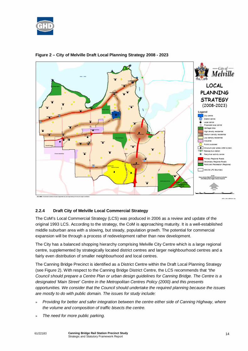
2.2.3 Draft Local Planning Strategy 2008 - 2023
The City of Melville Local Planning Strategy 2008 – 2023 (see Figure 2) is proposed to be the keystrategic urban planning document for the City of Melville and as such would complement the proposedMelville Local Planning Scheme No. 6. This document is still in Draft.
The intent of the Local Planning Strategy is to provide a long-term vision for sustainable planning thatintegrates diverse issues such as
» residential densities,
» activity centres and corridors,
» community hubs,
» transport corridors
» environmental resources.
The Strategy’s vision is for 10 -15 years into the future and in particular proposes to address thefollowing issues:
» A description of the key characteristics of the municipality, its regional context.
» A statement of goals explaining the strategic land use directions which the Council is seeking topursue.
» Land use and development issues which provide a context for local planning decisions.
» The links between strategic planning in the municipality and state and regional planning context.
» Strategic policy statements about issues such as housing, business and industry, open space andrecreation, transport, infrastructure and environment.
» More detailed strategies for particular areas in the municipality.
» An outline of how the strategy will be implemented including reference to any local planning policiesand guidelines which may be required, planning scheme measures and proposals pf the StateGovernment and Council to facilitate development (including capital works).
1461/22183 Canning Bridge Rail Station Precinct StudyStrategic and Statutory Framework Report
Figure 2 – City of Melville Draft Local Planning Strategy 2008 - 2023
2.2.4 Draft City of Melville Local Commercial Strategy
The CoM’s Local Commercial Strategy (LCS) was produced in 2006 as a review and update of theoriginal 1993 LCS. According to the strategy, the CoM is approaching maturity. It is a well-establishedmiddle suburban area with a slowing, but steady, population growth. The potential for commercialexpansion will be through a process of redevelopment rather than new development.
The City has a balanced shopping hierarchy comprising Melville City Centre which is a large regionalcentre, supplemented by strategically located district centres and larger neighbourhood centres and afairly even distribution of smaller neighbourhood and local centres.
The Canning Bridge Precinct is identified as a District Centre within the Draft Local Planning Strategy(see Figure 2). With respect to the Canning Bridge District Centre, the LCS recommends that “theCouncil should prepare a Centre Plan or urban design guidelines for Canning Bridge. The Centre is adesignated ‘Main Street’ Centre in the Metropolitan Centres Policy (2000) and this presentsopportunities. We consider that the Council should undertake the required planning because the issuesare mostly to do with public domain. The issues for study include:
» Providing for better and safer integration between the centre either side of Canning Highway, wherethe volume and composition of traffic bisects the centre.
» The need for more public parking.
1561/22183 Canning Bridge Rail Station Precinct StudyStrategic and Statutory Framework Report
» Integration with public transport.
» Legibility of the centre as a whole.
» Landscape, urban design and community benefit.
» Heritage protection.
» Promoting appropriate mixes of development in the ‘Frame’ that extend the commercial functions ofthe centre while being harmonious and compatible with the amenity of adjoining residential areas.”(Page iv).
This study addresses the above issues in a broad context as they relate to the greater Canning Bridgestudy area.
2.2.5 Draft City of Melville Transport Strategy
The Draft CoM Transport Strategy (TS) was completed in 2000 at was intended to be a general outlinefor a range of activities to improve the City for its residents and other uses. The TS was not targeted atindividual locations. The vision for transport identified in the TS is that ‘transport will contribute to thequality of life and economic development in the CoM with minimum adverse effects on residents and thenatural environment. A variety of safe, affordable and effective transport modes will be available for allsectors of the community.’
The TS identified the general transport issues for the CoM, outlined below:
» Increasing congestion on the major road system;
» Poor public transport patronage;
» Road crashes;
» Parking demand issues where in some areas cars either park in other streets or circulate;
» Poor pedestrian and walking environments;
» Unnecessary vehicle movements in residential streets;
» Impact of traffic on residences and other uses;
» Poor accessibility for people without access to private cars; and
» Poor accessibility for people with disabilities.
Whilst identifying strategies to combat these specific issues, the TS also identified strategies to integratetransport and land use to ensure that land use supports public transport, walking, cycling, andaccessibility through the use of mixed use developments and attractive precincts. The TS also identifiedimproved and alternative public transport options such as a ferry service in the Canning Bridge area.
2.2.6 City of Melville Community Plan
The Community Plan for the City of Melville 2007-2017 creates a vision for the next ten years, examinespresent opportunities and challenges and then shows how they may be achieved. The plan outlines thecommunity vision for the future:
» A safe attractive City where the consequences of our actions for future generations are taken intoaccount;

1661/22183 Canning Bridge Rail Station Precinct StudyStrategic and Statutory Framework Report
» Natural and built facilities are accessible to everyone; and
» A sense of place and community spirit is generated through opportunities to participate in decisions.
The community plan was a broad and dynamic consultative process that included focus group meetingswith a selection of participants from each Ward; a workshop with the Youth Advisory Committee,interviews with key stakeholders, a community forum open to all previous participants, 9000 communitysurveys, and an interactive website dedicated to the project.
The key actions that were identified that are relevant to this study include:
» Ensure that new designs and developments provide for a safe and secure environment;
» Ensure urban design of the community reduces the impact of anti-social behaviour;
» Promote opportunities for local communities to be involved in decisions that affect their lives;
» Encourage art, culture and heritage;
» Create active commercial centres connected with surrounding neighbourhoods;
» Plan for and maintain a network of shared use paths, footpaths and cycleways;
» Plan activity centres and medium density housing around transport hubs;
» Promote and ensure sustainable urban and building design; and
» Ensure neighbourhood activity centres are maintained close to residential areas and access isenhanced so that the community can utilise shopping, employment and leisure opportunities bywalking and cycling as well as by road.
2.2.7 City of Melville Policy 28-004 – Canning Highway
The COM Policy for the Canning Highway was developed to guide development along Canning Highway.The policy focuses on the interrelationship between the highway as a regional road and its adjoininguses in terms of urban design and amenity. The most relevant development strategies to the CanningBridge Precinct are as follows:-
» Encourage medium density residential development so as to assist housing diversity/choice, takeadvantage of public transport and to contribute towards the creation of ‘urban village’ environments;
» That commercial centres and their frame precincts have development of a high standard, integratedand cohesive. Attention to the interface between non-residential development and residentialdevelopment and to the quality of mixed use development is important; and
» All development is to have regard to the fostering of pedestrian and cycle networks and facilities.
The policy also outlines design principles such as optimisation of landscaping, the retention of maturetrees and other established vegetation, minimisation of vehicular crossovers and of frontage parking andpedestrian links with the highway.
2.2.8 City of Melville Policy 06-025 – Mixed Use Development
The Mixed Use Development policy was created to guide mixed use development in the COM. Itprovides further criteria that development is to accommodate, such as plot ratio, parking, setbacks,landscaping, design and signage.

1761/22183 Canning Bridge Rail Station Precinct StudyStrategic and Statutory Framework Report
2.2.9 City of Melville Sustainable Residential Design Policy
The purpose of this policy is to encourage the development of sustainable residential buildings. Thegeneral objectives are:
» Encourage building design and siting which takes advantage of climatic factors and reduceshousehold energy requirements.
» Encourage a high standard of sustainable design, both functional and aesthetic, which takes dueregard of the needs of occupants, neighbours and the availability of local amenities.
» Encourage development which is sympathetic to the topography of the land and the scale andcharacter of surrounding development.
» Ensure that the development minimises waste.
» Ensure that the development conserves water.
» Permit a variety of housing forms so as to promote a wider choice in housing and satisfy the demandof a variety of household types and lifestyles.
» To promote the attitude of the Council to sustainable residential design to developers, builders andlandowners.
The policy addresses aspects such as energy efficiency, water conservation and landscaping, indoor airquality, and home safety.
2.2.10 City of Melville Sustainable Residential Design Guidelines
These guidelines, developed by the COM, have been created to provide residents with ideas to improveyear round comfort levels while saving money and contributing to greenhouse gas reduction. Theguidelines provide the guiding principles on building for sustainability and the benefits of sustainablebuilding. The guidelines address site selection, energy, water, layout, ventilation, insulation, materials,safety and waste reduction and provide sustainable development ideas.
2.2.11 Canning Bridge Precinct Traffic Study
A traffic study of the Canning Bridge Precinct was undertaken by Worley Parsons in August 2005 for theCOM. The Canning Bridge Precinct Traffic Study was commissioned in order to examine the impacts ofproposed Scheme Amendment No. 35. A summary of some the key issues relating to this Study isprovided below:-
» The new Canning Bridge Station may create demand for park and ride within the Precinct. This maybe occurring to a small extent at present on the eastern side of the Freeway. Demand to park n ridewithin the Canning Bridge Precinct is likely to be small due to the area’s distance from the station andparking fees.
» Buses operating on Canning Highway currently experience delay during peak times due tocongestion;
» There are currently no stops within close proximity to the Raffles site.
» Canning Highway forms a significant barrier for cyclists within the Precinct. Within the Precinct thereare only three safe highway crossing points. The pedestrian overpass at Ogilvie Road requires
1861/22183 Canning Bridge Rail Station Precinct StudyStrategic and Statutory Framework Report
cyclists to dismount prior to crossing however cyclists can cross safely using the underpass atCanning Bridge or at the Sleat Road signalised intersection.
2.3 City of South Perth Plans, Policies and Strategies
2.3.1 City of South Perth Town Planning Scheme No. 6
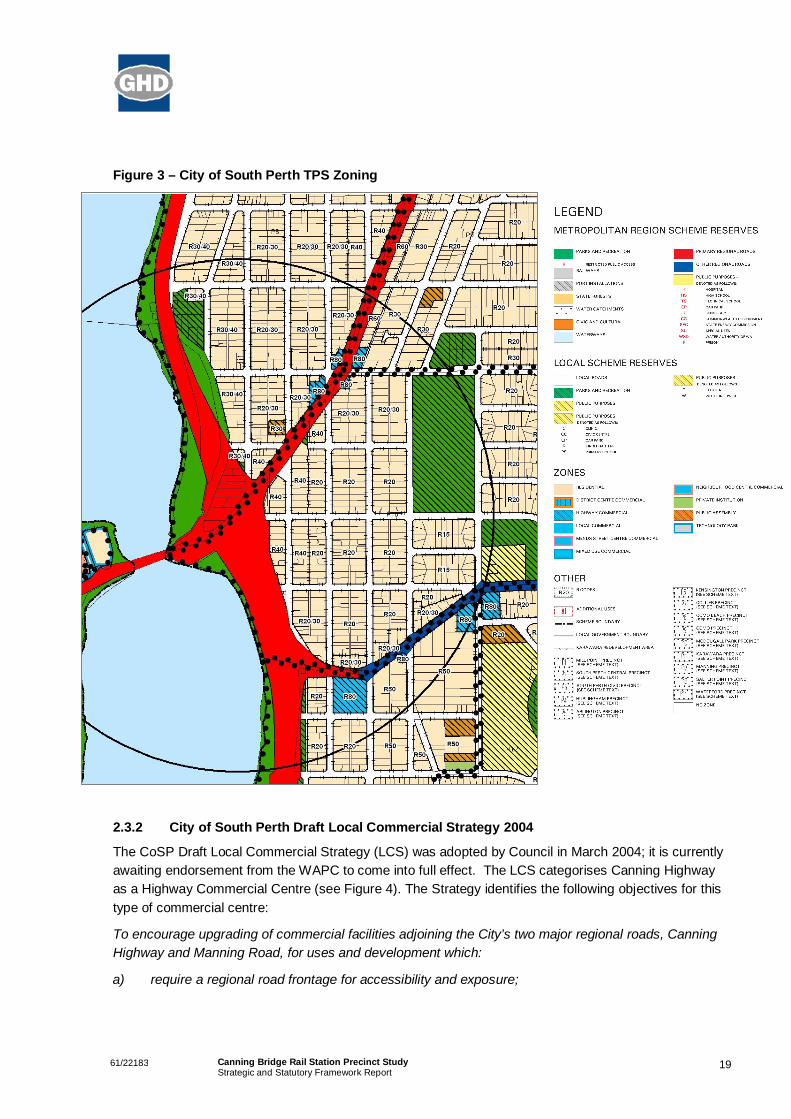
A large portion of the study area located on the CoSP side of the Freeway is zoned ‘Residential’, with aresidential density ranging from ‘R20’ through to ‘R50’ under the CoSP Town Planning Scheme No. 6(TPS6 – see Figure 3).
A majority of the landholdings located adjacent to the train station have previously been developed to aresidential density of R40, with many of the previous quarter acre (~1000m2) properties located in thearea developed as grouped dwellings containing around four new dwellings.
The current densities contained in the CoSP Scheme within the 800m walkable catchment to the stationare significantly lower than those density objectives contained in State policies relating to facilitating TODdevelopments. As such, residential densities within the 800m walkable catchment to the Canning Bridgestation will need to be reviewed as part of this study.
1961/22183 Canning Bridge Rail Station Precinct StudyStrategic and Statutory Framework Report
Figure 3 – City of South Perth TPS Zoning
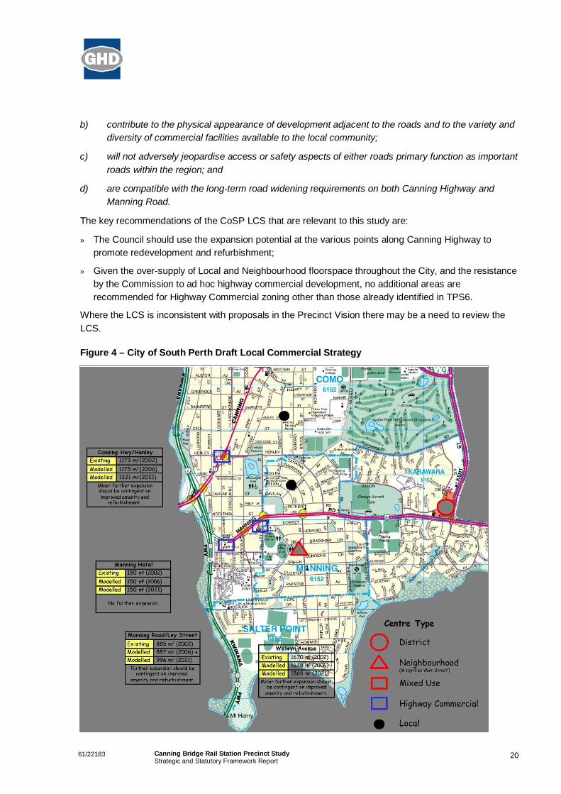
2.3.2 City of South Perth Draft Local Commercial Strategy 2004
The CoSP Draft Local Commercial Strategy (LCS) was adopted by Council in March 2004; it is currentlyawaiting endorsement from the WAPC to come into full effect. The LCS categorises Canning Highwayas a Highway Commercial Centre (see Figure 4). The Strategy identifies the following objectives for thistype of commercial centre:
To encourage upgrading of commercial facilities adjoining the City’s two major regional roads, CanningHighway and Manning Road, for uses and development which:
a) require a regional road frontage for accessibility and exposure;
2061/22183 Canning Bridge Rail Station Precinct StudyStrategic and Statutory Framework Report
b) contribute to the physical appearance of development adjacent to the roads and to the variety anddiversity of commercial facilities available to the local community;
c) will not adversely jeopardise access or safety aspects of either roads primary function as importantroads within the region; and
d) are compatible with the long-term road widening requirements on both Canning Highway andManning Road.
The key recommendations of the CoSP LCS that are relevant to this study are:
» The Council should use the expansion potential at the various points along Canning Highway topromote redevelopment and refurbishment;
» Given the over-supply of Local and Neighbourhood floorspace throughout the City, and the resistanceby the Commission to ad hoc highway commercial development, no additional areas arerecommended for Highway Commercial zoning other than those already identified in TPS6.
Where the LCS is inconsistent with proposals in the Precinct Vision there may be a need to review theLCS.
Figure 4 – City of South Perth Draft Local Commercial Strategy

2161/22183 Canning Bridge Rail Station Precinct StudyStrategic and Statutory Framework Report
2.3.3 City of South Perth Municipal Heritage Inventory
There are a number of properties listed on the CoSP Municipal Heritage Inventory that are located withinthe study area.
One of the key places listed for protection that will have an impact on this study is the Canning Bridgeitself. Canning Bridge is given a Category A classification, which means the bridge is afforded the highestlevel of protection. This classification means that any development/redevelopment of the site requiresconsultation with the City and maximum encouragement should be given to the owner to conserve thesignificance of the place. The inventory also recommends that incentives to promote the conservation ofthe bridge should be considered.
The heritage inventory also recommends that Canning Bridge be included on the State Register ofHeritage Places, which will give legal protection to the site. Since this recommendation, Canning Bridgehas been included on the interim register of Heritage Places (07/09/2006).
2.3.4 City of South Perth Sustainability Strategy Action Plan 2006-2008
The CoSP Sustainability Strategy Action Plan 2006-2008 identifies a number of objectives and targets forthe sustainable governance and development of the City.
The following target/objective is relevant to this study and Precinct:
» Encourage use of public transport and discourage use of vehicles in areas where there is good publictransport. Measures include reassessment of parking zoning in such areas.
2.3.5 Integrated Transport Plan
The CoSP Integrated Transport Plan identifies a number of challenges and opportunities for managinggrowth in demand for transport, land-use planning and implementation. The Plan is a strategic plan forthe City and as such, does not examine individual locations.
The key objectives of the Plan are to:
» Reduce the transport pressure on and within the City;
» Manage the transport corridors and their associated land use environment;
» Preserving and enhancing the village lifestyle;
» Preserving and enhancing the quality of the local environment;
» Improving local accessibility, safety and convenience and increase choice of transport mode;
» Integrating the above strategies into a single Management Plan.
The Integrated Transport Plan contains a number of actions in order to strategically address the transportissues faced by the City and surrounding localities. The following actions are relevant to this study:
» E-1 - Future land-use planning is to encourage better access to and integration between all transportmodes;
» B-9 – Identify opportunities for optimising land use adjacent to transport hubs, as part of ongoing andregular Town Planning Scheme reviews;
» E-2 – Future revisions of the Town Planning Scheme consider the principles identified in the NetworkCity Community Planning Strategy;

2261/22183 Canning Bridge Rail Station Precinct StudyStrategic and Statutory Framework Report
» E-3 – Develop vibrant activity centres within the City;
» E-4 – Consider the principles of the Transit Oriented Development, when designing futuredevelopments in the vicinity of the Canning Bridge and Richardson Park train stations.
2.3.6 City of South Perth Strategic Plan
The CoSP Strategic Plan defines a strategic approach and direction for the CoSP. The Strategic Plandefines the vision for the City as:-
“The City of South Perth will be Perth’s most liveable community – celebrating our history and riversidelocation and creating the opportunities of the future”.
The following strategy goals contained in the Strategic Plan are relevant to this study:
3.3 Ensure future development and current maintenance of the river foreshore, wetlands, lakes,bushlands and parks is properly planned and sustainable and that interaction with the builtenvironment is harmonious and of benefit to the community.
3.5 Ensure the Town Planning Scheme and supporting Policies facilitate the orderly development ofthe City and provides lifestyle options for residents, opportunities for business and an attractiveenvironment for all.
3.6 Develop precinct planning strategies for the Mill Point and Canning Bridge areas to guide futuredevelopment taking into account the Southern Suburbs Railway and the stations planned for theselocations.
4.5 Develop and implement Urban Design Standards to link with the Street Tree Management Planand to encourage consistency of streetscape treatments within defined precincts.
2.3.7 Canning Bridge Train Station Precinct: Community Engagement Report
The purpose of the Canning Bridge Train Station Precinct Community Engagement process was togather input from the CoSP community in order to inform the Precinct planning process for the Precinct.
The methodology for this community engagement exercise included a workshop with CoSP staff,interviews with key stakeholders in the project area, a focus group with randomly selected residents fromthe Mill Street precinct, an open community forum with South Perth residents and community groups anda survey that was sent to 2000 residents.
Interviews were conducted with the following stakeholders identified for the process:
» Aquinas College;
» COM;
» Manning Senior Citizens;
» South Perth Bicycle Users Group;
» CoSP Youth Advisory Committee;
» Curtin University of Technology; and
» TravelSmart/Roadwise Advisory Group.

2361/22183 Canning Bridge Rail Station Precinct StudyStrategic and Statutory Framework Report
In addition to the above consultation, informal meetings were also held with government agencies,including:
» DPI;
» PTA;
» Main Roads WA; and
» Office of Crime Prevention.
The key findings of the engagement exercise include:
» Walking and cycling to the station is perceived to be unsafe, mostly due to the high volumes of trafficand difficulty crossing roads;
» The survey results indicate that pedestrian and cycle safety, as well as the safety of crossing points,are poor or unsatisfactory;
» Survey results also indicate that a moderate amount of people (31% of respondents) will walk to thestation daily or weekly. However, this increases to 48% among those who live within a ten-minutewalk;
» Very few people expect to ride a bicycle regardless of their proximity to the station;
» Residents would like to see improved general access from Como to the foreshore area, with manyseeing the foreshore as a good access point to the station;
» There is support for the Curtin University bus service from focus group discussions, stakeholderinterviews and the community forum. However, the survey results suggest actual residential use maynot be high, with approximately half of those who indicated they would use a bus and train service donot expect to use the proposed Curtin service;
» A range of suggestions to address the problem of access includes above grade solutions (i.e.overpasses), more and better-timed crossing points and the development of transit oriented typedevelopments above the station which are connected to the surrounding residential areas;
» Focus group participants and survey respondents have expressed concern about parking in theprecinct. In particular, there is a concern that passengers will park in residential streets, which willrestrict traffic flow, impact on amenity, and see an increase in crime and antisocial behaviour;
» Focus group participants favoured minimal changes to land uses, preferring to see resources directedtowards improving access;
» Community forum participants suggested a range of land use changes, including a Transit-OrientedDevelopment above the station which would help to better connect the station with surroundingresidential areas;
» Survey respondents were generally supportive of a mix of uses around the station, but were notsupportive of four to five-storey buildings in the immediate vicinity of the station or along CanningHighway;
» There is strong support for the development of meeting places and small scale commercial activityalong the foreshore;
» There is general support for the station and input from the focus groups, interviews and surveysuggests it will be reasonably well used; and
2461/22183 Canning Bridge Rail Station Precinct StudyStrategic and Statutory Framework Report
» Just under half of survey respondents support public art in the precinct, with the main suggestedthemes including river/nature and community themes (including Indigenous art).
2.3.8 City of South Perth Bicycle Plan 2005-2008
The 2005-2008 Bike Plan aims to meet the current and future needs of cyclists by developing andenhancing existing bicycle facilities to improve safety and subsequently encourage cycling within thecommunity.
The CoSP Bicycle Plan identifies a number of existing and proposed bike routes, with a particular focuson northern connections along the river foreshore and connections running east from the Canning BridgePrecinct.
2.3.9 City of South Perth Disability Access and Inclusion Plan 2006-2010
The CoSP Disability Access and Inclusion Plan (2006-2010) identifies a number of strategies to improveaccess and inclusion within the City. The following strategies are relevant to this study area:
» Support the development of services to meet the needs of people with disabilities, their families andcarers;
» Ensure that all new or redevelopment works provide access to people with disabilities, wherepracticable;
» Ensure all infrastructure related to transport facilities is accessible;
» Ensure the accessibility of streetscapes;
» Ensure that parks, reserves and foreshores are accessible.
The recommendation and key actions of this study will need to consider access for people withdisabilities.
2561/22183 Canning Bridge Rail Station Precinct StudyStrategic and Statutory Framework Report
3. References
Belingwe Pty Ltd & Planwest (WA) Pty Ltd. 2006, City of Melville Local Commercial Strategy,
City of Melville. Sustainable Residential Design Guidelines, Available from:<http://www.melvillecity.com.au/environment/ecological-sustainability>
City of Melville. Sustainable Residential Design Policy, Available from:<http://www.melvillecity.com.au/environment/ecological-sustainability>
City of Melville. 2006, Policy Manual – Canning Highway, Available from:<http://www.melvillecity.com.au/about/corporate-information-documents/policies>
City of Melville. 2006, Policy Manual – Mixed-Use Development, Available from:<http://www.melvillecity.com.au/about/corporate-information-documents/policies>
City of Melville. 2007, People, Places, Participation: A Community Plan for the City of Melville 2007-2017
City of Melville, Community Planning Scheme Amendment No. 35, Available from the City of Melville,Unpublished
City of Melville (2008) Draft Local Planning Strategy 2008 – 2023 Available from:http://www.melvillecity.com.au/our-future/local-planning-strategy
City of Melville, City of Melville Transport Strategy, Available from the City of Melville, Unpublished.
City of Melville, Canning Bridge Precinct Traffic Study, Available from the City of Melville, Unpublished
City of South Perth (2004), Draft Local Commercial Strategy 2004, Available from the City of SouthPerth, Unpublished, http://www.southperth.wa.gov.au/ .
City of South Perth (2005) Municipal Heritage Inventory, Available from the City of South Perth,Unpublished. http://www.southperth.wa.gov.au/
City of South Perth (2006), Sustainability Strategy Action Plan 2006-2008, Available from the City ofSouth Perth http://www.southperth.wa.gov.au/city_sustainability/city_sustainability_strat_action.htm
City of South Perth (2005), Draft Integrated Transport Plan, Available from the City of South Perthhttp://www.southperth.wa.gov.au/out_for_comment/old_out_for_comment/integratedtransportplan.pdf
City of South Perth, City of South Perth Strategic Plan Available from the City of South Perth,Unpublished. http://www.southperth.wa.gov.au/
City of South Perth, Canning Bridge Train Station Precinct: Community Engagement Report, Availablefrom the City of South Perthhttp://www.southperth.wa.gov.au/out_for_comment/old_out_for_comment/20070718_south_perth_report_v2.doc
City of South Perth, (2005), Bicycle Plan 2005-2008, Available from the City of South Perthhttp://www.southperth.wa.gov.au/out_for_comment/old_out_for_comment/bikeplan20052008.pdf
City of South Perth (2006), Disability Access and Inclusion Plan 2006-2010, Available from the City ofSouth Perth http://www.southperth.wa.gov.au/disability_services/disability_plan.pdf
2661/22183 Canning Bridge Rail Station Precinct StudyStrategic and Statutory Framework Report
Department for Planning & Infrastructure. (2003), Dialogue with the City: Working together to make Perththe world’s most liveable city
PPK Environment & Infrastructure. 2000, City of Melville Transport Strategy
Sinclair Knight Merz. 2003, Integrated Regional Plan for South West Metropolitan Perth, prepared by BEmerson & E Richardson, 16 April 2003.
Western Australian Planning Commission. (2009) Directions 2031 Draft Spatial Framework for Perth andPeel, Perth
Western Australian Planning Commission. (2009) Draft State Planning Policy Activity Centres for Perthand Peel, Perth
Western Australian Planning Commission. (2006), State Planning Policy 2.10 – Swan-Canning RiverSystem, gazetted 19 December 2006, Perth
Western Australian Planning Commission. (2005), Designing Out Crime: Planning Guidelines Outline
Western Australian Planning Commission. (2004), Liveable Neighbourhoods
Western Australian Planning Commission. (2004), Network City: Community Planning Strategy for Perthand Peel
Western Australian Planning Commission. (2000), State Planning Policy 4.2 – Metropolitan CentresPolicy, gazetted 17 October 2000
Western Australian Planning Commission. (1999), City of Melville Community Planning Scheme No. 5,gazetted 14 December 1999
Western Australian Planning Commission (2003) City of South Perth Town Planning Scheme No. 6,gazetted 29 April 2003
2761/22183 Canning Bridge Rail Station Precinct StudyStrategic and Statutory Framework Report
Appendix A
Draft State Planning Policy 3.6 – DeveloperContributions for Infrastructure

State Planning Policy 3.6Development Contributions
for Infrastructure
M a y 2 0 0 8
Draft
Prepared under part 3 of thePlanning and Development Act 2005
by the Western Australian Planning Commission
© State of Western Australia
Published by theWestern Australian Planning Commission
Albert Facey House469 Wellington Street
Perth, Western Australia 6000
Published April 2008
website: www.wapc.wa.gov.auemail: [email protected]
tel: (08) 9264 7777fax: (08) 9264 7566TTY: (08) 9264 7535infoline:1800 626 477
Copies of this document are available in alternative formats onapplication to the disability services coordinator
Disclaimer
This document is a draft and has been approved by the Western AustralianPlanning Commission for the purposes of advertising only. Any representation,statement, opinion or advice expressed or implied in this publication is made ingood faith and on the basis that the government, its employees and agents are
not liable for any damage or loss whatsoever which may occur as a result ofaction taken or not taken (as the case may be) in respect of such representation,
statement, opinion or advice referred to in this draft document.
State Planning Policy 3.6Development Contributions
for Infrastructure(Draft)
Prepared under part 3 of thePlanning and Development Act 2005
by the Western Australian Planning Commission
Albert Facey House469 Wellington Street
Perth, Western Australia 6000
May 2008
State Planning Policy Development Contributions for InfrastructureDraft
Contents
1 Citation 1
2 Introduction and background 1
3 Application of policy 3
4 Objectives of the policy 3
5 Policy measures 3
5.1 Scope 3
5.2 Principles underlying development contributions 3
5.3 Imposition of development contributions 4
5.4 Characteristics of a development contribution plan 5
5.5 Process for determining development contributions for community infrastructure 5
5.6 Form of contributions 6
5.7 Development contributions as conditions of rezoning 6
5.8 The application of a credit in a development contribution plan 6
6 Implementation 7
Appendix 1 Standard development contribution requirements 9
Appendix 2 Model text provisions for development contributions 10
Appendix 3 Methodology for developing community infrastructuredevelopment contribution plans 18
State Planning Policy Development Contributions for InfrastructureDraft
1
1 CitationThis state planning policy is made under section 26 of the Planning and Development Act 2005. Thispolicy can be cited as State Planning Policy 3.6 Development Contributions for Infrastructure
2 Introduction and backgroundThis policy sets out the principles and considerations that apply to development contributions for theprovision of infrastructure in new and established urban areas.
The careful planning and coordination of infrastructure is fundamental to the economic and social well-being of any community. New urban developments and redevelopments must ensure the cost-efficientprovision of infrastructure and facilities such as roads, public transport, water supply, sewerage,electricity, gas, telecommunications, drainage, open space, schools, health, community and recreationfacilities. All of these utilities and services greatly influence the standard of living, mobility and lifestylechoices of a community.
Public infrastructure is funded through various sources including state government taxes, localgovernment property rates, federal assistance grants, user and access charges, fees and charges,and development contributions. In Western Australia, development contributions for infrastructure havelong been accepted as an essential part of the planning system. Land developers are responsible forthe provision of physical infrastructure including water supply, sewerage and drainage, roads andpower and for some community infrastructure including public open space and primary school siteswhich are necessary for the development. The scope of such contributions is defined in a WesternAustralian Planning Commission (WAPC) policy adopted in 1997 which is set out in Planning Bulletin18 Developer Contributions for Infrastructure.
Development contributions are usually by way of land, works or payments towards the provision ofinfrastructure. Requirements for development contributions are imposed by way of conditions onsubdivision; or, in areas of fragmented ownership where cost-sharing arrangements are necessary, bydevelopment schemes or development contribution arrangements made under local governmentschemes. The WAPC adopted draft model provisions for local government schemes in 2000 which areset out in Planning Bulletin 41 Draft Model Text Provisions for Development Contributions.
In Western Australia, as in other Australian states, local governments face increasing pressures on theservices they provide. These pressures arise from population and economic growth and increasingexpectations of the community for new and upgraded infrastructure.
Examples of these pressures are:
• Greenfield development of rural land for urban purposes, where there are standard requirementsfor infrastructure and facilities which are imposed, by the WAPC as conditions on the subdivisionof the land, but where local governments may require infrastructure or facilities over and abovethe common standards.
• Infill development and redevelopment where common standard conditions of subdivision stillapply, but where significant changes in the type or intensity of land use may require newinfrastructure and facilities or the augmentation of existing infrastructure and facilities beyond thenormal scope of standard subdivision conditions.
The capacity of local governments to provide the additional infrastructure and facilities necessary toaccommodate future growth and change is limited by the available financial resources. As a result,

State Planning Policy Development Contributions for InfrastructureDraft
2
local governments are increasingly seeking to apply development contributions for the provision ofinfrastructure and facilities such as local roads, car parking, community centres, recreation centres,sporting facilities, libraries, child care centres, public open space and other such facilities.
Local governments have indicated that they need more guidance on the scope and framework fordevelopment contributions of this nature. The development industry has also pointed to the need forgreater consistency and transparency in charging developers because of the potential impacts onhousing affordability and to avoid inequities arising from new residents subsidising existing residents.
This policy follows a joint study into development contributions undertaken by the Urban DevelopmentInstitute of Australia (UDIA), Western Australia Local Government Association (WALGA), and theDepartment for Planning and Infrastructure (DPI). It replaces Planning Bulletin 18 and sets out thestandard development contributions for infrastructure applied by the WAPC on the subdivision of land.It also provides a consistent, accountable and transparent system for local governments to plan andcharge for development contributions over and above the standard provisions through developmentcontribution plans.
The policy has taken into account the recommendations of the Public Accounts Committee - Inquiryinto Developer Contributions for Costs Associated with Land Development (2004). The inquiry, amongother things, recommended that local governments should have the capacity to recoup infrastructurecosts and that this should be by way of provisions in local planning schemes. Under this policy, localgovernment planning schemes will set out the system of charging through development contributionplans. The policy provides an equitable system for planning and charging development contributions,and provides certainty to developers, infrastructure providers and the community about the chargeswhich apply and how the funds will be spent.
The key principle is that the 'beneficiary' pays. Sometimes benefits will be largely confined to theresidents of a new development. Sometimes the benefits will accrue to existing as well as newresidents. Consistent with this principle, new residents will fund only the infrastructure and facilitieswhich are reasonable and necessary for the development and to the extent that they derive the benefitfrom the infrastructure and facilities. Therefore, development contribution plans will need to identifygrowth trends based on service catchment areas, translate these trends into the infrastructure andfacilities necessary to meet these increasing needs within the catchment, and allocate the costs ofmeeting these needs to existing residents and new residents proportional to their contribution to theneed for the infrastructure and facilities. This policy will ensure fairness and equity. It will mean thatexisting and new residents will share the cost burden of additional infrastructure and facilitiesproportional to their need.
A fundamental prerequisite of development contribution plans is that local governments will need toplan ahead. The development contribution plan must have a strategic basis and be linked to the localplanning strategy and strategic infrastructure plan and program which identify the infrastructure andfacilities required over the next 5-10 years and the cost and revenue sources for the provision of theinfrastructure. In this way, those contributing towards the development contribution plan will be assuredthat the funds will contribute to the local government's longer-term planning and programming ofinfrastructure in an integrated and coordinated way.
This policy set out the principles underlying development contributions and the form, content andprocess for the preparation of a development contribution plan under a local planning scheme. It alsoincludes the WAPC standard requirements for development contributions (appendix 1), modeldevelopment contribution plan provisions (appendix 2) and a template for a local government strategicinfrastructure plan and program.
State Planning Policy Development Contributions for InfrastructureDraft
3
3 Application of policyThe policy applies throughout Western Australia.
4 Objectives of the policyThe objectives of this policy are:
• To promote the efficient and effective provision of public infrastructure and facilities to meet thedemands arising from new growth and development.
• To ensure that development contributions are necessary and relevant to the development to bepermitted and are charged equitably among those benefiting from the infrastructure and facilitiesto be provided.
• To ensure consistency and transparency in the system for apportioning, collecting and spendingdevelopment contributions.
5 Policy measures5.1 Scope
Development contributions can be sought for items of infrastructure that are required to support theorderly development of an area. These items include the standard requirements for infrastructurecontributions as outlined in appendix 1. In addition, local governments can seek contributions forcommunity infrastructure which is defined as:
'the structures, systems and capacities which help communities and neighbourhoods to functioneffectively.'
Development contributions can be sought for:
• a new item of infrastructure;• land for infrastructure;• an upgrade in the standard of provision of an existing item of infrastructure;• an extension to existing infrastructure;• the total replacement of infrastructure once it has reached the end of its economic life; and• other costs reasonably associated with the preparation, implementation and administration of a
development contribution plan.
5.2 Principles underlying development contributions
Development contributions must be levied in accordance with the following principles:
1 Need and the nexusThe need for the infrastructure included in the development contribution plan must be clearlydemonstrated (need) and the connection between the development and the demand createdshould be clearly established (nexus).
2 TransparencyBoth the method for calculating the development contribution and the manner in which it isapplied should be clear, transparent and simple to understand and administer.
3 EquityDevelopment contributions should be levied from all developments in a development contributionarea, based on their relative contribution to need.
State Planning Policy Development Contributions for InfrastructureDraft
4
4 CertaintyAll development contributions should be clearly identified and methods of accounting forescalation agreed on at the commencement of a development.
5 EfficiencyDevelopment contributions should be justified on a whole-of-life capital cost basis consistent withmaintaining financial discipline on service providers by precluding over-recovery of costs.
6 ConsistencyDevelopment contributions should be applied uniformly across a development contribution areaand the methodology for applying contributions should be consistent.
7 Right of consultation and reviewDevelopers have the right to be consulted on the manner in which development contributions aredetermined. They also have the opportunity to seek a review by an independent third party ifthey believe the contributions are not reasonable.
8 AccountableThere must be accountability in the manner in which development contributions are determinedand expended.
5.3 Imposition of development contributions
Development contributions may relate to the requirements of utility providers (water,telecommunications, gas or electricity), state government requirements and the requirements of localgovernment.
Where local governments are seeking development contributions beyond the standard provisionsoutlined in appendix 1, they must be supported by a development contribution plan for the relevantdevelopment contribution area or by a voluntary agreement between a developer and the relevant localgovernment. This need may not arise where there is one development and the need for thedevelopment condition is created by that development. The condition(s) must be consistent with theprinciples outlined in section 5.2.
There are three stages to the imposition of development contributions.
5.3.1 Development contributions are formulated and agreed.The development contribution plan is used to prescribe the cost contributions for owners in adevelopment contribution area.. This would normally be undertaken through the developmentof planning schemes and planning scheme amendments as detailed in section 5.5.
5.3.2 Development contributions are calculated and applied.Development contributions are generally calculated and applied by way of a condition ofsubdivision particularly in greenfield areas. Development contributions may also be sought inmajor infill and redevelopment areas at the time of development.
They may be calculated and applied as:
• standard conditions of subdivision;• conditions of development; and• legal/voluntary agreements.

This applies to subdivisional works such as roads, drainage and the provision of power,water and telecommunications as outlined in appendix 1. They may also be applied asconditions of development. The calculation will be to apply the detail of the developercontribution scheme to the development including any offsets for the ceding of land orconstruction of infrastructure.
5.3.3 Development contributions become due and payable.Development contributions become due and payable as part of the clearance process.Clearance for the issuance of titles should not occur until full payment, as calculated andapplied, has been finalised.
5.4 Characteristics of a development contribution plan
Development contribution plans require that:
• there is a clear and sound basis with linkages to the local government’s strategic and financialplanning processes;
• there is justification for the infrastructure identified in the development contribution plan;• the costs of infrastructure are appropriate;• there is a commitment to providing the infrastructure in a reasonable period;• the development contribution area to which the development contribution plan applies is
appropriate;• cost-sharing arrangements between owners in the development contribution area are fair and
reasonable; and• there is consultation with the owners affected by the development contribution plan.
Development contribution plans prescribe the cost contributions for owners in a developmentcontribution area. The focus of development contributions is on the provision of capital items. The costsassociated with design and construction of infrastructure (including land costs), and the cost ofadministration should be included in the development contribution plan.
A development contribution plan does not have effect until it is incorporated into a local planningscheme. As it forms part of the scheme, the Town Planning Regulation 1967, including advertisingprocedures and the requirement for ministerial approval, will apply to the making or amendment of adevelopment contribution plan.
A development contribution plan is to be prepared for a development contribution area . Thedevelopment contribution area must be identified on the scheme map. Model Scheme Text provisionsfor development contributions can be found at appendix 2. Development contribution plans areincorporated into schemes via special control areas.
Local governments may also enter into voluntary arrangements with developers for contributions forthe provision of community infrastructure. Such agreements should reflect the principles outlined insection 5.2.
5.5 Process for determining development contributions for community infrastructure
Local government requirements for development contributions for community infrastructure should becalculated on the basis of:
• the need for that infrastructure based on an analysis of the demand;
State Planning Policy Development Contributions for InfrastructureDraft
5
State Planning Policy Development Contributions for InfrastructureDraft
• the nexus where the relationship between the need for infrastructure and the new developmentis clearly established;
• catchment areas that the infrastructure would service identifying both existing demand andnew demand that is associated with the development; and
• the cost of providing the infrastructure which should be based on the latest or best estimatesavailable to the local government and should include provision for regular adjustments toaccount for cost escalation over time.
Where a local government is seeking contributions for community infrastructure, these need to besupported by:
• A community infrastructure plan for the area, identifying the services and facilities requiredover the next 5-10 years (supported by demand analysis and identification of servicecatchments).
• A capital expenditure plan (with at least five out years) which identifies the capital costs offacilities and the revenue sources (including capital grants) and programs for provision.
• Projected growth figures including the number of new dwellings to be created at catchmentlevel (suburb or district).
• A methodology for determining the proportion of costs of community infrastructure to beattributed to growth and the proportion to be attributed to existing areas.
The process for determining development contributions for community infrastructure is outlined atappendix 3.
5.6 Form of contributions
Conditions relating to development contribution requirements can be satisfied by:
• the ceding of land for roads, public open space, primary school sites, drainage and otherreserves;
• construction of infrastructure works which are transferred to public authorities on completion;• monetary contributions to acquire land or undertake works by public authorities or others; or• a combination of the above.
5.7 Development contributions as conditions of rezoning
Local governments are not to impose development contributions beyond the scope of WAPC policy asconditions or prerequisites for rezoning. The rezoning process is not to be used to imposeunreasonable demands on land development outside the scope of WAPC policy.
Development contributions must be open and appealable, and should be implemented through theprocess specified in section 5.3, or through development contribution plans or voluntary agreementsthat are transparent and follow the due planning process.
5.8 The application of a credit in a development contribution plan
A development contribution plan may identify infrastructure that:
• needs to be actioned with the first development in a development contribution area such as amajor road extension/connection; and
• is predominantly located on the developer’s land such as major playing fields to service thelarger development contribution area.
6
The local government may mandate that this work is undertaken creating an in-kind contributionbeyond that identified in the development contribution plan for that area. In this instance the developerand the local government must negotiate a fair and reasonable outcome in relation to this credit.Appropriate negotiated outcomes may include:
• Where a developer has other land holdings in the area that, the credit is held until it is requiredto be used by the developer to offset future contributions.
• Where a developer has no further holdings in the area, the amount is held as a credit to thedeveloper until payments into the development contribution plan are received from subsequentdevelopers. The credit is then reimbursed to the developer.
• Where the development contribution plan is in credit from developer contributions alreadyreceived, the credit should be reimbursed on completion of the works/ceding of land.
Any indexing of the developer contribution scheme should be equally applied to credits.
6 ImplementationImplementation of this policy will primarily be through local planning strategies, structure plans andlocal planning schemes and the day-to-day consideration of zoning, subdivision, strata subdivision anddevelopment proposals and applications, together with the actions and advice of agencies in carryingout their responsibilities.
State Planning Policy Development Contributions for InfrastructureDraft
7

State Planning Policy Development Contributions for InfrastructureDraft
9
Appendix 1 Standard development contribution requirements
Land contributions
Public open spacePublic open space equivalent to10 per cent of the grosssubdivisional area, oralternatively, a cash-in-lieucontribution subject toagreementbetween the developer, WAPCand local government.
Foreshore reservesCertain land for foreshorereserves on the coast, riversand lakes in accordance withWAPC policies.
Primary schoolsLand for government primaryschools.
RoadsLand for widening existing roadswhere the subdivision inducesadditional traffic movements.
Land for district distributor roadsin new development areas thatexpand the urban front.
Land for primary distributorroads and railway reserveswhere justified by thesubdivision.
Other contributions as providedfor in WAPC policies.
Infrastructure works
UtilitiesReticulation of:• water• sewerage• drainage works• electricity supply
infrastructure• telecommunications
This covers on-site works aswell as off-site capital workssuch as major pump stations,trunk sewers or transmissionlines that are necessary to, orcontribute to, the subdivision.Note that these works are inaddition to monetary charges bythe Water Corporation andWestern Power for off-site majorinfrastructure.
RoadsAll roads and traffic worksrequired within the subdivisionand linked to a constructedpublic road. These roads provideaccess to individual lots andallow utility services to bereticulated in the road reserves.
Footpaths, pedestrian accessways and dual-use paths whererequired (generally along oneside of a road).
Upgrading, construction andwidening of existing roads andrights-of-way to accommodateadditional traffic generated by asubdivision.
New district distributor roadsincluding earthworks for thewhole road reserve, theconstruction of one carriagewaycomprised of two lanes andassociated drainage works. Inaddition, where set out in astructure plan for the area,grade-separated pedestriancrossings and dual-use pathsmay be required as acontribution.
Monetary contributions
Standard water, sewerage anddrainage headworks charges foroff-site major infrastructureworks.
If an area is in fragmentedownership, monetarycontributions can be required inlieu of land or infrastructureworks, and to reimburse otherowners where costs are shared.
State Planning Policy Development Contributions for InfrastructureDraft
Appendix 2 Model text provisions for development contributions6.1 Operation of special control areas
6.1.1 The following special control areas are shown on the scheme map:
(a) development areas shown on the scheme map as DA with a number and included inschedule XX; and
(b) development contribution areas shown on the scheme map as DCA with a number andincluded in schedule YY.
6.1.2 In respect of a special control area shown on a scheme map, the provisions applying to thespecial control area apply in addition to the provisions applying to any underlying zone orreserve and any general provisions of the scheme.
6.2 Development areas
For clause 6.2 regarding development areas see planning bulletin 37 (February 2000) attachment 1.
6.3 Development contribution areas
6.3.1 Interpretation
In clause 6.3, unless the context otherwise requires:
‘Administrative costs’ means such costs as are reasonably incurred for the preparation andimplementation of the development contribution plan.
‘Cost apportionment schedule’ means a schedule prepared and distributed in accordancewith clause 6.3.10.
‘Cost contribution’ means the contribution to the cost of infrastructure and administrativecosts.
‘Infrastructure’ means services and facilities which, in accordance with the WAPC's policy, itis reasonable for owners to contribute towards.
‘Owner’ means an owner of land that is located within a development contribution area.
6.3.2 Purpose
The purpose of having development contribution areas is to:
(a) provide for the equitable sharing of the costs of infrastructure and administrative costsbetween owners;
(b) ensure that cost contributions are reasonably required as a result of the subdivision anddevelopment of land in the development contribution area; and
(c) coordinate the timely provision of infrastructure.
10
6.3.3 Development contribution plan required
A development contribution plan is required to be prepared for each developmentcontribution area.
6.3.4 Development contribution plan part of scheme
The development contribution plan does not have effect until it has been incorporated inschedule ZZ as part of the scheme.
6.3.5 Subdivision and development
6.3.5.1 Where a development contribution plan is in effect, the local government shall not:
(a) consider or recommend subdivision; or
(b) development of land within a development contribution area until;
(c) a development contribution plan is in effect; or
(d) the owner who has applied for subdivision or development approval has madearrangements in accordance with clause 6.3.14 for the payment of the owner’s costcontribution.
6.3.5.2 Where a development contribution plan is not in effect, the local government maysupport subdivision or approve development where the owner has made otherarrangements satisfactory to the local government with respect to the owner’scontribution towards the provision of infrastructure and administrative costs in thedevelopment contribution area.
Comments
A development contribution plan is only enforceable once it is incorporated into the scheme.This has two major implications:
• All advertising and other provisions under the Town Planning Regulations 1967applicable to the making of schemes and amendments will apply.
• Any amendment to a development contribution plan will require a scheme amendment inorder to become enforceable.
6.3.6 Guiding principles for development contribution plans
The development contribution plan for any development contribution area is to be preparedin accordance with the following principles:
(a) Need and the nexusThe need for the infrastructure included in the development contribution plan must beclearly demonstrated (need) and the connection between the development and thedemand created should be clearly established (nexus).
State Planning Policy Development Contributions for InfrastructureDraft
11
State Planning Policy Development Contributions for InfrastructureDraft
(b) TransparencyBoth the method for calculating the development contribution and the manner in which it
is applied should be clear, transparent and simple to understand and administer.
(c) EquityDevelopment contributions should be levied from all developments in a developmentcontribution area, based on their relative contribution to need.
(d) CertaintyAll development contributions should be clearly identified and methods of accounting forescalation agreed on at the commencement of a development.
(e) EfficiencyDevelopment contributions should be justified on a whole-of-life capital cost basisconsistent with maintaining financial discipline on service providers by precluding over-recovery of costs.
(f) ConsistencyDevelopment contributions should be applied uniformly across a developmentcontribution area and the methodology for applying contributions should be consistent.
(g) Right of consultation and reviewDevelopers have the right to be consulted on the manner in which developmentcontributions are determined. They also have the opportunity to seek a review by anindependent third party if they believe the contributions are not reasonable.
(h) AccountableThere must be accountability in the manner in which development contributions aredetermined and expended.
Comments
Apportionment of infrastructure costs based on area assumes that the land concerned hasfairly common characteristics. Therefore, development contribution areas should beidentified, as far as possible, with common characteristics so that cost contributions reflectfuture development potential. Where it is not possible to identify land with fairly commoncharacteristics, consideration may be given to apportioning infrastructure costs based onland valuation.
6.3.7 Recommended content of development contribution plans
6.3.7.1 The development contribution plan is to specify:
(a) the development contribution area to which the development contribution plan applies;
(b) the infrastructure and administrative costs to be funded through the developmentcontribution plan;
(c) the method of determining the cost contribution of each owner; and
(d) the priority and timing for the provision of infrastructure.
12

State Planning Policy Development Contributions for InfrastructureDraft
13
Comments
A suggested outline of a development contribution plan is contained in schedule ZZ.
6.3.8 Period of development contribution plan
A development contribution plan may specify the period during which it is to operate.
Comments
A development contribution plan may specify the period during which it is to operate.However, any extension of the period of operation of a development contribution planrequires a scheme amendment which will, in turn, require the approval of the Minister. Therecommended maximum period is five years (to coincide with the scheme review) but, alonger or shorter period may be appropriate depending on the particular circumstances ofthe development contribution area (eg size of the development contribution area, number ofowners and nature of the infrastructure to be funded).
6.3.9 Land excluded
In calculating both the area of an owner’s land and the total area of land in a developmentcontribution area, the area of land provided in that development contribution area for:
(a) roads designated under the _________ Region Scheme as primary regional roads andother regional roads;
(b) existing public open space;
(c) government primary and secondary schools; and
(d) such other land as is set out in the development contribution plan,
is to be excluded.
6.3.10 Development contribution plan report and cost apportionment schedule
6.3.10.1 Within 90 days of the gazettal date of the development contribution plan, the localgovernment is to make available a development contribution plan report and costapportionment schedule to all owners in the development contribution area.
6.3.10.2 The development contribution plan report and the cost apportionment scheduleshall set out in detail the calculation of the cost contribution for each owner in thedevelopment contribution area based on the methodology provided in thedevelopment contribution plan.
6.3.10.3 The development contribution plan report and the cost apportionment schedule donot form part of the scheme.
Comment
A suggested outline of a cost apportionment schedule is attached at the appendix. The costapportionment schedule is adopted by the local government but does not form part of thescheme.

State Planning Policy Development Contributions for InfrastructureDraft
14
6.3.11 Cost contributions based on estimates
6.3.11.1 The value of infrastructure and administrative costs is to be based on amountsexpended, but when expenditure has not occurred, it is to be based on the bestand latest estimated costs available to the local government.
6.3.11.2 Where a cost apportionment schedule contains estimated costs, such estimatedcosts are to be reviewed at least annually by the local government:
(a) in the case of land to be acquired, in accordance with clause 6.3.12; or
(b) in all other cases, in accordance with the best and latest informationavailable to the local government,
until the expenditure on the relevant item of infrastructure or administrative costshas occurred.
6.3.11.3 The local government is to have such estimated costs independently certified by anappropriate qualified person and must provide such independent certification to anowner where requested to do so.
6.3.11.4 Where any cost contribution has been calculated on the basis of an estimated cost,the local government:
(a) is to adjust the cost contribution of any owner in accordance with therevised estimated costs; and
(b) may accept a cost contribution, based on estimated costs, as a final costcontribution and enter into an agreement with the owner accordingly.
6.3.11.5 Where an owner’s cost contribution is adjusted under clause 6.3.11.4, the localgovernment, on receiving a request in writing from an owner, is to provide theowner with a copy of estimated costs and the calculation of adjustments.
6.3.12 Valuation
6.3.12.1 Clause 6.3.12 applies in order to determine the value of land to be acquired for thepurpose of providing infrastructure.
6.3.12.2 In clause 6.3.12:
‘Value’ means fair net expectance value which is to be calculated by:
(a) determining the highest and best use of the land in its englobo state, eitheron its own or with other land ripe for subdivision; and
(b) adding the margin for profit foregone had the land been able to besubdivided in its optimum form including allowances for all usual costs andexpenses attributed to that land required to carry out such an exercise,,
but not including an allowance for risk as might otherwise have beenmade.
‘Profit’ is to be 10 per cent calculated by the difference between:
(a) the gross realisation of the lots or part lots yielded from the subjectland less the advertising and legal expenses so required to sell thelots; and
(b) the amount of (a) divided by 1.1.
‘Valuer’ means a licensed valuer agreed by the local government and theowner, or where the local government and the owner are unable to reachagreement, a valuer appointed by the President of the Western AustralianDivision of the Australian Property Institute.
6.3.12.3 If an owner objects to a valuation made by the valuer, the owner may give notice tothe local government requesting a review of the amount of the value, at theowner’s expense, within 28 days after being informed of the value.
6.3.12.4 If the valuer does not change the value of the land to a figure acceptable to theowner, the value is to be determined:
(a) by any method agreed between the local government and the owner; or
(b) if the local government and the owner cannot agree, by arbitration inaccordance with the Commercial Arbitration Act 1985.
6.3.13 Liability for cost contributions
6.3.13.1 An owner is required to make a cost contribution in accordance with the applicabledevelopment contribution plan and the provisions of clause 6.3.
6.3.13.2 An owner’s liability to pay the owner’s cost contribution to the local governmentarises on the earlier of:
(a) the WAPC endorsing its approval on the diagram or plan of survey of thesubdivision of the owner’s land within the development contribution area;
(b) the commencement of any development on the owner’s land within thedevelopment contribution area;
(c) the time of applying to the local government or WAPC for approval of anydevelopment on the owner’s land within the development contribution areaor;
(d) at the expiry of the development contribution plan in accordance withclause 6.3.8.
6.3.13.3 Notwithstanding clause 6.3.13.2, an owner’s liability to pay the owner’s costcontribution does not arise if the owner commences development of the first singlehouse or outbuildings associated with that first single house on an existing lotwhich has not been subdivided since the gazettal of the development contributionplan.
State Planning Policy Development Contributions for InfrastructureDraft
15
State Planning Policy Development Contributions for InfrastructureDraft
Comments
The local government may wish to give consideration to other forms of development, of aminor or incidental nature, that should be excluded for the purpose of triggering liabilityunder clause 6.3.13 eg the erection of a boundary fence.
6.3.14 Payment of cost contribution
6.3.14.1 The owner, with the agreement of the local government, is to pay the owner’s costcontribution by:
(a) cheque or cash;
(b) transferring to the local government or a public authority land in satisfactionof the cost contribution;
(c) some other method acceptable to the local government; or
(d) any combination of these methods.
6.3.14.2 The owner, with the agreement of the local government, may pay the owner’s costcontribution in a lump sum, by installments or in such other manner acceptable tothe local government.
6.3.14.3 Payment by an owner of the cost contribution, including a cost contribution basedon estimated costs, constitutes full and final discharge of the owner’s liability underthe development contribution plan.
6.3.15 Charge on land
6.3.15.1 The amount of any cost contribution for which an owner is liable under clause6.3.13, but has not paid, is a charge on the owner’s land to which the costcontribution relates, and the local government may lodge a caveat, at the owner’sexpense, against the owner’s title to that land.
6.3.15.2 The local government, at the owner’s expense and subject to such other conditionsas the local government thinks fit, is to withdraw a caveat lodged under clause
6.3.15.1 To permit a dealing and may then re-lodge the caveat to prevent further dealings.
6.3.15.3 If the cost contribution is paid in full, and if requested to do so by the owner, thelocal government, at the expense of the owner, is to withdraw any caveat lodged
under clause 6.3.15.
6.3.16 Administration of funds
6.3.16.1 The local government is to establish and maintain a reserve account in accordancewith the Local Government Act 1995 for each development contribution area intowhich cost contributions for that development contribution area will be credited andfrom which all payments for the cost of infrastructure and administrative costswithin that development contribution area will be paid. The purpose of such a
16
reserve account or the use of money in such a reserve account is limited to theapplication of funds for that development contribution area.
6.3.16.2 Interest earned on cost contributions credited to a reserve account in accordancewith clause 6.3.16.1 is to be applied in the development contribution area to whichthe reserve account relates.
6.3.16.3 The local government is to publish an audited annual statement of accounts forthat development contribution area as soon as practicable after the audited annualstatement of accounts becomes available.
6.3.17 Shortfall or excess in cost contributions
6.3.17.1 If there is a shortfall in the total of cost contributions when all cost contributionshave been made or accounted for in a particular development contribution area,the local government may:
(a) make good the shortfall;
(b) enter into agreements with owners to fund the shortfall; or
(c) raise loans or borrow from a financial institution.
but nothing in paragraph 6.3.17.1(a) restricts the right or power of the localgovernment to impose a differential rate to a specified development contributionarea in that regard.
6.3.17.2 If there is an excess in funds available to the development contribution area whenall cost contributions have been made or accounted for in a particular development
contribution area, the local government is to apply the excess funds for theprovision of additional facilities or improvements in that development contributionarea.
6.3.18 Powers of the local government
The local government in implementing the development contribution plan has the power to:
(a) acquire any land or buildings within the scheme area under the provisions of thePlanning and Development Act 2005; and
(b) deal with or dispose of any land which it has acquired under the provisions of thePlanning and Development Act 2005 in accordance with the law and for such purposemay make such agreements with other owners as it considers fit.
6.3.19 Arbitration
Subject to clause 6.3.12.4, any dispute between an owner and the local government inconnection with the cost contribution required to be made by an owner is to be resolved byarbitration in accordance with the Commercial Arbitration Act 1985.
State Planning Policy Development Contributions for InfrastructureDraft
17
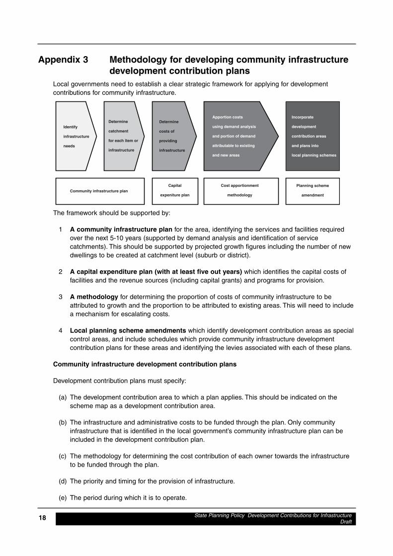
State Planning Policy Development Contributions for InfrastructureDraft
18
Appendix 3 Methodology for developing community infrastructuredevelopment contribution plans
Local governments need to establish a clear strategic framework for applying for developmentcontributions for community infrastructure.
The framework should be supported by:
1 A community infrastructure plan for the area, identifying the services and facilities requiredover the next 5-10 years (supported by demand analysis and identification of servicecatchments). This should be supported by projected growth figures including the number of newdwellings to be created at catchment level (suburb or district).
2 A capital expenditure plan (with at least five out years) which identifies the capital costs offacilities and the revenue sources (including capital grants) and programs for provision.
3 A methodology for determining the proportion of costs of community infrastructure to beattributed to growth and the proportion to be attributed to existing areas. This will need to includea mechanism for escalating costs.
4 Local planning scheme amendments which identify development contribution areas as specialcontrol areas, and include schedules which provide community infrastructure developmentcontribution plans for these areas and identifying the levies associated with each of these plans.
Community infrastructure development contribution plans
Development contribution plans must specify:
(a) The development contribution area to which a plan applies. This should be indicated on thescheme map as a development contribution area.
(b) The infrastructure and administrative costs to be funded through the plan. Only communityinfrastructure that is identified in the local government’s community infrastructure plan can beincluded in the development contribution plan.
(c) The methodology for determining the cost contribution of each owner towards the infrastructureto be funded through the plan.
(d) The priority and timing for the provision of infrastructure.
(e) The period during which it is to operate.
Identify
infrastructure
needs
Determine
catchment
for each item or
infrastructure
Determine
costs of
providing
infrastructure
Apportion costs
using demand analysis
and portion of demand
attributable to existing
and new areas
Incorporate
development
contribution areas
and plans into
local planning schemes
Community infrastructure planCapital
expeniture plan
Cost apportionment
methodology
Planning scheme
amendment
A development contribution plan does not have effect until it has been incorporated into a localplanning scheme as a schedule. An example of a development contribution plan can be found atattachment A3.1
Development contribution plans must comply with the principles specified in State Planning Policy 3.6Development Contributions for Infrastructure.
Development contribution plans are to be supported by a cost apportionment schedule (seeattachment A3.2) and a development contribution plan report (see attachment A3.3). These do notform part of the local planning scheme but need to be made available to landowners within 90 days ofthe gazettal of a development contribution plan.
Where a cost apportionment schedule contains estimated costs, these costs are to be reviewed atleast annually. An owner may request that the local government have these estimated costsindependently certified by an appropriately qualified person.
Where cost contributions have been calculated on the basis of estimated costs, a local governmentcan either adjust the cost contribution of any owner in accordance with revised estimated costs (orfinal expenditure), or accept a cost contribution based on an estimated cost as a final cost contributionfrom an owner.
Owners become liable to pay their costs on the earlier of:
• subdivision;• development;• changing or extending use; or• the expiry of a development contribution plan.
Owners may pay their cost contributions by money, land or some other method acceptable to the localgovernment. The amount of any unpaid cost contribution is a charge on the owner’s land and the localgovernment may register a caveat.
Local governments are required to credit development contributions to a reserve account for thepurpose of cost contributions only.
State Planning Policy Development Contributions for InfrastructureDraft
19

State Planning Policy Development Contributions for InfrastructureDraft
20
Attachment A3.1Schedule ZZ
Note: This should be incorporated in the scheme.
Community infrastructure development contribution plan for developmentcontribution area xx
Reference No
Area name
Relationship to otherplanning instruments
Infrastructure andadministrative costs to befunded:
Method for calculatingcontributions
Period of operation:
Priority and timing:
Review process
Development Control Plan 1
Development contribution area XX
The development contribution plan generally conforms to the Plan for theFuture, the 10-year Financial Management Plan and the CommunityInfrastructure Plan.
1 District community centre• X% of total cost of :
i planning and designii site acquisitioniii earthworks and site costs (including servicing);iv construction of facility (including associated tender costs)v associated parkingvi associated landscaping
2 Senior playing fields• X% of total cost of
i earthworks and site costs (including servicing);ii playing surfaceiii associated parkingiv associated landscaping
etc
3 Administrative costs including:• costs to prepare the development contribution plan• costs to prepare and review estimates• costs to prepare the cost apportionment schedule• valuation costs,
The council’s community infrastructure plan identified the needs that impact onthe development contribution area. The contributions outlined in this plan havebeen derived based on the need for facilities generated by additionaldevelopment in the development contribution area. This calculation excludesthe:
• demand for a facility that is generated by the current population;• demand created by external usage - the proportion of use drawn from
outside of the main catchment area; and• future usage - the proportion of usage that will be generated by future
development outside of the development contribution plan timeframe.
X years
District community centre year XSenior playing fields year XX
The development contribution plan will be reviewed when consideredappropriate having regard to the rate of subsequent development in the areasince the last review and the degree of development potential still existing.
The estimated infrastructure costs shown as schedule ZZ will be reviewed atleast annually to reflect changes in funding and revenue sources and indexedbased on Department of Housing and Works Building Cost Index.
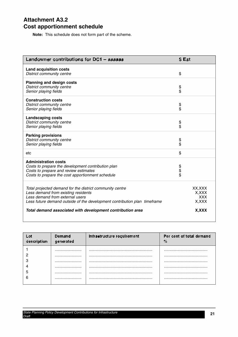
State Planning Policy Development Contributions for InfrastructureDraft
21
Attachment A3.2Cost apportionment schedule
Note: This schedule does not form part of the scheme.
Landowner contributions for DC1 – aaaaaa $ Est
Land acquisition costsDistrict community centre $
Planning and design costsDistrict community centre $Senior playing fields $
Construction costsDistrict community centre $Senior playing fields $
Landscaping costsDistrict community centre $Senior playing fields $
Parking provisionsDistrict community centre $Senior playing fields $
etc $
Administration costsCosts to prepare the development contribution plan $Costs to prepare and review estimates $Costs to prepare the cost apportionment schedule $
Total projected demand for the district community centre XX,XXXLess demand from existing residents X,XXXLess demand from external users XXXLess future demand outside of the development contribution plan timeframe X,XXX
Total demand associated with development contribution area X,XXX
Lot Demand Infrastructure requirement Per cent of total demanddescription generated %
1 ........................ ......................................................... .......................................2 ........................ ......................................................... .......................................3 ........................ ......................................................... .......................................4 ........................ ......................................................... .......................................5 ........................ ......................................................... .......................................6 ........................ ......................................................... .......................................

State Planning Policy Development Contributions for InfrastructureDraft
22
Attachment A3.3Development contribution plan report
Note: This report does not form part of the scheme.
Developmentcontribution area
Purpose
Period of the plan
Operation of thedevelopmentcontribution plan
Applicationrequirements
Principles
The development contribution area is shown on the scheme map as: DCA 1
The purpose of this development contribution plan is to
(a) enable the applying of development contributions for the developmentof new and upgrade of existing community infrastructure which isrequired as a result of increased demand generated in thedevelopment contribution area;
(b) provide for the equitable sharing of the costs of infrastructure andadministrative costs between owners;
(c) ensure that cost contributions are reasonably required as a result ofthe subdivision and development of land in the developmentcontribution area; and
(d) coordinate the timely provision of infrastructure.
X years from June 30 200X to June 30 20XX
The development contribution plan has been prepared in accordance with StatePlanning Policy 3.6 Development Contributions for Infrastructure. It will comeinto effect on the date of gazettal of the local planning scheme or amendment tothe local planning scheme to incorporate the development contribution plan.
Where a subdivision or development application or an extension of land use islodged which relates to land to which this development contribution plan applies,council shall take the provisions of the development contribution plan intoaccount in making a recommendation on or determining that application.
Development contributions will be applied in accordance with the followingprinciples:
1 Need and the nexus The need for the infrastructure included in thedevelopment contribution plan must be clearly demonstrated (need)and the connection between the development and the demandcreated should be clearly established (nexus).
2 Transparency Both the method for calculating the developmentcontribution and the manner in which it is applied should be clear,transparent and simple to understand and administer.
3 Equity Development contributions should be levied from alldevelopments in a development contribution area, based on theirrelative contribution to need.
4 Certainty All development contributions should be clearly identifiedand methods of accounting for escalation agreed on at thecommencement of a development.
5 Efficiency Development contributions should be justified on a whole-of-life capital cost basis consistent with maintaining financial disciplineon service providers by precluding over recovery of costs.
6 Consistency Development contributions should be applied uniformlyacross a development contribution area and the methodology forapplying contributions should be consistent.
State Planning Policy Development Contributions for InfrastructureDraft
23
Items included inthe developmentcontribution plan
Review
7 Right of consultation and review Developers have the right to beconsulted on the manner in which development contributions aredetermined. They also have the opportunity to seek a review by anindependent third party if they believe the contributions are notreasonable.
8 Accountable There must be accountability in the manner in whichdevelopment contributions are determined and expended.
Administration Costs• costs to prepare the development contribution plan• costs to prepare and review estimates• costs to prepare the cost apportionment schedule• valuation costs
Infrastructure elements• list of infrastructure required and basis for its inclusion
Details of the cost apportionment can be seen at schedule ZZ to thedevelopment contribution plan.
The development contribution plan will be reviewed when consideredappropriate having regard to the rate of subsequent development in the areasince the last review and the degree of development potential still existing.
The estimated infrastructure costs shown as schedule ZZ will be reviewed atleast annually to reflect changes in funding and revenue sources and indexedbased on Department of Housing and Works Building Cost Index.
2861/22183 Canning Bridge Rail Station Precinct StudyStrategic and Statutory Framework Report
GHD
GHD House, 239 Adelaide Tce. Perth, WA 6004P.O. Box Y3106, Perth WA 6832T: 61 8 6222 8222 F: 61 8 6222 8555 E: [email protected]
© GHD 2009
This document is and shall remain the property of GHD. The document may only be used for the purposefor which it was commissioned and in accordance with the Terms of Engagement for the commission.Unauthorised use of this document in any form whatsoever is prohibited.
Document Status
Reviewer Approved for IssueRevNo. Author
Name Signature Name Signature Date
0 S Jeffrey Akelderman A Kelderman 261009