Embed Size (px)
Citation preview
REPORT NO 1.0
SUDBURY RELIEF ROAD:STRATEGIC OUTLINEBUSINESS CASE
CONFIDENTIAL MARCH 2017
FinalConfidential
Project no: 70020874Date: March 2017
–WSP | Parsons Brinckerhoff70 Chancery LaneLondonWC2A 1AF
Phone: +44 020-7314-5000Fax: +44 020-7314-5111www.wsp-pb.com
SUDBURY RELIEF ROAD:STRATEGIC OUTLINE BUSINESSCASESuffolk County Council

Q U A L I T Y M A N A G E M E N TISSUE/REVISION FIRST ISSUE REVISION 1 REVISION 2 REVISION 3
Remarks First Draft Second Draft Final Final V2
Date 03/01/2017 03/01/2017 09/02/2017 15/03/2017
Prepared by Helen Scott Helen Scott Helen Scott Helen Scott
Signature
Checked by Jon Noble Jon Noble Jon Noble Jon Noble
Signature
Authorised by Jon Noble Jon Noble Jon Noble Jon Noble
Signature
Project number 70020874 70020874 70020874 70020874
Report number 1.0 1.0 1.0 1.0
ii
Sudbury Relief Road: Strategic Outline Business Case WSP | Parsons BrinckerhoffSuffolk County Council Project No 70020874March 2017 Confidential
P R O D U C T I O N T E A MCLIENT
Suffolk County Council Dave Watson
WSP | PARSONS BRINCKERHOFF
Associate Jon Noble
Principal Krissel Alcaraz
Engineer Helen Scott

iii
Sudbury Relief Road: Strategic Outline Business Case WSP | Parsons BrinckerhoffSuffolk County Council Project No 70020874Confidential March 2017
1 INTRODUCTION ...........................................................................1
2 SETTING THE SCENE .................................................................2
3 STRATEGIC CASE ......................................................................7
3.1 BUSINESS STRATEGY .................................................................................. 7
3.2 STRATEGIC AIMS .......................................................................................... 8
3.3 THE PROBLEM .............................................................................................. 9
3.4 THE OBJECTIVES ....................................................................................... 14
3.5 MEASURES FOR SUCCESS ........................................................................ 14
3.6 PROPOSED SOLUTION ............................................................................... 15
3.7 THE STRATEGIC FIT ................................................................................... 17
3.8 CONSTRAINTS ............................................................................................ 19
3.9 SCHEME BENEFITS .................................................................................... 24
3.10 SCHEME IMPACT ........................................................................................ 27
3.11 WHAT THE SCHEME WILL DELIVER .......................................................... 30
4 ECONOMIC CASE .....................................................................31
5 FINANCIAL CASE ......................................................................44
6 COMMERCIAL CASE ................................................................45
7 MANAGEMENT CASE ...............................................................47
A P P E N D I C E SA P P E N D I X A TABLE OF DEVELOPMENTSA P P E N D I X B APPRAISAL SUMMARY TABLE

1
Sudbury Relief Road: Strategic Outline Business Case WSP | Parsons BrinckerhoffSuffolk County Council Project No 70020874Confidential March 2017
1 INTRODUCTION
1.1 BACKGROUND
1.1.1 WSP | Parsons Brinckerhoff (WSP | PB) was commissioned by Suffolk County Council (SCC) tocomplete a Strategic Outline Business Case for a relief road in Sudbury.
1.1.2 This report builds upon the Sudbury Bypass Business Case: Strategic and Economic Analysiscompleted in 2015.
1.2 PURPOSE OF DOCUMENT
1.2.1 This Strategic Outline Business Case presents the evidence for constructing a new relief road inSudbury.
1.2.2 The business case investigates the robust case for change that fits with wider policy objectives. Itassesses the value for money of the project and highlights constraints.
1.2.3 This document will provide a platform for an Outline Business Case to be produced in the future.
1.3 DOCUMENT STRUCTURE
1.3.1 The remainder of the document is structured as follows:
à Previous studies and scheme description
à Strategic Case
à Modelling
à Economic Case
à Financial Case
à Commercial Case
à Management Case, and
à Conclusion.

2
Sudbury Relief Road: Strategic Outline Business Case WSP | Parsons BrinckerhoffSuffolk County Council Project No 70020874Confidential March 2017
2 SETTING THE SCENE2.1 SUDBURY
2.1.1 Situated in the southwestern part of Suffolk, Sudbury is a historic market town with a vibrant towncentre. This centre, with its Georgian and Victorian architecture, mixed with Grade 1 listedchurches, creates an attractive streetscape, drawing in residents and tourists alike.
Map 2-1 Map of Suffolk
2.1.2 Over the course of the twentieth century Sudbury, together with Great Cornard, experiencedsubstantial growth. New employment and retail areas were built in the town centre and at out-of-town (centre) locations to the south and east. Housing grew in the northern parts of the town andin Great Cornard. Today, the internationally recognised traditional silk weaving industry is stillrepresented, but new industries and office uses have developed as well.
2.1.3 Sudbury has a substantial history, famous Gainsborough landscapes, strong economy and isideally located among key towns such as Cambridge, Ipswich, Colchester and Bury St Edmunds.It has always played an important region function; serving the shopping, leisure, social andcultural needs of the residents. Its history, beauty and culture have successfully attracted touriststo the town and region for decades.

3
Sudbury Relief Road: Strategic Outline Business Case WSP | Parsons BrinckerhoffSuffolk County Council Project No 70020874Confidential March 2017
2.1.4 The town’s historic core is comprised of a medieval network of streets that are narrow and offerfew alternative routes for motor vehicles. Although the town has seen substantial growth since theSecond World War, due to the restrictions of its historic highway network, this growth has notachieved its potential and the beauty of the town centre remains hidden behind a queue of largevehicles.
Map 2-2 Map of Sudbury
2.1.5 The town is constrained to the west and south by the River Stour. The A131 corridor is the onlyaccess into and through Sudbury from the southwest and as such accommodates the strategiclorry network for the area.
2.2 A131/A134 CORRIDOR
2.2.1 The A131 / A134 corridor is a key route, providing a north- south connection between Chelmsford,Braintree, Halstead, Sudbury and Bury St Edmunds.
2.2.2 The A131 / A134 also provide links to the wider strategic road network:
à The A120 connects the A131 to Colchester and the A12 to the east and Bishop’s Stortfordand the M11 to the west
à The A1017 / A1124 connects the A131 at Halstead to Haverhill, and
à The A14 connects the A134 to Ipswich and Felixstowe to the east and the Midlands to thewest.
2.2.3 Map 2-3 overleaf shows the A131 / A134 and the important strategic connections of the route.

4
Sudbury Relief Road: Strategic Outline Business Case WSP | Parsons BrinckerhoffSuffolk County Council Project No 70020874Confidential March 2017
Map 2-3: A131 / A134 Corridor

5
Sudbury Relief Road: Strategic Outline Business Case WSP | Parsons BrinckerhoffSuffolk County Council Project No 70020874Confidential March 2017
2.3 PREVIOUS STUDIES
RELIEF ROAD – ORIGINAL SCHEME
2.3.1 As congestion has been an issue for Sudbury for many years, the idea for a relief road is not anew one. In 2001 Suffolk County Council and Babergh District Council published a LocalTransport Action Plan to address a wide range of transport problems in the area. The main focuswas the traffic that passed through Sudbury on the A131, and the resulting congestion, accidentsand negative impact on the town centre.
2.3.2 Four possible relief road corridors options were assessed.
2.3.3 The Local Transport Action Plan also included a do-minimum scheme that could be implementedin the short term. This would improve the quality of service and accessibility to the public transportnetwork and provide a series of sustainable transport measures.
2.3.4 Public consultation took place in October 2002 and a southern relief road received very littleacceptance from the local community. A western relief road received the most support out of theproposed options and was accepted by many as the most appropriate corridor to Sudbury andGreat Cornard’s traffic problems.
2.3.5 Work progressed on a potential alignment for and in 2003 Suffolk County Council produced A131Sudbury Bypass and Related Measures.
2.3.6 The document included full horizontal and vertical alignment for the road, a summary of the costs,benefits and impacts of final scheme.
2.3.7 The Transport Case for a relief road through the western corridor suggested an initial Benefit CostRatio (BCR) of 2.8, representing a high value for money (VfM) scheme. This could be furtherincreased by considering the wider economic benefits arrived from unlocking growth.
2.3.8 At that time there were a number of issues which needed to be addressed during later phases ofdesign and planning. The main concern was the environmental impacts: the alignment passedacross a former landfill site and the River Stour flood plain. The initial designs had not taken intoaccount the type of earthworks needed or ways to design the relief road to mitigate the impact tothe landscape.
SUDBURY BYPASS: REVIEW OF ENVIRONMENTAL ISSUES (WSP |PARSONS BRINCKERHOFF, SEPTEMBER 2015)
2.3.9 A Technical Note was produced in September 2015 which undertook a high level desk basedenvironmental review of the 2003 alignment in light of current selection criteria, with considerationof any changes to legislation and guidance, statutory designations, and other environmentalconstraints that may have arisen since the original route appraisal was undertaken. The TechnicalNote also considered whether an alternative route could be developed that would have a lessadverse impact on the environment that could be analysed further from an environmental andtransport planning perspective.
2.3.10 The review showed that the main land use and environmental constraints in the Sudbury areahave not altered significantly since 2003, and that biodiversity, landscape and heritage featuresstill remain the key constraints. However, for the majority of environmental constraints,environmental assessment / appraisal methodologies have been significantly updated orsuperseded by new policies.
2.3.11 The Technical Note concluded that an alternative alignment could be developed that would avoid:

6
Sudbury Relief Road: Strategic Outline Business Case WSP | Parsons BrinckerhoffSuffolk County Council Project No 70020874Confidential March 2017
à a former historic landfill site to the east of the previous alignment and adjacent to Bush Grove;
à noise sensitive receptors along Bush Grove, to the east of the previous alignment; and
à the UK BAP Priority Habitat Woodland at the south of the previous alignment.
2.3.12 However there still remain potential adverse impacts on the landscape, Belchamp Brook CWS;River Stour and associated floodplain habitats and the footpaths of the Valley Line walk which arestill the key environmental constraints.
2.3.13 The Technical Note recommended that further studies and surveys should be undertaken for thetopics which have been determined to be the key constraints namely landscape, heritage,biodiversity, River Stour and associated floodplain habitats and the footpaths of the Valley Linewalk.
WSP | PARSONS BRINCKERHOFF SUDBURY BYPASS BUSINESS CASE:STRATEGIC AND ECONOMIC ANALYSIS (2015)
2.3.14 Alongside the 2015 Environmental review, the strategic and economic case for a relief road wasbrought up to date. This study concluded that a relief road through the western corridor still had astrong business case with a BCR of 2.8 and was still a high value for money scheme.
2.3.15 It stated that the transport investment would alleviate the congestion Sudbury has experienced fordecades and lead Sudbury to becoming a Connected Town that could support and create newopportunities for businesses, jobs and housing.
2.3.16 The study identified the wider economic benefits, such as creating a region with innovativeindustries, supporting rural productivity and generating highly skilled jobs that will turn Sudburyinto the centre of a strong, inter-connected Eastern England.

7
Sudbury Relief Road: Strategic Outline Business Case WSP | Parsons BrinckerhoffSuffolk County Council Project No 70020874Confidential March 2017
3 STRATEGIC CASE3.1 BUSINESS STRATEGY
3.1.1 This strategic case sets out the case for investment for this much needed transport infrastructureimprovement on the A131, Sudbury. It demonstrates the problems faced in the area, the case forchange, the effect of the project and the benefits of the proposal.
3.1.2 The business case is promoted by the New Anglia Local Enterprise Partnership and SuffolkCounty Council working in partnership with Essex County Council, Babergh District Council andBraintree District Council
NEW ANGLIA LOCAL ENTERPRISE PARTNERSHIP
3.1.3 The New Anglia Local Enterprise Partnership was established by Government in 2010 andrepresents one of the fastest growing regions in the country, with 1.6 million people and around55,000 businesses.
3.1.4 It is a business-led collaboration between the private, public and education sectors across Norfolkand Suffolk with an ambition to drive economic growth and transform the local economy into aglobal centre for talent and innovation.
3.1.5 It is responsible for shaping the economic landscape for businesses in Suffolk and Norfolk.
SUFFOLK COUNTY COUNCIL
3.1.6 Suffolk County Council is the Local Highway Authority for Suffolk. It is responsible for the roadsand highway infrastructure in Sudbury. Through strong financial management, innovation, localleadership and market development, it provides or enables the provision of good-quality servicesfor Suffolk people.
3.1.7 Suffolk County Council and the New Anglia Local Enterprise Partnership have come together withshared vision and aims to promote this Business Case.
ESSEX COUNTY COUNCIL
3.1.8 Essex County Council is the Local Highway Authority for Essex. It is responsible for the roadsand highway infrastructure in Braintree District, which neighbours Suffolk County. HighwaysEngland is responsible for strategic route network, which includes the A120 and A12.
3.1.9 Essex County Council is committed to facilitating growth and understands that improvedhighways and transport infrastructure plays an important role in enabling development andbusinesses to grow.
DEPARTMENT FOR TRANSPORT
3.1.10 Central Government understands that there is a need for Public Sector investment in Suffolk tohelp achieve regional growth and productivity targets.
8
Sudbury Relief Road: Strategic Outline Business Case WSP | Parsons BrinckerhoffSuffolk County Council Project No 70020874Confidential March 2017
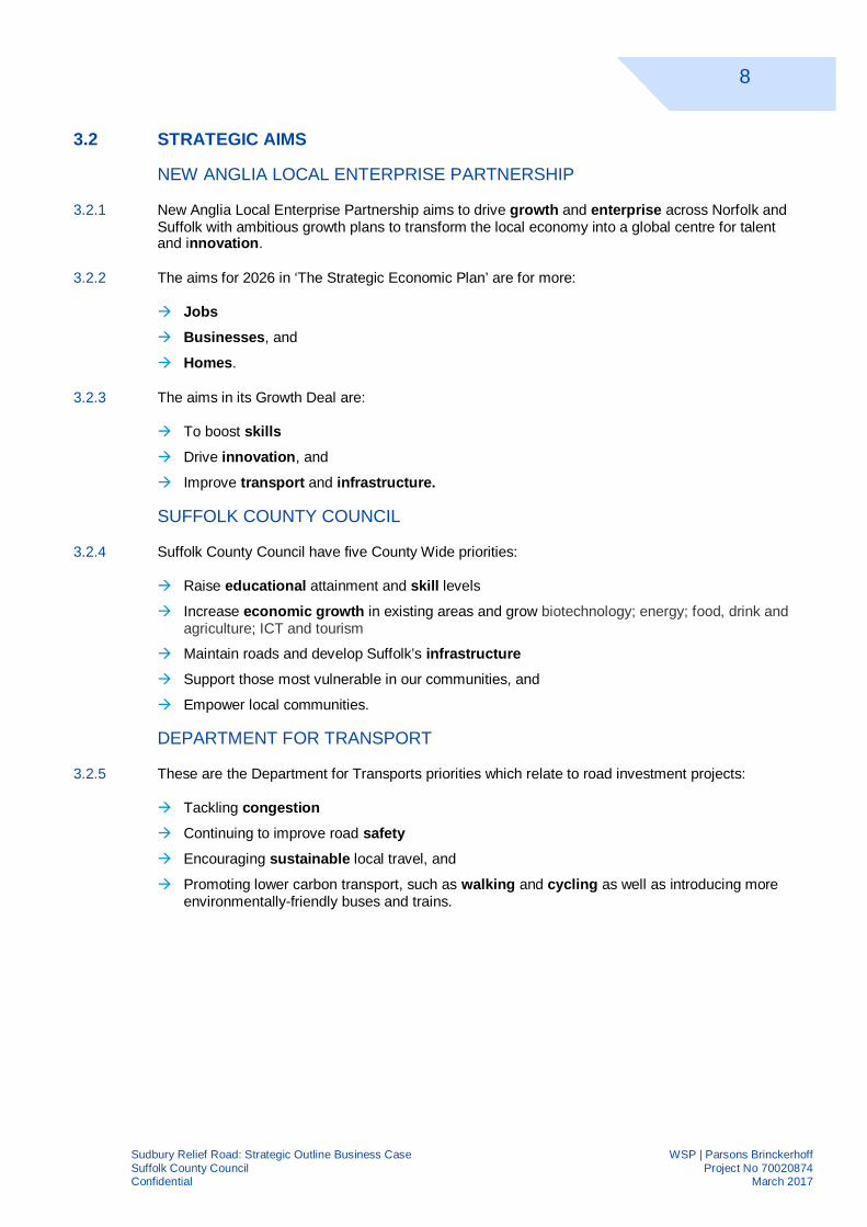
3.2 STRATEGIC AIMS
NEW ANGLIA LOCAL ENTERPRISE PARTNERSHIP
3.2.1 New Anglia Local Enterprise Partnership aims to drive growth and enterprise across Norfolk andSuffolk with ambitious growth plans to transform the local economy into a global centre for talentand innovation.
3.2.2 The aims for 2026 in ‘The Strategic Economic Plan’ are for more:
à Jobsà Businesses, and
à Homes.
3.2.3 The aims in its Growth Deal are:
à To boost skillsà Drive innovation, and
à Improve transport and infrastructure.
SUFFOLK COUNTY COUNCIL
3.2.4 Suffolk County Council have five County Wide priorities:
à Raise educational attainment and skill levels
à Increase economic growth in existing areas and grow biotechnology; energy; food, drink andagriculture; ICT and tourism
à Maintain roads and develop Suffolk’s infrastructureà Support those most vulnerable in our communities, and
à Empower local communities.
DEPARTMENT FOR TRANSPORT
3.2.5 These are the Department for Transports priorities which relate to road investment projects:
à Tackling congestionà Continuing to improve road safetyà Encouraging sustainable local travel, and
à Promoting lower carbon transport, such as walking and cycling as well as introducing moreenvironmentally-friendly buses and trains.

9
Sudbury Relief Road: Strategic Outline Business Case WSP | Parsons BrinckerhoffSuffolk County Council Project No 70020874Confidential March 2017
3.3 THE PROBLEM
3.3.1 Sudbury and the surrounding area are facing major transport and development problems, suchas:
à Congestion in Sudbury town centre causing issues for local residents and businesses.
à Congestion through Sudbury causing delay on the Primary Route Network.
à Congestion on the Strategic Road Network A11, A12 and A120, of which some traffic couldbe better served by an improved route through Sudbury.
3.3.2 These transport problems are part of the reason behind development and growth problems in thearea:
à Growth in Sudbury has been stifled over recent years.
à Further growth in the area is restricted by poor connectivity.
à Sudbury is failing to be the connected town it could be, providing a suitable base for new andexpanding businesses.
CONGESTION IN SUDBURY TOWN
3.3.3 High volumes of traffic are funnelled through the historic town centres medieval road network.These narrow roads form a convoluted one way system.
3.3.4 As a result, the town centre is congested with cars and HGVs, particularly during peak periods.Gregory Street experiences an average of 636 and 823 vehicles during the AM and PM peakperiods (data from traffic survey undertaken in April 2016).
3.3.5 This has inevitably resulted in noise and air quality problems within Sudbury and there is currentlyan Air Quality Management Area (AQMA) encompassing part of Cross Street. The pollutionidentified, Nitrogen Dioxide, exceeds the allowed annual mean. The images in Figure 3-1, takenon a weekday in October (2015), show the congestion in the town centre.
Figure 3-1 Sudbury Town Centre Congestion
3.3.6 There is a high volume of HGVs travelling through the town. These heavy vehicles often moveslowly and this results in vehicles frequently breaking. The trafficked area is extremely close toresidential buildings, shops and businesses. The result is regular and significant levels of trafficnoise.

10
Sudbury Relief Road: Strategic Outline Business Case WSP | Parsons BrinckerhoffSuffolk County Council Project No 70020874Confidential March 2017
CONGESTION THROUGH SUDBURY
3.3.7 Sudbury town centre is ideally located to benefit from its connection with and between key towns,cities and services in the region.
3.3.8 Regional traffic could be using the A131, the A134 and the A1071 to travel around West Suffolk.However, the historic highway network through Sudbury town centre is causing significant delayto journeys through Sudbury.
3.3.9 The problems are exacerbated by the one-way system in the town centre, which results from thenarrow historic highway network. The route from Braintree to Bury St. Edmunds and Newmarketjoins with local traffic on a narrow one way gyratory. The width of the road reduces in the towncentre and there are a large number of junctions and a significant quantity of on street parking.This road is not suitable to carry such volumes of traffic.
3.3.10 A review of historic journey time information through Sudbury shows that during the peak periods,normal journeys through Sudbury can increase by at up to 4 minutes compared to off peakperiods. During periods of traffic management, the road network provides very little resilience andthe impacts are major.
CONGESTION ON THE STRATEGIC ROAD NETWORK
3.3.11 The M11, which is the only significant length of Motorway in East Anglia and a major north-southlink from London to Cambridge and much of northern East Anglia, has been facing congestion inrecent times.
3.3.12 The non-dualled sections of the A120, which runs between the M11 and A12, is also congested.Proposals for dualling this section are underway, which promises to deliver growth opportunitiesto the region. These improvements are likely to release suppressed demand for east/westmovements in this area, as there are no dual carriage routes between the M25 and the A14.
3.3.13 The A12, which connects the M25 with the A14 is congested along most of its entire length, withsignificant issues around Colchester and at the A12/A14 Copdock Interchange in Ipswich.
3.3.14 The congestion along these strategic routes has led to poor levels of service for all motorists.
3.3.15 The traffic volume along this heavily over-capacity network is expected to increase in the futurewith congestion becoming progressively worse.
3.3.16 The A131/A134 route runs in between the M11 and A12 corridors and has the potential to servetraffic which currently chooses to use the Strategic Road Network.
REDUCED GROWTH IN SUDBURY
3.3.17 These traffic issues results in:
à Fewer people passing through Sudbury
à Fewer people coming to Sudbury, and
à Fewer people wanting to live in Sudbury
3.3.18 This is limiting new businesses starting up in Sudbury, stifling the growth of existing businessesand reducing the value.
3.3.19 If nothing is done, the problem will not only persist but get worse.

11
Sudbury Relief Road: Strategic Outline Business Case WSP | Parsons BrinckerhoffSuffolk County Council Project No 70020874Confidential March 2017
GROWTH DESIRED IN THE AREA
3.3.20 Several housing, employment and retail land use developments are already proposed for areaswithin Suffolk and to the north of Essex. A review of the relevant local plans as well as Baberghand Mid Suffolk’s Joint Strategic Housing Land Availability Assessment suggests there are:
à 2,705 committed residential dwellings that will be delivered in the short term and
à 4,059 proposed residential dwellings that do not yet have planning permission status.
3.3.21 The location of the developments are shown in Map 3-1 below; Appendix A provides more detailfor each development.
3.3.22 The additional developments will add to the existing congestion on the regional network. Inabsence of the proposed relief road, developments surrounding Sudbury will further contribute tothe high level of congestion found within Sudbury town centre and will increase delay on theA131.
Map 3-1: Developments in Suffolk and Essex

12
Sudbury Relief Road: Strategic Outline Business Case WSP | Parsons BrinckerhoffSuffolk County Council Project No 70020874Confidential March 2017
GROWTH DESIRED IN SUDBURY
3.3.23 Sudbury has the potential to play an even larger role in supporting the economic growth of theregion, but it is hindered by severely lacking road infrastructure. These traffic levels haveconstrained the economic development that is needed in the region.
3.3.24 Babergh District Council has plans to add more jobs and housing across the district and Sudburywould struggle to meet these demands.
3.3.25 Essex County Council and Braintree District Council are considering plans to provide additionaljobs and housing in the Braintree to Sudbury area. This growth would be challenging along theA131/A134 corridor without transport infrastructure improvements.
3.3.26 Such ambitions may only be realised following improvements to the A131/A134 corridor; thesewould begin with Sudbury as a first phase with others following later (including at Halstead).

13
Sudbury Relief Road: Strategic Outline Business Case WSP | Parsons BrinckerhoffSuffolk County Council Project No 70020874Confidential March 2017
SUDBURY FAILING TO BE THE CONNECTED TOWN
3.3.27 Sudbury is a key town in the western part of Suffolk that could offer quick and easy connections todestinations in Suffolk and East Anglia as illustrated by the graphic below.
3.3.28 However, the ability of the town to perform this key regional role has been stifled by congestion.
3.3.29 Sudbury as a Connected Town would see it having a far greater regional influence. Offering anincreased range of services to areas further afield.
3.3.30 More people would travel on the roads around Sudbury and would begin to make Sudbury a placeto come and visit on these travels. No longer put off by congestion and delays.

14
Sudbury Relief Road: Strategic Outline Business Case WSP | Parsons BrinckerhoffSuffolk County Council Project No 70020874Confidential March 2017
3.4 THE OBJECTIVES
3.4.1 Having reviewed the key issues and opportunities that are facing the area, the risks of not doinganything and the support for doing something, four key objectives of the scheme have beendeveloped. The primary and secondary objectives are included in the Table below.
Table 3-1: Objectives
PRIMARY OBJECTIVES SECONDARY OBJECTIVES
Enable growth within Sudbury and thesurrounding area
Facilitate the delivery of new homes and jobs withinSuffolk and Essex
Improve Sudbury town centre To improve the quality of life for residents, workers andshoppers by reducing traffic, air and noise pollution.
Reduce congestion
Improve journey times in Sudbury and the surroundingarea and reduce the amount of time wasted queueing.
Improve road safety, with a relief road designed to DMRBsafety standards
Improve the connectivity of Sudbury
People more likely to travel to Sudbury.
People more likely to make journeys which includeSudbury.
Businesses benefitting from being more active within theregion.
3.5 MEASURES FOR SUCCESS
3.5.1 Successful delivery of the objectives would:
à Facilitate additional new homes
à Enable an increase in jobs and skills in Sudbury along with a reduction in worklessness
à Generate an additional council tax revenue
à Increase GVA in Sudbury and along the A131/A134 corridor, and
à Stimulate uplift in tourism through an improved town centre.
15
Sudbury Relief Road: Strategic Outline Business Case WSP | Parsons BrinckerhoffSuffolk County Council Project No 70020874Confidential March 2017
3.6 PROPOSED SOLUTION
3.6.1 An early design was produced which takes a route through the preferred western corridor andattempt to reduce its environmental impact as much as practicable. This indicative schemeallowed the transport benefits to be calculated and provided more information to theenvironmental assessment. The scheme would enable traffic to travel between the A131 and theA134 without having to travel through Sudbury town centre.
3.6.2 An option assessment process will be undertaken during the next phase of design and planning,with an Outline Business Case being produced to describe the benefits and constraints of apreferred option.
3.6.3 The indicative western relief road is 3.5 km in length, single carriageway road with a speed limit of60mph.
3.6.4 The indicative route would run through to the west of Sudbury, and to the east of the villages ofBulmer and Borley.
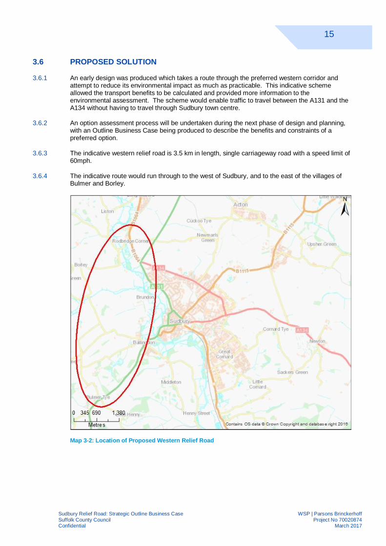
Map 3-2: Location of Proposed Western Relief Road

16
Sudbury Relief Road: Strategic Outline Business Case WSP | Parsons BrinckerhoffSuffolk County Council Project No 70020874Confidential March 2017
3.6.5 The road commences from the Sudbury Road / Melford Road / A134 roundabout and meets theA131 to the South. Table 3-2 below shows the work required.
Table 3-2: Proposed work for relief road by section
SECTION PROPOSED WORK
1à Additional arm on the Sudbury Road Melford Road A134 junction.
à New “at grade roundabout” (four arm entry) for crossing over “Kitchen Hill” Road.
à Construction of new three-entry roundabout on A131.
2 à Construction of approximately 3500 metres of new road.
3
à New bridge over River Stour.
à New bridge over “The Valley Walk”.
à New underpass drains.
à New bridge over footpath.
à New bridges over farmer’s access for livestock/machinery.
à New bridge over access road to existing refuse tip (public).
à New underpass access.

17
Sudbury Relief Road: Strategic Outline Business Case WSP | Parsons BrinckerhoffSuffolk County Council Project No 70020874Confidential March 2017
3.7 THE STRATEGIC FIT
3.7.1 The following describes how a western relief road complies with local and regional policies.
SUFFOLK COUNTY COUNCIL LOCAL TRANSPORT PLAN
3.7.2 Suffolk County Council’s Local Transport Plan 2011-2031 notes Sudbury as a key urban centrefor growth where transport interventions can have a significant impact.
3.7.3 The plan highlights Sudbury as a key location to provide an increase in employment opportunities.
3.7.4 Sudbury is described as having severe air quality problems as a result of heavy goods vehiclequeuing at obstructions. An Air Quality Action Plan has been put in place in an attempt to reducethis issue.
3.7.5 The plan agrees that the community of Sudbury is suffering as a result of the traffic issues. Ithighlights that severance is occurring due to difficulties of crossing the A12, A1071 and A137 toreach services.
3.7.6 A relief road is listed as a required transport intervention to resolve a key transport issue.
BABERGH DISTRICT COUNCIL LOCAL PLAN
3.7.7 Babergh District Council published in 2014 a Core Strategies & Policies document. This,alongside the emerging Local Plan 2011-2031, sets out the potential for business and housinggrowth, job creation and development. As the largest town in the District, Sudbury plays asignificant role in helping to achieve these targets. However developers and house builders arefinding it difficult to achieve those targets.
3.7.8 The Local Plan is jobs led and sets out the level of growth needed to meet the district’s aspiration.The 9,720 new jobs in a 30-year plan (to 2031) will require 485 new jobs per year. To meet thiseconomic intensification, 5,975 new dwellings are to be built across the District over the planperiod. Delivery of the dwellings is phased: 220 dwellings per annum in the first five years (2011-2016), rising to 325 dwellings per annum in the later years of the plan.
3.7.9 Babergh District Council plans to distribute the developments across the district in both the urbancentres and rural areas. The plan shows 60% of the housing growth will be provided in urbanareas (Sudbury/Great Cornard, Hadleigh, and the Babergh Ipswich Fringe) and 40% across therural areas.
3.7.10 When the Local Plan was first developed the Sudbury/Great Cornard area was to receive about aquarter of housing allocated to urban areas.
3.7.11 The Babergh Local Plan Alternation No.2 (2006) Saved Policies allocated 19 hectares of land forresidential development and 20.2 hectares for general employment and low impact employmentat Chilton. However limited progress has been made bringing this plan forward.
3.7.12 Babergh and Mid Suffolk District Councils are working together to develop a new Joint Local Plan.This includes discussions about new growth figures for Babergh and Mid Suffolk. As the Councilsidentify their Objectively Assessed Need (OAN), additional development opportunities in Sudburymay be desirable. These numbers are not yet finalised and will need to be agreed upon betweenthe District and the County.
18
Sudbury Relief Road: Strategic Outline Business Case WSP | Parsons BrinckerhoffSuffolk County Council Project No 70020874Confidential March 2017
3.7.13 The cumulative delivery of housing from the Core Strategy start period of 2011 to 2015 is 7%above target. This is due to some large developments which have come forward early on in theplan. However recent build out rates for Babergh as a whole are poor and have begun tounderperform. If the level of development remains at its current levels, the District will not deliverthe level of new housing needed. The councils are reviewing possible factors that are limitinghousing delivery. This review includes discussions with local developers.
3.7.14 Several factors are likely to be contributing to the slow down for Babergh and West Suffolk. Thenarrow congested road network is perhaps the most crucial.
BRAINTREE DISTRICT COUNCIL CORE STRATEGY (2011)
3.7.15 Braintree District Council Core Strategy outlines a vision of change between now and 2026. Thedocument sets out how and where the district will meet its need for housing, employment andretail development.
3.7.16 The strategy outlines:
à 9,625 dwellings are required between 2011 and 2026 to meet the needs of the District; and
à A need to provide jobs to maintain a strong local economy.
3.7.17 The area along the A131 between Braintree and Halstead could provide an important part ofthese proposals.
IMPROVING THE ESSEX ROAD NETWORK (DECEMBER, 2016)
3.7.18 Essex County Council has proposed improvements for the A120. The A120 between Braintreeand the A12 is one of the most important east to west roads in Essex, yet has become one of themost congested. This has led to poor levels of service for drivers, including poor reliability andqueuing traffic. Essex County Council are investigating the feasibility of a dual carriageway toreduce journey times and improve the reliability of the east to west route.
BRAINTREE LOCAL PLAN – INTERIM ASSESSMENT (JUNE 2016)
A120 BRAINTREE TO A12 ROUTE OPTIONS
3.7.19 Highways England has asked the County Council to lead on the feasibility work to determineoptions for a new A120 route between Braintree and the A12 by summer 2017. A range ofpossible options to increase the capacity of the A120 have been assessed. Essex CountyCouncil and Highways England will recommend its preferred route to the Government forinclusion in the next Government Road Investment Strategy (RIS), which will run from 2020 to2025.
A131 ROUTE BASED STRATEGIES
3.7.20 The A131 between Braintree and Chelmsford has seen recent improvements, which formed partof the Essex County Council Route Based Strategies.
3.7.21 The A130 / A131 Chelmsford to Braintree Route Based Strategy also propose a number ofoptions. These include: improved signing and road lining across the route, improving the busprovision along the route including an express bus service between Chelmsford and Braintree.Highway improvements aimed at reducing congestion include addressing the capacity problem atSheepcotes roundabout.

19
Sudbury Relief Road: Strategic Outline Business Case WSP | Parsons BrinckerhoffSuffolk County Council Project No 70020874Confidential March 2017
3.8 CONSTRAINTS
3.8.1 This section outlines the possible constraints the scheme may face at this stage.
PLANNING CONSTRAINTS
3.8.2 Possible planning constraints include:
à This type of work takes time, as various environmental and stakeholder groups will need to beconsulted
à To capitalise on growth in the surrounding areas the relief road should be built as soon aspossible. A balance between a speedy programme and an environmentally sensitive reliefroad route will need to be struck
à Uncertainty of funding, and
à Uncertainty of construction time.
ENVIRONMENTAL CONSTRAINTS
NOISE
3.8.3 One of the aims of the relief road is to remove much of the traffic going through Sudbury.However, a number of properties, currently in a semi-rural setting, are likely to be affected by thenew road. A summary of the noise-sensitive receptors in the study area is presented below:
à Kitchen Farm Cottages and Kitchen Farmhouse (approximately three dwellings)
à Dwellings at Kitchen Hill (approximately 21 dwellings)
à New Cottages
à Barley Mill Cottage
à Dwellings on Melford Road

20
Sudbury Relief Road: Strategic Outline Business Case WSP | Parsons BrinckerhoffSuffolk County Council Project No 70020874Confidential March 2017
AIR QUALITY
3.8.4 Air quality across Sudbury is currently good, although pockets of poor air quality exist particularlyin the southwest of the town. Babergh District Council has designated an Air QualityManagement Area (AQMA) for exceedances of the annual mean standard for Nitrogen Dioxide in2008 around the Cross Street area of Sudbury. There are no automatic monitoring sites withinthe Babergh District, however, Babergh District Council have undertaken diffusion tubemonitoring, with the primary focus being the AQMA.
3.8.5 In 2014, there were multiple monitored exceedances of the NO2 annual mean standard at relevantreceptors, although all of these were roadside locations and within the designated AQMA. Defrabackground mapping in this area shows background concentrations between 9 - 15µg/m3, thisindicates that the roadside contribution to NO2 contributes a significant proportion of themonitored exceedances. Monitored concentrations generally show little / no reduction inmonitored NO2 concentrations over the last 5 years.
3.8.6 There are relatively few properties within 100m of the assessed route, and background NO2concentrations within this region are relatively low. Due to this, the sensitivity of this area to NO2impacts is considered to be relatively low. Conversely, the town of Sudbury is relatively denselypopulated, and concentrations are relatively high, especially the area within the AQMA. Thereforethe sensitivity of this area to NO2 impacts is considered to be relatively high.
3.8.7 The nearest statutory designated ecological sites to study area are the Glemsford Pits Site ofSpecial Scientific Interest (SSSI) and Cornard Mere SSSI, approximately 3km to the northwestand southeast respectively.

21
Sudbury Relief Road: Strategic Outline Business Case WSP | Parsons BrinckerhoffSuffolk County Council Project No 70020874Confidential March 2017
LANDSCAPE
3.8.8 The western relief road corridor comprises a predominantly agricultural landscape of the StourValley on the western side of Sudbury. The route of a relief road is likely to connect theA134/A131/B1064 junction on the northern edge of Sudbury with the A131 at Ballingdon Hill tothe south-west of the town.
3.8.9 Much of the site and surrounding area is recognised through landscape designations, includingthe ‘Stour Valley Project Area’ and Dedham Vale AONB. Although the Stour Valley Project Areacurrently falls outside the AONB, it is situated within the area of search for the AONB boundaryreview i.e. the proposed boundary extension, reflecting the high value and quality of thelandscape. If the AONB was extended to include the maximum area of search, the study areawould lie just inside the AONB. It would fall fully within the area that forms the setting to theAONB, i.e. it is either visible from the AONB or the AONB can be seen from it. The site is alsopartly located within the locally designated ‘Stour Valley Special Landscape Area (SLA)’ which ishighly valued for its natural beauty and landscape views. The Stour Valley has historic andcultural associations with the nationally recognised artist Thomas Gainsborough. The viewpointfrom the Auberies for Gainsborough’s painting ‘Mr and Mrs Andrews’ (1750) overlooks part of thestudy area which, through this association, adds cultural value to aspects of the landscape.
3.8.10 A well-developed network of Public Rights of Ways and recreational areas, including commonlands, lie within the Stour Valley. Recreational routes within the study area include the StourValley Path and St Edmunds Way to the east; The Valley Walk, which follows the disused railwayline between Rodbridge Corner on the southern edge of Long Melford and Sudbury Station; TheGainsborough Trail, a circular route approximately 20km around the Sudbury area; and MeadowWalk, a 5km section of the Gainsborough Trail along the disused railway line between Brundonand the centre of Sudbury. In addition a Sustrans traffic free cycle route (NCR 13) follows theroute of The Valley Walk along the disused railway line.
3.8.11 The northern section of the site lies within low lying floodplains (c. 20-30m AOD) of LandscapeCharacter Area (LCA) 26 Valley Meadowlandsi with its distinctive meadows and riverside treescontributing significantly to the distinctive character of the district and sense of place. Here a reliefroad would cross the River Stour, Belchamp Brook and a disused railway line via overbridges.Between Belchamp Brook and Sandy Hill the site lies within LCA 18 – Rolling Valley Farmlandswhich comprises higher (c. 30-50m AOD), undulating valley sides. Agricultural land in this arearetains its historic pattern of medium size fields enclosed by tall hedgerows with abundanthedgerow trees and is traversed by historic sunken lanes on the valley sides. Views over this areaare widely available from the historic part of Sudbury (designated as ‘Sudbury ConservationArea’), which contributes to the scenic quality of the area. The southern end of the site lies withinLCA 4 – Ancient Rolling Farmlands which comprises rolling arable farmland (c. 60-80m AOD) ofancient enclosure patterns with hedgerows and ditches which combine to create a feeling ofintimacy in places. This largely intact landscape is also crossed by a dense network of windinglanes and paths.
3.8.12 At a local level Babergh Council believe the landscape of the districts to be a ‘heritage asset’. Theneed to safeguard the countryside and heritage of the area is captured in Babergh Core StrategyObjective 6 and Saved Policy CRO4 of the Babergh Local Plan. Recognition of the need toprotect the distinctive countryside and heritage of the area is consistent across all relevantlandscape planning policies at a national and local level.
3.8.13 The study area has a distinctive sense of place due to the topography, woodland cover, land use,historic field patterns, settlement pattern and high levels of tranquillity which prevail throughout.Considering this and the number of designations present, the landscape is of high value and hasa high susceptibility to the type of change proposed. This results in high landscape sensitivity.

22
Sudbury Relief Road: Strategic Outline Business Case WSP | Parsons BrinckerhoffSuffolk County Council Project No 70020874Confidential March 2017
HISTORIC ENVIRONMENT
3.8.14 A total of five scheduled monuments, 11 Grade I, 16 Grade II* and 326 Grade II Listed Buildingsare present in the outer study area (up to 2km from the centreline of the study area), mostlylocated with Sudbury itself. Three conservation areas, including Sudbury, and two historiclandscapes were also identified.
BIODIVERSITY
3.8.15 No internationally or nationally statutory designated sites occur within the likely Zone of Influenceof the relief road. The disused railway which traverses the study area forms part of the RailwayWalks Local Nature Reserve (LNR) which supports woodland, scrub and grassland habitats; anationally notable plant species Deptford pink Dianthus armeria occurs within the designated site.The Sudbury Common Lands LNR occurs in the south east of the study area. These sites receiveprotection through planning policy. It is important to note that information regarding the presencelocal non-statutory designated sites has not been collated as this was beyond the scope of thepreliminary baseline study; if they are present within the study area, this could pose a significantconstraint a relief road.
3.8.16 Two rivers, Belchamp Brook and the River Stour, and their associated floodplains occur within thestudy area. These are ecologically important habitats that provide resources for a broad range ofspecies. Effects on watercourses can have negative impacts at broad geographic scales.Watercourses receive protection under the Water Framework Directive.
3.8.17 An area of ancient woodland (Brundon Wood) occurs within the study area, a habitat type of highconservation value. In addition other priority habitats, as identified under Section 41 of the NaturalEnvironment and Rural Communities act (NERC) 2006, occur within the study area. Theseinclude hedgerows, coastal floodplain and grazing marsh, lowland mixed deciduous woodlandand lowland calcareous grassland. Notable / rare flora could occur within the study area includingin association with the watercourses and arable fields; further survey will be required to establishwhether species are present and their distribution. Under the NERC Act (2006) governmentbodies are obliged to have regard to the conservation of biodiversity; priority habitats (andspecies) are identified as a guide to exercising their duties.
3.8.18 A number of legally protected and / or notable fauna species could occur within the study area,although further survey would be required to inform a full constraints assessment. The study areais certain to be used to some degree by populations of bats, birds (over winter and breeding),invertebrates and fish; these populations are likely to be of some conservation importance basedon the habitats present. The study area also has the potential for supporting a range of legallyprotected species including hazel dormouse, reptiles, amphibians, water vole and otter; thepresence of these species could present significant constraints.
SURFACE WATER FEATURES
3.8.19 A relief road would cross over two main rivers: the River Stour and Betchamp Brook. Both ofthese watercourses are monitored against the objectives of the Water Framework Directive. TheRiver Stour is classified as a heavily modified waterbody with an overall quality status of‘moderate’ comprising ‘moderate’ ecological quality and ‘good’ chemical quality. Betchamp Brookis assessed to have an overall quality status of ‘poor’ comprising ‘poor’ ecological quality and‘good’ chemical quality.

23
Sudbury Relief Road: Strategic Outline Business Case WSP | Parsons BrinckerhoffSuffolk County Council Project No 70020874Confidential March 2017
GROUNDWATER FEATURES
3.8.20 A relief road would likely be located within Zone 2 of a designated Groundwater Source ProtectionZone which indicates those aquifers used to support public drinking water supplies. Zone 2 isdefined as the area within which groundwater will take a maximum of 400 days to travel from anypoint within the area to the point of abstraction.
3.8.21 Review of borehole records obtained via the Geology of Britain viewer suggests a groundwaterlevel in the region of approximately 22mAOD. The topography within the study area is undulatingbut broadly ranges between 30mAOD to 50mAOD, increasing to approximately 75mAOD at thejunction with the A131 Ballingdon Hill in the south.
3.8.22 Groundwater within the study area is monitored against the objectives of the Water FrameworkDirective. North of Kitchen Hill is located within the North Essex Chalk catchment with an overallquality status of ‘poor’ comprising ‘poor’ quantitative quality and ‘poor’ chemical quality. South ofKitchen Hill is located within the Essex Gravels catchment with an overall quality status of ‘poor’comprising ‘good’ quantitative quality and ‘poor’ chemical quality.
FLOOD RISK
3.8.23 A relief road would pass through an extensive area of fluvial Flood Zone 3 associated with theRiver Stour. Land within Flood Zone 3 is assessed to have a greater than 1% (1 in 100) annualprobability of flooding from fluvial sources. The flood extent within the area crossed by a reliefroad is also likely to comprise the functional floodplain Flood Zone 3b where the annual probabilityof flooding is greater than 5% (1 in 20). It is assumed that a relief road would be located on anembankment to the north and south of the River Stour within the mapped flood extents. It is notyet clear if a clear span structure will be provided across the River Stour.
3.8.24 A relief road would pass though the fluvial Flood Zone 3 associated with Betchamp Brook and itsminor tributary located immediately to the north of the brook. This is considered likely to includefunctional floodplain. It is assumed that there would be a clear span structure crossing both ofthese watercourses, but that an embankment will be constructed within the mapped Flood Zone 3to the north and south of Betchamp Brook.
3.8.25 Surface water flooding within the study area is generally low. The most significant risks areassociated with the River Stour and Betchamp Brook as discussed above. Overland flow routesare also indicated to the north of Kitchen Hill and along the alignment of the watercourse to theeast of the Auberies Estate Lake.
STAKEHOLDERS
3.8.26 Early discussions have taken place between most of the key stakeholders shown below:
à Suffolk County Council
à Babergh District Council
à Braintree District Council
à Essex County Council
à Sudbury Town Council
à Highways England

24
Sudbury Relief Road: Strategic Outline Business Case WSP | Parsons BrinckerhoffSuffolk County Council Project No 70020874Confidential March 2017
3.9 SCHEME BENEFITS
JOURNEY TIME SAVINGS
3.9.1 The provision of a new relief road provides journey time savings to travellers on the A131.
3.9.2 The existing A131 route through Sudbury town centre has an average journey time of 295seconds in the PM peak. The indicative western relief road has an average journey time of 149seconds; resulting in a saving of over 2 minutes for all users of the new route. Empirical evidenceindicates that peak hour traffic can lead to gridlock in Sudbury, and therefore journey time savingsmay be greater.
3.9.3 Removing vehicles from the town centre also reduces the journey times of vehicles using thecurrent A131 within Sudbury.
Route used within model without Relief Road Route used within model with Relief Road
REDUCTION OF VEHICLES IN THE TOWN CENTRE
3.9.4 The relief road would relieve the key routes within Sudbury town centre, removing some 600vehicles during the PM peak. There would also be a 60% reduction in the number of HGVs withinSudbury.
3.9.5 The SATURN modelling shows that the majority of vehicles on the A131 would change to usingthe relief road; as the current route along the one-way gyratory is poor.
3.9.6 The relief road has a positive effect on the wider Sudbury network, with reductions on B1115(Waldingfield Road / East Street), Shawlands Avenue to the east and A1092 (Westgate Street) tothe north.
3.9.7 The reduced number of vehicles through Sudbury would lead to the following additional benefits:
à Reduced noise pollution and enhanced air quality (especially given the high number of HGVmovements being removed from the town), and
à The re-routing of vehicles onto the relief road will create extra capacity for local journeys e.g.shoppers/workers travelling to Sudbury town centre.
3.9.8 The reduction of traffic in the town is not as large as first might be expected. This is in part due tothe difficulties faced by many people travelling through the town at the moment, and relieving thiscongestion allows some of these people to change their travel behaviour. This would be ofbenefit to residents of Sudbury, as well as the businesses and retail establishments as morejourneys can be made where Sudbury is the destination.
25
Sudbury Relief Road: Strategic Outline Business Case WSP | Parsons BrinckerhoffSuffolk County Council Project No 70020874Confidential March 2017
3.9.9 A relief road would also allow Sudbury to have a reimagined town centre; as a place for people tovisit. Providing an Enhanced Local Centre would allow Sudbury to grow sustainably as required.
3.9.10 Improvements to the town centre could lead to:
à Town centre parking which better fits with the streetscape
à A town centre made for pedestrians to freely use
à Better use the historic market area
à Increasing the amount of usable outdoor space (café styleand community seating), and
à Improved safe and sustainable access into the town, whichwill support economic growth.
REDUCTION IN TRAFFIC ON KEY REGIONAL ROUTES
3.9.11 The improved A131 / A134 north-south connection also attracts users that currently usealternative routes, resulting in improvements on these congested routes. The model showed thata relief road would lead to the following reductions in vehicle numbers in 2021:
à The M11 between A120 and A11: 221 vehicles in the AM and 60 vehicles in the PM.
à The A120 between A12 and A131: 51 vehicles in the AM and 27 vehicles in the PM.
à The A12 south of London Road: 14 vehicles in the AM and 16 vehicles in the PM.
3.9.12 The A134, south of Bury Road, is expected to have an increase in vehicles in 2021 due to therelief road re-routing traffic. However, the additional traffic does not result in capacity issues.
CAPACITY FOR FUTURE DEVELOPMENT
3.9.13 The indicative relief road is predicted to attract 900 users during the peak hour (PM) in 2021. Thisnumber is still well within expected limits of a newly constructed road.
3.9.14 The performance of the three junctions has been assessed in 2021 and 2036 and all theroundabouts work well within capacity.
3.9.15 Therefore a relief road and associated junctions would have capacity to accommodate futuredevelopments and growth in the local area and in the wider area.
3.9.16 New Anglia LEP, Suffolk County Council, Babergh District Council, Braintree District Council andEssex County Council have a combined desire to realise this growth potential, with more growthin the area being discussed.
3.9.17 An improved A131 link will allow for further land to be allocated for development in the Sudburyarea, in the Braintree area and the corridor between, including around Halstead.

26
Sudbury Relief Road: Strategic Outline Business Case WSP | Parsons BrinckerhoffSuffolk County Council Project No 70020874Confidential March 2017
3.9.18 Map 3-3 shows these areas.
Map 3-3: Potential Areas for Future Growth
3.9.19 Transport infrastructure improvements along the A131/A134 corridor are key to enabling local andregional growth. The Sudbury relief road is the first of these infrastructure improvements and, onits own, would provide significant capacity for additional housing and employment. Furtherimprovements (for instance around Halstead) which could be considered later would furtherenhance the areas growth potential.
3.9.20 The corridor could see a transformative level of development following investment on theA131/A134; with synergetic benefits arising between the three major centres.
3.9.21 The Sudbury relief road is the sensible first stage given the problems faced within Sudbury, theavailability of land for development and the considerable work already undertaken in assessingand consulting on a relief road.

27
Sudbury Relief Road: Strategic Outline Business Case WSP | Parsons BrinckerhoffSuffolk County Council Project No 70020874Confidential March 2017
3.10 SCHEME IMPACT
3.10.1 A report was commissioned in January 2016 to undertake further studies and surveys for thetopics which have been determined to be the key environmental constraints namely ecology,landscape and cultural heritage. Conclusions for each of these topic areas are presented below.
ECOLOGY
3.10.2 A number of potential ecological constraints to a western relief road have been identified. Whilstthe survey has identified some important ecological features and provides baseline datanecessary to inform preliminary avoidance, mitigation and compensation measures, furtherecological surveys are required to characterise the likely ecological Impacts and inform therequirements, extent, nature and scope of a potential mitigation strategy. Careful design of a reliefroad, particularly with respect to the River Stour and associated habitats will be crucial in avoidingand minimising significant adverse effects upon biodiversity.
3.10.3 Some residual impacts upon biodiversity arising from a relief road are likely to be unavoidable, inwhich case compensation measures will be required.
LANDSCAPE
3.10.4 The landscape of the study area is of high value and has high sensitivity and susceptibility tochange, which is recognised through landscape designations including Special Landscape Areaand the Stour Valley Project Area. The landscape has strong historic and cultural associationsrelating to the Sudbury Common Lands, Gainsborough’s paintings and Sudbury ConservationArea. Furthermore, the high value and quality of the landscape in the southern part of the studyarea is acknowledged by the proposed extension to the Dedham Vale Area of OutstandingNatural Beauty (AONB) westwards to the southern edge of Sudbury and the A131 road.
3.10.5 The AONB boundary extension has not been approved at the time of writing this report, howeverit would be advisable to consider the special qualities of the AONB and its setting that could beaffected by the project when developing the design. It is likely that some aspects of the projectincluding large-scale disturbance, reduced tranquillity, visual impact, raised earthworks etc. couldnot be mitigated fully.
3.10.6 The project site lies within the Rolling Valley Farmlands landscape character area which ischaracterised by gentle valley sides with some complex and steep slopes, much of the agriculturallandscape retains its historic field pattern. High levels of tranquillity prevail throughout.
3.10.7 Development in this valley side landscape is likely to have a significant visual impact and couldadversely affect the character of the landscape, including that of the adjoining valley floor. Due tothe undulating topography there is the potential for the project, including traffic and lighting, to bevisible on the skyline.
3.10.8 Extensive woodland and hedgerow planting with locally occurring native species of trees andshrubs would be appropriate mitigation in this landscape.
28
Sudbury Relief Road: Strategic Outline Business Case WSP | Parsons BrinckerhoffSuffolk County Council Project No 70020874Confidential March 2017
HISTORIC ENVIRONMENT
3.10.9 Works that have the potential to substantially harm known and hitherto unknown buried remainsinclude, but are not limited to, excavation associated with geotechnical trial pitting, boreholes,topsoil stripping, excavation of foundations, landscaping, the provision of services, the creation ofroads both temporary and permanent, creation of compound areas and any other groundlevelling.
3.10.10 Groundworks for a relief road are likely to impact on regionally important below-ground remainslocated in the area. Other than agricultural ploughing the study area for the western relief roadhas not been subject to previous disturbance, and therefore there is potential for the remains ofthese assets to survive below ground. Although there has been little archaeological fieldwork inthe local area, from the presence of such assets as mentioned above suggests potentialarchaeological remains to survive within the study area.
3.10.11 A relief road is not likely to have a physical impact on any of the Scheduled Monuments or listedbuildings present in the study area. However a relief road is likely to have an adverse impact onthe setting of the following designated assets within the study area: The scheduled site of aRomano-British (SM1005969), the Grade II* Listed Ballingdon Hall (1037550) and Brundon Hall(1037518) and the Grade II Listed Rodbridge House (1198067), barns at Rodbridge House(1396596), a barn (1123294), Brundon Mill (1037517), Brundon Hall Cottages (1351341), BorleyMill (1123285), Borley Hall (1123284), an outbuilding at Borley Hall (1306432), The Old Vicarage(1337893), the archway/stables (1123292), the gatepiers, gates and railings to Auberies(1306419), K6 telephone kiosk (1431001), Borley Lodge (1306436), outbuilding at Borley LodgeFarm (1234827), Barn at Borley Lodge Farm (1275932), Woodburn (1169662), Rose TreeCottage (1169659), Eyston Hall (1123314), Glebe Cottage (1123288) and Blacksmiths Cottage(1169645).
3.10.12 The setting assessment undertaken in the Historic Environment report concludes that a relief roadis likely to have a positive effect on upon the experience of Sudbury Conservation Area and listedbuildings within due to an expected reduction in congestion and associated noise and fumepollutants. Further studies of Sudbury Town Centre should be undertaken to understand thisbeneficial impact.
3.10.13 The negative impact on the historic environment outside the conservation area however isconsidered to be adverse and may outweigh those positive effects outlined above. This is withparticular emphasis on the setting of the two historical landscapes in the study area whichcomprise the Valley Meadowlands and Rolling Valley Farmland. A relief road would traversethrough these landscapes which are historically associated with nationally important artists suchas Constable and Gainsborough. A relief road would also create new land divisions, and willintroduce new patterns of movement, noise and possible lighting that will interrupt the currenttranquil and timeless rural settings.

29
Sudbury Relief Road: Strategic Outline Business Case WSP | Parsons BrinckerhoffSuffolk County Council Project No 70020874Confidential March 2017
Figure 3-2 Sudbury Landscape

30
Sudbury Relief Road: Strategic Outline Business Case WSP | Parsons BrinckerhoffSuffolk County Council Project No 70020874Confidential March 2017
3.11 WHAT THE SCHEME WILL DELIVER
3.11.1 The scheme will deliver:
à A new relief road to the west of Sudbury
à Improved connectivity and route reliability between Sudbury and Bury St Edmunds, and
à Enhanced environment in Sudbury town centre with fewer vehicles using this route.
COMPARISON OF RESULTS AGAINST OBJECTIVES
3.11.2 Table 3-2 illustrates how the relief road assessment results support the scheme objectives.
Table 0-1: Comparison of results against objectives
OBJECTIVES Results that support objective
Enable growth withinSudbury and thesurrounding area
à A relief road would unlock development land which currently cannot beaccessed. This unlocked land could be used to take unallocated housingand jobs from other authorities in Suffolk and from neighbouringcouncils, such as Essex County Council.
à A relief road and the associated junctions would have capacity toaccommodate future developments and growth in the area.
Improve Sudburytown centre
à Fewer HGVs travelling through the town centre would enhance airquality and reduce noise pollution within the town.
à Fewer vehicles in the town centre will provide an opportunity for Sudburyto have a reimagined town centre; as a place for people to visit.
Reduce congestion
à An improved north-south route results in reduced journey times andgreater reliability.
à The improved A131 / A134 north-south connection would attract usersthat currently use alternative routes, resulting in improvements on othercurrently congested routes.
à Improved journeys times on many routes in the area.
à Some vehicles changing from the surrounding strategic roads (M11, A12& A120) to use an improved A131/A134 route.
Improve theconnectivity ofSudbury
à An improved A131/A134 route would bring neighbouring towns andcentres closer.

31
Sudbury Relief Road: Strategic Outline Business Case WSP | Parsons BrinckerhoffSuffolk County Council Project No 70020874Confidential March 2017
4 ECONOMIC CASE4.1 PURPOSE
4.1.1 The main purpose of the economic case is to demonstrate that the proposal represents the bestvalue for money scheme to the UK as a whole.
4.1.2 A review of a relief road within the preferred western corridor has been undertaken, which showsthe costs and benefits of an indicative scheme.
4.1.3 The scheme’s benefit cost ratio was calculated in order to assess its value for money.
4.1.4 An initial benefit cost ratio (BCR) has been calculated which monetises the immediate transportbenefits of the scheme.
4.1.5 The ‘Adjusted BCR’ takes into account wider economic impacts, while the ‘Enhanced BCR’assesses the further benefits that may result from this scheme to the UK. These have not beenmonetised during this Strategic Outline Business Case given its early stage. Any subsequentbusiness cases would undertake this work, however there are expected to be significantadditional benefits.

32
Sudbury Relief Road: Strategic Outline Business Case WSP | Parsons BrinckerhoffSuffolk County Council Project No 70020874Confidential March 2017
4.2 ASSESSMENT METHODOLOGY
4.2.1 The relief road option is appraised using the methodologies recommended by the Department forTransport’s WebTAG (Transport Analysis Guidance) and the Green Book, using the most up todate parameters in November 2014.
4.2.2 The key benefits for the scheme are journey time savings, as the relief road would provide aquicker and more direct route for through traffic, which is expected to significantly reduce currentcongestion in the town.
4.2.3 Other WebTAG quantifiable benefits, such as journey reliability and accident savings have notbeen quantified at this time.
4.2.4 The main qualitative assessment reviewed the environmental impact from both the construction ofthe new relief road and changes in traffic movement. A high level qualitative appraisal wasundertaken for the following topics and is shown in the Appraisal Summary Table (appendix B):
à Noise
à Air Quality
à Greenhouse gases
à Landscape
à Historic Environment
à Biodiversity
à Water Environment
4.3 MODELLING A WESTERN RELIEF ROAD
ASSUMPTIONS
4.3.1 The traffic changes resulting from a relief road have been modelled in SATURN using the latestSuffolk County Traffic Model. Forecast years of 2021 and 2036 as the opening year of the reliefroad is not known.
4.3.2 Three modelled periods have been considered:
à 07:00 to 10:00 with a peak hour of 08:00 to 09:00;
à Interpeak hour based on the average hour from 10:00 to 16:00; and
à 16:00 to 19:00 with a peak hour of 17:00 to 18:00.
JUNCTION MODELLING
4.3.3 The indicative relief road includes two new at grade roundabouts and the reconfiguration of theSudbury Road / Melford Road roundabout. The roundabouts have been modelled usingJUNCTIONS (8.0) software to assess how the junction will perform.
4.3.4 The performance of these junctions was assessed using traffic flows from the Suffolk CountyTraffic Model.
4.3.5 The results show that the southern and middle junctions will perform under capacity, with amaximum ratio of flow to capacity (RFC) of 0.73 and a queue of one vehicle in the PM peak.

33
Sudbury Relief Road: Strategic Outline Business Case WSP | Parsons BrinckerhoffSuffolk County Council Project No 70020874Confidential March 2017
4.3.6 The proposals add an additional arm on the northern roundabout, and the junction initially showedthat it was over-capacity in 2021 and 2036. An additional flare was added on A131 (MelfordRoad) and the width of the additional arm increased. This improved the overall performance of thenorthern roundabout so that it performs under-capacity in 2021 and 2036, with a maximum RFCof 0.80.
4.4 SCHEME COST
4.4.1 In order to assess the costs and benefits of a relief road, the base case “Do Nothing” scenariomust first be established. For this assessment the “Do Nothing” scenario is the road network as itexists today, without the relief road.
4.4.2 An indicative relief road was designed to the Design Manual for Roads and Bridges within thepreferred western corridor, whilst avoiding some of the environmental constraints previouslyidentified. Qualified Quantity Surveys provided a cost estimate of indicative scheme. Additionalcost items (such as land cost, statutory undertakers equipment diversions, design and planningfees) were estimated.
4.4.3 The estimated cost of the indicative scheme was £39,925,285 in 2016 prices.
4.4.4 An optimism bias of 44% has been used within the assessment to reflect the indicative nature ofthe design.
4.4.5 This increased cost has been discounted to 2010 prices resulting in an assessment cost of£42.1m.
4.5 JOURNEY TIME SAVINGS
4.5.1 The following assumptions have been used to calculate journey time savings of £50 million in2010 prices.
4.5.2 Scheme benefits have been assessed using the Department for Transport’s TUBA (TransportUsers Benefit Appraisal) software. This is an industry-standard tool for undertaking economicappraisal in accordance with guidelines published in WebTAG Unit A1.
4.5.3 The latest version of TUBA (v1.9.5) was used with parameters published in WebTAG Unit A1.The Suffolk Countywide Transport Model has been used to understand the transport changes thata relief road would bring.
4.5.4 Scheme appraisal has been undertaken for a 60-year period, from the assumed scheme openingin 2021.
4.5.5 Tempro growth factors have been used to estimate the growth of traffic in 2021 and 2036.

34
Sudbury Relief Road: Strategic Outline Business Case WSP | Parsons BrinckerhoffSuffolk County Council Project No 70020874Confidential March 2017
4.6 ENVIRONMENTAL IMPACT
NOISE
4.6.1 Traffic counts collected by SCC in 2016 have been used to inform the assessment. According tothis data, the number of vehicles1 on the A131 through Sudbury is in the order of 14,000(Ballington Street) to 15,000 (Melford Road) per day. A simple estimate based on Chart 3 ofCRTN2 suggests that dwellings adjacent to the A131 in the town centre are likely to be currentlyexposed to a façade noise levels in excess of LA10,18h 68dB. This value is recognised as animportant threshold on road traffic noise due to its relation with the Noise Insulation Regulations(NIR) 1975, as amended 1988.
4.6.2 In terms of traffic forecast when the bypass is in operation, the Suffolk County Transport Modelsuggests that the traffic flows along the A131 in 2021 (i.e. do something scenario) will be between30 to 40% lower than those forecast for the same year without the operation of the bypass (i.e. dominimum scenario).
4.6.3 This has the potential to reduce the noise level at the façade of those properties by 2dB, whichwould result in a minor beneficial impact. This is a very high level of assessment and does nottake into account the fact that the properties in Sudbury are very close to the carriageway, thatSudbury is very built up and that the properties are located within a conservation area.
4.6.4 On the other hand, the traffic flows along the bypass are predicted to be in the order of 11,000during 2021. This would mean that existing properties listed in paragraph 4.8.3 are likely to besubject to an increase in noise levels. Depending on the existing noise climate, the impact is likelyto be minor to moderate adverse. Mitigation would need to be incorporated into the scheme,particularly to those dwellings on Kitchen Hill.
4.6.5 To summarise, as a relief road would reduce traffic in the centre of Sudbury but introduce trafficinto the countryside, there would be a reduction in noise for a large population living and workingin the centre of Sudbury but an increase in noise for a much smaller population living around thepotential route of the relief road.
4.6.6 The potential to trigger eligibility under the NIR 1975 as a result of the operation of a relief road isconsidered to be low, on the basis that most of the nearest dwellings would be located furtherthan 100m from a relief road. It has been assumed however that currently those dwellings areexposed to relatively low noise levels, as expected for a semi-rural setting. The exception mayoccur at those dwellings near the A134/A131 roundabout where noise levels are expected to beelevated due to the convergence of two active roads. A quantitative assessment should beprepared to confirm if there are any properties qualifying under the NIR 1975.
4.6.7 At this stage, in the absence of detailed designs, modelling and mitigation a worst case scenariohas been reported in the Appraisal Summary Table. Through scheme development, applicationof mitigation and detailed survey & assessment (modelling) improved impact scores may bepossible.
4.6.8 Any noise modelling undertaken will need to be calibrated via noise monitoring, both at receptorswithin Sudbury town centre, and in the countryside at receptors potentially affected by the reliefroad. This may find sound levels in the centre of Sudbury to be louder than estimated.
1 AAWT 18 hours between 06:00 – 00:002 Calculation of Road Traffic Noise, Department of Transport Welsh Office, 1988

35
Sudbury Relief Road: Strategic Outline Business Case WSP | Parsons BrinckerhoffSuffolk County Council Project No 70020874Confidential March 2017
4.6.9 During any future design, a relief road would be designed to avoid receptors were possible(including residential properties). Additional mitigation could be used to reduce the impact onthese receptors and this could include Low Noise Surfacing on the carriageway and noisebarriers. Noise barriers in this location would likely be in the form of earth bunding or falsecuttings.
AIR QUALITY
4.6.10 The development of a relief road is likely to result in an overall benefit to air quality, as reductionsin NO2 concentrations are anticipated both within the AQMA, where exceedances of the annualmean standard occur, as well as throughout the town of Sudbury. The introduction of a relief roadis not anticipated to affect statutory ecological designations.
4.6.11 Traffic modelling shows rerouting of regional traffic around the town centre. The primary impact ofa relief road is to reroute a significant number of vehicles around Sudbury, and away from localroads. The overall air quality impact can be split geographically, as an increase in NO2concentrations are anticipated close to the relief road (relatively low sensitivity to NO2 impacts),and a reduction in NO2 concentrations on local roads throughout Sudbury (relatively highsensitivity to NO2 impacts).
GREENHOUSE GASES
4.6.12 The TUBA result indicates a decrease of greenhouse gas emissions across the study area and anoverall Greenhouse Gas Benefit of £717,000.
LANDSCAPE
4.6.13 The development of a relief road in the western corridor is likely to adversely affect the specialqualities of designated landscapes nearby. A relief road would cross the Stour Valley and it wouldalso adversely affect the cultural associations with Gainsborough, particularly on views fromAuberies. The introduction of engineered landforms would be at variance with the naturallandform, and the loss of hedgerows would adversely affect the historic field pattern. Due to thelikely large visual influence of a relief road it has the potential to cause adverse effects both onviews and visual amenity from surrounding sensitive visual receptors. The area’s strong sense oftranquillity would also be adversely affected due to increased traffic, noise and visual appearanceof the scheme. Considering the high sensitivity of much of the landscape and visual resource andthe likely high magnitude of change, the level of effect is considered to be large adverse overall.
4.6.14 Should there be an extension of the Dedham Vale AONB to the west as currently proposed, thiswould also be adversely affected by a western relief road.

36
Sudbury Relief Road: Strategic Outline Business Case WSP | Parsons BrinckerhoffSuffolk County Council Project No 70020874Confidential March 2017
HISTORIC ENVIRONMENT
4.6.15 It is anticipated that none of assets identified will be physically affected by a relief road.
4.6.16 However the settings of the following assets are expected to be harmed as a result of theconstruction and operation of a relief road in the study area:
à Scheduled site of a Romano-British villa (SM1005969),
à Grade II* listed Ballingdon Hall (1037550) and Brundon Hall (1037518),
à Grade II Listed Rodbridge House (1198067), Barns at Rodbridge House (1396596), a barn(1123294), Brundon Mill (1037517), Brundon Hall Cottages (1351341), Borley Mill (1123285),Borley Hall (1123284), outbuilding at Borley Hall (1306432), The Old Vicarage (1337893),Archway/stables (1123292), gatepiers, gates and railings to Auberies (1306419), K6telephone kiosk (1431001), Borley Lodge (1306436), outbuilding at Borley Lodge Farm(1234827), Barn at Borley Lodge Farm (1275932), Woodburn (1169662), Rose Tree Cottage(1169659), Eyston Hall (1123314), Glebe Cottage (1123288) and Blacksmiths Cottage(1169645).
4.6.17 The setting of Sudbury Conservation Area and the two historic landscapes which comprise theValley Meadowlands and Rolling Valley Farmlands are also likely to be harmed as a result of arelief road. However, the experience within Sudbury Conservation Area and listed building withinis likely to improve as a result of a relief road due to an expected reduction in traffic andcongestion. Further study of Sudbury Town Centre should be undertaken to understand thisbeneficial impact.
4.6.18 The association of the historic landscape, in particular the water meadows and meadowlands,with famous views depicted by artists such as Gainsborough heighten the historical and artisticsignificance of the area. The setting of a number of the listed buildings likely to be affected by arelief road also form part of, and derive their significance from, this wider cohesive setting that willbe adversely affected.
4.6.19 The non-designated heritage assets identified within the study area range in date from thePrehistoric to the Modern period. Below-ground archaeological remains associated with theseassets are likely to be subject to potential significant harm resulting from ground disturbancerelating to construction works, with effects being permanent. In addition, this archaeologicalevidence suggests that there is the potential for further previously unknown assets from thePrehistoric to the Modern period to be present within the study area.

37
Sudbury Relief Road: Strategic Outline Business Case WSP | Parsons BrinckerhoffSuffolk County Council Project No 70020874Confidential March 2017
BIODIVERSITY
THE RAILWAY WALKS LNR
4.6.20 It is likely that the alignment of a relief road would intersect the Railway Walks LNR in an areacontaining dense scrub habitat with some semi-improved calcareous grassland located close by.Impacts would include direct habitat loss, habitat fragmentation and degradation of habitatsadjacent to the road. The Sudbury Common Lands LNR is unlikely to be directly affected.
RIPARIAN HABITATS
4.6.21 The alignment of a relief road would require two rivers crossings. It is therefore likely that someloss of riparian habitat, including bankside vegetation and floodplain, would occur. A relief roadcould also lead to habitat degradation through water, noise and light pollution and habitatfragmentation effects in the absence of mitigation.
OTHER NOTABLE HABITATS
4.6.22 A relief road would result in direct loss of notable habitats including hedgerows, coastal floodplainand grazing marsh. Indirect effects resulting from changes in air quality and hydrology may alsooccur. The ancient woodland is unlikely to be affected if avoided.
NOTABLE FLORA
4.6.23 The colony of the notable plant Deptford pink would be unlikely to be affected. However, it ispossible that notable plant species such as those associated with the riparian or arable habitatscould be directly affected.
PROTECTED AND NOTABLE FAUNA
4.6.24 Direct mortality of individuals could occur during the construction phases in the absence ofmitigation, and would be likely during the operational phase in the absence of appropriate designmeasures to reduce habitat fragmentation and provide safe routes for species such as badger tocross the relief road. The reduction in habitat availability and habitat fragmentation may havesignificant impacts upon local populations of fauna. Hedgerows and watercourses are likely tofunction as habitat corridors; removal of hedgerows and construction of bridges overwatercourses is likely to reduce habitat connectivity. Changes to lighting could cause significantnegative impacts on a variety of species; foraging and commuting behaviour of species includingbats would be affected increasing effects resulting from habitat fragmentation, and changes tolighting may affect invertebrate behaviour and survival rates.

38
Sudbury Relief Road: Strategic Outline Business Case WSP | Parsons BrinckerhoffSuffolk County Council Project No 70020874Confidential March 2017
WATER ENVIRONMENT
POLLUTION RISKS
4.6.25 It is assumed that a relief road would be served by a surface water drainage system that wouldcollect rainfall runoff from the new highway and most likely discharge to ground via infiltration or toan adjacent watercourse. The inclusion of appropriate treatment methods will prevent anynotable impact of the scheme on surface water or groundwater quality.
HYDROMORPHOLOGICAL RISKS
4.6.26 A relief road would introduce new crossings over the River Stour, Betchamp Brook (and its minortributary) and the ordinary watercourse to the east of the Auberies Estate Lake. It is assumed thatrealignment of these watercourses will not be required, however the development of a relief roadmay result in the loss of natural river bed and / or bankside habitat. It is recommended that anyproposed culverts maintain the natural river bed and bankside habitat as far as practicable tomaintain ecological potential and connectivity along the watercourse; loss of these features couldsever connectivity upstream of the relief road and affect watercourse hydromorphology.
4.6.27 With regard to the proposed crossings of the River Stour and Betchamp Brook, a relief road wouldintroduce embankments within the fluvial floodplains of these watercourses. The ecological valueof these floodplains has not yet been determined, but functional floodplains that experienceregular inundation can provide valuable wetland habitats that may contribute to the overallcatchment and Water Framework Directive objectives.
FLOOD RISK RISKS
4.6.28 The location of a relief road within areas that have been identified to be at risk of fluvial andsurface water flooding may pose risk to users of the road. It has been assumed that the reliefroad will be located on an embankment within all areas that have been identified to be at risk and,therefore, the road is likely to be elevated above adjacent flood waters.
4.6.29 A relief road could cause a significant increase in fluvial flood risk upstream of its alignmentassociated with the proposed crossings of the Betchamp Brook and, most significantly at theRiver Stour, where the proposed embankment is located within the mapped fluvial floodplain.
4.6.30 The proposed crossings are likely to restrict the flow of flood waters associated with thewatercourses and cause water to ‘back up’ - potentially increasing upstream flood probability,extents and depths. Land that is most likely to be affected by a relief road comprises low densityrural land and, therefore, the significance of increased flooding may not be as severe as it wouldbe if the floodplains were located in a more urban area. However, any increase in flood riskshould be appropriately assessed and, where necessary, mitigated. Hydraulic modelling of arelief road will therefore certainly be required to demonstrate no unacceptable increase in floodrisk to people, property and infrastructure elsewhere, and to inform the design of appropriatemitigation.
4.6.31 Ideally a relief road would be elevated on piers as far as practicable to minimise the impact toflood flow conveyance. This is considered to be most relevant to the River Stour whereapproximately 500m of a relief road would pass through mapped fluvial floodplain. Alternatively,flood relief culverts through the embankment and upstream compensatory flood storage may berequired for both locations.

39
Sudbury Relief Road: Strategic Outline Business Case WSP | Parsons BrinckerhoffSuffolk County Council Project No 70020874Confidential March 2017
4.6.32 Consultation with the Environment Agency will be required to inform the assessment of flood riskand design of mitigation. It is possible that the Environment Agency may want to explore thepotential for a relief road to assist in downstream alleviation of flood risk by retaining flood watersupstream of the proposed embankments. This could reduce downstream flood probability,extents and depths to people, property and infrastructure located on the periphery of Sudbury.Review of OS mapping indicates that the majority of land within the area identified to be at floodrisk downstream of a relief road would comprises low density and rural land which may not benefitfrom reduce flood flow. However, the potential impacts of climate change could significantlyincrease flood risk to Sudbury and, as such, some restriction to future flows may be beneficial.

40
Sudbury Relief Road: Strategic Outline Business Case WSP | Parsons BrinckerhoffSuffolk County Council Project No 70020874Confidential March 2017
4.7 APPRAISAL RESULTS
4.7.1 An indicative relief road alignment was compared against the “do nothing” scenario, where norelief road is built. The appraisal has assessed the quantifiable costs and benefits of a relief roadto calculate the Benefit to Cost Ratio (BCR).
4.7.2 The monetised costs and benefits are shown in the Economic Efficiency of the Transport System(TEE) are shown in Table 4-1. Numbers reported in the table are in pounds millions, in 2010 priceand values.
4.7.3 The non-monetised benefits including a high level qualitative assessment of the environmentalimpact have been reported in the Appraisal Summary Table (AST) in Appendix B.
4.7.4 According to WebTAG guidance the scheme has an initial BCR of 3.32, representing a highvalue for money business case.
4.7.5 These results do not take into account the wider economic growth and benefits that would occuras a result of the relief road, which should also be assessed within the Outline Business Case.

41
Sudbury Relief Road: Strategic Outline Business Case WSP | Parsons BrinckerhoffSuffolk County Council Project No 70020874Confidential March 2017
4.8 POTENTIAL WIDER IMPACTS
Although not monetised for the Strategic Outline Business Case, the following areas which arehighly likely to result in significant value to the area will be assessed in any future OutlineBusiness Case:
1. Dependant Development: development which is currently un-viable that would be enabled bya new relief road in the Western Corridor.
2. Agglomeration: The concentration of economic activity over an area. The benefits will beproductivity improvement as a result of reduction in travel cost and of businesses being closeto each other and close to workers.
3. Output change in imperfectly competitive markets: A reduction in transport costs tobusinesses so that firms can profitably increase output of goods or services that require useof transport in their production. This leads to a welfare gain as consumers’ willingness to payfor the increased output will exceed the cost of producing it.
4. Tax revenues arising from labour market impacts: Changes in transport provision, in otherwords, changes in travel cost could affect labour market decisions. Two main types of labourmarket impact are assessed: labour market supply impact and the move to more or lessproductive jobs.
5. Regeneration opportunities within Sudbury and the A131 route.
6. Benefits of new construction jobs created when building the new river crossing – note thatonly jobs created for bridge construction have been included.
7. Journey Quality: improved journey experience for car drivers and passengers, pedestriansand cyclists in terms of congestion relief and comfort and this will manifest itself as improvedambiance/journey quality benefit.
8. Accident Savings: reduced number and severity of accidents based on drivers travelling lessfar and on higher quality roads.
9. Journey reliability: realised when the road congestion is relieved and journey times becomemore predictable.

42
Sudbury Relief Road: Strategic Outline Business Case WSP | Parsons BrinckerhoffSuffolk County Council Project No 70020874Confidential March 2017
4.9 WEBTAG TABULATED RESULTS
4.9.1 The Transport Economic Efficiency (TEE) benefits for a western relief road are shown in Table4-1.
Table 4-1: TEE Western Relief Road
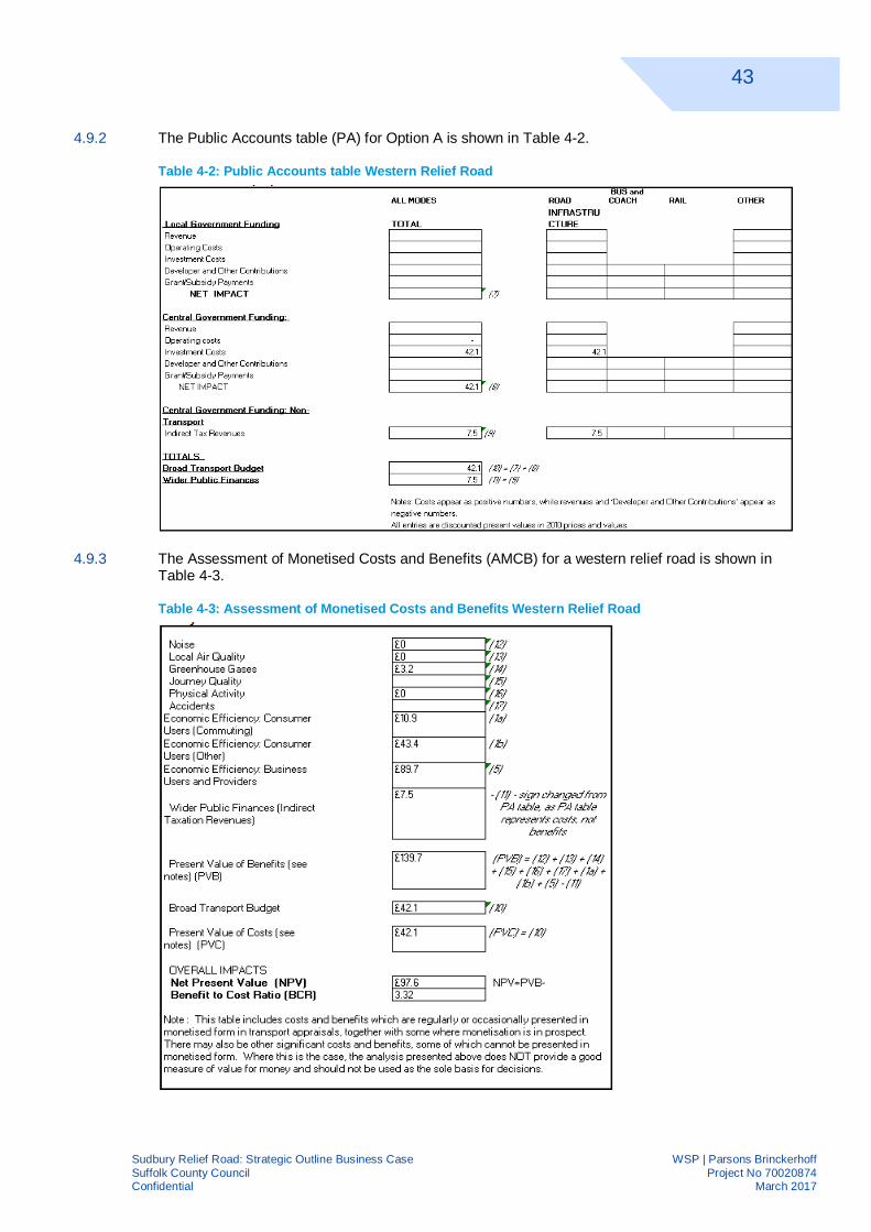
43
Sudbury Relief Road: Strategic Outline Business Case WSP | Parsons BrinckerhoffSuffolk County Council Project No 70020874Confidential March 2017
4.9.2 The Public Accounts table (PA) for Option A is shown in Table 4-2.
Table 4-2: Public Accounts table Western Relief Road
4.9.3 The Assessment of Monetised Costs and Benefits (AMCB) for a western relief road is shown inTable 4-3.
Table 4-3: Assessment of Monetised Costs and Benefits Western Relief Road

44
Sudbury Relief Road: Strategic Outline Business Case WSP | Parsons BrinckerhoffSuffolk County Council Project No 70020874Confidential March 2017
5 FINANCIAL CASE5.1 INTRODUCTION
5.1.1 The Financial case provides a cost estimate and a breakdown of how the scheme will be funded.
5.2 COSTS ASSUMPTIONS
5.2.1 An indicative relief road highway design was used to estimate the construction costs. However, asthe design is still at a very early stage, the costs are only approximate.
5.2.2 The high level costs of the proposed scheme have been produced with costs derived fromSPONS Civil Engineering and Highways 2015 (Unit rates), plus an allowance for inflation to3Q/2016.
5.2.3 Other costs, such as design fees, planning and building control fees, changes to utility services,land purchasing or compensation costs, environmental mitigation, out of hours working and trafficdisruptions were estimated to ensure that the cost included all reasonable costs
5.2.4 The total estimated cost for the project is £39,925,285.
5.2.5 The opening year of the relief road has not been estimated at this time, therefore no attempt hasbeen made to show the final out-turn cost.
5.3 FUNDING SOURCES
5.3.1 The following potential funding sources have been identified:
à Future Department for Transport Local funding streams
à Local Enterprise Partnership Funding
à Local Partners (Babergh District, Braintree District, Essex County Council)
à Suffolk County Council
à Private developers
5.3.2 A full risk evaluation has not been carried out on the project. This will be carried out during anOutline Business Case. A 50% Risk and Contingency allowance has been used to provide arobust assessment.
5.4 FINANCIAL SUSTAINABILITY
5.4.1 Maintenance of additional highway is not likely to pose any undue extra burden on the council.

45
Sudbury Relief Road: Strategic Outline Business Case WSP | Parsons BrinckerhoffSuffolk County Council Project No 70020874Confidential March 2017
6 COMMERCIAL CASE6.1 COMMERCIAL VIABILITY
6.1.1 Suffolk County Council have recently embarked on two major highway schemes and will use theexperienced gained to steer the delivery of the Sudbury relief road.
6.1.2 We believe we understand and have practical experience of the problems we are likely toencounter and have a realistic deliverable project plan to make sure the allocated resources areused on time.
6.2 PROCUREMENT STRATEGY
6.2.1 Following on from output based specification the procurement strategy suggested in this sectionneeds to be managed, developed and recorded in the dynamic context of the development of theproject itself.
6.2.2 This is based on the experience that assumptions made at a point in time may well change duringfuture scheme development. Therefore continually reviewing the baseline and developedassumptions, and crucially being prepared to challenge and change when counterfactualevidence to the assumptions is identified, should result in the procurement being as closelyaligned to the scheme objectives as possible.
6.2.3 It is recognised that the form of procurement itself plays a considerable role in the behaviour andproject culture that is likely to be manifested during the physical delivery of the scheme. This isbased on experience that people and organisations will both take less risk and react negatively orcautiously to issues requiring change and negotiation; if procurement and particularly thecontractual terms and conditions are alien to them.
6.2.4 From this understanding we have taken the view that for a publically procured Civil Engineeringscheme the New Engineering Contract (NEC) family of contracts and it is general proceduresshould be used in the procurement of this scheme for sourcing options 1 to 4 in 6.4. If sourcingoptions 5 and 6 from 6.4. are to be pursued then consideration of the variance between the termsand conditions in these existing framework contracts and the NEC should be undertaken and theimpact evaluated in making a decision on sourcing options.
6.2.5 There are a number of key elements in the development of a successful procurement strategy:
a) Approval by Suffolk County Council, the New Anglia Local Enterprise Partnership and theDepartment for Transport, including the preferred strategy and financial analysis
b) Distillation of client and stakeholder objectives into tangible, measurable and achievableEmployer’s Requirements
c) Timing and type of engagement with Contractors/Providers
d) Assessment of NEC contract options
e) Market engagement and market testing
f) Consideration, Management and mitigation of the prevailing market conditions at the timeof procurement and projected through the contract period

46
Sudbury Relief Road: Strategic Outline Business Case WSP | Parsons BrinckerhoffSuffolk County Council Project No 70020874Confidential March 2017
6.3 IDENTIFICATION OF RISK
6.3.1 The main risk of this scheme is unexpected additional costs either due to errors in the originalcostings or due to unanticipated technical problems.
6.3.2 A 50% risk and contingency budget has been used to provide assurance to the scheme.
6.3.3 Further detailed risk analysis will be undertaken during the Outline Business Case.
6.4 CONTRACT MANAGEMENT
6.4.1 The timescale for delivery is not known at present and allows for resourcing of the procurementand subsequent construction contract management to be undertaken at a later stage.
6.4.2 This core team would be supplemented as necessary from SCC’s professional services supplychain, including, specialist procurement, legal and quantity surveying services.
47
Sudbury Relief Road: Strategic Outline Business Case WSP | Parsons BrinckerhoffSuffolk County Council Project No 70020874Confidential March 2017
7 MANAGEMENT CASE
7.1 INTRODUCTION
7.1.1 This chapter describes how the scheme will be delivered through project management bestpractice, confirming that the timescales are realistic and demonstrating that an appropriategovernance structure is in place to oversee the project.
7.1.2 We have used an industry standard approach but also considered local variations.
7.1.3 The Management Case comprises of the following components:
à Evidence of similar projects;
à Programme and project dependencies;
à The governance structure (management framework);
à The scheme / project scheduling;
à The stakeholder management process;
à The risk management process;
à How the benefits set out in the economic case will be monitored and realised.
7.2 PREVIOUS SCHEME DELIVERY
7.2.1 Suffolk County Council has a proven track record of delivering large infrastructure schemes. Aselection of key schemes have been listed in the table below, summarising the scope of works,capital costs, timescales for implementation and the procurement strategy employed.Opportunities will be taken, wherever possible, to improve delivery processes, through actingupon lessons learnt.

48
Sudbury Relief Road: Strategic Outline Business Case WSP | Parsons BrinckerhoffSuffolk County Council Project No 70020874Confidential March 2017
NO. CONTRACT DESCRIPTION WORKS DATEFORM OF
CONTRACTAPPROXIMATE
VALUE
PROJECTDELIVERED
SUCCESSFULLY
1Suffolk HighwaysServices Contract
Fabrication, construction and installation of a new pedestrianand cycle bridge over the A14 at Bury St Edmunds (ThingoeHill to Northgate Avenue).
April 2014 –September 2014
Through theSupport ServicesContract (NEC)
£1,500,000 Yes
2Suffolk HighwaysServices Contract
Construction of a flood alleviation scheme on the A12 atBlythburgh which included the installation of 800m of steelsheet piling and earth embankments.
May 2014 –September 2014
Through theSupport ServicesContract (NEC)
£800,000 Yes
3 Competitive Tender
The B1115 Stowmarket Relief Road was a major transportscheme consisting of a new road and alterations to the existingStowmarket inner relief road (Gipping Way) to help to relievecongestion around the town centre, and to integrate newdevelopments on the outskirts of the town with the town centre.It also included the provision of a bridge over the Norwich toLondon railway line and removal of a level crossing.
May 2008 –August 2010
NEC Option C £12,000,000 Yes
4
Suffolk HighwaysServices Contract /OGC Framework /
Competitive Tender
‘Ipswich Transport Fit For the 21st Century’ (Travel Ipswichscheme) was an integrated scheme involving:· competitive tender for reconstruction of two bus stations
(Old Cattle Market and Tower Ramparts), one junction andassociated works;
· OGC Framework Contract for provision of VariableMessage Signing and Real Time Passenger Informationsystem;
· Suffolk Highways Services Contract for the modernisationof traffic signal junctions and connection into andimplementation of an Urban Traffic Management andControl system.
The scheme also included a detailed programme of
July 2012 –September 2015
NEC Option Band Through theSupport Services
Contract
£21,000,000 Yes

49
Sudbury Relief Road: Strategic Outline Business Case WSP | Parsons BrinckerhoffSuffolk County Council Project No 70020874Confidential March 2017
NO. CONTRACT DESCRIPTION WORKS DATEFORM OF
CONTRACTAPPROXIMATE
VALUE
PROJECTDELIVERED
SUCCESSFULLYimprovements to walking and cycling routes and crossings inand around the town centre.
5Lowestoft Southern
Relief RoadCompetitive Tender
Construction of a new 3km single carriageway relief road, aswell as 750m of ‘on-line’ widening and other improvements tothe existing carriageway in order to maximise key brownfieldsites to the south of Lake Lothing. It also provides an UrbanTraffic Management and Control (UTMC) system, including:· SCOOT traffic signals;· Bus priority measures;· Real time passenger information;· Variable Message Signing;· Air Quality monitoring.The associated traffic management measures were completedin early 2007, following the construction of the main relief road(Tom Crisp Way) in June 2006.
January 2005 –February 2007
NEC Contract £31,000,000 Yes
6Mutford Lock
Refurbishment(Competitive Tender)
Construction of Mutford Lock lift bridges comprising a 12mspan steel bascule bridge with fixed approach spans on bothapproaches and an 8.6m span timber overhead basculepedestrian bridge, together with associated approach road /junction improvements and reconstruction of adjacent railwaylevel crossing.
1992ICE Conditions of
Contract£6,000,000 Yes
7Eastern Highways
Alliance Framework 1
The Lowestoft Northern Spine Road Phase 5 construction of a1.5km section of single carriageway road with one associatedroundabout connecting in to the Trunk Road network.
July 2014 – March2015
NEC Option B £5,000,000 Yes
Table 7-1: Summary of previous scheme delivery

50
Sudbury Relief Road: Strategic Outline Business Case WSP | Parsons BrinckerhoffSuffolk County Council Project No 70020874Confidential March 2017
7.3 PROGRAMME /PROJECT DEPENDENCIES
7.3.1 The scheme is not reliant on any other schemes happening before or after for it to realise itsbenefits. No other future projects or schemes are dependent on it. It can be delivered, designedand costed independently and can progress in isolation.
7.4 PROJECT GOVERNANCE, ORGANISATION STRUCTURE AND ROLES
7.4.1 The management of the development and delivery of this project is being undertaken by SuffolkCounty Council as the lead authority.
7.4.2 PRINCESS, a specifically modified version of PRINCE2 will be used.
7.4.3 PRINCESS helps to apply best practice and supports good decision making to projects in Suffolk.
7.4.4 A well-functioning governance structure will be crucial to the successful delivery of the scheme.Suffolk County Council will therefore establish a Project Board, a Project Delivery Team and aStakeholder Group to work together to deliver the scheme.
7.4.5 The Project Board’s primary function is decision-making and review, and will provide strategicgovernance, as opposed the technical input of the Delivery Team. The Board will be responsiblefor:
à Managing the scheme and ensuring its successful delivery;
à Keeping track of the contractor’s adherence to the project programme and completion ofmilestones, to ensure that the scheme is delivered within the constraints of time and budget;
à Providing guidance and support to the Project Manager;
à Authorising necessary funds and spending (to the Contractor);
à Stakeholder management; and
à Managing risks (a shared responsibility with the contractor).
7.4.6 The Programme Board will meet on a monthly basis and will be responsible for:
à Providing direction to ensure the success of the project in terms of the right activities, withinbudget, on time and to the correct quality standards;
à Ensuring sufficient resources are allocated to the programme;
à Providing direction and guidance on issues brought forward by the Programme Manager;
à Taking account of risks and their impact on achieving the scheme objectives;
à Approving (and where necessary requesting) changes to the programme managementprocedures, project plans and project deliverables;
à All publicity and dissemination of information about the project to an external audience; andformal closure of the project.
7.4.7 The design of the Scheme is to be undertaken by consultants through Suffolk County Council’ssupply chain partners for the provision of professional services. This will ensure that there isongoing specialist expertise available, which will be vital for the successful implementation of theproject.
7.4.8 The proposed governance structure for this project is shown below:

51
Sudbury Relief Road: Strategic Outline Business Case WSP | Parsons BrinckerhoffSuffolk County Council Project No 70020874Confidential March 2017
MEMBER KEY ROLES AND RESPONSIBILITIES RESOURCEDProject Director
SeniorResponsibleOwner
Responsible for delivering the new capabilities through themanagement (planning and monitoring) of the project.
Geoff Dobson, Director of ResourceManagement, Suffolk CountyCouncil
Corporate financialmanager
Responsible for managing the project budget, monitoringexpenditures and costs throughout the project.
Tracey Woods, Chief Accountant(Financial Control), Suffolk CountyCouncil
Senior Supplier Responsible for the accountability of the quality ofdeliverables produced by the design consultants.
Jerry Pert, Kier Group (SuffolkHighways)
New Anglia LocalEnterprisePartnership
New Anglia Local Enterprise Partnership representativeChris Starkey, Managing Director,New Anglia Local EnterprisePartnership
CommunicationsLead
Responsible for communication and stakeholderengagement
Adam Barnes, Senior StrategicCommunications Officer, SuffolkCounty Council
Project Director
Responsible for the delivery of a product that is relevant, tothe required standard of quality within the specifiedconstraints of time and costResponsible for project delivering benefits defined inbusiness case
Dave Watson, Suffolk CountyCouncil
Principal Designer
Design TeamDirector
Responsible for ensuring the production of the productdefined by the project director. Delivering a qualityproduct on time and to budget
To be appointed
Design TeamManager
Responsible for managing the multi-disciplinary team todeliver a quality product on time and to budget. To be appointed
Other Roles
EnvironmentalOfficer
Responsible for ensuring the project adequately considersand mitigates its environmental impact.
Nick Collinson, Head of Natural andHistoric Environment, SuffolkCounty Council
Transport Policy Responsible for ensuring the project fits with SuffolkTransport Policy
Graeme Mateer, Transport PolicySpecialist, Suffolk County Council
Economic Policy Responsible for ensuring the project fits with SuffolkEconomic Policy
Mike Dowdall, EconomicDevelopment Manager, SuffolkCounty Council
Project Assurance Provides an independent review of project progress TBCTable 7-2: Key roles and responsibilities

Appendix ATABLE OF DEVELOPMENTS

Site No.Planning app
reference number District Council Development Address DescriptionResidential(dwellings)
Business(floorspace
m2)Reatil and Commercial
floorspace (m2)Mixed use
(m2) Status
1 N/AIpswich Borough
Council Cornhill RegenerationThe project by the Ipswich Vision Group aims to inject new life and
business into the heart of the town. UnknownCommitted
development
2 c/08/0500 Suffolk Coastal
Land south of Martinsyde,Beardmore Park,
Martlesham heath,Martlesham.
Erection of non-food retail unit comprising 2, 839sqm buildling & 734sqmexternal trade yard (3,573sqm total), with car parking & associated
landscaping. 3,573Committed
development
3 DC/15/2004/RG3Suffolk Coastaland Waveney Former Sanyo factory site
Outline Application for up to 252 residential units (Class C3) andassociated infrastructure; and Full Application for development of 48
residential units, 2 hectares of community open space includingreplacement dual-purpose football pitch, changing facilities and equiped
play area, associated highway, engineering and landscaping works,including land raising, relocation of existing pumping station and
temporary use of part of site for surface level car park associated with thecommunity open space. 300
Committeddevelopment
4 C/07/0362 Suffolk CoastalLand North Side of Church
Hill, SaxmundhamConstruction of 145 dwellings including 49 affordable units with
associated access and the provisions of public open space. 145Committed
development
5 C12/0068/FUL Waveney
Land Between Orford Road,Langer Road and ManorTerrace, South Seafront,
FelixstoweConstruction of maritime park to include play areas, gardens, toilets and
public car parking together with 158 dwellings. 158Committed
development
6 B/06/01488/OUT Barbegh
Land South of Lady Laneand North of, Tower Mill
Lane, Hadleigh, Development of up to 170 dwellings, 5 hectares of industrial/commerical. 170 50,000Committed
development
7 SE/09/1283 Edmundsey Land at North West Haverhill 1,150 Residential units, a primary school and local facilities. 1,150Committed
development
8 12/01472/FUL Braintree
Land at Highfieilds Farm,Highfields Lane, Kelvedon
EssexConstruction of a 36.54hectare solar park, to include the installation of
solar panels to generate electricity. 360,000Committed
development
9 15/00582/FUL Braintree
Land North of A131 AvenueEast, Skyline 120, Great
Notley, EssexErection of 18 units for B1, B2 and B8 uses along with ancilliary service
yards, car parking, cylcle and motor cycle parking. 6,290Committed
development
10 15/00799/OUT BraintreeLand at North East, WithamForest Road, Withim, Essex Application for 222 residential dwellings. 222
Committeddevelopment
11 14/01580/OUT BraintreeLand south of Oak road
Halstead, Essex Application for the erection of up to 292 residential dwellings. 292Committed
development
12 06/01143/OUT Braintree
Land on the south side ofMaltings Lane, Witham,
Essex Erection of 268 residential dwellings, B1 business park, school 268Committed
development
13 N/A BaberghFormer Brett Works,
Hadleigh 3.7ha of land allocated for retail use. 37,000
Land allocatedin DevelopmentPlan Document
14 N/A BaberghLand to East of Sudbury /
Great Cornard Land allocated for employment or residential land use.
Land allocatedin DevelopmentPlan Document
15 N/A Babergh Eye Airfield Land allocated for employment or residential land use.
Land allocatedin DevelopmentPlan Document
16 N/A BaberghLand North of Anglia
Business Park - Whitton Land allocated for Ccommercial and / or employment
Land allocatedin DevelopmentPlan Document
17 c/09/0555 Suffolk CoastalAdastral Park, Martlesham
Heath, Martlesham
Refurbishment of Adastral Park and development of adjoining land toprovide:up to 60, 000 m2 additional employment floorspace (B1); erectionof up to 2000 dwellings: mixed-use local centre; education; hotel; energy
centre;public park. 2,000 60,000Proposed
development
18 B/15/01718 Babergh
Chilton Woods- Land northof, Woodhall Business Park,
SudburyApplication for 1,100 residential dwellings, general industrial, storage and
distribution uses office development. 1,100 61,670Proposed
development
19 B/15/00673 BaberghLand north west of, Moores
Lane, East BergholtErection of 144 dwellings including 360sqm of courtyard development to
contain 4 B1 units and public open space. 144 360Proposed
development
20 15/01319/OUT BraintreeLand West of Panfeild Lane,
Braintree, EssexApplication for a mixed use development, which includes, 600 residential
dwellings. 600Proposed
development
21 15/01193/FUL Braintree
Land between London Roadand East of Pods BrookRoad Braintree Essex
Erection of 215 residential dwellings and new vehicular access fromLondon Road. 215
Proposeddevelopment
6764 487960 90573 360

Appendix BAPPRAISAL SUMMARY TABLE
Babergh and Mid Suffolk District Councils (2015) Joint Babergh and Mid Suffolk District CouncilLandscape Guidance i

Appraisal Summary Table Jan-17
Name Marc ThomasOrganisation WSP | PBRole Associate Director
Summary of key impactsMonetary Distributional
£(NPV) 7-pt scale/vulnerable grp
£43
Reliability impact on Businessusers
There is a reliability benefit as a result of congestion relief, journey time becomes more predicable.£90
Regeneration No negative or positive impacts identified N/AWider Impacts No negative or positive impacts identified N/ANoise The operation of the bypass has the potential to have an adverse effect on noise sensitive receptors within 300m of the
scheme. Receptors are likely to include Kitchen Farm, dwellings at Kitchen Hill, New cottages, Barley Mill cottage and dwellingson Melford Road. On the other hand, a reduction in traffic flows on the A131 going through Sudbury is likely to result in areduction in noise levels for those propertis adjacent to the main road.
Air Quality A relief road would likely result in an overall benefit to air quality. NO2 concentration reductions are anticipated within theAQMA, as well throughout the town of Sudbury.Disbenefits to air quality are anticipated within 200m of a relif road, however there are very few (<10) human receptors, and nostatutory designated ecological sites, within this area.
Landscape The development of a relief road is likely to adversely affect the special qualities of designated landscapes nearby. It wouldalso adversely affect the cultural associations with Gainsborough, particularly on views from Auberies. The introduction ofengineered landforms would be at variance with the natural landform, and the loss of hedgerows would adversely affect thehistoric field pattern. Due to the likely large visual influence it is likely to cause adverse effects on views and visual amenityfrom surrounding sensitive visual receptors. The area’s strong sense of tranquillity would also be adversely affected due toincreased traffic, noise and visual appearance of the scheme. Considering the high sensitivity of much of the landscape andvisual resource and the likely high magnitude of change, the level of effect is considered to be Large adverse overall.
Townscape N/AHistoric Environment The development of a relief road is likely to be intrusive in the settings of 23 assets and will affect the appreciation and
understanding of the historical associations and functions of the assets. The setting of two historic landscapes and SudburyConservation Area are also likely to be adversely affected by a relief road. However, a relief road is expected to have abeneficial impact on the experience within Sudbury Conservation Area. A relief road could also have direct physical impact onthe remains of known non-designated assets although adequate mitigation can be specified. Additionally, there is a highpotential for previously unrecorded buried archaeology from the prehistoric to the modern period to be present.
Biodiversity The relief road could cause significant impacts to a variety of ecological features including the Railway Walks Local NatureReserve and the River Stour and Associated tributaries though habitat loss, degradation and fragmentation. Survey dataregarding the populations of notable and protected fauna is not available at this stage, however based on the habitats presentit is reasonable to conclude that a range of species will be present including bats (roosting and foraging), birds (overwinteringand breeding), reptiles, amphibians, otter and water vole. The impacts of habitat fragmentation and lighting upon thesespecies may be significant.
Water Environment A relief road would cross over two main rivers, the River Stour and Betchamp Brook, and an ordinary watercourse to the eastof the Auberies Estate lake. Loss of natural channel bed and bankside habitat could affect the hydromorphological quality ofthe watercourses and connectivity along the watercourse. A relief road on embankment within the floodplain of the River Stourcould also have a notable effect on the wetland value of this floodplain. A relief road would pass through the fluvial floodplainassociated with the River Stour and Betchamp Brook. Restricting flood flow conveyance could have significant impacts to floodrisk upstream of the scheme. This is particularly significant for a relief road on embankment that passes through the floodplainof the River Stour.
£90
Reliability impact onCommuting and Other users
There might be reliability benefit as a result of congestion relief, journey time becomes more predicable. This has not beenassessed in detail. £10.90
Physical activity No negative or positive impacts identifiedN/A
Journey quality Journey quality may be improved from a new wider Relief Road, and reduced congestion on the road. This has not beenassessed in detail. N/A
Accidents The scheme will result in a reduction in PIA's.£4.50
Security The level of security for road users on the Relief Road and those remaining in the town centre will be improved.N/A
Access to services No negative or positive impacts identifiedN/A
Affordability No negative or positive impacts identifiedN/A
Severance No negative or positive impacts identifiedN/A
Option and non-use values No negative or positive impacts identifiedN/A
Cost to Broad TransportBudget £42.10
Indirect Tax Revenues There is a minor revenue benefit on indirect taxations from fuel sale, as more road traffic would be attracted.£7.50
Envi
ronm
enta
l
Business users & transportproviders
Econ
omy
The Relief Road is expected to largely resolve the congestion problems in the town, and provide journey time saving benefit forthough traffic as well as road users on the current town centre route.
The TUBA result indicates a decrease of greenhouse gas emissions across the study area and an overall Greenhouse GasBenefit.
Greenhouse gases
Impacts
Name of scheme:Description of scheme:
Value of journey time changes(£)
An indicite Western Relief Road has been proposed to the West of Sudbury with a length of 3.5km including 6 bridges, 2 underpass drains, 3 junctions and 2 underpass accesses. The Relief Road commences from the Sudbury Road / Melford Road / A134 roundabout and meets the A131 to the South.
AssessmentQualitative
Sudbury Relief Road
Net journey time changes (£)
£0 £43
£43.40
Quantitative
2 to 5min > 5min£0
Assessed based on economic efficiency
0 to 2min
Assessed based on economic efficiency
Value of journey time changes(£)
0 to 2min 2 to 5min
An indicative quantitative assessment has been undertaken only doing a highlevel review of the traffic data. Thetraffic forecast suggests that the A131 through town will observe a reduction in traffic flows of 30 to 40% in theyear 2021. This has the potential to reduce the noise climatefor those properties by 2 dB.
Net journey time changes (£)
Neutral
A high level assessment has been undertaken to determine the likely noise impact. It is considered thatsensitive receptors in the town centre are likely the subject to a minor beneficial impact. On the otherhand, receptors near the relief road may be subject to a moderate adverse impact, although mitigationmay reduce this.The risk on the number of dwellings eligible under the Noise Insulation Regulations1975, as amended 1988, is low.
Neutral
Change in traded carbon over 60y (CO2e)Change in non-traded carbon over 60y (CO2e)
Date produced: Contact:
£0 £90 £0
£89.70
£717,000
Beneficial
Not assessed in detail
Large Adverse
Not assessed in detail
Neutral
Moderate Beneficial
Large Beneficial
Neutral
Neutral
Neutral
Slight Beneficial
Neutral
Large Adverse
Moderate Adverse
Large Adverse
Publ
icA
ccou
ntSo
cial
Not assessed in detail
Not assessed in detail
Estimated based on increased vehicle kilometres
Capital investment on constructing the Relief Road.
Not assessed in detail
Not assessed in detail
Assessed based on the previous study.
Not assessed in detail
Not assessed in detail
Commuting and Other users The Relief Road is expected to largely resolve the congestion problems in the town, and provide journey time saving benefitfor
though traffic as well as road users on the current town centre route. > 5min
Not assessed in detail