Embed Size (px)
Citation preview
Report No 158
Navigation Act 1912Navigation (Marine Casualty) Regulations
report of the investigation intothe grounding of the Kuwaiti flag product tanker
Al Deerahat Garden Island in the Tamar River, Tasmania
on 30 April 2000
Issued by the
Australian Transport Safety Bureau
September 2001
ISBN 0 642 20041 6
Investigations into marine casualties occurring within the Commonwealth's jurisdiction areconducted under the provisions of the Navigation (Marine Casualty) Regulations, madepursuant to subsections 425 (1) (ea) and 425 (1AAA) of the Navigation Act 1912. TheRegulations provide discretionary powers to the Inspector to investigate incidents as defined bythe Regulations. Where an investigation is undertaken, the Inspector must submit a report tothe Executive Director of the Australian Transport Safety Bureau (ATSB).
It is ATSB policy to publish such reports in full as an educational tool to increase awareness ofthe causes of marine incidents so as to improve safety at sea and enhance the protection of themarine enviroment.
To increase the value of the safety material presented in this report, readers are encouraged tocopy or reprint the material, in part or in whole, for further distribution, but shouldacknowledge the source. Additional copies of the report can be obtained from:
Inspector of Marine AccidentsAustralian Transport Safety BureauPO Box 967Civic Square 2608 ACT
Phone: 02 6274 60881800 621372
Fax: 02 6274 6699Email: [email protected] address: www.atsb.gov.au
ii
iii
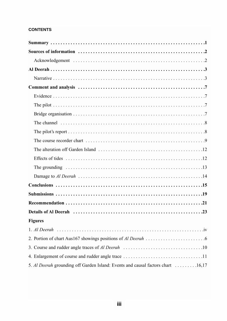
CONTENTS
Summary . . . . . . . . . . . . . . . . . . . . . . . . . . . . . . . . . . . . . . . . . . . . . . . . . . . . . . . . . . . . . .1
Sources of information . . . . . . . . . . . . . . . . . . . . . . . . . . . . . . . . . . . . . . . . . . . . . . . . . . .2
Acknowledgement . . . . . . . . . . . . . . . . . . . . . . . . . . . . . . . . . . . . . . . . . . . . . . . . . . . . .2
Al Deerah . . . . . . . . . . . . . . . . . . . . . . . . . . . . . . . . . . . . . . . . . . . . . . . . . . . . . . . . . . . . . .3
Narrative . . . . . . . . . . . . . . . . . . . . . . . . . . . . . . . . . . . . . . . . . . . . . . . . . . . . . . . . . . . . .3
Comment and analysis . . . . . . . . . . . . . . . . . . . . . . . . . . . . . . . . . . . . . . . . . . . . . . . . . . .7
Evidence . . . . . . . . . . . . . . . . . . . . . . . . . . . . . . . . . . . . . . . . . . . . . . . . . . . . . . . . . . . . .7
The pilot . . . . . . . . . . . . . . . . . . . . . . . . . . . . . . . . . . . . . . . . . . . . . . . . . . . . . . . . . . . . .7
Bridge organisation . . . . . . . . . . . . . . . . . . . . . . . . . . . . . . . . . . . . . . . . . . . . . . . . . . . . .7
The channel . . . . . . . . . . . . . . . . . . . . . . . . . . . . . . . . . . . . . . . . . . . . . . . . . . . . . . . . . .8
The pilot’s report . . . . . . . . . . . . . . . . . . . . . . . . . . . . . . . . . . . . . . . . . . . . . . . . . . . . . . .8
The course recorder chart . . . . . . . . . . . . . . . . . . . . . . . . . . . . . . . . . . . . . . . . . . . . . . . .9
The alteration off Garden Island . . . . . . . . . . . . . . . . . . . . . . . . . . . . . . . . . . . . . . . . . .12
Effects of tides . . . . . . . . . . . . . . . . . . . . . . . . . . . . . . . . . . . . . . . . . . . . . . . . . . . . . . .12
The grounding . . . . . . . . . . . . . . . . . . . . . . . . . . . . . . . . . . . . . . . . . . . . . . . . . . . . . . .13
Damage to Al Deerah . . . . . . . . . . . . . . . . . . . . . . . . . . . . . . . . . . . . . . . . . . . . . . . . . .14
Conclusions . . . . . . . . . . . . . . . . . . . . . . . . . . . . . . . . . . . . . . . . . . . . . . . . . . . . . . . . . . .15
Submissions . . . . . . . . . . . . . . . . . . . . . . . . . . . . . . . . . . . . . . . . . . . . . . . . . . . . . . . . . . .19
Recommendation . . . . . . . . . . . . . . . . . . . . . . . . . . . . . . . . . . . . . . . . . . . . . . . . . . . . . . .21
Details of Al Deerah . . . . . . . . . . . . . . . . . . . . . . . . . . . . . . . . . . . . . . . . . . . . . . . . . . . .23
Figures
1. Al Deerah . . . . . . . . . . . . . . . . . . . . . . . . . . . . . . . . . . . . . . . . . . . . . . . . . . . . . . . . . . .iv
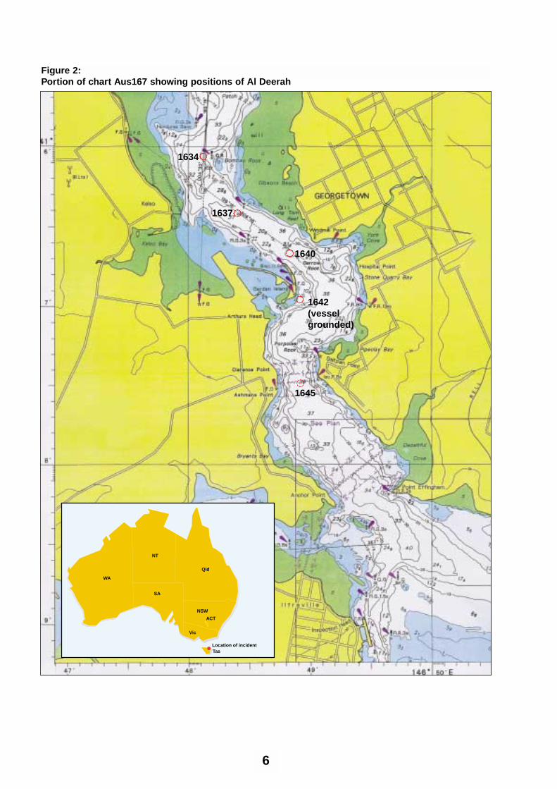
2. Portion of chart Aus167 showings positions of Al Deerah . . . . . . . . . . . . . . . . . . . . . . . .6
3. Course and rudder angle traces of Al Deerah . . . . . . . . . . . . . . . . . . . . . . . . . . . . . . . .10
4. Enlargement of course and rudder angle trace . . . . . . . . . . . . . . . . . . . . . . . . . . . . . . . .11
5. Al Deerah grounding off Garden Island: Events and causal factors chart . . . . . . . . .16,17
iii

iv
Fig
ure
1:
Al D
eera
h
SummaryOn the afternoon of 30 April 2000, theKuwaiti flag product tanker Al Deeraharrived off the Tamar River. The tanker wascarrying a cargo of gas oil, heating oil andunleaded petrol from Kwinana in WesternAustralia for discharge at Bell Bay and otherAustralian ports.
At 1600 a pilot embarked to conduct theship to the oil berth in Bell Bay. On thebridge with the pilot were the master, themate and a helmsman on the wheel. Thetide was flooding at an estimated two knots.Shortly after boarding, the pilot ordered fullahead manoeuvring speed.
The passage through the entrance of theTamar River is narrow and there are sevensignificant alterations of course within adistance of 5.51 miles. As the vessel enteredthe Tamar River and made the initial coursealterations, the pilot found that the ship wassluggish to respond to the rudder. Later, onthe Stone Quarry leads, significant angles ofcounter rudder were required to steady thevessel on course.
At about 1637 the vessel steadied on theStone Quarry leads, approaching the wheel-over position to alter towards the south offGarden Island. At about 1639 the pilotordered starboard rudder to bring the ship tothe next heading. As the vessel alteredcourse to starboard the pilot realised that itwas turning too quickly. He ordered therudder amidships, then to port. However, thevessel continued swinging to starboard,
making contact with the bottom off thesoutheast edge of Garden Island. It heeled toport, then returned upright before listing tostarboard.
Al Deerah’s cargo tanks are protected byballast tanks and a check revealed that nos.2 and 3 starboard combined bottom and sideballast tanks were filling with water. Themaster ordered that the port ballast tanks befilled to counteract the list.
At 1745, the vessel anchored in Bell Bay.The harbour master boarded the vessel todiscuss the situation with the master and thepilot. He disembarked after deciding that itwas safe to berth the vessel and Al Deerahwas secured at its berth at 2215 withoutfurther incident.
Nobody was hurt as a result of thegrounding, nor did any oil or other pollutantescape from the ship.
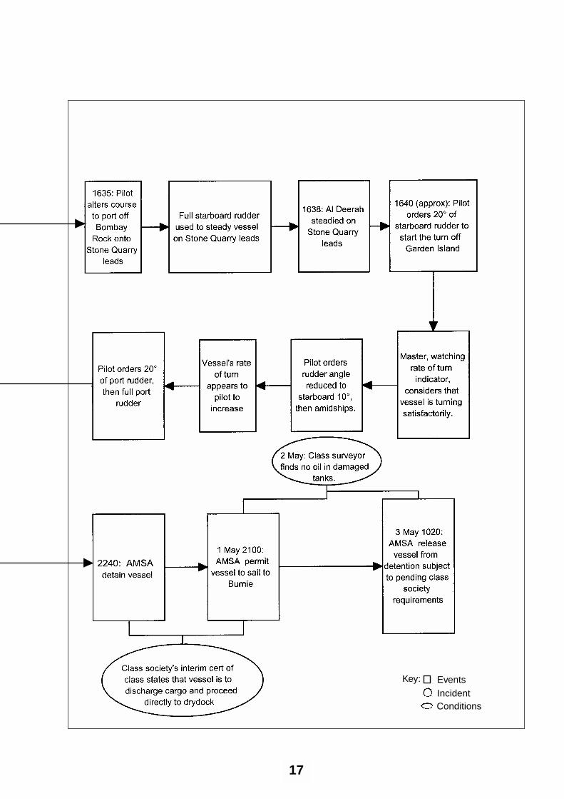
The Australian Maritime Safety Authority(AMSA) detained the vessel at 2240 on 30April. The detention was lifted at 2100 on 1May to permit the vessel to sail to Burnieafter a classification society surveyor hadviewed video footage of an underwaterexamination of the hull and had issued thevessel with a condition of class. The interimcertificate from the class society stated thatthe vessel was to discharge its cargo atBurnie and Port Botany, then proceeddirectly to dry dock for repairs.
After discharging its cargo at Bell Bay, AlDeerah left the berth and anchored at BellBay at 0034 on 2 May, before sailing forBurnie at 0908 the same day.
1
1Miles refers to nautical miles (one nautical mile = 1852 metres)
Sources ofinformationMaster and crew of Al Deerah
The pilot
The harbour master, Port of LauncestonAuthority
Lloyd’s Register of Shipping
Australian Maritime Safety Authority
The Shiphandler’s Guide, (First edition1996), Captain R W Rowe, FNI
Acknowledgement The Simulation Manager, AustralianMaritime College
2
Al DeerahAl Deerah is a Kuwaiti flag product tankerowned by Kuwait Oil Tanker Co. (S.A.K.).At the time of the incident, the vessel wason time charter to D S Norden of Denmarkand was on spot charter to BHP for avoyage from Kwinana to Bell Bay, Burnieand Port Botany.
The vessel, built in 1989 by SamsungShipbuilding & Heavy Industries Co Ltd inKoje, South Korea, is of double hullconstruction and is classed with Lloyd’sRegister of Shipping. It has a gross tonnageof 26 356, a net tonnage of 8 643 and asummer deadweight of 35 643 tonnes at adraft of 11.28 m. It is 182.9 m in lengthoverall, has a moulded depth of 16.5 m anda beam of 32.2 m. The accommodation andthe machinery space are aft. The vessel,fitted with an inert gas system, has 8 centretanks for cargo and five segregated ballasttanks which form the double hull around thecargo tanks.
Al Deerah is powered by a 5-cylinder B&W5L60MC diesel engine developing 6 716 kW driving a single shaft and a fixedpitch propeller. The ship has a service speedof 13.5 knots. The engine room is operatedas UMS (Unmanned Machinery Spaces).
The ship is equipped with the normal rangeof navigation equipment including 2 DGPS(differential GPS) receivers, fore and aftecho sounders, two radars and a rate of turnindicator. The bridge and chartroom arecombined.
Al Deerah has International SafetyManagement (ISM) accreditation, its ISMCertificate being issued by Lloyd’s Register.
At the time of the incident, the ship had 27crew, 25 of Bulgarian and 2 of Indian
nationality. The master had been at sea, ontankers, for 30 years. He had been with thecompany since 1982 and had sailed as 2nd
mate and as mate before gaining commandin 1993. The mate had 10 years experienceas mate, the last two years with the ownersof Al Deerah.
Narrative Al Deerah arrived at the pilot boardingground for the River Tamar at 1500 on 30 April and drifted until the pilot boarded.The vessel, inbound for Bell Bay, wasloaded with gas oil, heating oil and unleadedpetrol from Kwinana in Western Australia.The draft was 9.38 m forward and 10.08 maft.
The 2nd mate had drawn courses for the riverpassage as far as Bombay Rock. The pilotboarded at 1600 and provided the masterwith the passage plan from the pilotboarding ground to the berth.
Notes on the pilot’s plan stated that thecourses steered would vary from thoseshown depending on the type and size ofvessel, including draft and speed, thehandling characteristics and the influence ofthe weather and current. The master gave thepilot a pilot card with the required details ofthe ship on it. About ten minutes later, theengine was put to ‘full ahead manoeuvring’revolutions and the vessel proceeded inwardon a flood tide.
The pilot was aware from the ship’s pilotcard that, at full ahead manoeuvring, theengine revolutions (rpm) were supposed tobe 75. The tachometer was indicating 66 rpm and the pilot brought this to themaster's attention, asking for morerevolutions. The rpm increased to 75 shortlyafter this.
The vessel was on manual steering and themate, who was on the bridge for the passage
3
in the river, was monitoring the vessel’sinward progress. He was plotting positionsusing bearings and radar distances offbeacons and, later, also using landmarks. Inaddition, he was watching the echosounders, advising the master of changes ofdepths. It was the master’s first time in theriver and he was making notes on thepassage inward.
The vessel entered the river just after 1616and was off Middle Bank at 1621. At 1624the vessel passed Shear Rock and at 1634 itwas just north of the alteration off BombayRock. The speed made good up to this pointwas 10.9 knots.
The pilot had found that the vessel wassluggish to start turns. He attempted somecourse alterations to position the vessel onleading lines using 10° of rudder. He foundthat if this was done early enough, heobtained the required result. If he requiredthe vessel to turn faster, he used 20° ofrudder to start the turns before easing therudder to 10°.
The pilot found that the bridge team gavehim adequate support. He was aware that themate was plotting positions on the chart. Hewas also aware that the master was makingnotes on what seemed to be the progress ofthe passage.
The predicted time of low water atGeorgetown was at 1406 with a height of0.88 metres. Bell Bay Control informed thepilot that the height on the tide gauge at BellBay was 1.5 metres, confirming to him thatthe vessel had adequate underkeel clearance.
At 1637, Al Deerah was on a heading of140°, coming to the required heading of126° on the Stone Quarry leads. After thecourse had been altered to port off BombayRock, the pilot found that full starboard
rudder was required to steady the vessel onthe Stone Quarry leads. He also found thatlarge amounts of starboard rudder wererequired to hold the vessel on the leads.
At 1640 the mate plotted a positionindicating that the vessel was south west ofWindmill Point, just south of the StoneQuarry leads.
The pilot estimated that the tide was asternat the time at about 2 knots. He ordered 20°of starboard rudder to start the vesselturning off Garden Island. The master,watching the rate of turn indicator, thoughtthat the vessel was turning satisfactorily.
The pilot ordered the rudder angle reducedto starboard 10°, before ordering itamidships. As the vessel turned off theisland, its rate of turn to starboard seemed tohim to increase. The pilot ordered counterrudder of port 20° and, almost immediatelythereafter, hard to port. Despite this, the shipcontinued swinging to starboard. Al Deerahclosed on Garden Island, making contactwith the bottom off the south east edge ofthe island at 1642.
The mate plotted a position off GardenIsland on the ship’s chart at this time. Thedistance off the island, measured from theside of the ship, was about 60 metres.
Al Deerah heeled about 4° or 5° to port,then returned upright. The vessel continuedon at full speed, listing to starboard and, asit finally came round to port, the heel tostarboard increased.
The pilot notified Bell Bay Control of theincident and requested the pilot launch tocheck for any oil leaking from the ship,while the master ordered a check of theballast tanks. The master also ordered the2nd mate, at aft stations, to see if there was
4
any oil from the ship in the river, whereuponhe received a report that there was no oiloutflow.
The pumpman sounded the tanks and foundthat there was water flooding into nos. 2 and3 starboard combined bottom and sideballast tanks. The mate checked tank gaugeson the bridge, estimating that no. 2 tank wasfilling at the rate of about 2 000 tonnes perhour and no. 3 tank was filling at about 600 tonnes per hour.
The master ordered nos. 3, 4 and 5 portballast tanks to be filled by gravity to bringthe vessel upright. At 16451/2, just south ofAshmans Point, the engine was put to halfahead. Two tugs had been standing by atSawyer's Point and, at 1700, in the vicinityof the Bell Bay Beacons, both tugs weremade fast to the ship for the passage to theanchorage. At 1753, after the vesselanchored in Bell Bay, the tugs were cast off.
At 1800, the harbour master boarded thevessel to discuss the situation with themaster and the pilot. The master informedhis owners of the grounding and, afterdiscussions with the owners and the harbourmaster, it was decided that it was safe toberth the vessel. The vessel was upright bythen and the drafts were recorded as 11m
forward and 10.85m aft. The harbour masterdisembarked at 2033, the anchor wasweighed at 2054 and, with tug assistance,the vessel berthed at 2215 at no. 4 berth todischarge its cargo.
The Australian Maritime Safety Authority(AMSA) detained the vessel at 2240 on 30 April. The classification societyinspected the vessel, determining the extentof damage with the assistance of underwaterfootage obtained by a diver. The vessel wassubsequently issued with a condition ofclass. The interim certificate of class statedthat the vessel was to discharge itsremaining cargo at Burnie and Port Botanybefore proceeding directly to drydock forpermanent repairs. At 2100 on 1 May,AMSA lifted the detention order andpermitted the vessel to sail to Burnie. Thevessel sailed from Bell Bay at 0908 on 2 May.
On 2 May, the water in the damaged tankswas examined by a class surveyor whofound no trace of oil contamination. Thevessel was unconditionally released fromdetention by AMSA at 1020 on 3 May, withthe proviso that any pending class societyrequirements were to be met.
5
6
1645
1642 (vesselgrounded)
1640
1637
1634
Figure 2:Portion of chart Aus167 showing positions of Al Deerah
ACT
NSW
NT
Qld
WA
SA
Vic
Tas
NT
NSW
ACT
Location of incident
Comment andanalysis
Evidence An investigator from the AustralianTransport Safety Bureau (ATSB)interviewed the master, the mate, 2nd and 3rd
mates, the radio officer and the helmsmanwho had been at the wheel at the time of thegrounding. The interviews were conductedwhile the vessel was berthed at Bell Bay on1 May 2000. The pilot was interviewed on 4May 2000.
The following documents were obtained toassist with the investigation:
• A copy of the vessel’s chart of theTamar River with positions and timesfor the inward passage
• Copies of relevant pages of the deck logand bell book
• A copy of the pilot’s passage plan
• The vessel’s passage plan as far south inthe river as Bombay Rock
• The vessel’s pilot card
• The pilot’s report to the harbour master
• A copy of the data logger for the enginetelegraph
• The course recorder chart with rudderangle indication
• Copies of fore and aft echo soundergraphs
• The general arrangement and midshipsection plans.
The pilotThe pilot was an experienced seafarer. Hefirst went to sea as an apprentice with theAustralian National Line (ANL) in 1962. Heobtained a 2nd mate’s certificate ofcompetency in 1966, a mate’s certificate in1968 and a master’s certificate in 1971. Heremained at sea until 1973, by which timehe was sailing as mate. From 1973 until1979 he was a nautical officer with theNavigation and Survey Authority inTasmania.
In March 1979, he was appointed assistantharbour master/pilot at Devonport, aposition which he held for about 6 years.His next position was assistant harbourmaster/pilot at Gladstone, from 1985 until1987, where he mainly handled bulk carriersup to 300 metres in length and 17 metresdraught.
He returned to Devonport as harbour masterin 1987 and, in 1989, obtained a licence forthe Tamar River from Long Reach to BassStrait. He became a full-time pilot in theTamar in 1998.
Bridge organisationAfter the pilot boarded, the master and heexchanged information in respect of theship’s details and the plan for the passageinwards, as well as the berthingarrangements.
The pilot found that the bridge equipmentwas operating satisfactorily and that thebridge teamwork was of a high standard.The master was attentive to the navigationof the vessel and the mate plotted frequentpositions on the chart. The helmsmanunderstood the pilot’s orders and, accordingto the pilot, appeared competent. In generalthe bridge organisation conformed withrecognised practice.
7
The channelThe pilotage, from the boarding ground toBell Bay, is about 11 miles in length. Mostof the passage is in a narrow channelbetween the east and west banks of theTamar River. From the mouth of the river,there are seven alterations of course in thechannel as far south as Point Effingham, adistance of about 5.5 miles. The channel isabout 280 m wide at the entrance and has aminimum width of about 210 m.
About three miles into the channel, inboundships alter course to port off Bombay Rock,through almost 60°, to bring the StoneQuarry leading marks into transit. This legof the passage, from settling on course tothe wheel-over position off Garden Island, isjust over half a mile in length. Off GardenIsland, where the channel width betweenGarden Island and Garrow Rock is about250 m, ships make an alteration to starboardof about 90°.
The pilot’s reportThe pilot’s report to the harbour master afterthe grounding contained details of thepassage from the time that he boarded AlDeerah until he anchored the vessel at BellBay anchorage after the incident.
The following are extracts from that report:
I boarded the vessel at approx. 1600 hours in thevicinity of the Pilot Boarding Ground. Theweather was North Westerly 20 knots withoccasional rain squalls.
During the usual alterations of course to put thevessel on the Entrance leads, the steering wassluggish. Further south in the river, turning toport off Bombay Rock, it was noted that thesteering was sluggish, but consistent with herform and proportion and the stated draught…
The alteration of course round the Shear ReefBeacon was carried out normally, although it
was noted that if I had delayed the alteration Iwould have needed extra starboard helm whichwould have resulted in considerably morecounter helm to settle the vessel on her newcourse to pass NW Bank beacon.
Rounding Bombay Rock, I took into accountthese handling characteristics, but still required aconsiderable period of hard to starboard helm tosettle the vessel on to the Stone Quarry leads. Icommenced the turn to starboard at about theusual position for a vessel of that type. Mydistance off the island was also normal. Ireduced the helm from starboard 20 to starboard10, then midships, as I could see that the floodtide run off from the northern end of the islandwas going to continue the starboard swingwithout the starboard helm. This proved to bethe case.
About halfway round the island the rate of turnto starboard appeared to increase slightly. Iapplied port 20 helm and almost immediatelyapplied full port helm. Full port helm wasmaintained for approx. 45 seconds before 1642hours. The rate of turn to starboard did notreduce, in fact appeared to be increasing. Thevessel was consequently coming closer to theisland. At 1642 the vessel grounded on theSouth East corner of Garden Island. At aboutthis time, the vessel began to swing to port.
Prior to the grounding the vessel’s speed was inexcess of 10 knots, reducing to just over 9 knotsat the larger course alteration points.
According to Al Deerah’s pilot card, thespeed at full ahead manoeuvring rpm was12.1 knots for the loaded condition. Thevessel’s manoeuvring characteristics forloaded and ballast conditions were based oncalm weather, no current, water depth twicethe draft or greater and a clean hull. Awarning, appended to the manoeuvringcharacteristics, cautioned that the responseof the vessel might differ if there was adifference in any of those conditions or atintermediate drafts or unusual trim.
The course recorder and rudder angle tracessupport the pilot’s account of events.
8
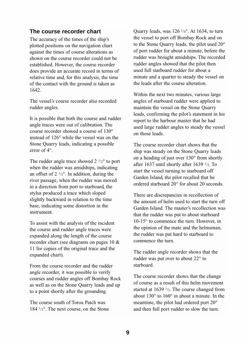
The course recorder chartThe accuracy of the times of the ship’splotted positions on the navigation chartagainst the times of course alterations asshown on the course recorder could not beestablished. However, the course recorderdoes provide an accurate record in terms ofrelative time and, for this analysis, the timeof the contact with the ground is taken as1642.
The vessel’s course recorder also recordedrudder angles.
It is possible that both the course and rudderangle traces were out of calibration. Thecourse recorder showed a course of 130°instead of 126° while the vessel was on theStone Quarry leads, indicating a possibleerror of 4°.
The rudder angle trace showed 2 1/2° to portwhen the rudder was amidships, indicatingan offset of 2 1/2°. In addition, during theriver passage, when the rudder was movedin a direction from port to starboard, thestylus produced a trace which slopedslightly backward in relation to the timebase, indicating some distortion in theinstrument.
To assist with the analysis of the incidentthe course and rudder angle traces wereexpanded along the length of the courserecorder chart (see diagrams on pages 10 &11 for copies of the original trace and theexpanded chart).
From the course recorder and the rudderangle recorder, it was possible to verifycourses and rudder angles off Bombay Rockas well as on the Stone Quarry leads and upto a point shortly after the grounding.
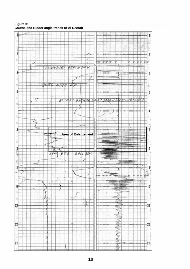
The course south of Toroa Patch was 184 1/2°. The next course, on the Stone
Quarry leads, was 126 1/4°. At 1634, to turnthe vessel to port off Bombay Rock and onto the Stone Quarry leads, the pilot used 20°of port rudder for about a minute, before therudder was brought amidships. The recordedrudder angles showed that the pilot thenused full starboard rudder for about aminute and a quarter to steady the vessel onthe leads after the course alteration.
Within the next two minutes, various largeangles of starboard rudder were applied tomaintain the vessel on the Stone Quarryleads, confirming the pilot’s statement in hisreport to the harbour master that he hadused large rudder angles to steady the vesselon those leads.
The course recorder chart shows that theship was steady on the Stone Quarry leadson a heading of just over 130° from shortlyafter 1637 until shortly after 1639 1/2. Tostart the vessel turning to starboard offGarden Island, the pilot recalled that heordered starboard 20° for about 20 seconds.
There are discrepancies in recollection ofthe amount of helm used to start the turn offGarden Island. The master’s recollection wasthat the rudder was put to about starboard10-15° to commence the turn. However, inthe opinion of the mate and the helmsman,the rudder was put hard to starboard tocommence the turn.
The rudder angle recorder shows that therudder was put over to about 22° tostarboard.
The course recorder shows that the changeof course as a result of this helm movementstarted at 1639 1/2. The course changed fromabout 130° to 160° in about a minute. In themeantime, the pilot had ordered port 20°and then full port rudder to slow the turn.
9
10
Figure 3:Course and rudder angle traces of Al Deerah
Area of Enlargement
11
Courses Rudder angles
1630
1634
1636
1638
1640
1642
On Stone Quarry leads
Contact with bottom
Port helm to arrestturn off Garden Island
Course alteration offGarden Island
Starboard helm foralteration off GardenIsland
120 160 200 240 40 30 20 10 0 55 10 20 301515 40
Port Starboard
Figure 4:Enlargement of course and rudder angle traces (in ship’s time)
3
2
The rudder angle recorder appears toindicate that it took almost a minute for therudder to move from amidships to hard overto port. However, given the distortion in thetrace together with any cumulative delays inissuing and responding to helm orders, firstto port 20°, then hard over to port, the timetaken is not considered significant.
Despite the rudder being put over to port,the course recorder shows that the ship’shead went to about 170° at 1641, fromwhich time, after the rate of turn appeared tohave slowed momentarily, the courseincreased to a maximum of 210° at 1642.Contact with the bottom off Garden Island isconsidered to have occurred at this time.
The vessel then came around to port from210° to 150° as the pilot conned the vesseloff Garden Island and round Saltpan Point.
The alteration off Garden Island A local pilot advised that the optimumwheel-over mark to start an alteration offGarden Island on a southbound passage iswhen the first and third lights on that islandare in transit. As the turn is made, the leastdistance off the island can be maintained atabout 0.05 miles or about 90 metres.
The course recorder chart shows that thealteration to starboard commenced shortlybefore 1639 1/2. The amount of rudder usedto start the turn was about 22° to starboard.Counter rudder was applied within a minuteof the start of the turn, increasing to fullport rudder for about a minute before thegrounding. Despite the counter rudder, AlDeerah sheered to starboard, grounding atabout 1642 in position 41° 06.96’S, 146°48.90’E, with Point Effingham light bearing154° (T) distance 1.34 miles.
The grounding occurred about 2 1/2 minutesafter the ship’s head started to move tostarboard following the wheel-overcommand to alter course to pass to the eastof Garden Island.
The mate had plotted two positions whilethe vessel was on the Stone Quarry leads.The distance between the two positions was0.39 of a mile (723 m), indicating a speed ofabout 7.8 knots. The average speed from thetime of embarking the pilot to the 1640position was about 10.54 knots. Whenfixing a ship’s position there are inherentinaccuracies caused by the time lapsebetween observing angles, distances orpositions and recording the time. Theseinaccuracies are amplified over shortdistances and when navigation marks areclose to the ship. How closely the mate’stime base was aligned with the courserecorder could not be established. For thesereasons, it is not possible to reconcile theship’s plotted positions with the courserecorder chart to allow any form of accuratecomparative analysis.
Effects of tidesThe Shiphandler’s Guide2, a NauticalInstitute publication, contains informationrelevant to the grounding of Al Deerah.
On the effect of tides, the publication states:
Whilst on the one hand, it is possible to offereasy explanations concerning the effect of thetide, it is on the other hand difficult, because thetidal flow in and around jetties and waterwayscan be extremely complex.
It should also be borne in mind that a mass ofwater on the move is several hundred timesdenser than air and thus by comparison iscapable of generating forces of enormousmagnitude.
12
2The Shiphandler’s Guide, Capt R W Rowe, FNI
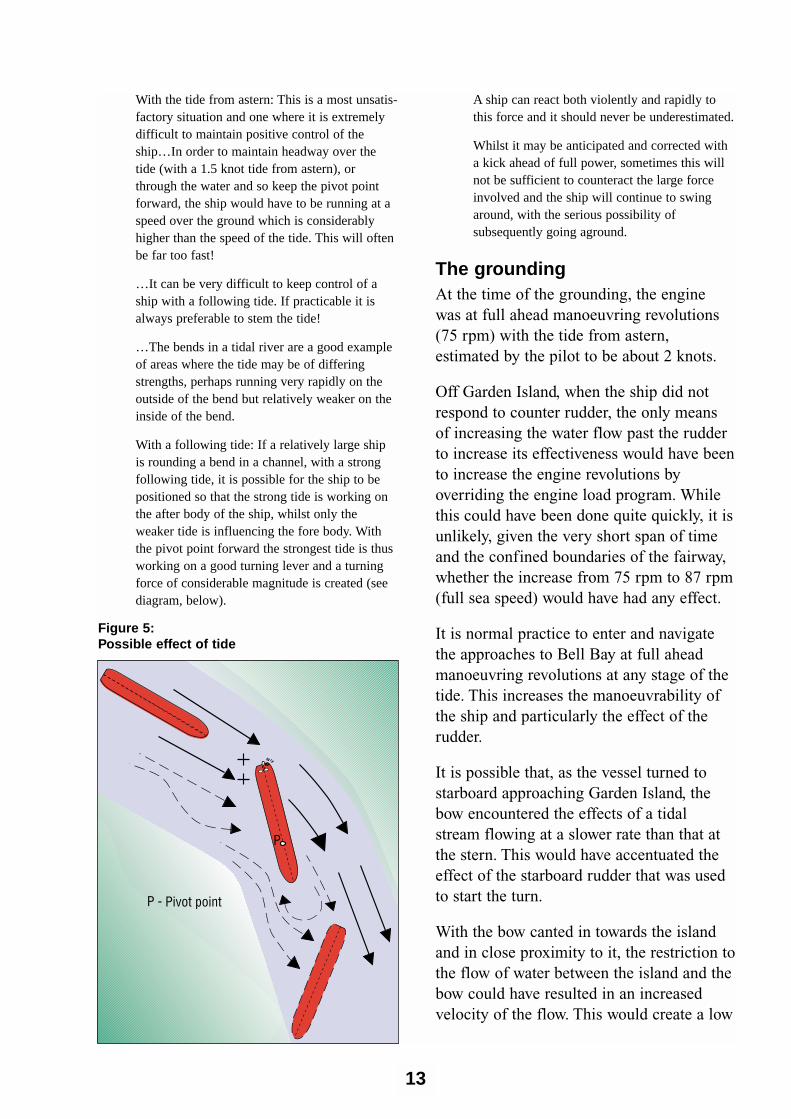
With the tide from astern: This is a most unsatis-factory situation and one where it is extremelydifficult to maintain positive control of theship…In order to maintain headway over thetide (with a 1.5 knot tide from astern), orthrough the water and so keep the pivot pointforward, the ship would have to be running at aspeed over the ground which is considerablyhigher than the speed of the tide. This will oftenbe far too fast!
…It can be very difficult to keep control of aship with a following tide. If practicable it isalways preferable to stem the tide!
…The bends in a tidal river are a good exampleof areas where the tide may be of differingstrengths, perhaps running very rapidly on theoutside of the bend but relatively weaker on theinside of the bend.
With a following tide: If a relatively large shipis rounding a bend in a channel, with a strongfollowing tide, it is possible for the ship to bepositioned so that the strong tide is working onthe after body of the ship, whilst only theweaker tide is influencing the fore body. Withthe pivot point forward the strongest tide is thusworking on a good turning lever and a turningforce of considerable magnitude is created (seediagram, below).
A ship can react both violently and rapidly tothis force and it should never be underestimated.
Whilst it may be anticipated and corrected witha kick ahead of full power, sometimes this willnot be sufficient to counteract the large forceinvolved and the ship will continue to swingaround, with the serious possibility ofsubsequently going aground.
The grounding At the time of the grounding, the enginewas at full ahead manoeuvring revolutions(75 rpm) with the tide from astern,estimated by the pilot to be about 2 knots.
Off Garden Island, when the ship did notrespond to counter rudder, the only meansof increasing the water flow past the rudderto increase its effectiveness would have beento increase the engine revolutions byoverriding the engine load program. Whilethis could have been done quite quickly, it isunlikely, given the very short span of timeand the confined boundaries of the fairway,whether the increase from 75 rpm to 87 rpm(full sea speed) would have had any effect.
It is normal practice to enter and navigatethe approaches to Bell Bay at full aheadmanoeuvring revolutions at any stage of thetide. This increases the manoeuvrability ofthe ship and particularly the effect of therudder.
It is possible that, as the vessel turned tostarboard approaching Garden Island, thebow encountered the effects of a tidalstream flowing at a slower rate than that atthe stern. This would have accentuated theeffect of the starboard rudder that was usedto start the turn.
With the bow canted in towards the islandand in close proximity to it, the restriction tothe flow of water between the island and thebow could have resulted in an increasedvelocity of the flow. This would create a low
13
P
Pivot pointP -
Figure 5:Possible effect of tide
pressure area between the bow of the shipand the bank with the result that the bowwould be drawn towards the island. In thecase of Al Deerah it is possible that thisoccurred causing additional movement ofthe bow towards Garden Island.
Despite the pilot’s use of the rudder hardover to port there was insufficient ruddereffect to arrest the turn and prevent thevessel contacting the bottom. The effect ofthe tide on the stern was probably muchgreater than the effect of the rudder, causinga large turning force to starboard acting onthe pivot point situated forward.
There were no problems with the vessel’ssteering gear.
Damage to Al DeerahAn underwater examination just after thegrounding revealed that the vessel had
sustained damage to the bottom in way ofno. 2 starboard and no. 3 starboardcombined bottom and side water ballasttanks. The bottom plating in way of thestarboard bilge at about frame 160 was setup about 500 mm.
The shell plating was holed at about frame166 with a 1.2 metre longitudinal split about150 mm in width. There was also a hole inthe shell 400 mm long, 250 mm wide atframe 143, below and around the starboardbilge keel. A crack extended from the top ofthis hole around the bilge keel pad.
The ballast tanks were protectively arrangedaround the cargo tanks, but no. 1 heavy fueloil storage tank, between the fore peak tankand no. 1 cargo oil tank was unprotected.Damage to this area of the ship could haveresulted in an outflow of heavy fuel oil intothe river.
14
ConclusionsThese conclusions identify the differentfactors contributing to the incident andshould not be read as apportioning blame orliability to any particular individual ororganisation.
Based on the evidence available, thefollowing factors are considered to havecontributed to the incident:
1. The effects of starboard rudder anddiffering tidal strengths at the bow andthe stern of the vessel resulted in thevessel sheering to starboard.
2. The sheer to starboard may have beenaccentuated by a hydrodynamic force tostarboard acting on the bow as thevessel closed on Garden Island.
3. The rate of turn from the wheel-overposition north of Garden Island wasmore rapid than had been anticipatedand could not be reduced although fullcounter rudder was applied.
4. According to the rudder angle recorder,the rudder was hard to port for about aminute, but there was no response untilcontact with the bottom off GardenIsland, when the vessel began swingingto port.
5. The vessel was at full aheadmanoeuvring speed and it is probablethat any attempt to increase thepropeller revolutions, after it becameapparent that counter rudder was notaffecting the rate of turn, would nothave prevented the grounding.
15
16
Figure 6:Al Deerah grounding off Garden Island: Events and causal factors chart
17
EventsIncidentConditions
Key:

18
SubmissionsUnder sub-regulation 16(3) of theNavigation (Marine Casualty) Regulations,if a report, or part of a report, relates to aperson’s affairs to a material extent, theInspector must, if it is reasonable to do so,give that person a copy of the report or therelevant part of the report. Sub-regulation16(4) provides that such a person mayprovide written comments or informationrelating to the report.
The final draft of the report, or relevantparts thereof, was sent to the pilot and theharbour master of the Port of Launceston,the master, the mate, owners of the vesseland the Australian solicitors for the ownersof the vessel.
Submissions were received from the harbourmaster, the pilot, the owners and theirsolicitors and the report was amended whereappropriate.
The pilot’s submission stated in part:
I was comfortable with the point at which Iinitiated the turn round Garden Island, and wassatisfied with my distance off the Island duringthe first (approx) 1⁄2 of the turn from (approx)126° True to complete the turn to steady on(approx) 190° True towards Ashmans Point,prior to turning to port to round Saltpan Point.
Given that the tidal flow is variable and at timesnot in line with the channel, only experience candictate the amount of helm required to (a)initiate, and (b) to maintain and control, the safenegotiation of the alteration.
By the time I realised that, in spite of hard-toport helm, the vessel was heading into danger,there was no time (and no point) in asking forEmergency Full Ahead revolutions. I did notconsider stopping the main engine because Iwould have lost control and groundedelsewhere. As it turned out, I required everyamount of control available to keep the vessel inthe channel until the tugs could attend to assistthe directional stability of Al Deerah.
...With the flood tide acting on the starboardquarter and the flow coming out of York Coveon to the port shoulder towards Ashmans Point,there is a couple created to keep the vesselswinging to starboard round Garden Island.Experience dictated that the swing should bekept under close control, which is what Iendeavoured to maintain.
The owner’s submission contained thecomments,
With reference to the draft investigation report
...it states that the pilot ordered 20° of starboardrudder to start the turn off Garden Island.However, the course recorder / helm indicatorshows the helm at 25 degrees (hard over). Inaddition, the master and helmsman have statedthat the pilot ordered the helm hard over. Thehelmsman did not put the helm over the extraamount, he put the helm hard over as instructed.
We believe that given the small margins of erroroff Garden Island the river transit should havebeen planned for an ebb tide.
Solicitors for the owners stated in part,
We set out the following issues and commentsraised by our client in relation to the draft reportin the hope that it will be of some furtherassistance:-
The pilot, upon boarding the vessel, handed theMaster a passage plan, presumably based uponhis experience and local knowledge of the river,and a comprehensive evaluation of the coursesto be steered and conditions that might beencountered on the passage from the pilot’sboarding ground to the berth.
The draft report refers to The ShiphandlersGuide insofar as it relates to ‘the effect of tides’.Our clients accept the relevance and accuracy ofthe points raised.
19

20
These recommendations are publishedrecognising that corrective action mayalready have been taken by parties toaddress the safety issues identified by theinvestigation.
The duties of a port authority include anobligation to facilitate the safe use of thatport.
The owners of Al Deerah have stated thatthey believed, given the small margins oferror off Garden Island, that the riverpassage should have been planned for anebb tide.
The Inspector recommends that the Port ofLaunceston Authority review the conditions,including tidal conditions, under whichvessels enter and depart the port, consultingas appropriate with the owners andmanagers of such vessels.
21
Recommendation

22
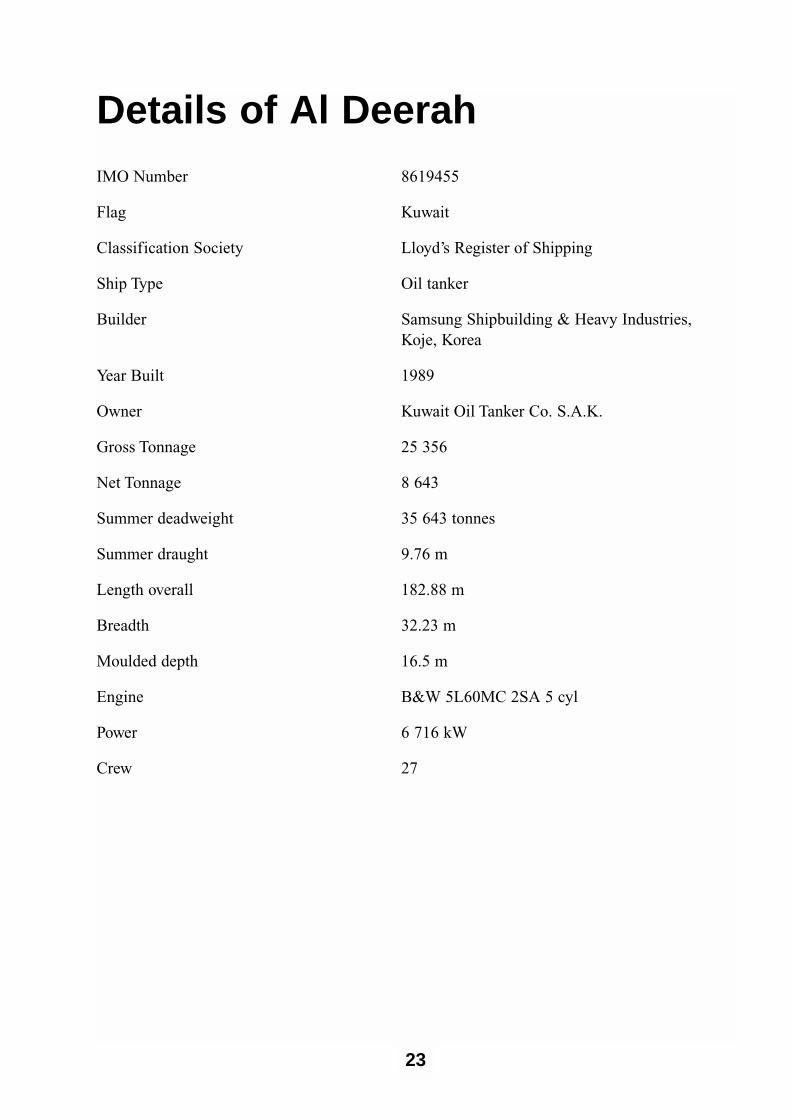
Details of Al DeerahIMO Number 8619455
Flag Kuwait
Classification Society Lloyd’s Register of Shipping
Ship Type Oil tanker
Builder Samsung Shipbuilding & Heavy Industries, Koje, Korea
Year Built 1989
Owner Kuwait Oil Tanker Co. S.A.K.
Gross Tonnage 25 356
Net Tonnage 8 643
Summer deadweight 35 643 tonnes
Summer draught 9.76 m
Length overall 182.88 m
Breadth 32.23 m
Moulded depth 16.5 m
Engine B&W 5L60MC 2SA 5 cyl
Power 6 716 kW
Crew 27
23

24