Embed Size (px)
Citation preview

REPORT ON
EVALUATION OF GOLD POTENTIAL
SCROGGIE CREEK PLACERS (4955 WK!X LTD.!
DAWSON MINING DISTRICT, YUKON
FOR
BURNT ISLAND GOLD LTD.
- . Yancouver, B. C.
ad Canada
i.
October 1384 File: 115-06

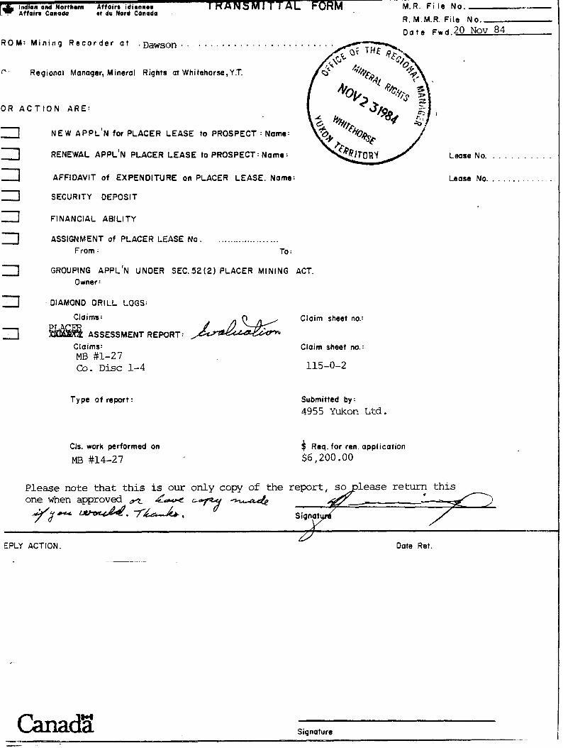
ROM: M i n i n g R e c o r d e r a t . . . . . . . . . . . . . . . . . . . . . . . .
r * Regional Manager, Mineral Rights at Whitehorse,Y.T.
OR A C T I O N ARE:
NEW APPL'N for PLACER LEASE to PROSPECT : Name:
. . . . . . . . . RENEWAL APPL'N PLACER LEASE to PROSPECT: Name : ~ w s e No.
AFFIDAVIT o f EXPENDITURE on PLACER LEASE. Name: Lease No. . . . . . . . . . . .
SECURITY DEPOSIT
FINANCIAL ABlLl TY
ASSIGNMENT of PLACER LEASE No ..................... From : To :
GROUPING APPL'N UNDER SEC. 5 2 ( 2 ) PLACER MINING ACT Owner:
DIAMOND DRILL LOGS:
Claims: Claim sheet no.:
ASSESSMENT REPORT: Claims: MB #1-27 Co. D i s c 1-4
Type o f report:
Cls. work performed on
MB #14-27
Claim sheet no.:
115-0-2
Submitted by:
49 5 5 Yukon Ltd .
$ Req. for ren. application $6,200 .OO
Please note that this is our only copy of the one when approved ar d
EPLY ACTION. Date Ret.
-
Canads Signature - -

11.0 EXECUTIVE SUMMARY :.
T." Fie ld t e s t i n g o f p l a c e r ground on Scroggie Creek, 100 km (62 m i l e s ) south of
Dawson, Yukon T e r r i t o r y , has r e s u l t e d i n t h e d e l i n e a t i o n of between 3,700,000 3 and 4,500,000 yd o f economic g rave l .
These g r a v e l s which a r e s i t u a t e d on a high bench above Scroggie Creek, a r e t h e
remains o f r i v e r s which flowed a t . r o u g h l y t h e same time a s t h e "White Channel"
g r a v e l s around Dawson.
The o v e r a l l g rade of t h e Scroggie Creek p l a c e r ground under op t ion t o Burnt 3 I s l and Gold Ltd. i s between Can98 t o $lO/yd (~ .S .$337 .00 ) a l lowing f o r 910
f i n e n e s s .
A minimum n e t p r o f i t o f $3 .00/~d ' can be achieved i f mining u t i l i z i n g c e n t r i f u g a l
recovery i s p r a c t i c e d .
4
No permafrost w i l l e x i s t i n t h e g r a v e l s f o r t h e f i r s t two mining seasons. The
reason f o r t h i s i s t h a t previous o p e r a t i o n s c l e a r e d overburden and vege t a t i on a - from an a r e a measuring 1000 m (3300 f t . ) by 600 m (2000 f t . ) .
REIMCHEN URLICH GEOLOGICAL ENGINEERING
EDMONTON VANCOUVER

T A B L E O F C O N T E N T S
INTRODUCTION
Purpose
Scope
Terms o f Reference
Responsibilities
PROPERTY .DEFINITION
Ownership
Location
Accessibility
LANDSCAPE AND CLIMATE
Landscape
Climate
HISTORY
1898 to 1 91 5
1916 to 1933
1934 to 1945
1946 to 1950
1951 to 1955 .
1956 to 1974
1975 to 1981
Summary
REGIONAL GEOLOGY
Bedrock Geology
Tertiary-Quaterna'ry Geology
FIELD TESTING PROGRAM
Organization
Sampl i ng and Mapping
Primary Processing
REIMCHEN URLICH GEOLOGICAL ENGINEERING
EDMONTON VANCOUVER
Page
1 1
1 1
1

T A B L E 0 F C 0 N T E N T S (Continued)
Page
LABORATORY TESTING PROGRAM
Preparation
Secondary Processing
Go1 d Analyses
Platinum and Chromium Analyses
Gradation
SCROGGIE CREEK SURFICIAL GEOLOGY
Terrace Description
Gravel Description
Creek Gravel s
Bench Materi a1 s
Geologic Interpretation
Lower Gravel s
Middle Gravel s
Upper Gravel s
A1 1 uvial Fan Gravel s
Scroggi e Creek Gravel s
VOLUMES/OVERBURDEN/GRADE
Vol umes
Grades
MINING CONSIDERATIONS
Historical Review
Recovery Criteria
Spinning Barrel Concentrator
Concentration Operation
Security
EXECUTIVE SUMMARY 2 7
REIMCHEN URLICH GEOLOGICAL ENGINEERING
EDMONTON VANCOUVER

T A B L E 0 F C 0 N. T E N T S (Continued)
FIGURE 1 Scroggie Creek - Area Locat ion
FIGURE 2 Scroggie Creek - A c c e s s i b i l i t y
FIGURE 3 Scroggie Creek Placers - Proper ty Map
FIGURE 4 Test Locat ions
FIGURE 5 Schematic Composite S t ra t i g raphy
FIGURE 6 Photographs o f Spinning Bar re l Test and Product ion P lan ts
Fol low ing Paqe
? -
it,
REIMCHEN URLICH GEOLOGICAL ENGINEERING
E D M O N T O N VANCOUVER

INTRODUCTION
Purpose
Reimchen Url ich Geological Engineering (RUGE) was commissioned by Burnt Island
Gold Ltd. to evaluate the gold potential of the Scroggie Creek placer claims
(4955 Yukon Ltd.) in the Dawson Mining District, Yukon Territory.
Scope
fo1 lowing scope of work was performed:
interpretation of air photographs and review of literature pertinent
to the claim area;
field exploration including geologic mapping, bul k sampl ing and
primary processing ;
1 aboratory testing ,i ncl uding secondary processing and fire assays to
determine gold content;
geological and engineering assessment of data obtained and evaluation of
gold potential; and
preparation of this report, complete with data summary, maps, sections,
conclusions and recommendations.
Terms of Reference
The completed scope of work was performed in accordance with our July 30 1984
letter and subsequent communications between officers of Burnt Island and Ted
Reimchen of RUGE.
Responsibilities
Ted Reimchen, M. Sc. , P. Geol . , geo'logi st and partner of RUGE, was responsible for project management, direction and co-ordination. He initiated the geological
mapping, the geologic interpretations, field sampling and material processing,
performed and evaluated the gold potential and mining feasibility of the claims.
REIMCHEN URLICH GEOLOGICAL ENGINEERING
EDMONTON VANCOUVER

Ebo Bakker, M.Sc., g e o l o g i s t of R U G E , was i n charge of t h e f i e l d program.
He performed t h e geologic mapping, d i r e c t e d t h e f i e l d sampling and ma te r i a l
p rocess ing , a s s i s t e d wi th t h e geologic i n t e r p r e t a t i o n and gold p o t e n t i a l
eva lua t ion , and a s s i s t e d wi th t h e p repa ra t i on of t h i s r e p o r t .
Cecil Ur l i ch , M.Sc., P.Eng., geo technica l eng inee r and p a r t n e r o f R U G E , was
in charge o f t h e l abo ra to ry program. He d i r e c t e d t h e sample p repa ra t i on and
screening , performed t h e t a b l i n g , c a l c u l a t e d t h e gold va lues , a s s i s t e d in
eva lua t ing mining and processing a l t e r n a t i v e s , a n d - o u t l i n e d t h i s r e p o r t . I i
S p e c i f i c r e s p o n s i b i l i t i e s were de lega ted wi th in RUGE t o Meheram Sugrim (pr imary
process ing , secondary sc reening and g rada t ion a n a l y s e s ) , Pa t Whiting ( r e p o r t
p r e p a r a t i o n ) , Ian Thomson and Jack Sc r ivene r ( d r a f t i n g ) and Bobbie Grimard
( t yp ing ) -
F i r e assays and gold weighing were completed by Larry Wong, c e r t i f i e d a s saye r
of General Tes t i ng Labora to r i e s o f Vancouver. Ron Campbell and Larry Bratvold
o f Barker Creek P lace r Explora t ion Corp. o f Whitehorse suppl ied equipment and
add i t i ona l manpower f o r t h e f i e l d program, and organized i t s mobi l iza t ion and de-
mobi l iza t ion .
REIMCHEN URLICH GEOLOGICAL ENGINEERING
EDMONTON VANCOUVER

2.0 PROPERTY DEFINITION
Ownership
4955 Yukon Ltd. of Whitehorse, r e p o r t e d l y owns t h e fo l lowing 31 claims on Scroggie
Creek i n t h e Yukon T e r r i r o t y :
Type Number Claim Number
p l ace r c l aim 27 P24849 - P24875
co-di scovery c la im 4 P24879 - P24882
All o f t h e s e c la ims have been grouped t o g e t h e r and a r e r e f e r r e d t o i n t h i s
r e p o r t a s t h e Scroggie Creek c la ims , t h e s u b j e c t c l a ims , o r t h e s u b j e c t a r e a .
2.2 Location
Scroggie Creek i s l o c a t e d i n t he southwest p a r t of t h e Yukon T e r r i t o r y , approxi-
mately 100 km (62 mi l e s ) south of Dawson and 140 km (85 m i l e s ) west of P e l l y
Crossing. The c reek i s a t r i b u t a r y t o S tewar t River , 35 km (22 mi l e s ) upstream
of t h e S tewar t and Yukon River confluence (F igu re s 1 and 2 ) .
The 27 c la ims a r e l oca t ed on the bench on the south s i d e o f Scroggie Creek and
extend f o r approximately 5 km (3.1 mi 1 e s ) . The e a s t e r n most c la im boundary i s
approximately .25 km ( . I 6 mi l e s ) upstream of t h e j unc t ion wi th Walhalla Creek
(F igu re s 2 and 3 ) .
The 4 co-discovery claims a r e ad j acen t t o t h e bench claims and cover t h e lower
end o f two t r i b u t a r i e s t o Scroggie Creek (F igu re 3 ) .
REIMCHEN URLICH GEOLOGICAL ENGINEERING
EDMONTON VANCQUVER


Accessi bi 1 i ty
Road access t o Scroggie Creek from the Whitehorse-Dawson highway i s only possible
in winter. This access follows the historical Dawson-Whitehorse wagon road
which runs west from Pelly Crossing and along Walhalla and Scroggie Creeks. The
closest point t o the subject claims that can be reached by all-weather roads i s
on Black Hil ls Creek which i s located 100 km (62 miles) from Dawson and 35 km
(22 miles) from the Scroggie Creek claims across the Stewart River (Figure 2 ) .
An a i r s t r i p i s l ~ c a t e d just southeast of the subject claims a t the junction of
Scroggie and Walhalla Creeks.
In the early 1900's, sumner transport was provided by steamers on the Yukon and
Stewart Rivers. Transport by barge on these r ivers i s s t i l l a possibi l i ty .
LANDSCAPE AND CLIMATE
Landscape
The Scroggie Creek area i s si tuated in an unglaciated part of the Cordilleran
Physiographic Region and i s characterized by a plateau area composed of long
ridges spreading from a central divide. These ridges a re separated by closely
spaced small creeks which merge into larger streams in gradually widening
valleys. The drainage pattern i s radial on a regional scale and dendrit ic on a
local scale. Stream gradients are even and uninterrupted by rapids or lakes.
Valleys are V-shaped with sides f lar ing upwards and diminishing in steepness
until the broad, rounded ridges of the upland are reached. Intermittent bedrock
terraces carved by former streams along many of the larger valleys are mantled
by variable thicknesses of gravel, sand and s o i l . These ancient stream levels
have more gentle gradients than the present streams.
Elevations in the Scroggie Creek area range from 366 m (1200 f t . ) above sea level
a t Stewart River to 1387 m (4551 f t . ) a t Pyroxene Mountain. The claims are
located a t elevation 460 to 488 m (1 500 to 1600 f t . ) above
Forest growth i s generally sparse. Trees grow on the f l a t
REIMCHEN URLICH GEOLOGICAL ENGINEERING
EDMONTON VANCOUVER
sea level (Figures 2 and 3 ) .
valley floors as well as

in the draws and on the h i l l s ides to approximately 1065 m (3500 f t . ) above sea
level. Black spruce and birch are the most common of the fores t t rees . They
grow a t a l l elevations up to the timber l ines. Poplar and white spruce are l e s s
common. Level areas a re mainly covered with muskeg.
3.2 Climate
A t l e a s t f ive months of the year a re favourable f o r surface work. Rivers generally
open up in ear ly May and freeze-up s t a r t s any time a f t e r mid-October. Occasionally
r ivers remain open until early November. aecause of almost continuous daylight
during June and July, work in the summer can be conducted around the clock. Winters
are cold b u t not extreme. Precipitation i s normally not heavy and approaches semi-
arid conditions during some seasons. Nearly a l l of the sur f ic ia l materials are
perpetually frozen (permafrost) from close to ground surface down to bedrock. In
sumner me1 t ing generally does not extend deeper than 100 cm ( 3 f t . ) below the ground surf ace.
4.0 HISTORY
Following the discovery of gold in the Dawson area in 1896 and the subsequent gold
rush, a number of t r ibutar ies near the confluence of Stewart and Yukon Rivers
was stampeded and staked during the l a t t e r part of 1898. Scroggie Creek was
"discovered" by J. G. Stephens and H. l e Duke on August 27, 1898. This discovery
took place 10.8 km (6.7 miles) upstream of the Scroggie-Walhalla Creek junction.
On the same date, two claims above biscovery were staked by the Scroggie brothers.
The Scroggie concession, extending 4 km (2% miles) above to 4 km below Discovery,
was held by E. B . Scroggie from October 1900 to April 1906. The to ta l gold
recovered from t h i s property probably did not exceed 118 to 176 oz. After
April 1906, some of the claims were staked on the same ground by others, b u t
minimal prospecting and mining was carried o u t .
REIMCHEN URLICH GEOLOGICAL ENGINEERING
E D M O N T O N VANCOUVER

In 1911, s i g n i f i c a n t amounts of gold were r e p o r t e d l y discovered 2.4 km ( 1 . 5
mi l e s ) above Discovery. In t h e f i r s t y e a r i t was repor ted t h a t 353 oz. of
gold were recovered. In September 191 5 , 1 ,176 oz. o f gold were recovered.
Base l i n e s on Scroggie and Walhalla Creeks were surveyed in 1912.
In the.summer o f 1915 about 20 men mined Claim 9C above Discovery upstream on
Scroggie Creek and i t s t r i b u t a r y Mariposa Creek (F igu re 2 ) . During the w i n t e r
months, 40 t o 50 men u s u a l l y worked t h e a r e a , which included ground downstream
of Claim 9C t o t h e Wal ha1 l a Creek junc t ion . A few prospec t holes were r e p o r t e d l y
l oca t ed in t h e v a l l e y , 4.8 t o 6 .4 km ( 3 t o 4 m i l e s ) downstream o f t h e j u n c t i o n .
Bedrock was found t o e x i s t 6 m (20 f t . ) below t h e ground sur face .
Mining i n t h e e a r l y p a r t o f t h i s cen tury seems t o have been confined t o t h e
v a l l e y bottom al though gold on benches o f Eldorado Creek had been d iscovered
in 1897. Mining was done by d r i f t i n g , t h e f rozen g r a v e l s were thawed by
wood f ires and l a t e r by steam thawing.
The t o t a l amount of gold produced dur ing 1898 t o 1915 from Scroggie Creek and i t s
t r i b u t a r i e s i s es t imated t o be 2,940 t o 4,410 o z . , but might be a s high a s 5,880 0 2 .
Gold assays performed on p l ace r gold from Scroggie Creek during this per iod y i e l d e d
f i nenes s va lues ranging from 891 t o 930.
From 1916 t o 1933, i t appears t h a t mining a c t i v i t i e s i n t h e a r ea were i n d e c l i n e .
Scroggie Creek i s no t mentioned i n the GSC r e p o r t during t h i s pe r iod , except i n a
1918 r e f e r ence t o a r epo r t ed occur rence of platinum on Scroggie Creek. Ava i l ab l e
records i n d i c a t e t h s t - t h e l a s t c la ims i n good s tanding were held t o 1919. A Mr.
Greer i s r epo r t ed t o have worked t h e Walhalla and Scroggie confluence a r e a sometime
during t h e 1920 ' s and 1930 ' s . The remains of h i s cab in can s t i l l be seen on the
e a s t s i d e of t h e j unc t ion .
Albert Le Boeuf cons t ruc t ed s eve ra l bu i ld ings on t h e west bench o f Scroggie 2 km
below t h e j unc t ion o f Walhalla and Scroggie Creek on land now owned by 4955 Yukon
Ltd. In f a c t , our exp lo ra t i on p a r t y s tayed i n t h e s e o ld cab ins which a r e s t i l l
REIMCHEN URLICH GEOLOGICAL ENGINEERING
EDMONTON VANCOUVER

in good r e p a i r . Le Boeuf ground s l u i c e d and s h a f t e d an a r e a 200 m x 300 m x 4 n-~
t h i cknes s du r ing h i s t e n u r e i n t h i s a r ea . The o u t e r l i m i t s o f t h e t e r r ace /bench
have been ground s l u i c e d t o about 4 m. Water was brought t o the a rea by a hand
dug d i t c h abou t 1000 m i n length . Two small steam b o i l e r s wi th steam p o i n t s
a r e s t i l l l o c a t e d on t h e edge o f t h e bench. These ope ra t i ons began be fo re World
War I and were cont inued by Le Boeuf u n t i l the l a t e t h i r t i e s . He d i ed i n White-
horse i n 1941.
From 1932 t o 1935, gold g radua l ly increased i n va lue from USB20.67 t o $35.00/oz.
This r e s u l t e d i n an i n t e n s i f i c a t i o n of ope ra t i ons .
Each yea r from 1934 t o 1940, only a few mines were a c t i v e on Scroggie Creek, but
no p l a c e r l e a s e s were i n good s tanding . The most d e t a i l e d information from t h i s
period i s t h a t i n 1935 "a miner working on a bench o f Scroggie Creek below t h e
mouth of Walhalla Creek has been recover ing a cons ide rab l e percentage of plat inum
with his gold". This was Alber t Le Boeuf, descr ibed prev ious ly .
From 1941 t o 1945 t h e r e were p l a c e r l e a s e s (probably above Discovery) i n good
s tanding on Scroggie Creek. These were probably held by Numalaka Mining Company
Limited which r e p o r t e d l y prospected from 1944 t o 1945, and d r i l l e d i n 1945.
The company d i d no t prove s u f f i c i e n t va lues t o warrant f u r t h e r development.
By t h e end
of most of
a f i x e d go
throughout
t h e mines i n t h e a r e a . The con t inua t ion of t h i s t r e n d ,
I d p r i c e , r e s u l t e d in l a r g e s c a l e c l o s i n g down of gold m
Canada dur ing t h e l a t e 1940 ' s .
o f 1945, i nc reas ing labour and supply c o s t s caused t h e c l o s i n g down coup1 ed w i t h
i n ing ope ra t i ons
In 1948, t h e Federal government introduced t h e Emergency Go1 d Mining Ass i s t ance
Act. Gold proquct ion .. was subs id ized by lowering t h e r o y a l t y t o 22+%. Mining
then recomnenced a t most p l a c e r mines i n t h e Yukon T e r r i t o r y .
REIMCHEN URLICH GEOLOGICAL ENGINEERING
EDMONTON VANCOUVER

From 1955 t o 1958, t h e Scroggie Creek a rea rece ived a Federal subs idy on 1758.5
oz. o f go ld , which probably refers t o t h e a c t i v i t i e s o f George Fant and Ivo r
Norbeck dur ing 1951 t o 1955.
Fant and Norbeck acqui red 8 km ( 5 mi l e s ) o f p l a c e r ground on Scroggie Creek and 3 3
prospected i t i n 1951 and 1952. They s t r i p p e d 12,200 m (16,000 yd ) i n t h r e e
c u t s about 180 m (600 f t . ) a p a r t and dug two bedrock draws, each 150 m long by
4 m wide by 3 m deep (500 by 14 by 10 f t . ) f o r s l u i c i n g . From 1953 t o 1955 t h e y
mined with a bu l ldozer and s l u i c e box and recovered 666.07 oz. o f go1 d.
In 1955 i t was decided t h a t the ground was no t p r o f i t a b l e and t h e o p e r a t i o n was
abandoned. Hi1 ke r (1981 ) r e f e r r i n g t o a 1980 r e p o r t by G. R. Hilchey l o c a t e s
t h e s e c la ims above Discovery near Mariposa Creek.
P l ace r mining i n t h e Yukon T e r r i t o r y was low-keyed from 1956 t o 1974. In t h e
mid-1960's most p l ace r ope ra t i ons had ceased and by 1966 t h e l a s t dredge had
shu t down.
Rising gold p r i c e s in t h e e a r l y 1970 ' s c r ea t ed new i n t e r e s t . By 1974, most o f
the h i s t o r i c producing s t reams, and many s t reams flowing through unfavourabl e geologica l s e t t i n g s had been s taked .
Scroggie Creek i s n o t mentioned in the o f f i c i a l mining r eco rds between 1955 and
1980. However, H i lke r (1981) quot ing from the Hilchey r e p o r t mentions a c t i v i t i e s
during 1975 and 1976 by Yugold Mines Ltd. Tes t i hg was done from Claims No. 2
below t o No. 10 above Discovery, and on Mariposa Creek, using a D8 bul l d o z e r ,
rubber t i r e d l o a d e r , a small s l u i c e box and two pumps. Reportedly 11.45 and
63.35 oz. o f gold were recovered i n 1975 and 1976 r e s p e c t i v e l y . We have been 3 3 informed t h a t this gold was recovered f r o m 7 6 5 m ( 1 0 0 0 y d ) of raw f eed , which
3 would r e s u l t i n a gold grade o f 0.0748 oz/yd . Based on a gold p r i c e o f Can. 3 $450/oz. t h i s computes t 6 $33.66/yd .
REIMCHEN URLICH GEOLOGICAL ENGINEERING
EDMONTON VANCOUVER

During 1980 and 1981, Herman Axel worked t h e a r ea where much o f September 1984
t e s t i n g was done ( F i g u r e 4 i n s e r t ) . Black overburden s o i l was s t r i p p e d by two
08 bu l ldoze r s from a l a r g e a r e a on t h e same bench and j u s t upstream from a
prev ious ly worked a r ea . Some t e s t mining was done on t h i s bench and i n t h e
v a l l e y , dur ing which both D8s were n e a r l y l o s t in t h e thawed overburden.
Herman Axel p r e s t r i p p e d a 1 a r g e a r e a o f overburden and muck (300 m x 600 m) i n
t h e a r e a a d j a c e n t t o A1 b e r t Le Boeuf 's cab in (F igure 3 ) . His method of mining
involv ing a 200 ya rd lhour s l u i c e box r e s u l t e d in a r epo r t ed recovery of $6 t o
$8/yd3. No r ecogn izab le organized mining procedure was followed. Materi a1 was
pushed over 150 m u p h i l l by a D8 bul ldozer towards t h e s l u i c e box perched on a
h i l l top. S ince t h e g r a n i t i c bedrock i n t h i s a r ea i s j o i n t e d in s eve ra l d i r e c t i o n s ,
t h e ma te r i a l r e a d i l y breaks in small sub-angular blocks resembling r u s t y s c h i s -
t o s e g rave l . Th i s ma te r i a l i s ba r r en , y e t l a r g e volumes were processed a c r o s s 3
t h e s l u i c e t a b l e s . Recovery on t h i s p roper ty averaged $6 t o $8/yd based on
a Can.$450/oz. gold p r i ce . Platinum was a l s o recovered bu t q u a n t i t i e s were no t
recorded pub l i c ly .
Reportedly, 100 t o 200 oz. of gold were recovered i n 1980, and 1400 t o 1500 oz.
dur ing two months of 1981 f o r a t o t a l o f 1600 oz. Records from Del ta Smelt ing
and Refining Co. Ltd. revea l t h a t 1624 oz. o f gold were recovered from Scroggie
Creek dur ing t h i s time.
REiMCHEN URLICH GEOLOGICAL ENGINEERING
EDMONTON VANCOUVER

4.8 Sumnary
Drainage areas of a l l creeks near the Stewart-Yukon River confluence are underlain
by rocks of the same geological units as Scroggie Creek. All creeks have probably
been prospected in the past. Mining operations have been and are s t i l l carried
out in several of the creeks, the most famous of which are Scroggie, Barker,
Thistle, Kirkman and Brewer. In yearly reports, these creeks are always
favourably mentioned as having placer gold potential .
I t i s c lear tha t most t r ibutar ies of the Stewart and Yukon Rivers near the i r
confluence have supported small operations in the 1900's. Some work has probably
also been done on nearby creeks which are not mentioned in th i s report. The f u l l
potential of most of the creeks in th i s area probably has never been eyplored be-
cause of the large and more easi ly accessible gold reserves that were discovered
and worked in the Klondike area near Dawson.
From the available reports i t seems that a l l major mining in the past was confined
to Scroggie Creek upstream of the Walhalla Creek junction. All major mining before 1950 appears t o have been done in the valley bottoms. No information i s available about Walhalla Creek, although prospecting to some extent must have been done.
Some information exis t s downstream of the Scroggie-Walhalla junction. A few
prospect holes were completed in the valley downstream of the subject claims,
b u t no de ta i l s are available. Platinum was reportedly recovered with gold on a
bench below the mouth of Walhalla Creek in 1935, b u t no location or de ta i l s a re
available. Mining was completed by Herman Axel in 1980 and 1981 in the subject
claims. Reportedly 1,624 oz. were recovered of which 1,100 to 1,400 oz. were re-
covered in two months.
Aerial photographs taken in the 1960's show c lear evidence of major a c t i v i t i e s
in the area of the subject claims (Figure 4 ) . No reference to these a c t i v i t i e s
could be found except maybe the 1935 platinum report.
REIMCHEN URLICH GEOLOGICAL ENGINEERING
EDMONTON VANCOUVER

- 11 - 5.0 REGIONAL GEOLOGY
5.1 Bedrock. ~ e o l ogy .-
The Scroggie Creek area forms part of the Yukon Cataclastic Complex, a tectono-
metamorphic u n i t characterized by high pressure and re1 a t ive low temperature .metamorphism. Rocks i n t h i s Complex consist mainly of Paleozoic metasediments
and metavolcanics of the Big Salmon Metamorphic Complex and Nasina Series (gneisses and schis ts w i t h some quartzite, 1 imestone, s l a t e and greenstone) with widespread Paleozoic granodiorite (Pelly Gneiss) and some small ultrabasic intrusions. These
rocks were metamorphosed during the Triassic and Jurassic Tahl tanian and Ink1 inian orogenies (21 0 to 190 my). Post-orogenic grani t ic intrusions of Cretaceous age
(Coast Intrusion) are f a i r ly widespread and often cover large areas. In a few
loca l i t ies intrusions of Tertiary age occur.
The following rocks a l l occur i n the drainage area of Scroggie Creek: Mica sch i s t s
and gneisses, quartzite sh i s t s and gneissoid quartzi te , kyanite schis ts and garneti- ferous grani t ic and pegmati t i c rocks. Occasional dykes and other small in t rus
masses of semi-basic to basic rocks a l so occur. The subject claims are under
by Cretaceous coarse white granite, and gneisses,schists and limestone of t h e
Nasina Series. Exposures are scarce and occur mainly i n the steeper parts of
i ve l a in
the valley walls along the creeks. O f par t icular interest is Pyroxene Mountain w i t h
a body of massive coarse green pyroxenite. Similar ultramafic bodies are comnonly
the source of placer platinum and chromite.
The source of the placer gold i n the area i s not conclusively known, b u t possible sources are: The Nasina gneisses and schis ts which underlie much of the drainage basin of Scroggie and Wal ha1 la Creeks, ~lond' i ke schists to the north and upstream
on Walhalla Creek, or quartz veins associated w i t h Cretaceous grani t ic intrusions.
5.2 Tertiary-Quaternary Geol oqy
The Yukon Plateau represents a region which was extensively planated (pre- Paleocene to post-Eocene) during a long period of crustal s t ab i l i t y . This period
was followed by a widespread up1 i f t ( l a t e Miocene, Pl iocene o r early Pleistocene) and rejuvenation of streams, which rapidly incised their channels in the new up-
land. Between Stewart and Yukon Rivers the only traces.of the fonner upland are indicated by occasional straight-topped ridges. Bedrock' i s mostly obscured by
the products of rock weathering and other sur f ic ia l accumulations.
REIMCHEN URLICH GEOLOGICAL ENGINEERING
EDMONTON VANCOUVER

A marked feature in connection with the valleys are the terraces, w i t h one main
terrace characterizing each creek. The terraces are overlain by stream gravels
and represent former, higher positions of the streams. Because of a local up t i l t
of the land surface or a sudden change in drainage pattern of the main r ivers, the streams recently started incising again. This resulted i n quite abrupt rock
walls rising to the elevations of the former stream positions, or what constitute the present terraces and the deeper, more constricted channels.
No large scale, continental glaciation took place in th is part of the Yukon Plateau during the Pleistocene Epoch. However, in the larger valleys, small local
valley glaciers have been present for short times. During the Pleistocene, the
area was located in the periglacial climatic be1 t.
Because the valley shapes were not affected by ice, they reflect dominantly fluvial val 1 ey development. These shapes range from the V-shaped youthful small
creeks ( tr ibutaries of Scroggie Creek) to the narrow flat-bottomed mature creeks (Scroggie and
6.0 FIELD TESTING
Hal halla Creeks) and wider l a te mature rivers (Stewart).
PROGRAM
6.1 Organization
The Scroggie Creek f ie ld testing program was conducted from September12
to October 15, 1984.The geology crew mobilized and demobilized on September 1 t o 30, respectively. All work t o October 6 was completed under the
direction of RUGE project manager and geologist Ted Reimchen. Subsequent
work was directed by RUGE geologist Ebo Bakker. Mr. Gene Hackney, director of Burnt Island, remained on s i t e t o Septemberl4.
A 12-inch spinning barrel concentrating plant built by Scott Masterfl ex (Fabri ca-e
tors) Ltd . of Maple Ridge, B. C. , was trucked to Dawson during la te August and
helicoptered into Scroggie Creek in two parts. A caterpil lar D6B bulldozer
supplied by Barker Creek Placer Exploration Corp. of Whitehorse, and operated by
Mr. Jim Fedell, was driven t o the claim area in early September. I t got stuck
REIMCHEN URLICH GEOLOGICAL ENGINEERING
EDMONTON VANCOUVER

seve ra l times on i t s way i n because o f t h e thawed and s a t u r a t e d n a t u r e o f t h e
ground i t t r ave r sed .
Messrs. Larry Bratvold and Ron Campbell o f Barker Creek organized food and o n - s i t e
lodging f o r t h e f i e l d crew, and took c a r e o f t h e l o g i s t i c s o f moving i n equipment. CtO\ They remained o n - s i t e t o -5, dur ing which time they a s s i s t e d w i t h t h e
f i e 1 d work. < 6.2 Sampling and Mapping
Numerpus t r enches e x i s t on t h e s u b j e c t c la ims. During t h e f i r s t few days o f t h e
program whi le t h e bu l ldoze r was coming i n , Ted Reimchen reconnoi te red t h e a r e a ,
s t a r t e d g e o l o g i c a l l y mapping i t , planned new t r ench openings, and s e l e c t e d
sample l o c a t i o n s from e x i s t i n g t r e n c h exposures , new t r ench s i tes , and t a i l i n g s
l e f t from t h e Axel opera t ion . Ebo Bakker subsequent ly superv ised c o l l e c t i o n of
t h e samples, prepared d e t a i l e d l o g s o f t h e sample l o c a t i o n s , and cont inued wi th
geologic mapping of t h e property. Most o f t h i s mapping was done du r ing two days
when t h e bu l ldoze r was being r epa i r ed .
Three geologic u n i t s , l abe l l ed "upper" , "middle" and "lower" gravel s , were i d e n t i f i e d
(F igu re 5 ) . They a r e descr ibed i n Chapter 8.0. Sample l o c a t i o n s were r e f e r r e d t o t h e s e geologic units (Table 1 ) .
Mater ia l f o r processing was excavated by the bu l ldoze r from s e l e c t e d l o c a t i o n s ,
shove l led i n t o 45-gallon drums a t t ached t o t h e bu l ldozer and t r a n s p o r t e d t o t h e
sp inning ba r r e l p l an t . For volume c a l c u l a t i o n s t h e fo l lowing convers ions were
used : 3 3 1 yd i n s i t u mater ia l = 1 . 3 yd loose mater ia l 3 1 yd loose mater ia l = 4.65 45-gallon drums
1 45-gallon drum = 75 shovels
Eighteen samples, l abe l l e d SC-1 t o 17 ( i n c l u d i n g SC-3A and 3B) were c o l l e c t e d
and processed (F igure 4 and Table 1 ) . SC-1 t o 13 were ob ta ined from t r e n c h e s on
a bench on t h e south s i d e o f Scroggie Creek. They ranged from 0.49 t o 0.82 yd 3
3 i n s i t u . SC-14 comprised 0.53 yd from Axel ' s t a i l i n g s p i l e . SC-15 t o 17 com-
p r i s e d 7 t o 25 Ib . o f ma te r i a l ob ta ined from Axel ' s s p i r a l t a i l i n g s , s l u i c e
t a i l i n a s and mater ia l found i n a tub. #
REIMCHEN URLICH GEOLOGICAL ENGINEERING
EDMONTON VANCOUVER

LOOSE * EQUIVALENT ,, MATERIAL INSITU
PROCESSED(YD~) VOLUME ( Y D3) TEST GEOLOGIC
NUMBER UNIT
SC- 1 SC- 2 SC- 3A SC- 3B SC- 4
lower grave l lower grave l 1 ower grave l middle grave l upper grave l
upper grave l upper grave l upper grave l middle grave l upper grave l
SC- 5 SC- 6 SC- 7 SC- 8 SC- 9
middl e grave l middle grave l middl e grave l 1 ower grave l Axel t a i l i n g s p i l e
25 Ib . 7 Ib .
24 Ib .
Axel s p i r a l t a i 1 i ngs Axel s l u i c e t a i l i n g s Axel t u b ma te r i a l
* Loose processed ma te r i a l volumes were c a l c u l a t e d on t h e b a s i s o f :
1 yd3 = 4.65 45-gallon drums
1 45-gal lon druqs = 75 shove l s
I
** Equiva len t i n s i t u mater ia l ! volumes were c a l c u l a t e d on t h e b a s i s o f a 1 .3 swell f a c t o r .
I
TABLE 1 FIELD TESTING PROGRAM DETAILS
RElMCHEN URLICH GEOLOGICAL ENGINEERING
EDMONTON VANCOUVER

SC-1 t o 14 were processed through the sp inning b a r r e l . SC-15 t o 17 were s e n t t o
Vancouver f o r concen t r a t i on . Representa t ive sub-samples of SC-1 t o 1 3 were
re turned t o Vancouver f o r g r ada t ion t e s t i n g .
6.3 Primary Process ing
The 12-inch sp inning b a r r e l tes t p l a n t was set up by a t r i b u t a r y t o Scroggie Creek. I t was powered by a Honda EG 3000 gene ra to r and supp l i ed w i t h creek
water by a Honda 1 .5 HP pump. Each sample was shovel led on to a 318-inch screen
and washed. Overs ize ma te r i a l was v i s u a l l y inspec ted f o r gold and d i sca rded , and unde r s i ze ma te r i a l was processed through the sp inning b a r r e l ( F i g u r e 6 ) .
The r e s u l t a n t primary concen t r a t e was washed through a 114-inch sc reen t o reduce
i t s volume. The o v e r s i z e was v i s u a l l y inspec ted f o r gold and d iscarded . Under-
size ma te r i a l was s t o r e d i n bags and t rucked t o Vancouver f o r secondary process ing .
Meheram Sugrim o f RUGE opera ted the test p l a n t under the d i r e c t i o n o f Ted Reimchen and Ebo Bakker. During process ing he washed mater ia l through the s c r e e n s and c o l l e c t e d the primary concen t r a t e . He was a s s i s t e d by Zdenek Bidrman o f Barker Creek, who shove l l ed ma te r i a l on to the screen deck, and by Jim Fedel l the bu l l - dozer ope ra to r .
7.0 LABORATORY TESTING PROGRAM ..
7.1 Prepara t ion
The primary concen t r a t e s a r r i v e d a t ou r North Vancouver l a b o r a t o r y September 28.
They were washed through the No. 10 s i e v e s i z e on September 29 and 30 i n prep- . a r a t i on f o r [li&m...tabl e secondary concen t r a t i on . Oversize mater i a1 was
inspec ted f o r gold and r e t a ined .
7.2 Secondary Process ing
Primary concen t r a t e s from SC-1 t o 17 were processed ove r a Diester t a b l e by RUGE
geotechnical eng inee r Cecil Url ich on October 1 and 2 . Four t a b l e products were
REIMCHEN URLICH GEOLOGICAL ENGINEERING
EDMONTON VANCOUVER

Test p l a n t used f o r Scroggie f i e l d program.
- k. .. - -
Product ion p l a n t used i n A t l i n p lacer operat ion.
I I BURNT ISLAND GOLD LT.D.
I PHOTOGRAPHS OF SPINNING BARREL I TEST AND PRODUCTION PLANTS

obta ined; f r e e go ld , secondary concen t r a t e , middl ings, and t a i l i n g s . Dried
secondary concen t r a t e s from SC-1 t o 14 ranged from 610 t o 2434 g which r e p r e s e n t
ove ra l l concent ra t ion r a t i o s ranging from about 500 t o 2000.
Free gold p a r t i c l e s were handpicked o u t wi th tweezers , placed i n v i a l s , and sub-
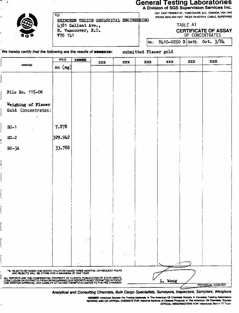
mi t ted t o General Tes t i ng f o r weighing (Appendix, Tabl es A1 and A2). Secondary
concen t r a t e s were d r i e d and s p l i t roughly i n ha l f . One-half was submit ted t o
c e r t i f i e d a s s a y e r Larry Wong o f General Tes t i ng f o r f i re a s say f o r gold con ten t .
In a d d i t i o n , a s s a y s f o r plat inum and chromite were reques ted f o r SC-2, 11 and 12.
Middling products f o r each sample were s t o r e d i n s e p a r a t e buckets. T a i l i n g s
SC-1 t o 9 and 10 t o 17 were grouped i n t o two bucke ts , r e s p e c t i v e l y .
7.3 Gold Analyses
For each concen t r a t e submi t ted , General Tes t i ng conducted f i r e a s says i n t r i p l i c a t e
(Appendix, Tab1.e~ A3 and A4). The a s s a y r e s u l t s were averaged and combined wi th
t h e weights o f free gold t o compute t h e gold va lue o f each sample (Tabl e 2 ) . A
presen t gold p r i c e o f Can$450/oz. and a f i n e n e s s of 0.91 were used i n t h e ca l cu -
1 a t i ons.
I t i s i n t e r e s t i n g t o no t e t h e l a r g e v a r i a t i o n o f up t o severa l o r d e r s of magnitude
of t h e t r i p l i c a t e a s say r e s u l t s wi th in s eve ra l o f t h e samples. I t i s a l s o e v i d e n t
t h a t t h e amount o f gold handpicked o u t o f the t a b l e d concen t r a t e was g e n e r a l l y much
l a r g e r than t h e t o t a l c o n t e n t i n t h e balance of t h e concen t r a t e a s determined by
f i r e assay .
Gold values i n the raw ground can be summarized a s fol lows:
Geologic Unit Number o f Tes t s T e s t Locat ions Range o f Values ($/yd3)
upper gravel 5 SC-4,5,6,7,9 0.01 t o 0.11
m i ddl e grave 1 5 SC-3B,8,10,11,12 0.04 t o 4.20
lower gravel 4 SC-1 , 2 , 3 ~ , 1 3 1.44 t o 15.08
Axel t a i 1 i ngs 4 SC-14,15,16,17 0.17 t o 484.48
7.4 Platinum and Chromium Analyses
General Tes t i ng conducted s i n g l e f i r e a s says on sub-samples of SC-2, 11 and 12
#
REJMCHEN URLICH GEOLOGICAL ENGINEERING
EDMONTON VANCOUVER

mu
---
bU
3a
Ob
b
CO
Ub
-C
OL
D-
00
00
-
0--N
a
*O
dd
.
..
.
..
..
....
04
s
dd
dd
d
do
ou
o
mm
-a
o
*m
N
U
- C
O
Y
u
NN
-
-o
om
F
UU
N~
O
CO
~~
e
-m
m
oo
oo
o
OO
OO
-
ma
mm
o
me
m
oo
oo
o
00
0-0
~
mo
-
om
-o
0
00
00
0
00
00
0
00
0
0-0
0
..
..
.
..
.
..
..
.
..
..
U
0
00
00
d
o0
00
0
00
0
0-0
0
mO
Na
N
-m
e-
0
hrn
OC
O
*-a
-
mm
mm
h
mN
?--
Oh
ma
m
mm
O
m
e
o-
hm
~ C
ON
~
m-
m
..
..
.
..
.
..
..
.
..
..
.
(no
Nm
Nm
aa
u
m
a cO
OC
O
cn
U
E= m
m
-L
C
aJ aJ
E
X
Pa
J
<o
e
RE
IMC
HE
N U
RL
ICH
GE
OLO
GIC
AL E
NG
INE
ER
ING
ED
MO
NT
ON
V
AN
CO
UV
ER

concentrates for pl atinum and chromi um (Appendix , Tab1 e AS). ~ n a l ~ s i s of these 3 resu l t s yielded values of less than Can$O.Ol/yd fo r the ins i tu material. A
standard multi-element analyses i s presently being conducted on SC-11 concen-
t r a t e by Chemex Labs Ltd. of North Vancouver.
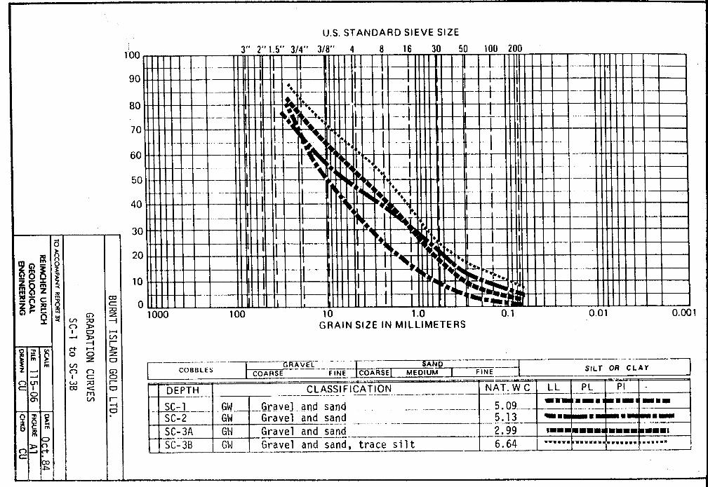
Gradation
Moisture contents were determined on representative sub-samples of SC-1 to 13
i n accordance with ASTM Designation D2216-71. They were computed as a percent-
age of the dry weight of the material by calculating the weight of water removed
in drying samples in an oven (Appendix, Figures A1 to A4). I t should be noted
tha t the samples were collected from trench exposures which are be t te r drained
than non-exposed so i l s . Therefore, the moisture values obtained should not be
considered representative of the en t i r e property.
Gradation t e s t s were completed on the same sub-samples in accordance with ASTM
Designation D422-63 for the purpose of providing mine equipment design data.
Distribution of larger par t ic le s izes was determined by washing each sample
through the No. 200 standard sieve (0.075 mm) and then drying and shaking the
remaining coarser material through the standard sieve s izes from 2.54 cm (1 i n . )
down to the No. 200. Samples were then c lass i f ied according to the Unified
Soil Classification System (Appendix, Figures A1 to A4).
8.0 SCROGGIE CREEK SURFICIAL GEOLOGY
8.1 Terrace Description
The Scroggie Creek terrace i s pronounced, and extends from near the creek mouth
to i t s head. The terrace i s mainly confined to the westward south side of the
valley. I t i s elevated 30 to 38 m (100 to 125 f t . ) above the valley bottom a t
the Walhalla Creek junction. Downstream of the junction, the slope of the terrace
i s less steep than the slope of Scroggie Creek and therefore the terrace increases
gradually in elevation above the valley bottom.
Our Autumn 1984 test ing program indicates tha t the bedrock surface underlying the
terrace surf ic ial deposits consists of two broad shallow channels up to 200 m (650 f t . ) wide.
REIMCHEN URLICH GEOLOGICAL ENGINEERING
EDMONTON VANCOUVER

Because of repeated freezing and thawing of the surficial deposits, bench materials near steep slopes are prone t o mass movement or solifluction. A
large area west of the tes t area i s influenced by this. Terrace deposits
adjacent t o the solifluction slope are partly covered and have been partly removed. The removed deposits end u p as coll uvium lower down on the slopes. Similar, b u t smaller scale movements have occurred elsewhere.
Gravel Description
The Scroggie Creek gravels, being of local origin, are mostly derived from gneissose rock. They are generally f l a t and tabular, and include sand, cobbles
and boulder sized particles. Many well-rounded granitic, pegmatitic and basic
(greenstone) cl asts a1 so occur. The terrace gravel s are call ed "bench gravel s" , and those on the floodplains o r the present valley floors "creek gravels". They
are typical stream deposits of average texture, with large boulders being rare.
Because of the high specific gravity of kyanite and garnet, pebbles rich in these minerals collect with the concentrates and occur in the heavy gravels which carry gold. This occurs especially along Mariposa Creek, and was re-
garded as an indicator of gold.
Creek Gravels
No creek gravels were tested during our testing program. Information on these
gravels i s therefore only available from past mining. In areas where they have
been explored, such as above the Scroggie-Walhalla Creeks junction, the creek gravels are shallow and usually overlain by t h i n overburden deposit. Depth t o
bedrock ranges from 1.8 t o 5.2 m ( 6 t o 17 f t . ) with 1 . 2 t o 2 .7 m ( 4 t o 9 f t . ) of gravel s.
Historically, gold distribution was found t o be erratic, being dependent n o t only on the retaining character of the bedrock, b u t on the bench deposits above. Significant amounts of go ld were always found opposite or just below a small tributary or slide from the bench, indicating that g o l d in the present creek
REIMCHEN URLJCH GEOLOGICAL ENGINEERING
EDMONTON VANCOUVER
gravels must have mostly originated from the bench gravels. Gold occurred mostly
on or i n bedrock, 0.3 to 0.9 m (1 to 3 f t . ) of which' was generally mined.
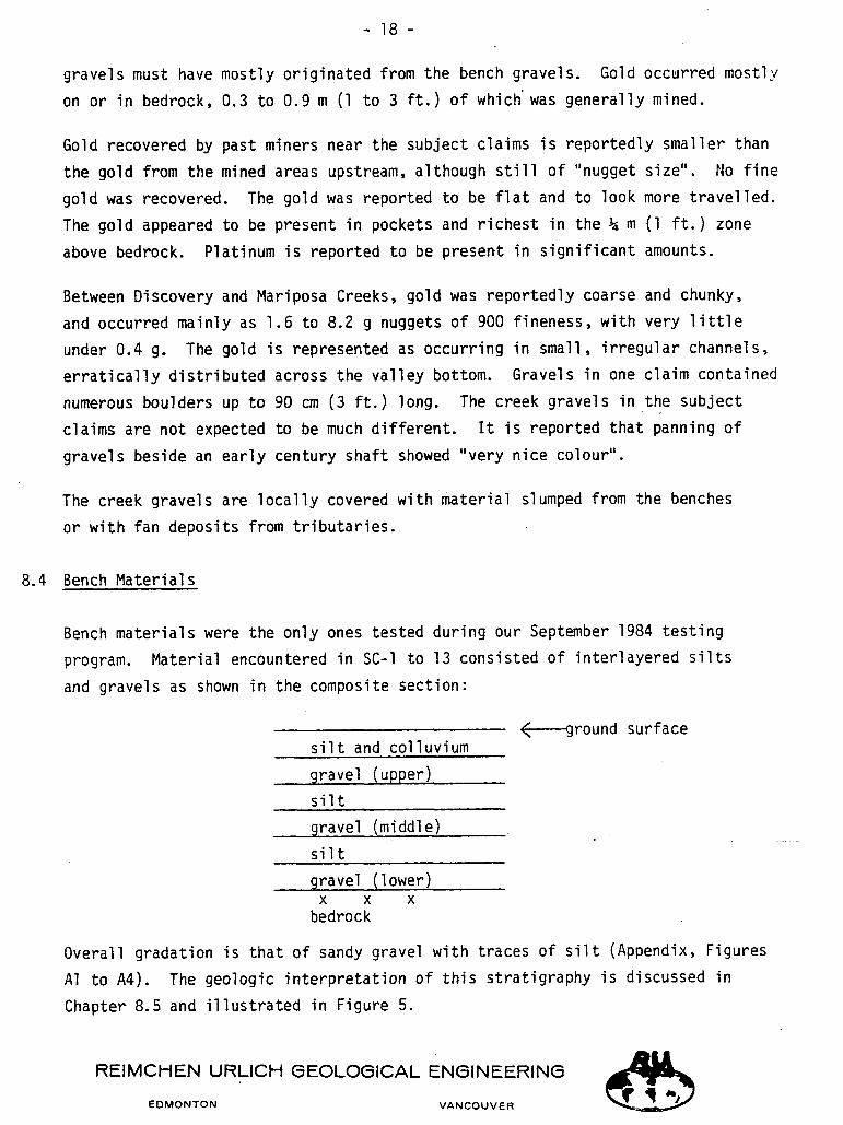
Gold recovered by past miners near the subject claims i s reportedly smalTer than the gold from the mined areas upstream, a1 though s t i l l of "nugget size". No f ine
gold was recovered. The gold was reported to be f l a t and to look more t ravel led.
The gold appeared to be present i n pockets and r ichest in the k m (1 f t . ) zone
above bedrock. Platinum i s reported to be present in s ignif icant amounts.
Between Discovery and Mariposa Creeks, gold was reportedly coarse and chunky, and occurred mainly as 1.6 to 8.2 g nuggets of 900 fineness, w i t h very l i t t l e under 0.4 g. The gold i s represented as occurring in small, i r regular channels,
e r r a t i ca l ly dis t r ibuted across the valley bottom. Gravels i n one claim contained
numerous boulders u p t o 90 cm ( 3 f t . ) long. The creek gravels in . the . subject
claims are not expected to be much different. I t i s reported tha t panning of
gravels beside an early century shaft showed "very nice colour" .
The creek gravels are locally covered with material slumped from the benches
or with fan deposits from t r ibutar ies .
8.4 Bench Material s
Bench materials were the only ones tested d u r i n g our September 1984 test ing program. Material encountered in SC-1 to 13 consisted of interlayered s i l t s
and gravels as shown in the composite section:
<-ground surface s i l t and colluvium gravel (upper) s i l t gravel ( m i ddl e )
s i l t gravel (1 ower)
X X X bedrock
Overall gradation i s tha t of sandy gravel w i t h traces of s i l t (Appendix, Figures A1 to A4). The geologic interpretation of t h i s stratigraphy i s discussed in
Chapter 8.5 and i l lus t ra ted in Figure 5.
RElMCHEN URLICH GEOLOGICAL ENGINEERING
EDMONTON VANCOUVER

A t least three gravel layers were observed in some trenches (SC-3 and' 3). Pinch-
ing o u t of individual s i l t and gravel layers occurs. The thicknesses of indivi-
dual layers varies from 0 t o 2.30 m (0 t o 7.5 f t . ) . The thickness of the whole
sequence from ground surface t o bedrock i s estimated t o average 3.5 m (12 f t . ) and the maximum thickness observed was 8 m (26 f t . ) in the excavation between
SC-9 and 10 (Figure 4) .
Most tes t trenches were collected from the terrace within Co-discovery claim P24882 and the adjoining.claims t o the north where a tributary enters Scroggie Creek (Figures 3 and 4 ) .
The s i l t layers are light brown t o grey in colour and range from s i l t t o sand in grain size. The s i l ty layers often contained sandy lenses and ..vice-versa.
The gravel layers are generally medium grained gravels having few clasts over 30 cm (1 f t . ) in diameter. The gravels are framework supported, show a poor preferred orientation, and consist of moderateiy t o well-rounded clasts. The
matrix of the gravels generally consists of sand and granules which are derived make u p the bedrock. Granule which from the breakdown of the intrusive rocks
rich lenses occur within the gravels. Th
relatively local origin.
i s indicates t h a t the gravels are of
All of the gravel layers are similar in nature w ' i t h the exception t h a t the upper layers contain a large proportion of light coloured granitic clasts,
while the lowest layers contain a greater proportion of dark coloured basic and schistose clasts. A tentative correlation between test locations suggests the presence of three gravel layers (Figure 5 ) .
To aid in identifying individual gravel layers in each hole, we have labelled
them the "upper", the "middle" and the "lower" layers (Table 1 ) .
8.5 Geologic Interpretation
O u r interpretation of a l l da t a obtained during this project i s that materials exposed i n al l test sites are facies of a t least three different units. ~ h e s e
REIMCHEN URLICH GEOLOGICAL ENGINEERING
EDMONTON VANCOUVER

units are river deposits consisting of gravels and s i l t s deposited by, single-
channel meandering rivers. Imbrication structures indicate flow directions to
the northwest. The three streams are superimposed as braided channels on each
.other (Figure 5) .
The s i l t y subfacies are overbank deposits laid down during periodic flooding
of the ancient floodplain. The gravels are point bar and channel deposits.
These materials were deposited in part by former Scroggie Creeks which flowed
along a wide floodplain extending across the Scroggie Creek valley and cut the
bedrock terrace which the gravels overlie. Simultaneously material was being
deposited in the tested area by the triqutary inmediately upstream in the forn~
of an alluvial fan (Figure 3 ) . The materials tested are therefore derived from
the Scroggie Creek drainage basin as well as from the smaller drainage basin of
the pup creek.
Lower Gravel s
The lower gravels are generally more s i l t y than sediments above and contain
angular pieces of the underlying bedrock. This unit averages 3 t o 4 m (10 to
13 f t . ) thickness, b u t ranges to 8 m (26 f t . ) . I t i s firm t o compact in density
and represents the oldest geological unit. The thickness and path of th i s unit
varies because of erosion by younger streams (middle and upper gravel).
3 Tests taken in th is unit ( sC-1 , 2 , 3A, and 13) range from $1.58 to $15.0S/yd . Because our t e s t plant only operated efficiently below 20 mesh, our recovery of
coarse gold was negligible. Because Herman Axel ' s former operation recovered most
of i t s gold in the 10 t o 40 mesh size, our values represent minimum values and
should be treated as such. The clean u p of the t o p 1 m (3 f t . ) of bedrock will
enhance grade as placer gold usually increases several magnitudes in th i s area.
Middle Gravel s
This unit i s only recognizable in some areas (SC-3B, 8, 10, 1 1 , 1 2 ) . I t tends to
consist of 1 ight coloured we1 1-washed materials, cross bedded materials, ranging
from sand t o cobble-size material. The erosional contact with the lower gravels . is
abrupt to transitional depending where you are. In Herman Axel ' s working (SC-9) the
REIMCHEN URLICH GEOLOGICAL ENGINEERING
EDMONTON VANCOUVER

REIMCHEN URLICH GEOLOGICAL ENGINEERING
EDMONTON VANCOUVER
boundary is defiried by boulders up t o 80 cm (2 .6 f t . ) i n long d iameter l y i n g
along a s cou r mark. In Trench 3 , t h e lower c o n t a c t i s def ined by a d i s con t inuous s i l t y l a y e r which has many o f t h e c h a r a c t e r i s t i c s o f a remnant pa leoso l ( a n c i e n t s o i l horizon) . The upper con tac t i s marked by an extremely we1 1 s o r t e d , horizon-
t a l 1 y bedded d e p o s i t o f r u s t y brown grave l s.
The middle grave l u n i t a l though a b s e n t i n some a r e a s can be up t o 2 m ( 7 f t . ) 3 i n th ickness . Gold va lues from this ma te r i a l range up t o Can$4.20/yd . In some
p l a c e s "ho t spo t s " will be 1 ocated a s i n SC-11. These a r e a s can o f t e n be recag-
nized by a 30 cm ( 1 f t . ) l a y e r of s i l t y g r a v e l . All o t h e r m a t e r i a l s have been
removed by l a t e r f l u v i a l e ros ion t h u s concen t r a t i ng the prec ious meta l s .
Upper Gravels
The upper grave l l a y e r i s l e s s than 2 m ( 7 f t . ) i n t h i cknes s averaging 1 t o 1 .5 m
( 3 t o 5 f t . ) . I t i s c h a r a c t e r i z e d by h o r i z o n t a l l y bedded r u s t y brown grave l s,
w i t h no angu la r p ieces of underlying bedrock. The pebbles a r e well-rounded. No
economic va lues a r e expected i n this u n i t a s can be observed by ou r tes t r e s u l t s
(SC-4, 5, 6 , 7 , 9 ) . In some p l aces upper g r a v e l s a r e intermixed w i t h a l l u v i a l
f an g r a v e l s depos i t ed by the t r i b u t a r y pup (F igu re 3 ) . Although gold can be re-
covered from these u n i t s , i t does no t appear t o be of economic cons ide ra t i on .
A1 1 uvi a1 Fan Gravel s
Th i s u n i t c o n s i s t s of s eve ra l f a c i e s ranging from s i l t y sands t o coa r se sand
g rave l . The ma te r i a l i s der ived from the unnamed t r i b u t a r y pup ( c r eek ) which
c u t s a c r o s s the Scroggie Creek bench (F igu re s 3 and 4 ) . E l sewhere i t c o n s i s t s
o f an unsorted mixture o f blocky angu la r bedrock t o wel l - sor ted sand and g rave l . Th i s mater ia l resembles s o l i f l u c t i o n o r c o l l u v i a l sediments depos i ted under a p e r i g l a c i a l o r permafrost environment. These m a t e r i a l s were not t e s t e d .
Scroggie Creek Gravel s
Th i s u n i t (F igu re 5) a1 though not p r e sen t on proper ty owned by 49-55 Yukon Ltd. n e v e r t h e l e s s r e p r e s e n t s a source o f f u t u r e economic gold. The Scroggie Creek
- 22 -
mater ia ls a r e derived from the erosion and washing of former old stream channels.
Although the creek i t s e l f has not been worked, economic values wil l be found i n
t h i s area.
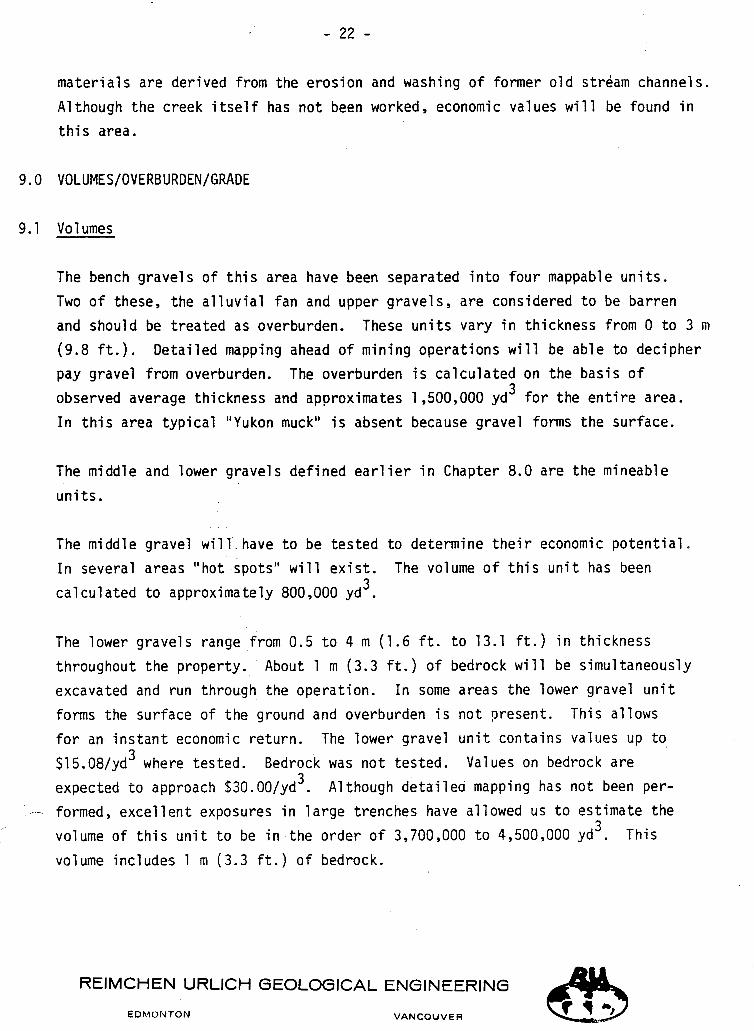
The bench gravels of t h i s area have been separated in to four mappable units.
Two of these, the a l luv ia l fan and upper gravels , a r e considered t o be barren
and should be t reated as overburden. These un i t s vary i n
(9.8 f t . ) . Detailed mapping ahead of mining operations w pay gravel from overburden. The overburden i s calculated
observed average thickness and approximates 1,500,000 yd 3
In t h i s area typical "Yukon muck" i s absent because grave
The middle and 1 ower gravel s defined ea r l i e r i n Chapter 8
un i t s .
thickness from 0 t o 3 m
11 be able to decipher
on the basis of
f o r the e n t i r e area.
forms the surface.
0 a r e the mineable
The middle gravel wi l l -have t o be tes ted to determine t h e i r economic po ten t ia l .
In several areas "hot spots" wil l e x i s t . The volume of t h i s uni t has been 3 calculated t o approximately 800,000 yd .
The lower gravels range from 0.5 t o 4 m (1.6 f t . t o 13.1 f t . ) in thickness
throughout the property. About 1 rn (3 .3 f t . ) of bedrock will be simultaneously
excavated and r u n through the operation. In some areas the lower gravel u n i t
forms the surface of the ground and overburden i s not ?resent . This allows
f o r an i n s t an t economic return. The lower gravel u n i t contains values up t o 3 $15.08/yd where tes ted. Bedrock was not t es ted . Values on bedrock a re
3 expected t o approach $30.00/yd . A1 though de ta i l ed mapping has not been per-
formed, excel lent exposures i n l a rge trenches have allowed us t o est imate the 3
volume of t h i s u n i t t o be in the order of 3,700,000 t o 4,500,000 yd . This
volume includes 1 rn (3.3 f t . ) of bedrock.
REIMCHEN URLICH GEOLOGICAL ENGINEERING
EDMONTON VANCOUVER

9.2 Grades
Our geo log ica l mapping and t e s t i n g has a1 lowed us t o s e p a r a t e "pay" grave l
l a y e r s from bar ren ground. Of cou r se t e s t i n g during mining o p e r a t i o n s will
determine i n d e t a i l what w i l l be c l a s s i f i e d a s overburden.
The economic grade o f a p roper ty i s on ly r e a l l y known a f t e r mining has been
performed. Our exper ience combined wi th t e s t i n g and knowledge o f t h e prev ious
o p e r a t i o n has allowed us t o make t h e fo l lowing conc lus ions :
( 1 ) Economic Mineable Ground - 3,700,000 t o 4,500,000 yd3 a l lowing f o r 1 m (3 .3 f t . ) o f bedrock
(2) Recoverable gold and platinum a l lowing f o r 910 f i n e n e s s will average
between Cans8 and ~ a n $ l ~ / ~ d ~ based on a go1 d p r i c e o f Can$450.00/01. ($337.00 U.S.) p r i c e s
( 3 ) Overburden w i l l approach 2,500,000 ~ d ' .
3 ( 4 ) Mining c o s t s inc lud ing overburden removal should no t exceed $5.50/yd .
10.0 MINING CONSIDERATIONS
10.1 H i s t o r i c a l Review
Since 1980 t h e r e has been a resurgence i n gold p l a c e r s t a k i n g i n a l l a r e a s o f
North America. Most a c t i v i t y has occurred i n t h e h i s t o r i c Klondike/Dawson,
Car iboo/Barkerv i l le and Ca l i fo rn i a a r e a s . Within these r eg ions ground prev ious ly worked by miners more than a cen tury ago has been r e s t aked . Mining, o f t en on a l a r g e s c a l e involv ing severa l hundred cub ic ya rds per hour, i s occu r r ing wi th
va r ious degrees o f mediocre recovery. The reason f o r t h i s l i e s mainly w i t h
tec hnol ogy .
Machinery capable of moving l a r g e volumes o f sand and grave l has been improved
in t h e l a s t cen tury . Gold recovery techniques however have no t kept pace wi th
t h i s improved m a t e r i a l s handling technology. S l u i c e boxes, no m a t t e r how e f f i c i e n t , w i l l only recover p l a c e r gold p a r t i c l e s i n volume down t o 60 mesh
REIMCHEN URLICH GEOLOGICAL ENGINEERING
F DMONTON VANCOUVER

(0.25 mm) in size. Early miners were a1 lowed to recover f ine gold by placing
mercury i n a few of the i r s luice box r i f f l e s . This procedure i s now banned in
most parts of the ear th for obvious environmental reasons.
In the l a s t decade there has been an attempt to improve recovery of f ine gold which often comprises more than 90% of the to ta l gold. Some of these techniques
involve centrifugal concentrators such as spinning barrels and hydrostatic
cones which ro ta te about horizontal and vert ical axes, respectively, and a re capable of gold recovery to about 500 mesh (0.03 mm). Other devices include
j igs capable of sustained recovery to about 100 mesh (0.15 mm) and recently reported from Alaska to recover to 300 mesh (0.05 mm). A cyclonic method of
recovery presently under testing by Reimchen Urlich has proven capable of recovery to 15000 mesh (1 micron or 0.001 mn) .
Recovery Cri ter ia
Recovery of f ine gold part ic les i n sluicing and tabling operations is adversely
affected by surface tension when part ic les suspended i n water are exposed to a i r . Fine gold and large flakes of f l a t gold f l o a t i n water and completely wash away
in s luice and other gravity type concentrators. Forces tha t cause these par t ic les
to f loa t or to remain i n suspension can be overcome e i ther by the addition of chemical surfactants or by centrifugal accelerations imparted to the par t ic les as they pass through specially designed concentrators. Large scale use of
chemical s i s expensive and environmental ly sensit ive. Centrifugal concentrators
are practical and are i n limited use today.
The geological depositional environment bnd s ize of gold part ic les m u s t be tested and calculated before mining equipment i/s obtained. According to our recent
tes t ing of a nearby Barker Creek property, 30 to 37% of the placer gold was not recovered by a conventional s luice box. l These a re minimum figures and are
probably higher in areas where sand layers predominate over gravel. The same
figures would apply a t Scroggie Creek. Therefore mining and recovery equipment
should be designed and selected to recover gold part ic les to a t l eas t 300 mesh (0.05 mm).
REIMCHEN URLICH GEOLOGICAL ENGINEERING
EDMONTON VANCOUVER

We cons ide r t h a t t h e b e s t a v a i l a b l e and proven type o f c o n c e n t r a t o r s u i t a b l e
f o r recover ing gold from t h e Scroggie Creek p l a c e r s i s t h e sp inning b a r r e l .
Th i s conc lus ion is based on ou r p a s t work wi th s eve ra l concen t r a to r s on t es t
and product ion s c a l e s , and wi th ou r p r e s e n t eva lua t ion o f t h e Scroggie Creek
p lace r s .
10.3 Spinning Bar re l Concent ra tor
Our expe r i ence wi th sp inning ba r r e l test p l a n t s i nc ludes e v a l u a t i o n s o f s e v e r a l
p r o p e r t i e s i n t h e United S t a t e s and Canada inc luding Scroggie (F igu re 6, upper
photo) . O u r expe r i ence on a production l eve l inc ludes mining and gold recovery
on a 6-bar re l p l a n t nea r A t l i n during t h e sumner o f 1983 (F igu re 6 , lower pho to ) .
We a s s i s t e d w i th t h e des ign o f an 8-bar re l p l a n t which was o r i g i n a l l y scheduled
f o r Yukon work but i s now being mobil ized t o L i l l o o e t f o r gold mining and pro-
duc t i on.
The Scroggie t e s t p l a n t and t h e two product ion p l a n t s were b u i l t by S c o t t
Mas te r f lex ( F a b r i c a t o r s ) Ltd. o f Maple Ridge. The product ion p l a n t s c o n s i s t
o f 20-inch d iameter and 8.5 f t . long primary concen t r a t i on b a r r e l s and a s i n g l e
12-inch d iameter and 5 f t . long secondary concen t r a t i on b a r r e l . All b a r r e l s
a r e b u i l t o f Schedule 40 p ipe with c i r cumfe ren t i a l r i n g s and l o n g i t u d i n a l r i b s
welded t o t h e i r i n s i d e wa l l s . These a i d i n t h e c o l l e c t i o n o f about 5.2 f t . 3
o f primary c o n c e n t r a t e f o r each 20-inch b a r r e l and 1.0 f t . 3 o f secondary con-
c e n t r a t e i n each 12-inch b a r r e l .
According t o Mr. George S c o t t of S c o t t Mas te r f lex , t h e A t l i n 6-bar re l p l a n t was
o r i g i n a l l y a 2-bar re l p l a n t ope ra t i ng a t Manson Creek. I t was r e b u i l t i n 1983 3 f o r A t l i n and designed t o process 150 t o 200 yd / h r o f i n s i t u ma te r i a l o r 25 t o
3 33 yd / h r pe r b a r r e l . Up t o 30 t o 40% o f t h i s volume would be processed through - -
t h e b a k e 1 s fo l lowing screening o f f o f o v e r s i z e m a t e r i a l . Thus each 20-inch ba r r e l 3 i s capable o f p rocess ing 1 0 t o 15 yd / h r o f screened unders ize . These des ign
r a t e s were achieved i n A t l i n dur ing good working cond i t i ons .
The a c t u a l r a t e depends on t h e screen s i z e which could range from 3/16 t o 3/8-
inch. The l a r g e r mesh would enable more mater ia l t o pass through t h e b a r r e l s ,
RElMCHEN URLJCH GEOLOGICAL ENGINEERING
E D M O N T O N VANCOUVER

b u t would lower the efficiency of fine gold recovery. A finer mesh adds to the
material handling cost, b u t increases the gold recovery efficiency. A 5/32-inch
screen has been bui l t into the 8-barrel plant designed for the Yukon. I t s 3 owner anticipates mining u p to 450 yd / h r of insitu material. .
10.4 Concentration Operation
Following washing and screening off of oversize particles, undersize material i s slurried through a closed end of the horizontal 20-inch spinning barrels a n d
out the open end. As th is slurry passes t h r o u g h , centrifugal forces within the
barrel generate an acceleration which forces heavy particles to the wall and
traps them as a fluid bed between the ribs and rings. As feed continues,
lighter particles in th is bed are replaced by incoming heavier ones and gold i s concentrated. Thus there i s very l i t t l e wear on the barrels because the material
particles wear against each other.
For clean up , the feed i s stopped and water passed t h r o u g h until i t emerges
clear from the open end while the barrel remains spinning. The spin rate i s
then slowed and 5.2 f t S 3 of primary concentrate collected from each barrel for
secondary processing through the 12-inch barrel. Once the primary concentrate
has been passed through the secondary barrel, the same clean u p process follows and the resultant 1 f t .3 of secondary concentrate collected.
According to George Scott, the power requirement for a concentrating plant, complete with grizzly, screens and feeder can be based on 7.5 and 3.0 HP for each 20 and 12- inch barrel , respectively .
10.5 Security
While in operation the barrels spin in excess of 150 rpm. Thus i t i s not
possible to identify gold particles within the barrels during operation, l e t alone pick them out. Indeed, an attempt by an individual to remove material
from within a barrel while spinning would result in severe damage to the hand.
REIMCHEN URLICH GEOLOGICAL ENGINEERING
EDMONTON VANCOUVER
Clean ups should be s t r i c t l y supervised by an owner's representative. ' The
resu l tan t 1 f t . 3 of secondary concentrate should be delivered promptly t o a
secured gold room f o r gold extract ion. Thus secur i ty around the plant can be
e a s i l y controlled and presents l e s s opportunity f o r t h e f t than a conventional
s l u i ce operation.
EXECUTIVE SUMMARY
Field t es t ing of placer ground on Scroggie Creek, 100 km (62 miles) south of
Dawson, Yukon Terr i tory , has resulted in the delineation of between 3,700,000 3 and 4,500,000 yd of economic gravel.
These gravels which a r e s i tua ted on a high bench above Scroggie Creek, a r e the
remains of r i v e r s which flowed a t roughly the same time as the "White Channel"
gravel s around Dawson .
The overall grade of t h e Scroggie Creek placer ground under option t o B u r n t 3 Island Gold Ltd. i s between Can$8 t o $lO/yd (U.S.$337.00) allowing f o r 910 fineness.
3 A min imum net p ro f i t of $3.00/yd can be achieved i f mining u t i l i z i n g centr i fugal
recovery i s practiced.
No permafrost will e x i s t in the gravels f o r the f i r s t two mining seasons. The
reason fo r t h i s i s t h a t previous operations cleared overburden and vegetation
from an area measuring 1000 m (3300
NEERING
Cecil M. Urlich, P.Eng. Partner
*
REIMCHEN URLICH GEOLOGICAL ENGINEERING
EDMONTON VANCOUVER

C E R T I F I C A T E
I, Ted H. F. Reimchen, of 5571 Cove Cliff Road, North Vancouver, B. C. Canada, do hereby certify that:
I am a graduate of the University of Alberta, graduated with a B.Sc. Degree in Geology and Zoology in 1964, and with a M.Sc. Degree in Geology in 1966.
I have been registered as a professional geologist since 1971 by the Association of Professional Engineers, Geologists, and Geophysicists of A1 berta.
I am a member of Canadian Institute of Mining and Metallurgy, Society of Qua ternary Geol ogi sts, American Society of Photogramnetry, Canadian Remote Sensing Association, and Canada/United States Radar Satellite Study Team.
I have practised as a consulting geologist since 1968, and have been a partner of Reimchen Urlich Geological Engineering since 1982.
I have no interest in any claims or properties owned by Burnt Island Gold Ltd. of Vancouver.
I do not express any guarantee or warranty. The report is based on facts resulting from personal investigations and from investigations completed and reported by staff of Reimchen Urlich Geological Engineering, and comnercial testing laboratories.
I hereby consent to the use of the report by the Company in connection with a prospectus, or a statement of material facts relating to the raising of funds for the project.
Dated at the District of North Vancouver, in the Province of British Columbia, this 11th day of October, 1984.
Respectfully submitted,
Ted H. F. Reimchen, P.Geo1. - -.
REIMCHEN URLICH GEOLOGICAL ENGINEERING
EDMONTON VANCOUVER

C E R T I F I C A T E
I , Cecil M. Url ich, of 1425 Jef ferson Avenue, West Vancouver, B. C., Canada, do hereby c e r t i f y tha t :
I am a 1972 graduate of the Universi ty of Calgary, A1 ber ta , graduated with a M.Sc. Degree in Geotechnical Engineering, and a 1970 graduate of the Universi ty of Auckland, New Zeal and, w i t h a B.E. Degree i n Engineer- ing Science.
I have been reg i s t e red a s a professional engineer s ince 1977 by the Assoc- i a t i o n o f Professional Engineers of B r i t i s h Columbia, and s ince 1982 by t h e Association of Professional Engineers, Geologists , and Geophysicists of A1 be r t a .
I am a member of Canadian Geotechnical Society and American Society of Ci vi 1 Engineers.
I have been involved in consult ing geotechnical engineering s ince 1972, and have been a par tner of Reimchen Urlich Geological Engineering s i n c e 1 982.
I have no i n t e r e s t i n any claims o r proper t ies owned by Burnt Is land Gold Ltd. of Vancouver.
Conclusions obtained and reported during my work a r e based on f a c t s re- sul t ing from personal inves t iga t ion and from i n v e s t i g a t i o n ~ completed and reported by s t a f f of Reimchen Urlich Geological Engineering and c o m e r i c a l t e s t i n g l abora to r i e s .
Dated a t the D i s t r i c t of North Vancouver, in the Province of B r i t i s h Col umbi a , t h i s 11 t h day of October, 1984.
Respectful ly submitted,
Cecil M. Url ich, P.Eng.
REIMCHEN URLICH GEOLOGICAL ENGINEERING
EDMONTON VANCOUVER
1 - We hereby certify that the following am the results ot 1-1:
General Testing Laboratories A Division of SGS Supervision Services Inc.
submitted Placer gold
TO:
BEIMCHElQ URLICH GEOLOGICAL k=NGINEERR?G 4381 Gallant Ave., N. Vancouver, B.C. V7G 1L1
- i z- MARKED
1001 EAST PENDER ST.. VANCOWER. B.C.. CANADh W A 1W2
PHONE (804) 254-1 647 TM( OeS07514 CABLE: SUP-
TABLE A1 CERTlFICATE OF ASSAY
OF CONCENTRATES I*.: 84109250 B I DATE Oct. 3/84 1
of Placer Gold Concentrates:
: 'rE: EJECTS RETAINED ONE MONTH. PULPS RETAlNOD THREE MONTHS. ON REQUEST AND RLECTS WILL BE STORE FOR A MAX- OF ONE YEAR.
-
AnalVricslr Md Cons~Ithg Chemists, Bulk cargo specialists, sum yo^^, Inspec- samplers, weigbm


r l General Testing Laboratories - A Division of SGS SU-pwision Services Inc.
1001 EAST PENOER ST.. VANCOWER B.C.. CANADA, V6A 1 W2 PHONE (804) 254-1647 TELEX 04507514 CABLE: SUPERVlSE
ILEIPEHEN URLICH GEOLOGICAL TABLE A3
438 1 Gallant Ave , , CERTIFICATE OF ASSAY
*- We hereby certify that the following are the results of assays on: Cha;rse Pulp8 - P.0- NO, 1 1
M. Vencauver, B.C, V7G 1L1
7UTAL CONC.
g
1063.2
1130.0 1964.5 1385.5 1447.4
754.2 1157.1 1255.1 1717.9
OF CONCENTRATES [NO.: 8 4 1 0 - O ~ ~ D A T E : Oct. 3/84 1
GOLD
ol;/st
AVERAGt GOLD o z l s t
1 Concentrates: Total
Weight (s-4
SC-I 518.2 SC-2 1132.6 -3 554.1 =-3 1 0 0 0 ~ 7 a -4 691 .5 =-5 770.4
*qTE REJECTS RETAINED OK MONTH PULPS RETAINED THREE MONTHS. ON RMUEST RllPS
a AND REJECTS WILL BE STORE FOR A MAXIMUM OF ONE YEAR.
Analytic81 and Consulting Chemists. Bulk Cargo Specialists, Surveyors, Inspectors, Samplers, Weighers

a1 lesmg ~a- sion of SGS Supervision Services Inc.
- - 1001 EAST PENMR ST. VANCOWER, RC.. CANAOh V6A 1WZ
CERTIFICATE OF ASSAY OF CONCENTRATES
I I I
I T O : - - 7 URLICH GWLOGICBL mu-
.'
% -
PHONE (604) 254-1647 T M ( 04507514 CABLE SUF'FRVSE
TABLE A4 Hlsmu
m T n -rim
4361 G a l l a n t Ave. , H, Vancouver, B.C. V7C 1T.I
Coarse Pulps
. ,- .-.
r We hereby certify that the following are the results of assays on:
1~0.: 8410-0351 A 1 DATE: Oct. 4/84
GOLD
oz/a t GOLD
MARKED
o z l t o n
F i l e NO. 11 5-06
Concen- Total t r a t e s : Wei&t
(gr-1
SC - 11 296.3 SC - 12 748.1 sc - 13 305.7 sc - 14 369.7 sc - 15 789.3 s c - 1 6 93.3
- 17 249.5 sc - 18 1032.6 Add t o SC-1
NOTE REJECTS RETAHED ONE MONTH. PULPS RRAlNED THAD MONTHS. ON REQUEST I'ULPS LA AN0 AEJECTS W U BE STORE FOR A MAXIMUM OF ONE YEAR.
I PORTS ARE THE CONFIOENTIAL PROPERM OF ClJtENTS R s u T l O N OF STATE-MEKn CONCLUSION OR €XIPACTS FROM OR REGARDtNG OUR REPORTS IN NOT PERMflTED WITWUT OW W R ~ APPROVAL ANY UABUN A ~ A C H E D THEAEFO IS U M ~ D TO THE m cnm-
/ /
PRWCV\L ASSAVG-J -- .-.
Analytical and ConsuIting Chemists, Bulk Cargo Specialists, Surveyors, Inspectors. Samplers, Weighers M: Amencan Socwly Fa Tmtmg Matenab 0 The human Chi Chmgts Socmly 0 t2mdl.n Tm.tng B m
REFEREEANDOilOFHCULCMMSTSFCU N.1- b t ~ M e d O d & R O b C t r 0 The-OLCh.mots'S~cl.(y WFICUL WEK3HuASERS FOR. V W U B o d Q( T f e

. We hereby certify that the following are the results of assays on: Coarse Pulps
.-- I A Division of SGS Supervision Services Inc.
File 11- Concentrates :
NO= ROKSTS RETAINED ONE m. PULPS RETAINED THREE MONTHS. ON REQUEST PULPS , AN0 AOECTS WILL BE STORE FOR A MAXIMUM OF ONE YEAR.
1 Wl EAST PENDER ST. VANCOWER. B C . CANADA V8A 1 W2
W N E (604) 254-1 647 TELM 04-50751 4 CABLE SUPERVISE
TABLE A5
CERTIPICATE OF ASSAY OF CONCENTRATES
1 . : 8410-0L53 IDATE: Oct, l0/84 I 61 . - - . SG*
I E M S ARE THE CONFlMNTlK mPERW OFCLIENTS PUBUCATON OF STATE-WE L, .,LUSION OR MTFUCTS FROM OR REGARMNG OUR REPORTS IN NOT PERMmD WITHOUT OUR WRfTTEN APPROVAL ANY LlABll lM AITACHED THERETO IS UMmD TO THE FEE CHARGED.
/ /
TO: BEIKHEN URLICH GEOLOGICAL
EM;- 4381 Gallant A v e , North Vancouver, B,C. V7G 1Ll
U.S. STANDARD SIEVE SlZE
- -
GRAIN SlZE IN MILL IMETERS
pp
---- -- - -- - -- - - - - - TRAVEL-- - L- S A k O
COBBLES COARSE FINE l c o ~ R s ~ l MEDIUM I FINE-r ~ , L T OR C L A Y ---
r
DEPTH -- CLASS1 FICATION _ _ _ __ ----- ---
. SC-l--_-. GW Gravel and sand - --- - - 5.09 _--- SC-2 GW Gravel and sand - - - - - - - - -
SC- 3A GW Gravel and sand I SC-3B GW L Gravel and sand , t r a c e s i 1 t 6.64 n w w ~ w I W W C I I ...s.B
*- - - --

U S. STANDARD S I E V E S I Z E I
GRAIN S l Z E IN MILLIMETERS

U.S. STANDARD SIEVE SlZE
GRAIN SlZE IN MILLIMETERS
- . -. . - . - - __ _ _- . . . . - -._ - SAND s,Lr OR C L A Y .
-- --
NAT. W C LL I . PL I PI - ---- --.-- --
Gravel and .sand. . . - - - - -. - - - - . - - -. - 3 62 . - . - I - - - . - . - . . . . - 1
6.62 - ---

U.S. S T A N D A R D SIEVE S l Z E
10 1 .o 0.1 G R A I N S l Z E IN MILLIMETERS
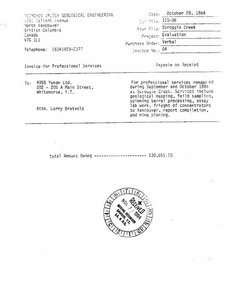
' iorth Vancouver 3 r i t i sn Columbia Canada V 7 G 1L1
Telephone: ( 6 9 4 ) 929-2377
2: t ? : October 28, 1984 - - . - . - -
y33r ~ i ; . -- Scroggie Creek -
? r o j p c t : Eva1 u a t i o n
Purcq3se Order:
Invo i ce f o r Prof ess i onai % r v i ces P a y a b l e on Receipt -. -- -. -- - -
TO: 4955 Yukon L td . 202 - 205 A Main S t ree t , Whitehorse, Y .T.
A t t n . L a r r y B ra tvo l d
For p ro fess iona l serv ices render ed dur ing September and October 1984 d i SLI "yY ;e C i - ~ e k . SET*;;C=Z 'nc!ude geol o5i ca1 mapping , f e i 1 d sampl i rtg , sp inn ing b a r r e l processing, assay l a b work, f r i e g h t o f concent ra tors t o Vanco~ver , r e p o r t comp i le t i on , and mine p lan ing .