Embed Size (px)
Citation preview
REPORT ON
For ofliclal use only
INVENTORY OF TREES IN NONFOREST AREAS
A PILOT SURVEY IN 25 VILLAGES OF
WEST BENGAL
FOREST SURVEY OF INDIA EASTERN ZONE
CALCUTTA 1997
PREFACE
Forest Survey Of India, for, the first time took up inventory surveys in the rural areas with the primary objective of assessing the distribution of trees and the Growing Stock in the rural areas arid to have an overview of the va rious social forestry schemes imp~emented by the State Forest Departments. The inventory survey was carried out accordin~ ~o random sampling methodology. One of the
.important point in this survey was to categorise various types of trees in a village. The categories were farm forestry; 'j-b'adside p lantations, village woodlots, block plantations, plantations done along cahals, rai lway lines, ponds and others, This report, prepared by Eastern Zone, Calcutta, pertains to pilot survey undertaken in 25 villages of West Bengal State,
The purpose of the pilot survey was to determine the optimum sample s ize for the state for the main survey. During the course of conducting the pilot survey a lot of data. regarding tree species, their categories and their diameter were collected.
The geographical area of West Bengal state is 88752 sq.l<.rn. Tile lotal nonforest area of the state is 76873 sq.kms. During the pilot survey of 25 villages the total coverage of survey area was 49.44 sq.km, Out of the total species inven'toried, 43 species on the basis of their predominance and commercial importance have been presented separately. Other species have been grouped together as miscellaneous,
The total number of trees enumerated were 1,25,634 i.e, 25.41 trees I ha. Miscellaneous species has been found to have the largest representation with 27% trees followed by Mangifera indica(12%), Eucalyptus species (11 % ), Acacia auriculliformis (10%), etc.
The inventory survey and data processing work was carried out by Forest Survey Of India, Eastern Zone, Calcutta and Headquarters office Oehradun. The worl< of the field staff and officers who were associated in carrying out the inventory survey, data processing and writing of this report, is appreciated. It is hoped that this report will be of use, not only to the State Forest Department of West Bengal but also to others.
( Dr. S.N.Rai ) Director.
CONTENTS
Para Page No. No.
CHAPTER: I INTRODUCTION AND DESCRIPTION OF DISTRICTS
INTRODUCTION 1.1 1 SITUATION AND BOUNDARIES 1.2 1 PHYSICAL FEATURES 1.3 1 CLIMATE 1.4 2 ANNUAL RAINFALL 1.4.1 2 MAXIMUM AND MINIMUM TEMPERATURE IN WEST BENGAL 1.4.2 3 RIVER SYSTEM 1.5 3 AGRICUL TURE 1.6 4 INDUSTRY AND MINERALS 1.7 4 IRRIGATION AND POWER 1.8 5 FORESTS 1.9 5 DISTRICTS 1.10 6 DISTRICTWISE AREA, POPULATION & POPULATION DENSITY(1991 CENSUS) 1.11 6
CHAPTER: II DESIGN AND METHODOLOGY
OBJECTIVE 2. 1 7 . SAMPLING DESIGN 2.2 7
DATA COLLECTION 2.3 8 CATEGORIES OF PLANTATION I TREES 2 .4 9 DATA PROCESSING 2.5 10
. AGRO-ECOLOGICAL REGIONS OF WEST BEN GAL 2.6 10

- ii -
CHAPTER : III RESULTS OF THE SURVEY
TREES COMMONLY MET WITH PER HECTARE DISTRIBUTION OF TREES BY DIAMETER CLASS AND CATEGORIES OF TREES NUMBER OF TREES
TREES SPECIES FOUND IN VARIOUS AGRO-ECOLOGICAL REGIONS OCCURRENCE OF BAMBOO
BIBLIOGRAPHY
MAP:
DISTRIBUTION OF SAMPLE VILLAGES OF WEST BENGAL ACCORDING TO AGROECOLOGICAL ZONE.
TABLES
Para Page No. No.
3.1 12
3.2 12 3.3 15
3.4 15 3.5 16
18
19
1 - 8 nos.
( jii )
LIST OF TABLES
Table No. Particulars Page No.
Table No. 1. Distribution of Stems by Diameter Class (in cm.) and Species in 25 Villages of West Bengal. 20 (All Categoriescombined)
Table No. 2. Distribution of Stems by Species and Categories in 25 Villages of West Bengal. 21 ( ~J Diameter Class combined)
Table No. 3. Distribution of Stems by Diameter Class (in cm.) and Category in 25 Villages of West Bengal. 22 (All Species combined)
TabJe No. 4. Distribution of Stems by Species in various Agro Ecological zones in 25 villages of West Bengal. 23 (All Diameter class & Categories combined)
Table No. 5. Distribution of Stems by Species and districts in 25 villages of West Bengal. 24
Table No. 6. (All Diameter class & Categories combined) Abstract showing the villages surveyed in dif1crcnt districts with population, area ecological zone and number of trees enumerated. 25
Table No. 7. Botanical name and local name of the species used in the report. 26
Table No. 8. Data used for sample size determination. 27
BAR CHARTS 1. No. of stems per hectare by Categories. 28
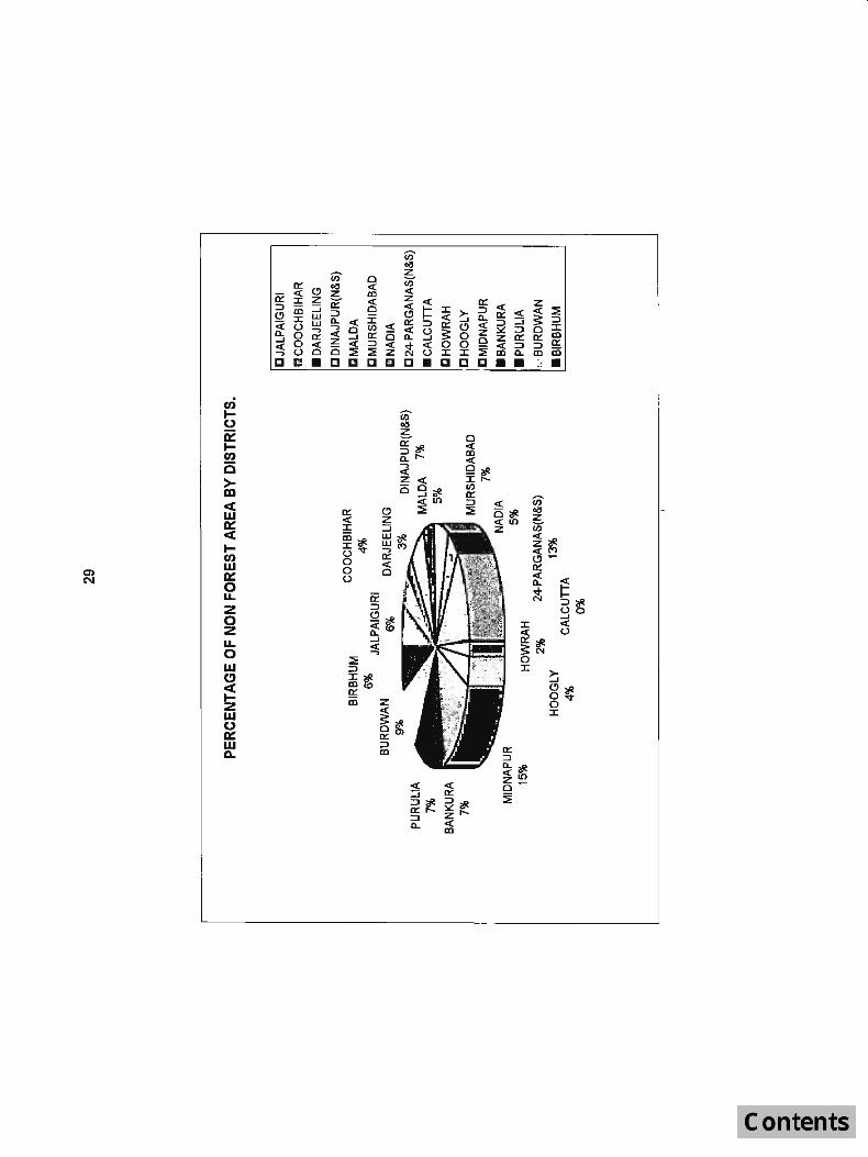
PIE - CHART 1. Percentage afNon-forest Area by Districts. 29

CHAPTER: I
INTRODUCTION AND DESCRIPTION OF DISTRICTS
1.1 INTRODUCTION:
·West Bengal occupies a crucial place in India by virtue of its unique location within three international frontiers. Its rich variegated cultural pattern and dynamism has always fascinated people both at home and abroad. The present report in respect of the inventory of non-forest areas is the first venture of its kind. The results appended below are based on a pilot survey of 25 villages distributed over various agro-ecological regions of the State of West Bengal conducted during the period 1991- 1993.
1.2 SITUATION AND BOUNDARIES:
The State is bounded on the east by Bangladesh and Assam, on the west by Bihar and Orissa, on the north by Nepal and Bhutan and on the south by the Bay of Bengal. It is located between 21°30'N and 27°12'N latitudes at the head of the Bay of Bengal and between 85°50'E and 89°52'E longitudes.
1.3 PHYSICAL FEATURES =
West Bengal's physiography has two natural divisions : the Himalayan nortl, and the fertile alluvial Gangotic plain stretclling to its soutll. Tilo lopogrDplly of the northern territory varies from a maximum elevation of 3660 metres at Sandakphu in Oarjeeling district to an elevation of 89 metres in the low- lying areas in Jalpaiguri and Cooch Behar districts, watered by the swift-flowing rivers like Teesta, Torsa and Jaldhaka.The deltaic structure at the Sundarbans estuary is another feature of interest. In the south-west, the land gets more and more slopey and undulating, ultimately merging into the Chotanagpur plateau structure in Purulia district.

1.4 CLIMATE:
Moist wind from' the Bay of Bengal makes the climate of the State highly humid, specially in the rainy season; but in cold weather, from September to February, the climate over the entire State is exceedingly pleasant.
1.4.1 ANNUAL RAINFALL:
Actual -> Normal 1991 1992
Sub-Himalayan WestBengal :
Darjeeling 3212 3810 3843 2729 JaJpaiguri 4136 3434 3903 2820 Coocll Behar 3193 3157 3064 2354 Dinajpur(N&S) 1802 2377 2186 1523 Maida 1498 1526 1940 1294 Gangetic West Bengal:
Murshidabad 1338 1538 1429 1030 Nadia 1401 1685 1386 1071 Birbhum 1234 1542 1348 1069 Burdwan 1271 1557 1443 1019 Hooghly 1516 1571 1845 1057 Bankura 1271 1640 1587 1149 Purulia 1365 1811 1231 1267 Midnapore 1428 2152 1584 1466 Howrall 1676 1953 1651 1210 24-P arg anas(N&S) 1579 2208 171 8 1493
Source:·1. Directorate of Agriculture, Agricultural Meterological Secrion, GovLor West Bengal. 2 . Meteorological Department,GoYLof India, 3. Economic Review ,1993-94, Govl.of West Bengal. 4. Statistical Hand Book, 1992, Govl.or West Bengal.
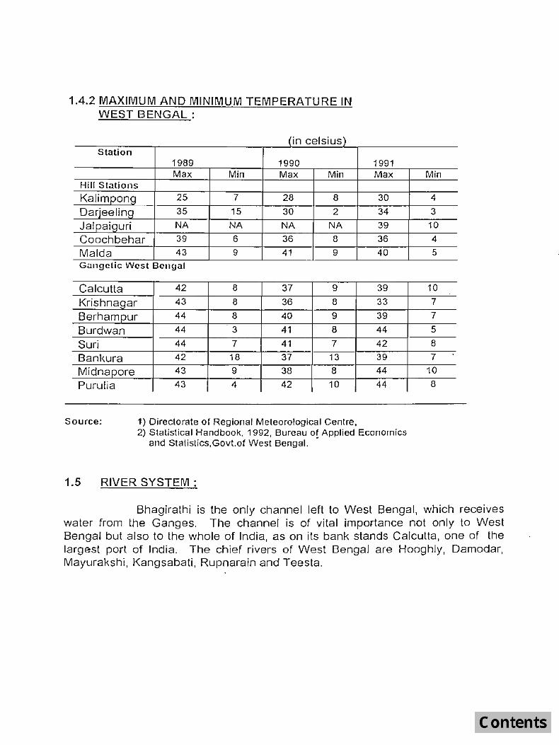
1.4.2 MAXIMUM AND MINIMUM TEMPERATURE IN WEST BENGAL:
(in celsius) Station
1989 1990 Max Min Max Min
Hill Stations
Kalimpong 25 7 28 8
Darjeeling 35 15 30 2
Jalpaiguri NA NA NA NA Coochbehar 39 6 36 8
Maida 43 9 41 9 Gangetic West Bengal
Calcutta 42 8 37 9
Krishnagar 43 8 36 8
Berhampur 44 8 40 9
Burdwan 44 3 41 8
Suri 44 7 41 7
Bankura 42 18 37 13
Midnapore 43 9 38 8
Puru!ia 43 4 42 10
Source: 1) Directorate of Regional Meteorological Centre,
1991 Max
30
34
39
36
40
39
33
39
44
42
39
44
44
2) Statistical Handbook, 1992, Bureau of Applied Economics and Statislics,GovLof West Bengal. •
1.5 RIVER SYSTEM:
Min
4
3
10
4
5
10
7
7
5
8
7
10
8
Bhagirathi is the only channel left to West Bengal, which receives water from the Ganges. The channel is of vital importance not only to West Bengal but also to the whole of India, as on its bank stands Calcutta, one of the largest port of India. The chief rivers of West Bengal are Hooghly, Damodar, Mayurakshi, Kangsabati, Rupnararn and Teesta.
1.6 AGRICULTURE
Agriculture plays a pivotal role in the state's income and nearly three out of four persons in the State are directly or indirectly involved in agriculture. About 45 per cent of the gross cropped area of the state has been brought under irrigation. With an area of 5,719 thousand hectares, rice production went up to 11,954 m. tonnes in 1991-92. The State occupies a leading position among the principal rice growing states of India by contributing 16.2 per cent of the total production of rice. The total foodgrain production has attained an all time record production of 128 lakh tonnes in 1991-92. The State accounted for 63.4 per cent of the country's jute, including mesta, in 1991-92 and 21.8 per cent of tea production in 1991 (calendar year). Other important crops, include potatoes, oiJseeds, betel-vine, tobacco, wheat, barley and maize.
1.7 INDUSTRY AND MINERALS:
West Bengal was one of the major industrial States in tile country with 8,900 registered working factories in 1990. The number of small scale industrial units registered with the Directorate of Cottage and Small Scale industries during 1991-92 stood at 27,434. Besides the alloy steel plant at Durgapur, there are two more steel plants, one at Durgapur and twenty three other mini steel plants in the state,and the other in Burnpur, both located in the Burdwan district. Major industries, among others, include engineering, automobiles, chemicals, pharmaceuticals, aluminium, ceramics, leather, footwear, bonemeal, bicycle, jute, cotton, textiles, tea, paper, glass and timber-processing. '. In addition, central public sector undertakings including coal, locomotive, cable, fertilizer, shipbuilding and ordinance factories are located within the State. The State Government in its turn has set up public sector undertakings like tea, fruit and vegetable processing, sugar, dairy and poultry, chemicals and phytochemicals, agro-textile, sugarbeet, silicate and glass, plywood, electro-chemical, electro-medical and allied industrial development, including mineral development. Coal and china clay are two important minerals found extensively in the State.

1.8 IRRIGATION AND POWER:
Important multipurpose irrigation schemes implemented since 1947, include, among others, Barrage and Irrigation System of the Oamodar Valley, Mayurakshi Irrigation and ~<angsabati Projects. The Subarnarel<.ha Barrage Project in Midnapore district has also started. Irrigation schemes already completed include the Teesta-Mahananda link canal(in Jalpaiguri district), Hinlow irrig'ation scheme (in Birbhum district),Sohajare scheme ( in Banl<ura district), Terageria and Turga irrigation scheme {in Purulia district}. Power supply in West Bengal is currently done by the West Bengal Power Development Corporation Limited, West Bengal State Electricity Board,Calcutta Electricity Suppy Corporation and Durgapur Projects Limited.
In 1991-92 the power generation capacity ( excluding, DVe, NTPC, and DPL) stood at 10,465 MW. Besides ,WBSEB has got gas turbines of 100 MW capacity, hydel units of 14 MW capacity and diesel units of 15.5 MW ·capacity. With the commissioning of a 67.5 MW unit under CESC and 210 MW unit under WBPDCL since September 1990, it has been possible to mal,8 a positive break in the nominal strength of power capacity in the state from 1986, During the calendar year 1992, generation of energy (excluding DVC, NTPC etc.)
stood at 10,947 MW.
Total number of mouz:as electrified increased from 27,584(1990-91) to 29,020(1991-92) covering' 73.69 per c'ent of total mouz:as. The number of pump-sets energized increased to 92,394(1991-92) from 89,176(1990-91). Under the Kutirjyoti and Lokdeep scheme as many as 48,939 households were electrified
as on 31 October 1992.
1.9 FORESTS
The forests cover about 13.40 percent of the total area and lie chiefly in the districts of Darjeeling, Jalpaiguri, 24 Parganas{South), Midnapore, Bankura,Purulia district and in some parts of Burdwan and Birbhum districts. Stray and scattered forests are present in Murshidabad, Nadia, Maida and West Dinajpur districts.The principal forest products are timber, firewood and charcoal. Jaldapara Sanctuary in the State is famous for the one horned Rhinoceros inhabiting the area, while Sundarbans Tiger Reserve and National Pari, is famous,
for the Royal Bengal Tiger.

1.10 DISTRICTS:
There are at present eighteen districts in West Bengal, viz .. Bankura, Birbhum, Burdwan, Calcutta, Cooch Behar, Darjeeling, Hooghly, Howrah, Jalpaiguri, Maida, Midnapore, Murshidabad, Nadia, Purulia, 24 Parganas (South), 24 Parganas (North), Dinajpur(N) and Dinajpur(S).
1.11 DISTRICTWISEAREA, POPULATION & POPULATION DENSITY :(1991 CENSUS)
81. District Area Population Density of No. (sq. (Iaklls} population
km.) per sQ.km. 1. Jalpaiguri 6227 28.01 450 2. Coochbehar 3387 21.71 641 3. DarjeelinQ 3149 13.00 413 4. Dinajpur(N&S) 5358 31.28 584 5. Maida 3733 26.37 706 6. Murshidabad 5324 47.40 890 7. Nadia 3927 38.52 981
8. 24 Prgs.(N) 72.82 1779 } 14136
9. 24 Prgs.(S) 57.15 574 10. Calcutta 104 44.00 23,784 11. Howrah 1467 37.30 2,543 12. Hooghly 3149 43.55 1,383 13. Midnapore 14061 83.32 592 14. Bankura 6882 28.05 408 15. Purulia 6259 22.24 355 16. 8urdwan 7024 60.50 861 17. 8irbhum 4545 25.56 562
Total of Stale 88752 680.78 767
Forest area
(sq.km.) 1790
57 1204
18 20 8
13
4263
--3
1709 1482 876 277 159
11879
Source: Census of India, 1991, Series-1.Paper 2 of 1992 Census. N.B. Non forest area = Geographical area - Forest area (roughly).
(>
Non-forest areCl
(sq Km.) 4437 3330 1945 5340 3713 5316 3914
9873
104 1467 3146
12372 5400 5383 6747 4386
76873

CHAPTER :IJ
DESIGN AND METHODOLOGY
2.1 OBJECTIVE:
The main objective of the field inventory in non-forest (rural) area is to estimate the growing stock of the standing trees in terms of tree density of major species occurring in the surveY!3d areas. The results of the survey at State level should be at the precision of ±1 0% at 95% probability leve!.
Since the present report pertains only to a pilot survey of non-forest areas carried out in West Bengal, the precision is not expected to be within any prescribed limit. The desired precision can be expected only during the course of final inventory.
2.2 SAMPLING DESIGN:
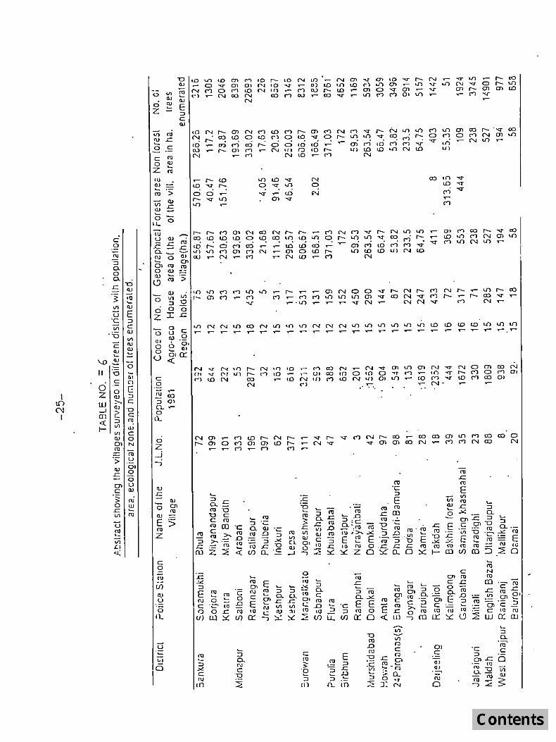
A random sampling with villages as sampling units has been adopted. A list of villages in each district is prepared from the District Census Hand Book and a pilot survey was conducted by taking one or two villages in one District. In West Bengal, 25 villages were selected for the pilot survey. A list of villages selected for the pilot survey is given at Table-5. The purpose of the pilot· survey was to determine the required number of optimum sample size.
The villages selected for pilot survey were taken up one by one for carrying out complete enumeration of all the trees of 10 cm. and above diameter at DBH(08). Each of these selected villages with its area and boundaries as per the revenue records was treated as a sampling unit.
7

After completing the pilot survey the data has been processed for calculation of sample size for the whole State by using the formula:
11 = ------...;...._-::-I (1.96)( C.v)J 2 1+-
N 10
where C.V. = Co-efficient of variation
s ==xI00=87.13
X
x = Mean of the variable tree/ha. = 23.14 s = Standard deviation of tree/ha.= 20.17 N = total number of villages in the State = 41112
For large N, the value of_l (1.96)(C.V.)J2
is insignificant and N 10
the above formula for sample size will be equal to
II = ((l96~~C.v) r
= ((L96)1~7·IJ)r
= 291
The sample size obtained for the State of West Bengal has come out to be 291 villages. ( Ref. Table No.8 ). The present report is based on the data from 25 villages of the pilot survey vvhich may throw some likely indication of the type of dominant species, categories and diameter classes. The name of the villages, area, population etc. are summarized in Table No.6.
2.3 OAT A COLLECTrON :
In each se lected village, complete enumeration of all trees having diameter 10 cm. and above has been done. Dead trees having utility less than . 70% and all trees less than 10 cms. Diameter were ignored. The enumeration of trees commenced from NE quadrant of the village and proceeded in clockwise direction. However, in South Bengal, trees down to 5 cm.dia.were
8

2) The inventory in rural areas was confined to the areas within the bounds of the villages excluding the forest areas within such village areas which are defined in the manual.
3) The following two forms have been designed for data collection:
i) District Tree form{DTF) ii) Village Tree enumeration Form(VTEF)
The DTF gives the general information of the district and the number of trees according to category of plantation/tree in the sample villages. The VTEF gives the diameter, height and clear bole length of each tree enumerated in the sample village. Trees were enumerated starting from Scm. d.b.h.(o.b.) in all the districts except the North Bengal districts where trees were enumerated from 10 cm.d.b.h.(o.b.) upwards.
2.4 CATEGORIES OF PLANTATION ITREES :
Complete enumeration of trees was carried out and recorded against the following categories as per manual:
i) Farm forestry : Trees along willI fmm bunds and in small patches down to 0.1 ha.in area.
ii) Roadside plantations: Trees planted along roads (NH, SH, village roads etc.)
iii) Village woodlot: Naturally growing trees on private/community land.
jv) Block plantations: Patches covering an area of more than 0.1 ha. and nol falling in any of the above categories.
v) Ponds: For trees planted in or around water ponds.
,
vi) Railway lines: For trees planted along the Railway sides.
vii) Canals: For trees planted along canal banks.
viii) Rest: Trees not falHng in any of the .above categories.
9

2.5 DATA PROCESSING:
The following steps were followed during data processing of non-forest areas:
i) Major species in each district were identified and the rest of the species were merged and classified as 'other species'.
ii) Village-wise stem distribution was carried out according to the species, diameter class and category of trees.
iii) All villages in the same district were clubbed together and districlwise number of stems per hectare by diameter class and category of trees were calculated.
iv) From the above table the total number of stems by district and category of trees was estimated.
v) The districts of West Bengal were classified according to agro-ecological z.ones and the stem/hectare distribution by species and agro ecological regions was also determined.
2.6 AGRO- ECOLOGICAL REGIONS OF WEST BENGAL:
West Bengal has five agro-ecological regions. Their locations and details are furnished in the Map. The agro-ecological regions are briefly described below:
Region I {Code-121: SUB HUMID EGO SYSTEM:
Eastern (Chhotanagpur) plateau and Eastern ghats,Hot Subhumid Ecoregion with Red and Lateritic soils and growth period of 150-180 to 210 days.
Region II (Code-13): SUB HUMID ECO SYSTEM:
Eastern plains, Hot Sub humid (moist) Ecoregion with alluvium derived soils and growth period between 180 and 210 days.
10

Region III (Code-15): HUMID PERHUMID ECO SYSTEM:
Bengal and Assam plains, Hot Sub humid (Moist) to Humid inclusion of (Perhumid) Ecoregion, with alluvium derived soils and growth period more than 210 days.
Region IV (Code-16): HUMID PER HUMID ECO SYSTEM:
Eastern Himalayas, Warm Perhumid Ecoregion with Brown and Red hill soils and growth period more than 210 days.
Region V (Codc-1 0): COASTAL ECO SYSTEM:
Eastern coastal plains, Hot Subhumid to Semi-arid Ecoregion, with coastnj alluvium derived soils and growlh period belween 90-210+ days.
The following table shows the distribution of geographical area of West Bengal by district and agro-ecological region.
Agro-ecological Regions (Area in sq.km.)
District Geograph ical area Code Code Code 15 Code 16 Code 18 (sq.krn) 12 13
Darjeeling 3149 - - 649 2500 -JaJeaiguri 6227 - - 5227 1000 -Coochbchar 33137 - - 3387 - -Bankur<l 6882 3750 - 3132 - -Miclnapore 1;1081 2500 - 9581 - 2000 Burclwan 7024 1750 - 5274 - -Hoogl11;{ 3149 - - 3149 - -PuruliCl 6259 6259 - - - -Birbllurn 4545 1250 - 3295 - -24 Prgs(N&S) 14136 - 11636 - 2500 Maida 3733 - 500 3233 - -Dinajpur(N&S) 5358 - 1000 4358 - -Nadia 3927 - - 3927 - -Murshidabad 5324 - - 5324 - -Howratl 1467 - - 1467 - -Calcutta 104 - - 104 - -Tolal: 88,752 15509 1500 63743 3500 4500
N. B. The above area figures are approximate and tentative.
II
CHAPTER: III
RESULTS OF THE SURVEY
3.1 TREES COMMONLY MET WITH:
Tables 1 to 3 give the details of the distribution of trees by diameter classes and by categories of species in 25 villages of West Bengal. It is noticed from the raw data that occurrence of major species varies from district to district. In Purulia, Bankura and Midnapore districts,Azadirachta indica, Acacia arabica, Terminalia arjuna, Shorea robusta, Eucalyptus hybrid, Mangifera indica, Acacia auriculiformis, Madhuca lalifolia are some of the more important species while in Darjeeling district, Albizzia species, Alnus nepalensis, Ailanthus altissima, Artocarpus & Machilus are the important tree species. In Maida district, Mangifera indica, Eucalyptus hybrid, Acacia auriculiformis, Dalbergia sissoo and Azadirachta indica are some of the main species. In Howrah district, Borassus flabellifer, Acacia arabica, Cocos nucifera, Mangifera indica, Acacia auriculiformis etc. are important. It is to be remembered that ttle results are based only on a pilot survey and are therefore bound to be tentative in nature. These, however, have indicative value.
3.2 PER HECTARE DISTRIBUTION OF TREES BY DIAMETER CLASS AND CATEGORIES OF TREES:
Table 1 shows that maximum number i.e. about 43% of trees occur in 10-20 cm. diameter class followed by about 21 % trees in 05-10 cm. diameter class, then 20% in 20-30 cm. diameter class. It may also be seen that only 6% of trees occured in 40 cm. and above diameter class.
This table also reveals that in 25 villages of West Bengal, Miscellaneous species has the largest representation i.e. 27% followed by Mangifera indica 12%, Eucalyptus species 10%, Acacia auriculiformis 10%, Acacia arabica 7% etc.
From the Table it is also found that the stem/ha. for the species combining all the categories has maximum contribution from Miscellaneous species(6.95), followed by Mangifera indica(3.08), Eucalyptus species(2.73) and Acacia auriculiformis(2.55) etc.
J2
Similarly, it is noticed that trees/ha. is maximum in the diameter class 10-20cm.(11.16), followed by 5.41 in diameter class 05-10cm. , 4.96 in diameter class 20-30 cm. etc. Only 1.62 trees per ha. exist in 40cm. and above diamoter class.
The distribution of total number of trees specieswise and categorywise (all diameter class combined) has been presented in Table 2. It is observed that when all the dia classes are combined, the representation of trees in the category "Rest" is the highest i.e. 36% followed by the category "Block Plantation"(17%),"Ponds,,(16%), " Village woodlot"(13%)etc.Farm forestry has only 4% contributiorP." This table also reveals that the stem/ha. is maximum for trees in Category "Rest"(9.04), followed by "Block Plantation"(4.37) and in "Ponds"(4.16)etc.
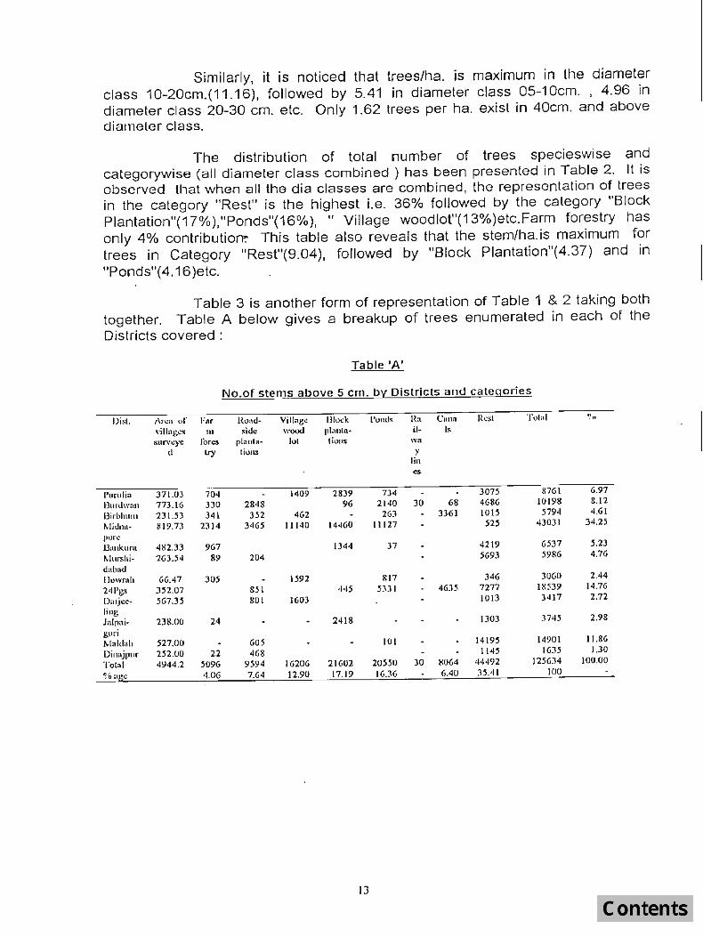
Table 3 is another form of representation of Table 1 & 2 taking both together. Table A below gives a breakup of trees enumerated in each of the Districts covered:
Table 'A'
No.of stems above 5 em. by: Districts and categories
))i,1. !\r~" "f For l{o,,<1- Vil[ng~ 1310.:1< I'Olltls Rn C" .. " Resl '1'<)1,,1 '!o
\'ill"~~~ til "icic wood pl:lllln- il- ls
suryc)'c lores plnnl,,- 101 lions wa
U try lions Y lin es
I'urulin 371.03 704 1409 2839 734 3075 l!7()1 6.97
Ourdwn .. 773.16 330 2848 96 2140 30 68 4686 10198 8.12
l3irbhllll1 231.53 341 352 462 26:1 3361 1015 5794 4.61
' .... !i,lllll. 819.73 2314 3465 11140 14460 11127 525 43031 34.25
pur..: UallkunI 482.33 967 1344 37 4219 6537 5.23
I>lurshi· 263.54 89 204 5693 5986 4.76
dabnd Howl'nh 66.47 305 1592 lel7 346 30GO 2.44
241'gs 352.07 &51 445 ~3JI 4635 7277 ISD9 14.76
D'lIj.:c· 567.35 801 1603 1013 3417 2.72
ling lnlpai- 238.00 24 2418 1303 3745 2.98
guri 1>1"1<1,,h 527.00 605 101 14195 14901 11.86
Dill;ljjJUI' 252.0U 22 468 11"'5 1635 1.30
Tolal 4944 .2 5096 9594 16206 21602 20550 30 8064 44492 125634 100.00
~·o a "~ 4.06 7.64 12.90 17.19 16.36 6.40 35.41 100
13

Table B: No.of stems/ha.above 5 cm. by Districts and Categories:
Districts Area Farm Road Viii a- B'ock Ponds Rail- Canals Rest Total
of vill- fores- side ge planta- way
ages try plant- wood lion lines
surve- atlon 101 ed
Purulia 371.03 1.90 3.80 7.65 1.96 8.29 23.61
Burdwan 773.16 0.43 3.68 0.12 2.77 0.10 6.06 13.19
Blrbhum 231.53 1/47 1.52 2.00 1.14 15.00 4.38 25.03
Midnapore 819.73 2.82 4.23 13.59 17.64 13.57 - 0.64 52.49
Bankura 482.33 2.00 2.79 0.08 8.75 13.62
Murshlda- 263.54 0.34 0.77 21.60 22.71
vad Howrah 66.47 4.59 23.95 12.29 - 5.21 46.04
24 Pgs. 352.07 - 2.42 1.26 15.14 - 13.00 20.67 52.65
Darjeeling 567.35 1.41 2.63 1.79 6.03
Jalpaigurl 238.00 0.10 10.16 - 5.47 15.73
Maldah 527.00 1.15 0.19 26.94 28.28
Dinai~ur 252.00 0.09 1.86 4.54 6.29
Total: 4944.201.03 1.94 3.28 4.37 4.16 1.60 9.00 25.41
The following observations can be tentatively drawn from the above mentioned tables:
There is a preponderance of trees on the canal banks in Birbhum district whereas in Purulia and Bankura , farm forestry and Block plantations are common. In villages covered in Midnapore, trees have been found in block plantations, pond sides and village wood lots. Dinajpur(North & South) districts have predominantly roadside avenues of plantations, whereas Jalpaiguri is characterised by more of block plantations. In 24 Parganas (North & South) districts, canal bank and pond bank trees are more common. In Howrah district, in addition to pond bank trees, some village woodlots and farm forestry plantations have been recorded. It may also seen that around 34% total enumerated trees are from Midnapore District, followed by 15% from 24 Pgs., 12% from Maida, 8% from Burdwan and 7% from Purulia.
Table B reveals that stem/ha.is maximum for Midnapore(52) and 24 Pgs. District(52) and minimum for Oarjeeling(6) and Dinajpur districts(6). A lot of variation may be seen among the figures of districtwise stem/ha. It is again repeated that the above observations are not foolproof as these are based only on limited data of pilot survey.
14

Table 5 gives the breal< up of enumerated trees in 25 villages of West Bengal by species and districts. The trees/ha. is maximum in case of the species Misc.{6.95),followed by Mangifera indica(3.08), Eucalyptus species (2.73), Acacia auriculiformis(2.55), Borassus flabellifer(1.28), Acacia arabica(1. 71) etc.
3.3 NUMBER OF TREES:
Based on the data of pilot survey of 25 villages, the stem/ha.for the whole State of West Bengal comes out as 2S.41,which comes to approximately 196 million stems for the slate of West Bengal.
3.4 TREE SPECIES FOUND IN VARIOUS AGRO- ECOLOGICAL REGIONS:
West Bengal has been divided in 5 agro-ecological regions as mentioned in para 2.6. Details of tree species occurring in different Agro ecological zones are furnished in table NO.4.
An analysis of the information available from Table No.4 would lead to the following conclusions:
1. Trees of only one village in the coastal agro-ecological zone (code no.18) was enumerated. As such it would not be proper to draw any conclusion regarding occurrence of tree spp.in the zone from the information of the last column of the table. However, within the particular village viz.Satilapur, the tree density in terms of number of stems per hectare is exceedingly high i.e. 67.13 and there is a preponderance of Cocas nucifera (coconut trees) in ttle village, as expected, followed by Mangifera indica (Mango), Ajadiracha indica (Neem) and Acacia arabica ( Babul) trees.
2. The number of stems per hectare varies considerably from one agro-ecological region to another. While this is in the region of 26 to 27 per hectare in the Bengal Assam Alluvial humid perhumid ecoregion(code no. 1 5) and in the Western lateritic sub-humid ecoreglon(code no.12). the number appears to be 20 to 21 trees/ha and the Eastern Himalayan humid perhumid ecoregion(code no.16)in the region of 8 to 9.
It may be indicated in this connection that in the hills, most of the samples of villages fell in 'forest' or 'Khasmahal' villages. Such villages have very few trees in the habitable portion while the surrounding portion have dense forests within the recorded village area. As it was impossible to enumerate all trees in the surrounding areas, only the inhabited portions of such villages were taken up for enumeration.
15
3. In the Bengal Assam Alluvial r~gion{Code No.15), a large number of spp(at least 33) have been found. The predominant ones being Tal{Barassus flabellia), Babul(Acacia arabica), Mango, Khejur(Phoenix sylveetrie), Akash-moni(Acacia auriculiformis), Coconut, Siris,Sissoo,Jeol and Eucalyptus, arranged in order of occurrence. The principal species in the lateritic South Western districts, arranged in order of occurrence in terms of number of stems per hectare, are Palas (Butea monosperma), outnumbering the other spp. by a substantial margin, followed by Sabia {Acacia arabica). Sissoo (Dalbergia sissoo), Neem (Azartichtata indica), Arjun (Terminalia arjuna), Eucalyptus hybrid, Tal (Borassus flabellifer) and Kul (Zizyphus mauritania).
4. In ecoregion 16, Cryptomeria japonica, the exotic that has almost naturalised(although without· natural regeneration) in the forests of higher elevations in Darjeeling district, appears to be equally popular in the village areas. The other prevalent species are Albizzia spp., Cassia siamea, Gmelina arborea, Ailanthus spp., Schima wallichii, Alnus nepalensis, Michelia champaca and Betula alnoides.
The predominant species of the various agro-ecological regions can thus be identified with a fair amount of accuracy from the tabulated data. The conclusions sought to be drawn may be taken as more indicative than conclusive in nature, considering the limited sample size in each agro-ecological region.
3.5 OCCURRENCE OF BAMBOO:
Bamboo in non-forest areas were enumerated along with tree species in all the villages. Occurrence of bamboo spedes varies from district to district. A picture of occurrence of various bamboo species in different districts as revealed from the pilot survey in 25 villages have been summarized below. The number of bamboo culms per ha. and the total number of bamboo culms in each district(combined for all species) are also given in the following table.
16

TABLE - 'C'
OCCURRENCE OF BAMBOO SPECIES IN VARIOUS DISTRICTS
SI.No. District Species Name Number of bamboo culms/ha.
1 Bankura Bambusa tulda 2.36 Unidentified bamboos
2 Midnapore Bambusa balcooa 12.40 Dendrocalamus strictus Miscelianeous bamboo species
3 Burdwan Bambusa tulda 4.04 Dendrocalamus strietus
4 Purulia Dendrocalamus strictus 0.71 Mise.bamboo spp.
5 Birbhum Dendrocalamus species 3.54 Dendrocalamus hamiltonii Unidentified bamboo
6 Murshidabad Bambusa balcooa 5.13 Bambusa tulda
7 Howrah Misc.bamboo species 21.85 8 24 Parganas Bambusa balcooa 4.52
(South Bambusa species and North)
9 Darjeeling Bambusa balcooa 1.29 Dendrocalamus hamillonii Unidentified bamboos
10 Jalpaiguri Bambusa nutans 8.45· Bambusa balcooa Dendrocalamus striclus Bambusa species Unidentified bamboos
11 Maida Bambusa balcooa 10.16 Unidentified bamboos
12 Dinajpur Bambusa balcooa 4.47 (North and Bambusa nutans South) Dendrocalamus strictus
17

BIBLIOGRAPHY
1. India 1993 - Published by the Director, Publication Division, Ministry of Information and Broadcasting.GovLof India.
2. Introducing West Bengal - Published by Information and Cultural· Affairs Department, GovLof West Bengal; April,1994.
3. State Report on West Bengal Forests 1993-94 Planning and Statistical Cell - Principal Chief Conservator of Forests, West Bengal.
4. District Census Handbook: All the districts of West Bengal Census of India, 1981 Series 23,West Bengal, Part XIII A, Village & Town Directory, Directorate of Census Ope ra lion, West B eng al.
5. Census of India, 1991, Final Population Totals. Series - I, Paper 1 of 1992, VaLli Registrar General and Census Commissioner,lndia.
6.. Hindustan Year Book 1971, 39th year of Issue M.C.Sarkar & Sons Private Ltd.,Calcutta-12.
7. Manual of Instructions for field inventory in Non-forest areas.- Forest Survey of India.
I~

DISTRIBUTION OF SAMPLE VILLAGES OF WEST BENGAL ACCORDING TO AGRO-ECOLOGICAL ZONE KrM 10 0
t
~-
f;C % lpo 2po ~f Kl'I'Is
I .._
.. r ~ ..... J.. - ... ,-.~
_"", .... ' ;J ~,., \ :-<-(' .".) "} ~. . . ....
. ~~t4 " . ./'. 1'::\ ~ \ • ~ ~ ~~ID PERHUM() ECOSVS!.Elot. 1.,.( __ .,--.I
~ ,J-:!!-' 8£NGAl.. a ASSAM PLAIN. IoiOT SUBHUMIO (MOIST) " ~j TO HUMID I NCLUSION OF (PCRHUMIO) .ECOREGION,
1_ (- WITH ALLUVWM DERj"i[:O SOILS a GP 210+ DAYS . . ~ \._
\ ... ....,_ : 1;'1
t' t') ·1 \' ; /,[_ I
- "\O_,"'" \. " -9 \ ' C\ I ) r \~ _~ r- '
" I (t I ""_.,, J -"\.- > -._ l \
\ ----- ... \"'...--.... I , __ "" , ..; ,
SUBHUMIO ECOSYSTEM ~ " . .. EAS f lHN (UiHOTANAGIPUR) PL 4TEAU GHATS, liOT SUBHUU ID ECOREGION.WITH RCD a lAlfRfT1 C SOI LS 8 GP 150-180( T0210)+OAY5
£,gA.1!.TA L ECOSYSTEM
EASTERN COASTAL PLAIN, HOT SUBHUtwllO TO SeWI ARIO ECORfGIOH , WITH COASTAL AL l UVIUM DERIVED SOILS a c;p '90-2100+ DAYS .
____ • £ASTt:fUI HIMALAYAS , WARM PERHUMID ECOOE"GtON WITH BROWN a HUl ... ILL SOll.S a Cp 210+ MYS.
D ISTR I CT
~=-=:':':::"-!;o.:::':;:'::=':":~';:'=""9HUM 'D (MOIST) ECOR£O10 H.WITH ~-~-----------t-----""'AlLUVIUM-OERIVED SOILS a
GP 180-210 DAYS.
z. 3.
MI ONAPUR ~ S 6 1. 8 .
8UROWAN 9 In
PURULIA II. BIIlBIIUM 12 .
13. MUNStflDABAO '4-HOWAAH IS. 24 Pt~1ANAS : .
Ie . OARJE£:LI NG 19.
20. ZI.
",ALPAIGUPII ~Z . MA LDA" " 2.3. WEST OlN4JPl~ 24.
.2.5.
HIT YAJlANOAPUR 12 MAl Tl8ANDH t2 ARA8AR I 1"5 SATfLAPUR 18 PHUk.8ARIA 12. JNDKUR. 15 L£PSA 15 JOG£SNWARDIHI 12 MAHE$H PUR .2
IKALABAHAL 12 KAMAL PUR ' Q NARAYANBATI .~ OO"~t. 15
~~OtWRr~:'",.mLA ~ DHOSA 15 KMII RA 15 TAKOANA 1& ~AI<Hl" FOREST Itt SAMSHING KHASMOHAI 16 8AflADIGHI 1& UTTAR JAOUPUR 15 NALU_PUA 15 DAMA I 15

Table 1 : Distribution of stems by Diameter class (in cm.) & Species in 25 villages of West Bengal.
All Categories combined
SI No. Name of Species
1 1
1 Acacia arabica 2 Acacia auricullitormis 3 Ailanthus altissima 4 Albizzia species 5 Alnus nepalensis 6 Artocarpus species 7 Azadirachta indica 8 Betula alnoides 9 Born bax ceiba
10 Borassus flabellifer 11 Butea monosperma 12 Cassia species 13 Casurina equisetjfolia 14 Cocos nucifera 15· Crataeva unilojcularis 16 Cryptomeria japanica 17 Dalbargia sissoo 18 Enterolonbium saman 19 Eucalyptus hybrid 20 Eucalyptus species 21 Ficus species 22 Gmelina arborea 23 Holoptalea integrifolia 24 lagerstoemea spaciosa 25 Lannea coromondalica 26 leucaena leucocephala 2 7 Lichi chinensis
28 Machilus species 29 Madhuca latifolia 30 Mangifera indica 31 Melia azadirachta 32 Michelia champaca 33 O stodes paniculata 34 Phoenix sylvestris 35 Pongomea pinnata 35 Pridian guava 37 Schima wallichii 38 Shorea robusta 39 Spondios pinnata 40 Syzygium cu mini 41 Tectona grandis 42 Terminalia arjuna 43 Zizyphus species 44 Rest of species
Grand Total . Percentage
Estimated trees/ha
Spp.
Code 05-10
2 3
5 1381 A06 9393
39 0 51 209 53 0 94 0
103 44 126 0 131 0 132 0 146 0 189 119 195 266 A10 0 246 0 256 0 268 801 329 0 346 1531 348 10573 385 3 420 16 456 0 506 0 509 0 A30 643 A14 0
559 0 561 0 569 13 583 0 595 0 652 0 676 0 701 0 A07 0 794 0 802 0 81 2 0 843 0 858 2 860 43 930 1 944 1738
10·20
5650 3073
43 2110
317 546
2247 32 25
135 3599 686 150 152
4
192 1462
95 12 47 2693
9 44 24
185 950 267
24
11 16
5442 75 69 28
365 65
139 235 114 30 97
2 381 401
2 176 5
Diameter Class ( In em)
20",)0 30-40 40-50 50~0 60·70 70'"
5 6 7 8 9 10
1168 204 29 1 0 0 123 11 0 0 0 0 46 11 4 3 "1 0
938 462 161 36 11 10 4 0 0 0 0 0
303 146 105 38 13 9 540 109 28 16 5 5 24 1 1 0 0 0 19 12 11 1 0 1
1456 3392 1232 122 8 1 569 157 20 5 0 1
36 1 0 0 0 0 7 1 0 0 0 0
4732 1572 22 1 0 0 1 0 0 0 0 0
454 223 0 0 0 0 291 60 21 6 5 0
56 41 25 3 3 1 139 6 0 0 0 217 9 0 1 1 0
9 a 4 3 5 9 44 3 0 0 0 0
5 0 0 0 0 47 4 1 0 0 0
119 30 7 0 0 0 35 3 0 0 0 0 17 1 0 1 0 0
1 0 0 0 0 0 1 1 4 10 18 22
3544 1804 1238 1198 895 1115 16 4 0 0 0 0 14 1 0 0 0 0
2 0 0 0 0 0 1685 305 0 0 0
10 8 1 0 2 16 0 0 0 0 0
127 52 26 "10 2 8 18 6 4 1 0 1 18 7 2 0 0 0 50 16 6 4 0 0
1 0 0 0 0 0 168 105 49 15 3 4 74 15 1 1 0 0
7208 2319 722 281 145 2 11
Area 4944.21 ha
Total %
11 12
8433 6 .71 12600 10.03
108 0.09 3937 3.13
321 0.26 1160 0.92 2994 2.38
58 0.05 69 0 .05
6346 5.05 4351 3.46
842 0.67 424 0.34
6479 5.16 5 0
869 0.69 2646 2 .11
224 0.18 2924 2 .33
13494 10.74 50 0 .04
107 0 .09 30 0 .02
237 0.19 1106 0. 88
948 0.75 43 0.03
12 0.01 72 0 .06
15249 12.14 95 0.08 84 0.07 30
2556 87
155 460 144
57 173
5 768 4 93
34389
0.02 2 .03 0 .07 0.12 0 .37 0.11 0 .0 5 0 .14
o 0.61 0.39
27.37
Est.
trees/hOi 13 1.71 2.55 0.02
0.8 0 .06 0.23 0.61 0.01 0.01 1.28 0.88 0.17 0 .09 1.31
o 0.18 0.54 0 .05 0 .59 2.73 0.01 0 .02 0 .01 0.05 0.22 0 .19 0.0 1
o 0.01 3.08 0.02 0.02 0.01 0.52 0.02 0.03 0 .09 0 .03 0.01 0.03
o 0,1 6
0 .1 6.95
26776 55196 2 4552 11111 3725 1759 111 5 1400 125534 100 25.41 21.31 43.93 19.54 8.84 2 .96 1.4 0. 8 9 1. 11 100
5.41 11 .16 4.96 2.25 0. 75 0.36 0 .23 0 .28 25.41
- 20-

SI No.
Table 2: Distribution 01' stems by Species & Categories In 25 villages 01 West Bengal.
All Diameter Class combined
Name 01 Species
1 1 1 Acacia arabica 2 Acacia auriculhformis 3 Ailanthus altissima 4 Albizzia species 5 Alnus nepalensis 6 Artocarpus species 7 Azadirachta indica 8 Betula alnoides 9 Bombax ceiba
10 Borassus fJabellifer 11 8utea monosperma 12 Cassia species 13 Casurina equisetifolia 14 Cocos nucifera 15 Cfataeva unilojcuraris 16 Cryptomeria japanica 17 Dalbargia sissoo 18 Enterolonbium saman 19 Eucalyptus hybrid 20 Eucalyptus species 21 Ficus species 22 Gmelina arborea 23 Holoptalea integrifolia 24 lagerstoemea spaciosa 25 lannea coromondalica 26 leucaena leucocephala 27 lichi chinensis 28 Machilus species 29 Madhuca latifolia 30 Mangifera indica 31 Melia azadirachta 32 Michelia champaca 33 Ostodes paniculata 34 Phoenix sylves tris 3S Pongomea pinnata 36 Pridian guava 37 Schima wallichii 38 Shorea robusta 39 Spondios pinnata 40 Syzygium cumini 41 Tectona grandis 42 Terminalia arjuna 43 Zizyphus species 44 Rest of species
Spp.
Code
2 5
A06 39 51 53 94
103 126 131 132 146 189 195 A1D 246 256 268 329 346 348 385 420 456 506 509 A3D A14 559 561 569 583 595 652 676 701 AD7 794 802 812 843 858
3
596 436
a 139
a 11
209 o 1
328 5 o o
137 a o
294 3
252 751
5 10 o o
74 o a o 1
88 3 o o o 4 o o o 5 o o
860 301 930 a 944 1443
II 4
898 4277
o 107
14
13 30
3 5 o
114 12
1 o
694 524
o 273
1536 o o o o o
63 o o o ·
36 4
49 o
10 o 1 a a a o o 1 o
928
Category 01 TI ccs III IV V VI VII
I> 7 8 9 546 379 101 375 307 232
1265 28 13
932
197 1488 6016 183
o 0 1611 852
o 0 1 62
93 o 1
27
710 o 2
2216 45 2 159 o 712 1 o 188 5
2023 0 3383 000
163 0 0 13 21 225
129 0 74 154 1348 . 26 282 10786 118
o 7 1 1 6 o 0 0 000
252 0 49 o 32 31 000
10 0 a 11 2 1
1130 10 1875 o 29 a
31 a 0 26 0 a o a 1106
25 a 5 o a 12
451 0 0 000 809 a 0 71 500
100 213
6955
3 95 o 11
522 7768
o 2639 o 1194 o 0
20 145 o o o o a o o o o o o o a o o a a o o o o D a a a a o o a o o o o a o o a
a a 3 a a
38 a 1
217 7 o o
1052 o
474 o o
10 o o o
715 o o o 8 o o o
142 o o o o o 6 a
a 51 a 0
10 1168
Area 4944.21 ha
VIII 10 2069
115 7
688 o
853 701
o 49
2800 4140
14 2
928 5
12 517
18 397
21 37 79 30
237 731 107 43
2 57
12102 59
4 4
1298 53
142 9
144 35 96 o
217 269
15595
Tot'll
11 8433
12600 108
3937 321
1160 2994
58 69
6346 4351
842 424
6479 5
869 2646
224 2924
13494 50
107 30
237 1106 948
43 12 72
15249 95 84 30
2556 87
155 460 144 57
173 5
768 493
34389 Grand Total 5096 9594 16206 21602 20550 30 7870 44686 125634 Pcrccn t;Jgc 4.06 7.64 12.9 17.19 16.36 0.02 6.26 35 .57 100 Estimated trces/ha 1.03 1.94 3 .28 4 .37 4.16 0.01 1.59 9.04 25.41
- 21 -
%
12 6 .71
10.03 0 .09 3.13 0 .26 0.92 2.38 0.05 0 .05 5.05 3.46 0.67 0.34 5.16
o 0.69 2.11 0.18 2.33
10.74 0.04 0.09 0.02 0 .1 9 0 .88 0.75 0 .03 0 .01 0.06
12.14 0.08 0.07 0 .02 2.03 0 .07 0 .12 0 .37 0 .11 0 .05 0.14
a 0 .61 0.39
27.37 100
Est trces/ha
13
1.71 2.55 0.02
0.8 0.06 0 .23 0.61 0.01 0.01 1.28 0.88 0 .17 0.09 1.31
o 0.18 0.54 0.05 0.59 2.73 0.01 0.02 0.01 0.05 0 22 0.19 0 .01 ;.
o 0.01 3.08 0.02
. 0 .02 0.01 0 .52 0.02 0.03 0.09 0.03 0 .01 0.03
o 0 .16
0 .1 6.95
25.41
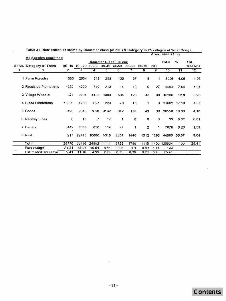
Table 3 : Distribution of stems by Diameter class (In cm.) & Category In 25 villages of West Bengal. Area 4944.21 ha
All 5[!ccies com bined Diameter Class! In em) Total % Est
51 No. Category of Trees 05-10 10 : 20 20-30 ·30-40 40-50 50-60 60-70 70 + trees/ha 1 1 2 3 4 5 6 7 B 9 10 11 12
Farm Forestry 1553 2554 518 298 130 37 5 5096 4.06 1.03
2 Roadside Plantations 4372 4209 740 213 "14 10 9 27 9594 7.64 1.94
3 Village Woodlot 371 9104 4188 1804 534 128 43 34 16206 12.9 3.28
4 Block Plantations 16396 4203 693 223 70 13 3 21602 17.19 4.37
5 Ponds 425 9043 7096 3132 642 130 43 39 20550 16.36 4.16
6 Railway Lines 0 10 7 12 1 0 0 0 30 0.02 0.01
7 Canals 3442 3633 650 114 27 1 :2 1 7870 6.26 1.59
8 Rest 217 22440 10660 5315 2307 1440 1012 1295 44686 35.57 9.04
Total 26116 5ti19G 24552 11111 3725 1759 1115 1400 125634 100 25.41 Percentage 21.31 43.93 19.54 8.84 2.96 1.4 0.89 1.11 100 Estimated Trees/ha 5.41 11.16 4.96 2.25 0.75 0.36 0.23 0.28 25.41
- 22-
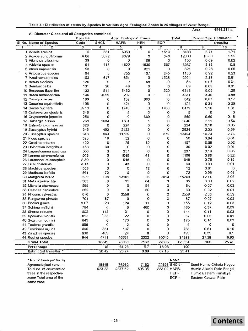
Table 4: Distribution of stems by Species In various Agro Ecological Zones In 25 villages of West Bengal.
All Diameter Class and all Categories combined Species
SI No. Name of Species
1 2 1 Acacia arabica 2 Acacia auriculliformis 3 Ailanthus altissima 4 Albizzia species 5 Alnus nepalensis 6 Artocarpus species 7 Azadirachta indica 8 Betula alnoides 9 Bombax ceiba
10 Borassus flabelliter 11 Butea monosperma 12 Cassia species 13 Casurina equtsetifolia 14 Cocos nucifera 15 Crataeva unilojcularis 16 Cryptomeria japanica 17 Dalbargia sissoo 18 Enterolonbium saman 19 Eucalyptus hybrid 20 Eucalyptus species 21 Ficus species 22 Gmelina arborea 23 Holoptalea integrifolia 24 lagerstoemea spaciosa 25 lannea coromondalica 26 leucaena leucocephala 27 Uchi chinensis 28 Machilus species 29 Madhuca latifolia 30 Mangifera indica 31 Melia azadirachta 32 Michelia champaca 33 Ostodes paniculata 34 Phoenix sylvestris 35 Pongomea pinnata 36 Pridian guava 37 Schima wallichii 38 Shorea robusta 39 Spondios pinnata 40 Syzygium cumini 41 T ectona grandis 42 Terminalia arjuna 43 Zizyphus species 44 Rest of species
Grand Total Percentage Estimated trees/ha •
• No. of trees per ha. in Agroecological zone = Total no_ of enumerated trees in the respective zonel Total area of the same zone.
Code
:3 5
AOO 39 51 53 94
103 126 131 132 146 189 195
A 10 246 256 268 329 346 348 395 420 456 506 509
A30 A 14 559 561 569 583 595 652 676 701
A07 794 802 812 843 858 860 930 944
SHCN
4
861 3872
o 118
o 5
617 o
20 544
4059 o o o o o
1084 o
492 883
18 o
30 o o o o o
72 108
o o o o
87 20 o
113 35 o o
631 469
4711
18849 15
20.42
18849 923.22
Agro Ecological Zones
HAPB HEH 5 6
6053 0 8379 3
o 108 1622 1630
o 321 753 157 851 0
a 58 49 0
5482 0 292 0 159 683 424 0
1743 0 5 a o 869
1561 224 a
2432 0 11739 0
32 a 25 82 o 0
237 0 1045 61 948 0
43 0 o 12 o 0
13101 26 31 64 o 84 o 30
2556 0 o 0
124 11 o 460
31 22
173 2
137 24
16631 76930 61.23 26.74
76930 2an.52
- 23-
o o o o o o
2502
7162 5.7
8.89
7162 805.35
ECP 7
1519 346
o 567
o 245
1526 o o
320 o o o
4736 o o o o a
872 o o o o o o o o o
2014 a o o o o o o o o o 3 o o
10545 22693 1806 67.13
Total
8 8433
12GOO 108
3937 321
1160 2994
58 69
6346 4351 842 424
6479 5
869 2646
224 2924
13494 50
107 30
237 1106
948 43 12 72
15249 95 84 30
2556 87
155 460 144
57 173
5 768 493
34389 125634
100 25.41
Note:
22693 SHCN.338.02 HAPB
HEHECP -
Area 4944.21 ha
Pcrcentage Estimated
9 6.71
10.03 0 .09 3 .13 0 .26 0.92 2.38 0.05 0.05 5.05
trces/ha
10 1.71 2.55 0.02
0.8 0.06 0.23 0.61 0.01 0.01 1.28
3.46 0.88 0.67 0.17 0.34 0.09 5.16 1.31
o 0 0.69 0.18 2.11 0.54 0.18 0.05 2.33 0.59
10.74 2.73 0.04 0 .01 0.09 0.02 0.02 0.01 0.19 0.05 0.88 0.22 0.75 0.19 0.03 0.01 0.01 0 0.06 0.01
12.14 3.08 0.08 0.02 0.07 0 .02 0 .02 0.01 2.03 0.52 0.07 0.02 0.12 0.03 0.37 0.09 0 .11 0.05 0.14
o 0.61 0 .39
27.38 100
0.03 0.01 0.03
o 0.16
0.1 6 .95
25.41
Semi Humid Chhota Nagpul Humid Alluvial Plain Bengal Humid Eastern Himalaya Eastern Coastal Plain

Table 6 : Distribulton of stems by Species & Districts In 25 villages of West Bengal.
All Diameter Classes and All Categories combined
51 No. Name of Species ... 1 Acacia arabica 2 Acacia auriculliformis 3 Ailanthus aitissima 4 Albizzia species 5 Alnus nepalensis 6 Artocarpus species 7 Azadirachta indica 8 Betula alnoides 9 Bomb::!x coiba
10 Borassus "abollifet 11 Butea menesperma 12 Cassia species 13 Casurina equisetifolia 14 Cocos nucifera 15 Crataova unilojcularis 16 Cryplomerla japanica 17 Dalbargia sissoo 16 Enterolonbium SOlman 19 Eucalyptus hybrid 20 Eucalyptus species 21 Ficus spocios 22 Gmelina arberea 23 Holoptalea inlegrifolia 24 Lagorstoomoa spadosa 25 Lannea coromondalica 26 Leucaena leucocephala 27 Uchi chinen sis . 28 Machilus species 29 Madhuca latitolia 30 Mangitera indica 31 Melia azadirachta 32 Michelia champaca 33 Os1odos paniculala 34 Phoenix sylves1ris 35 Pongomea pin nata 36 Pridian guava 37 Schima wallichil 38 ShO{ea robusta 39 Spondios pinnata 40 Syzygium cumini 41 Tectona grandis 42 Terminalia arjuna 43 Zizyphus species 44 Ros1 ot spodes
;I Grand Total Percentage
Spp. Code Ban- Midna- Burd
kura pore wan 2 3 4 5
5 144 1802 563 A06 160 5641 2211
39 0 0 0 51 0 821 366 53 a 0 0 94 0 293 0
103 166 1S36 0 126 0 0 0 131 0 0 0 132 537 767 1546 146 1337 0 0 189 0 0 159 195 0 0 0 AID 0 4744 0 246 0 0 0 256 0 0 0 268 0 0 747 329 0 0 0 346 1935 0 95 348 0 12433 0 385 0 0 0 420 0 0 0 456 30 0 0 50S 0 0 0 509 0 0 0 A30 0 0 0 A14 0 0 0 559 a 0 0 561 0 a 0 569 141 2252 440 583 0 0 0 595 0 0 0 652 0 0 a 676 0 0 0 701 0 0 0 A07 0 0 121 794 0 0 0 802 87 57 0 812 0 0 0 843 0 0 0 858 0 5 0 860 244 0 0 930 241 0 0 944 1545 12380 3810
6567 43031 10198
5.23 34.25 8.12
Name of the District
PUtU- Bir- Murshi· Howrah lIa bhum dabad 6 1 B 9
25 619 839 267 2563 1494 10 14 . 0 0 0 0
0 189 54 0 • 0 0' 0 0
0 0 401 0 459 135 0 0
0 0 0 0 20 0 0 0
0 143 155 1120 3014 0 0 0
0 0 0 0 0 0 0 0 0 0 0 148 0 0 0 0 0 0 0 0 0 1224 0 0 0 0 0 224 0 709 6 0
660 0 0 0 0 31 0 0 0 25 D 0 0 0 0 0 0 0 0 0 0 25 609 407 0 0 61 0 0 0 43 0 0 0 a 0
72 0 0 0 0 0 665 155 0 0 0 a 0 0 0 0 0 0 0 0 0 0 0 0
87 0 0 0 0 0 0 0 0 0 0 0 0 0 0 0 0 57 0 0 0 0 21 0 0 0 0 0
463 0 0 0 252 0 0 0
1146 943 3121 705
8761 5794 5966 3060 6.97 4.61 4.76 2.44
- 24-
Ar ea 4944.2 1 ha
24 Darjee. Jalpal Maldah West Total Pgs ling gurl Oinajpur 10 11 12 13 3921 0 0 0 13 6433
0 0 3 270 234 12600 0 108 0 0 0 108
857 36 1592 0 0 3937 0 321 0 0 0 321 0 79 78 0 309 1160 0 a 0 398 0 2994 0 56 0 0 0 58 0 0 0 0 49 69
1760 0 0 216 0 6346 0 0 0 0 0 4351 0 0 683 0 0 842
424 0 0 0 0 424 1587 0 0 0 0 5479
5 0 0 0 0 5 0 869 0 0 0 669 0 0 1 372 302 2546 0 0 0 0 0 224 9 0 0 170 0 2924
401 0 0 0 0 13494 0 0 0 0 19 50 0 0 82 0 0 107 0 0 0 0 0 30 0 0 0 237 0 237 0 0 61 4 0 1106
887 0 0 a 0 948 0 0 0 0 0 43 0 12 0 0 0 12 0 0 0 0 0 72
968 0 26 10452 149 15249 0 0 64 0 31 95
.,,0 84 0 0 0 84 0 30 0 0 0 30
2556 0 0 0 0 2556 0 0 0 0 0 87
0 0 11 0 23 155 0 460 0 0 0 460
0 0 0 0 0 144
0 0 0 0 0 57 137 0 0 0 15 173
0 0 0 0 0 5
61 0 0 0 0 768 0 0 0 0 0 493
4966 1358 1144 2780 491 34389
18539 3417 3745 14901 1635 125634
14.76 2.72 2.96 11.86 1.3 100
%
6.71 10.03 0.09 3.13 0.26 0.92 2.38 0.05 0.05 5.05 3 .46 0.67 0.34 5.16
0 0.69 2.11 0.18 2.33
10.14 0.04 0.09 0.02 0.19 0.88 0.75 0.03 0.01 O.OS
12.14 0.08 0.07 0.02 2.03 0.07 0.12 0.37 0.11 0.05 0.14
0 0.61 0.39
27.38 100
Est. treeslha
1.71 2.55 0.02 0.8
0.06 0.23 0.61 0.Q1 0.01 1.28 0.88 0.17 0.09 1.31
0 0.18 0.54 0.05 0.59 2.73 0.Q1 0.02 0.01 0.05 0.22 0.19 0 .0 1
0 0.Q1 3.08 0.02 0.02 0.01 0.52 0 .02 0.03 0.09 0.03 0.01 0.03
0 0.16
0.1 6.95
25.41
I to N
I
c o nJ
S 0. o 0.
,C~ ·~ Vl
Ii ·C Vi
''6 C ClJ '-
,e '-QJ
E :J c: QJ
III ru ClJ
\.OClJ o
II
d z w _l
al <{ I-
c 'Q' ()
o G IV :J ::--..C QI '0
2: c OJ ::J
Vl til v, C CU 0 0' N nJ
.s: (l)
,C
CTI C .~
o .c III
U C'O ._ Vi ,(,1
~
nJ U
0) o o U QJ
ru ill '-nJ
"0 Q.J
o VI ~ OJ Q.J
o ~ E z ::J C QJ
Vl l1l fU,C '-o .S c ro o III
Z ~ (II OJ '-ro >
-o
nJ
E-QI Ql ro
o o. o o <J
8 c II.) .2
c .2
e ~I 01 (X «
III 00 ::J 0) CI.. o ll..
o Z _j ,
o QJ
E5 ro Z
c o ell
(J) OJ U
o (L
<0 oJ'> .0 en M Cl 'V 0' 0'
I"'IMOMlO (" N CO N
N
.0 r- 10 N.O l'.I Ol 'Z' Ol ,0 'V r- N '<r lJ') .- r- CO N .0 'V ..- 0) 1O ,n to rl V1 01 V) 'l' oJ'> N "<J' Cl r-- V') N 'n M CO r- to ..- en 0 "<T 0'1 ..- "<J' en r- 0'1 en I.D
CO M OJ CO'V"- V) n ("') 0' U") ..- M "<I' ,.....
(0 N r-- 0'1 N ("") I.D ("") r-- cn n N M 'q' r- N v) U") C"'l V') en CO r-''q' CO N r- cO 1O a (0 ('"1 0 (0 -q 0 r-- If) V) "<T cO M r- 0 C"l 0 M N 0'1 U") 10 0') n CO r- a 0 (0 (0"'- 0> M <0 C"'l M 'V 'V.n N V) r-CO r- 0' C"'1 N HI r.:> (0 r- V) <0 1O V') N 1O U) N C"'1 N ,0 C"'1 N
1- r--co~ .0 r-</) V1 CO ,.....
.") 01 1"'1 CO 1"'1 I.DtOCl~ex:) O("'}co..-n 01 C"'l N N y- M ~
N a N
r- C"'1I"'1MVr-to V) 0 r- U") V) ~ lO CO 01 M 10 OlOr- V)WID ID M N
N ex:)
M U)
V) ...- 0' ("') co r-- ~ <0 r--~lDv)MNO'lv) .... "<J'Ml()NU")..-to
r--y-..-cnNOO"<J'r-Nr--MNr-~U")r-OO M..-nnV)V')V)O'I"<J'CON .... Mr--.-r-ro"<J'..-
.-.V')..-..-..- .... N NN'V n 1"'1..-
'"" ...;r N "n r-- N ,n <0 .- n <0 N N.... O'J V) 0'1 N 'V Nom co N ..- UI co I() a (0 0 "'T M .n "<T 1- MOM 01 (II "<1' ('I Ul r- ,,,,) ,0
f"l ID N co co N Ii) M l.O N 1.1) 01 U") ..- (0 C"l "<J' \0 n co 0) r) ..- ....- N - ..-N
Ncn...-n<or--Nrr--Oloncncnwr-
C'O :;J .c ru
.c ~ :;J
E nJ C Q
(J)
I'll ._
M M M
'- ('(J ::J 'C o.cu ro.!:l .- ::l ro .c (f)Q.,
'C'O 0>
r= C'O '2 nJ o .... 0 c: .-=- '0 .0 E o .c ro ee U)~(J)O::
.__ ::J 0.. C\J C :g 2
.;:: ::J ~
"0 ·c
ro III Cl OJ
_..J
:2 TI .__ ro ... > .c III Q.J
01 o ...,
c: 10 ;:
'0 .__ :J
,I)
. '.
.... r- "<J' M N r-- co ..- ex:) ro m l() M co to 0 N'V -q-cncnCON C"}f"lNCO N
C1l ·c ::J
E '- . ni co ro 5.~'__.D .cOO ..c co :J; C ~.;:: Vj D _e.·.ro ro '::; .oro nJ' ciJ (lJ ro ell;>-' x ... .._ C :;J E ~ E .~ ::J'~ E III .c (0 C\I O . .c .c .c ro :!~~ZO~Q.,O::'::::
.__ I'll
::J -E a.. ::J ro ~ ro 0. oX .D ._ 'c E E (0 ::J ::J ro 0 E U)i.l:(J)OCO«
E :J
:;J .c -e in ::J
0...
"0 ro .0 ro "0 :;:: t:? ::J
-<;'; .... _
.__ ro 0'1 c ro .c. W
.._ ro .._ 0'15, 10 ._
C ::J >-''o ro ,CO
.c ro
"0 oX ro I-
c: Ol nJ C .c
"0 0 C1l 0...0
CTI E ::J C _ '-III 1U 10
O::~(j
0) C
0) 0'
C\l o
.._ ::J 0.
'co c: o

Table No.7 Botanical name and Local name of the species used in the report.
Spp. SI.No. Name ot the species Code Local Name
1 2 3 4 .1 Acacia arabica 5 Bable, Babul 2 Acacia auriculiformis A06 Akasmani 3 Ailanthus excelsa 40 Gokul 4 Albizzia species 51 Siris 5 Alnus nepalensis 53 Ulis 6 Artocarpus species 94 Kathal 7 Azadirachta indica 103 Neem 8 Betula alnoides 126 9 Bombax ceiba 131 Sumul 10 Borassus flabellifer 132 Tal 11 Butea monosperma 146 Palash 12 Cassia species 189 Minjri, Sonari, Amaltha 13 Casurina equisetifolia 195 Jhau 14 CDGOS nucifera Al0 Narkel Narial 15 Crataeva unilojoulars 246 Barun 16 Cryptomeria japanica 256 Dhupi 17 Dalbargia sissoo 268 Sisoo 18 Enterolonbium saman 329 Raintree 19 Eucalyptus hybrid 346 Eucalyptus, Nilgri 20 Eucalyptus species 348 Eucalyptus, Nilgri 21 Ficus species 385 Dumur, 8at, Aswatha 22 Gmelina arborea 420 Gamar 23 Holoptalea integrifolia 456 Salla 24 Lagerstoemea spaciosa 506 Jarul, Ajhar 25 lannea coromondalica 509 Jia, Doka 26 Leucaenaleucocephata A30 Subabul 27 Lichi chinensis A14 Lichu, Lichi 28 Machilus species 559 Kawala 29 Madhuca latitolia 561 Mahua 30 Mangifera indica 569 Am 31 Melia azadirachla 583 Ghora Neem 32 Machelia champaca 595 Champ 33 Ostodes paniculata 652 8epad 44 Phoenix sylvestris 676 Khajur 35 Pongomea pinnata 701 Karanj 36 Psydium guava AD7 Piara, Amruth 37 Schima wallichii 794 Chalauni 38 Shorea (Obusta 802 Salla 39 Spondios pinnata 812 Amra 40 Syzygium cumini 843 Jam, Jamun 41 Tectona grandis 856 Segun. Sagwan 42 Terminalia arjuna 860 Arjun 43 Zizyphus species 930 KUL, Ber 44 Rest of species 944 Others
- 26 -

Table No.8 Data used for sample size determination
District Village Non·forest area Trees above Stem/ha.(auove ( ha.)
Bankura Nityanandapur 117.20 Maity Bandh Bhula
Oarjeeling Takdah Samsing Khasmahal Bakhim forest
Howrah Khajurdaha Mursh ada bad Domkal 24 Prgs.(South) Kamra
Dosa Phulbaria Bamunia
MaIda Uttar Jadupur D.Dinajpur Damai U.Dinajpur Mallikpur Ja/paiguri Baradighi Midnapur Satilapur
Phulbaria Araban Lepsa I ndkuri
Birbhum Kamalpur Burdwan Jageswardih
Maheshpur Purulin KhulLlunhnl Birbhum Narayanbali
NO. of sample villages n = 2S
78.87 266.26 403.00 109.00
55.35 66.47
263.54 64.75
233.50 53.82
527.00 58.00
194.00 238.00 338.02 17.63
193.69 250.03 20.36
172.00 606.67 166.49 371.03 59.53
4944.21
LX = 578.73
X = 23.1492
. LX2 _ (I:XY S2 = 11
Jl
L: X 2 = 23572.14 = 407.00
s = 20.17
s C.V.= = x 100= 67.13
X
27
10 em. dia. 10 em.dia.) 1305 11.13 2046 25.94 1728 6.04 1442 3.58 1924 17.65
51 0 .92 ~054 45.94 5917 22.45 5157 79.64 6835 29.27 3448 64.06
14901 28.27 658 11 .34
977 5.04 3745 15.73 21577 63.83 226 12.82
2657 13.71 2403 9.61 840 41.25
3607 20.97 5783 9.53 1886 11.32 5905 15.01 761 12.78
98833 578.73
NO. of villages to be surveyed
{(l96)(87.13)}2 = = 291.64
10

0::::
~ "E :£ .c: II> ~ II)
~ c::: ""8 Q)
0 C 0:::: I!! Q) ::::; "U 5: '" 0 en c: >-u. Q) II> 1 .!11. E "U ICl .:.c "U ...
"0 :g .l!! " c c n:I :> ..Q 0 -(0 ... II U. 0:: al D- o:: 0 0:: • II II IJ • D II •
u) UJ t2 0 C) c(
~ 0 >
ClO CD N c(
::I: -UJ :!: UJ I-UJ u.. 0 0 Z
"VH/SW3.LS
Ui 011
Ui Z c Iii 0::: 011 ~
a: ~ " Z lC ~ :r: z ~ ~ Z <I: 0::: Z ::::l in ::::; C <I: 1= :r: => <I:
~ ::!:
" :r: w ::::l I el ~ ~ Q.. 0::: <I: ::::l C( LLI n... <I: 0::: ::::l 0::: ::::l ::::;
(.) CI) ~ " <t: :r: ..., ..., C <t: (.) :,:: z :><: ::::l c Q. 0 0:: ~ -' 0::: C n... -' 0 Z 0::: 0::: m
....I 0 <t: z <I: ::::l <I: ..t <I: 0 0 0 e( ::::l ::::l 0::: <I: ~ ..., (.) 0 15 ::!: ::!: z N (.) :r: :r: al n. lC in
C D • [J IJ C IJ C • a c D • • ... • (/) I- (i) 0 011
i2 z ~~ c
l- e(
(/) ~r-- CD <I: is ..., Q~ <I:
>- Z <I: :r:r--15 9* CI)
ID 0::: (i) « ~l() ::::l 0::: ::iE 011 W e( z a: :r: U; « iii * ~~
I- ~"'t" ~C") (/) 0 el-
m W 0 0::: a: <I: N (.) Q. ~ 0 <t lL. a: ::::l~ :z ::::l
~o Q~ 0 ;:teo :r: ~ Z ~* ....I lL. <I: :'::('1 0 ...,
::!: 0 W ::::l :r:
~ C) ai~ c( 0:: ,,~ I- iii g"'t" Z W :r: 0 a: w A.
<I: <I: ::::; 0:::
~~ ::::l~
::::l ~r--n. <I:
al