Embed Size (px)
Citation preview

REPORT ON THE
INDUCED POLARIZATION
AND RESISTIVITY SURVEY
VIMY CLAIMS #lo0 & 200
NICOLA MINING DIVISION, B. C.
921/7W so- %a' d 120- 5 I fb.i FOR
LAWRENCE MINING CORPORATION LTD.

TABLE OF CONTENTS
Part A :
Part B:
1.
2.
3 .
4.
5.
6.
7.
8.
9 .
10.
Part C:
Notes on Theory and field procedure
Report
Introduction
Description of Claims
Presentation of Results
Geologic Description of Rocks and Mineralization
Discussion of Results
Summary and Conclusions
Assessment Details
Statement of Cost
Certificate - A. W. Mullan Figure # 2
Illustrations
Plan Map (in pocket)
IP Data Plots
8 pages
I.P.P. 4057
NOS. IP 5165 - 1, 2, 3
Date: Oct. 5 , 1 9 7 9

PHOEN I X GEOPHYSICS LIMITED
NOTES O N T H E T H E O R Y , M E T H O D OF FIELD O P E R A T I O N ,
A N D PRESENTATION OF D A T A
FOR T H E I N D U C E D P O L A R I Z A T I O N M E T H O D
Induced P o l a r i z a t i o n as a geophys ica l measurement r e f e r s
t o t h e b locking a c t i o n o r p o l a r i z a t i o n of m e t a l l i c o r e l e c t r o n i c
conductors i n a medium of i o n i c s o l u t i o n conduct ion.
T h i s e l ec t ro -chemica l phenomenon occurs wherever
e l e c t r i c a l c u r r e n t i s passed through an a r e a which c o n t a i n s m e t a l l i c
minerals such as b a s e metal s u l p h i d e s . Normally, when c u r r e n t i s
passed through t h e ground, as i n r e s i s t i v i t y measurements, a l l of t h e
conduction t a k e s p l a c e through i o n s p r e s e n t i n t h e water conten t of t h e
rock, o r s o i l , i . e . by i o n i c conduct ion . Th i s i s because almost a l l
minera ls have a much h i g h e r s p e c i f i c r e s i s t i v i t y than ground wa te r ,
The group of m i n e r a l s commonly d e s c r i b e d a s "metal l ic" , however,
have s p e c i f i c r e s i s t i v i t i e s much lower than ground waters .
induced p o l a r i z a t i o n e f f e c t t a k e s p l a c e a t those i n t e r f a c e s where t h e
mode of conduct ion changes from i o n i c i n t h e s o l u t i o n s f i l l i n g t h e
i n t e r s t i c e s of t h e rock t o e l e c t r o n i c i n t h e m e t a l l i c mine ra l s p re sen t
The
- 2 -
i n t h e rock.
The b lock ing a c t i o n o r induced p o l a r i z a t i o n mentioned
above, which depends upon the chemical e n e r g i e s necessa ry t o a l low
t h e i o n s t o g i v e up o r r e c e i v e e l e c t r o n s from t h e m e t a l l i c s u r f a c e ,
i n c r e a s e s w i t h t h e t i m e t h a t a d . c . c u r r e n t i s allowed to f low through
t h e rock; i . e . as i o n s p i l e up a g a i n s t t h e m e t a l l i c i n t e r f a c e t h e
r e s i s t a n c e to c u r r e n t f low i n c r e a s e s . Eventua l ly , t h e r e i s enough
p o l a r i z a t i o n i n t h e form of excess i o n s a t t h e i n t e r f a c e s , t o apprec i ab ly
reduce t h e amount of c u r r e n t f low through t h e m e t a l l i c p a r t i c l e . This
p o l a r i z a t i o n t a k e s p l a c e a t each of t h e i n f i n i t e number of so lu t ion-meta l
i n t e r f a c e s i n a mine ra l i zed rock.
When t h e d . c . v o l t a g e used t o c r e a t e t h i s d .c . c u r r e n t
flow is c u t o f f , t h e Coulomb f o r c e s between t h e charged i o n s forming
t h e p o l a r i z a t i o n cause them t o r e t u r n t o t h e i r normal p o s i t i o n . Th i s
movement of cha rge c r e a t e s a sma l l c u r r e n t f low which can be
measured on t h e s u r f a c e of t h e ground as a decaying p o t e n t i a l d i f f e r e n c e .
From a n a l t e r n a t e viewpoint i t can h e seen t h a t i f t h e
d i r e c t i o n of t h e c u r r e n t through t h e system is reve r sed r epea ted ly
be fo re t h e p o l a r i z a t i o n occur s , t h e e f f e c t i v e r e s i s t i v i t y of t h e system
a s a whole w i l l change as t h e frequency of t h e swi t ch ing i s changed.
T h i s is a consequence of t h e f a c t t h a t t h e amount of c u r r e n t Bowing
through each m e t a l l i c i n t e r f a c e depends upon t h e l e n g t h of time t h a t
c u r r e n t has been pass ing through it i n one d i r e c t i o n .
.
- 3 -
The v a l u e s of t h e pe r cent f requency e f f e c t o r F.E. are
a measurement of t h e p o l a r i z a t i o n i n t h e rock mass.
t h e measurement of t h e degree of p o l a r i z a t i o n i s r e l a t e d t o t h e apparent
r e s i s t i v i t y of t h e r o c k mass i t i s found t h a t t h e meta l f a c t o r va lues o r
M.F. are t h e most u s e f u l v a l u e s i n de te rmining t h e amount o f
p o l a r i z a t i o n p r e s e n t i n t h e rock mass.
normalizing t h e F.E. v a l u e s f o r va ry ing r e s i s t i v i t i e s .
However, s i n c e
The MF v a l u e s are obta ined by
The induced p o l a r i z a t i o n measurement i s perhaps t h e most
powerful geophys ica l method f o r t h e d i r e c t d e t e c t i o n of meta l l ic
su lph ide m i n e r a l i z a t i o n , even when t h i s m i n e r a l i z a t i o n i s of ve ry
low concen t r a t ion . The lower l i m i t of volume pe r cent su lph ide
necessary t o produce a r ecogn izab le I P anomaly w i l l vary w i t h t h e
geometry and g e o l o g i c environment of t h e sou rce , and t h e method of
execut ing t h e survey . However, su lph ide m i n e r a l i z a t i o n of less than
one pe r c e n t by volume h a s been d e t e c t e d by t h e I P method under
proper g e o l o g i c a l c o n d i t i o n s .
The g r e a t e s t a p p l i c a t i o n of t h e I P method h a s been i n t h e
search f o r d i s semina ted m e t a l l i c su lph ides of less t h a n 20% by volume.
However, it has a l s o been used s u c c e s s f u l l y i n t h e sea rch f o r massive
su lph ides i n s i t u a t i o n s where, due t o sou rce geometry, depth of source ,
o r low r e s i s t i v i t y of s u r f a c e l a y e r , t h e EM method cannot be s u c c e s s f u l l y
app l i ed . The a b i l i t y t o d i f f e r e n t i a t e i o n i c conductors , such as water
f i l l e d s h e a r zones , makes t h e I P method a u s e f u l t o o l i n checking EM

- 4 -
anomalies which a r e suspec ted of be ing due t o t h e s e causes .
I n normal f i e l d a p p l i c a t i o n s t h e IP method does not
d i f f e r e n t i a t e between the economical ly impor t an t m e t a l l i c mine ra l s
such a s c h a l c o p y r i t e , c h a l c o c i t e , molybdeni te , g a l e n a , e t c . , and t h e
o t h e r m e t a l l i c mine ra l s such as p y r i t e .
i s d u e t o t h e t o t a l of a l l e l e c t r o n i c conduct ing m i n e r a l s i n t h e rock mass.
Other e l e c t r o n i c conduct ing m a t e r i a l s which can produce a n I P response
a r e magne t i t e , p y r o l u s i t e , g r a p h i t e , and some forms of hemat i te .
The induced p o l a r i z a t i o n e f f e c t
I n t h e f i e l d procedure , measurements on t h e s u r f a c e are
made i n a way t h a t a l lows t h e e f f e c t s of l a te ra l changes i n t h e p r o p e r t i e s
of t h e ground t o b e s e p a r a t e d from t h e e f f e c t s of v e r t i c a l changes i n t h e
p r o p e r t i e s . Current is a p p l i e d to t h e ground a t two p o i n t s i n d i s t a n c e
(X) a p a r t . The p o t e n t i a l s are measured a t two p o i n t s (X) f e e t
a p a r t , i n l i n e w i t h t h e c u r r e n t e l e c t r o d e s i s a n i n t e g e r number (n) times
t h e b a s i c d i s t a n c e (X).
The measurements are made a long a surveyed l i n e , w i th
a c o n s t a n t d i s t a n c e (nX) betwen t h e n e a r e s t c u r r e n t and p o t e n t i a l
e l e c t r o d e s . I n most surveys , s e v e r a l t r a v e r s e s are made wi th v a r i o u s
v a l u e s of (n) ; i . e . (n) = 1 , 2 , 3 , 4 , etc. The k ind of survey r equ i r ed
( d e t a i l e d o r reconnaissance) d e c i d e s t h e number of v a l u e s of (n) used.
I n p l o t t i n g t h e r e s u l t s , the v a l u e s o f apparent r e s i s t i v i t y ,
apparent p e r cent f requency e f f e c t , and t h e appa ren t metal f a c t o r
i
- 5 -
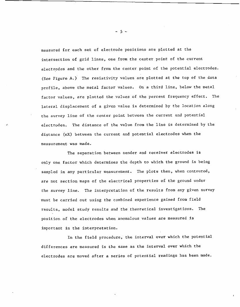
measured f o r each set of e l e c t r o d e p o s i t i o n s a r e p l o t t e d a t t h e
i n t e r s e c t i o n of g r i d l i n e s , one from t h e c e n t e r p o i n t of t h e c u r r e n t
e l e c t r o d e s and t h e o t h e r from t h e c e n t e r p o i n t of t h e p o t e n t i a l e l ec t rodes .
(See F igu re A . )
p r o f i l e , above t h e me ta l f a c t o r va lues .
f a c t o r v a l u e s , are p l o t t e d t h e v a l u e s of t h e pe rcen t f requency e f f e c t .
l a t e r a l d i sp l acemen t o f a given v a l u e i s determined by t h e l o c a t i o n along
t h e survey l i n e of t h e c e n t e r p o i n t between t h e c u r r e n t and p o t e n t i a l
e l e c t r o d e s . The d i s t a n c e of t h e v a l u e from t h e l i n e i s determined by t h e
d i s t a n c e (nX) between t h e c u r r e n t and p o t e n t i a l e l e c t r o d e s when t h e
measurement w a s made.
The r e s i s t i v i t y v a l u e s are p l o t t e d a t t h e t o p of t h e da t a
On a t h i r d l i n e , below t h e metal
The
The s e p a r a t i o n between sender and r e c e i v e r e l e c t r o d e s i s
only one f a c t o r which determines t h e depth t o which t h e ground i s being
sampled i n any p a r t i c u l a r measurement. The p l o t s t h e n , when contoured,
a r e not s e c t i o n maps of t h e e l e c t r i c a l p r o p e r t i e s of t h e ground under
t h e su rvey l i n e .
m u s t be c a r r i e d o u t u s ing t h e combined expe r i ence gained from f i e l d
r e s u l t s , model s t u d y r e s u l t s and t h e t h e o r e t i c a l i n v e s t i g a t i o n s .
p o s i t i o n of t h e e l e c t r o d e s when anomalous v a l u e s are measured i s
important i n the i n t e r p r e t a t i o n .
The i n t e r p r e t a t i o n of t h e r e s u l t s from any given survey
The
I n t h e f i e l d procedure , t h e i n t e r v a l o v e r which t h e p o t e n t i a l
d i f f e r e n c e s are measured i s t h e same as t h e i n t e r v a l ove r which t h e
e l e c t r o d e s are moved a f t e r a series of p o t e n t i a l r ead ings has been made.

- 6 -
One of t h e advantages of t h e induced p o l a r i z a t i o n method i s t h a t t h e
same equipment can be used f o r b o t h d e t a i l e d and reconnaissance surveys
merely by changing the d i s t a n c e (X) o v e r which t h e e l e c t r o d e s a r e moved
each time.
t o 2000 f e e t f o r ( X ) . In each c a s e , t h e d e c i s i o n as t o t h e d i s t a n c e (X)
and t h e v a l u e s of (n) t o b e used i s l a r g e l y determined by t h e expected
s i z e of t h e mine ra l d e p o s i t be ing sought , t h e s i z e of t h e expected anomaly
and t h e speed w i t h which i t i s d e s i r e d t o p rogres s .
I n t h e p a s t , i n t e r v a l s have been used ranging from 25 feet
The diagram i n F igu re A demonst ra tes t h e method used
i n p l o t t i n g the r e s u l t s .
metal f a c t o r , and apparent pe r c e n t f requency e f f e c t i s p l o t t e d and
i d e n t i f i e d by t h e p o s i t i o n of t h e f o u r e l e c t r o d e s when t h e measurement
was made. It can be seen t h a t t h e v a l u e s measured f o r t h e l a r g e r v a l u e s
of (n) a r e p l o t t e d f a r t h e r from t h e l i n e i n d i c a t i n g t h a t t h e t h i c k n e s s of
t h e l a y e r of t h e e a r t h t h a t is be ing t e s t e d i s g r e a t e r than f o r t h e sma l l e r
va lues of (n) ; i .e. t h e dep th of t h e measurement i s inc reased .
Each v a l u e o f t h e appa ren t r e s i s t i v i t y , apparent
The I P measurement i s b a s i c a l l y ob ta ined by measuring t h e
d i f f e r e n c e i n p o t e n t i a l o r v o l t a g e (AV)ob ta ined a t two o p e r a t i n g
f requencies .
and the apparent r e s i s t i v i t y of t h e ground.
where t h e c u r r e n t i s ve ry low due t o poor e l e c t r o d e c o n t a c t , o r t h e
apparent r e s i s t i v i t y i s v e r y low, o r a combination of t h e two e f f e c t s ; t h e
va lue of ( A V ) t h e change i n p o t e n t i a l w i l l b e too small to be measurable.
The symbol "TL" on t h e d a t a p l o t s i n d i c a t e s t h i s s i t u a t i o n .
The v o l t a g e i s t h e product of t h e c u r r e n t through t h e ground
There fo re i n f i e l d s i t u a t i o n s

- 7 -
I n some s i t u a t i o n s s p u r i o u s n o i s e , e i t h e r man made o r n a t u r a l ,
w i l l r e n d e r i t imposs ib le t o o b t a i n a r ead ing .
d a t a p l o t s i n d i c a t e s a s t a t i o n a t which i t i s t o o no i sy t o record a reading.
I f a r e a d i n g can b e ob ta ined , b u t f o r r easons of n o i s e t h e r e i s some doubt
a s t o i t s accuracy , t h e r ead ing i s b racke ted i n t h e d a t a p l o t ( ).
The symbol "N" on t h e
In c e r t a i n s i t u a t i o n s n e g a t i v e v a l u e s of Apparent Frequency
E f f e c t are recorded . This may b e due to the geo log ic environment o r
s p u r i o u s e l e c t r i c a l e f f e c t s . The a c t u a l n e g a t i v e frequency e f f e c t va lue
recorded is i n d i c a t e d on t h e d a t a p l o t , however, t h e symbol "NEG" i s
i n d i c a t e d f o r t h e corresponding v a l u e of Apparent Metal Fac tor . I n
contour ing n e g a t i v e v a l u e s t h e con tour l i n e s are i n d i c a t e d t o t h e n e a r e s t
p o s i t i v e v a l u e i n t h e immediate v i c i n i t y of t h e n e g a t i v e value.
The symbol "NR" i n d i c a t e s t h a t f o r some reason t h e opera tor
a t t e m p t t o record a r ead ing a l though normal survey procedures d i d no t
would sugges t t h a t one was r e q u i r e d . T h i s may b e due t o i n a c c e s s i b l e
topography or o t h e r s i m i l a r r easons .
d i scussed above i s unique t o a p a r t i c u l a r s i t u a t i o n and i s descr ibed wi th in
t h e body of t h e r e p o r t .
Any symbol o t h e r than those
, ./. .* PHOENIX GEOPHYSICS LIMITED.

,
METHOD U S E D IN PLOTTING DIPOLE- DIPOLE
INDUCED P O L A R I Z A T I O N AND R E S I S T I V I T Y R E S U L T S
I t 9 . A 7 8 9 4 5 6 I 2 3
~ t o t l o n s on line x = E l e c t r o d e spread length n = E l e c t r o d e s e p o r o t l o n
1 t 9 I
n - 1 1,2-3,4 2,3-4,5 3.4 P P P P P n - 2 1,2-4,5 2.3-5,6 3,4-6.7 41~5-7~8 5,6-8,9 Appor e-nt R e s i s t i v i t y
P i P P P
P P n - 3 1,2-5,6 23-687 3.4-788 P 43-889
n - 4 1,2-6.7 2.3-718 3,4-8,9
4 t 9 I
n - 1 1,2- 3,4 2,3-4,5 3,4-5,6 43-67 5,6-7,8 6 8 7 - 8 ~ 9
n - 2 1.2-4.5 2.3 0 5,6 3e4-6.7 4,5-7~8 5 ~ 6 - 8#9
n - 3 1,2-5,6 23-6,7 3,4-7,8 4,5-8,9 Apparent Percent
F. E. F a E. F. E- F-E. F. E.
F. E. - F. € F. E, F. E.
F. E, F. E. Frequency Ef fect F. E, n - 4 ID2-6,7 2.3-788 3 , 4 - 8 D 9
F i g . A --. -
REPORT ON THE
I N D U C E D POLAR1 ZAT I ON
AND RESISTIVITY SURVEY
V I M Y CLAINS #lo0 & 200
NICOLA M I i J I N G D I V I S I O N , B . C .
9 2 1 / 715 FOR
LAVJRENCE M I N I N G CORPORATION LTD.
1. I N T R O D U C T I O N
An Induced. P o l a r i z a t i o n and R e s i s t i v i t y survey has been c a r r i e d
o u t on t h e Vimy Claims f o r Lawrence Mininq Corpora t ion Ltd. . The
Claims are l o c a t e d 2 6 k m . n o r t h of Merritt i n t h e Nicola Mining
Div i s ion , B . C . . The c e n t e r of t h e p rope r ty is p o s i t i o n e d a t about
50' 2 0 ' n o r t h l a t i t u d e and 120' 5 1 ' w e s t l ong i tude .
Good road access i s a v a i l a b l e from Lower Nicola on Highway # 8 ,
no r th on t h e Craigmont Mines road. The road which con t inues on t o
Chataway Lake b i s e c t s t h e p rope r ty .
The o b j e c t of t h e survey was t o i n v e s t i g a t e t h e claims a t depth
i n t h e v i c i n i t y of known mineral occur rences . This w a s achieved by
c a r r y i n g o u t t h e I P survey wi th 2 0 0 meter e l e c t r o d e i n t e r v a l s and t h e
expanding e l e c t r o d e technique t o f o u r s e p a r a t i o n s .
The survey was c a r r i e d i n e a r l y August, 1 9 7 9 under t h e d i r e c t i o n
of C r e w Leader Maurice Pa ren t . H i s c e r t i f i c a t e of q u a l i f i c a t i o n i s appended t o t h i s r e p o r t .
A Phoenix Geophys ics I P V-2 Phase domain I P system w a s used f o r
t h e survey. The I P e f f e c t was measured a s m i l l i - r ad ians of phase
s h i f t o p e r a t i n g a t 0 . 3 1 h e r t z .

- 2 -
2 . DESCRIPTION O F CLAIMS
The VIMY p rope r ty c o n s i s t s of t h e fo l lowin9 two mining c la ims:
VIMY #lo0 - 6 u n i t s , Record N o . 503 ( 8 )
V I N Y # Z O O - 6 u n i t s , Record No. 538 ( 3 )
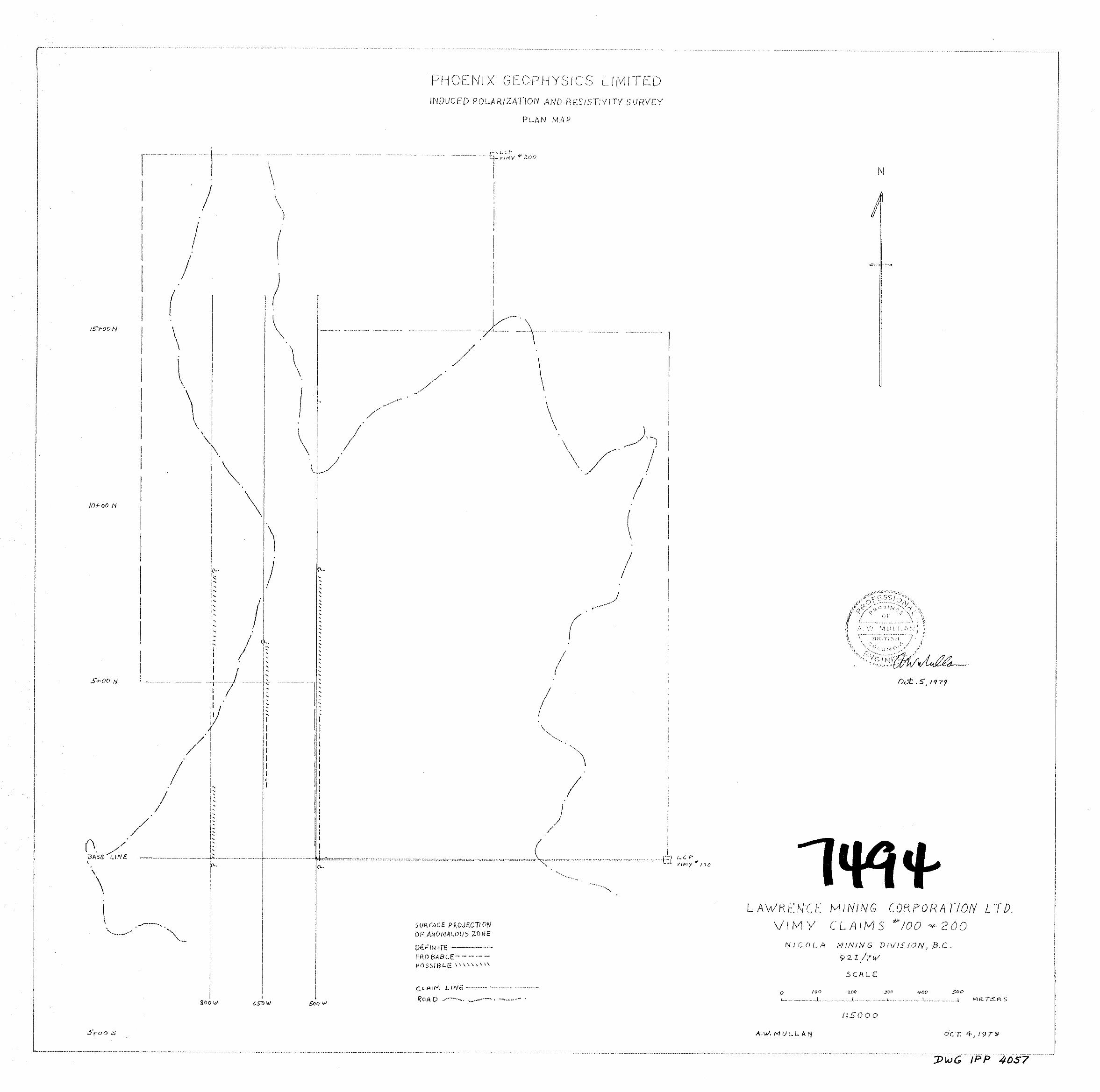
3. PRESENTATIOV O F RESULTS
The Insuced P o l a r i z a t i o n and R e s i s t i v i t y r e s u l t s a r e shown on
t h e fol lowing enclosed d a t a p l o t s . The r e s u l t s are p l o t t e d i n t h e
manner desc r ibed i n t h e no te s preceding t h i s r e p o r t .
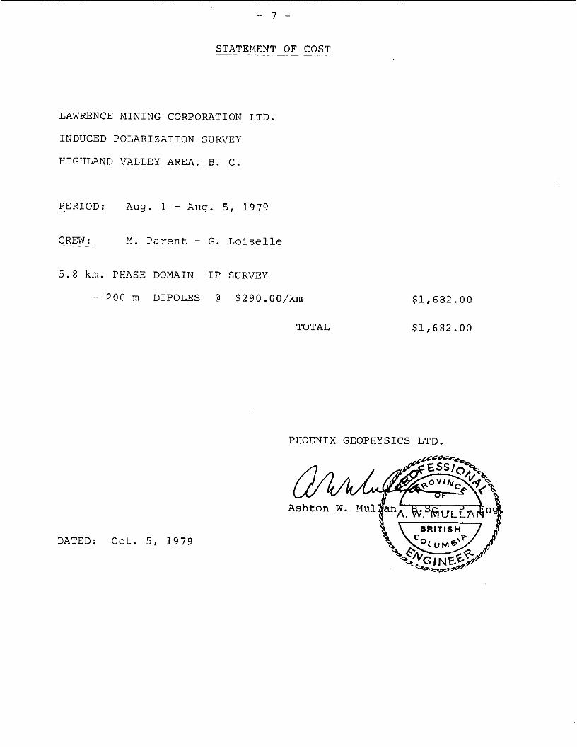
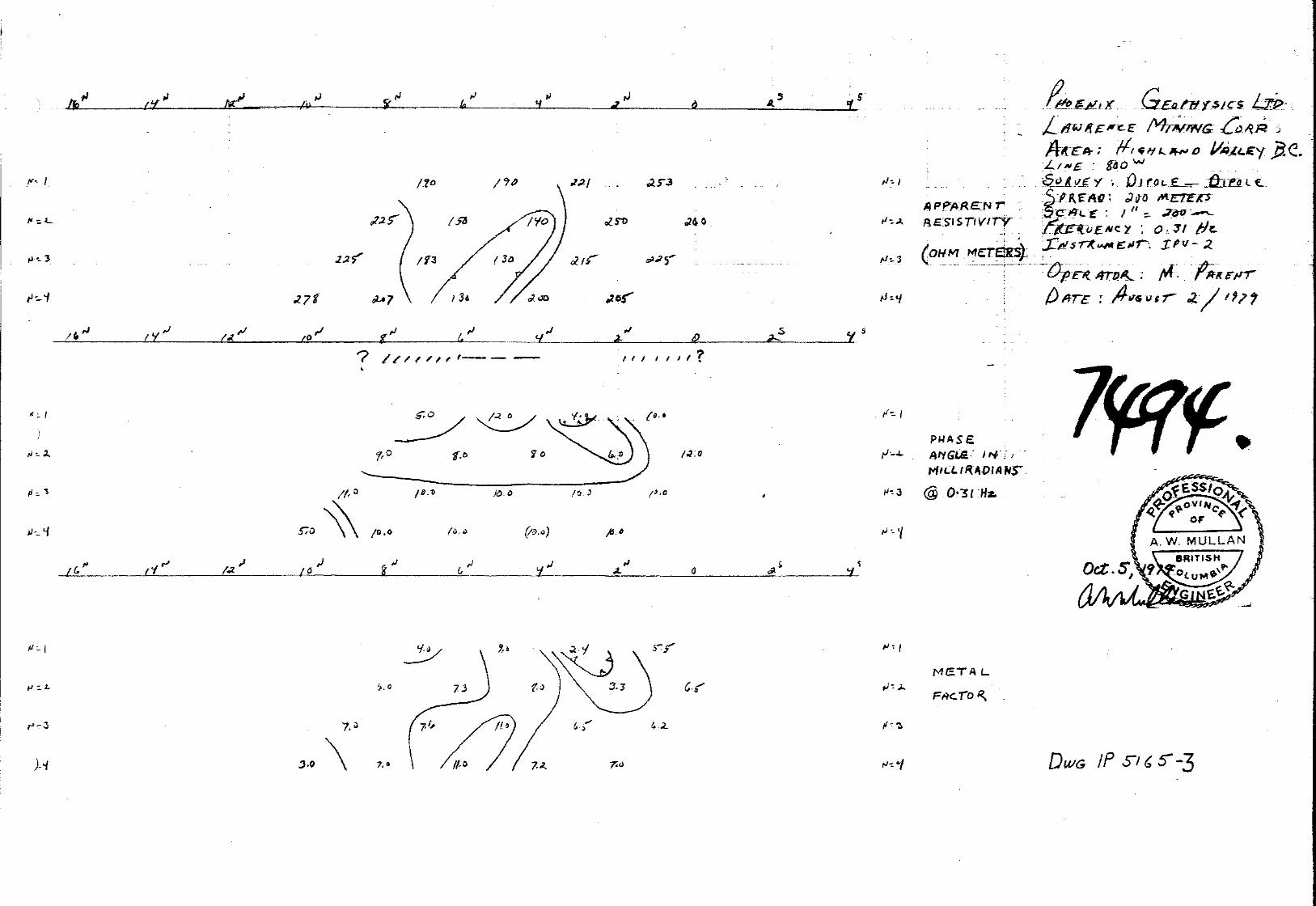
LINE NO. ELECTRODE INTERVAL DRAWING NO.
5 0 0 W 2 0 0 METERS I P 5165 - 1
6 5 0 bl 2 0 0 METERS I P 5165 - 2
800 W 200 METERS I P 5165 - 3
Also enc losed w i t h t h i s r e p o r t i s Dwg. I . P . P . 4 0 5 7 , a p l a n map
of t h e V I M Y Claims Grid a t a s c a l e of 1 : 5 0 0 0 . The d e f i n i t e ,
p robable and p o s s i b l e Induced P o l a r i z a t i o n anomalies are i n d i c a t e d
by b a r s , i n t h e manner shown on t h e legend, on t h i s p l a n map a s w e l l a s on t h e d a t a p l o t s . These b a r s r e p r e s e n t t h e s u r f a c e p r o j e c t i o n
of t h e anomalous zones a s i n t e r p r e t e d from t h e l o c a t i o n of t h e
t r a n s m i t t e r and r e c e i v e r e l e c t r o d e s when t h e anomalous va lues were measured.
S ince t h e Induced P o l a r i z a t i o n measurement i s e s s e n t i a l l y an
averaging p r o c e s s , a s are a l l p o t e n t i a l methods, it i s f r e q u e n t l y d i f f i c u l t t o e x a c t l y p inpo in t t h e source of an anomaly. C e r t a i n l y ,
no anomaly can be l o c a t e d wi th more accuracy than t h e e l e c t r o d e
i n t e r v a l l e n g t h ; i . e . when using 200 m e l e c t r o ? e i n t e r v a l s t h e
p o s i t i o n of a narrow su lphide body c a n only b e determined t o l i e
between two s t a t i o n s 2 0 0 m a p a r t . I n o r d e r t o d e f i n i t e l y l o c a t e ,
and f u l l y e v a l u a t e , a narrow, sha l low source it i s necessary t o u s e
- 3 -
s h o r t e r e l e c t r o d e i n t e r v a l s . I n o r d e r t o l o c a t e sou rces a t some depth , l a r g e r e l e c t r o d e i n t e r v a l s must be used, wi th a corresponding
i n c r e a s e i n t h e u n c e r t a i n t i e s of l o c a t i o n . Therefore , wh i l e t h e
c e n t r e of t h e i n d i c a t e d anomaly probably corresponds f a i r l y w e l l w i t h sou rce , t h e l eng th of t h e i n d i c a t e d anomaly a long t h e l i n e should
not be t a k e n t o r e p r e s e n t t h e e x a c t edges of t h e anomalous m a t e r i a l . The Claims and Grid informat ion shown on Dwg. I . P . P . 4 0 5 7 has
been taken from maps made a v a i l a b l e by t h e s t a f f of Lawrence Mining Corporat ion L td . .
4 . DESCRIPTION O F GEOLOGY
The g e n e r a l v i c i n i t y of t h e Vimy Claims i s be l i eved t o be
unde r l a in by t h e Dot q u a r t z monzonite phase of t h e Guichon C r e e k
b a t h o l i t h . The Dot phase i s a p p a r e n t l y c l o s e l y r e l a t e d t o t h e
Chataway v a r i e t y of t h e i n t r u s i v e .
A zone of f r a c t u r i n g and a l t e r a t i o n s t r ikes j u s t w e s t of n o r t h through t h e q u a r t z monzonite. Copper m i n e r a l i z a t i o n i n t h e
form of f r a c t u r e f i l l i n g s , ve ins and d i s semina t ions occurs w i t h i n
t h i s zone.
5. D I S C U S S I O N O F RESULTS
Induced P o l a r i z a t i o n surveys have p rev ious ly covered t h e a r e a
occupied by t h e Vimy Claims. The p r e s e n t survey was designed t o
look deeper than previous I P work by u t i l i z i n g r e l a t i v e l y l a r g e 2 0 0
meter e l e c t r o d e i n t e r v a l s and reading t o f o u r "N" s e p a r a t i o n s .
A survey c a r r i e d o u t by Bralorne Pioneer Mines i n 1 9 6 6 used t h e 3
e l e c t r o d e method wi th an "A" spac ing of 200 f t . . This survey would
have explored less than ha l f t h e depth of t h e f i r s t " N " s e p a r a t i o n
of t h e c u r r e n t survey .
Three reconnaissance I P l i n e s were run a long t h e w e s t s i d e of

- 4 -
t h e Vimy C l a i m s us ing t h e d i p o l e - d i p o l e e l e c t r o d e c o n f i g u r a t i o n , 2 0 0 meter e l e c t r o d e i n t e r v a l s , and reading t o f o u r " N " s e p a r a t i o n s .
R e s i s t i v i t y l e v e l s w e r e most ly i n t h e 130 t o 250 ohm meter range,
t y p i c a l of much of t h e Highland Val ley . Somewhat lower r e s i s t i v i t i e s
were encountered a t t h e s o u t h e a s t end of l i n e 500 IY.. They may
i n d i c a t e a rock type change o r a f a u l t zone.
Very weak anomalous I P e f f e c t s w e r e recorded on a l l t h r e e l i n e s .
The survey r e s u l t s f o r each l i n e a r e d i scussed below.
LINE 500 W, DWG I P 5165 - 1
Very weak I P e f f e c t s showing some depth t o t h e source were l o c a t e d between 0 + 0 0 and 8 N and appear t o ex tend beyond t h e I P
coverage i n bo th d i r e c t i o n s . The anomaly i s b e s t de f ined from 4 N sou th t o 0 + 0 0 where it
extends south of t h e survey coverage. The depth i s e s t ima ted a t
25 - 50 meters. North o f 4 N t h e anomaly appears t o deepen and t h e I P e f f e c t s
a r e weaker.
LINE 650 W , DWG I P 5165 - 2
Weak I P e f f e c t s t h a t a r e sha l low r e l a t i v e t o t h e 200 m e t e r e l e c t r o d e i n t e r v a l w e r e d e t e c t e d between 2 N and 4 N . The anomaly
probably extends t o t h e n o r t h a t depth and extends beyond t h e I P
coverage.
LINE 800 W, DWG I P 5165 - 3
A weak sha l low I P anomaly w a s l o c a t e d between 4 N and 6 N. St ronge r phase a n g l e s on t h e 3rd and 4 th s e p a r a t i o n s sugges t t h a t
t h e anomalous I P e f f e c t s may ex tend a t depth under t h e e n t i r e l i n e .

- 5 -
6. SUMMARY AND CONCLUSIONS
An Induced Polarization and Resistivity survey hsa been com- pleted on the west side of the Vimy Claims. The survey was carried out near several known copper showings including the Vimy and the Aberdeen. The purpose of the current IP survey was to explore at depth for evidence of widespread disseminated mineralization.
Very weak IP anomalies were obtained on all three lines. The anomalies, while weak, are not dissimilar to those previously recorded over knowndeposits in the Highland Valley.
The incomplete anomaly at the south end of line 500 W shows the best definition and warrants further investigation. It would be desireable to investigate a possible eastward extension of this anomaly by surveying one or two adjacent lines to the east. The anomaly could be investigated by drilling a vertical drill hole at 100 meters north on line 500 W to a depth of 200 meters. Such a hole would investigate both the phase angle anomaly and the deep lower resistivities.

- 6 -
ASSESSMENT D E T A I L S
PROPERTY: VIMY C l a i m s # l o o & 200
SPONSOR: L a w r e n c e Mining C o r p . L t d .
LOCATION: H i g h l a n d V a l l e y
TYPE O F SURVEY: Induced P o l a r i z a t i o n and R e s i s t i v i t y
OPERATING MAN DAYS: 6
EQUIVALENT 8 HR. DAYS: 9
CONSULTING MAN DAYS: 2
DRAFTING .MAN DAYS: 2
TOTAL MAN DAYS : 1 9
CONSULTLVTS :
M I N I N G D I V I S I O N : N i c o l a
PROVINCE: B r i t i s h C o l u m b i a
DATE STARTED: A u g . 1, 1 9 7 9
DATE F I N I S H E D : A u g . 5 , 1 9 7 9
NUMBER O F S T A T I O N S : 2 9
NUMBER O F READINGS: 1 5 9
KM O F L I N E SURVEYED: 5 . 8
A s h t o n W . Mul l an , 1 4 4 0 Sandhurs t P l . , West V a n c o u v e r , B . C .
F I E L D T E C H N I C I A N S :
Maurice P a r e n t , 2 2 2 S t . John S t . , S t . Leonard, N. B.
Georges L o i s e l l e , 9 C h a d b o u r n e A v e . , N o r a n d a , Q u e .
DRAUGHTSMEN :
R. C . Nor r i s , 7 0 8 - 5 1 P a r k w o o d s V i l l a g e D r . , D o n Mills, O n t .
P H O E N I X G E O P H Y S I C S LTD.
DATED: O c t . 5 , 1 9 7 9
- 7 -
STATEMENT OF COST
LAWRENCE M I N I N G CORPORATION LTD.
INDUCED P O L A R I Z A T I O N SURVEY
HIGHLAND VALLEY AREA, B. C.
P E R I O D : Aug. 1 - A u g . 5 , 1 9 7 9
CREW : M . P a r e n t - G. L o i s e l l e
5 . 8 km. PHASE DOMAIN I P SURVEY
- 2 0 0 rn D I P O L E S @ $ 2 9 0 . 0 0 / k m
TOTAL
$1,682.00
$ 1 , 6 8 2 . 0 0
PHOENIX G E O P H Y S I C S LTD.
DATED: O c t . 5 , 1 9 7 9

- 8 -
CERTIFICATE
I, Ashton W. Mullan, of the City of Vancouver, in the Province of British Columbia, hereby certify:
1. That I am a geologist/geophysicist and a fellow of the Association of Canada, Geophysics Division, with a business address at 310 - 8 8 5 Dunsmuir Street, Vancouver, B.C.
2. That I am registered as a member of the Associaiton of Professional Engineers of the Provinces of Ontario and British Columbia.
3. That I hold a B.Sc. degree,from McGill University
4. That I have been practising my profession as a geologist/ geophysicist for over twenty-five years.
5. I have no direct or indirect interest, nor do I expect to receive any interest directly or indirectly, in the property or securities of Lawrence Mining Corp. Ltd., or any affiliate.
6. The statements made in this report are based on a study of published geological literature and unpublished private reports.
7. Permission is granted to use in whole or in part for assessment and qualification requirements but not for advertising.
Dated at Vancouver
This 5th day of October, 1979

. .
..
.^....... . -
. -
1 3 1
' / I - -
/J= I

, . . . - . j
. .. 4 . . . 1 " .
" _ _ . . -. .. . - . I , . . _ . , . . . . 1 . . .
. ,
I . . . . . . , ; . .
P . . . .
. . .- ~ " . . . - .w . . . ~ . .
4 es.
rJ 'y
7
7.0
DOMINION OF CANADA: 1
1 In the PROVINCE OF BRITISH COLUMBIA.
I 1 To WIT:
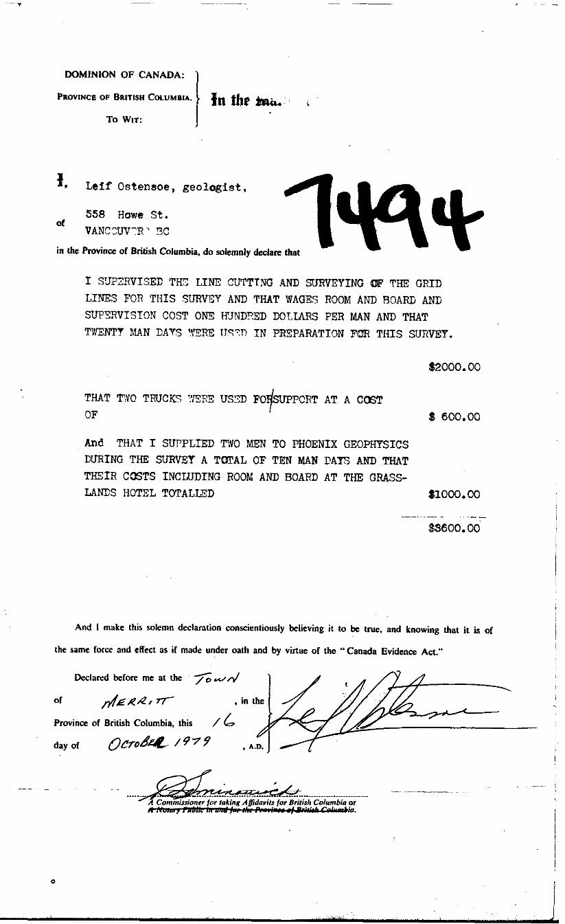
31, Leif Ostensoe, geologist,
558 Hawe St, V A N C X J T R ' !3C
of
in the Province of British Columbia, do solemnly declare that
I STV?3IIVISEC T E LINE CUTTTNG AND SURVEYING (IF THE GRID LINES FOR THIS S7VRVEY AND THAT WAGES ROOM AND ROARE ANG SUP3:RVISTCIN COST O N 3 ICJNDRZD DOLLARS PER MAN AND THAT T%W"Y XAN CAYS 93RE I J T V IN PREPARATION FQR THIS SURVEY.
$2000.00
THAT TYO TRUCKS YBRE USTD OF
AT A C06T
And THAT I SUPPLIED T#O MEN TO PHOENIX GEOPHYSICS DU'RING THE', SURVEY A TmAL OF TEN MAN PAYS AND THAT TmIR CCISTS INCLUDING ROOM AND BOARD AT THE GRASS- LANDS HOTEL TOTALLED
$ 600.00
$IOOOe 00
$SSOOe 00
And I make this solemn declaration conscientiously believing i t to be true, and knowing that it is of
the same forcc elid effect as if made under oath and by virtue of the "Canada Evidence Act."
Declared before me at the s r ~ d of &R.4/ 7 r , in the
Province of British Columbia, this /
/ 6 . day of Q C ~ O ~ * /979 , A.D.
0