Embed Size (px)
Citation preview
REPORT NO: 28 TH March 2011
REPORT ON
THE NH-57 AND RAILWAY BRIDGE OVERTHE KOSI RIVER AT NIRMALI
Prepared by
MB VERMAFormer Distinguished Scientist DRDO
Program Director TEJAS LCADirector ADA Bangalore
Email: [email protected]
COORDINATED BY
MGVP
Mithila Gram Vikas ParishadLaxmisagar, South of Nanak Gas Godown,
Darbhanga – 846009, Bihar.Email: [email protected] [email protected]
Phone/m: 9955344811, 06272-258085
PREFACE
The National Highway Authority of India has undertaken the construction of a bridge over
the River Kosi on the NH-57 at Nirmali. The NH-57 connects Muzaffarpur to Forbesganj via
Darbhanga and Jhanjharpur and is part of the East-West corridor. It passes through the
flood plains of the river Kosi through a length of approximately 11km cutting across the
Western and Eastern Embankments, at village Bhutaha and Bhaptiyahi respectively. The
Indian Railways are also constructing one parallel Bridge over the River Kosi, 60 m
downstream of the NH-57 Bridge, connecting Nirmali to Bhaptiyahi railway station.
The Bridge site selection, alignment, Hydraulic Design of waterway and River
Appurtenances like the common Guide bunds, afflux cum protection embankments,
physical model tests and computer model studies were done by CWPRS, Pune under the
guidance of a Technical Committee under the Chairmanship of DG (RD & AS), Ministry of
Road Transport and Highways/ Member (Technical), NHAI New Delhi. The Govt. of Bihar
was represented in this Committee by Chief Engineer, Central Design Organization,
Water Resources Department. Based on the tests and the studies conducted by CWPRS
the waterway for both the Bridges were fixed as 1853 m and spread of Backwater and
level of afflux upstream were estimated as 8 km and 1.35 m respectively at the Design
Discharge of 22 375 cumecs (7.9 lac cusecs). However after completion of the Guide
Bunds and Afflux cum Protection Embankments in the Kosi Flood Plains, and at about
twenty percent of the Design Discharge of the River Kosi in the monsoon floods of the
year 2010, the spread of the Backwater and Level of the Afflux far exceeded the
predictions made by the CWPRS. This resulted in inundation of large number of villages
upstream of the Bridge, affecting lives of nearly fifty thousand people. The eastern Afflux
cum Protection Embankment, Guide Bunds and the NH-57 Bridge approach segment
suffered breaches.
- I -
- iii -
A Team of Engineers, as mentioned below went through CWPRS Reports, The
Expert Committee Report and Minutes of Meetings of the Technical Committee
on the NH-57 and Railway Bridge, and basic Design Assumptions made for the
site selection and determination of the waterway, model preparation and
testing.
This Team also went through Gokhul Prasad Expert Committee
Recommendations on the NH-57and Railway Bridge over the River Kosi. They
analyzed and deliberated upon the technical issues involved in the construction
of the river training appurtenance. Some of the Team Members visited the
Bridge Site, the affected villages and met the displaced persons taking shelter
on the Kosi Eastern Embankment and spurs during the monsoon. They also
visited the Bridge site and some of the villages in the month of November 2010,
made observations of the damages and post flood Conditions of the river, both
upstream and downstream of the bridge under construction.
This study revealed that in the estimation of the Design Discharge for 100- year
Return Interval period for modeling of the bridge waterway as well as for
selection of the site, there have been certain omissions and errors in of factual
data. This resulted in the underestimation of the back water effect and the
upstream river stage, causing breaches of the River Appurtenances, shoal
formation, changes in downstream channels, sand deposition in arable land,
and erosion of villages. Therefore there was a need for a Technical Audit and
reappraisal of assumptions made in hydraulic and structural design of the
Bridge and River appurtenances. This is urgently needed for ensuring the
structural integrity of marginal embankments and for mitigating the sufferings
of the people affected by the River Backwater and high Afflux between two
embankments.
The under mentioned Engineers met at Patna on 28/3/2011 and deliberated on the above points.
1. Er Kuver Nath LalFormer Engineer in Chief, Water Resources Deptt. Govt of Bihar
- iv -
2. Er Shanti Nath Jha - v -Former Engineer in Chief, Water Resources Deptt. Bihar
3. Er. L K DasEx- Prof (SE). WALMI, Patna.
4. Er Chandra Shekhar SinghEx- SE, Water Resources Deptt. Govt of Bihar
5. Er Arun PrasadEx-SE, Water Resources Deptt. Govt of Bihar
6. Er M.G. KauleshnamEx- Chief Eng, Water Resources Deptt. Govt of Bihar
7. Er BS VermaEx- Chief Eng, Water Resources Deptt. Govt of Bihar
8. Er SS SinghEx- Chief Eng, Water Resources Deptt. Govt of Bihar
9. Er. Jay Prakash NarayanEx-S.E. Water Resources Deptt. Govt of Bihar
10. MB VermaFormer distinguished Scientist, DRDO, Progm Director LCA
The Committee of Engineers mentioned above made the following recommendations:
1. The river training work in the Kosi should be undertaken where the
channels bifurcate and should be joined there to flow as one channel.
2. The channels which have been plugged by construction of guide bunds and
bridge approach roads should also be provided with bridge.
3. The main (unified) channel of Kosi should be regularly maintained so as to
alleviate the sufferings of the people living between embankments of the
river.
4. The villages affected by afflux should be protected so as to prevent the
displacement of people. Provision should made for funding for this work by
the Ministry of Railways and Road Transport.
The Committee considered the above as issues of Highest Public Interest and
commended action by the concerned authorities of the Government of Bihar
and Central Government.
-iii-
- v -
THE NH-57 AND RAILWAY BRIDGE OVERTHE RIVER KOSI AT NIRMALI
SYNOPSIS
The human intervention in the flood plains of the River Kosi downstream of the Bhimnagar-Hanumannagar Barrage by way of construction of the NH-57 and Railway Bridges, guide bunds and river training appurtenances like afflux and protection embankments, have initiated morph dynamic changes in the river behavior. In the process of construction of high afflux bunds cum protection embankments of the NH-57, four of the five channels were closed. As a consequence, the river channel courses were altered, affecting over fifty villages in Supaul district of Bihar. Some of these villages were affected by the afflux of back water of the bridge. With the rising stage of the river, the erosion of the homestead land and structures started, forcing eviction of the people even at modest river discharge of 4265 cumecs (150 600 cusec). The backwater spread as far as 15 km upstream of the Bridge in the village Siyani. The effect of Backwater and afflux would spread further when the flow reached the design discharge of 22 375 cumecs (7.9 lacs cusec), for the NH-57 and Railway Bridges. In the estimation of the Design Discharge for 100- year Return Interval period for modeling of the bridge waterway as well as for selection of the site, there have been certain errors of factual data. This resulted in the underestimation of the back water effect and the upstream river stage, causing breaches of the River Appurtenances, shoal formation, sand deposition in arable land, changes in downstream channels and erosion of villages. This warrants a review of technical assumptions and hydraulic and structural design of the Bridge.
1. INTRODUCTION
1.1 After completion of the ‘Flood Control’ element of the Kosi project work around
1964, nearly 380 villages, with total population of nearly 9.88 lacs (2001 census),
spread over the districts of Supaul, Madhubani, Darbhanga and Saharsa were
entrapped between the two embankments of the Kosi (Ref.1). It was envisaged at the
planning stage that eastern and western embankments downstream of the barrage
would be constructed maintaining certain minimum distance between them, so as to
achieve channel flow stabilization and provide adequate flood plain area for the
- vi -
monsoons months. In some places embankments were kept as far apart as 15 Km
(e.g. Supaul-Nirmali). Approximately 1.1 lacs hectares of land lies between these flood
protections embankments. This land got permanently converted as flood plains of the
Kosi. Over years sparse human habitation and seasonal agricultural work continued in
the Kosi flood plains. Of late state sponsored major structural interventions have been
made in flood plain of the river Kosi, of course all in the name of development, which
altered the fluvial characteristics of the river, with wider ramifications on the physical
and economic survival of the inhabitants between the two embankments. The
construction of the bridge over the Kosi on National Highway-57(NH-57) is burning
examples of the same. The river Kosi is jacketed to flow between two embankments,
spaced approximately 11 km apart near Bhaptiyahi (located on the eastern
embankment in Supaul district).
2. BRIDGE SITE2.1 The bridge construction site lies between Km 37 and 38 downstream of the
Bhimnagar Barrage. The NH-57 between Muzaffarpur and Forbesganj cuts across
the river Kosi flood plain between its kilometer posts 155 to 165 near Bhutaha north of
Nirmali. The NH-57 Bridge Head lies 525meter south of the river cross section 37 in
the west, and 665 meter south of the river cross section 38 in the east, near
Bhaptiyahi. The NH-57 then runs north along the Eastern Embankment for nearly
10km before turning east for Forbesganj. The Railway Bridge runs parallel to NH-57
Bridge, 60 meter down stream, at the same site.
3. WATERWAY AND RIVER APPURTENANCES
3.1 The Planners of the NH-57 and the Indian Railways have decided to provide only
1853 meters of the waterways for their respective bridges in the Kosi flood plain, with
common guide bandhs, afflux and protection embankments. The total length of these
additional river training structures in the river flood plain is approximately 10.1 Km and
10.5 Km on the left and right side respectively. The afflux cum protection
embankments on both eastern and western ends of the bridge cut across two
channels each in the flood plain of the river, stopping their flow and consequently
increasing pressure on the main embankments.
4. PHYSICAL AND COMPUTER MODEL TESTS BY CWPRS, PUNE
4.1 The physical model testing and mathematical model studies of the bridge were
conducted at the Central Water & Power Research Station (CWPRS), Pune. The
waterways, common guide bund (i.e. inlet bund) for the bridge, afflux bunds and
approach embankments across the river have been designed for discharge of 22 375
cumecs (7. 9 lac cusec) corresponding to 100 year return period, although the
recorded less- than- 50 year peak annual discharge of the river was 25 856 cumecs (9
12 994 cusec) in the year 1968.
5. FLUVIAL BEHAVIOUR OF THE RIVER KOSI
5.1 With river discharge of 22 375 Cumec (7.9 lacs cusec), the model tests indicated
an upstream afflux of 1.35 meter up to 8 km. But the ground reality was far-off this
- vii -
prediction. At the river discharge of 1 50 600 Cusec (4265 cumecs), recorded on the
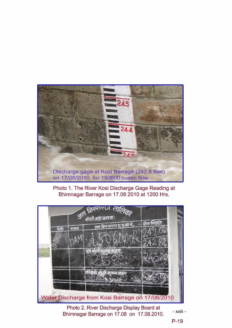
17th August 2010 at 12:00 Hrs at the Kosi Barrage at Bhimnagar (photo 1&2), the
afflux was over 3m and back water spread far upstream (photos 3&4).This caused
heavy flooding of human habitations, deposition of sand in arable lands, and
destruction of private and public properties (Photo 5, 6).Over thirty school buildings
were rendered dysfunctional. The afflux bund cum protection embankment of the NH-
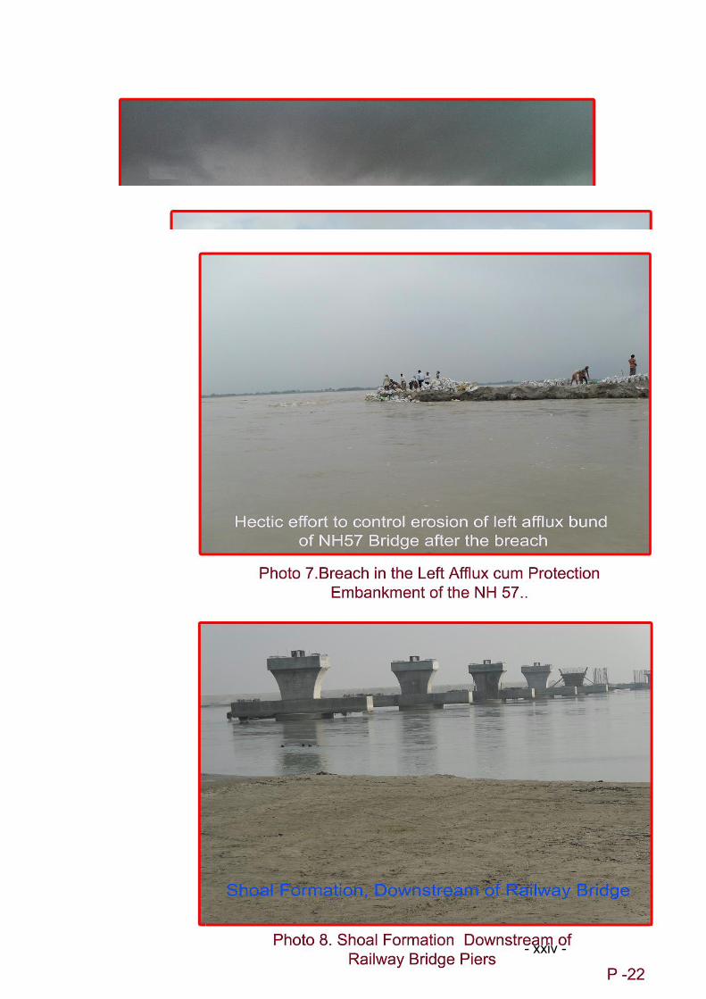
57 on the left, which had blocked the flow of two secondary channels, breached
downstream of Bhaptiyahi and was washed away in to the swirling current (Photo 7).
This breach was enlarged to a length of nearly three kilometers. All attempts to plug
this breach and stop the erosion were in vain till the end of monsoon. As a
consequence of the breach of the afflux cum protection embankment, nearly four Km
long eastern segment of the approach road of the NH 57 Bridge also got washed off
into the River Kosi. This segment of the NH-57, constructed in the flood plains of the
Kosi, had been washed away in the last monsoon too. Even after drainage of flood
water downstream through this breach, the water level rose more than three meters
high in the villages, which were located 15Km upstream of the bridge. One such
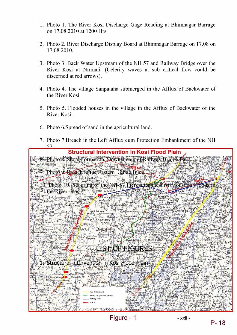
example is the village Siani, 15 km away from the Bridge (Fig1). Here the rising
backwater compelled inhabitants to leave their houses, carrying their thatched roofs
on boats. The afflux level of upstream water, caused after construction of the afflux
cum protection bunds on either side of the main channel was four to five times higher
than the estimates made by the experts. As a result of this, water had entered the
dwellings of the people, forcing their mass migration to higher places.
5.2 The residents of some of the villages between two embankments, taking shelter on
the spurs, narrated that they didn’t have to vacate their dwellings even in the 1968
floods, the year with the highest recorded flood discharge of 25 856 cumecs (9 12 994
cusec), which was more than six times the discharge of the Kosi in the monsoon of
2010. This was an indication of the quantum of the sedimentation of the river bed,
presenting a classical case to River Engineers and Bridge hydraulics designers on the
limitations of the mathematical modeling and prototype testing in the lab environment
while conducting an assessment of the impact of the structural intervention in the flood
plains of a river like the Kosi. The repeated furious attack of the River on structural
interventions in her flood plain signified the inadequacy of the waterway of the bridge.
The pressure of water would further increase as the river discharge increased to
design level. Therefore imperatives of reviewing the design and taking corrective
action could be ignored only at incalculable future cost.
6. STAND OF THE GOVERNMENT OF BIHAR
6.1 When it was clear from the CWPRS model tests and analysis that the afflux level
of 1.35 meters up to 8 km upstream of the NH-57 Bridge site could be caused by the
river condition of 22 375 cumecs (7 90 000 cusec) discharge, the Government of Bihar
had asked both National Highway Authority of India (NHAI) and the Indian Railways in
the year 2003 to review the design of the Bridge and increase the length of the
waterway so that afflux level could be brought to zero. The CWPRS Pune had vide
- viii -
their letter JD/MSS/2003/7760, Dated 27.08.2003, addressed to CGM (EW) NHAI,
New Delhi furnished the results of their mathematical model study which clearly
indicated that for no afflux condition, the waterway of the bridge would have to be kept
as 10.32 km. This meant almost bank to bank bridge over the Kosi. It was further
evident from these parametric analyses at CWPRS Pune that with constricted river
bridge design adopted by the NHAI and Railways Authorities, the adverse effect of
upstream afflux on the villages couldn’t be avoided. The fluvial characteristics of the
river Kosi would change with long and high structures like guide bunds, afflux cum
protection embankments and approach embankments erected in her flood plains.
6.2 An Expert Committee, constituted by the Government of Bihar, Water Resources
Department in July 2004 under the chairmanship of Sri Gokhul Prasad, former
Chairman Central Water Commission and two eminent retired Engineer - in – Chiefs of
impeccable professional integrity and knowledge of the Kosi River as members of this
committee, had advised the Government against construction of the afflux bunds cum
protection embankments in the river flood plains (Ref 2). After examining the Technical
Report of the proposed Rail and Road Bridge on the Kosi, this Expert Committee was
of the view that the afflux bunds on both sides were likely to cause more problems.
Further they had noted: ‘there are over 300 villages lying between the Eastern and
Western Kosi embankments, where a sizable population live and carry out agricultural
activities. This population is already aggrieved with the construction of embankment
and the hardships faced by them during flood season could be well imagined. Some of
these villages and cultivable land therein might be falling in the bridge and its
backwater zone, which needs to be properly ascertained. The plight of these people is
bound to be further aggravated with the afflux of 1.35 m. After extension of the afflux
bunds, it would amount to providing a noose on their neck. It is apprehended that even
during the lean season (non flood period), the backwater zone may keep cultivable
lands and villages sub merged. As such there is urgent need of addressing this
serious problem adequately.’ The NHAI and the Indian Railways didn’t pay any heed
to the necessity of increasing the waterway of the bridge. They stuck to the
Constricted Flow Bridge Design configuration with 1853 m waterways, and associated
high Structural River Appurtenances like afflux cum protection embankments and
approach road bunds in the river flood plains, Gokhul Prasad Committee had advised
against. It was not clear why the Govt. of Bihar revised its above mentioned stand and
what additional facts were at their disposal for doing so.
7. DEFICIENCIES IN BRIDGE SITE SELECTION
7.1 The bridge site selection at River Cross-Section 37/38 was recommended by
CWPRS in the year 2002 based on the satellite imagery (1998 onwards) and
topographic study. Approximately seven km upstream of this River Cross Section, the
old railway bridge existed on the Nirmali- Bhaptiyahi route, which was washed away in
the Kosi floods in the year 1938.The cubature study of the River Kosi after
construction of the Bhimnagar Barrage indicated that the river bed level rise in the
- ix -
reach Dagmara- Supaul, through which the NH-57 Bridge passes, was (+) 18.6 mm
per year as against the bed level degradation of (-) 0.083 mm per year in the upstream
reach Bhimnagar-Dagmara, (Ref 3). Similarly, the volume change in the river bed in
the Dagmara –Supaul reach was (+) 10.228 million metric cube per year as compared
to (-) 1.181million metric cube in the Bhimnagar-Dagmara reach (Ref 3 ibid). This
indicated that the present site of the NH-57 Bridge was not the ideal one from the point
of view of the river bed sedimentation. The rate of aggradations of the river would
further increase with construction of the river appurtenances like guide bunds, afflux
cum protection bunds and bridge piers. The Expert Committee constituted by the
Govt. of Bihar, under the Chairmanship of Mr. Gokhul Prasad for the NH-57 Bridge
had advised that alternate sites should also be studied by the CWPRS for this Bridge,
(Ref 2). This was not done. The selection of the present site, with high rate of
sedimentation, would affect the structural integrity of the Kosi flood protection
embankments. Further, it was contrary to the design objectives of long service life and
structural integrity of the bridge.
8. BRIDGE SPACING AND WATERWAY REVIEW BY EXPERTS
8.1 The spacing of 60 m was provided between the NH-57 and the Railway Bridge,
with the former located upstream of the later. The Expert Committee, under the
Chairmanship of Shri Gokhul Prasad, had however felt that from the “strategic point of
view the distance between rail and road bridges should be at least 400 m”, (Ref 2,
Para 2.1(ix)).
8.2 The effect of the river scouring on the Bridge was to be studied by model testing
and analysis at CWPRS before freezing the design layout, as decided by the
Technical Committee in their first meeting held on April 30, 2002.This study was not
conducted and as such there was no data in the CWPRS reports regarding scouring
depth of the piers of these bridges and their expected service life (Ref 2).
8.3 After the end of the first monsoon floods it was evident from the site visit that
shoal formation had started within 20 m downstream of the Railway Bridge towards
right bank, between two guide bunds.(Ref. Photo 8). The channel flow had skewed
towards the left bank, down stream of the Railway Bridge, washing away parts of the
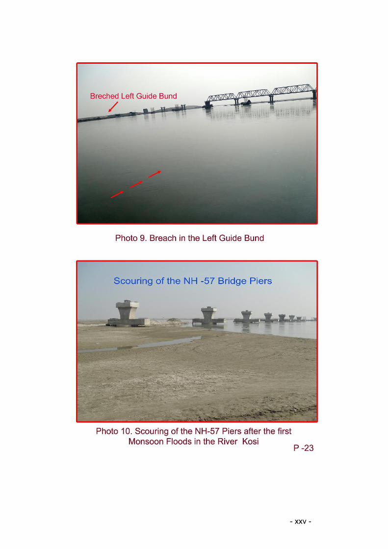
eastern guide bunds (Ref Photo 9) and village Naua Bakhar further approximately 2
Km downstream. There was evidence of scouring of the NH-57 Bridge piers, upstream
of the Railway Bridge, after the first monsoon floods (Ref. Photo 10).
8.4 Normally a braiding river, with high sediment flux like that of the Kosi,
starts forming sinusoidal dunes in flow direction with reducing discharge after the
flood. If the pier of the Bridge at the selected site lies in the trough of the dune, the
scouring of the pier is accelerated (Ref 3). The formation of shoals downstream of the
Bridge and consequent change in the fluvial characteristics and behavior of the
channel is continuation of this phenomenon. The physical model testing and the
mathematical analyses are recommended with varying sediment load, slope and
discharge of the river, both upstream and down stream of the proposed highway
intersection, in order to predict pre and post structural intervention response of the
- x -
channel. The necessity for carrying out this study before finalizing the site and
waterway of the Bridge was highlighted by experts in the Ganga Flood Control
Commission (GFCC) too, whose views were communicated to NHAI and the Indian
Railways by Sri Bhagwan Das, Chief Engineer, Central Design Organization, WRD,
Bihar in his letter #923 dated 5 Aug 2003 as follows:
“The Chairman, GFCC pointed out that from the model test it appeared that the
Approach Embankment to be constructed on both side of two proposed bridges which
are extending into the course of the river and the waterway will be restricted to about
2Km. Even though this width may be adequate from the Lacey’s width point of view,
still it will be prudent to study the behavior of the river after it comes out of the
narrowed down passage in downstream areas”
8.5 The Technical imperatives for reconsidering the proposed waterway width of 1853
m as well as its impact on the morphology of the river and safety of the marginal
embankments were again highlighted by the Chief Engineer, Central Design
Organization, WRD, Bihar in his letter #1079 dated 1.09.2003 to GM (EW III), NHAI,
New Delhi as follows: “----we have examined the matter regarding providing adequate
waterway in the construction of proposed new bridge across river Kosi. Ganga Flood
Control Commission has advised that apart from impact studies of the proposed
bridge, it is necessary to get the impact assessment done downstream also. In this
connection our examination of the issues has revealed that serious problem may arise
both upstream and downstream of the bridges as in the case of the Road bridge over
Ganges at Patna and the Road-cum –Rail bridge at Mokamah. Subsequent to our
letter we have also found that in the proposed region of construction siltation is a very
serious problem and as a consequence the freeboard of the embankment has already
diminished subsequently. Hence, the broader base of the embankment has merged
with the river bed and the top narrow portion now bears the brunt of pressure of flood
water. As a result HG line has also shifted and become more obtuse. We are
therefore, of the opinion that afflux upstream be kept at naught. This will call for
redesigning the bridge to provide more waterways. This may somewhat push up the
initial cost but result in saving crores of rupees in anti- erosion , flood fighting and relief
work in future. The state is already facing serious consequences of post economics of
design in construction all along river Ganges between Digha and Munger and Gandak
at Dumariaghat”.
8.6 The Expert Committee under the Chairmanship of Gokhul Prasad had also
recommended model study of the upstream and down stream impact of the proposed
waterways by CWPRS before freezing the design options of the proposed Bridge
(Ref.2). The constricted waterway design of the Bridge was favored by the Technical
Committee principally for economic advantages such a design offers. Lacey’s
Waterway equation for the Channel width as well as waterway lengths of the
Bhimnagar Kosi Barrage, Dumarighat Bridge (on NH 107), Kursela Bridge (on NH 31)
and Railway Bridge at Kursela over the River Kosi were considered by the Technical
Committee as examples for technical justification for “capping length of 2000 meters”
- xi -
for the NH-57 and Railway Bridge at Nirmali (Ref 5). The Kosi Barrage has a width of
1148 m between the abutments. The upstream pond, expanding up to plains at
Chatra, which is approximately 42 km away from the Barrage, has an approximate
pond age area of 39 500 Hectare which cushions the flood as well as impounds the
sediment. The river width upstream of the Barrage is 6940 meter, with afflux bunds on
both banks. The pond level was designed for 6.09 m (Ref 6). In case of the NH-57 and
the Rail Bridge over the River Kosi, the width of the River at the selected site was
approx. 10 km. Further, upstream of the Bridge and between the eastern and western
embankments, there is human habitation up to the Barrage in approximately 38 000
Hectare. Approximately sixty percent of this area is agricultural land (Ref 1). The
Constricted Flow design of the Bridge at this site was likely to give rise to high level of
afflux, affecting human population apart from its other ramifications discussed in
subsequent paragraphs. Therefore the analogy of the shorter waterway provided for
the Kosi Barrage was not applicable for the design of waterway of the NH-57 and the
Railway Bridge at Nirmali.
8.7 The span of the Dumarighat Bridge over the River Kosi on the NH-107 was 963.4
m (not 900 m as informed to the Technical Committee and referred in the minutes of
the third meeting, held on 20.12.2002, Ref 5). This Bridge was designed for river
discharge of 19 900 cumecs. The comparison of waterway of Dumarighat Bridge with
that of proposed NH- 57and the Railway Bridge was not appropriate, firstly because
the Technical Committee had already accepted higher design discharge, i.e. 22 375
cumecs for the later Bridges. Secondly, the design of the waterway of the Dumarighat
Bridge was itself inadequate because of the underestimation of the river discharge. At
this river cross section, the River Kosi, apart from its own discharge from Bhimnagar
Barrage carries the combined discharge of the Rivers Trijuga, Bihul, Bhutahi Balan,
Kamla-Balan and Kareh (Bagmati) as well. Therefore the maximum (design) discharge
of 19 900 cumecs for Dumarighat Bridge waterway design was gross under estimate.
Subsequent events of scouring of foundation of five piers of this Bridge after less than
20 years of its service life, and their sinking down with modest river discharge of
approximately 9900 cumecs in the monsoon of the year 2010 reveal the design
deficiency of the Dumarighat Bridge waterway. The Technical Committee of the NH-
57/ Railway Bridge put the cap on the waterway length of 2000 m for these Bridges,
which was subsequently reduced to 1853 m, sighting an analogy which was not
applicable. The geohydromorpho-dynamic conditions of the River, which prevailed at
the time of washing away of the first railway bridge in Nirmali- Bhaptiyahi route (in the
year 1938) and scouring of the piers of NH-107 Bridge in the year 2010, could offer
valuable technical inputs for undertaking any future structural interventions in the flow
of the Kosi.
8.8 The Lacey’s equations for computing the width of the Bridge waterway, referred by
the Technical Committee as well as GFCC are valid for a regime of stable channels in
a state of dynamic equilibrium. There have been many improvements of the Lacey
- xii -

equations to define the regime channels (Ref 7). The River Kosi is unstable with high
sediment load of varying grades in the regime. Even after it was embanked, its multi
channels are constantly changing course within the confines of 10-15 km. In the River
Cross Section 37/38, there were five channels of the River. Four of these channels
were proposed to be plugged by constructing the afflux cum protection embankments
of the NH-57. The Bridge was proposed over the fifth channel, which was also the
main and central channel of the River. Therefore application of Lacey’s equation for
calculating the Bridge waterway for only one channel and ignoring remaining four
channels of the River Kosi was of questionable merit.
9. REVIEW OF DESIGN DISCHARGE FOR THE BRIDGE
9.1 It was decided by the Technical Committee in their second meeting held on
23.10.2003 that since the Design Discharge adopted for the Kosi Barrage was 26 900
cumecs, this discharge should be adopted for the purpose of the foundation design of
both the bridges As far as Design Discharge for the waterway was concerned, it was
decided in this meeting that mathematical modeling should be done for discharge
corresponding to 100- Year, 50- Year and normal flooding Return Intervals (RI) (Ref
8). The River Discharge for this RI was not specified. It was mentioned in the minutes
of the third meeting of the Technical Committee held on 20.12.2002, “additional model
runs with 100 year return period design discharge of 22 375 cusecs (cumecs) (7.9 lacs
cfs) were taken up by CWPRS, which shows that the length of the bridge /waterway
required is 2000 metres to avoid overtopping of flood embankments except at isolated
locations” (Ref 5). The CWPRS was aware of the fact that the River Kosi had
exceeded this discharge three times during last less than 50 years, i.e. during the year
1954,1968 and 1987 (Ref 9, Para 4.9, Design Discharge ). Therefore the basis of
arriving at discharge of 22 375 cumecs for 100- year RI for model testing and
mathematical analysis is not clear.
9.2 The Kosi Barrage was designed and constructed in the 1950s and 1960s. Based
on the analysis of the data available up to that time, the design discharge of 26 900
cumecs for the Barrage would have been arrived at. The highest discharge of the
River, available at that time in records was 24 220 cumecs (8 55 226 cusecs), which
had been reached during monsoon of the year 1954. In subsequent years, the River
flood discharge had exceeded this record twice. It touched 25 856 cumecs (9 12 994
cusecs) in the year 1968, and 25 652 cumecs (9 05 791 cusecs) in the year 1987. The
available data on the annual peak river discharge measured at Varahkshetra from the
year 1947 to 2007 (total 61years), and the estimation of discharge for 100- year RI
are placed as Annexure III and IV respectively. It could be noted that the discharge of
22 375 cumecs for RI of 100 years, which was presented to the Technical Committee
and used by CWPRS Pune for physical model testing and mathematical simulation,
was gross underestimation for the Bridge waterway design. Moreover the discharge
for 100 years RI would always be higher than that for 50 years or less period of RI,
unless the flood incidences of the year 1954, 1968 and 1987 are deliberately omitted
from domain of flood frequency analysis. An independent study on “Flood Hazards of
- xiii -
North Bihar Rivers, Indo-Gangetic Plains”, carried out by Sinha, Rajiv and Jain, Vikrant
(Ref 10) put the River Kosi discharge for the RI of 100 years as 24 913.75 Cumecs at
the Barrage. Therefore the physical model tests and mathematical analysis carried out
at CWPRS based on River discharge of 22375 cumecs for 100-year RI wouldn’t
correctly reflect the river stage.
9.3 The under estimation of the design discharge would result in higher severity of the
constriction of waterway of the Bridge. The ‘Guide to Bridge Hydraulics’ (Ref 11)
states : ‘In general, the more severe the constriction, the deeper will be the scour and
required foundations, and the more expensive will be the channel control works. If the
natural waterway is too severely constricted, the additional cost of the channel control
works and future maintenance may exceed the savings on structure.’ The breach of
the eastern Afflux cum protection bund, Guide bunds and approach of NH-57 and
onset of the pier scour of the Bridge at less than one third of the design discharge of
the river in the last monsoon (year 2010) corroborate the above prophetic
statements.
10. FLOW PROFILE IN THE INLET GUIDE BUNDS
10.1 During the physical model test at CWPRS, the right as well as left guide bunds
was instrumented for measurement of flow velocities at ten critical locations along
each bund. The channel width between the two guide bunds was 1917 m. It was found
that at design discharge of 22 375 cumecs, the velocity was higher than 1.2 m/s at
seven locations on the left and right banks each. The maximum velocity was 3.84
m/sec, observed at upstream inlet on the left guide bund. Similarly, on the exit end of
the right guide bund, the velocity was found to be 3.18 m/sec (Ref 14, Table 3). The
Erosion Threshold Velocity (Ve) is generally between 0.3 to 0.6 m/sec for fine sand to
coarse sand bank material and 1.2 m/sec or higher for Clay as bank material in
channel flow. Similarly the competent mean velocity for scouring of the piers of the
Bridge in the flow depth of 1.5- 6 m for easily erodible material is 0.6-0.7m/sec. (Ref
15).The velocity measured during the model test in the lab were very high for the
alluvial channel of the Kosi in the aforesaid flow depth range and conducive for the
onset of scouring of the Bridge piers, bank avulsion and soil erosion downstream. With
the present waterway of 1853 m, the severity of these parameters would further
increase once the River discharge inched towards its previous records. The fluvial
characteristic in the waterway guide channel is a function of the flow area, bed slope,
material and sediment load and grade. The onset of shoal formation downstream of
the Railway Bridge, scouring of the piers, and oblique and high exit velocity flow
breaching the tail end of left guide bund, and erosion of houses in the Village Naua
Bakhar 2km downstream were indication of serious design problem with the waterway.
10.2The Indian Railway Standard “Code of Practice for the Design of Substructures
and Foundation of Bridges” (issued by RDSO, Lucknow), Para 4.2 Estimates of
Design Discharge (Q), clause 4.2.2 stipulates: “All bridges shall be designed with
adequate waterway for design discharge (Q). This shall normally be computed flood
with a probable recurrence interval of 50 years. However, at the direction of Chief
- xiv -
Engineer/ Chief Bridge Engineer, bridges, the damage to which is likely to have severe
consequences may be designed for floods with a probable recurrence interval of more
than 50 years , while bridges on less important lines or sidings may be designed for
floods with a probable recurrence interval of less than 50 years.” The waterway design
for the bridge over the Kosi at Nirmali by ignoring the discharge levels of 1954,1968
and 1987, as explained in Para 9 above, were violation of the Railway Design
Standards. Similarly Para 4.8 Clearance ‘C’ under clause 4.8.1 table of discharge in
cumecs versus vertical clearance (mm) of this Standard lays down for “discharge
above 3000 cumecs-vertical clearance 1800 mm”. The clearance ‘C’ has been defined
in Para 2, clause2.3, as “the vertical distance between water level of the design
discharge (Q) including afflux and the point on the bridge superstructure where the
clearance is required to be measured. (Ref 16). The CWPRS was supplied the
drawing by NHAI for model testing which specified this clearance, i.e. the difference
between the HFL and the Soffit Level, as only 1000 mm (Ref 9, Para 3.3). Thus in
correct data were used for the Bridge model testing; violating the Indian Railway
Standard Code for the design of Bridges.
11. CONCLUSION
11.1 The Design Discharge of 22 375 cumecs (7 90 000 cusecs) of the River Kosi for
Return Interval (RI) for 100-year is an under estimate. This needs to be re examined.
11.2 The gross waterway of 1853 meters for the Bridge (29spans@ 61m clear width
plus 28 piers @ 3.0 m width), is inadequate even at the design discharge mentioned
above. This should be reviewed.
11.3 The predictions of Backwater effect over a distance 8 km and afflux of 1.35 m at
the Design Discharge of 22 375 cumecs, based on the physical model tests and
mathematical analysis conducted at CWPRS were found not realistic. During the
monsoon of the year 2010, even at about twenty percent of the Design Discharge of
the waterway, the Backwater spread up to villages located 15 km upstream and afflux
rose to approximately 5 m height, inundating several villages.
11.4 The River Kosi hydrologic data between the Barrage and the NH-57 Bridge site
were gathered between pre and post monsoon months of 2002. The River bed and
flood plain gradients, channel branching and Ana branching, locations and area of
shoals, grading of sediments, bank slope and vegetation, and consequently the
Manning’s ‘n’ have altered in the course of last 8 years. Therefore the accuracy as well
as validity of data used by CWPRS Pune for Physical model preparation and testing
as well as for establishing Gage –Discharge relationship at Bhaptiyahi and Dagmara,
prediction of upstream river stage and topping of the segments of the eastern and
western Kosi Embankment should be reviewed.
11.5 After due considerations, the Government of Bihar, Department Of Water
Resources, had taken a stand that the back water effect up to 8km and the afflux level
of 1.35 m were not acceptable. The afflux should be brought to zero. This had been
communicated to the NHAI and the Railways. The CWPRS had then carried out
- xv -
further studies on their (NHAI-Railway’s) advice and came out with the solution of
having longer Waterway of 10320 m for the bridge in order to avoid backwater and
afflux. The reasons for revision of the stand taken by the Government of Bihar and not
choosing the option of longer waterway for the Bridge weren’t clear.
11.6 The underestimation of the design discharge and the inadequate waterway for
the Bridge at Dumarighat over the River Kosi on NH 107 led to scouring and collapse
of five piers in less than 20 years of service of the Bridge. The Railways as well as
NH-57 Bridges over the River Kosi at Nirmali are yet to be completed. Therefore
taking cue from this failure as well as hydrologic conditions of the River during the
course of last monsoon, design configurations of the Bridges should be reviewed.
MB VERMAFormer Distinguished Scientist DRDO Program Director TEJAS LCADirector ADA Bangalore Email: [email protected]
LIST OF REFERENCES
1. Mishra, DK (2006), ’Kosi Nadi Ki Kahani, Dui Patatan Ke Bich Mein’, Lok Vigyan Sanstha, Dehradun
2. Gokhul Prasad Expert Committee Report on Road and Rail Bridge On the River Kosi near Nirmali in Darbhanga Forbesganj Section of NH- 57 (2004), Govt. of Bihar Water Resources Department.
3. River Engineering for Highway Encroachments, Highway in the River Environment Hydraulic Design Series No. 6 (Dec 2001), USDT Federal Highway Administration, Publication N0. FHWA NHI 01- 004
4. Sanyal N. (1980) Effect of Embankment of River Kosi, proceedings of the International Workshop on Alluvial River Problems.
5. Minutes of the 3rd meeting of the Technical Committee on Rail-cum RoadBridge on River Kosi held on 20/12/2002 (Para 2, See annexure I for ready reference).
6. Galgali, V.G, River Training and Flood Regulation on the Kosi, 53 rd Annual R&D Session CBIP.
7. Subramnya, K, (1997) Flow in open channels TATA McGraw Hill, page 506
8. Minutes of the 2nd meeting of the Technical Committee on Rail-cum Road Bridge on River Kosi held on 23/10/2002 (Para 2 and 3, see annexure II for ready reference).
9. Model Studies for Proposed Road and Rail Bridge on Kosi River, Niramali Bihar (March 2003), Central Water and Power Research Station Pune, River Engineering Lab Technical Report N0. 3982.
- xvi -
10. Sinha, Rajiv and Jain, Vikrant, (1998), Flood Hazards of North Bihar Rivers-Indo Gangetic Plains, Geological Society of India No. 41, 19981PP27-52.
11. Guide to Bridge Hydraulics (2004) Thomas Telford Publication, Transport Association of Canada
12. Govt of Bihar Jalsansadhan Bibhag, Letter No. 1090, Dated 11/09/2003 from Commissioner and Secretary to Member Technical NHAI New Delhi.
13. CWPRS Model Studies for the Proposed Twin Road Railway Bridge on River Kosi near Nirmali, N0. JD/MSS/2003/7760, Dated 27/08/2003
14. CWPRS Technical Report No. 4119 (June, 2004, Model Studies for extension of Guide Bunds of Proposed Road and Rail Bridges on Kosi River, Niramali, Bihar.
15. Bridge Hydraulics by Les Hamill E & FN Spon, UK
16. Code of Practice for design of structures of foundation of Bridge, Indian Railway Standard, RDSO, Lucknow.
Annexure I
Extract of minutes of the 3rd meeting of Technical Committee held on 20/12/2002 (Ref 5)
Para 2
“As decided during previous meeting, additional model runs with 100 year return
period design discharge of 22375 cumecs (7.9 lacs cfs) were taken up by CWPRS,
which shows that the length of the Bridge/ Waterway required is 2000 meters to avoid
overtoping of flood embankments except at isolated locations.
The bridge length of 2000 meters suggested above was felt too long considering that
the length of the existing road and rail bridges on the downstream of the proposed
Kosi Bridge was reported as 900 meters only and they were functioning satisfactorily.
The members were also of the opinion that keeping in view the aggrading nature of
the river (in which shoals were reported to be appearing even at a discharge of 3 to
3.5 lac cuces), afflux and free board alone should not be the criteria for model analysis
for deciding the waterway, since the scouring of river bed is likely to counter act the
effect of afflux to a good extent,. It was also noted that the length of Kosi barrage is
only 1150 meters, which is much less than the suggested waterway of 20000 meters.
It was pointed out by the representative of CWPRS that bridge at the present location
would be more affected by flash floods than the bridges at the downstream location
with more stable/uniform flow conditions exiting there.- xvii -
After prolonged deliberations, it was decided that physical model studies would be
carried out for bridge length of 1200 meters, 1600 meters and 2000 meters keeping in
view the flow and scouring pattern, flood pattern and afflux in the three dimensional
model and the optimum bridge length/waterway would be decided based on the
physical model analysis with a capping length of 2000 meters. It was also decided that
the length and configuration of guide bunds for each of the above alternatives would
be evolved based on the physical model studies and submitted along with report.
Action: CWPRS”
Annexure II
Extract of minutes of the 2nd meeting of Technical Committee held on 23/10/2002 (Ref 8)
Para 2
“The design discharge adopted for the Kosi barrage (width 1149m) is reported as
26900 cumecs. It was suggested by the Committee that this discharge may be
adopted for the purpose to foundation design of both bridges and for deciding the
spacing between the twin bridges, as recommended by CWPRS. Meanwhile, CWPRS
would in its final report give detailed justification for the design discharge of 26
900cubicmetre per second along with a comparison of discharge data at the
downstream locations (D/S of c/s 37&38) at Kursela and Dumarighat. The parameters
for design of waterway, guide-bunds, approach embankment and other protective
works for river training would be based on the design discharge of 100 year return
period.
Action: CWPRS/ANHI/Railways”Para 3
“CWPRS have suggested a waterway of 2400m in their mathematical model study
report. Considering the a aggrading behavior of the river, it was suggested that
CWPRS would review the water way requirement after carrying out further
mathematical model studies using the discharge of 100 year period and
corresponding afflux, spread of back water, level of existing flood embankments, guide
bunds & other required river training works, along Kosi river, Model study would also
be carried out for discharges corresponding to normal flood conditions, 50 years
return period and 100 years return period. The waterways adopted for the existing
- xviii -
road bridges at Kursela, Dumarighat and Railway bridge at Kursela are also to be
obtained from the respective authorities for comparison purpose. Modified
mathematical model study report has to be submitted by CWPRS by the 3 rd week of
Nov. 2002 Action: CWPRS”
Annexure III(Sheet 1 of 2)
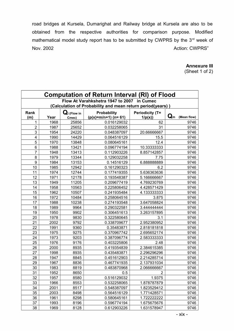
Computation of Return Interval (RI) of FloodFlow At Varahkshetra 1947 to 2007 in Cumec
(Calculation of Probability and mean return period(years) )
Rank (m) Year
Qi (Flow in Cmec)
Probability (p(x)=m/n+1) (n= 61)
Periodicity (T= 1/p(x)) Qm (Mean flow)
1 1968 25856 0.016129032 62 97462 1987 25652 0.032258065 31 97463 1954 24220 0.048387097 20.66666667 97464 1990 14429 0.064516129 15.5 97465 1970 13848 0.080645161 12.4 97466 1988 13421 0.096774194 10.33333333 97467 1948 13413 0.112903226 8.857142857 97468 1979 13344 0.129032258 7.75 97469 1984 13153 0.14516129 6.888888889 9746
10 1985 12942 0.161290323 6.2 974611 1974 12744 0.177419355 5.636363636 974612 1971 12178 0.193548387 5.166666667 974613 1949 11205 0.209677419 4.769230769 974614 1958 10563 0.225806452 4.428571429 974615 1962 10507 0.241935484 4.133333333 974616 1972 10484 0.258064516 3.875 974617 1988 10238 0.274193548 3.647058824 974618 1989 9964 0.290322581 3.444444444 974619 1950 9902 0.306451613 3.263157895 974620 1978 9830 0.322580645 3.1 974621 2002 9792 0.338709677 2.952380952 974622 1991 9360 0.35483871 2.818181818 974623 1975 9275 0.370967742 2.695652174 974624 1973 9203 0.387096774 2.583333333 974625 1976 9176 0.403225806 2.48 974626 2000 8935 0.419354839 2.384615385 974627 1998 8935 0.435483871 2.296296296 974628 1947 8845 0.451612903 2.214285714 974629 1967 8836 0.467741935 2.137931034 974630 1983 8819 0.483870968 2.066666667 974631 1952 8650 0.5 2 974632 1957 8580 0.516129032 1.9375 974633 1966 8553 0.532258065 1.878787879 974634 2001 8517 0.548387097 1.823529412 974635 2003 8498 0.564516129 1.771428571 974636 1961 8298 0.580645161 1.722222222 974637 1993 8196 0.596774194 1.675675676 974638 1969 8128 0.612903226 1.631578947 9746
- xix -

39 2004 8111 0.629032258 1.58974359 974640 1997 8070 0.64516129 1.55 974641 1981 7991 0.661290323 1.512195122 974642 1977 7778 0.677419355 1.476190476 974643 1980 7706 0.693548387 1.441860465 974644 1963 7646 0.709677419 1.409090909 974645 1995 7576 0.725806452 1.377777778 974646 1957 7533 0.741935484 1.347826087 974647 1986 7360 0.758064516 1.319148936 974648 1951 7257 0.774193548 1.291666667 9746
49 2007 7252 0.790322581 1.265306122 974650 1955 7080 0.806451613 1.24 974651 1982 6970 0.822580645 1.215686275 974652 1994 6896 0.838709677 1.192307692 974653 1992 6896 0.85483871 1.169811321 974654 2005 6648 0.870967742 1.148148148 974655 1960 6627 0.887096774 1.127272727 974656 1959 5976 0.903225806 1.107142857 974657 1965 5749 0.919354839 1.087719298 974658 1964 5706 0.935483871 1.068965517 974659 1956 5437 0.951612903 1.050847458 974660 1953 5421 0.967741935 1.033333333 974661 2006 4305 0.983870968 1.016393443 9746
Total 594480
Annexure IV
- xx -
Annexure III (Sheet 2 of 2)

LIST OF PHOTOGRAPHS
- xxi -
1. Photo 1. The River Kosi Discharge Gage Reading at Bhimnagar Barrage on 17.08 2010 at 1200 Hrs.
2. Photo 2. River Discharge Display Board at Bhimnagar Barrage on 17.08 on 17.08.2010.
3. Photo 3. Back Water Upstream of the NH 57 and Railway Bridge over the River Kosi at Nirmali. (Celerity waves at sub critical flow could be discerned at red arrows).
4. Photo 4. The village Sanpataha submerged in the Afflux of Backwater of the River Kosi.
5. Photo 5. Flooded houses in the village in the Afflux of Backwater of the River Kosi.
6. Photo 6.Spread of sand in the agricultural land.
7. Photo 7.Breach in the Left Afflux cum Protection Embankment of the NH 57..
8. Photo 8. Shoal Formation Downstream of Railway Bridge Piers
9. Photo 9. Breach in the Eastern Guide Bund
10. Photo 10. Scouring of the NH-57 Piers after the first Monsoon Floods in the River Kosi
LIST OF FIGURES
1. Structural intervention in Kosi Flood Plain
- xxii -
- xxiii -
- xxiv -
- xxv -