Embed Size (px)
Citation preview

REPORT TO
3D QLD TASKFORCE
12 AUGUST 2018
3D QLD ROAD MAP
PHASE B DEVELOPMENT PHASE

ACIL ALLEN CONSULTING PTY LTD
ABN 68 102 652 148
LEVEL NINE
60 COLLINS STREET
MELBOURNE VIC 3000
AUSTRALIA
T+61 3 8650 6000
F+61 3 9654 6363
LEVEL ONE
50 PITT STREET
SYDNEY NSW 2000
AUSTRALIA
T+61 2 8272 5100
F+61 2 9247 2455
LEVEL FIFTEEN
127 CREEK STREET
BRISBANE QLD 4000
AUSTRALIA
T+61 7 3009 8700
F+61 7 3009 8799
LEVEL ONE
15 LONDON CIRCUIT
CANBERRA ACT 2600
AUSTRALIA
T+61 2 6103 8200
F+61 2 6103 8233
LEVEL TWELVE, BGC CENTRE
28 THE ESPLANADE
PERTH WA 6000
AUSTRALIA
T+61 8 9449 9600
F+61 8 9322 3955
161 WAKEFIELD STREET
ADELAIDE SA 5000
AUSTRALIA
T +61 8 8122 4965
ACILALLEN.COM.AU
SUGGESTED CITATION FOR THIS REPORT
ACIL ALLEN CONSULTING (2018) 3D QLD ROAD MAP, PHASE B, 3D QLD TASK FORCE
© ACIL ALLEN CONSULTING 2017

C O N T E N T S
GLOSSARY OF TERMS I
EXECUTIVE SUMMARY VI
1
Introduction 1 1.1 Terms of reference for Phase B 1 1.2 Contents of this report 2
2
Findings of Phase A revisited 3 2.1 Introduction 3 2.2 Vision 3 2.3 The economic potential 3 2.4 The case for an integrated approach to a 3D Qld 5 2.5 What would a 3D world deliver for the public and consumers? 5
2.6 Cadastral Queensland Transformation Program (CQT) 5 2.7 Longer term Challenges and Solutions identified by Stakeholders 6 2.8 Identification of the Products of 3D Qld 6 2.9 Security 7 2.10 Appetite for change 7
3
Questions raised in the terms of reference 9 3.1 Introduction 9 3.2 The need for collaboration 9 3.3 Critical issues that may require regulation 10 3.4 Issues that require consideration 12 3.5 Options to create the 3D Qld Vision 13 3.6 Preferred option 14 3.7 Business model to pay for 3D models of the DBE 15 3.8 Government involvement 15 3.9 A longer-term view: Models of the DBE as Infrastructure 15
4
The Road Map 17 4.1 Introduction 17 4.2 Priorities for a Coordinated Implementation 17 4.3 The Road Map 18 4.4 Pilot projects 23 4.5 Possible DBE Model Proof of Concept 24 4.6 Roles and Responsibilities of the Parties 25 4.7 Timetable 27 4.8 Skills and capabilities 28 4.9 Anticipated Costs 29 4.10 Key Performance Indicators 29

C O N T E N T S
4.11 Risk Management 30
5
Summary and recommendations 32 5.1 Introduction 32 5.2 Road Map architecture 32 5.3 Potential Longer Term Uses 33 5.4 Technical and Governance/Legislative issues 33 5.5 National Implications 34 5.6 Implementation Recommendations 34
REFERENCES 36
A
Why a shift from 2D to 3D 37 A.1 Why a shift from 2D to 3D? 37 A.2 Why is Authoritative 3D and spatial data integration such an important step for this digital future? 37
B
Longer term Possibilities B–1 B.1 Imagining Life in 2040 B–1
C
Taskforce and conulting team C–1 C.1 Taskforce members C–1 C.2 Consulting team C–1
FIGURES FIGURE 2.1 AREAS OF POTENTIAL FOR GREATER INTEGRATION AND COLLABORATION BASED ON THE 3D
QLD VISION 4 FIGURE 4.1 THE ROAD MAP 22 FIGURE 4.2 OVERSIGHT ARRANGEMENTS FOR PILOT PROJECTS 26
TABLES .
TABLE 4.1 ACTIONS AND TIMEFRAME 27 TABLE 4.2 KEY PERFORMANCE INDICATORS FOR 3D MODELS OF THE DBE 30

3D QLD ROAD MAP PHASE B i
G L O S S A R Y O F T E R M S
Term Definition
3D Data Data representing the physical attributes of the natural and built environment in
3 dimensions, as well as all RRR boundaries.
3D Qld ‘Three Dimensional Queensland' is a project that aims to build on successful centuries old land surveying practice and law, transitioning to a modernised and efficient system suitable to meet the needs of the 21st century. It will be realised in part by land surveying professionals incorporating survey accurate, three dimensional measurements on the earth into their everyday practice and presenting this in a digital format. Ultimately, a potential outcome envisioned by 3D Qld is 'An authorised, federated, secure, digital 3D model (of the natural and built environment, including all RRR) with high positional certainty'.
3D Qld Taskforce A task force comprising representatives from the Surveying and Spatial
Sciences Institute Qld division, the Spatial Industries Business Association, the
Australian Institute of Mine Surveyors, the Surveyors Board of Qld, the
Queensland Spatial and Surveying Association (QSSA) and the Department of
Natural Resources, Mines and Energy. The purpose of the Taskforce is to
realise the 3D Qld vision through the preparation of a Road Map.
ABS Australian Bureau of Statistics.
ADAC Asset Design and As Constructed - a local government focused data
specification, mainly used in Qld.
AEC Architecture, Engineering and Construction.
Agile Development An umbrella term for several iterative and incremental software development
methodologies. The most popular agile methodologies include Extreme
Programming (XP), Scrum, Crystal, Dynamic Systems Development Method
(DSDM), Lean Development, and Feature-Driven Development (FDD).
AI Artificial Intelligence is a branch of computer science dealing with the simulation
of intelligent behaviour in computers, with the capability to imitate intelligent
human behaviour to some degree. A General AI is defined to have an
intelligence like (or better than) a human.
AIMS Australian Institute of Mine Surveyors.
AMCA Air Conditioning and Mechanical Contractors’ Association.
API Application Programming Interface
A-Spec Standardised approach to specifying roads, drainage, open space, water,
sewerage and buildings. It is used across many jurisdictions in Australia (mainly
Victoria and Western Australia), as well as Wellington in New Zealand.
BIM Building Information Modelling, a process involving the generation and
management of digital representations of physical and functional characteristics
of places.
BIM-MEPAUS Building Information Modelling-Mechanical and Electrical Australia, and initiative
of AMCA to develop specifications that define plant, equipment and fittings for
essential building services (mechanical, electrical and plumbing).

3D QLD ROAD MAP PHASE B ii
Term Definition
Blockchain An electronic public ledger of all transactions that have ever been executed. It is
constantly growing as 'completed' blocks are added to it with a new set of
recordings. It was first used to create a digital currency (Bitcoin) but is now
being modified for other uses to decentralise document processing – enabling
the process to be sped up at much reduced cost and without the need for a
‘trusted third party’ to hold the official record.
BMS Building Management System
Cadastre Provides the most fundamental information on land tenure, establishing unique
boundaries for the principal RRR that apply to it.
CQT Cadastre Queensland Transformation project to determine DNRME’s future
approach to how land information e.g. property, surveying and addressing data,
is created and used by different people and organisations. The project aims to
develop a system that enables the industry to use and contribute spatial
information, which will build a resource that will have benefits for everyone.
CityGML Standard for delivering city-scale 3D models through the Web
CORS Continuously Operating Reference Stations (together with GNSS satellites and
new receivers and algorithms) enable precise point positioning over the whole
country
CRCSI The former Cooperative Research Centre for Spatial Information
CSG Coal Seam Gas
DBE Digital Built Environment is a 3D Computer Model of the Natural and Built
Environment (inside and out, above and below ground) that includes all RRR
boundaries - on all scales required for decision-making - linked to global
position and elevation grids.
DBE Workgroup Workgroup comprising representatives of key stakeholders set up to help
develop the Governance Framework for the DBE
DCDB Digital Cadastral Data Base. It is created and maintained by the DNRME and
currently exists only in 2D. It represents the compilation of all lots into a single
seamless ‘fabric’, without gaps or overlaps and includes some restrictions.
Discount Rate Rate of Return used to discount future cash flows to current dollars.
DNRME Queensland Department of Natural Resources, Mines and Energy
DNRME Project Cadastre Queensland Transformation project (CQT)
EARL Former name for the electronic lodgement of survey plans in Qld, now called
eSurvey
eConveyancing Private practices set up to manage electronic property transactions
eGeodesy A project of the Permanent Committee on Geodesy (PCG) of the Australian and
New Zealand Intergovernmental Committee on Surveying and Mapping (ICSM)
to develop a standards-based approach for the exchange of geodetic data and
metadata within Australia and New Zealand.
ePlan Standard and system for the electronic lodgement of plans and planning
enquiries
eSurvey Standard and system for the electronic lodgement of plans in Qld.
Federated Made up of many different linked data sets under the control of many different
entities (public and private) who have a vested interest in maintaining their own
source data.
Flagstone The Greater Flagstone Priority Development area covers a total area of 7188
hectares to the west of the Jimboomba and the Mount Lindesay Highways,
along the Brisbane-Sydney rail line. When fully developed it is anticipated that it
will provide approximately 50,000 dwellings to house a population of up to
120,000 people.

3D QLD ROAD MAP PHASE B iii
Term Definition
GDA2020 Geocentric Datum of Australia 2020, a new dynamic reference frame that can
account for mm shifts of the whole continent of Australia, as well as local
ground movement, over time. This supports improved dynamic positioning of
boundaries and elevations relative to an agreed datum (a coordinate reference
frame) that has a known relationship to the whole Earth.
(http://www.icsm.gov.au/geodesy/modern.html)
GE General Electric Company.
Geo-referencing The process of assigning spatial coordinates to data that is spatial in nature. In
Australia, the coordinates proposed to be used are those within the new
GDA2020 Dynamic Datum.
Geoscape A new initiative from PSMA that captures the observed built environment and
anchors it in a reliable geospatial base. The dataset includes 3D building
attributes, land cover and tree heights. Geoscape also captures features such
as roof materials, swimming pools and solar panels.
GIS Geographic Information System, a computer system for capturing, storing,
checking, and displaying data related to positions on Earth's surface.
GNSS Global Navigation Satellite System that triangulates signals from satellites and
ground stations to deliver real-time precise point positioning.
Hackathons An event in which computer programmers and others involved in software
development, including graphic designers, interface designers and project
managers, collaborate intensively on software projects. Occasionally, there is a
hardware component as well.
IaaS Infrastructure as a Service is a form of cloud computing that provides virtualized
computing resources over the Internet.
ICSM Inter-governmental Committee on Surveying and Mapping.
IFC Industry Foundation Class is an object-based file format with a data model
developed by buildingSMART International to facilitate interoperability in the
architecture, engineering and construction (AEC) industry.
IndoorGML A new standard that supports way-finding and emergency egress in buildings.
InfraGML A possible replacement for LandXML, designed specifically to address the
modelling of broader infrastructure elements of the environment.
IoT Internet of Things, a proposed development of the Internet in which everyday
objects have network connectivity, allowing them to send and receive data.
Landgate Comprehensive electronic Land Administration system, including standards and
system for the electronic lodgement of plans in WA.
LandXML XML stands for Extensible Markup Language. It is a file format used to create
common information formats and share both the format and the data on the
World Wide Web, intranets, and elsewhere using standard ASCII text. XML is
similar to HTML. LandXML provides the standards that relate specifically to
data files relating to land and buildings.
Lidar Light Detection And Ranging is a detection system which works on the principle
of radar but uses light from a laser to measure distances to points on the
surface of objects that reflect the laser light.
MOOC Massive Open On-line Courses, some of which provide world class STEM
training, with the option to pay for assessment to gain a recognised
qualification.
Moore’s Law Moore’s Law is the observation that the number of transistors in a dense
integrated circuit doubles approximately every two years.
MOU Memorandum of Understanding is a formal agreement between two or more
parties that are not legally binding but set out the party’s joint intent.

3D QLD ROAD MAP PHASE B iv
Term Definition
National Map A website for map-based access to spatial data from Australian government
agencies
NIEIR National Institute of Economic and Industry Research
NPV Net Present Value.
OGC Open Geospatial Consortium.
PaaS Platform as a service is a category of cloud computing services that provides a
platform allowing customers to develop, run, and manage applications without
the complexity of building and maintaining the infrastructure typically associated
with developing and launching an app.
PCA Property Council of Australia
PCG Permanent Committee on Geodesy of the Australian and New Zealand
Intergovernmental Committee on Surveying and Mapping (ICSM) to develop a
standards-based approach for the exchange of geodetic data and metadata
within Australia and New Zealand.
PEXA Property Exchange Australia is Australia’s online property exchange network. It
assists members – such as lawyers, conveyancers and financial institutions – to
lodge documents with Land Registries and complete financial settlements
electronically.
Photogrammetry The science of making measurements from photographs, especially for
recovering the exact positions of surface points. A special case, called stereo-
photogrammetry, involves estimating the three-dimensional coordinates of
points on an object employing measurements made in two or more
photographic images taken from different positions to construct 3D images from
2D photos.
Point Cloud A point cloud is a set of data points in some coordinate system. In a three-
dimensional coordinate system, these points are usually defined by X, Y, and Z
coordinates, and often are intended to represent the external surface of an
object. Point clouds may be created by 3D scanners.
PPK Post Processing Kinematic is a position location process whereby GNSS
signals received by a mobile location device stores position data that can be
adjusted using corrections from a reference station after the data has been
collected.
PSMA PSMA Australia Limited is a company owned by state, territory and Australian
governments, established to coordinate the collection of fundamental national
geospatial datasets and to facilitate access to this data.
QSSA Queensland Spatial and Surveying Association.
Queensland Globe The Queensland Globe is an interactive online tool that can be opened inside
the Google Earth™ application. Queensland Globe enables viewing
Queensland spatial data and imagery. It is also possible to download a
cadastral SmartMap or a current titles search.
RPAS Remotely Piloted Aircraft Systems, aircraft that can be remote controlled (e.g.
flown by a pilot at a ground control station.
RRR All Rights, Responsibilities and Restrictions (RRR) boundaries applying to real
property, including easements, water rights, native title, mining tenements, etc.,
as well as National, State and Local rights.
RTK Real-time Kinematic – a technology used to augment the accuracy of position
data derived from GNSS.
SaaS Software as a Service is a software licensing and delivery model in which
software is licensed on a subscription basis and is centrally hosted. It is
sometimes referred to as "on-demand software".

3D QLD ROAD MAP PHASE B v
Term Definition
SBQ Surveyors Board Queensland
SIBA Spatial Industries Business Association.
SIX Spatial Information eXchange in NSW, recently replaced by Spatial Services
portal.
SPEAR Surveying and Planning through Electronic Applications and Referrals, a
standard and system for the electronic lodgement of survey plans in Victoria.
SPP Queensland State Planning and Policy division within the Department of
Infrastructure, Local Government and Planning.
SSSI Surveying and Spatial Sciences Institute
STEM Science, Technology, English and Maths.
UAS Unmanned Aircraft Systems also Drones and Unmanned Aerial Vehicles (UAV),
which is an aircraft with no pilot on board that can fly autonomously based on
pre-programmed flight plans or more complex dynamic automation systems.
UAV Unmanned Aerial Vehicle
UDIA Urban Development Institute of Australia
VANZI Virtual Australia and New Zealand Initiative, a stakeholder led initiative to create
the legal framework, web services architecture and business processes to
create the Digital Built Environment.
Virtual Brisbane A computer-generated 3D model which is helping Brisbane City Council plan for
the city’s future growth. It enables the visualisation and analysis of
development in relation to the existing urban environment in a level of detail not
previously possible.

3D QLD ROAD MAP PHASE B vi
E X E C U T I V E S U M M A R Y
In April 2016, the 3D Queensland Taskforce (Appendix C) commissioned the preparation of a Road Map to establish the 3D Qld strategy (3D Qld Task Force, February 2014). The vision and benefits were detailed in a Phase A Report. This report represents Phase B covering the Road Map to achieve the vision and realise the benefits.
The 3D Qld Strategy aims to build on successful centuries’ old land surveying practice and law to create a modernised and efficient 3D Digital Cadastral System that enables the community to develop more integrated approaches to 3D design, construction and management of the built environment.
The Phase A report detailed the result of wide-ranging stakeholder interviews which identified $50-60 million of savings in net present value terms for the Queensland economy flowing from the creation of the 3D Digital Cadastre. It also found that implementation of a 3D Digital Cadastre would create the opportunity for a further $1-2 billion of additional value in net present value terms from more integrated approaches to 3D design and management.
The 3D Qld strategy aims to take advantage of the rapid and global trend towards digitisation of location data to realise these benefits sooner for the Queensland economy. This digital transformation process will be made possible through application of the knowledge and creativity of local skills plus investment to deliver significant improvements in statutory processes.
The Cadastre Qld Transformation (CQT) project
The Department of Natural Resources, Mines and Energy (DNRME) is progressing the Cadastre Queensland Transformation (CQT) project. The project is scheduled to commence in the 2018-19 financial year and conclude around the 2022-23 financial year.
While DNRME has overall carriage of the project, changes in work flows will require involvement of the private sector, including property professionals. In the longer term, wider private sector involvement will be required, in recognition of the potential for use of geocoded data by business and government more broadly.
Longer term potential for a 3D Qld business environment
Opportunities for a 3D Qld business environment include integrated 3D models of the Digital Built Environment (DBE), 3D models of mining tenures and infrastructure, and 3D emergency management mapping among many other applications.
Industry stakeholders expressed wide support for the concept of integrated and authoritative models of the DBE but observed that many issues would need to be addressed before they could become a reality. A National Digital Built Environment Work Group was established in April 2018 to explore these issues over the coming years.

3D QLD ROAD MAP PHASE B vii
Options for implementation
Three options for realising the 3D Qld Vision were considered.
— Option 1 – business as usual approach
— Option 2 – 3D models of the DBE to be held by a government authority
— Option 3 – broad collaboration.
Option 3 was judged to be the option that would best realise the 3D Qld Task Force vision and deliver the full economic benefits identified in the Phase A report. It provides the collaborative arrangements necessary for successful implementation of the CQT project, as well as for development of an integrated approach to 3D design, construction and management of the built environment.
The road map
This report sets out a sequence of actions to be undertaken by DNRME and industry under the oversight of the 3D Qld Task Force. While the focus is on developing the 3D digital cadastre, it also includes actions to explore and develop integrated models of the DBE in the medium to longer term.
A layout of the road map is set out in Figure 4.1 in Chapter 4 of this report and a detailed timeline is provided in Table 4.1. The time line is set out over a 5-year period assuming commencement in July 2018. The time line is divided into actions for immediate attention and activities for commencement in the short and longer terms. These are summarised below:
Immediate imperatives
— conduct industry briefings on the program
— establish working groups for the land and property, infrastructure and mining sectors
— commence collaborative processes by establishing a user register
— commence an audit of existing data.
For commencement in the short term
— back capture of paper based and digital survey data
— development of a numeric cadastre as a precursor to establishing the 3D Digital Cadastre
— development of geodetic and positioning infrastructure
— development of a new address management framework
— development and implementation of pilot projects to demonstrate and test applications.
Longer term actions
— state wide implementation of a dynamic datum
— development of digital lodgement and a pre-titles registration cadastre
— develop business intelligence capability tools
— workshops to review the data audit and 3D cadastre arrangements
— assessment of the need for and conduct of training programs
— establish a platform for RRR
— research into and development of a business case for integrated 3D models of the digital built environment (DBE).
Skills and Capabilities
Creation of a 3D Digital Cadastre and Federated Model of the entire natural and built environment offers the opportunity to accelerate development of Australia’s skill base in new technology by providing professional and technical people a reason to upgrade their skills from 2D to 3D. The professions involved in BIM, GIS and Surveying have already embarked on training programs to this end.

3D QLD ROAD MAP PHASE B viii
Anticipated Cost
The cost to undertake the project can be broken down into several components:
— costs involved in establishing project teams and running the pilot projects, as well as facilitating two workshops
— establishing a smaller project team in the longer term to help develop recommendations for implementation of the agreed arrangements for a 3D Qld Federated Model.
It is not possible to estimate the cost of the project in its entirety at this stage.
Funding of the pilot projects and support teams could come from industry and government participants. The cost of the pilot projects could be as high as $500,000 depending on the number undertaken and the in-kind support that participants might provide. However, a full costing would require more detailed exploration; possibly through an open tender process.
Key Performance Indicators
Performance would be monitored by the 3D Qld Taskforce. There is potential for slippage in timelines given the concurrent nature of the work flow. Suggested performance indicators for the program are set out in Table 4.2 in Chapter 4 of this Report.
Risk Management
The five-year timeframe, funding requirements, the innovative nature of the agenda and a rapidly changing technology environment imply some material risks. The highest risk categories lie in the following areas:
— stakeholders do not buy into the project
— funding is not forthcoming for pilot projects
— technology problems.
Each of these risks will need to be closely monitored by the 3D Qld Taskforce and remedial action taken promptly.
Recommendations
It is recommended that the 3D Qld Taskforce:
1. considers this Road Map and after any adjustments required, adopts it to guide the future work program
2. implements the immediate priority actions and prepares for commencement of the short-term actions
3. works with the CQT project team to deliver the 3D Digital Cadastre in line with the CQT project plan and this Road Map
4. uses both Phase A and B reports to explore the opportunities for financial and in-kind support for the 3D Qld project, including conducting the proof of concept, pilot projects and outcomes workshop
5. implements pilot projects that are of manageable scale (joint government private sector) where concepts can be tested. The lessons would be used to implement change progressively so that stakeholders can see and realise benefits in the short, medium and longer term.
6. establishes a formal project team to undertake a longer -term project to explore and develop a governance framework for 3D models of the DBE using this road map as its starting point.

3D QLD ROAD MAP PHASE B 1
1 I N T R O D U C T I O N
1 Introduction
The 3D Qld Taskforce includes representatives from the Surveying and Spatial Sciences Institute (SSSI) Qld Division, the Spatial Industries Business Association (SIBA), the Australian Institute of Mine Surveyors (AIMS), the Surveyors Board of Queensland (SBQ), the Queensland Spatial and Surveying Association (QSSA) and the Qld Department of Natural Resources, Mines and Energy (DNRME).
The Taskforce commissioned ACIL Allen with the support of VANZI to undertake work on a 3D Qld Road Map. Phase A of this work addressed the framework, vision and justification for 3D Qld. The Phase A report was released on 28 April 2017 (ACIL Allen, February 2017).
In addition to detailing the 3D Qld vision, Phase A set out the technologies that underpin it and the issues that can be expected to arise in its development. Importantly, the report found that there was a strong economic case for developing and implementing the 3D Qld vision. It described and quantified economic benefits that could be expected to be realised over time through productivity improvements in surveying, land development, engineering, construction and facilities management in non-residential buildings. It also recognised that many benefits remain unknown and unknowable at this early stage. As with all new technologies, many of the benefits will not materialise until years, perhaps decades, after it is established, as people discover new ways to use the 3D Digital Cadastre and related 3D models of the Digital Build Environment (DBE).
This report addresses Phase B of the project which is the development phase. It draws on the findings of Phase A to develop the 3D Qld Road Map. The Road Map will form the work plan for Phase C of the 3D Qld Taskforce project.
1.1 Terms of reference for Phase B
The development phase shall consist of several major phases including: identifying the key product that is the focus of the Road Map; identifying a range of critical supporting systems; technology, practices and standards; the drivers; alternatives; and timelines. Questions posed in this phase may include:
a) What are the components of enhancement of current land administration systems that will happen in a free and open market?
b) What critical items are unlikely to occur without greater collaboration and intervention? c) What are the options to create this infrastructure? Which items are best managed by government and which by the private sector?
d) Is Government intervention required and what form should that take?
e) What are the priorities of delivery so to ensure flow to a coordinated implementation?
f) What skills are available locally, nationally and internationally to meet the challenge?

3D QLD ROAD MAP PHASE B 2
g) What are the anticipated costs and timeframe associated with the delivery?
h) What will be the key performance indicators to track progress of the reform?
i) Who will be held responsible for delivery of the reform targets?
On completion of the development phase, the 3D Qld Road Map report will deliver essentially five outcomes:
1) An identification and description of each phase that will support the overall product
2) The critical factors effecting each product phase
3) Any areas that have not been addressed
4) Implementation recommendations
5) Technical and legislative recommendations for optimal practice.
1.2 Contents of this report
Chapter 2 reviews and revisits the findings of the Phase A report.
Chapter 3 addresses questions raised in the terms of reference.
Chapter 4 sets out the proposed road map.
Chapter 5 provides a summary and recommendations.

3D QLD ROAD MAP PHASE B 3
2 F I N D I N G S O F P H A S E A R E V I S I T E D
2 Findings of Phase A re visited
2.1 Introduction
The Phase A report set the framework, vision and justification for pursuing the objectives of the 3D Qld vision. Since completion of that report there has been further discussion with stakeholders, including government and industry, on the findings of this work that are discussed in this chapter.
2.2 Vision
The Cadastre sets out the legal boundaries of most Rights Responsibilities and Restrictions (RRR) relating to land and buildings. The vision of 3D Qld is encapsulated in the following statement:
3D QLD aims to build on successful centuries’ old land surveying practice and law to create a
modernised and efficient 3D Digital Cadastral System that enables the community to develop more
integrated approaches to 3D design, construction and management of the built environment.
2.3 The economic potential
The Phase A report found that creation of a 3D Digital Cadastral System would deliver important benefits to the surveying, planning and construction sectors.
This alone was estimated to deliver benefits of around $58 million in present value terms over 20 years.
An accurate 3D Digital Cadastre would also create options for the community to build on tools, such as Building Information Modelling (BIM) and Digital Engineering, to develop more integrated approaches to 3D design, construction and management of the built environment. Such tools would also have wider applications in areas such as planning, hazard mapping, insurance risk assessment and asset management.
Some of the potential longer term uses of 3D models are illustrated in Figure 2.1.

3D QLD ROAD MAP PHASE B 4
FIGURE 2.1 AREAS OF POTENTIAL FOR GREATER INTEGRATION AND COLLABORATION BASED ON THE 3D QLD VISION
SOURCE: ACIL ALLEN
A potential outcome from having a compete 3D Digital Cadastre could ultimately be authorised, secure, 3D models of the DBE, with high positional certainty and dimensional accuracy.
The purpose of such models would be to facilitate:
— enhanced spatial data analysis
— more efficient and accurate public and private decision-making.
Ultimately, this requires four key facets of the real world to be authoritatively represented in 3D in the digital world and as they change over time (4D):
— physical dimensions
— geo-references
— legal boundaries
— relevant data relating to each object.
Anyone using a 3D model for decision-making needs to know that these four elements are correctly represented in the model, within specified limits.
In the longer term, most of the benefits identified in Phase A flow from retaining, integrating and sharing such authoritative models, underpinned by an authoritative 3D Cadastre that determines access rights.
These benefits were estimated to lie between $476 million and $2,096 million in present value terms over 20 years.
3 D Digital Cadastre
(freehold, leasehold, mining,
RRR)
DCDB/Statutory
• Place names
• Admin boundaries
• ABS data
BIM
• Buildings
• Construction
• Infrastructure
3D Imagery
• State wide
• City
• Maps
Mining
• Mining tenure
• 3D mine mapping
• 3D mapping of abandoned mines
Physical
• Topography
• Land cover
• Geology
• Coastal geography
Utilities
• electricity
• natural gas
• water
• telecommunications
Emergency/disaster
• Flooding
• Fire
• Landslip
• SES
3D QLD ROAD MAP PHASE B 5
2.4 The case for an integrated approach to a 3D Qld
In economic terms, there is a strong case to progress the 3D Qld Road Map driven by many factors including:
— demand for greater 3D positional and dimensional accuracy in the Cadastre
— changes in technology, including increased access to precise positioning and use of UAVs combined with photogrammetry
— increasing demand for government data in digital form
— modernisation of the Australian Datum
— development of 3D data bases in the private sector and by major cities
— the development of National and State-wide satellite and aircraft/drone imagery
— the increasing use of GIS and BIM models together with photogrammetry and LIDAR to model the natural and built environment
— development of open data policies
— increasing use of sensors and plant and equipment linked service grids
— increasing use of 3D models for simulation, including the flows of people, goods, transport, water, waste, energy and information, that needs to be understood in the legal and spatial context within buildings, precincts and cities
— the need to increase collaboration between government and industry in the use and exchange of digital cadastral and other land related data
— the potential for further major productivity improvement in the construction and infrastructure sectors through sharing of 3D models and related data
— the use of spatial data for analytics in many areas including health, education, insurance, finance, tourism, emergency services and disaster recovery, as well as in robotics and autonomous control systems throughout the supply chain (from agriculture and mining to manufacturing and logistics).
— savings for the Qld economy to be derived from sharing access to 3D models of the natural and built environment.
A fuller discussion of the reasons for moving to 3D models of the digital built environment is set out in Appendix A.
2.5 What would a 3D world deliver for the public and consumers?
As set out in Phase A of this project, the vision outlined by 3D Qld has the potential to deliver:
— an enhanced positional certainty of the digital cadastral data base across Queensland, including the 3rd dimension
— a greater ability to share and relate information quickly with fewer errors at lower cost - adding to greater business opportunity and jobs for a knowledge economy
— greater efficiency in the way titles and property are administered
— lower costs for government agencies managing land and property services
— more informed decisions by planners, regulators and policy makers involved in the development and use of property, achieved more quickly with less risk.
2.6 Cadastral Queensland Transformation Program (CQT)
The Department of Natural Resources, Mines and Energy is currently undertaking a Cadastral Queensland Transformation (CQT) project. It aims to develop a cadastral system and a collaborative environment that will enable industry to use and contribute spatial information, creating a cadastral resource that will benefit everyone.
The project will implement important aspects of the 3D Qld vision. However, as this project is implemented it will require increased collaboration between the private sector and government if the full potential of the 3D Qld vision is to be realised.

3D QLD ROAD MAP PHASE B 6
2.7 Longer term Challenges and Solutions identified by Stakeholders
Full implementation of the 3D Cadastre will facilitate development of more integrated 3D models held by both business and government and more effective sharing of authoritative 3D data. One area of interest is the potential for the creation of authoritative models of the DBE that would capture existing 3D models currently created in Building Information Models (BIMs) as well as data on the location of infrastructure and mining tenements and leases.
To realise the full benefits from such developments, collaboration on standards, protocols and data verification will be required. These are generally matters for international standards setting bodies. Australian interests may be advanced through representation on relevant standards working groups.
Of much greater concern to stakeholders is the existence of multi-jurisdiction regulations and contractual rights which, in the absence of concerted focus, are likely to grow substantially as issues arise over the sharing of third-party 3D data. This is not a question of ‘data standards’, but of rights to the data itself.
To solve this problem, stakeholders suggested that a new governance framework would need to be developed to establish clear rights for access, use and trade of data held in authorised models of the DBE. It is envisaged that such models would operate on a commercial basis, without the need for Government funding, once a governance framework is in place to settle their charter.
2.8 Identification of the Products of 3D Qld
The brief required identification of the product that will be delivered by 3D Qld. The Phase A report highlighted the need for two separate but inter-related products.
2.8.1 The fundamental product: 3D Digital Cadastre
Accurate 3D mapping in digital form of all RRR boundaries relating to land and buildings has the potential to deliver significant productivity improvements in key sectors of the economy, particularly in surveying, engineering, construction and infrastructure. This opportunity is being addressed directly by the Department of Natural Resources, Mines and Energy via the CQT project, which is the foundation of the 3D Qld vision.
The CQT project will require testing of processes, data exchange management and the security of data shared in the 3D Cadastre. This could be done through pilot projects formulated during the project implementation period.
2.8.2 Prospective products – integrated digital models of the natural and built environment
3D models of the natural and built environment are currently being created for design, construction and property and asset management. In the longer-term, there is the potential for these models to be integrated into 3D models of the DBE that can then be used for decision-making and management throughout the property cycle, from planning to decommission. To protect private, commercial and common interests in the data, stakeholders have identified the need for each 3D model to include all rights boundaries, with access rights to the data being determined by the boundaries.
Each model would require appropriately certified positional certainty and dimensional accuracy at the scale appropriate for decision-making, with all data approved by the relevant authorities and certified by the appropriate professions and protected against unauthorised change.
Stakeholders recognise that the development of a fully integrated model of the DBE can only emerge over decades. Ultimately, an integrated model of the DBE could comprise several models; created at different times, at different scales, using different hardware and software; each under the control of different entities and each having different RRR in the underlying property.
The value of the 3D Digital Cadastre is significant. It represents the fundamental layer necessary to understanding each party’s RRR in both the real world and, potentially, the emerging digital world. It is the cornerstone on which digital models of the DBE could be integrated.
3D QLD ROAD MAP PHASE B 7
While integration of these disparate models may appear daunting, stakeholders (technology providers) did not believe that there were technical impediments to doing so in the medium term. However, for a DBE to work efficiently, a way will need to be found to securely store, locate and share ‘authenticated’ data.
As previously noted, a wide cross-section of stakeholders has recently joined together to work on development of a national governance framework for 3D digital models under the heading of ‘the Digital Built Environment’. This group has expressed an interest in working with the 3D Qld Task Force to test the practicality of the proposed framework.
2.9 Security
As highlighted in Phase A, security is now recognised as critically important in the management of the built environment.
In the preamble to Australia’s Cyber Security Strategy, it states:
“The Australian Government has a duty to protect our nation from cyber-attack and to ensure that we
can defend our interests in cyberspace. We must safeguard against criminality, espionage, sabotage
and unfair competition online.…”
“Many of our larger businesses, particularly banks and telecommunications companies, have strong
cyber security capabilities. Our future work will build on this platform. We must also do more. If an
organisation is connected to the Internet, it is vulnerable to compromise.
As people and systems become ever more interconnected, the quantity and value of information held
online has increased. So have efforts to steal and exploit that information, harming our economy,
privacy and safety. Cyberspace, and the dynamic opportunities it offers, is under persistent threat.
Malicious cyber activity is a security challenge for all Australians. Australian organisations across the
public and private sectors have been compromised by state-sponsored or non-state actors. Overseas,
large multinational companies and government organisations have been targeted, losing substantial
amounts of sensitive commercial and personal information or incurring major damage to their business
and reputation…
Ultimately, to deal with all these challenges we must elevate cyber security as an issue of national
importance. Leadership will be critical to achieving this goal1. (Department of Prime Minister and
Cabinet, 2016)
As 3D models of the natural and built environment are developed and linked though the Internet, more dynamic data flows will be generated. As this occurs, the level of cyber security risk increases.
Australian governments and institutions are putting a great deal of focus on banking and telecommunications security for good reason; they are fundamental to the operation of our economy and society in general. In the coming years, the DBE could well be as important as it becomes embedded in everything we do.
National security of 3D data will require careful consideration at all levels of government. CERT
Australia is a Brisbane based agency of the Commonwealth Government whose role includes
providing advice to industry and governments on cyber security risks. This agency could be an
appropriate source of assistance and advice for the 3D Qld Task Force as it pursues and implements
its strategy.
2.10 Appetite for change
Stakeholder consultations identified three important observations:
— Firstly, there is a recognition across most sectors of the planning, construction, mining and infrastructure sectors, that initial investment in developing an accurate 3D Digital Cadastre has the potential for significant productivity and efficiency benefits for industry and government in Queensland.
1 (Department of Prime Minister and Cabinet, 2016)

3D QLD ROAD MAP PHASE B 8
— Secondly, there is wide support for exploring ways to securely store 3D data in DBEs, with access based on each party’s RRR applying to the property represented by each model.
— Thirdly, there was some concern about changing employment and professional opportunities. A key imperative would be to establish education, training and professional development programs in the surveying and spatial professions, as well as more broadly, as the use of 3D models extends more widely throughout the economy.
In a catch 22, training is unlikely to happen quickly in businesses whose processes remain focussed on 2D data. In turn, businesses will not have the incentive to work in 3D until 3D data is widely available. Without 3D skills there is little incentive to generate and use 3D data, and without the data, there is little incentive to acquire the skills.
For these reasons, it will be important to establish the capability to securely manage 3D data and to build the required critical mass of 3D data that will make the change to 3D processes worthwhile. This in turn will drive training and education as people seek new ‘3D enabled’ roles.

3D QLD ROAD MAP PHASE B 9
3 Q U E S T I O N S R A I S E D I N T H E T E R M S O F R E F E R E N C E
3 Questions raised in the terms of reference
3.1 Introduction
The brief requires the consultants to address 10 questions that are set out in Section 1.1 above. These items are discussed in this Chapter and in Chapter 4.
3.2 The need for collaboration
Two important questions in the terms of reference are:
— what components of enhancement of the current land administration systems are likely to occur in a free and open market?
— what are unlikely to occur in the absence of collaboration between government and industry?
To answer these questions, it is necessary to consider the work components involved in developing the 3D Cadastre. This is largely the responsibility of DNRME. However, action will also be required by the private sector to build business intelligence capability in a 3D context; including development of models of a DBE.
3.2.1 The CQT project component
The capabilities to be developed over a proposed 5-year program of work for implementation of a 3D Cadastre for Queensland under the CQT project include:
— establishing 3D digital cadastral data infrastructure including the data model, data sets and tools
— developing digital lodgement of 3D Digital Cadastral Data, including for development applications and planning needs, as well as for registration of survey data
— adoption of a new geodetic datum (GDA2020) and beyond that, preparation for adoption of a time-based datum that accommodates tectonic movement
— improvement in the quality and spatial accuracy of digital cadastral data, using information captured from existing survey plans, prior to entry into the new information management system
— implementing a process for electronic transfer of survey data and a digital survey workflow
— increased connection of cadastral surveys to the coordinate datum, and ultimately a requirement for all cadastral surveys to be connected to datum
— establishment of a collaboration space where all parties involved in a land-related activity (e.g. reconfiguration) can securely access relevant data
— working more closely with local governments and utility organisations to ensure that their needs for cadastral and geodetic data are met

3D QLD ROAD MAP PHASE B 10
— reviewing mining tenure and other rights and interests, including an audit of other existing data that might form part of the new cadastral data base
— working with software suppliers to ensure upgrades to support systems
— developing business intelligence capability
— establishing the capability for information about all RRR on land to be maintained in relation to the digital cadastre, including upgraded standards and schema.
Implementation will require changes in work flows and modes of data sharing including data from surveyors, local government and the business sector generally. Increased access to geo-referenced business intelligence, also an emerging area of data analytics, could ultimately broaden the scope and scale of business intelligence that is shared.
The CQT project is critical to the realisation of longer term benefits associated with more integrated use of 3D models in design, construction and management. The full benefits are unlikely to be realised through actions of government alone. Collaboration with the private sector will be essential for the full achievement of the integrated approach.
3.2.2 Components of wider use including the DBE
The critical supporting components of wider use of 3D cadastral data and 3D business models include:
— development of long term governance frameworks for models of the DBE. This may include provisions for data certification, lodgement, maintenance, access, use and trade
— maintenance of public and private imagery and 3D Models at all scales for decision-making (State/City/Infrastructure/Services/Lots/Parcels/Buildings/Plant & Equipment, etc.), including GIS and BIM models, as well as Satellite, Lidar, Photogrammetry and GPR data
— geo-referencing all administrative, statistical and legal boundaries within each relevant model
— addresses geo-referenced within each relevant model
— information about each object and natural feature linked to its authorised model
— processes for approval of each model by relevant authorities and certification by all relevant professionals on a use by use basis
— registries/platform/nodal network and related business models for 3D data holding and sharing
— software and APIs for 3D data access and modelling
— standards and protocols for 3D data lodgement, holding and sharing, as well as translation tools
— security, privacy and commercial interests governed by identity, role and permissions linked to each entity’s RRR in the property represented by any model
— business systems to create, use and update models and boundaries in sync with the physical world.
Given the 3D Cadastre sits at the heart of all property rights, it will be central to 3D Models of the DBE.
Just as boundaries determine who can access, use and trade in which parts of the physical world, the embedded boundaries will increasingly become critical in determining who can access, use and trade in the same parts of 3D models in the DBE world.
Industry and governments will continue to collect imagery, design buildings and infrastructure in 3D models and capture and store data on the natural environment. However, if the full potential of the 3D QLD Strategy is to be realised, it will be necessary for government, industry and, in some cases, the community to collaborate on the development and management of 3D data that is authoritative, secure and preserved.
3.3 Critical issues that may require regulation
3.3.1 3D Digital Cadastre
Specific regulatory change may be required for:

3D QLD ROAD MAP PHASE B 11
1. expansion of scope to large scale developments encompassing many different authorities and private sector interests
2. review of standards to better reflect current survey technologies
3. giving weight to coordinates as evidence
4. remedial mechanisms for uncertain boundaries.
Maintaining data currency is also an important issue. The initial creator of a data set that is included in the 3D cadastre may not have an incentive or obligation to maintain the currency of that data. Varying ages and quality of data can reduce the usefulness and value of the data particularly if other 3D models are depending on this data to establish an authoritative status. This may require regulation or standards to ensure that 3D data held in the cadastre are fit for purpose.
3.3.2 Models of the DBE
Stakeholders have also raised nine key impediments to retaining, locating and sharing 3D digital data:
1. Accessing data
Current processes, laws and regulations are not set up to compile and easily share 3D data of the built environment.
2. Locating Data
While governments are making excellent progress in opening public data sets, most of the built environment consists of private spaces, inside buildings and infrastructure, as well as location and details of plant and equipment.
Data sets relating to surrounding foundations, buildings, infrastructure and services are critical for design and construction. The difficulty is knowing if these private data sets exist, where can they be found, and whether the data can be accessed and, if so, on what terms. Currently, data sets are often filed at the end of a project and lost or destroyed as people move and systems change.
3. Uncertainty
There remains uncertainty about the quality of much third-party data and lack of indemnity for both public and third-party private data. This is particularly a problem for underground services.
4. Security and Privacy
There is a need to manage integration of public and third-party private data sets across multiple changing parties and people in a way that is both simple and secure.
5. Control
Each stakeholder wants control over their own data.
6. Business Processes
Nearly all processes are geared to managing textual and graphical 2D data, in many cases still in paper or pdf form. Until there are comprehensive sets of 3D digital data to use, there is no incentive for most organizations to change processes to take advantage of 3D data.
This means that a 3D data set created for a specific project is not valued after project completion and accordingly is not managed or integrated into core business processes.
7. Skills
While the Phase A report found that there were sufficient people in Australia with the basic skills and capability to work on 3D projects, many would require development to handle both a 3D Digital Cadastre and models of the DBE. However, without the systems to handle 3D data, there is little incentive to train/learn how to use it.
8. Old Data
Unless digital data are actively curated, they can become unreadable as software and systems change. For example, consultants have no incentive to curate data they hold for projects they no longer have a commercial interest in. Also, today, most facility managers have neither the systems nor skilled staff to manage the 3D data that may be handed over on completion of a new building.

3D QLD ROAD MAP PHASE B 12
The engineering, construction and facility management sectors have indicated a willingness to store this data with an independent ‘registry’, on a ‘platform’ or tied to a ‘blockchain’ so it can be curated and recovered when needed in the future by any authorised party.
9. Market Failure
Each party wants access to data but is only prepared to share its own if all participants share data on the same basis. No one party, or even group of organizations, can create the required common framework for data sharing, as they cannot capture the common benefits it provides.
This is not a ‘data standards problem’. It relates to rights of access, use and trade in the data itself.
This situation discourages the use of public data and sharing of third-party data (beyond the conceptual stage) for detailed design and construction, or for on-going operation of a building - even though the costs and time to re-generate and certify data are considerable (evidenced by the potential savings identified in Phase A).
As previously noted, some of the stakeholders consulted have now embarked on a collaborative approach to the development of a national governance framework to overcome these impediments to data sharing, which the 3D Qld project can build on.
3.4 Issues that require consideration
3.4.1 3D Digital Cadastre
The issues specifically impacting development of a 3D Digital Cadastre are being addressed by the CQT project team.
A key challenge will be changing the processes for submitting and retrieving data which will have an impact on surveyors’ work flows. This will require careful consultation and testing of systems as the implementation program proceeds.
A further challenge will be development of business intelligence capability in the model itself that will facilitate a two-way flow of information between government and industry as experience with the system builds and as users find opportunities to use geocoded data for business analytics. This field is only now emerging but is moving rapidly as business and governments find applications that will be potentially enabled by the CQT model.
Developments in positioning services and datum modernisation will also affect how the 3D Cadastre operates and how industry collects and uses data. This is allowed for in the CQT work program, but the implications have not yet been fully absorbed by parts of the private sector.
3.4.2 3D models of the DBE
Momentum for development models of the DBE is growing in the planning and construction industry and work is likely to progress during the 5-year implementation period. There are many issues to be addressed and, while many of these are matters for industry, the linkages to the 3D Cadastre and the CQT project are very important. These issues are outlined below.
1. Definition of Authorised Models of the DBE
Requirements may include dimensions, all legal and administrative boundaries and addressing, all geo-reference in 3D, with all required approvals and certifications
2. Definition of Responsible Entities for each authorised element of a DBE
For example, State for state imagery, City for city model, Authority/Company for infrastructure and utilities, Owner for private assets, etc.
3. Definition of Holders of Authorised Imagery and Models
These may include state and local government, utilities or commercial entities set up for the purpose.
4. Rights of any commercial data holder in the data
It may be that commercial data holders should only have rights to the cash flow from managing the data, when people access it for commercial purposes. If any data holder goes bankrupt, its data may need to temporarily revert to State/Council management control (as considered appropriate), with all rights of access to the data remaining unchanged and without loss of service.

3D QLD ROAD MAP PHASE B 13
This will be crucial if a DBE model is to be fully embedded in planning and operation of cities, regional centres, urban areas and mining and infrastructure operations, as well as individual buildings.
5. Defining Responsible Entities for Approval and Certification of Authorised Imagery and Models and for each Component of the Model
Responsible entities might for example be, City Planner for planning approval, Engineer for fire services, Surveyor for boundaries, etc., as per current law/regulation).
6. Defining Rights, Responsibilities and Restrictions in the Authorised Models.
Consideration could be given to applying the same rights that each party has in a property to the data in a 3D model. Under this scenario, an owner could be required to transfer their interest in the authorised model when their property is sold, or to give access to a lessee of the same parts in the model as are under lease.
7. Determine whether a model of the DBE could be used as the Base for all spatial data capture (including names & addresses) and decision-making at state & local levels
This would touch on data exchange and business intelligence capability in the 3D Cadastre.
8. Set out Requirements for Lodged Imagery and Models
These may include a requirement that 3D data must be held in perpetuity subject only to sovereign laws. The data would also need to be curated to ensure they can be read as software and systems change over time. This may include keeping versions of old software to access the data or have in place processes to update all data to remain readable by the latest software.
9. All Data relating to a Specific Area should ideally be Available at Logon
This might be achieved for example, by simply specifying an address or geo-reference. In this scenario, each user would be presented with a categorised list of all the data sets that can be displayed relating to the area in question (and no more), all without searching – subject to the user’s permissions for access, use and trade. These data ought to include all laws and regulations, contract details and any other information linked to every object within the specified area.
10. Maintenance of Data
The initial creator of a dataset that is made accessible for use by others may not have any obligation or incentive to maintain the currency of the data. Varying ages of data can limit the usefulness of the integrated dataset. To countermeasure these concerns it will be important to ensure those entities that are given control over the data under any new governance framework, as far as possible, are those with a vested interest in keeping it current.
3.5 Options to create the 3D Qld Vision
3.5.1 Queensland issues
The options for Queensland for governing the integration of 3D imagery and models are set out below.
1. Business-as-usual.
This option assumes that the CQT project continues but otherwise there is no other change to legislation or regulation or processes concerned with Rights, Responsibilities and Restrictions (RRR) associated with access and use of 3D data.
This option will likely constrain data sharing. Stakeholders were concerned about sharing their data in the absence of a common governance framework that would provide protection to their data while permitting access to authorised users.
Stakeholders were also concerned that if this situation goes unchecked they will have to employ a new ‘spatial’ lawyer along with their property lawyer in every place they do business, just to understand their RRR in using shared 3D data.
This option is unlikely to effectively address key areas of concern including establishing the necessary collaborative mechanisms and research and training needed for the full development of 3D systems. It is also unlikely to resolve issues around mining tenure and other rights and interests in a 3D environment.
3D QLD ROAD MAP PHASE B 14
2. State Government to develop an Authority to hold 3D models of the whole natural and built environment and/or Delegate to Local Government
Under this option the government would establish a registry to hold the 3D data that would comprise the natural and built environment.
While an organisation set up within a government department is a possibility, it is considered unlikely to be able to adequately address the evolving needs of the private sector.
A central approach is understood to have been adopted in the Netherlands and Denmark. However, in these countries, the imperative was driven by the need to manage property taxes which form a part of government revenue. The situation in Australia is quite different.
In the early stages, the data would focus on boundaries, property rights and building features that are commonly under the control of government. However, in the longer term, the data could include those items of value to emergency services and health and social services, as well as the government and private sector more broadly throughout the life-cycle of a property, including for example, insurance, or even for decorating or furnishing a home.
An alternative would be to have each City hold the models of all property within their municipality.
However, many stakeholders have indicated a reluctance to hand over control of the models of their property beyond the legitimate needs of government under existing law (e.g. for planning and building approval). At the very least, this points to the need for a Statutory Authority or Company jointly owned by Government and Industry.
3. Collaboration between the Queensland Government, the private sector, research and education institutions and technology providers to develop federated models of the DBE
The CQT program and the development of a digital 3D cadastre will have implications for the private sector. It will require a change in surveying processes for lodgement and retrieval of data. It will require back capture of digital data currently presented in a 2D cadastre.
Changes also being implemented through Cadastre 2034, through the datum modernisation program and through the impending introduction of 3rd generation SBAS, as announced in the Federal Budget in May 2018, will also have implications for surveying and mapping processes that will flow through to processes for managing and maintaining a 3D digital cadastre.
Furthermore, development of business intelligence processes within the CQT project will require engagement with industry. The momentum to develop models of the DBE is growing. If this is to be advanced, it will require some action over the next 5 years that will require input from industry. This cannot be effectively pursued by industry without strong collaboration with government.
3.5.2 National issues
It is difficult to consider the options in the absence of consideration of common local, interstate and national policy issues. Use and management of land and property data is also subject to discussion between the Commonwealth and the States within the ANZLIC forum.
Importantly, intergovernmental collaboration could bring greater resources to solving the issues that establishing a 3D models of the DBE presents. A national approach may ultimately be justified by the fact that data contained in DBEs will be accessed by property developers, owners and investors, financiers, insurers, asset and facility managers, lessees and real estate agents, as well as major architectural, engineering and consulting firms, and building contractors across jurisdictions. Lack of consistency between jurisdictions would lead to additional costs for these parties operating in more than one jurisdiction.
3.6 Preferred option
Option 3 in 3.5.1 above is the preferred option. It allows for development of a common governance framework for storing and managing individual 3D models to form a state-wide approach to the development of models of the DBE. It would involve a collaborative approach to addressing the issues

3D QLD ROAD MAP PHASE B 15
that have been raised in consultations, and development of policies, protocols and processes in a considered and collaborative manner.
Collaboration will be critical to successful interaction between the CQT program on the one hand, and development work that the private sector will need to pursue on the other. It is also likely to require input from research institutions, technology providers and training bodies.
This option leaves open the opportunity for 3D Qld to be an exemplar for a national approach
3.7 Business model to pay for 3D models of the DBE
The business model for an integrated model of the DBE is a matter for consideration during analysis and development over the next 5 years. Stakeholders and technology providers have assessed that the holding costs, and hence fees for accessing data held by official registries/platform/blockchain nodes, will be less than the costs now incurred in holding, updating, searching out and entering data into other systems using current processes, or more likely, re-generating the data. It should also be much faster and less error prone.
There could also be other sources of revenue. The finance and insurance sector would benefit from the model and could be one source of funding. Consideration might also be given to part funding by government in the light of public benefits that could accrue through emergency services and safety issues and through the more efficient administration of land and property taxes. Local Government would also be a beneficiary of such a service and could provide another source of funding via fees paid by developers to access data for planning or building purposes.
The service could also draw on revenue from fees paid by vendors upon any sale facilitated through the platform that delivers the data. These would include vendors of building supplies and property related goods (incl. fixtures, fittings, furniture and decoration) and services (including architectural and other professions, as well as builders, trades, finance and insurance.). However, this would need to be carefully considered in terms of consistency with the goals of the service.
3.8 Government involvement
Government is the central implementation agent for the 3D Cadastre and it is appropriate that its focus should be on implementing the CQT project. However, this can be effectively done in a collaborative way through consultative arrangements that are possible under the overarching framework established by the 3D Qld Task Force. Input from government and industry will be essential if the ultimate benefits that are envisioned in the 3D Qld Strategy are to be realised.
While the preferred option contemplates the management and maintenance of private 3D digital data being the responsibility of the private sector, there is likely to be a need for amendments to legislation and regulation and development of standards covering both the move to a 3D Digital Cadastre (as noted in section 3.2.1) and integration of 3D data more broadly (as noted in section 3.2.2).
Government is also a major stakeholder in the development of any 3D Model of the DBE as both a major user of 3D data, as well as the supplier of (and/or responsible authority for) many public data sets.
3.9 A longer-term view: Models of the DBE as Infrastructure
Determining the requirements of any governance framework will be a major task, as the project proceeds.
It means thinking of the models of the DBE as infrastructure.
The whole built environment is a vital asset that endures as people come and go. Though people fund its creation from their own resources, once built, each part becomes subject to many laws designed to protect the investment of community resources used in creating it.
The same thinking could also apply to 3D models of the DBE, given its potential value as a tool to speed and improve decision-making across most sectors of the economy.

3D QLD ROAD MAP PHASE B 16
Though property and building owners would initially fund each individual property model, if that model is accepted as part of a wider model of the DBE, it needs to be protected from loss, destruction and modification, in just the same way that laws and regulations protect the property it represents.
In this case, both the property and 3D model would pass from owner to owner, ensuring their enduring value to the community over time.

3D QLD ROAD MAP PHASE B 17
4 T H E R O A D M A P
4 The Road Map
4.1 Introduction
This Chapter sets out priorities for addressing the issues that will arise in implementing the 3D Qld vision, and recommends a collaborative process under the oversight of the 3D Qld Taskforce. The Road Map is based on implementation of the CQT project and the exploration of Option 3 discussed in Section 3.5.1 of the previous chapter.
4.2 Priorities for a Coordinated Implementation
There are many issues to be addressed before a clear path to the 3D Qld vision can be realised. Implementation will require collaboration between government and industry.
4.2.1 Cadastre Queensland Transformation (CQT)
The CQT project is the key foundation on which the 3D Qld vision is based. It has its own action plan covering the issues outlined in Chapter 3. The steps and processes in this action plan have been included in a suggested action plan for 3D Qld Road Map as summarised in Figure 4.1 on page 22 below.
Based on advice from the 3D Qld Taskforce, it is intended to conduct a series of pilots to test the practicalities of the processes being developed by the government and surveying profession to use a 3D Digital Cadastre tied to the new geodetic datum (GDA 2020). It is understood that these pilots will be conducted by DNRME with collaboration and coordination throughout the 3D Qld Taskforce.
The pilot projects should be manageable exercises that identify solutions to problems and/or demonstrate to users how arrangements might work. At the end of each pilot, it is also recommended that a report be submitted to the 3D Task Force setting out issues and recommended options for moving forward. Recommendations would then comprise a series of proposals for joint consideration by government and industry.
During this work it is anticipated that there will be opportunities for consultation, through DNRME, with other jurisdictions in the ANZLIC forum.
4.2.2 Models of the Digital Build Environment (DBE)
Where possible, it is recommended that pilot projects also be utilized to test aspects of the longer-term vision for the integration and sharing of separate models under the control of different parties (each with different rights in the properties represented by the models) to demonstrate the feasibility of creating integrated models of the DBE. Selected stakeholders in industry have established a National Built Environment Workgroup to explore these matters (discussed in more detail in Section 4.6.8

3D QLD ROAD MAP PHASE B 18
below). Given the timing and interest already established in the user community, these concepts could be tested over the coming 5 years as work on the CQT project proceeds.
Such pilot projects would need to be formulated under the oversight of the 3D Qld Task Force as they will most likely require significant input from government.
The primary aim of this work would be to develop a proof of concept to demonstrate the practicality of establishing models of the DBE, including all boundaries and addressing, tied to the national position and elevation grids, approved by appropriate authorities and certified by appropriate professions, at all scales required for decision-making.
The pilot projects could also identify the research support and skills that will ultimately be needed to build and maintain a 3D operating environment, as well as revealing the governance requirements and likely costs to set up and maintain models of the DBE.
4.3 The Road Map
The CQT program will be on the critical path towards full implementation of the 3D Qld strategy. It will be necessary for the private sector, in collaboration with government, to develop a 3D Qld work program that meshes with the CQT project. A proposed program of activities is illustrated in Figure 4.1 below and itemised in chronologically in Table 4.1 on page 27 below.
The key actions in this program are discussed below.
4.3.1 Overview of the CQT Project
The CQT project is expected to commence in the 2018-19 financial year and conclude during the 2022-23 financial year. Over that period, DNRME will specify and install an information management system that will hold 3D cadastral data and provide digital input and extraction of 3D property data. The activities will include the following actions:
Prototyping 3D and 4D cadastral data sets
This will involve development of new spatial data infrastructure that will ultimately enable DNRME to produce a numbered 3D cadastre at a point in time in a dynamic datum. It will also explore ways to access the new datasets that will form part of a Digital Collaborative Environment capability.
This will be broken down into two sequential projects: the numeric cadastre and a 4D enabled cadastre.
The numeric cadastre involves a switch to observations-based management processes for the 3D digital cadastre, including state-wide adjustment tools and processes for cadastral survey data.
Geodetic and positioning infrastructure
This will enhance management processes for geodetic and survey control to strengthen Queensland’s vertical and horizontal datums and to deliver precise positioning.
Addressing
This will involve development of a new address management framework and technology to provide local government authorities with tools to create and manage addressing, while providing DNRME with the capability to audit and produce a state-wide address data set.
Dynamic datum
This will establish state-wide implementation for a Dynamic Datum in Queensland, including a data model to support and manage the data that is captured.
Data readiness
Back capture of paper survey plans and future capture of new survey information in digital form. This activity will prepare digital data to populate the new cadastral environment and provide land

3D QLD ROAD MAP PHASE B 19
development professionals with access to digital data as part of their end-to-end workflow, which includes registering a survey plan for title.
Digital lodgement and pre-titles registration
Automatic workflows and a workflow and validation rules engine to support digital lodgement of survey information and provide access to digital data for Land Surveyors to use to prepare a new survey in the future.
A significant focus will be on moving from 2D paper survey plans to 3D digital data. The Pre-Titles Registration Cadastre is a result of harvesting digital survey information throughout the development lifecycle, to facilitate earlier visibility of possible land boundary changes and new addresses.
Establish a register for RRRs
Create a platform capable of allowing data custodians to produce and share a spatial layer of their Rights, Restrictions and Responsibilities.
Establish a user register
Establish a portal and register to store information on land development professionals, to manage authorised access.
Collaborative environment arrangements
Create an environment that supports submitting and accessing digital data and facilitates collaboration. This activity seeks to improve the quality of data, reduce duplication, and promote a two-way exchange of information. Stakeholders will be able to work directly in a spatial environment and access the Cadastre-as-a-Service.
Business intelligence
Develop systems and processes that allow people to extract and analyse a range of information gathered from the new environment via easy-to-use tools and dashboards. This information will inform a range of business decisions and assist in managing a technology-as-a-service environment.
At this time, it is not possible to confirm all the steps that will be necessary to fully implement the CQT project which is under the control of the DNRME. However, for the purposes of developing the Road Map, and based on advice from the DNRME, it has been estimated that full implementation of the CQT project will take around five years.
4.3.2 Overview of industry input to the CQT project and on integrated 3D models of the DBE
In parallel with the work on the CQT project, it would be highly desirable to progress a program of work to explore the issues to be addressed in creating and sharing integrated 3D models of DBE (with embedded boundaries). Such a program would involve both business and government and be progressed under the oversight of the 3D Qld Taskforce.
Industry briefings
An information dissemination program to industry stakeholders to outline the program and prepare them on the implications and changes. This would include the surveying, planning, design, construction and facilities management communities.
Establish working groups
Establish three working groups in the following areas:
— land and property
— infrastructure
— mining.

3D QLD ROAD MAP PHASE B 20
The role of the working groups would be to provide focussed collaboration in each area, to formulate and monitor pilot projects and to report to the 3D Qld on the findings of pilot projects and other research.
Audit of existing data
Industry will undertake an audit of existing data in each area that is held by the private sector. This will feed into the data readiness work program of the CQT as well as provide a survey of other business data that might be incorporated in business intelligence systems to be explored as part of the CQT project.
Workshops after data audit
One or more workshops would be held at the end of the data audit and establishment of the numeric cadastre work program to discuss the findings, review progress and assess findings of pilot projects.
Identify adequacy of available skills and training needs
An assessment of the adequacy of technical and professional skills and formulation of a training program to be conducted later in the 5-year implementation program.
Develop and conduct pilot projects in consultation with DNRME
Pilot projects will be developed along the way in concert with the staged implementation process. They are to be demonstration/learning projects of a manageable scale undertaken jointly by government and the private sector.
The pilot project will provide platforms where concepts can be tested, and learning gained at stages in the implementation process. The learning gained should feed into improvements and be used to implement change progressively so that industry can see and realise the benefits in the short, medium and longer terms.
The number of pilots to be undertaken will be decided in the light of progress and issues that arise during implementation. However, it is anticipated that they will include projects in each of the land and property, mining and infrastructure sectors.
Areas that might be explored with the pilot projects include:
— the feasibility of linking a 3D Digital Cadastre and State imagery together with BIM and GIS models held in separate 3D data repositories under the control of different entities
— trial protocols for sharing 3D data based on an agreed set of RRR
— testing the means of protecting access to and security of the data, including the use of blockchain or other cryptographic solutions
— exploring collaborative mechanisms and research and training needs.
Cyber security issues should be discussed with CERT Australia, a Brisbane-based agency of the Australian Government, that provided advice to business and governments on cyber-security matters.
Research into models of the DBE
A range of issues can be expected to arise in collaboration between models of the DBE and their linkages to the 3D Cadastre. The issues that can be expected to arise have been discussed elsewhere in this report but are likely to include:
— legislative and regulatory arrangements
— business models for storing the data including governance and financial frameworks
— management of cyber security risks.
Training programs
Following the review of skill and capability requirements and the learnings from the pilot projects, training programs may need to be established with existing education institutions to address skill gaps, or to enhance existing skills to meet the requirements of the 3D Cadastre arrangements.

3D QLD ROAD MAP PHASE B 21
Workshops to review full completion of 3D Cadastre and linkages with other business data
Towards the conclusion of the 5-year program, further workshops would be desirable to review and finalise relationships between the 3D Cadastre and linkages with other business data, including linkages to models of the DBE when developed.
Business models for DBE and business intelligence linked to the 3D Cadastre
Subject to findings of research and development undertaken during the program, it may be possible to develop implementation plans for wider 3D DBE activities during the 5-year program. This could include establishing models of the DBE in years following the completion of the program along with management of geo-coded business intelligence linked to the 3D Cadastre.
This would progress the realisation of the longer-term vision of the 3D Qld strategy and deliver the largest benefits as identified in the Phase A report.
4.3.3 General layout of timeline for the road map
The general layout of this program is provided in Figure 4.1 below.

3D QLD ROAD MAP PHASE B 22
FIGURE 4.1 THE ROAD MAP
SOURCE: DNRME, 3D QLD TASK FORCE, ACIL ALLEN CONSULTING

3D QLD ROAD MAP PHASE B 23
4.4 Pilot projects
The pilot projects would need to contain a manageable subset of the main elements sufficient to expose the challenges to be solved and the technical and operational issues to be addressed, as well as demonstrate to industry and users the feasibility and benefits that could accrue from a 3D Cadastre and integrated models of the DBE.
The pilots should be developed by the Working Parties and approved by the 3D Qld Task force. It is proposed that the pilots be drawn from three sectors:
— land and property
— infrastructure
— mining.
These represent the different areas of industry activity that are likely to be the early beneficiaries of the 3D Qld strategy. Each is discussed in turn below.
4.4.1 Land and property
There are potentially four areas in the land and property sector that represent different areas of surveying practice, as well as involve different scale and development challenges. Possible options are provided below for consideration
1. Mixed use inner city urban development
Inner city urban development is important to the revitalisation of inner city areas. A test bed in this area would need to be sufficiently comprehensive to enable the testing of hypotheses and methods for implementing a 3D Digital Cadastre and a secure, 3D model of the DBE. However, the issues to be addressed are likely to be complex and the pilot project would need to be a manageable exercise. This suggests a project within an easily defined precinct, such as the Queens Wharf precinct in Brisbane.
2. Urban infill/ urban renewal
Urban infill is a development area that can provide housing accessible to employment centres, better utilisation of existing infrastructure and access to existing facilities.
There are various single or mixed use 2 to 5 lot redevelopments dealing with a range of tenure issues and residential/commercial products in Toowoomba, Rockhampton and Townsville that could provide an opportunity for a pilot project. Such a project would assist land development professionals and developers in urban infill to assess the challenges as well as the benefits of 3D data and systems.
Urban renewal projects may also involve a complex set of existing tenures and potentially specific governing legislation that could raise important issues for consideration in a 3D context by the 3D Qld Task Force.
3. Urban greenfield development
Urban greenfield development is important to supporting areas of projected population growth. It presents different challenges and opportunities for land development professionals and developers.
Four new suburbs have been added to the City of Logan to support projected population growth. One of these, the Flagstone development, could provide a suitable location for a pilot project in this field, as it has already been used to demonstrate the value for decision-making using a cadastre connected to the geodetic datum displayed within the context of imagery of the area.
4. Rural development
Rural development often involves surveying development prospects in flood sensitive regions where vegetation and habitat issues arise and in areas where the digital cadastre is not always accurate. 3D models would be valuable in such environments. There are many areas across Queensland where a suitable pilot project could be located.

3D QLD ROAD MAP PHASE B 24
4.4.2 Infrastructure
Accurate location in 3D of underground infrastructure was identified in consultations with stakeholders as one of the areas of significant potential benefit to the planning and construction industry sectors. It is also one that presents significant challenges in developing and securing 3D data records and providing access to authorised parties.
The Cross-River Rail Project is an example of an ideal project for a such a pilot. The project is an integrated transport solution that will unlock a bottleneck at the core of the city rail network, allowing more trains to run more often, that will connect with new busways and road links to the benefit of the whole of South East Queensland.
The project is at an early stage of development and given its location, it could also meet many of the requirements for the inner-city pilot.
4.4.3 Mining
Management of mining projects presents many challenges, including mapping underground mines, recording progress and preserving data on abandoned mines. Consultations with the industry suggested that there would be benefits for mine operators as well as local government and infrastructure operators from the use of 3D models that could identify the location of mining operations and their proximity to infrastructure and local government boundaries.
There are numerous areas in central and southern Queensland that would be suitable for a pilot project for mining. The final selection of location and subject would need to be discussed with industry (possibly through the Queensland Resources Council) and mining surveyors and engineers.
The ideal pilot would be an underground mining development in proximity to infrastructure facilities such as natural gas transmission pipelines, residential areas or local government infrastructure.
4.4.4 Suggested terms of reference for pilot projects
Issues that the pilot projects could address include:
— technologies, protocols and procedures to securely prepare, lodge and store data relating to the 3D Digital Cadastre and/or 3D models of the DBE
— technologies, protocols and procedures to securely share access to stored 3D data
— approaches to authenticate any 3D model linked to the 3D Digital Cadastre
— policies and procedures to protect data from unauthorised access and mitigate cyber risks
— the need, or otherwise, for regulatory and/or legislative change to facilitate the introduction and use of a 3D Digital Cadastre and 3D Models of the DBE.
4.4.5 Selecting the pilot projects and timing their implementation
The 3D Qld Taskforce will need to review the above potential projects in the light of priorities that emerge as implementation proceeds. Given the challenges that are to be addressed, it may be desirable to avoid pursuing all projects concurrently – though this could lengthen the project timelines considerably. The 3D Qld Taskforce will need to review the timing of the pilots once there is more clarity around the resources available to manage them.
It can be expected that potential participants in any pilot would need to see a benefit in participating. This could include long term benefits to the industry, not necessarily direct benefits to the participant alone (depending on the level of commitment required). They may also want to be certain that it would not incur additional costs in doing so, or that any such costs do not outweigh the perceived benefits. It would be necessary to develop a proposal to identify both the benefits and costs involved when expressions of interest for participation in the pilots are issued.
4.5 Possible DBE Model Proof of Concept
While the pilots aim to tease out the practical challenges faced in implementing the 3D Digital Cadastre and 3D Models of the DBE, there is an imperative to communicate the benefits to a much
3D QLD ROAD MAP PHASE B 25
wider audience. One way to achieve this is via a ‘proof of concept’. This would involve working with technology providers and/or research organizations to create a ‘demonstrator’ that would allow people to see how the system would work in practice to meet their needs, once it was operational.
The proof of concept would need to encompass different scenarios including new property development, as well as renovation and asset and facility management, through to sale and decommission, enabling people to see for themselves how it would help them. For example, from the perspective of a local government officer, or developer, or local resident or owner, or lessee, as well as a surveyor, engineer or builder, etc.
Several technology providers have indicated interest in supporting such an initiative, subject to broad government and industry support for the project. The recent formation of a Digital Built Environment Workgroup will be invaluable in gaining such support.
A proof of concept pilot could be introduced during the pilot project period if enough support and funding were forthcoming.
4.6 Roles and Responsibilities of the Parties
4.6.1 3D Qld Taskforce and DNRME
Work streams outlined above fall within the responsibility of both DNRME and industry. The 3D Qld Taskforce will provide the overarching framework for collaboration between government, industry and the community as the work of the Road Map proceeds and recommendations are formulated.
4.6.2 Surveying Profession and related bodies
While the activities will involve a wide range of disciplines, the surveying profession and their associations will have a key role to play. This is in recognition of their specialised knowledge of, and practice in, legal measurement, cadastres and registries of land and property interests.
4.6.3 Spatial Industry Business Association
In respect to SIBA, their role will be to support business in the implementation of the 3D environment, as well as ensure business interests and rights are respected (by, for example, influencing software providers to develop appropriate systems; working with other industry groups such as UDIA, PCA etc on the change; gathering political support; and collaborative engagement on IP considerations).
4.6.4 Professional institutes and standards bodies
The Surveying and Spatial Sciences Institute (SSSI) will provide input into assessment and development of training needs to meet the new and emerging challenges of the 3D Cadastre and operating environment. The Queensland Spatial and Surveying Association (QSSA) will also have a role in this task.
The Australian Institute of Mining Surveyors will provide input support for professional training and standards in the mining and resources areas.
BuildingSMART and OGC will also have a role to play as they produce their standards to incorporate geospatial real-world location and 3D cadastral frameworks within BIM and GIS models.
4.6.5 Technology providers
Software developers and suppliers will also have a role in supporting industry to deliver the required technology and software upgrades.
4.6.6 CERT Australia
CERT Australia, a Brisbane based agency of the Commonwealth Government, is the national computer emergency response team. CERT is the primary government contact point for major Australian businesses to obtain support and advice in responding to and mitigating cyber incidents.

3D QLD ROAD MAP PHASE B 26
4.6.7 Steering Committee and Workgroups
It is proposed that three working groups reporting to a 3D Qld Taskforce Steering Committee be established, one to undertake each pilot. The structure of governance for the Road Map is set out in Figure 4.2 below.
FIGURE 4.2 OVERSIGHT ARRANGEMENTS FOR PILOT PROJECTS
Note: Pilot projects identified are listed for consideration. It will be the responsibility of the 3D Qld Taskforce to decide on which projects should proceed.
SOURCE: ACIL ALLEN CONSULTING
The Working Groups that will oversee the Pilot Projects will need wide representation from government and industry, relevant professions, research institutions and educators. Membership of each Working Group will need to be tailored to the specific project at hand. However, representatives from the following groups should be either included for consideration or consulted as part of the pilot:
— the Department of Natural Resources, Mines and Energy (DNRME)
— the Department of Infrastructure, Local Government and Planning (DILGP)
— the Department of Transport and Main Roads (DTMR)
— the Property Council
— Australian Institute of Mine Surveyors
— the Institution of Architects
— Institution of Engineers Australia
— ConsultAustralia
— Queensland Major Contractors Association
— Facility Management Association of Australia
— Air Conditioning and Mechanical Contractors' Association of Australia
— The Local Government Association of Queensland
— Brisbane City Council
— the Australian Cyber Security Centre
— Data61
— SIBA
3D Qld Task force
Land and property
Mixed inner city
Urban infill
Urban greenfields
Rural Development
Infrastructure
Infrastructure project
Mining
Mining tenement project
Steering Commitee
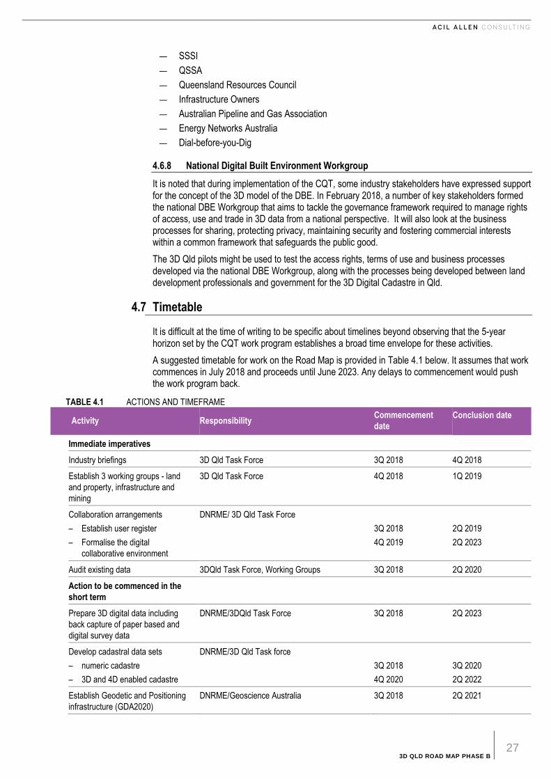
3D QLD ROAD MAP PHASE B 27
— SSSI
— QSSA
— Queensland Resources Council
— Infrastructure Owners
— Australian Pipeline and Gas Association
— Energy Networks Australia
— Dial-before-you-Dig
4.6.8 National Digital Built Environment Workgroup
It is noted that during implementation of the CQT, some industry stakeholders have expressed support for the concept of the 3D model of the DBE. In February 2018, a number of key stakeholders formed the national DBE Workgroup that aims to tackle the governance framework required to manage rights of access, use and trade in 3D data from a national perspective. It will also look at the business processes for sharing, protecting privacy, maintaining security and fostering commercial interests within a common framework that safeguards the public good.
The 3D Qld pilots might be used to test the access rights, terms of use and business processes developed via the national DBE Workgroup, along with the processes being developed between land development professionals and government for the 3D Digital Cadastre in Qld.
4.7 Timetable
It is difficult at the time of writing to be specific about timelines beyond observing that the 5-year horizon set by the CQT work program establishes a broad time envelope for these activities.
A suggested timetable for work on the Road Map is provided in Table 4.1 below. It assumes that work commences in July 2018 and proceeds until June 2023. Any delays to commencement would push the work program back.
TABLE 4.1 ACTIONS AND TIMEFRAME
Activity Responsibility Commencement
date
Conclusion date
Immediate imperatives
Industry briefings 3D Qld Task Force 3Q 2018 4Q 2018
Establish 3 working groups - land
and property, infrastructure and
mining
3D Qld Task Force 4Q 2018 1Q 2019
Collaboration arrangements
– Establish user register
– Formalise the digital
collaborative environment
DNRME/ 3D Qld Task Force
3Q 2018
4Q 2019
2Q 2019
2Q 2023
Audit existing data 3DQld Task Force, Working Groups 3Q 2018 2Q 2020
Action to be commenced in the
short term
Prepare 3D digital data including
back capture of paper based and
digital survey data
DNRME/3DQld Task Force 3Q 2018 2Q 2023
Develop cadastral data sets
– numeric cadastre
– 3D and 4D enabled cadastre
DNRME/3D Qld Task force
3Q 2018
4Q 2020
3Q 2020
2Q 2022
Establish Geodetic and Positioning
infrastructure (GDA2020)
DNRME/Geoscience Australia 3Q 2018 2Q 2021

3D QLD ROAD MAP PHASE B 28
Activity Responsibility Commencement
date
Conclusion date
Develop a new address
management framework and
technology
DNRME/Local Government/#D Qld Task Force 3Q 2018 2Q 2020
Formulate and implement pilot
projects including a proof of concept
project if judged necessary
3D Qld Task Force, Working Groups 3Q 2019 4Q 2021
Longer term actions
State wide implementation of
dynamic datum
DNRME/ICSM 3Q 2021 2Q 2023
Digital lodgement and pre-titles
registration cadastre
– digital lodgement tools and
processes
– pre-titles registration cadastre
DNRME, 3D Qld Task Force
4Q 2019
3Q 2021
2Q 2023
2Q 2023
Develop business intelligence
capability tools
3D Qld Task Force, DNRME 4Q 2019 2Q 2023
Workshops
– Review data audit and discuss
3D Cadastre arrangements
– Integrating DBE models with 3D
Cadastre
3D Qld Task Force
4Q 2020
3Q 2022
1Q 2021
4Q 2022
Training programs
Assessment of training needs in
numeric cadastre processes and
digital lodgement
Conduct training programs according
to needs
3D Qld Task Force, SSSI, SIBA, education
institutions
3Q 2019
3Q 2021
2Q 2020
2Q 2022
Establish platform for RRR 3Q 2022 2Q 2023
Research into capturing BIM models
and development of DBE models
including cyber security
3D Qld Task Force, Working Groups, Industry,
research institutions, CERT Australia
1Q 2021 4Q 2022
Develop business models for DBE
and business intelligence
3D Qld Task Force/ industry 1Q 2023 Ongoing
Note: Initial actions can be commenced prior to Qld Government decision on funding for the CQT. Timing of subsequent actions depends on approval of the CQT
program.
SOURCE: ACIL ALLEN CONSULTING
4.8 Skills and capabilities
The Phase A Report indicated that the skills are generally available in Australia to undertake this project. However, the issues that will arise are multi-disciplinary, likely opening new areas for collaboration. Identifying the skills requirements could be one aim of the pilot projects.
As noted earlier, it is expected that the more widely 3D data and processes come into use, the greater the imperative for organizational training and self-education. Establishing the 3D Cadastre and 3D

3D QLD ROAD MAP PHASE B 29
models of the DBE offers the opportunity to accelerate development of Australia’s skill base in new technology by giving people a reason to upgrade their skills.
SSSI, QSSA, SBQ and AIMS have initiated programs aimed at 3D skill development within the surveying profession. These include accredited training outcomes to be provided via workshops in collaboration with tertiary institutions, technology suppliers and DNRME.
4.9 Anticipated Costs
It is not possible to estimate the cost of the project in its entirety at this stage. The cost to undertake the project can be broken down into several components:
1. Costing of the CQT project is the responsibility of the CQT project team and the DNRME. As such, no estimate of the costs relating to the CQT project have been considered in preparing the Road Map, apart from the costs relating to any joint pilots.
2. The Proof of Concept will entail some cost in specifying and co-ordinating its execution and perhaps out-of-pocket costs for technology providers who provide in-kind funding to create it. Full costing will depend on expressions of interest once the scope has been specified. Total cost may be in the order of $50-100,000 but could be much higher depending on the scope.
3. The Pilot Projects will incur costs as follows:
— costs associated with establishing and paying a small project team to manage the pilot projects
— Costs could in some cases be met by the organizations undertaking the pilots, as they will require the models for their own use in any case.
— There will be additional costs to test hypotheses and methods regarding the creation and use of the 3D Digital Cadastre and models of the DBM. There are several research institutions and private companies that have capability in this area that could be approached via expressions of interest2. Costs will not be known until specific responses to the expressions of interest are received.
— costs will also be incurred in convening a series of workshops – one area would be to review the data audit and the other to discuss issues and options and recommendations for full implementation of the 3D Qld vision.
4. The Steering Committee will be best placed to review issues that arise, formulating solutions and recommendations for governance, legislative and regulatory requirements, protecting access and ownership and providing data security.
This is also likely to require a smaller project team to support the Committee, that might come from within the 3D Taskforce membership or the Consultant.
5. Preparing reports for the Steering Committee on the various matters as per the Road Map
― this will also require input from the project teams created for item 3 above.
It is possible that the cost of the pilots could be as high as $500,000. However, a detailed costing would require more detailed exploration possibly through an open tender or expression-of-interest process.
Other components could be undertaken with funding directly or in kind from the industry players involved on a case by case basis.
4.10 Key Performance Indicators
This Road Map is framed over a 5-year period. Performance would be monitored by the Steering Committee and ultimately the 3D Qld Taskforce.
The CQT will have its own KPIs that have not been included in this the Road Map.
Suggested performance indicators for 3D models of the DBE are set out in Table 4.2 below. This includes the party that is responsible for delivery of the targets.
2 Urban Circus is one example of a company that has the capability for developing 3D city models. Data 61 also has capacity to build such models drawing on its work on the National Map. Bentley Systems is another based on its work in construction and infrastructure.

3D QLD ROAD MAP PHASE B 30
There is potential for slippage in timelines given the parallel nature of the work that is to be undertaken in government and in industry. The program establishes several actions that would be appropriate to monitor throughout the course of the program so that the need for remedial action can be identified and implemented early.
TABLE 4.2 KEY PERFORMANCE INDICATORS FOR 3D MODELS OF THE DBE
Action KPI Responsibility
Industry Briefing Workshop Confirmation of willingness to participate by
industry and local government
Steering Committee
Establish 3 Working Groups Working Groups Established and Chairs
appointed
Steering Committee
Industry Briefings Sign on to the program by all sectors and
evidence of support.
Working Group Chairs
Data audit Clear understanding of data that is
available for inclusion
Steering Committee
Finalise plans for Pilot Projects Agreement on number and arrangements
for Pilot Projects
Steering Committee and Working Group
Chairs
Funding for Pilot Projects and proof of
concept activities
Confirmation of committed funding
arrangements
Steering Committee
Review of timing for Pilot Projects and
adjustments made as required
Confirmation or adjustment to timeline in
the light of evidence
Steering Committee
Report on outcomes from Pilot Projects
including recommendations for
implementation of registries of 3D models
Support for the recommendations across all
sectors
3D Taskforce
Agreement to proceed following
consultations between industry and
government
Formal endorsement of the project by
government and industry
3D Qld Taskforce
Funding Funding arrangements by the parties
confirmed
3D Qld Taskforce
Program implementation Successful launch of the program and
staged delivery as per timeline
3D Qld Taskforce
SOURCE: ACIL ALLEN
4.11 Risk Management
The principal strategy to mitigate project risk is through the development of the proof of concept and pilot projects to demonstrate functionality to potential users as well as government and industry more broadly. This should confirm the benefits that have been identified, as well as exposing the challenges to be addressed. This strategy should also help to broaden engagement in, and support for, the project at the highest levels.
A further risk is the possibility that sufficient funding for the pilot projects is not forthcoming. For this reason, the initial work program includes estimating the cost of the pilot projects and sourcing funding from the parties involved.
A major risk is the possibility that key stakeholders, including the surveying industry, are not persuaded that the 3D Qld vision is worth pursuing, especially the longer-term aspects. If this arises during the briefings or the pilot projects, action will need to be taken to address concerns.
A staged approach, including close cooperation between government and the private sector, under the oversight of the 3D Qld Taskforce, should help to ensure the final implementation meets user needs and is self-funding with managed risks.
A further risk is the emergence of technology problems that cause the Pilot Projects to be stalled resulting in delays to the program and loss of momentum. Close monitoring of the progress of the

3D QLD ROAD MAP PHASE B 31
Pilot Projects by the Working Group Chairs and the Steering Committee will be required to mitigate and manage this risk.
As it will be many years before a fully functioning system is in operation, there is little incentive for organizations to adapt their business systems to operate in the 3D environment. In the absence of a concerted effort to save and hold such data, the risk is that the full benefits of a 3D Qld model could be delayed significantly.
Government support for the 3D Cadastre and 3D models of the DBE as key economic infrastructure will be important to engaging the private sector. Without this support, private sector organizations are unlikely to invest time and resources in addressing the challenges identified by stakeholders, because they cannot capture the common benefits.

3D QLD ROAD MAP PHASE B 32
5 S U M M A R Y A N D R E C O M M E N D A T I O N S
5 Summary and recommendations
5.1 Introduction
The suggested Road Map is set out in Chapter 4 of this report. This chapter summarises critical factors affecting the program and provides recommendations.
5.2 Road Map architecture
5.2.1 Summary of steps as per Road Map to be agreed
3D Qld Overall
1. The Queensland Government and Industry formally endorse 3D Qld Road Map and establish fulltime project team to manage the project.
2. Establish Pilot Projects over time as issues arise.
3. Estimate the cost of the pilot projects, finalise funding estimates and arrange funding.
4. Complete Pilot Projects to identify the technical, process and regulatory challenges.
5. Re-assess the Road Map based on the outcomes of the Pilot Projects(s).
3D Digital Cadastre
Actions that are necessary to enable timely realisation of 3D Qld’s fundamental product (the 3D Digital Cadastre) are being developed by the DNRME under the CQT project. From the perspective of the 3D Qld project the key requirements are:
1. Queensland State Government continue with the CQT project to develop a georeferenced 3D Digital Cadastre and other rights boundaries, and to streamline processes for creating and using the 3D Cadastre, including pilot projects as required.
2. The program to modernise the geodetic datum under the oversight of the Interstate Committee for Surveying and Mapping proceeds to completion by 2023. Adoption of a time-based datum that allows for annual updates of the georeferenced cadastre proceeds after that date.
3. On-going training and development of land development professionals to work with the 3D Cadastre.
Models of the DBE
Actions required include the following:
1. Establish a Proof of Concept to build understanding of the concepts and support across the land surveying sector as well as the planning, design, construction and property sectors more broadly.
2. Estimate the cost of creating the proof of concept, finalise funding estimates and arrange funding.

3D QLD ROAD MAP PHASE B 33
3. Re-assess the Road Map based on the outcomes of the Pilot Projects.
4. Formalise 3D Qld as the collaborative mechanism to develop models of the DBE between all levels of Government, private sector and technology providers.
5. Determine the governance framework, including state/local regulatory framework and the possibility of managing integrated models of the DBE as required.
6. Develop the business model and funding requirements to establish 3D models of the DBE.
7. Establish the arrangements and protocols for development of business intelligence capability and formalise arrangements for managing models of the DBE consistent with the 3D Cadastre.
With a common framework in place, the market can be expected to provide the business processes, software, APIs, secure platform and web services to create and use models of the DBE.
5.3 Potential Longer Term Uses
In parallel, over the longer term, other requirements may include:
1. Local Councils exploring the use of base state imagery and city models as the place holders for the cadastre and other rights boundaries, linked to meta data, for direct input within the models of the DBE by surveyors; with authorisation by the city and DNRME
2. establishment of authorised state imagery and city models (with embedded cadastre, including confidence level) as the sole authorised context for spatially related decisions by the State and each municipality
3. each authority developing processes to create and maintain the authorised models of all government assets and legal boundaries that will form part of the DBE, georeferenced to the global grids
4. development of government processes to use 3D models of the DBE for all spatially related data capture and decision-making at state and local government levels to provide a ‘single point of truth’ upon which other data sets (both public and private) can be overlayed (e.g. health data).
5.4 Technical and Governance/Legislative issues
One of the key goals of the proposed pilot projects is to identify technical and regulatory issues that arise and explore and develop suggested approaches to each issue that is identified.
While it is too early to be specific, it is evident that there will need to be a review of relevant legislation including but not limited to the Survey and Mapping Infrastructure Act 2003 and related regulation. Data that is potentially to be held in models of the DBE could extend beyond that covered in the current Act.
It will be necessary to consider the legislative and or regulatory requirements to protect property rights to the data, establish arrangements for security and access and address the legal arrangements to protect the legal rights of the owners of the data and the property it represents. The newly formed National Digital Build Environment Workgroup, set up to develop the governance framework for the DBE, could provide invaluable support.
5.4.1 Technical
At this stage, there are no specific technical recommendations as it is considered too early to be definitive while the technology itself is evolving rapidly. It is expected that the pilot projects will highlight areas in need of further investigation.
Most of the technical standards are likely to be based on emerging international standards. Australia already has strong representation on many of the relevant work groups including via BuildingSMART and OGC.
5.4.2 Governance/Legislative
The following are just some of the issues that will need to be explored to address the challenges identified by stakeholders:
1. definition of what would comprise an authorised model of the DBE

3D QLD ROAD MAP PHASE B 34
2. establishment of a georeferenced State imagery/model as the official context for state planning, and georeferenced city models as official context for city planning and building approval
― In both cases this would need to include the embedded cadastre (with appropriate meta data to indicate confidence level for both physical and legal attributes) for all legally enforceable decision-making regarding spatially related issues at those scales.
3. establishment of State authorities, each municipality and each utility as the primary registries for their own imagery and models, with allowance for this service to be outsourced to any commercial provider set up to operate under the proposed framework
4. establishment of all private owners as the primary controller of the official model of their property, once lodged with an approved commercial registry
5. definition of the requirements for privately operated registries:
⎯ Privately operated registries will not own the data but hold it in trust for the community.
⎯ They will be required to hold it securely and give access only in accordance with RRR under a new governance framework.
⎯ Data will be held in a distributed fashion that makes it immune to loss, but also only subject to national/state/local law (as appropriate).
6. definition of Authorised Certifiers (e.g. those already approved for various regulations and standards, such as engineers for structure, electrics and fire safety; and surveyors for cadastre, etc.)
7. establishment of requirements for identification of all parties eligible to use 3D models of the DBE
8. Definition of any private model lodged with a registry as the official model such that all decision-making within the federated model becomes legally binding.
― If any parties require more detail in the model or need to have the data recertified to cover the risk of error, it will need to be generated at the time and lodged as an update - so that a binding decision can be made.
It is anticipated that a dedicated project team will need to be appointed to manage this facet of the project, ideally working in cooperation with the national DBE Workgroup
5.5 National Implications
There are national implications flowing from implementation of the Road Map.
The engineering, construction and other industries have emphasised the need for a national approach to any integrated 3D model of the DBE. These industries work across state boundaries. Differences in legislative and regulatory requirements between jurisdictions creates costs and delays for industry.
The Road Map suggested in Chapter 4 has been developed on the assumption that progress would be discussed with other jurisdictions through the ANZLIC forum.
Accordingly, it would be desirable to allow for some flexibility to the Road Map to accommodate national interests should they arise. This could be beneficial to building support in industry and funding for the program of work that will need to be undertaken.
5.6 Implementation Recommendations
It is recommended that the 3D Qld Taskforce:
1. considers this Road Map and after any adjustments required, adopts it to guide the future work program
2. implements the immediate priority actions and prepares for commencement of the short-term actions
3. works with the CQT project team to deliver the 3D Digital Cadastre in line with the CQT project plan and this Road Map
4. uses both Phase A and B Taskforce reports to explore the opportunities for financial and in-kind support for the 3D Qld project, including conducting the proof of concept, pilot projects and outcomes workshop

3D QLD ROAD MAP PHASE B 35
5. implements pilot projects that are of manageable scale (joint government private sector) where concepts can be tested. The lessons would be used to implement change progressively so that stakeholders can see and realise benefits in the short, medium and longer terms
6. establishes a formal project team to undertake a longer-term project to explore and develop a governance framework for 3D models of the DBE using this road map as its starting point.
.

3D QLD ROAD MAP PHASE B 36
R E F E R E N C E S
3D Qld Task Force. (February 2014). Industry Government 3D Qld Strategy. Brisbane: 3D Qld Task Force.
ACIL Allen. (February 2017). 3D Qld road map prelimiary findings. Brisbane: 3D Qld Task Force.
Department of Prime Minister and Cabinet. (2016). Australia's Cyber Security Strategy. Canberra: Commonwealth of Australia.

3D QLD ROAD MAP PHASE B 37
A . W H Y A S H I F T F R O M 2 D T O 3 D
A Why a shift from 2D to 3D
A.1 Why a shift from 2D to 3D?
No two cadastres in the world are alike, but Australia is leading the world in terms of its simplicity, security and quality of Land Administration systems. However, these systems now need to be reformed (to include 3D digital location) to remain world leading enablers for the Australian economy.
The vision for a digital world that replicates physical reality is something within reach of current technology. Enhancements in computing power, geodetic datum (location coordinates) and networked sensors using the Internet of Things (IoT) have made it possible to ‘map the world’ in near real time. By integrating this data with geocentric reference coordinates, the power of location can be related between different sets of data for enhanced relevance for parts of machines, whole pieces of equipment, buildings, precincts, cities, regions, states, countries, even the entire planet.
Our world can become better integrated and digitally represented in 3D, but it needs to be organized and managed in a way that is Authoritative and Secure if it is to be trusted and respected.
A.2 Why is Authoritative 3D and spatial data integration such an important step for this digital future?
1. The world is becoming increasingly complex As policy and economic challenges associated with land development, infrastructure investment, minerals and energy projects and sustainable resource and environmental management grow, governments and industry need the most flexibility and adaptability in the way assets are developed and managed. Improvements in our land or built environment are 3 dimensional (roads, bridges, buildings, mining) as is our natural environment (rivers, vegetation, soils, geology). The legal fabric we use to manage interests in those environments needs to replicate these 3D environments to give the maximum adaptability and flexibility to successfully manage all aspects of our economy with least risk and lowest cost.
Although the legal framework provides for creation of interests in 3D, current methods are based on the use of 2D diagrams which add unnecessary complexity, delay and potential for errors when being interpreted by unskilled people.
2. 3D enhances and improves communication 3D data best replicates what we see every day with our own eyes, so communicating with 3D data is more easily understood because it is more familiar to what we perceive in the physical world. But this is true only if the 3D data are accurate.
3. 3D can be integrated for greater relevance Relevance is the concept of one topic providing context for another topic. Relevance is fundamental to

3D QLD ROAD MAP PHASE B 38
information science and cognitive science which includes geography, humanities, engineering and information technology. Data that can relate to each other are highly sought after as it allows greater
meaning to be derived from the multiple data sources. It is the whole basis for the ‘Big Data’ revolution. Location or spatial dimensions of data (latitude or longitude coordinates and height datum) can provide for integration of 3D data on a global scale, enabling relevant data to be more easily identified and understood.
4. 3D Data Standards enhance functionality When standards are applied to the data capture and management of 3D data it has far greater relevance than it would if was captured and managed without a common standard.
5. It must be Authoritative to be respected Land and property are highly valued assets in the Australian community. For these reasons, property interests are centrally managed via a register under state legislation. Many interests in land are also managed by local government and planning regulations, as well under commercial contracts (such as leases). Decisions pertaining to ownership and use rights, restrictions and responsibilities are often challenged. Any data captured as part of the management of land and property must be properly curated if it is to be legitimate and true. The records must be indefeasible and authoritative.
The 3D Qld Road Map is a pathway to enable a 3D view of our world that creates enhanced relevance between the built, natural and legal environments. The legal environment is the way land is managed via the cadastre, and it is the cadastre that we need to move into a digital 3D, location-based world to have the maximum relevance possible to a 3D Digital world, as well as to enhance on-ground location.
It is important therefore that the cadastre is not only created and recorded accurately, it must be accurately located back on the ground, and in any model used for decision-making. In the latter case, all users need to know that the dimensions and geo-references of all vertices in a model and any embedded boundaries are accurately recorded, and represented at the required scale, if they are to rely on the model for decision-making.

3D QLD ROAD MAP PHASE B B–1
B . L O N G E R T E R M P O S S I B I L I T I E S
B Longer term Possibilities
B.1 Imagining Life in 2040
Imagine 20 years from now (or may be much sooner!) a 3D model of your property has been seamlessly integrated with a Personal Data Locker that contains all verified information about you and your property. The PDL may be held by an authorised registry/node (perhaps linked to a block chain that verifies the sequence of transactions). It means that any needed information can be provided with your authority to financiers, local government, insurers, architects, engineers, builders, asset and facility managers, landscapers, painters and decorators, real estate agents, etc. and in emergencies also to emergency services, health professionals, etc. without your permission, but only to the extent needed to assist you.
Your insurer quotes insurance based on the model. It locks the version of your model that it has quoted, so no change can be made to the model it is insuring. It does not need to keep a copy. It can access the certified locked model immediately - when a claim is made, or when the policy is renewed
Imagine a smouldering fire in your home that sets off an alarm. As soon as it triggers, you and the fire department are alerted. If you are not there, the department is given emergency access to your model and sees that the fire is in your art room where flammable chemicals are stored. They immediately respond. On the way to the fire, using the City model, integrated with the model of your home, the fire team can see your home in its spatial context, seeing access via a rear lane and back gate, and the location of the nearby hydrant, enabling them to plan the response in the few minutes it takes to get there, so that they are able to contain the fire to the back rooms.
After extinguishing the fire, a quick investigation shows it was accidental. They take 3D photos of the scene using their own UAV, uploaded to their own Data Locker (as evidence of how they left the site) together with all required information. They give immediate access to these data to you and you then give access to your insurer. The insurer’s AI compares the before and after 3D models, notes the fire was accidental, is covered under the policy; completes an assessment of the maximum payable based on current buildings costs that are determined from similar recent claims, submits it to an assessor who immediately approves the claim within the limits of the policy.
The money is immediately made available to settle the claim
At the same time, your bot has been searching the net for an architect to design the rebuild. It finds three with time in their schedule to take on the work immediately, who have good reviews, work in the style you like, and are competitively priced. Two are based in other countries and one is interstate.
You select one and time is scheduled by your respective ‘bots’ for a 'face to face' discussion in virtual space.

3D QLD ROAD MAP PHASE B B–2
The calls are made at the appointed time and you show them around your model, including views out the windows and surrounds (based on the models of surrounding homes and the city model in which your home is accurately sited). They can also see the topography and foundations and footings, and all underground services that form part of each utility’s model relating to your site.
While you are discussing what you would like done (not an exact rebuild), they are creating a conceptual design using smart software that integrates seamlessly with your model. You can walk around it virtually, view it from outside, even invite a couple of trusted advisers to look and comment using VR and remote conferencing. At the end of an hour, you are happy with the general concept and appoint the architect, signing a fixed price smart contract that requires payment on approval by your local council.
As the design places the side walls right on the build limit, the architect’s bot searches for a qualified surveyor who can immediately review the model, including its geo-referenced physical dimensions and boundaries (if any are marked), along with the title, to confirm they are accurate within the planning and design limits required.
As your home and site model has not been previously certified, the surveyor is commissioned to do a site survey. They do the survey, capturing some additional detail via LIDAR/photogrammetry for integration into your model, mark the boundaries in the model and attach all meta data required by law to confirm accuracy; certify it, and lock it against change. They also confirm placement of pegs (and pins) in the ground as the guide for the builder.
In future, it will only be necessary for a surveyor to check for changes to the certified model, the title and other relevant documentation, making any resurvey in future much quicker and cheaper if there have been no changes.
With the survey done, the architect spends the next day or so finalising the design (excluding final finishes). All the engineering work is now undertaken by algorithms embedded in the design software that is compliant with the local regulations. In the process, their design software has also polled the local planning, building and related regulations (which are now in digital form and can be understood by the architect’s AI) to check that the design complies (set-back, height, overlooking, run-off, over shadowing, fire, environmental, safety regulations, etc.)
The following day, they invite you to look at their design which, after calling in your friends to review in VR, and with a few tweaks, you approve. Upon your approval, the plan is lodged with the local council, together with the fire report. As the plan complies, it is approved automatically by the council’s AI, and payment to the architect is made immediately from the insurance settlement.
The architect then begins work on the finishes.
In the meantime (day 2 post the fire), your bot has been searching for a local project manager with a good reputation, who is certified, with all appropriate insurances and available to start within two weeks, whose pricing appears competitive. Again, a couple are found. Your bot gives them the approved model to price which they do using their own quantity surveying AI software linked to their own supply base.
Within minutes you get back quotes, subject to variation on final finishes. Your ‘bot’ arranges Mixed Reality (MR) meetings with each project manager in turn. Mixed reality is a combination of the real world and virtual images that appear to be together in the one space. It enables both you and the project manager to see each other, as well as see and discuss the damaged building, the re-build model, and site layout and access – as if you are all together in the one space, although you are not.
Both project managers are offering open contracts for all supplies (where you pay the subcontractors and suppliers directly), with the project manager receiving a fixed fee for the project in stages based on a fixed end date. In the process, the subcontractors have all seen the model and have quoted directly for their services - locking in prices and timing with the head contractor.
After both meetings you call back the first project manager to confirm the principal contract and all sub-contracts.
3D QLD ROAD MAP PHASE B B–3
The project manager has included a work schedule based on the schedules supplied by his subbies, including the subcontractor who will manufacture the main modules off-site (these will be fully fitted with services and only need on-site assembly and connection to services).
Soon, the architect has completed his finishes, and you have selected all fittings from full 3D models (located by your bot on-line), with (perhaps) a shortlist of some products inspected at a local showroom.
Within a few weeks all products have been ordered, delivered and installed in the manufactured modules (with very little waste, no wet weather interruptions, and good quality) and assembled on site, with the whole job finished before most planning permits are now submitted, let alone approved.
As part of the contract, a new 3D model must be created of the 'as built', as it is manufactured, assembled and finished on site. This is done via a combination of LIDAR and photogrammetry by each of the subcontractors as they do their work. Delivery of the models is a condition of payment under their respective contracts, ensuring it is done.
The models also provide proof of work for the subcontractors.
Once the physical job has been completed, the updated models are integrated and made available for the Local Council’s AI to confirm that the as-constructed building is in accord with the design, with the model stored in your Personal Data Locker for future reference.
Your bank and insurer are also all given access to it to affix and lock their certifications that the new building meets all requirements and is in accord with the approved plans. Again, this should be done algorithmically in most cases. As well, all the trade certifications will be linked to the model; with connection data and access to the required parts of the new model being made available to your utilities for their purposes.
In the meantime, you have been searching for new furniture, trying out 3D representations in the new model, seeing how it fits for size and ordering for delivery on the day scheduled for completion. It is also ordered via smart contracts and duly arrives and is paid for instantly, subject to the vendor’s guarantees that you can return it within 30 days if not satisfied.
The operation of the house is also linked into the model via sensors that track energy use and other factors, such as comfort level, lighting and so on.
And so, it goes for all facets of our economy that relate to the design, construction and use of buildings, services, infrastructure and cities.
With costs and time falling dramatically, more and more renovations and re-builds will be done to lift the quality of the whole built environment.
Importantly, once the boundaries are embedded in the city, site, building and infrastructure models; the title, easement, lease and other rights boundaries can be used to limit access use and trade in the models to people with the requisite rights in the real world. This will be especially useful in the case of multi-story buildings with many owners and/or tenants, and where public access is restricted. This is important for security, privacy and commercial reasons
And, then when you sell your building, you will also transfer access rights to its model, enabling the new owner to enjoy the benefits of working in virtual space and mixed reality, without having to recreate and check it all again! Transfer of the property model will also happen automatically upon sale of the property via the Electronic Property Exchange.
Today it is a dream. But who is now brave enough to say it will never happen in the next 20 years?
The key is making the start, to gather and retain the data ready for use when the time comes – building functionality as we go through the use of API’s, rather than a large central ‘program’.

3D QLD ROAD MAP PHASE B C–1
C . T A S K F O R C E A N D C O N U L T I N G T E A M
C Taskforce and conulting team
C.1 Taskforce members
— Peter Sippel (Chair), Representative Surveyors Board of Queensland
— Steve Jacoby, Executive Director - Land & Spatial Information - Queensland Department of Natural Resources & Mines. Chair of the Queensland Spatial Information Council, Queensland's representative on ANZLIC - the Spatial Information Council, as well as a member of the CRC for Spatial Information board, and a member of 2026 Spatial Industry Transformation and Growth Agenda and 3D Qld Taskforce
— Elizabeth Dann, Registrar of Titles, Queensland Department of Natural Resources & Mines
— Russell Priebbenow, Director of Surveys, Queensland Department of Natural Resources & Mines. Queensland’s representative on the Intergovernmental Committee for Surveying and Mapping – ICSM and a member of the Surveyors Board of Queensland
— Lee Hellen, Representative Spatial Industry Business Association and Spatial Innovation Foundation
— Ken Cross, Representative Australian Institute of Mine Surveyors
— Richard Statham, Senior Surveyor - Advising Registrar of Titles
— Chris Swane, Land Survey Commission, Surveying Spatial Sciences Institute
— Alasdair Begley, Representative Queensland Spatial & Surveying Association
C.2 Consulting team
— Alan Smart, principal ACIL Allen Consulting expert in the valuation of spatial data infrastructure and services, and Lead Consultant for this project.
— Michael Haines, Lead Author of this Report and CEO of VANZI working with stakeholders to articulate a vision for an integrated 3D DBE including all RRR, for use in decision making throughout the property cycle. Michael assembled the Consulting Team.
— George Havakis, Managing Director of GISSA International specialising in Information Management and Technology where he combines project management experience with specific knowledge of the intricacies and dependencies of GIS projects
— Haydn Read, NZ based consultant who has been leading the use of 3D data across the NZ government and local councils by identifying the key value propositions.
— Peter Murphy, Director Brazzier Motti, which provides consulting services in survey, project management, mapping and GIS.

3D QLD ROAD MAP PHASE B C–2
— Prof, Abbas Rajabifard, Director of the Centre for Spatial Data Infrastructures and Land Administration at the Department of Infrastructure Engineering, the University of Melbourne. Prof. Rajabifard is a global authority on the integration of 3D cadastral data with GIS and BIM models.
— Alan Hobson, consultant with expertise in Building Information Modelling and its application to Surveying and Deputy Chair for the Spatial Information and Cartography Commission of the Surveying and Spatial Sciences Institute (SSSI)
Jim Plume, member of the Infrastructure Committee for buildingSMART International, contributing to the development of international standards for information modelling of the built environment, with a specific focus on Precinct Information Modelling.

ACIL ALLEN CONSULTING PTY LTD
ABN 68 102 652 148
ACILALLEN.COM.AU
ABOUT ACIL ALLEN CONSULTING
ACIL ALLEN CONSULTING IS THE
LARGEST INDEPENDENT,
AUSTRALIAN OWNED ECONOMIC
AND PUBLIC POLICY CONSULTANCY.
WE SPECIALISE IN THE USE OF
APPLIED ECONOMICS AND
ECONOMETRICS WITH EMPHASIS ON
THE ANALYSIS, DEVELOPMENT AND
EVALUATION OF POLICY, STRATEGY
AND PROGRAMS.
OUR REPUTATION FOR QUALITY
RESEARCH, CREDIBLE ANALYSIS
AND INNOVATIVE ADVICE HAS BEEN
DEVELOPED OVER A PERIOD OF
MORE THAN THIRTY YEARS.