Embed Size (px)
Citation preview
R E P O R T
O F THE
O F THE
O F THE
C I T Y O F NEW Y O R K ,
In conformity with an Act of the Legislature passed May 11,1869, and an Aet passed May 19, 1870,
RELATING TO
IMPIZOVEMENTS OF PORTIONS OF THE COUNTIES OF WESTCHESTER AND NEW YORK, THE IMPROVEDIENT OF SPUYTEN DUYVIL CREEK
AND HARLEM RIVEIt, AND TO FACILITIES OF COMMU- NICATION BETWEEN SAID COUNTIES.
ALBANY : T H E A R G U S C O M P A N Y , P R I N T E R S .
1871.
R E P O R T .
Under an act entitled " An act for the improvement of certain parts of Westchester county, Harlem river and Spuyten Duyvil creek," passed May 11, 1869, and "An act," in part amendatory thereof, "to provide a plan for the improvement of portions of the counties of Westchester and New York, and to provide facilities of communication between said counties, " passed May 19, 1870, the board of colnmissioners of the department of public works of the city of New York respectfully submit the following
REPORT :
The powers and duties conferred upon the depart- ment by the foregoing acts, briefly stated, apply :
3'irst. To "that part of the county of Westchester lying west of the New York, Harlem arid Albany railroad, south of the southerly line of the village of Yonkers, and a line in continuation thereof," for the purpose of devising and preparing'maps, plans and profiles showing such changes and improvements a,s may be made in existing streets, avenues and roads within such area, with benefit to the property affected,
4 REPORT OF THE BOAED OF CONMISSIONERS
and to the public interest, and for establishing the loca- tion of such streets, avenues, roads and public squares and places, as may be laid out or discontinued with like benefit; to plans for the proper sewerage and drainage of the land within the said area, and for the supply of pure and wholesome water therefor.
Second. To the Harlem river and Spuyten Duyvil creek, with reference to plans for the improvemvnt of the same, and to plans and locations of all bridges, tunnels and other means of transit across or under said river and creek, and to the building or constructing of any and all such bridges, tunnels, etc.
Third. To the proper proceedings on the part of the department, in reference to obtaining the moneys necessary to be raised by the counties of New York and Westchester, respectively, to carry out the pro- visions of the said acts.
CONDITION O F THE WORK, APRIL 2c"l'~, 1870.
Taking u p the work at the date that it officially devolved upon this department, on the twentietll day of April last, it was found, with reference to the duties pertaining to Westchester county, that preli- minary topographical surveys and maps had been made, under contracts with surveyors, of portions of the towns of West Farms and Yonkers, lying adjacent to Spuyten Duyvil creek and Harlem river, covering, in all, about 2,000 acres, and being about one-fourth of the whole area embraced in the acts.
The contracts embraced about 1,000 acres in addition to the parts surveyed and mapped, upon which the
surveyors were then engaged. The work under these contracts had been in progress since about 1st August, 1869. The maps, or separate sheets of surveys, that had been made and returned by the different surveyors, had not been collated and reduced to working form, and the general scope of the work was not sufficient to enable the department to proceed intelligently in the study of tlie improvc~ments contemplated in con- nection with those in progress adjacent in the city of New York, until the surveys were extended to a t least the limits prescribed in the contracts.
The department also found that the work of laying out streets, roads and avenues in the town of Morri- sania, by com~nissioners appointed under an act of the Legislature, passed May 19, 1868, was not completed in that part of the town "lying west of the New York, ade ern and Albany railroad,, and bordering on the Harlem river ; and the investigations relating
to that district could not appropriately be proceeded with until the Morrisania commissioners had finally closed the duties assigned to them.
I11 regard to improvements of the Harlem river and Spupten Duyvil creek, and the crossings of their channels by bridges, or tunnels, no progress had been made in the field work, hydrography, boring, and other investigations necessary to the preparation of
proper plans. Under an act of the Legislation, passed April 24,
1867, bulk-head lines were laid down on both sides of Spuyten Duyvil creek and Harlem river, from the Hudson river to Third avenue, and such lines were
approved by a subsequent act, passed April 22, 1868, but with a provision which authorizes this department, if it deem it necessary for the public interests, to alter and amend any part or parts of such bulk-bead lines. As the bulk-head lines were laid down anterior to the passage of the act providing for the improvements of Harlem river and Spuyten Duyvil creek, and the location of bridges, tunnels, and other means of transit across or under the same, it is not improbable
that some inodification may become necessary when the sub,ject is fully examined in connection with such later conteinplated improvements. This will be deter- mined, as early as practicable, in the progress of the several works.
"An act to incorporate the Hudson and Harlem River Canal Con~pany," was passed May 2d, 1863 (chap. 365), which conferred upon the canal company authority for " constructing, maintaining, managing and operating a canal, with all the necessary or proper basins, docks, wharves, piers, bulk-heads, or other works, or appendages connected therewith, commenc- ing at the bulk-head line of the Hudson river, as located by the harbor comn~issioners, at the mouth of the Spuyten Duyvil, and thence to the draw, or swing- bridge of the IIudson River railroad; thence along such line or route, as the directors may deem proper, to the bulk-head on the Harlem river, as located by the harbor commissioners, subject to the modifications
as provided in section eight of this act." The modi- fications of section eight relate to the filing of maps, and to proceedings preliminary to locating the route.
The company were authorized to construct a canal, or slack-water navigation, of not "less than sixty feet
water surface, or width, nor less than seven feet in depth of water at low water." "To deepen the channel of either of the said rivers, whenever, in the opinion of the directors, the interests of the company will be advanced thereby." "To collect tolls, dockage, wharfage and basin charges upon all craft navigat- ing the proposed canal, or occupying basins, docks, wharves, slips, piers, or other works, or grounds of the said company." To acquire title to "any land
belonging to the county, city or town," or individuals, through petitions to the supreme court for commis- sioners of appraisal, etc. ; hut "when said canal shall cross any public street, avenue, road or highway, the company sliall not be required to make compen- sation for the land so taken of the public street, avenue, road or highway ; but, by suitable bridges, restore it to such a state as not to impair its useful- ness ; and in the construction of such bridges, they shall not be required to erect any better bridge than the bridge over Harlem river at McComb7s dam ;" and other extended and liberal powers were conferred upon the company.
The time limited by the act for the conipletion of tlie work was five years.
An amendatory act, passed April 21st, 1864 (chap. 268), made it lawful for the directors of the canal company "to extend their canal from such point on
the Harlem river, south-easterly of the Harlem bridge, to such point on Long Island sound, and along such
line between such points as they may deem proper," etc.
Another aliiendatory act, passed April 4th, 1866, extended tlie time for the colnpletion of the work "three years, in addition to the time provided in the twentieth section of an act entitled 'An act to incor- porate the Hudson and Harlem River Canal Company, passed May 2, 1863.' " This applied also to the amendments passed April 21st, 1864.
No work of actual construction has been done. e
These are the principal features of the acts that have s more particular bearing upon "the improve- ment of Harlem river and Spuyten Duyvil creek, and the plan and location of all bridges, tunnels and
other means of transit across or under said river and creek," which have been referred to this depart- ment.
Tlie department also found the Spuyten Duyvil and Port Morris railroad located from its point of con- nection with the Hudson River railroad, at Spuyten Duyvil station, along Spuyten Duyvil creek and the Harlem river to tlie New Pork, Harlem and Albany rail- . ,
road, in Morrisania, and the work of construction in progress.
That portion of the route, together with a profile of the same, crossing or touching upon an extreme north- ern point of the county of New York, near the north shore of Spuyten Duyvil creek, was approved by the board of comnlissioiiers of the Central park, September 7, 1869, and on April 16, 1870, tlie following resolution was passed by the said board :
Resolned, That under and by authority of chapter 826 of the Laws of the State of New York, passed May 11,
1869, this board concur with the proper officer, or board in authority, in authorizing the improvement known as the Spnyten Duyvil and Port Morris railroad.
The map and profile of the located line is understood to have been filed according to law ; a copy of the same, from Spuyten Duyvil to the New York, Harlem and Albany railroad, was received from Messrs. Strong and Shepard, attorneys for the railroad company, on the 10th day of February.
The act of incorporation entitled " An act to construct a railroad from Hudson River railroad at Spuyten Duy- vil to the East river at Port Morris," passed April 24,
1867, authorizes Gouverneur Morris, Wm. B. Ogden and other persons named, and their associates, to form a corporation under the provisions of the general railroad act, for the purpose of constructing a railroad, with single or double track, etc. ; "the road to be constructed across the island of New York in such manner as not to interfere with the present location of the Harlem River canal, and upon a line to be approved by the board of commissioners of the Central park, but in no case to be located south of a direct line in continuation of Inwood street to the Harlem river."
In all cases where the right of way is donated for the road along the Harlem river they shall construct side or spur tracks to any dock, pier or wharf, built on the remainder of such land, at the request of the donator of said right of way, his heirs or assigns ; provided the said branch tracks shall not be called for oftener than once
on 200 feet, nor exceed 1,000 feet in lengtli in the aggre- gate, and receive and deliver freight to and from said track. "
This work, and that of the H~ldson and Harlem river
canal, from thcir peculiar and solnewhat circulnscribed position, will have, if carried out in accordance with all the existing provisions of tlie several acts, relations
of a varied and important charactcr with the works that have beell intrusted to the department in the vicinity of the Harlem river and Spuyten Duyvil creek. The subject is referred to here for tlrat reason, and will be further remarked upon before closing this report.
Requisitions had been made by the board of com- missioners of the Central park upon the treasurer of .d
Westchester county for the sum of $20,000, to defray I
the expenses of surveys, $6,000 of which had been
received. The sum of $5,980.42 had been expended for surveys. The total amount of the contracts entered
into was upward of $29,000, being $9,000 over the amount of the requisitions.
PROCEEDINGS O F THE DEPARTMENT O F PUBZIC PARKS.
Pending the extension of the surveys in Westchester . Y
county and the closing of the duties of the Morrisania commissioners, the department, after having caused the
maps, as far as returned by the several surveyors, to be collated and arranged in convenient form, in con- nection with the map of the northern part of the city, and having taken a general view of the extent and character of the work intrusted to it, the important interests involved, the scientific questions tliat must .
O F THE DEPARTMENT O F PUBLIC PARKS. 11
naturally arise, and the practical skill and experience required in the successful treatment of the subject, placed the work, in September last, in charge of a bureau of topographical and civil engineering, to which was also consigned the connected and similar improve- ments of tlie northern and eastern portions of the city of New Pork within the jurisdiction of the depart- ment ; the bureau having been organized for these special objects.
The surveys under contract in Westchester county were mainly completed in October last, when additional contracts were made, upon somewhat more favorable terms, both as to the cost and the character of the service to be performed, than those of the previous ones, for surveying and mapping the balance of the
9
district, comprised in the acts of the Legislature (exclu- sive of Morrisania), being about 4,500 acres. (A synopsis of the contracts is appended to this report.)
Surveys and maps of about 1,500 acres are under- stood to be nearly completed u p to this date, under the new contracts, and the several parties are dili- gently prosecuting the work. A field party has been employed by the bureau since the middle of Novem- ber last, principally in advancing such work as could be advantageously done in connection with the im- provement of Harlem river, and the determination of the sites of crossing of the channel during the imper-
fect condition of the surveys, and the incomplete 8
topographical development of the district north and east of the Harlem river. An accurate base of levels has been established along the Spuyten Duyvil creek
and Harlem river, between the Hudsoii and East rivers, froin which to determine the character of the tides and tidal currents hereafter, by means of a series of obser- vations to be obtained by self-registering tide gauges, and also to serve as a proper datum, or plaiis of reference, for all works that may have direct relation to the tide level.
A site for a suspension bridge over the Harlem river has been partially developed within the limits "north of tlie bridge known as the High bridge, but not more than half a mile therefrom," as prescribed by the act of 1870. Although the examinations ase not complete, no doubt is entertained of the practica- bility of the site for the location and erection of a stable structure, that will afford a convenient commu- nication between Tenth avenue, on the New York side and a suitable avpnue or road on the Westchester side of the river.
Some investigations have been made in regard to the water supply of the Westchester district, and a communication upon that subject, from the engineer in charge of the bureau, is appended to this report.
A copy of the final map prepared by the Morrisa- nia commissioners, of that part of the town " lying west of the New York, Harlem and Albany railroad," and bordering on the Harlem river, was procured on the seventh of January (the map having been com- pleted by the commissioners on the sixth), and such general examination of the questions connected with that district has since been made, as the unfavorable
season of the year would permit. Early in the ensu-
ing season it is expected that the whole subject will
be opened t o such an extent, by the maturing of sur- veys and plans, as to enable substantial progress to be made by the department in the execution of the responsible trusts committed to it ; and, it may be added, that the department could have made greater progress in some portions of the work during the past year, had funds been a t its disposal to defray the necessary expenses.
As before mentioned, it was found by the commis- sioners of the department, a t the date of entering upon their duties, that obligations had been entered into for surveys to tlie amount of $9,000 over the amount of requisitions made upon Westchester county; and no additional requisition could be made, the avails of which would be receivable before the
fore part of the following year. By section four of the act of 1870, the supervisor of the town of West Farms was "authorized and directed to borrow upon the credit of said town, such sum of money, not exceeding $10,000, as may be necessary to pay expenses as already incurred," etc.
The department notified the supervisor, on the '7th day of June last, of the amount of expenses to be thus provided for, and in November following certifi- cates of indebtedness, issued by the supervisor and town clerk of West Farms, to the amount of $9,355.10 were received.
On the 23d day of November the department made a requisition upon the treasurer of Westchester county for $40,000, to cover all arrears, and to apply to snr-
veys under the new contracts, and to other expenses chargeable to Westchestel* county for the ensuing year. The avails of tliis requisition will be reduced by the amount of the certificates of indebtedness, issued by West Farms as above mentioned.
The new contracts for surveys and maps contain the necessary provisirons, that the surveyors shall receive their compensation only from funds provided by the supervisor of Westchester county, pursuant to the acts of the Legislature, when funds so provided are in the possession of the department.
The department received, May 25, 1870, from the town of Yonkers. ............................................... $10,000
And July 23, from tlle town of West Farms. ................. 5,000
Making ............................................... $15,000 --
being the balance due on the original requisitions for $20,000.
SUGGESTIONS AS TO AMENDMENTS OF THE ACTS OF
1869, 1870, AND OTHER REMARKS.
With the foregoing statement of its proceedings and of the condition of the work committed to it, the department' respectfully submits to your honorable
body the following suggestions as to amendments of the acts of 1869 and 1870, together with some remarks upon other matters relating to the successful dis- charge of the duties conferred upon it, which seem to be proper subjects of legislation.
The act of 1869 provided that the autliority "under this act shall expire on the first day of January,
which will be in the year one thousand eight hun- dred and seventy-one."
This autliority embraced chiefly the range of duties herein before quoted, except those relat,ing to the actual construction of the works to be planned. The progress made under tliat act, u p to the time that the duties devolved upon the department, and since that date, has already been stated. The act of 1870 extended tlie duties, and provided that "the said department shall prepare and file, as herein after directed, the maps, plans and profiles authorized by the said chapter" (826 of act of 1869), "within one year from and after the passage of this act," etc. The act having been passed May 19, 1870, the limi- tation of time for the performance of the duties is May 19, 1871, being an extension of time over the previous act of less than four months.
The territory embraced in the acts covers about 8,400 acres, equal to more than one-half the area of
New York island, and is greatly diversified by hills and valleys, rugged, precipitous and rocky surfaces, wooded and open land, streams, roads, etc., and is bounded, to a large extent, by navigable waters and the city of New York, and connected with improve- ments, existing and contemplated, of great extent and importance. It is obvious, from the character of the
A work and its diverse relations, that the time is much too limited for the department to give to it the proper attention it demands. It would be barely practicable, with all the necessary funds provided, to perform the prelinlinary work required for an intelligent corn-
prehension of the subject within the brief period prescribed.
As bearing upon this point, it may be stated that the laying out of the portion of the city of New York north of One Hundred and Fifty-fifth street has been in the hands of two different commissions about ten years, and the unfinished work is now being com- pleted by this department. The area of ground con- tains about 2,000 acres, or about one-fourth of that of the TTestchester district. The laying out of the por- tion of the town of Morrisania, recently completed, exclusive of plans for sewerage and drainage, embrac- ing 2,700 acres, has required over two and a half years. The surveys of the portion of New York island north of Eighth street, and the laying out of the city above that point to One Hundred and Fifty- fifth street, embracing in all about 10,000 acres, was the work of commissions and surveyors at different periods for at least seven years. The surveys and
plans of the Central park were in hand by different persons, previous to and during the work of construc- tion, at least six years before the plan was matured as finally carried out. The area of the park is 843
acres. The department, in view of the time limited by the
act, has been disposed to make all the progress that was prudently practicable, being duly impressed with the great importttnce to the city of New York and the county of Westchester, and all the public interests involved, of maturing the improvements contemplated at an early day ; but its experience, since entering
OF THE DEPART~~.IEA-T OF P UBLIC PARKS. 1 7
upon the duty, has convinced it not only of the inadequacy of the time, but that it is unwise to press with undue haste duties of this nature. It therefore suggests the extension of time to such period as your honorable body may deem reasonable and proper.
The act of 1869 defines the boundaries of the West- Chester district, on all but tlie westerly side, by purely arbitrary or artificial lines. The westerly side rests upon the Hudson river, Spuyten Duyvil creek and the Harlem ,river ; while the northerly side is formed by a line, crossing ranges of hills and valleys nearly at right angles with it, and the easterly line (which closes the triangular figure of the district) is the New York, Harlem and Albany railroad, running through the valley of the Bronx river, and on alternate sides of that stream. The latter boundary, especially, is one that it is foreseen will lead to some embarrass- ment on the part of the department in the practical treatment of a considerable portion of the district bor- dering upon it. The difficulties apprehended cannot be specifically known or pointed out until the work is somewhat further advanced ; but a glance at the nlap of the southern portion of Westchester county, with a consideration of the topographical and geo- graphical features of that section, will indicate their general character. It will be seen that the valley of the Bronx, through which the New York, Harlem and Albany railroad runs, is the principal depression extending in a northerly and southerly direction between the Hudson river and Long Island sound, and receives and discharges the common drainage of
2
broad belts of territory lying upon either side. The drainage from the westerly side obviously cannot be separated in any plans for its future discharge, from that received from the easterly side, and a mutual and common system of sewerage or outflow must therefore
be devised and adopted, whenever any other than the present natural means of discharge shall become neces- sary.
Such a system should be had in vie%-, if not fully perfected, in maturing the general design for the treatment of the westerly slope of the valley, and the system cannot be int,elligently investigated while a large portion of the territory, which should influence its arrangement, is detached and excluded from the field of operations with the purview of the depart- ment.
With regard to the location of streets, avenues and roads to be established on the westerly slope of the Bronx valley, similar difficulties arise. A compre- hensive and j~idicious arrangement of such improve- ments should have reference as well to the interests and conveniences, present and remote, of the popula- tion occupying the easterly side of the valley, as to that occupying the westerly side; the interests are, in reality, so nearly identical and blended as to render
the consideration of any line of demarcation drawn between them very difficult, if not impossible. The valley is naturally marked out as the site of one of
the chief inland thoroughfares converging upon the city of New York, from the north and east; and as such thoroughfare it must have, in corresponding
proportions and importance, lateral connections and tributaries, entering and intersecting it from both sides in well considered relations of adaptability and
fitness to each other and to a harmonious connection with the more remote improvements in a general plan. The importance of the connecting parts increases as they approach the city and spread out in the direc- tion of the navigable waters of Long Island sound on the one hand and of tlie Hudson and Harlem rivers on the other, and becomes more closely interwoven with the complex interests of a thronged and busy commercial mart, rendering thereby the necessity more imperative of giving to them that comprehensive con-
sideration which will best adapt them to all exigen- cies that may be reasonably foreseen. Such consider- ation cannot well be given them without overstepping the boundary line and making examinations of the territory beyond, similar to those instituted in the opposite district, for which no provision has been made in the law.
Again, in providing a plan for the supply of pure and wholesome water to the Westchester district, as a t present bounded, difliculties of nearly the same nature are met with. The common interests of this district and of that lying to the east of it, in a gene- ral supply of water that must be derived from a com- mon source, are apparent, and indicate the propriety and economy of conducting the necessary examina- tions with a view, if not to the general application of the plan to be matured, at least with a careful regard to the prospective necessities of the eastern district.
This subject has been considered in the annexed com- munication from the engineer in charge, and need not be further referred to here.
Many instances could be cited illustrating the dis- advantages and inconveniences arising from the sud- den and abrupt terniination of public improvements upon a purely arbitrary line, without reference to future development, spread of population, and neces- sities to grow u p beyond; but it is believed that suf- ficient indication has been given of the difficulties of the case in question.
It would seem, from the present acquaintance of the department with the subject, that it must either treat a considerable portion of the eastern border of the territory committed to it, provisionally, as regards the improvements they may recommend, or assume, to some limited extent, from such knowledge as they
can obtain without incurring expense, by surveys, or otherwise, certain plans to be hereafter carried out in the section of country beyond, in connection with the authorized improvements. Either course would be objectionable, imperfect in its results, and not in con- formity with the apparent objects of the law.
Without suggesting any specific action in the mat- ter, the department, with these remarks, leaves the subject relating to the eastern boundary to your honorable body for consideration and disposal.
I n regard to plans for water supply for the district, as bounded by the act of 1869, section one of that act provides for the necessary surveys within the district for the purpose of devising and preparing maps, plans
and profiles, embracing and showing such changes in the location, width, courses, windings and grades of the streets, avenues and roads now laid out within the area above described, as in their opinion can be made with benefit to the property affected, and to the pub- lic interest ; and also, the location, width, courses, windings and grades of such streets, avenues, roads and public squares and places, as in their opinion can be laid out, or discontinued with like benefit, "inclu- ding plans for the proper sewerage and drainage of the land within said area and for the supply of pure and wliolesome water therefor," etc.; but no express authority is given .for s u r v e y s and e x a m i n a t i o n s t o be
m a d e outside' of t h e d i s t r i c t w i t h reference t o t h e
w a t e ~ s u p p l y . To enable proper plans to be matured such authority is necessary, together with a provision for defraying the appropriate expenses.
The district must be supplied with water from exte- rior sources, and these sources must be examined and determined by proper and careful investigation. To give entire efficacy to the proceedings of the depart- ment, under the law, some provision would seem necessary in regard to jurisdiction over such exterior drainage district, or water shed, streams, etc., as may be found upon investigation to be requisite to furnish the needed supply of water. It would not be advisa- ble to incur much expense in examinations and plans without such provisions, as the labor might otherwise be lost, or inure to the benefit of wholly exterior interests.
As the law now stands, the department has no
* authority or powers to enable it to perfect and con- trol a plan such as seenis to have been contemplated.
The Hudson and Harlem River canal, and the Spuyten Duyvil and Port Morris railroad have been alluded to, for the purpose of calling attention to some features of those works, and of the acts under which their construction is authorized, which, it is
apprehended, may have an undesirable influence upon the plans to be prepared by this department and
upon the processes to be adopted in carrying out such plans in the vicinity of Spuyten Duyvil creek and the Harlem river.
By reference to the provisions of the canal act which have been quoted, it will be seen, from their general
terms, that such construction may be given to tliem as would be liable to embarrass the carrying out of a general plan of improvement of Spuyten Duyvil
creek and the Harlem river, and plans for approach- ing and crossing their channels by bridges or tunnels, as contemplated in the acts of 1869 and 1870.
In order to meet successively the engineering diffi- culties that are liable to be presented in the execution of such plans, free control should be had of surround- ing space, both of land and water, of the channel and bed of the streams, and of the flow or stoppage of the tide and tidal currents, and various processes, expedients and precautions pertaining to submerged and hydraulic operations must be resorted to and much labor and expense incurred, which should not be trammeled by any restrictions or obstacles that it
. . may be practicable to avoid.
A
Should the canal works be carried forward during the execution of the plans of the department, it is not seen how some of these inconveniences can, with entire certainty, be avoided.
The canal act having passed several years before the act relating to the latter improvement, it is pre- sumable that- the provisions of the act of incorpora- tion were less clearly defined than they would have been had these improvements then been under con-
C \ sideration.
By reference to the map accompanying this report, it will be seen that the Spuyten Duyvil and Port Morris railroad, as located and concurred in by the late board of conlmissioners of the Central park, and now under construction, occupies, or runs in close proximity with public roads for considerable distances in the vicinity of the Spuyten Duyvil creek, and intersects and crosses other roads and avenues that are much traveled, and which are destined soon to become of much greater importance in connection with the improvements in that vicinity that have been intrusted to this department to design and execute. Similar conditions exist in regard to other roads along the route south of Spuyten Duyvil and Kings- bridge, communicating with the city of New York, and giving access to wharves on the Harlem river. The route also, for a considerable portion of the dis- tance, lies immediately along or in close proximity with the bulk-head lines that have been laid down on the Westchester side of Spuyten Duyvil creek and Harlem river. The grade of the road, as represented
b y the profile accompanying the map of location, is generally five feet above high water mark. Tliis necessitates, in the case of most of the roads men- tioned, immediate contact with them, or rail crossings on the surface of the roads. The same difficulty would occur, to what extent cannot now be determined, as to
roads and avenues to be hereafter laid out, together
with the crossings of the rivers and approaches to the crossings, by this department. If, under the act
of incorporation, branch tracks should be laid down i
from the main line to numerous wharves along the rivers, and cars run upon them, these difficulties will be much augmented.
The road is destined to be one of importance in the amount of basiness transacted upon it, and the numerous trains to be run over it, and especially rapid passenger trains. The general result to be "
apprehended from the road thus situated and ope- rated, and one upon which much public anxiety is
being expressed, is, that it must exercise an unfavor- able influence upon neighboring property, and cause much insecurity to communications in its vicinity, and between Westchester county and the city of New York, until the difficulties are properly provided for. Such communications a s it may beconie practicable hereafter to establish, by means of suspension bridges and tunnels over or under the rivers and roads in
tlieir vicinity, will partially meet the questions of convenielice and safety, but much of the d S c u l t y will remain to be guarded against by other means. The department can now only foresee, that, a s regards
the works committed to them to devise, they must resort to some modes and plans of arrangement in connection with the subject that it would be desira- ble, on the ground of expense, convenience and the public interest generally to avoid.
In this connection the department would call the attention of your honorable body to the question of railroad lines and coiinectioiis generally, in the Westchester district, and would suggest the consider- ation of the subject of establishing and defining the principal railroad routes to be hereafter occupied throughout that district. By so doing it is believed much future embarrassment miglit be avoided, time would be saved, and the facilities enhanced for tthe early prosecution of such improvements.
The questions of crossings, intersections and grades, affecting the safety of the public and the property interests of the district, could be at least measurably settled so as to prevent the recurrence at a future day, when population and improvements have thick- ened, of those difficult problems that perplex and retard railway movement in connection with cities that have grown up without preparing for such emergencies.
The construction of railway lines of transit extend- ing northwardly and eastwardly from the city of New York, in connection with similar lines extending through the city and the crossings of the Harlem river, is a subject that has for several years received much consideration, and the department is desirous of anticipating, so far as a reasonable foresight may do
so, the questions which may arise in regard to such
improvements to the extent that they apply to tile discharge of its duties in the district assigiied to them, "with benefit to the property affected, and to the public interest."
PETER B. SWEENY,
President o f the Department qr Parks of the City of New I'brk.
CITY OB NEW YORK, DEPARTMENT OF PUBLIC PARKS, 265 BROADWAY, March 21, 1871.
COMMUNICATION
ON THE SUBJECT O F WATER SUPPLY.
CITY O F NEW YORK:
Decenzber15,1870. 1 Hon. PETER B. SWEENY,
President of Department Public Parks :
SIR. -I mentioned in my communication of October 8th that examinations had been made of the principal
streams in the southerly part of Westchester county, for the purpose of ascertaining the amount of water they would furnish, and that I would report the results as soon as a statement could be prepared. I submit, now, the following statement' :
By the act of May l l th , 1869 (chap. 826), and the subsequent act of May 19th, 1870 (chap. 797), it is made one of the duties of the department to devise and prepare plans for the supply of pure and whole- some water for " that part of the county of Westches- ter lying west of the New York, Harlem and Albany railroad, and south of the southerly line of the vil- lage of Yonkers, and a line in continuation thereof."
The authority conferred is broad and general ; no intimation being given as to sources of water supply to be sought, or as to the consideration of questions that might arise affecting the supply to districts out-
side of that referred to. A reasonable construction would seem to be, that local sources should first be sought, and if these proved insufficient, then to seek more distant ones ; and, also, that the natural and necessary supply of other districts sllould not be impaired, so far as it is practicable to determine the characteristics, extent of supply, etc., present and prospective, of such districts.
The examinations I have made up to this time, are not safficieiit to enable me to mature a definite plan, and I report now only the facts that have been obtained, together with some general conclusions upon the subject.
On the 30tli September, and 7th and 8th October
last, after a long continued drought of the season, anticipating that the fall rains would soon set in, 1 had the following streams gauged, to determine the amount of water furnished by them at their lowest stages, viz. :
Nepperlian (or Saw-mill) river. Sprain brook. Grassy Sprain brook. Bronx river and Hutchinson river. The points at which the streams were gauged are
generally a little north of the latitude of the village of Yonkers. The aggregate amount of water was found to be 4,825,440 gallons passing in twenty-four hours. The drainage area, from which this flows, is about sixteen miles in length from north to south, by an average width of three and three-fourths miles, and contains about sixty square miles.
The quantity of water furnished in proportion to
the area of the water-shed is very small, owing to the extreme drought that had prevailed for several months previous to the gauging.
The drought during the summer months of this year and last year, has been very unusual, and has afforded an opportunity of obtaining important mini-
rrlurn results of water supply. The amount of rain fall, as registered at the observatory in Central park
for the months of July, August and September last,
was . . . . . . . . . . . . . . . . . . . . . . . . . . . . . . . . . . . . 9.39inches. And for the same months in 1869 . . . . . . 7.72 "
Against tlie same months in 1868. . . . . . . 22.78 "
And for the same months in 1867 . . . . . . 12.67 " The mean rain-fall during the same months, for a
period of thirty-two years, previous to 1858, was, as recorded at Brooklyn Heights, by the late Meriam,
11.16 inches. This shows the comparative low rate of rain-fall dur-
ing those months, for this year and the last ; and it
inay be inferred from tlie data, that the quantity of water gauged of 4,825,440 gallons in twenty-four hours, is a safe minimum for an estimate. The drainage area furnishing this quantity is, as before stated, sixty
square miles, and applying the proportion to the more easterly part of Westchester county, which contains several available streams that have not been gauged, the drainage area of which is estimated at twenty-five
square miles, gives ihr the latter area 2,010,600 gallons in twenty-four hours ; or, for the entire available
drainage area of eighty-five square miles, 6,836,040
gallons in twenty-four hours. I do not assume that any water could be taken from beyond the limits of Westchester (in the State of Connecticut), although a considerable acquisition could be afforded within a moderate distance, by Byram river, if no difficulties in regard to jurisdiction, or as to damages by reason of the diversion of the water, were interposed.
W e have, then, as the minimum quantity of water, by natural flow, 6,836,040 gallons in twenty-four hours. This would be a small quantity for the con- templated supply of the district in question-too small to require much consideration if it were concln- sive as to the available annual szhpply the drainage district would afford.
The data obtained by gauging are valuable, and are essential in several respects, in case the local sup- ply should be resorted to ; but as the supply thus developed is inadequate, it is necessary to make use of additional data to obtain an entire solution of the question.
The minimum supply of the district shows the extreme limit a population would be subjected to in
extreme cases, if only the natural flow of the streams were depended upon, but by means of reservoirs to store u p the water discharged by the streams during their higher stages, and in spring and fall floods, a much larger quantity of water can be made available. An extreme quantity, discharged daring floods, can be approximated as follows : It has been ascertained, by observations, that the Nepperhan river discharges a t the dams in the village of Yonkers, during floods
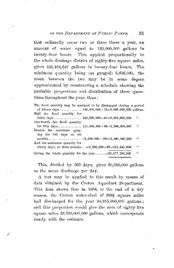
that ordinarily occur two or three times a year, an amount of water equal to 130,000,OC~O gallons in twenty-four hours. This applied proportionally to the whole drainage district of eighty-five square miles,
gives 446,464,646 gallons in twenty-four hours. The minimum quantity being (as gauged) 6,836,040, the mean between the two may be in some degree approximated by constructing a schedule showing the probable proportions and distribution of these quan-
tities throughout the year, thus :
The flood quantity may be assumed to be discharged during a period ............. of fifteen days. 446,400,000 + 15=6,696,000,000 gallons.
Half the flood quantity for ................. thirty days 223,200,000 + 30=6,896,000,000 "
One-fourth the flood quantity ............. for fifty days. 111,600,000 + 50=5,580,000,000 "
Double the minimum quan- tity for 180 days or six .. months. .................. 13,836,000 t 180=2,490,480,000
And the minimum quantity for . . ninety days, or three months. =6,836,000+ 90=615,240,000 "
Giving the whole quantity for the year ...... =23,077,720,000 <I
This, divided by 365 days, gives 60,500,000 gallons as the mean discharge per day
A test may be applied to this result by means of data obtained by the Croton Aqueduct Department. This data shows that in 1864, at the end of a dry season, the Croton water-shed of 3382 square miles had discharged for the year 94,815,000,000 gallons ; and this proportion would give the area of eighty-five square miles 23,790,000,000 gallons, which corresponds nearly with the estimate.
It is to be observed that only one-fifth of the above quantity obtained from the Croton water-shed was utilized and passed througli the aqueduct; four-fifths passing off over the Croton dam.
The whole quantity was forty-four per cent of about a niinimuni annual rain-fall.
The per centage of rain-fall that is generally taken
as practicable to be utilized by means of reservoirs, is about fifty per cent. Hut the per centage discharged by streams, obtained by observations of this kind, cannot be safely taken in all cases, as reprensenting the quantity of water that may be actually utilized. If the district drained is sterile and uncultivated, it may be practicable to intercept and shut up within it the flowing streams, and reserve all the falling water except that wliich evaporates or filters away. And it
may be practicable, supposing the exterior or lower district watered by the natural flow of the streams is of similar character, to cut off from it and convey away to a distant population all the water stored ; but these are conditions that are not often found to exist. I11 the present case, the contemplated drainage district, as well as a considerable district to the south of it, receiving the natural discharge of the streams, is cultivated and populous, and must be regarded as dependent upon the preservation, in a greater or less degree, of a normal condition of water-flow. How much this condition may be impaired, or how much of the falling water may be stopped in its circulation, stored up i11 reservoirs, and diverted from its natural channels and natural uses and functions, without
detriment, is a practical question that it becomes unnecessary to investigate.
It is also important, in connection with this point, to know whether natural facilities exist in the con- figuration of the drainage district for the formation of
reservoirs of adequate capacity. This can only be determined by surveys. Another question to be devel- oped also by surveys and the consideration of tenden- cies of population, character of occupancy of the district, etc., is whether the requisite quantity of water can be obtained and gathered into reservoirs in a pure and wholesome condition.
For the purpose of getting at a present approxi- mate result (and I believe a safe one) in the absence of the necessary information on these points, I assume that it will be practicable to reserve and utilize one-
fourth or twenty-five per cent of the rain-fall, leaving an equal amount to its free flow to meet the contin- gencies mentioned. There is not much doubt that reservoir facilities can be found, should it become expedient to resort to them, for storing a t least such an amount of water.
Taking thirty-six inches as about the minimum of annual rain-fall, and one-fourth of it as available, we
have - 3 ~ by eighty-five square miles = 13,329,360,000 gal- lons of water per annum, or u 2 + $ 6 m = 3 6 , 5 1 8 , 7 9 4 gallons per twenty-four hours (which it will be seen is over five times the quantity furnished by the mini- mum natural flow) ; and if we take sixty gallons per
twenty-four hours a s the allowance for each person,
we have ww, 608,646, as the amount of popula- tion it will supply.
I conclude, from this result, that it is practicable to supply the district in question, from local sources, to the extent contemplated by the Legislature. But
whether circumstances of population and occupancy of the drainage district in prospect may be regarded as affecting the expediency of such a mode of supply, and whether a resort to more distant sources, as the Croton water-shed, may be more desirable and econo- mical, are questions that are deferred for further con- sideration.
The quality of the water furnished by the drainage district is good, having been found, by analysis, to compare very favorably with the Croton water. Owing to the height of ground of a considerable portion of the district to be supplied, the water will have to be raised to a higher level tha,n that of the storage reser- voirs, by pumping. This would also be the case from whatever source the water might be obtained.
Very respectfully,
WILLIAM H. GRANT, Bngineer in Charge.
C O P Y
YOItTIONS OF CONTRACTS AND SPECIFICATIONS
FOR
The said surveys and maps to be made according to the following specifications :
The ground work of the survey to be a series of longitudinal lines parallel with the direction of Tenth avenue, in the city of New York, and similar trans- verse parallel lines at right angles therewith, all 100 feet apart.
The standard of measure to be used to be the same as the standard at the old arsenal in Central park. All the work to be done and returned with such accuracy, that, when tested by calculations, or by measurements on the ground, no greater variations shall exist in any part, line, traverse, angle or mea- sure, than at the rate of fifteen one-hundredths of a foot in 1,000 feet of length or distance.
Every eighth line, at least, of the said longitudinal and transverse lines shall be traverse lines of survey, traced by measurements and angles.
36 REPORT OF THE BOARD OF C o n r ~ r s s r o x ~ ~ s
The survey and maps to include, by measnrrments, traverses and angles, all buildings, streams, brooks and visible rock surfaces ; all visible boundaries of properties, and all roads, streets, avenues and lanes, and the same to have such reference by measure- ments and angles with the said longitudinal and transverse lines as to admit of the verification of tlie work by calculation.
Levels above high tide are to be taken, and shown on the maps at every intersectioii of the said longi- tudinal and transverse lines, and a t least at every fifty feet in distance along the center of all streets, avenues, roads and lanes now open and in use, and along the course of streams and brooks, also along the boundary lines of all properties more than three acres in extent each, and as frequently a t other points as will correctly delineate the altitudes of the surface, to allow of contour lines being drawn from such levels. Tlie standard of high tide to be the same as that used by tlie said department of public parks in the city of New York north of One Hundred and Fifty-fifth street, as represented by a bench mark on
l
a monument on the late established easterly line of Kingsbridge road, at a point about twenty feet north- easterly from the north-easterly corner of "Kings- bridge hotel," the elevation of the said bench mark above high tide being three and two-tenths (3&) feet.
Bench marks to be made and verified a t or about every one thousand feet of distance, longitudinally
and transversely; such marks to be made on the most permanent and convenient objects accessible,
and a plain reference to them, together with their height of elevation above high tide, to be noted on the margin of the maps. The bench marks to be established with such accuracy that no error shall exist, with reference to the standard of high tide before mentioned, greater than five one-hundredths of a foot, and the elevations of tlie ground are to be taken and shown with such accuracy, that no error shall exist, with reference to said standard of high tide, greater than two-tenths of a foot.
At every one hundred feet or less of distance, longitudinally and transversely, and wherever prac- ticable (at such distances) at the intersections of the longitudinal and transverse lines, monuments accu- rately connected with the survey are to be estab- lished, either by proper iron bolts secured in the rock, or a locust post firmly set, or a corner or other part of a building, or by some other appropriate and permanent means ; such monuments to be desig- nated on the maps naming the kind of monument.
The maps to be drawn on the scale of eighty feet to one inch, on separate sheets of the best English double elephant drawing paper, well mounted mus- lin, with a plain margin one and a half inches wide around each sheet, and so that boundary lines on all sheets will conform accurately with other sheets of
the survey. Roads and streets, as legally laid out and opened
by law, to be shown by fine solid red lines. Roads and streets dedicated but not in use, to be
shown by fine dotted red lines.
Streams, brooks, ponds, rivers, and elevations above high tide, to be shown by blue lines and figures.
Boundary lines of separate properties, to be shown by black dotted lines.
All transverse lines, angles, and distances measured, to be shown by plain green lines and figures.
Such longitudinal and transverse lincs as are not transverse lines, to be shown by finer green lines than the transverse lines.
Names of present owners of properties, to be writ- /
ten on each parcel in fine black italic letters. Brick and stone buildings, to be designated by red
color. Frame buildings, by a light shade of India ink. Green houses and other structures of glass, by a light green color. Prominent rocks and rocky sur- faces, by India ink topography.
Each separate sheet of the maps to be dated and signed by the surveyor, or surveyors and draughts- man, making the same on the margin of the sheet when it is returned to the said department of public parks.
The work to be prosecuted and coinpleted in regu- t lar order, commencing at the southerly boundary and
progressing by parallel transverse lines northwardly.
And I hereby agree to do the whole of the foregoing work, in accordance with the specifications and con- ditions herein contained, and to the satisfaction and acceptance of the said department of public parks, or of the engineer in charge of the bureau of civil and topographical engineering. * * * And to receive as full compensation for all services, labor, materials,
use of instruments, office rents, and all services and materials of every nature and kind whatsoever, in and about said surveys and maps, at and after the rate of
per acre for the quant'ity of land surveyed within the limits herein before described, and to receive the payments after the sheets and maps have been returned, examined, tested and approved as aforesaid, in installments at the rate of per acre for the quantity of acres surveyed and drawn on the sheets
so returned and approved; but no payment shall be asked or demanded by me at any one time, for less than one hundred acres of land surveyed, mapped, and returned and approved, as aforesaid, except at the completion of the whole work agreed for, or at the termination of this agreement, as herein after provided, when all balance due and unpaid under this agreement shall be due and payable.
But it is expressly understood and agreed that no payment shall be demanded by me except from funds provided by the supervisors of the county of West- Chester, pursuant to the provisions of chapter 826 of the Laws of 1869, and chapter 797 of the Laws of 1870, for the purpose of paying for such surveys
when funds so provided are in the possession of the said department of public parks for such purpose; and that I will look solely to such funds, so provided, for my remuneration under this agreement. I further agree that the work shall be done under my personal supervision and that I will not sublet the same, or any part thereof.