Embed Size (px)
Citation preview
Repsol Exploration Australia
Repsol 3D and 2D Marine Seismic and Geological Sampling Surveys (WA-480-P)
Environment Plan Summary
Revision: 0 Issue Date: 19 April 2013 Uncontrolled when Printed

Repsol 3D and 2D Marine Seismic and Geological Sampling Surveys (WA-480-P) Environment Plan Summary
Repsol Exploration Australia ii | P a g e
U n c o n t r o l l e d w h e n P r i n t e d
CONTENTS
1. INTRODUCTION ................................................................................................................ 1
1.1 Contact Details .................................................................................................................... 1
2. DESCRIPTION OF ACTIVITY ............................................................................................ 2
2.1 Location .............................................................................................................................. 2
2.2 Seismic survey description ................................................................................................. 5
3. DESCRIPTION OF RECEIVING ENVIRONMENT ............................................................. 6
3.1 Physical environment .......................................................................................................... 6
3.2 Biological environment ........................................................................................................ 6
3.2.1 Benthic invertebrates ............................................................................................. 8
3.2.2 Fish and sharks ...................................................................................................... 8
3.2.3 Reptiles (Turtles) .................................................................................................... 8
3.2.4 Reptiles (Sea-snakes) ............................................................................................ 9
3.2.5 Seabirds ................................................................................................................. 9
3.2.6 Marine mammals.................................................................................................. 10
3.3 Cultural and social-economic environment ....................................................................... 10
3.3.1 Fisheries ............................................................................................................... 11
3.3.2 Commercial shipping ........................................................................................... 11
3.3.3 Tourism ................................................................................................................ 12
3.3.4 Defence activities ................................................................................................. 12
3.3.5 Petroleum activities .............................................................................................. 12
3.3.6 Subsea Cables ..................................................................................................... 12
3.3.7 Heritage values .................................................................................................... 12
3.3.8 Values and sensitivities ........................................................................................ 13
4. ENVIRONMENTAL HAZARDS AND CONTROLS ........................................................... 14
5. MANAGEMENT APPROACH ........................................................................................... 17
6. STAKEHOLDER CONSULTATION .................................................................................. 19
7. REFERENCES ................................................................................................................. 21
Repsol 3D and 2D Marine Seismic and Geological Sampling Surveys (WA-480-P) Environment Plan Summary
Repsol Exploration Australia 1 | P a g e
U n c o n t r o l l e d w h e n P r i n t e d
1. INTRODUCTION
Repsol Exploration Australia (Repsol) propose to undertake a three-dimensional (3D) seismic survey
of 2,000 square kilometers (km2) (full fold) during May-July of 2013 and a two-dimensional (2D)
seismic survey of 1,800 km (full fold) and a sea bed coring program of thirty-one (31) stations during
the second-third quarters of 2014.
This Environment Plan (EP) has been prepared for submission to the National Offshore Petroleum
Safety and Environmental Management Authority (NOPSEMA) in accordance with the requirements
of the Offshore Petroleum and Greenhouse Gas Storage (Environment) Regulations 2009
[OPGGS(E)R] and Amendment Regulations 2011. The EP was accepted by NOPSEMA on 10 April
2013.
This EP summary is prepared pursuant to Regulation 11(8) of the OPGGS(E)R.
1.1 Contact Details
Repsol Exploration Australia Pty Ltd is the holder of the WA-480-P block permit and is the appointed
Operator.
Contact details for the appointed operator:
Elvira Alvarez de Buergo
Asia Pacific Regional Exploration Director
Repsol Exploration Australia Pty Ltd:
Level 28, Riparian Plaza
71 Eagle Street, Brisbane City Qld 4000
Ph. +34917535613
Repsol 3D and 2D Marine Seismic and Geological Sampling Surveys (WA-480-P) Environment Plan Summary
Repsol Exploration Australia 2 | P a g e
U n c o n t r o l l e d w h e n P r i n t e d
2. DESCRIPTION OF ACTIVITY
2.1 Location
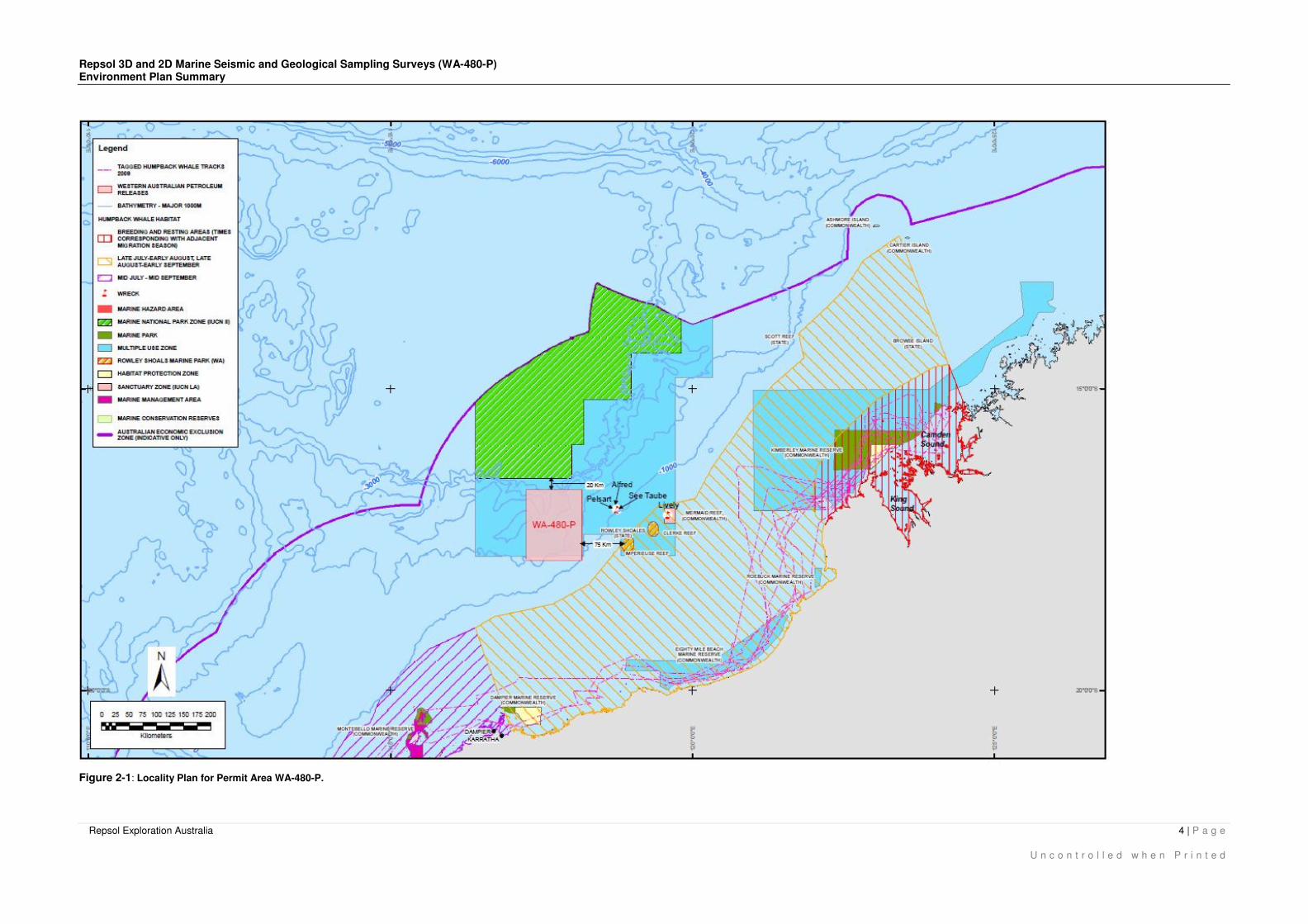
The activities will occur within Permit Area WA-480-P located in the North Carnarvon Basin in the NE
corner of the Exmouth Plateau approximately 300 km offshore from Dampier. The Permit Area is
approximately 12,548 km2, in water depths ranging from 1,000 to 4,500 meters (m).
The operational area for 3D seismic survey is detailed in Table 2-1 below. The proposed 2D lines are
within the wider Permit Area, the geographical coordinates for these lines are provide in Table 2-2
below. The geological sampling (sea bead coring) has been proposed at thirty-one (31) stations,
however some specific final locations will be agreed with Telstra in order to avoid impact to
communications infrastructure within the Permit Area. Figure 2-1 below is a locality plan showing the
Permit Area within the region.
Table 2-1: Approximate geographic coordinates of the 3D seismic survey operational area
Latitude (S) Longitude (E)
Degrees Minutes Seconds Degrees Minutes Seconds
17 8 01.67 117 46 28.57
17 7 55.58 118 9 31.89
17 35 01.15 118 9 35.74
17 35 07.92 117 46 33.52
GDA 1994
Table 2-2: Proposed geographic coordinates of the operational area for the 2D seismic survey
lines.
Lines Latitude (S) Longitude (E)
Degrees Minutes Seconds Degrees Minutes Seconds
1 117 15 5.74 16 48 27.58
1 117 25 0.07 16 40 0.3
2 117 30 39.73 17 40 37.68
2 117 14 59.6 17 20 57.64
3 117 15 0.87 16 54 39.55
3 117 32 46.29 16 40 4.42
4 117 30 27.68 17 34 50.86
4 117 15 0.71 17 16 27.15
5 117 15 6.69 17 0 20.5
5 117 40 5.74 16 39 57.96
6 117 14 52.11 17 10 52.72
6 117 36 15.37 17 36 55.15
8 117 40 20.22 17 33 7.17
8 117 15 8.87 17 1 37.28
9 117 15 1.76 17 9 52.5
9 117 53 13.24 16 40 2.18
10 117 15 16.12 16 56 16.11
10 117 43 21.65 17 31 53.67
11 117 15 2.47 17 14 37.41
Repsol 3D and 2D Marine Seismic and Geological Sampling Surveys (WA-480-P) Environment Plan Summary
Repsol Exploration Australia 3 | P a g e
U n c o n t r o l l e d w h e n P r i n t e d
Lines Latitude (S) Longitude (E)
Degrees Minutes Seconds Degrees Minutes Seconds
11 117 59 8.66 16 40 1.72
12 117 15 7.98 16 50 32.46
12 117 45 17.55 17 29 27.32
13 117 14 58.6 17 22 25.61
13 118 9 55.99 16 40 0.47
14 117 14 41.05 16 41 17.06
14 117 51 43.47 17 28 1.23
15 117 58 0.87 16 52 57.97
15 118 10 0.19 16 43 7.58
16 117 35 57 17 3 7.68
16 117 17 53.2 16 39 59.26
17 117 15 7.52 17 30 4.93
17 118 10 1.95 16 46 50.58
18 118 1 11.42 17 30 11.27
18 117 22 4.66 16 39 50.46
19 117 15 8.13 17 37 24.02
19 118 9 56.02 16 55 1.32
21 117 15 8.76 17 45 0.33
21 117 51 0.45 17 16 40.88
22 117 51 57.68 17 8 20.34
22 117 28 49.45 16 40 4.03
23 117 52 6.68 17 24 1.51
23 117 18 34.8 17 49 57.05
24 117 46 10.06 16 56 28.49
24 117 32 39.58 16 40 0.63
26 117 2 8.19 17 11 19.43
26 117 37 41.9 16 40 11.24
28 117 41 14.49 16 40 16.04
28 117 51 51.32 16 53 36.29
30 118 2 51.05 17 2 24.85
30 117 44 24.17 16 39 57.62
32 117 48 14.47 16 40 0.17
32 118 0 26.59 16 54 30.66
34 118 9 15.27 17 0 8.28
34 117 52 12.05 16 39 58.05
36 118 9 59.51 16 52 27.79
36 117 59 48.87 16 40 4.54
Repsol 3D and 2D Marine Seismic and Geological Sampling Surveys (WA-480-P) Environment Plan Summary
Repsol Exploration Australia 4 | P a g e
U n c o n t r o l l e d w h e n P r i n t e d
Figure 2-1: Locality Plan for Permit Area WA-480-P.
Repsol 3D and 2D Marine Seismic and Geological Sampling Surveys (WA-480-P) Environment Plan Summary
Repsol Exploration Australia 5 | P a g e
U n c o n t r o l l e d w h e n P r i n t e d
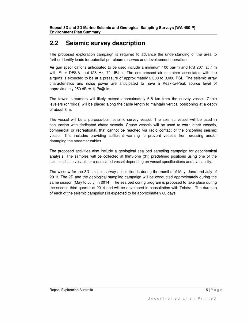
2.2 Seismic survey description
The proposed exploration campaign is required to advance the understanding of the area to
further identify leads for potential petroleum reserves and development operations.
Air gun specifications anticipated to be used include a minimum 100 bar-m and P/B 20:1 at 7 m
with Filter DFS-V, out-128 Hz, 72 dB/oct. The compressed air container associated with the
airguns is expected to be at a pressure of approximately 2,000 to 3,000 PSI. The seismic array
characteristics and noise power are anticipated to have a Peak-to-Peak source level of
approximately 250 dB re 1µPa@1m.
The towed streamers will likely extend approximately 6-8 km from the survey vessel. Cable
levelers (or ‘birds) will be placed along the cable length to maintain vertical positioning at a depth
of about 8 m.
The vessel will be a purpose-built seismic survey vessel. The seismic vessel will be used in
conjunction with dedicated chase vessels. Chase vessels will be used to warn other vessels,
commercial or recreational, that cannot be reached via radio contact of the oncoming seismic
vessel. This includes providing sufficient warning to prevent vessels from crossing and/or
damaging the streamer cables.
The proposed activities also include a geological sea bed sampling campaign for geochemical
analysis. The samples will be collected at thirty-one (31) predefined positions using one of the
seismic chase vessels or a dedicated vessel depending on vessel specifications and availability.
The window for the 3D seismic survey acquisition is during the months of May, June and July of
2013. The 2D and the geological sampling campaign will be conducted approximately during the
same season (May to July) in 2014. The sea bed coring program is proposed to take place during
the second-third quarter of 2014 and will be developed in consultation with Telstra. The duration
of each of the seismic campaigns is expected to be approximately 60 days.

Repsol 3D and 2D Marine Seismic and Geological Sampling Surveys (WA-480-P) Environment Plan Summary
Repsol Exploration Australia 6 | P a g e
U n c o n t r o l l e d w h e n P r i n t e d
3. DESCRIPTION OF RECEIVING ENVIRONMENT
3.1 Physical environment
The Block is located within the Exmouth Plateau. The region has a tropical monsoonal climate with
two distinct seasons known as wet season (November-April) and dry season (May-September).
Rain during summer is generally heavy and erratic due to the tropical storms and cyclones. The
official cyclone season is from November to April annually. During winter, the region is dominated
by intense anti-cyclonic belts (high pressure systems) which generate strong winds (predominantly
from the east and south-east) and infrequent rain. Summer conditions are more variable, with
varying wind directions (although south-westerly winds are the most common) (BOM 2012).
Deep current systems dominate the Exmouth Plateau, including the Leeuwin Current and
circulation of the Indonesian Throughflow via the South Equatorial Current (Brewer et al. 2007).
Due to the interaction of tides with the topography of the Plateau, the area is also influenced by
strong tidal activity with internal waves causing deep-water upwelling, which increases biological
productivity at the shelf break (Brewer et al. 2007).
The sediments in the survey comprise muddy sand and sandy mud (Brewer et al. 2007). Most
sediment that occurs on the shelf has been derived from the in-situ breakdown of marine material
and is either relic or recent carbonate deposits. Further down the slope of the North Carnarvon
basin in the deeper regions, studies indicate the sea bed consists of fine muddy carbonate
sediments (DEWHA 2007).
3.2 Biological environment
A desktop search of the Permit Area, including a 20 km buffer (Search Area) was undertaken
using the Department of Sustainability, Environment, Water, Population and Communities
(DSEWPAC’s) Protected Matters Search Tool to identify matters of National Environmental
Significance (NES) protected under the Environmental Protection and Biodiversity Conservation
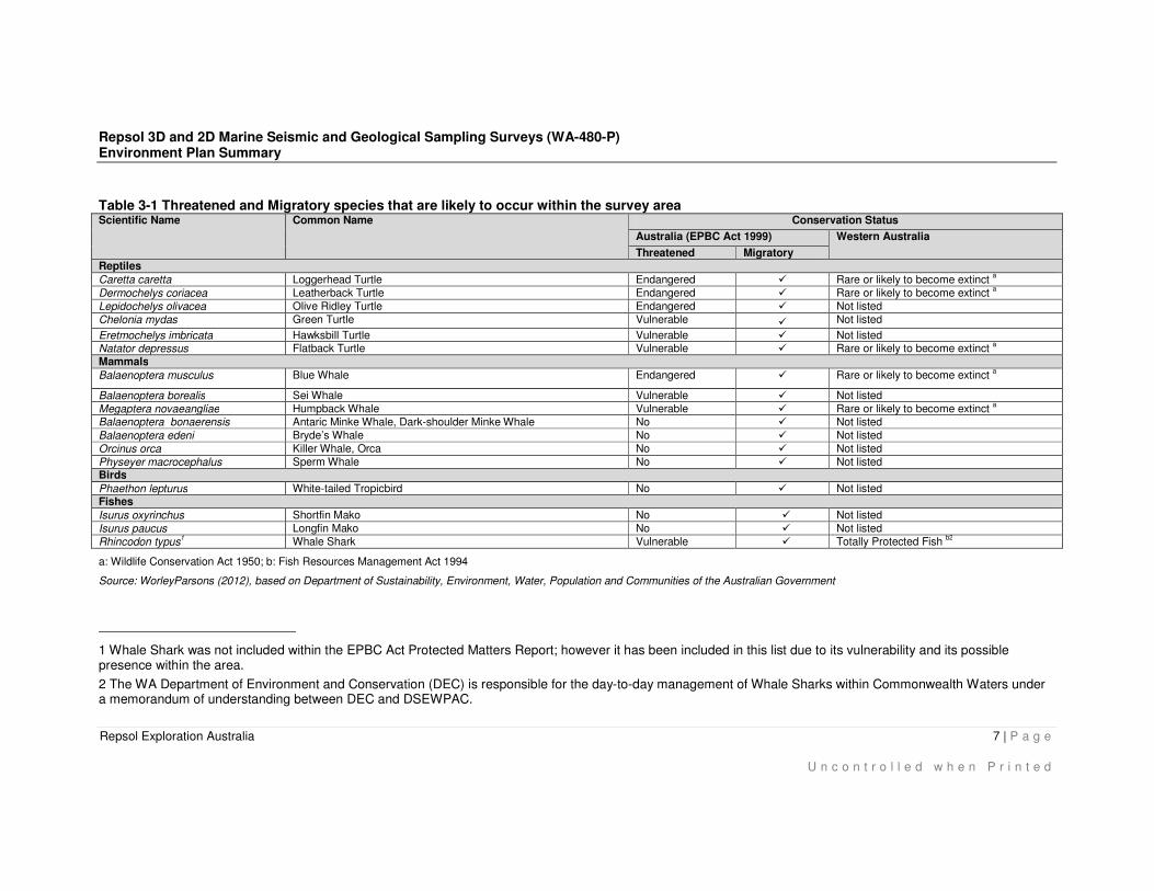
Act 1999 (EPBC Act). The search results identified the following:
• nine listed threatened species (with only one ‘likely’ to occur in the Search Area); and
• sixteen migratory species (with only four considered ‘likely’ to occur in the Search Area of
which only one is listed as threatened under the EPBC Act).
Table 3-1 below provides a summary of these listed threatened and migratory species and
includes the conservation status according to Western Australia (WA) regulations.
Repsol 3D and 2D Marine Seismic and Geological Sampling Surveys (WA-480-P) Environment Plan Summary
Repsol Exploration Australia 7 | P a g e
U n c o n t r o l l e d w h e n P r i n t e d
Table 3-1 Threatened and Migratory species that are likely to occur within the survey area Scientific Name Common Name Conservation Status
Australia (EPBC Act 1999) Western Australia
Threatened Migratory Reptiles
Caretta caretta Loggerhead Turtle Endangered � Rare or likely to become extinct a
Dermochelys coriacea Leatherback Turtle Endangered � Rare or likely to become extinct a
Lepidochelys olivacea Olive Ridley Turtle Endangered � Not listed
Chelonia mydas Green Turtle Vulnerable � Not listed
Eretmochelys imbricata Hawksbill Turtle Vulnerable � Not listed
Natator depressus Flatback Turtle Vulnerable � Rare or likely to become extinct a
Mammals
Balaenoptera musculus Blue Whale Endangered � Rare or likely to become extinct a
Balaenoptera borealis Sei Whale Vulnerable � Not listed
Megaptera novaeangliae Humpback Whale Vulnerable � Rare or likely to become extinct a
Balaenoptera bonaerensis Antaric Minke Whale, Dark-shoulder Minke Whale No � Not listed
Balaenoptera edeni Bryde’s Whale No � Not listed
Orcinus orca Killer Whale, Orca No � Not listed
Physeyer macrocephalus Sperm Whale No � Not listed Birds
Phaethon lepturus White-tailed Tropicbird No � Not listed Fishes
Isurus oxyrinchus Shortfin Mako No � Not listed
Isurus paucus Longfin Mako No � Not listed
Rhincodon typus1 Whale Shark Vulnerable � Totally Protected Fish
b2
a: Wildlife Conservation Act 1950; b: Fish Resources Management Act 1994
Source: WorleyParsons (2012), based on Department of Sustainability, Environment, Water, Population and Communities of the Australian Government
1 Whale Shark was not included within the EPBC Act Protected Matters Report; however it has been included in this list due to its vulnerability and its possible presence within the area.
2 The WA Department of Environment and Conservation (DEC) is responsible for the day-to-day management of Whale Sharks within Commonwealth Waters under a memorandum of understanding between DEC and DSEWPAC.
Repsol 3D and 2D Marine Seismic and Geological Sampling Surveys (WA-480-P) Environment Plan Summary
Repsol Exploration Australia 8 | P a g e
U n c o n t r o l l e d w h e n P r i n t e d
3.2.1 Benthic invertebrates
Very little is known about the benthos of the Exmouth Plateau, however it is believed the sediments
are primarily muddy sand and sandy mud, suggesting the Plateau would likely support infauna
benthos including meiobenthic fauna comprising of nematodes, and macrobenthic fauna comprising
polychaete worms and isopods, and epibenthic communities such as deep-water sea cucumbers,
crabs and polychaetes (Brewer et al. 2007). The benthic habitat may also support the presence of
bentho-pelagic fish and cephalopods in low densities (Brewer et al. 2007).
3.2.2 Fish and sharks
The Longfin Mako shark is found worldwide in tropical, warm temperate oceans at depths up 220 m
(De Maddalena 2005). The Shortfin Mako is pelagic found in temperate to tropical waters, usually in
coastal waters up to 50 m depth and open waters, and may occasionally dive to depths over 600 m
(Heist & Schrey 2003). Mako sharks are unlikely to occur in large numbers in the Permit Area due to
the depth of water.
Given the depth preference (between 225 and 1,000 m) rich assemblages of demersal fish species
found in the Northwest Transition bioregion are unlikely to be present in the Permit Area. However,
transient populations of highly mobile pelagic fish (e.g. southern bluefin tuna) may transit the Permit
Area due to their use of dominant oceanic currents in the bioregion to assist with migrations to
spawning grounds (DRET 2008).
Whale sharks have a wide distribution in tropical to warm temperate oceanic and coastal waters,
generally in areas of upwelling. Ningaloo Reef is listed as an important aggregation and feeding area
for the species especially from March to July during periods of high productivity (DSEWPAC 2012).
Whale sharks are seasonally sighted between December and January at Ashmore Reef and
Christmas Island. Offshore sightings are not uncommon, however the species attracts more attention
in coastal waters where they are often observed close to the sea surface; making the species
susceptible to vessel strikes.
3.2.3 Reptiles (Turtles)
Studies by Berry (1986) indicate both Green and Hawksbill turtles are present at the Rowley Shoals,
however no turtle feeding areas are likely to be present in the Permit Area. Seagrass and algae are
the main food source for Green turtles; therefore, their main foraging areas occur around these
habitats. The closest known major breeding/nesting grounds for these species are the Dampier
Archipelago nesting grounds, approximately 300 km onshore from the Permit Area. The largest
rookeries for Hawksbill turtles occur at Varanus and Rosemary Island (Pendoley 2005),
Nesting areas of Flatback turtles within WA range from Exmouth to the Lacepede Islands, with
significant rookeries also located around the Dampier Archipelago, Barrow, Thevenard and Varanus
Islands, the Montebello Group, the Kimberley region, and on some mainland beaches including
Mundabullangana (Limpus 2008). Feeding occurs near shore and on soft bottomed habitats away
from reefs. The species targets soft bodied invertebrates (Limpus 2009).
Repsol 3D and 2D Marine Seismic and Geological Sampling Surveys (WA-480-P) Environment Plan Summary
Repsol Exploration Australia 9 | P a g e
U n c o n t r o l l e d w h e n P r i n t e d
Loggerhead turtles (Caretta caretta) have a global distribution throughout tropical, sub-tropical and
temperate waters (Marquez 1990). In Australia, they generally occur around coral and rocky reefs,
seagrass beds and muddy bays throughout Eastern, Northern and WA. Known nesting areas in
Australia include southern Queensland (QLD) and the northwest coast of WA, but the species moves
much more broadly for foraging (DSEWPAC 2011). In WA, nesting occurs from Shark Bay to the
North West Cape, with the Dampier Archipelago being the closest known nesting ground to the
Permit Area (Limpus 2008). Mature Loggerhead turtles feed on benthic invertebrates such as
molluscs and bivalves while juvenile turtles feed on algae and pelagic crustaceans (Limpus 2008).
The Olive Ridley turtle (Lepidochelys olivacea) is the smallest Australian marine turtle and is the most
numerous of all marine turtles due to nesting aggregations occurring worldwide. However, no large
rookeries have been identified in WA (DSEWPAC 2012). The species forages on shallow benthic
habitats and is commonly found in soft-bottomed habitats around the northern parts of Australia
including the Dampier Archipelago region (Limpus 2008). Olive Ridley turtles are carnivorous,
feeding predominantly on gastropods and bivalve molluscs (DSEWPAC 2012).
The Leatherback turtle (Dermochelys coriacea) has the widest distribution of any marine turtle, and
can be found in tropical, subtropical and temperate waters throughout the world (Marquez, 1990).
Within Australia, foraging Leatherback turtles have been recorded in all States, although no major
nesting areas have been identified, only low density nesting was recorded around the Northern
Territory (NT) and Queensland (QLD) (Limpus, 2009). Leatherback turtles are primarily a pelagic
feeder, preferring areas of upwelling and convergence of ocean currents, where food source such as
jellyfish are likely to occur in abundance (DSEWPAC 2012).
Turtles may occasionally pass through the Permit Area but due to the distance from known nesting,
foraging and breeding areas it is unlikely the proposed activities will affect these species.
3.2.4 Reptiles (Sea-snakes)
Several sea-snakes have been identified in the EPBC search as species that ‘may occur’ within
Permit Area WA-480-P. Although sea-snakes may occur within the Permit Area, they generally prefer
shallow reef or sandy habitats (DSEWPAC 2012), therefore the depth, lack of bathymetry features
and distance from significant habitat makes it unlikely to represent significant aggregation zones.
3.2.5 Seabirds
The migratory White-tailed Tropicbird (Phaethon lepturus) identified on the EPBC Protected Matter
search is highly mobile and is generally distributed off the coast in tropical and subtropical waters
(IUCN 2012). The White-tailed Tropicbird nests onshore in tree hollows and in rock crevices
(DSEWPAC 2012). The proposed survey area is located offshore and does not contain any critical
habitat for the White-tailed Tropicbird; therefore, it is unlikely the species would be impacted by the
proposed activities.
Fourteen birds listed under the IUCN conservation status were identified as ‘may occur’ in the Permit
Area. Although these species may fly over the Permit Area, the closest breeding, nesting and feeding
Repsol 3D and 2D Marine Seismic and Geological Sampling Surveys (WA-480-P) Environment Plan Summary
Repsol Exploration Australia 10 | P a g e
U n c o n t r o l l e d w h e n P r i n t e d
areas are approximately 77 km from the Permit Area at the Rowley Shoals. The closest Important
Bird Areas (IBA) is located at Bedout Island, approximately 217 km from the Permit Area.
3.2.6 Marine mammals
Several species of cetacean are known to frequent the waters within the vicinity of the survey area,
including seven species of whale identified on the EPBC Act protected matter search.
Humpback whales (Megaptera novaeangliae) are the most commonly sighted whale species in WA,
often sighted during their southern migration when they travel closer to the coast. The northern
migration of Humpback whales peaked during the end of July and start of August and sightings are
generally recorded along the 200 m bathymetry line, approximately 10 nautical miles offshore
(DSEWPAC 2012 & Jenner et al 2001). The nearest breeding area to the proposed survey area is
Camden Sound, approximately 647 km from the Permit Area. Humpback whales are known to use
the calving areas between Broome and the Northern end of Camden Sound between June and mid-
November (Jenner et al 2001). On their southern migration, cow-calf pairs frequently rest in
aggregation areas along the west Australian coastline, with the closest aggregation area to the Permit
Area (approximately 522 km distance away) being Exmouth Gulf (DSEWPAC 2012). Although
Humpback whales may occasionally transit the Permit Area, the proposed survey will be conducted in
depths greater than 1,000 m is outside (seaward) of the main humpback migration routes and distant
from known feeding, breeding and resting areas.
Blue whales (Balaenoptera musculus) range from polar to tropical waters during their annual
migrations between temperate waters in summer and tropical waters in winter (DEH 2005). In
Australia, areas of feeding significance for Blue whales include the Perth Canyon in WA, the Bonney
upwelling in southeast South Australia (SA) and the Duntroom Basin in SA to Victoria’s western
waters (DEH 2005). The Blue whale is rarely present in large numbers outside recognised
aggregation areas. Influenced by the presence of food source, blue whales appear to follow deep
oceanic routes during migration and are generally associated with waters deeper than the continental
shelves (Branch et al 2007). Blue whales breed in tropical waters during winter with calving peaking
in May to June, however the exact breeding grounds of this species are unknown (Bannister et al.,
1996). Blue whales may occasionally transit the area, however, no known aggregation or breeding
areas are located within the Permit Area.
Several other whales are identified in the EPBC Act protected matter search including Sei whales
(Balaenoptera borealis), Bryde’s whale (Balaenoptera edeni), Sperm whale (Physeter
macrocephalus), Antarctic Minke whale (Balaenoptera bonaerensis) and Killer whales (Orcinus orca).
Significant numbers of these whales are not expected to be encountered as the permit area is not
recognised as a feeding, breeding, aggregation or significant habitat for these species.
3.3 Cultural and social-economic environment
The desktop Protected Matters search of the Permit Area, including a 20 km buffer (Search Area)
identified that:
Repsol 3D and 2D Marine Seismic and Geological Sampling Surveys (WA-480-P) Environment Plan Summary
Repsol Exploration Australia 11 | P a g e
U n c o n t r o l l e d w h e n P r i n t e d
• there are no world heritage or national heritage properties or places were identified within the
operational area (this includes shipwrecks);
• there are no listed threatened ecological communities within the operational area and adjacent
waters; and
• the operational area overlaps one Commonwealth marine area.
3.3.1 Fisheries
The greater North-west Marine region of WA is an active commercial fishing area used by both
Australian and Indonesian fishermen. Information provided by the WA Department of Fisheries (DoF)
indicates that no fishing activity has been reported in the Permit Area, noting that fishing activity may
change and/or the area may be historical fishing grounds.
No charter boat operators, governed by the WA State Government have been identified or are likely
to utilise the Permit Area. Similarly, based on information provided by Recfishwest (the peak body for
recreational fishers in WA), the proposed activities Permit Areas do not pose a risk to recreational
fishers.
There are four main commercial fisheries governed by the Australian Fisheries Management Authority
(AFMA), operating in the general area including:
• The North West Slope Trawl Fishery (NWSTF)
• The Western Tuna and Billfish Fishery (WTBF)
• Southern Bluefin tuna fishery (SBTF)
• Western Skip-jack fishery (WSJF)
Of the four, the most likely fishery to conduct planned fishing within Permit Area is the WTBF. The
WTBF targets yellowfin tuna, big eye tuna, skipjack tuna, albacore, tuna and billfish (AFMA). The
AusAsia Group has negotiated control of over 70% of the Tuna fishery in this region, and has
commenced introducing their long line vessels (Source: WTBF correspondence). The fishers
operating in the WTBF have requested that they are kept up-to-date of Repsol’s proposed activities.
April to August represents the off season for these tuna fishing operations at present.
It is unlikely fisheries will be impacted by the proposed survey as these are considered to be small
fisheries operating within the wider region. No fishing activities have been identified during the
proposed timing of the campaigns.
3.3.2 Commercial shipping
Shipping in the area is extensive with many designated shipping lanes passing through the region.
The Dampier shipping fairway passes close to the Permit Area and, approximately 65 km from the
western border, however no ‘registered’ shipping routes between Port Hedland, Dampier and Lombok
Strait pass directly through Permit Area WA-480-P. AMSA has also established a new network of
Shipping Fairways, though none pass through the Permit Area. Noting that, once outside the
‘registered’ shipping routes and/or ports, vessels are responsible to chart their own course (Source:
Repsol 3D and 2D Marine Seismic and Geological Sampling Surveys (WA-480-P) Environment Plan Summary
Repsol Exploration Australia 12 | P a g e
U n c o n t r o l l e d w h e n P r i n t e d
PHPA correspondence). Despite the fact that no ‘registered’ shipping routes through the Permit Area
are charted, shipping activity, provided by AMSA, indicates significant shipping traffic within the
Permit Area. Ongoing consultation with AMSA and the Australian Hydrographic Service (AHS) is
being conducted to ensure that shipping activities are made safe through issuing Notices to Mariners
and adopting support vessels to warn other vessel traffic.
3.3.3 Tourism
The proposed survey area is located in a remote area (approximately 280 km offshore from Port
Hedland) and is therefore unlikely to be of interest to recreational fishing or any tourist activities.
Recreational fishing occurs in state waters adjacent the Northwest Marine Region and it is possible
that occasionally motor vessels or yachts will pass through the area. The closest whale watching
tours are located 925 km southwest of the Permit Area WA-480-P at Monkey Mia in Shark Bay. The
closest tourist activities would be held at the Rowley Shoal Marine Park 77 km east of the Permit
Area.
3.3.4 Defence activities
There are no known defence activities taking place in or near the proposed survey activities in Permit
Area WA-480-P.
3.3.5 Petroleum activities
Current operating facilities in the North West Shelf region include: North West Shelf Venture, the
Greater Gorgon gas fields, the Pluto gas field and the Enfield, Vincent, Pyrenees, Stybarrow and
Laverda oil fields, which were recently discovered in the Carnarvon Basin. Adjacent petroleum
industry stakeholders have been identified as Woodside Energy Ltd and Karoon Gas Australia Ltd for
their exploration interest in WA-464-P and WA-482, respectively. There are many offshore gas
pipelines that enter or pass through the North West Shelf, however no gas pipelines cross Permit
Area WA-480-P.
3.3.6 Subsea Cables
The JASURAUS cable is a subsea cable that extends from Jakarta through the Sunda Strait to Port
Hedland followed by a terrestrial link to Perth. The fibre optic cable passes through the North West
Shelf and is buried from the coast to 100 km offshore to protect it in the shallow water. This cable
passes through the Permit Area.
3.3.7 Heritage values
A site search of the Department of Indigenous Affairs, Aboriginal Heritage Inquiry system, indicated
no registered or pending aboriginal heritage sites within the Permit Area.
There are no world heritage or national heritage properties or places within the operational area (this
includes shipwrecks). The closest national Heritage Place to the Permit Area are the Rowley shoals
and Rowley shoals shipwrecks, which are located approximately 77 to 96 km east of the of the Permit
Area.
Repsol 3D and 2D Marine Seismic and Geological Sampling Surveys (WA-480-P) Environment Plan Summary
Repsol Exploration Australia 13 | P a g e
U n c o n t r o l l e d w h e n P r i n t e d
There are no shipwrecks or areas recognised as having heritage values in the vicinity of the WA-480-
P Permit Area, according to the Australian National Shipwreck Database (DSEWPAC 2012). There
are four ship wrecks in the Rowley Shoals area with the closest being the Pelsart, which is located
approximately 96 km from the Permit Area.
3.3.8 Values and sensitivities
The closest Commonwealth marine reserves to the Permit Area include the Argo-Rowley Terrace and
the Mermaid Reef Marine Reserves.
The Argo-Rowley Terrace Marine Reserve covers an area of approximately 146,099 km2 in
approximately 220 to 6,000 m depth water. The Marine Reserve provides protection for two key
ecological features (KEF), a unique seafloor of canyons and enhanced productivity leading to high
biodiversity. The reserve it is made up of two zoning categories to reduce impacts on the petroleum
sector (DSEWPAC 2012). These include:
• Marine National Park: IUCN Category II; and
• Multiple Use Zone: IUCN Category VI.
The Rowley Shoals comprise three (3) reef systems 30-40 km apart, including Mermaid Reef in the
northeast (Commonwealth managed), and Clerke and Imperieuse Reefs in the southwest (WA State
marine park). The three shelf edge reefs are generally similar in dimension, shape, north-south
orientation and distance apart and are separated from each other by deep water. Mermaid Reef is
protected as the Mermaid Reef Commonwealth Marine Reserve. The marine reserve covers an area
of 540 km² in depths ranging between 15 to 500 m (DSEWPAC 2012). The reserve is located
approximately 145 km east of the Permit Area.
Clerke Reef comprises an oval shaped reef system, 15.8 km long and 7.6 km wide. It is located south
of Mermaid Reef and is situated 42 km north of Imperieuse Reef and 121 km east of the Permit Area.
Imperieuse Reef is located approximately 77 km east of the Permit Area.
Repsol 3D and 2D Marine Seismic and Geological Sampling Surveys (WA-480-P) Environment Plan Summary
Repsol Exploration Australia 14 | P a g e
U n c o n t r o l l e d w h e n P r i n t e d
4. ENVIRONMENTAL HAZARDS AND CONTROLS
Regulation 13(3A) states the evaluation required under Regulation 13(3) must evaluate all significant
impacts and risks arising directly or indirectly from all operations of the activity and potential
emergency conditions (where resulting from accident or any other reason). Analysis of the
environmental risks has been carried out in accordance with the Repsol Risk Assessment Standard.
Repsol adopt a CEL method (Consequences, Exposure and Likelihood), which consists of a risk
assessment carried out using three matrices and where the values extracted from these matrices are
then entered into the risk formula.
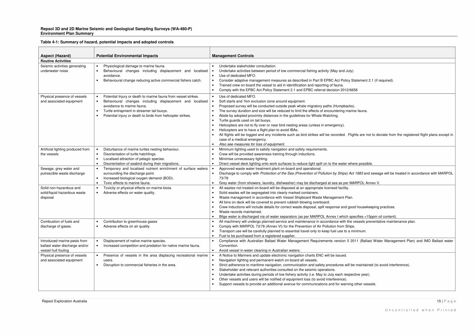
Table 4-1 below summarise the routine and non-routine aspects or hazards of the seismic campaign,
which may have potential environment impacts. Controls are adopted to mitigate the risk of impacts
to as low as reasonably practicable (ALARP) and to an acceptable level.
Repsol 3D and 2D Marine Seismic and Geological Sampling Surveys (WA-480-P) Environment Plan Summary
Repsol Exploration Australia 15 | P a g e
U n c o n t r o l l e d w h e n P r i n t e d
Table 4-1: Summary of hazard, potential impacts and adopted controls
Aspect (Hazard) Potential Environmental Impacts Management Controls
Routine Activities
Seismic activities generating
underwater noise
• Physiological damage to marine fauna.
• Behavioural changes including displacement and localised
avoidance.
• Behavioural change reducing active commercial fishers catch.
• Undertake stakeholder consultation.
• Undertake activities between period of low commercial fishing activity (May and July).
• Use of dedicated MFO.
• Consider adaptive management measures as described in Part B EPBC Act Policy Statement 2.1 (if required).
• Trained crew on board the vessel to aid in identification and reporting of fauna.
• Comply with the EPBC Act Policy Statement 2.1 and EPBC referral decision 2012/6658
Physical presence of vessels
and associated equipment
• Potential Injury or death to marine fauna from vessel strikes.
• Behavioural changes including displacement and localised
avoidance to marine fauna.
• Turtle entrapment in streamer tail buoys.
• Potential injury or death to birds from helicopter strikes.
• Use of dedicated MFO.
• Soft starts and 1km exclusion zone around equipment.
• Proposed survey will be conducted outside peak whale migratory paths (Humpbacks).
• The survey duration and size will be reduced to limit the effects of encountering marine fauna.
• Abide by adopted proximity distances in the guidelines for Whale Watching.
• Turtle guards used on tail buoys.
• Helicopters are not to fly over or near bird nesting areas (unless in emergency).
• Helicopters are to have a flight plan to avoid IBAs.
• All flights will be logged and any incidents such as bird strikes will be recorded. Flights are not to deviate from the registered flight plans except in
case of a medical emergency.
• Also see measures for loss of equipment.
Artificial lighting produced from
the vessels
• Disturbance of marine turtles nesting behaviour.
• Disorientation of turtle hatchlings.
• Localised attraction of pelagic species.
• Disorientation of seabird during their migrations.
• Minimum lighting used to satisfy navigation and safety requirements.
• Crew will be provided awareness training through inductions.
• Minimise unnecessary lighting.
• Direct vessel deck lighting onto work surfaces to reduce light spill on to the water where possible.
Sewage, grey water and
putrescible waste discharge
• Temporary and localised nutrient enrichment of surface waters
surrounding the discharge point.
• Increased biological oxygen demand (BOD).
• Toxic effects to marine fauna.
• Approved waste water treatment plant on-board and operational.
• Discharge to comply with Protection of the Sea (Prevention of Pollution by Ships) Act 1983 and sewage will be treated in accordance with MARPOL
73/78
• Grey water (from showers, laundry, dishwasher) may be discharged at sea as per MARPOL Annex V.
Solid non-hazardous and
solid/liquid hazardous waste
disposal
• Toxicity or physical effects on marine biota.
• Adverse effects on water quality.
• All wastes not treated on-board will be disposed at an appropriate licensed facility.
• Solid wastes will be segregated into clearly marked containers.
• Waste management in accordance with Vessel Shipboard Waste Management Plan.
• All bins on deck will be covered to prevent rubbish blowing overboard.
• Crew inductions will include details for correct waste disposal, spill response and good housekeeping practices.
• Waste records maintained.
• Bilge water is discharged via oil water separators (as per MARPOL Annex I which specifies <15ppm oil content).
Combustion of fuels and
discharge of gases.
• Contribution to greenhouse gases
• Adverse effects on air quality
• All machinery will undergo planned service and maintenance in accordance with the vessels preventative maintenance plan.
• Comply with MARPOL 73/78 (Annex VI) for the Prevention of Air Pollution from Ships.
• Transport use will be carefully planned to essential travel only to keep fuel use to a minimum.
• Fuel to be purchased from a registered supplier.
Introduced marine pests from
ballast water discharge and/or
vessel hull fouling
• Displacement of native marine species.
• Increased competition and predation for native marine fauna.
• Compliance with Australian Ballast Water Management Requirements version 5 2011 (Ballast Water Management Plan) and IMO Ballast water
Convention.
• Avoid vessel in-water cleaning in Australian waters.
Physical presence of vessels
and associated equipment
• Presence of vessels in the area displacing recreational marine
users.
• Disruption to commercial fisheries in the area.
• A Notice to Mariners and update electronic navigation charts ENC will be issued.
• Navigation lighting and permanent watch on-board all vessels.
• Strict adherence to maritime navigation, communication and safety procedures will be maintained (to avoid interference).
• Stakeholder and relevant authorities consulted on the seismic operations.
• Undertake activities during periods of low fishery activity (i.e. May to July each respective year).
• Other vessels and users will be notified of equipment loss (to avoid interference).
• Support vessels to provide an additional avenue for communications and for warning other vessels.

Repsol 3D and 2D Marine Seismic and Geological Sampling Surveys (WA-480-P) Environment Plan Summary
Repsol Exploration Australia 16 | P a g e
U n c o n t r o l l e d w h e n P r i n t e d
Aspect (Hazard) Potential Environmental Impacts Management Controls
Drop coring • Damage to existing sea bed infrastructure i.e. JASURUS cable.
• Impact to sea bed and benthic fauna.
• Careful planning of coring program (to avoid JASURUS cable).
• Approval of coring locations with Telstra.
• Prompt equipment recovery to avoid dragging corers across the sea bed.
• The impact footprint is limited to the size of the core and equipment with limited compaction.
Shipping traffic and seismic
equipment
• Disruption to shipping activities (not collision). • A Notice to Mariners and update ENC will be issued.
• Navigation lighting and permanent watch on-board all vessels.
• Strict adherence to maritime navigation, communication and safety procedures will be maintained (to avoid interference).
• Stakeholder and relevant authorities consulted on the seismic operation.
• Other vessels and users will be notified of equipment loss (to avoid interference).
• 1km Safety Exclusion Zone around the seismic vessel and all trailing seismic equipment.
• Support vessels to provide an additional avenue for communications and for warning other vessels and for protecting the seismic vessel and towed
equipment from vessel collision.
Non-routine activities
Vessel collision resulting in fuel
spill to the environment
• Acute toxicity or physical effects on marine fauna.
• Injury or death of marine fauna resulting from poisoning or
suffocation.
• Reduced water quality.
• Impact to protected areas, fisheries and tourism.
• Vessels to be equipped with navigational aids, radar, vessel GPS tracking, qualified crew, vessel management systems, depth sounders.
• All vessels to have a current and approved Shipboard Oil Pollution Emergency Plan (SOPEP).
• Strict adherence to maritime navigation, communication and safety procedures will be maintained (to avoid collision).
• Liaise with the port authorities and shipping agents in Port Hedland and Dampier.
• Notify AMSA and NOPSEMA in case of spills.
• A Notice to Mariners and update ENC will be issued.
• Spill contingency response implemented consistent with the EP.
• 1km Safety Exclusion Zone around the seismic vessel and all trailing seismic equipment.
• Support vessels to provide an additional avenue for communications and for warning other vessels and for protecting the seismic vessel and towed
equipment from vessel collision.
• The seismic vessels will have ENC and fuel management systems.
• Only contractors that use Marine Gas Oil (MGO) as opposed to Heavy Fuel Oil (HFO) will be chosen.
Accidental hydrocarbon or
chemical spill
• Acute toxicity or physical effects on marine fauna.
• Injury or death of marine fauna resulting from poisoning or
suffocation.
• Reduced water quality.
• Impact to protected areas, fisheries and tourism.
• Bunkering to be carried out in accordance with vessel specifications for bunkering (fuel storage and handling plan); transfer records maintained in
‘bunker note’.
• Transfer hose fitted with ‘dry break’ couplings and tested prior to refueling.
• Continuous monitoring of the transfer hose, pressure and flow rates during refueling (radio contact).
• Constant communication with the vessel master during refueling (radio contact).
• Harmful substances shall be properly stowed and secured so as to minimise the hazards to the marine environment without impairing safety
(includes fuels stored in accordance with vessels fuel storage and handling plan).
• Only contractors that use MGO as opposed to HFO will be chosen.
• Personnel trained in oil spill response.
• Implement SOPEP and Emergency Spill Response Plan (spill incident).
• Tools and resources available to cleanup spills consistent with SOPEP.
• Spill contingency response implemented consistent with the EP.
Loss of equipment • Potential hazard to commercial fishing, shipping from floating
debris.
• Toxicity from equipment.
• Impact to Marine fauna due to entanglement.
• 1km Safety Exclusion Zone around the seismic vessel and all trailing seismic equipment.
• Support vessels to provide an additional avenue for communications and for warning other vessels and for protecting the seismic vessel and towed
equipment from vessel collision.
• Deployment and recovery of streamers handled in accordance with vessel specific procedure (to reduce damage risk).
• Notification to other vessels in area of loss of equipment.
• Only solid streamers with no buoyancy aiding mixtures will be used.
• Only coring providers using steel core weights, as opposed to lead core weights will be used.
• If loss of equipment or streamers occurs, these will be retrieved as soon as possible.
Unplanned waste discharges
including hazardous, solid or
liquid waste (sewage, ballast
water etc.)
• Localised reduction in water quality.
• Impacts to marine fauna.
• The introduction of marine pests.
• Waste management in accordance with Vessel Shipboard Waste Management Plan.
• Harmful substances shall be properly stowed and secured so as to minimise the hazards to the marine environment without impairing safety.
• Crew inductions will include details for correct waste disposal, spill response and good housekeeping practices.
Repsol 3D and 2D Marine Seismic and Geological Sampling Surveys (WA-480-P) Environment Plan Summary
Repsol Exploration Australia 17 | P a g e
U n c o n t r o l l e d w h e n P r i n t e d
5. MANAGEMENT APPROACH
The proposed seismic activities will be conducted in accordance with Repsol’s HSE Management
System and this EP.
These control measures will be implemented through:
• the existing plans and procedures contained within Repsol’s HSE Management system; and/or
• development and inclusion of project specific plans, procedures and measures.
The key existing documents contained within Repsol’s HSE Management System include the
following:
• Exhibit E (Marine) HSE (herein called Repsol’s geophysical HSE requirements);
• Waste management environmental standard (MACOR_N01) (copies can be provided upon
request);
• Emergency Management (MACOR G-06) (copies can be provided upon request)
• HSE Manual (copies can be provided upon request);
• Vessels refuelling procedures (copies can be provided upon request);
• Vessel Shipboards Waste Management Plan (copies can be provided upon request);
• Ship Oil pollution Emergency Plan (SOPEP) (copies can be provided upon request); and
• Vessel Emergency Response Plan (ERP) (copies can be provided upon request).
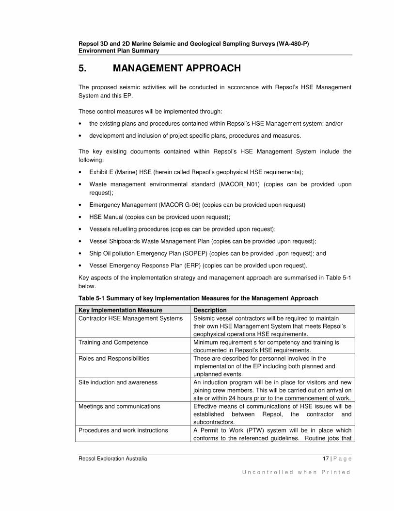
Key aspects of the implementation strategy and management approach are summarised in Table 5-1
below.
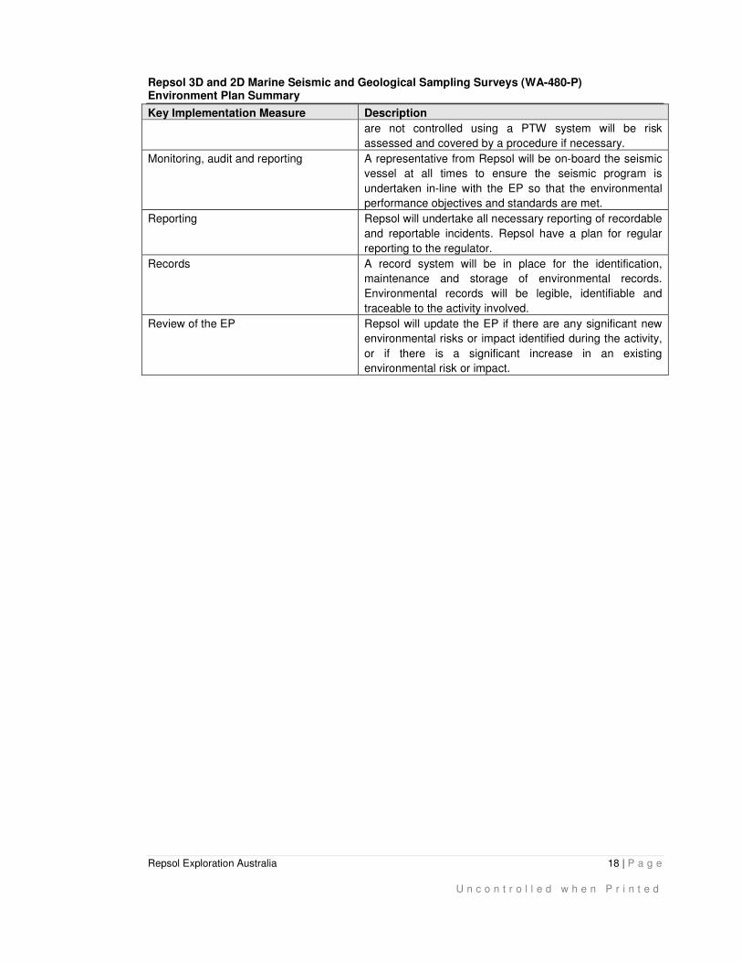
Table 5-1 Summary of key Implementation Measures for the Management Approach
Key Implementation Measure Description
Contractor HSE Management Systems
Seismic vessel contractors will be required to maintain
their own HSE Management System that meets Repsol’s
geophysical operations HSE requirements.
Training and Competence
Minimum requirement s for competency and training is
documented in Repsol’s HSE requirements.
Roles and Responsibilities These are described for personnel involved in the
implementation of the EP including both planned and
unplanned events.
Site induction and awareness
An induction program will be in place for visitors and new
joining crew members. This will be carried out on arrival on
site or within 24 hours prior to the commencement of work.
Meetings and communications Effective means of communications of HSE issues will be
established between Repsol, the contractor and
subcontractors.
Procedures and work instructions
A Permit to Work (PTW) system will be in place which
conforms to the referenced guidelines. Routine jobs that
Repsol 3D and 2D Marine Seismic and Geological Sampling Surveys (WA-480-P) Environment Plan Summary
Repsol Exploration Australia 18 | P a g e
U n c o n t r o l l e d w h e n P r i n t e d
Key Implementation Measure Description
are not controlled using a PTW system will be risk
assessed and covered by a procedure if necessary.
Monitoring, audit and reporting
A representative from Repsol will be on-board the seismic
vessel at all times to ensure the seismic program is
undertaken in-line with the EP so that the environmental
performance objectives and standards are met.
Reporting Repsol will undertake all necessary reporting of recordable
and reportable incidents. Repsol have a plan for regular
reporting to the regulator.
Records A record system will be in place for the identification,
maintenance and storage of environmental records.
Environmental records will be legible, identifiable and
traceable to the activity involved.
Review of the EP Repsol will update the EP if there are any significant new
environmental risks or impact identified during the activity,
or if there is a significant increase in an existing
environmental risk or impact.
Repsol 3D and 2D Marine Seismic and Geological Sampling Surveys (WA-480-P) Environment Plan Summary
Repsol Exploration Australia 19 | P a g e
U n c o n t r o l l e d w h e n P r i n t e d
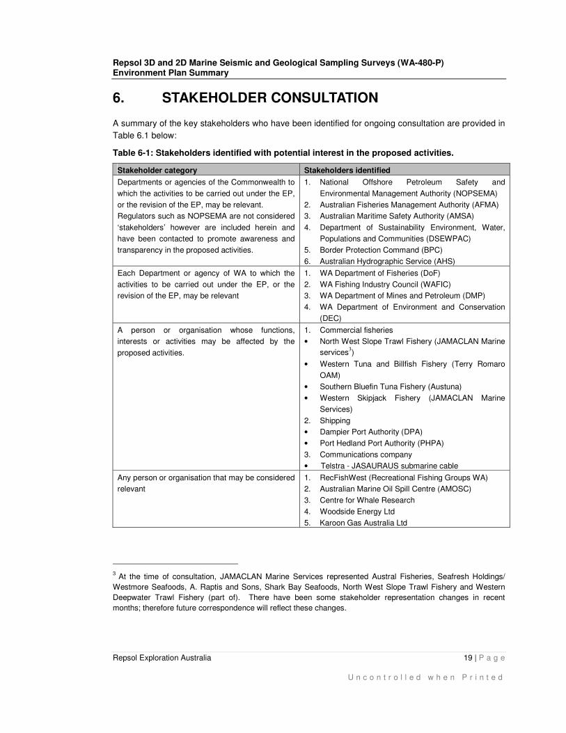
6. STAKEHOLDER CONSULTATION
A summary of the key stakeholders who have been identified for ongoing consultation are provided in
Table 6.1 below:
Table 6-1: Stakeholders identified with potential interest in the proposed activities.
Stakeholder category Stakeholders identified
Departments or agencies of the Commonwealth to
which the activities to be carried out under the EP,
or the revision of the EP, may be relevant.
Regulators such as NOPSEMA are not considered
‘stakeholders’ however are included herein and
have been contacted to promote awareness and
transparency in the proposed activities.
1. National Offshore Petroleum Safety and
Environmental Management Authority (NOPSEMA)
2. Australian Fisheries Management Authority (AFMA)
3. Australian Maritime Safety Authority (AMSA)
4. Department of Sustainability Environment, Water,
Populations and Communities (DSEWPAC)
5. Border Protection Command (BPC)
6. Australian Hydrographic Service (AHS)
Each Department or agency of WA to which the
activities to be carried out under the EP, or the
revision of the EP, may be relevant
1. WA Department of Fisheries (DoF)
2. WA Fishing Industry Council (WAFIC)
3. WA Department of Mines and Petroleum (DMP)
4. WA Department of Environment and Conservation
(DEC)
A person or organisation whose functions,
interests or activities may be affected by the
proposed activities.
1. Commercial fisheries
• North West Slope Trawl Fishery (JAMACLAN Marine
services3)
• Western Tuna and Billfish Fishery (Terry Romaro
OAM)
• Southern Bluefin Tuna Fishery (Austuna)
• Western Skipjack Fishery (JAMACLAN Marine
Services)
2. Shipping
• Dampier Port Authority (DPA)
• Port Hedland Port Authority (PHPA)
3. Communications company
• Telstra - JASAURAUS submarine cable
Any person or organisation that may be considered
relevant
1. RecFishWest (Recreational Fishing Groups WA)
2. Australian Marine Oil Spill Centre (AMOSC)
3. Centre for Whale Research
4. Woodside Energy Ltd
5. Karoon Gas Australia Ltd
3
At the time of consultation, JAMACLAN Marine Services represented Austral Fisheries, Seafresh Holdings/
Westmore Seafoods, A. Raptis and Sons, Shark Bay Seafoods, North West Slope Trawl Fishery and Western
Deepwater Trawl Fishery (part of). There have been some stakeholder representation changes in recent
months; therefore future correspondence will reflect these changes.

Repsol 3D and 2D Marine Seismic and Geological Sampling Surveys (WA-480-P) Environment Plan Summary
Repsol Exploration Australia 20 | P a g e
U n c o n t r o l l e d w h e n P r i n t e d
As required under the OPGGS(E)R, early stakeholder consultation has been undertaken
(commenced in November 2012). Repsol has identified several key areas of interest for stakeholder
consultation for the seismic campaign; these include shipping (navigation), oil and gas exploration
and production activities, telecommunications infrastructure and fishing.
Repsol understands stakeholder consultation is an ongoing process. All stakeholders with key
interests will be kept up-to-date with the proposed activities including details of any aspects of the
survey or changes that may affect other users. In the unlikely event any correspondence results in a
change in risks profile or change in the proposed activity, Repsol will review and notify NOPSEMA (if
required) for determination if the change constitutes a revision of the EP under Regulation 17 of
OPGGS(E)R.
Repsol 3D and 2D Marine Seismic and Geological Sampling Surveys (WA-480-P) Environment Plan Summary
Repsol Exploration Australia 21 | P a g e
U n c o n t r o l l e d w h e n P r i n t e d
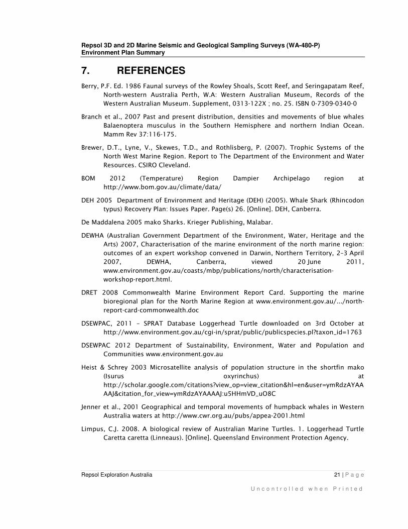
7. REFERENCES
Berry, P.F. Ed. 1986 Faunal surveys of the Rowley Shoals, Scott Reef, and Seringapatam Reef,
North-western Australia Perth, W.A: Western Australian Museum, Records of the
Western Australian Museum. Supplement, 0313-122X ; no. 25. ISBN 0-7309-0340-0
Branch et al., 2007 Past and present distribution, densities and movements of blue whales
Balaenoptera musculus in the Southern Hemisphere and northern Indian Ocean.
Mamm Rev 37:116-175.
Brewer, D.T., Lyne, V., Skewes, T.D., and Rothlisberg, P. (2007). Trophic Systems of the
North West Marine Region. Report to The Department of the Environment and Water
Resources. CSIRO Cleveland.
BOM 2012 (Temperature) Region Dampier Archipelago region at
http://www.bom.gov.au/climate/data/
DEH 2005 Department of Environment and Heritage (DEH) (2005). Whale Shark (Rhincodon
typus) Recovery Plan: Issues Paper. Page(s) 26. [Online]. DEH, Canberra.
De Maddalena 2005 mako Sharks. Krieger Publishing, Malabar.
DEWHA (Australian Government Department of the Environment, Water, Heritage and the
Arts) 2007, Characterisation of the marine environment of the north marine region:
outcomes of an expert workshop convened in Darwin, Northern Territory, 2–3 April
2007, DEWHA, Canberra, viewed 20 June 2011,
www.environment.gov.au/coasts/mbp/publications/north/characterisation-
workshop-report.html.
DRET 2008 Commonwealth Marine Environment Report Card. Supporting the marine
bioregional plan for the North Marine Region at www.environment.gov.au/.../north-
report-card-commonwealth.doc
DSEWPAC, 2011 – SPRAT Database Loggerhead Turtle downloaded on 3rd October at
http://www.environment.gov.au/cgi-in/sprat/public/publicspecies.pl?taxon_id=1763
DSEWPAC 2012 Department of Sustainability, Environment, Water and Population and
Communities www.environment.gov.au
Heist & Schrey 2003 Microsatellite analysis of population structure in the shortfin mako
(Isurus oxyrinchus) at
http://scholar.google.com/citations?view_op=view_citation&hl=en&user=ymRdzAYAA
AAJ&citation_for_view=ymRdzAYAAAAJ:u5HHmVD_uO8C
Jenner et al., 2001 Geographical and temporal movements of humpback whales in Western
Australia waters at http://www.cwr.org.au/pubs/appea-2001.html
Limpus, C.J. 2008. A biological review of Australian Marine Turtles. 1. Loggerhead Turtle
Caretta caretta (Linneaus). [Online]. Queensland Environment Protection Agency.

Repsol 3D and 2D Marine Seismic and Geological Sampling Surveys (WA-480-P) Environment Plan Summary
Repsol Exploration Australia 22 | P a g e
U n c o n t r o l l e d w h e n P r i n t e d
Limpus, C. 2009. A biological review of Australian marine turtle species. The State of
Queensland. Environmental Protection Agency.
Pendoley, K. 1997. "Sea turtles and management of marine seismic programs Western
Australia." PESA Journal 25.