Embed Size (px)
Citation preview

Request For Proposal
Vol-III
For
Construction of 69 Bridges
including Approach Roads
on the Tamu-Kyigone-Kalewa Road Section
from Km. 0.00 to Km. 149.70 of the
Trilateral Highway in Myanmar
on
Engineering, Procurement & Construction Mode
FEASIBILITY REPORT
MINSTRY OF EXTERNAL AFFAIRS
NEW DELHI
April, 2017

KD5 :Final Feasibility Report including Schedules
Consultancy Services for Preparation of Feasibility Report for Construction of Bridges including Approaches on Tamu – Kyigone – Kalewa Road Section from km 0.00 to km 149.70 in Myanmar
MEA i
TABLE OF CONTENTS
Sl. No.
Description Page Nos.
0. EXECUTIVE SUMMARY 0-1 to 0-16
1. INTRODUCTION 1-1 to 1-3
1.1 Background 1-1
1.2 Objective 1-1
2. PROJECT DESCRIPTION 2-1 to 2-4
2.1 Introduction 2-1
2.2 Project Description 2-1
2.3 Study of Existing Alignment 2-2
2.3.1 Existing Carriageway 2-2
2.3.2 Existing Horizontal and Vertical Profile 2-2
2.3.3 Right of Way 2-3
2.3.4 Current Development Activities 2-3
2.3.5 Details of Bridges and Culverts 2-4
3. SOCIO ECONOMIC PROFILE 3-1 to 3-14
3.1 General 3-1
3.2 Project Road 3-1
3.3 Geology 3-2
3.4 River/Streams/Water Courses 3-2
3.5 Climate 3-3
3.6 Socio Economic Profile 3-3
4. ENGINEERING SURVEYS AND INVESTIGATIONS 4-1 to 4-39
4.1 General 4-1
4.2 Topographical Survey 4-1
4.2.1 Introduction 4-1
4.2.2 Objective 4-1
4.2.3 Scope of Work 4-1
4.2.4 General Terrain 4-2
4.2.5 Methodology 4-2
4.2.5 .1 Establishment of Main Control by DGPS 4-2
4.2.5 .2 Detailed Topographical Survey 4-6

KD5 :Final Feasibility Report including Schedules
Consultancy Services for Preparation of Feasibility Report for Construction of Bridges including Approaches on Tamu – Kyigone – Kalewa Road Section from km 0.00 to km 149.70 in Myanmar
MEA ii
Sl. No. Description Page Nos.
4.2.6 Data Processing 4-7
4.2.7 Feature Codes 4-7
4.2.8 Quality Control 4-7
4.3 Bridge/Structure Inventory 4-8
4.3.1 General 4-8
4.3.2 Secondary data 4-8
4.3.3 Field Surveys 4-8
4.4 Culvert Inventory 4-16
4.5 Road Inventory Surveys 4-16
4.6 Hydrology and Drainage 4-17
4.6.1 Introduction 4-17
4.6.2 Reconnaissance Survey 4-17
4.6.3 Hydraulic Performance of Existing Bridges 4-17
4.7 Traffic Surveys and Analysis 4-17
4.7.1 Traffic Surveys 4-17
4.7.2 Traffic Characteristics 4-20
4.7.3 Vehicle Damage Factor 4-26
4.7.4 Traffic Growth Rate Estimation 4.26
4.7.5 Traffic Volume Projections 4-30
4.8 Pavement Investigations 4-33
4.8.1 General 4-33
4.8.2 Adopted Methodology for Feasibility Study 4-33
4.9 Soil and Material Investigation 4-34
4.9.1 General 4-34
4.9.2 Subgrade Soil 4-34
4.9.3 Borrow Area for Soils 4-35
4.9.4 Stone Metal Quarries 4-37
4.10 Geo Technical Investigations 4-39
5. DESIGN STANDARDS AND PROPOSED CROSS SECTION 5-1 to 5-40
5.1 General Considerations for Road/Bridge Approaches 5-1
5.2 Proposed Typical Cross Sections 5-4

KD5 :Final Feasibility Report including Schedules
Consultancy Services for Preparation of Feasibility Report for Construction of Bridges including Approaches on Tamu – Kyigone – Kalewa Road Section from km 0.00 to km 149.70 in Myanmar
MEA iii
Sl. No. Description Page Nos.
5.3 Design Codes and Standards 5-17
5.4 Design Standards for Roads 5-18
5.4.1 Horizontal Alignment 5-18
5.4.2 Vertical Alignment 5-18
5.4.3 Road Embankment 5-19
5.4.4 Road Safety Devices 5-19
5.5 Design Standards for Bridges 5-20
5.5.1 Material 5-20
5.5.2 Design Methodology 5-22
5.5.3 Seismic Design and Detailing 5-24
5.5.4 Bearings 5-30
5.5.5 Loading 5-31
5.5.6 Cover 5-32
5.5.7 Minimum Diameter of bar 5-32
5.5.8 Bridge Furniture Details 5-32
5.5.9 Expansion Joints 5-35
5.5.10 Wearing Course 5-36
5.5.11 Edge Treatment 5-36
5.5.12 Drainage spouts 5-37
5.5.13 Protection Works 5-37
5.6 Approaches 5-39
5.7 Lamp post Fixtures 5-39
5.7.1 Fixtures Details 5-39
5.7.2 Utilities 5-39
5.7.3 Approach Slab 5-39
6. IMPROVEMENT PROPOSALS AND PRELIMINARY DESIGN 6-1 to 6-48
6.1 General 6-1
6.2 Alignment Proposal 6-2
6.3 Cross Section of Bridges and Bridge Approach 6-3
6-4 Structure Design 6-12
6.4.1 Structure Proposal 6-12

KD5 :Final Feasibility Report including Schedules
Consultancy Services for Preparation of Feasibility Report for Construction of Bridges including Approaches on Tamu – Kyigone – Kalewa Road Section from km 0.00 to km 149.70 in Myanmar
MEA iv
Sl. No. Description Page Nos.
6.4.2 PSC Girder Superstructures 6-13
6.4.3 RC Girder Superstructures 6-13
6.4.4 RC Substructures 6-13
6.4.5 Foundation 6-13
6.4.6 RC Crash Barriers 6-13
6.4.7 Expansion Joints 6-13
6.4.8 Wearing Coat 6-13
6.4.9 Drainage Spouts 6-13
6.4.10 Approach Slab 6-13
6.4.11 Concrete Grades 6-14
6.4.12 Reinforcement 6-14
6.4.13 Bearings 6-14
6.4.14 Protection Works 6-14
6.4.15 Proposed Major Bridges 6-15
6.4.16 Proposed Minor Bridges 6-16
6.4.17 Details of Minor Bridges for Reconstruction 6-20
6.4.18 Details of Bridges under Construction 6-20
6.4.19 Culverts 6-21
6.4.20 New Culverts 6-23
6.5 Geo metric Design 6-23
6.5.1 Horizontal Alignment 6-23
6.5.2 Vertical/Gradient 6-23
6.6 Pavement Design 6-38
6.6.1 General 6-38
6.6.2 Factor considered for Pavement Design 6-38
6.6.3 Design Period 6-39
6.6.4 Design Traffic 6-40
6.6.5 Characteristics of Subgrade Soil 6-40
6.6.6 Design of Flexible Pavement 6-40
6.6.7 Design of Shoulders 6-40
6.7 Roadside Drainage Design 6-41
KD5 :Final Feasibility Report including Schedules
Consultancy Services for Preparation of Feasibility Report for Construction of Bridges including Approaches on Tamu – Kyigone – Kalewa Road Section from km 0.00 to km 149.70 in Myanmar
MEA v
Sl. No. Description Page Nos.
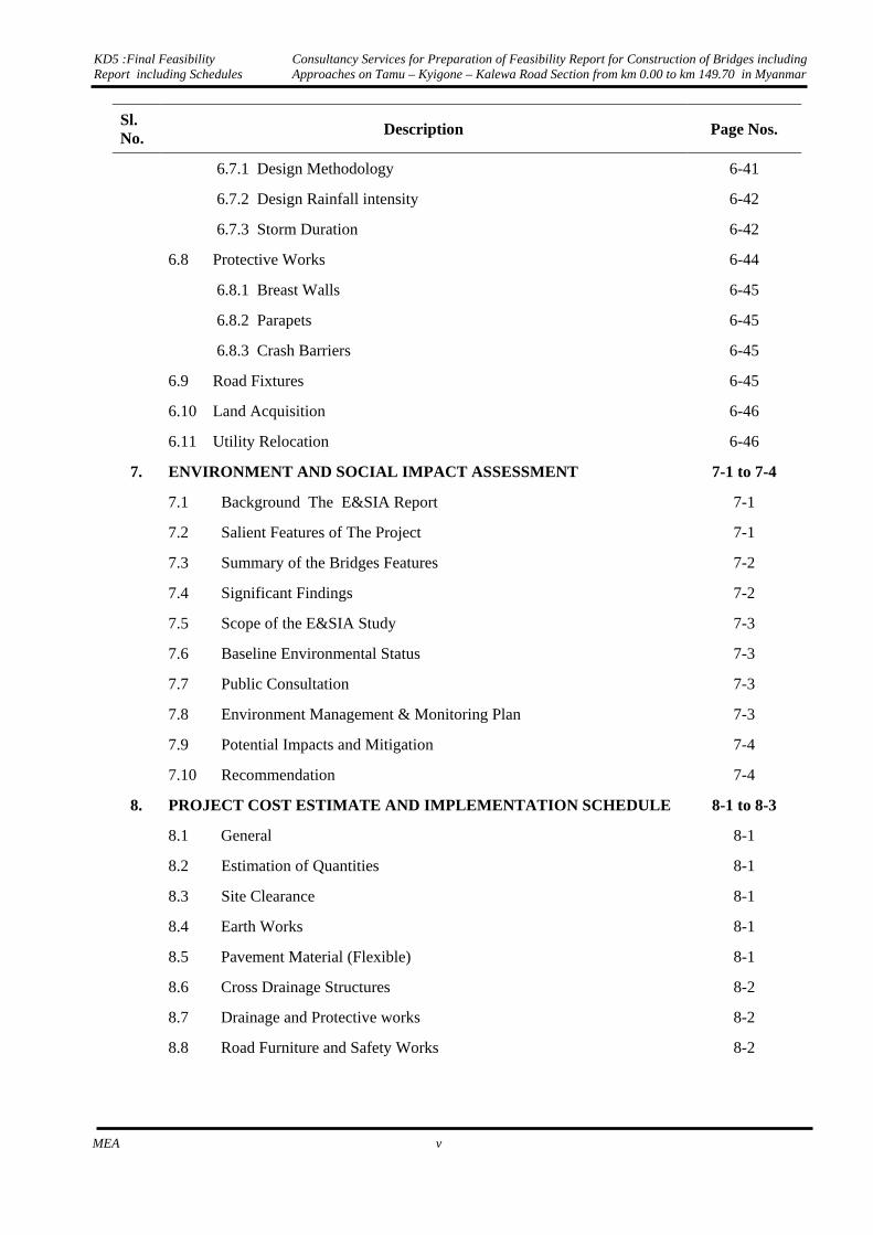
6.7.1 Design Methodology 6-41
6.7.2 Design Rainfall intensity 6-42
6.7.3 Storm Duration 6-42
6.8 Protective Works 6-44
6.8.1 Breast Walls 6-45
6.8.2 Parapets 6-45
6.8.3 Crash Barriers 6-45
6.9 Road Fixtures 6-45
6.10 Land Acquisition 6-46
6.11 Utility Relocation 6-46
7. ENVIRONMENT AND SOCIAL IMPACT ASSESSMENT 7-1 to 7-4
7.1 Background The E&SIA Report 7-1
7.2 Salient Features of The Project 7-1
7.3 Summary of the Bridges Features 7-2
7.4 Significant Findings 7-2
7.5 Scope of the E&SIA Study 7-3
7.6 Baseline Environmental Status 7-3
7.7 Public Consultation 7-3
7.8 Environment Management & Monitoring Plan 7-3
7.9 Potential Impacts and Mitigation 7-4
7.10 Recommendation 7-4
8. PROJECT COST ESTIMATE AND IMPLEMENTATION SCHEDULE 8-1 to 8-3
8.1 General 8-1
8.2 Estimation of Quantities 8-1
8.3 Site Clearance 8-1
8.4 Earth Works 8-1
8.5 Pavement Material (Flexible) 8-1
8.6 Cross Drainage Structures 8-2
8.7 Drainage and Protective works 8-2
8.8 Road Furniture and Safety Works 8-2

KD5 :Final Feasibility Report including Schedules
Consultancy Services for Preparation of Feasibility Report for Construction of Bridges including Approaches on Tamu – Kyigone – Kalewa Road Section from km 0.00 to km 149.70 in Myanmar
MEA vi
LIST OF TABLES
Sl. No.
Description Page Nos.
3.1 List of Settlement/Villages along the Project Road 3-1
3.2 Population Growth Rate 3-4
3.3 State-wise Population for the last three years 3-4
3.4 GDP Growth Rate for various years 3-6
4.1 GPS Pillars Detail 4-3
4.2 Details of Existing Bridges 4-8
4.3 Homogeneous Sections of Project road 4-18
4.4 Traffic Survey Schedule 4-19
4.5 Vehicle Classification Systems 4-20
4.6 Average Daily Traffic (ADT) at Survey locations 4-21
4.7 Observed Peak Hour Traffic Characteristics 4-21
4.8 Directional distribution (in PCU) on Project road (%) 4-22
4.9 Traffic Composition at surveyed locations (%) 4-25
4.10 AADT for the Project Road 4-26
4.11 VDF at Survey Locations 4-26
4.12 Registered Vehicle in Myanmar 4-27
4.13 GDP Growth for Myanmar 4-28
4.14 Traffic Growth Rates for Project road 4-29
4.15 Traffic Estimation for proposed Integrated Check Posts as estimated by RITES
4-30
4.16 Growth Rates for proposed Integrated Check Posts estimated by RITES
4-30
4.17 Traffic Projection for Section (HS-I) Km 0.000 to Km 121.690 4-31
4.18 Traffic Projection for Section (HS-I) Km 121.690 to Km 149.700 4-32
4.19 Summary of Grain Size Analysis for Subgrade Soil 4-34
4.20 Summary of Atterberg Limits for the Subgrade 4-35
4.21 CBR for the Subgrade Soil 4-35
5.1 Design Standards 5-1
5.2 Geometric Design Standard for Highways, Myanmar 5-3
5.3 Type of Expansion Joints 5-35
6.1 Basic Data for Design 6-1

KD5 :Final Feasibility Report including Schedules
Consultancy Services for Preparation of Feasibility Report for Construction of Bridges including Approaches on Tamu – Kyigone – Kalewa Road Section from km 0.00 to km 149.70 in Myanmar
MEA vii
Sl. No. Description Page Nos.
6.2 Cross Section for Bridges 6-3
6.3 Details of Proposed applicable Cross Sections as per Design Chainage 6-3
6.4 Details of Bridges 6-15
6.5 Details of Major Bridges 6-15
6.6 Details of Minor Bridges 6-16
6.7 Details of Minor Bridges for Reconstruction 6-20
6.8 Details of Retained Minor Bridges 6-20
6.9 Details of Under Construction Bridges 6-21
6.10 Details of HP Culvert 6-21
6.11 Details of Arch Culvert 6-21
6.12 Details of Slab Culvert 6-21
6.13 Details of New Culvert 6-23
6.14 Details of Horizontal Alignments 6-24
6.15 Details of Vertical Alignments 6-32
6.16 Homogenous Traffic Sections 6-39
6.17 Vehicle Damage Factor for Project Road 6-39
6.18 Design Traffic for 15 years (after opening of traffic) 6-40
6.19 CBR values for Subgrade Materials 6-40
6.20 Pavement Composition for New Construction 6-41
6.21 Suggestive values of coefficient of Run -Off 6-42
6.22 Details of Retaining wall 6-45
6.23 Details of Breast Walls 6-45
6.24 Electric Pole required Relocation 6-47
7.1 List of Settlement /Villages along the Project Road 7-1
8.1 Project Cost Estimate 8-2

KD5 :Final Feasibility Report including Schedules
Consultancy Services for Preparation of Feasibility Report for Construction of Bridges including Approaches on Tamu – Kyigone – Kalewa Road Section from km 0.00 to km 149.70 in Myanmar
MEA viii
LIST OF FIGURES
Sl. No.
Description Page Nos.
1.1 Index Map 1-2
3.1 Location of Sagaing division in Myanmar 3-1
4.1 Project Road and Traffic Survey Location 4-19
4.2a Day wise Variation of Total Traffic on the Project Road at Km 12.500 4-22
4.2b Day wise Variation of Total Traffic on the Project Road at Km 122.500 4-22
4.3a Hourly variation of Traffic on Project Road at Km 12.500 4-23
4.3b Hourly variation of Traffic on Project Road at Km 122.500 4-23
4.4a Traffic Composition on Project Road at Km 12.500 4-24
4.4b Traffic Composition on Project Road at Km 122.500 4-24
4.5 Type of Soil 4-35
5.1 Section of Two lane Bridge with footpath (For Plain and Rolling Terrain) 5-6
5.2 Section of Two lane Bridge without footpath (For Plain and Rolling Terrain)
5-6
5.3 Section of Two lane Bridge without footpath (For Hilly Terrain) 5-6
5.4 Typical Cross-Section for 2 lane Bridge Approaches-Both side Fill Slope (For Plain and Rolling Terrain)
5-7
5.5 Typical Cross-section for 2 Lane Bridge Approaches-Both Side Cut (For Plain and Rolling Terrain)
5-8
5.6 Typical Cross-section for 2 Lane Bridge Approaches- Both side Fill Slope (For Hilly Terrain)
5-9
5.7 Typical Cross-section for 2 Lane Bridge Approaches-Left Side Cut & Right Side Fill Slope (For Hilly Terrain)
5-9
5.8 Typical Cross-section for 2 Lane Bridge Approaches-Both Side Cut (For Hilly Terrain)
5-10
5.9 Typical Cross-section for 2 Lane Bridge Approaches-Both Side Retaining Wall (For Hilly Terrain)
5-10
5.10 Typical Cross-section for 2 Lane Bridge Approaches-Left Side Fill Slope & Right Side Retaining Wall (For Hilly Terrain)
5-11
5.11 Typical Cross-section for 2 Lane Bridge Approaches-Left Side Retaining Wall & Right Side Cut (For Plain & Rolling Terrain)
5-11
5.12 Typical Cross-section for 2 Lane Bridge Approaches-Left Side Breast Wall & Right Side Retaining Wall (For Hilly Terrain)
5-12
5.13 Typical Cross-section for 2 Lane Bridge Approaches-Left Side Cut & Right Side Retaining Wall (For Hilly Terrain)
5-12

KD5 :Final Feasibility Report including Schedules
Consultancy Services for Preparation of Feasibility Report for Construction of Bridges including Approaches on Tamu – Kyigone – Kalewa Road Section from km 0.00 to km 149.70 in Myanmar
MEA ix
Sl. No. Description Page Nos.
5.14 Typical Cross-section for 2 Lane Bridge Approaches-Left Side Breast Wall & Right Side Fill Slope (For Hilly Terrain)
5-13
5.15 Typical Cross-section for 2 Lane Bridge Approaches-Left Side Fill Slope & Right Side Cut (For Plain & Rolling Terrain)
5-13
5.16 Typical Cross-section for 2 Lane Bridge Approaches-Left Side Retaining Wall & Right Side Fill Slope (For Plain & Rolling Terrain)
5-14
5.17 Typical Cross-section for 2 Lane Bridge Approaches-Left Side Retaining Wall & Right Side Fill Slope ( For Hilly Terrain)
5-14
5.18 Typical Cross-section for 2 Lane Bridge Approaches-Both Side Breast Wall (For Plain & Rolling Terrain)
5-15
5.19 Typical Cross-section for 2 Lane Bridge Approaches- Left Side Cut Slope Right Side Breast Wall (For Plain & Rolling Terrain)
5-15
5.20 Typical Cross-section for 2 Lane Bridge Approaches- Left Side Fill slope and Right side Retaining Wall (For Plain & Rolling Terrain)
5-16
5.21 Transverse Reinforcement in Column 5-28
5.22 Dimensional Details of Crash Barrier 5-33
5.23 Reinforcement Details of Crash Barrier 5-34
5.24 Details of Expansion Joints 5-35
5.25 Details of Edge Treatment 5-36
5.26 Typical Shape and Dimensional Details of Drainage Spouts 5-37
5.27 Details of Protection works 5-38
5.28 Dimensional Details of Approach Slab 5-39
5.29 Reinforcement Details of Approach Slab 5-40
6.1 CSA Growth over the Design Life of Pavement 6-40
KD5 :Final Feasibility Report including Schedules
Consultancy Services for Preparation of Feasibility Report for Construction of Bridges including Approaches on Tamu – Kyigone – Kalewa Road Section from km 0.00 to km 149.70 in Myanmar
MEA x
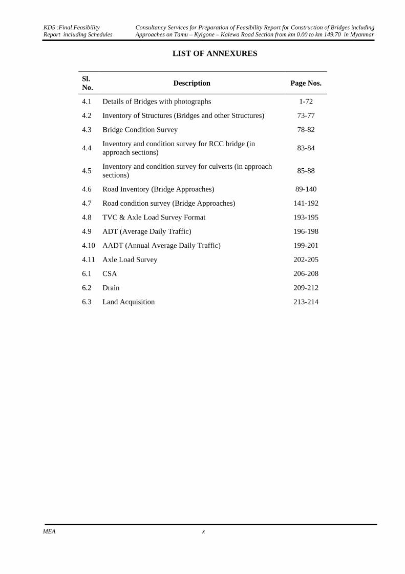
LIST OF ANNEXURES
Sl. No.
Description Page Nos.
4.1 Details of Bridges with photographs 1-72
4.2 Inventory of Structures (Bridges and other Structures) 73-77
4.3 Bridge Condition Survey 78-82
4.4 Inventory and condition survey for RCC bridge (in approach sections)
83-84
4.5 Inventory and condition survey for culverts (in approach sections)
85-88
4.6 Road Inventory (Bridge Approaches) 89-140
4.7 Road condition survey (Bridge Approaches) 141-192
4.8 TVC & Axle Load Survey Format 193-195
4.9 ADT (Average Daily Traffic) 196-198
4.10 AADT (Annual Average Daily Traffic) 199-201
4.11 Axle Load Survey 202-205
6.1 CSA 206-208
6.2 Drain 209-212
6.3 Land Acquisition 213-214

Executive Summary

KD5 :Final Feasibility Report including Schedules
Consultancy Services for Preparation of Feasibility Report for Construction of Bridges including Approaches on Tamu – Kyigone – Kalewa Road Section from km 0.00 to km 149.70 in Myanmar
MEA 0-1
EXECUTIVE SUMMARY
0.1 PROJECT DESCRIPTION
Tamu - Kyigone - Kalewa road is of intermediate lane width and passes through plain and hilly terrain. The road is generally in good condition except the bridges which are old steel bridges of single lane width and are proposed to be replaced by two lane wide bridges for Class 70 R loading
The project road starts at km 0.00 (93.0 milestone) at India Myanmar border near Tamu (Bridge no. 1) and ends at km 149.70 (0.0 milestone) at Kalewa.
The alignment from Km 0.000 to Km 121.690 i.e. between Tamu and Kyigone is passing through Plain and Rolling terrain. From Kyigone to Kalewa the project road is passing through hilly terrain. The land use observed along the alignment section is predominantly agriculture and open lands and some sections are passing through settlement areas along the road.
0.2 ENGINEERING SURVEYS AND INVESTIGATIONS
Based on the requirement enumerated in the terms of reference for “Preparation of Feasibility Report for Construction of Bridges including Approaches on Tamu – Kyigone – Kalewa Road Section from km 0.00 to km 149.70 in Myanmar” consultants had carried out engineering surveys and investigations as given below: • Topographical Survey • Road Inventory and Condition survey (for bridge approaches) • Inventory of 71 steel bridges • Inventory of culverts and other structures falling on bridge approaches • Pavement Condition Survey • Soil and Material investigations • Hydrology and Drainage Studies • Traffic Surveys and Analysis • Material Investigation • Geo-Technical Investigations
Topographical Survey
Detailed topographical survey of all natural and manmade topographical features has been carried out by picking up their x, y and z coordinates using Total Stations having automatic data recording devices with appropriate feature codes attached to each point. Survey corridor is 30m on either side of the center line of existing road.
In general, these include:
• Road center line. • Pavement edges. • Outer shoulder edges. • Toe lines of fills and cuts. • Longitudinal and transverse drains/ ditches. • Bridge locations and Details. • River Channel locations along with river cross-sections.
All man-made and natural topographical features were surveyed, including:

KD5 :Final Feasibility Report including Schedules
Consultancy Services for Preparation of Feasibility Report for Construction of Bridges including Approaches on Tamu – Kyigone – Kalewa Road Section from km 0.00 to km 149.70 in Myanmar
MEA 0-2
• Water sources, Ponds etc. • Culverts with their type and number • Electric and telephone lines • Huts, Buildings, fences, stairs, hand pumps, bore wells, wells • All Buildings were collected with suitable codes depending upon its classification like
residential, commercial, educational, health Center, industrial, religious etc. • Oil and gas pipe lines • All trees with girth greater than 0.3 meter.
At locations, where existing alignment cross other roads, the survey was extended to 100 to 200 m on either side of the road center to allow for the geometric improvements. Cross sections at every 50 m interval in flat terrain and at lesser interval on undulating terrain or horizontal curves were also taken using Total Stations.
Bridge/ Structures Inventory
Salient features of existing bridges such as name, location, span arrangement and other details are given in the below Table
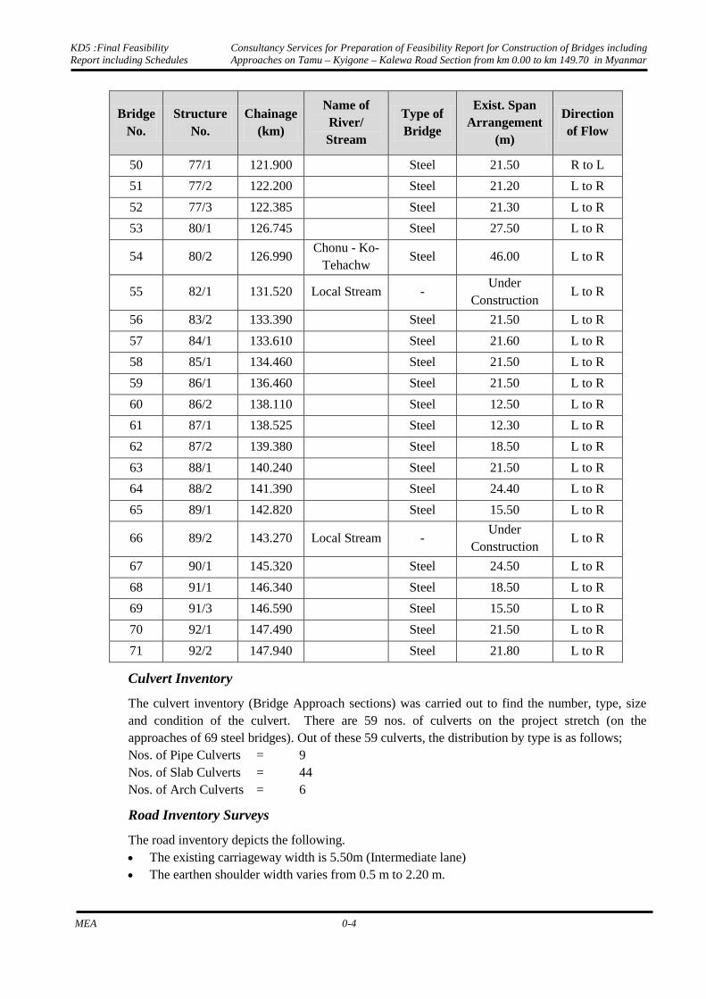
Details of Existing Bridges
BridgeNo.
Structure No.
Chainage (km)
Name of River/ Stream
Type of Bridge
Exist. Span Arrangement
(m)
Direction of Flow
1 1/1 0.030 Lokchao Steel 43.00 R to L
2 4/1 4.880 Luei Steel 36.60 R to L
3 7/1 10.880 Nanpalong Steel 27.50 R to L
4 8/1 12.000
Steel 18.30 R to L
5 9/1 13.740 Pantha Steel 2x15.4 R to L
6 10/2 15.760
Steel 12.20 R to L
7 12/1 18.240 Lallim Steel 17.8+27.8+27.5 R to L
8 13/2 19.575
Steel 19.40 R to L
9 15/1 22.470 Zaang
Lienphal Steel 27.50 R to L
10 16/2 25.130
Steel 15.30 R to L
11 18/1 27.290 Willou Stream
Steel 33.6+24.6 R to L
12 18/2 27.725
Steel 18.40 R to L
13 20/2 31.040 Nie-Ell-Kiaiz Steel 33.6+24.6 R to L
14 22/1 34.620 Tuivang Steel 28.0+16.8+19.5 R to L
15 24/1 36.930 Auhatung Steel 30.50 R to L
16 27/1 42.075
Steel 15.50 R to L
17 28/1 43.630 Hein-Zin Steel 30.5+30.5 R to L
18 32/1 49.510
Steel 18.40 R to L

KD5 :Final Feasibility Report including Schedules
Consultancy Services for Preparation of Feasibility Report for Construction of Bridges including Approaches on Tamu – Kyigone – Kalewa Road Section from km 0.00 to km 149.70 in Myanmar
MEA 0-3
BridgeNo.
Structure No.
Chainage (km)
Name of River/ Stream
Type of Bridge
Exist. Span Arrangement
(m)
Direction of Flow
19 32/2 49.850 Kanmagyi Steel 18.5+25+27.5+
24.7 R to L
20 34/1 53.850
Steel 2x27.70 R to L
21 34/2 54.150 Kannan Steel 9.2+21.2+21.4
+18.8+18.3 R to L
22 35/1 55.560 Khaupat Steel 18.5+23.3+22.5
+15.2 R to L
23 38/1 60.075
Steel 21.30 R to L
24 38/2 60.275
Steel 24.40 R to L
25 41/1 64.135
Steel 27.30 R to L
26 42/1 66.405
Steel 16.00 R to L
27 44/1 68.995
Steel 18.50 R to L
28 46/1 72.200
Steel 18.30 R to L
29 47/3 74.905 Saw-Bwu-Yayshin
Steel 21.8+12.5 R to L
30 48/1 75.325
Steel 24.50 R to L
31 51/1 81.085 Nankyathlaw Steel 24.50 L to R
32 57/1 89.990 Khonta-I Steel 39.60 L to R
33 57/2 90.870 Khonta-II Steel 35.00 L to R
34 57/3 91.215
Steel 18.50 L to R
35 58/1 92.505
Steel 15.80 L to R
36 58/2 92.755
Steel 19.10 L to R
37 60/1 94.845 Khonta-III Steel 43.50 L to R
38 61/1 96.165
Steel 24.60 L to R
39 61/2 96.525
Steel 18.30 L to R
40 61/3 97.610
Steel 24.50 L to R
41 62/1 98.880
Steel 25.30 L to R
42 62/2 99.205
Steel 16.20 L to R
43 63/1 99.575 Son - lar -
myaing Steel 34.50 L to R
44 64/1 101.425
Steel 16.20 L to R
45 67/1 106.260 Nanu - Hau -
Nwt Steel 15.5+25.0 L to R
46 68/1 107.290
Steel 18.60 L to R
47 68/2 107.930
Steel 25.30 L to R
48 71/1 112.320 Local Stream Steel 34.50 L to R
49 73/1 116.010
Steel 15.30 L to R
KD5 :Final Feasibility Report including Schedules
Consultancy Services for Preparation of Feasibility Report for Construction of Bridges including Approaches on Tamu – Kyigone – Kalewa Road Section from km 0.00 to km 149.70 in Myanmar
MEA 0-4
BridgeNo.
Structure No.
Chainage (km)
Name of River/ Stream
Type of Bridge
Exist. Span Arrangement
(m)
Direction of Flow
50 77/1 121.900
Steel 21.50 R to L
51 77/2 122.200
Steel 21.20 L to R
52 77/3 122.385
Steel 21.30 L to R
53 80/1 126.745
Steel 27.50 L to R
54 80/2 126.990 Chonu - Ko-
Tehachw Steel 46.00 L to R
55 82/1 131.520 Local Stream - Under
Construction L to R
56 83/2 133.390
Steel 21.50 L to R
57 84/1 133.610
Steel 21.60 L to R
58 85/1 134.460
Steel 21.50 L to R
59 86/1 136.460
Steel 21.50 L to R
60 86/2 138.110
Steel 12.50 L to R
61 87/1 138.525
Steel 12.30 L to R
62 87/2 139.380
Steel 18.50 L to R
63 88/1 140.240
Steel 21.50 L to R
64 88/2 141.390
Steel 24.40 L to R
65 89/1 142.820
Steel 15.50 L to R
66 89/2 143.270 Local Stream - Under
Construction L to R
67 90/1 145.320
Steel 24.50 L to R
68 91/1 146.340
Steel 18.50 L to R
69 91/3 146.590
Steel 15.50 L to R
70 92/1 147.490
Steel 21.50 L to R
71 92/2 147.940
Steel 21.80 L to R
Culvert Inventory
The culvert inventory (Bridge Approach sections) was carried out to find the number, type, size and condition of the culvert. There are 59 nos. of culverts on the project stretch (on the approaches of 69 steel bridges). Out of these 59 culverts, the distribution by type is as follows; Nos. of Pipe Culverts = 9 Nos. of Slab Culverts = 44 Nos. of Arch Culverts = 6
Road Inventory Surveys
The road inventory depicts the following. • The existing carriageway width is 5.50m (Intermediate lane) • The earthen shoulder width varies from 0.5 m to 2.20 m.

KD5 :Final Feasibility Report including Schedules
Consultancy Services for Preparation of Feasibility Report for Construction of Bridges including Approaches on Tamu – Kyigone – Kalewa Road Section from km 0.00 to km 149.70 in Myanmar
MEA 0-5
• In many sections horizontal alignment has S curves and sharp curves not conforming to IRC Standards.
• At many locations vertical curves not conforming to IRC standards. Frequent rise grades and fall grades has been observed in many section.
• Drainage along the stretch is predominantly non-existent except in hilly stretch where they are partially functional.
• Field observations, secondary data and Local inquiries indicated that some road stretches get submerged during heavy rains.
• There is no clear demarcation at site of the existing right of way more over there are encroachment at many places.
• The existing ROW varies from 30m to 70m all along the project highway.
Hydrology and drainage
As per local enquiry and visual inspection submergence was observed at 8 number of bridges. Detailed hydraulic calculations of all bridges has already been submitted in stage “KD3: Report on soil characteristics, sub-soil and hydraulic investigation, GAD for bridge and other structures”
Traffic Survey and Analysis
The traffic volume data collected during the surveys was averaged out to arrive at the average daily traffic (ADT) on the project road. The summaries of ADT in terms of vehicles and PCU for two count stations on project road are presented in below table.
Average Daily Traffic (ADT) at Survey locations
Mode Km 12.500 Km 122.500 Car/Jeep/Van 97 125
Two Wheeler 2159 1065
Auto Rickshaw 97 92
Bus Mini Bus 102 79
Bus 22 45
2 Axle Truck 54 86
3 Axle Truck 5 14
MAV 23 73 LCV 15 40
Agriculture Tractor
Tractor 9 23
Tractor with Trolley 0 0
Cycle 116 28
Cycle Rickshaw 5 1
Hand Cart 0 0
Animal/Hand Drawn 5 0
Total 2711 1671 PCUs 1907 1742
Pavement Investigations
Test pits were carried out at every 3 km (five bridge approaches) to check for the existing pavement composition. Based on the existing thickness of various pavement layers, strength of the existing pavement has been estimated.
KD5 :Final Feasibility Report including Schedules
Consultancy Services for Preparation of Feasibility Report for Construction of Bridges including Approaches on Tamu – Kyigone – Kalewa Road Section from km 0.00 to km 149.70 in Myanmar
MEA 0-6
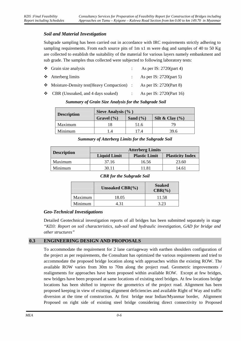
Soil and Material Investigation
Subgrade sampling has been carried out in accordance with IRC requirements strictly adhering to sampling requirements. From each source pits of 1m x1 m were dug and samples of 40 to 50 Kg are collected to establish the suitability of the material for various layers namely embankment and sub grade. The samples thus collected were subjected to following laboratory tests:
Grain size analysis : As per IS: 2720(part 4)
Atterberg limits : As per IS: 2720(part 5)
Moisture-Density test(Heavy Compaction) : As per IS: 2720(Part 8)
CBR (Unsoaked, and 4 days soaked) : As per IS: 2720(Part 16)
Summary of Grain Size Analysis for the Subgrade Soil
Description Sieve Analysis (% )
Gravel (%) Sand (%) Silt & Clay (%)
Maximum 18 51.6 79
Minimum 1.4 17.4 39.6
Summary of Atterberg Limits for the Subgrade Soil
Description Atterberg Limits
Liquid Limit Plastic Limit Plasticity Index Maximum 37.16 16.56 23.60
Minimum 30.11 11.81 14.61
CBR for the Subgrade Soil
Unsoaked CBR(%) Soaked
CBR(%)
Maximum 18.05 11.58
Minimum 4.31 3.23
Geo-Technical Investigations
Detailed Geotechnical investigation reports of all bridges has been submitted separately in stage “KD3: Report on soil characteristics, sub-soil and hydraulic investigation, GAD for bridge and other structures”
0.3 ENGINEERING DESIGN AND PROPOSALS
To accommodate the requirement for 2 lane carriageway with earthen shoulders configuration of the project as per requirements, the Consultant has optimized the various requirements and tried to accommodate the proposed bridge location along with approaches within the existing ROW. The available ROW varies from 30m to 70m along the project road. Geometric improvements / realignments for approaches have been proposed within available ROW. Except at few bridges, new bridges have been proposed at same locations of existing steel bridges. At few locations bridge locations has been shifted to improve the geometrics of the project road. Alignment has been proposed keeping in view of existing alignment deficiencies and available Right of Way and traffic diversion at the time of construction. At first bridge near Indian/Myanmar border, Alignment Proposed on right side of existing steel bridge considering direct connectivity to Proposed
KD5 :Final Feasibility Report including Schedules
Consultancy Services for Preparation of Feasibility Report for Construction of Bridges including Approaches on Tamu – Kyigone – Kalewa Road Section from km 0.00 to km 149.70 in Myanmar
MEA 0-7
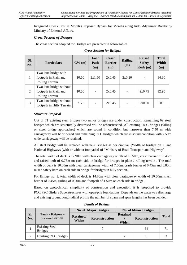
Integrated Check Post at Moreh (Proposed Bypass for Moreh) along Indo -Myanmar Border by Ministry of External Affairs.
Cross Section of Bridges
The cross section adopted for Bridges are presented in below tables
Cross Section for Bridges
Sl. No.
Particulars CW (m) Foot Path (m)
Crash Barrier
(m)
Railing (m)
Raised Safety
Kerb (m)
Total Width
(m)
1 Two lane bridge with footpath in Plain and Rolling Terrain.
10.50 2x1.50 2x0.45 2x0.20 - 14.80
2 Two lane bridge without footpath in Plain and Rolling Terrain.
10.50 - 2x0.45 - 2x0.75 12.90
3 Two lane bridge without footpath in Hilly Terrain
7.50 - 2x0.45 - 2x0.80 10.0
Structure Proposal
Out of 71 existing steel bridges two minor bridges are under construction. Remaining 69 steel bridges which are structurally distressed will be reconstructed. All existing RCC bridges (falling on steel bridge approaches) which are sound in condition but narrower than 7.50 m wide carriageway will be widened and remaining RCC bridges which are in sound condition with 7.50m wide carriageway will be retained.
All steel bridge will be replaced with new Bridges as per circular {Width of bridges on 2 lane National Highways (with or without footpath)} of “Ministry of Road Transport and Highway”.
The total width of deck is 12.90m with clear carriageway width of 10.50m, crash barrier of 0.45m and raised kerb of 0.75m on each side in bridge for bridges in plain / rolling terrain . The total width of deck is 10.00m with clear carriageway width of 7.50m, crash barrier of 0.45m and 0.80m raised safety kerb on each side in bridge for bridges in hilly section.
For Bridge no. 1, total width of deck is 14.80m with clear carriageway width of 10.50m, crash barrier of 0.45m, railing of 0.20m and footpath of 1.50m on each side in bridge.
Based on geotechnical, simplicity of construction and execution, it is proposed to provide
PCC/PSC Girders Superstructures with open/pile foundations. Depends on the waterway discharge
and existing ground longitudinal profile the number of spans and span lengths has been decided.
Details of Bridges
SI. No.
Tamu - Kyigone – Kalewa Section
No. of Major Bridges No. of Minor Bridges
Total Retained/ Widen
Reconstruction Retained
/ Widen
Reconstruction
1 Existing Steel Bridges
7 64 71
2 Existing RCC bridges 2 1 3
KD5 :Final Feasibility Report including Schedules
Consultancy Services for Preparation of Feasibility Report for Construction of Bridges including Approaches on Tamu – Kyigone – Kalewa Road Section from km 0.00 to km 149.70 in Myanmar
MEA 0-8
falling on approaches of steel bridges
Proposed Major Bridges
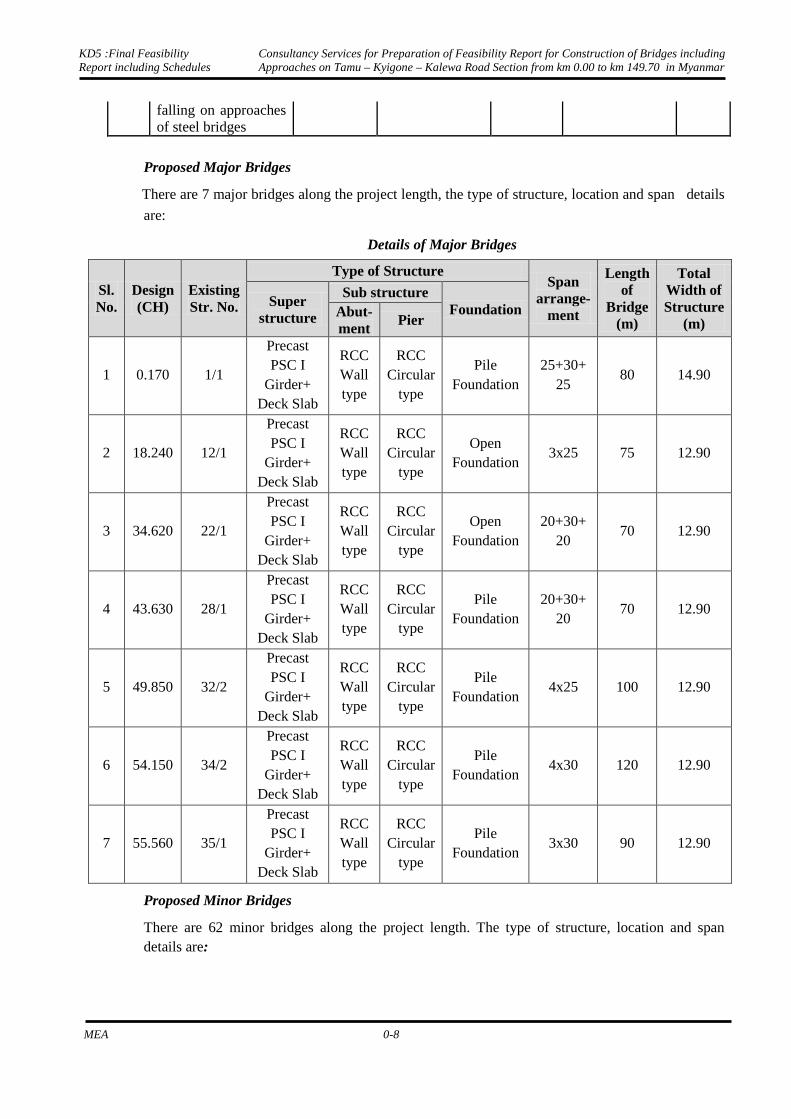
There are 7 major bridges along the project length, the type of structure, location and span details
are:
Details of Major Bridges
Sl. No.
Design (CH)
Existing Str. No.
Type of Structure Span
arrange-ment
Length of
Bridge (m)
Total Width of Structure
(m)
Super structure
Sub structure Foundation Abut-
ment Pier
1 0.170 1/1
Precast PSC I
Girder+ Deck Slab
RCC Wall type
RCC Circular
type
Pile Foundation
25+30+ 25
80 14.90
2 18.240 12/1
Precast PSC I
Girder+ Deck Slab
RCC Wall type
RCC Circular
type
Open Foundation
3x25 75 12.90
3 34.620 22/1
Precast PSC I
Girder+ Deck Slab
RCC Wall type
RCC Circular
type
Open Foundation
20+30+ 20
70 12.90
4 43.630 28/1
Precast PSC I
Girder+ Deck Slab
RCC Wall type
RCC Circular
type
Pile Foundation
20+30+ 20
70 12.90
5 49.850 32/2
Precast PSC I
Girder+ Deck Slab
RCC Wall type
RCC Circular
type
Pile Foundation
4x25 100 12.90
6 54.150 34/2
Precast PSC I
Girder+ Deck Slab
RCC Wall type
RCC Circular
type
Pile Foundation
4x30 120 12.90
7 55.560 35/1
Precast PSC I
Girder+ Deck Slab
RCC Wall type
RCC Circular
type
Pile Foundation
3x30 90 12.90
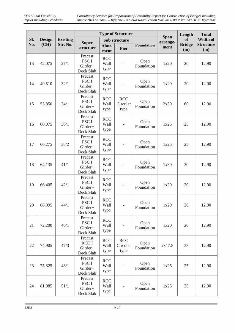
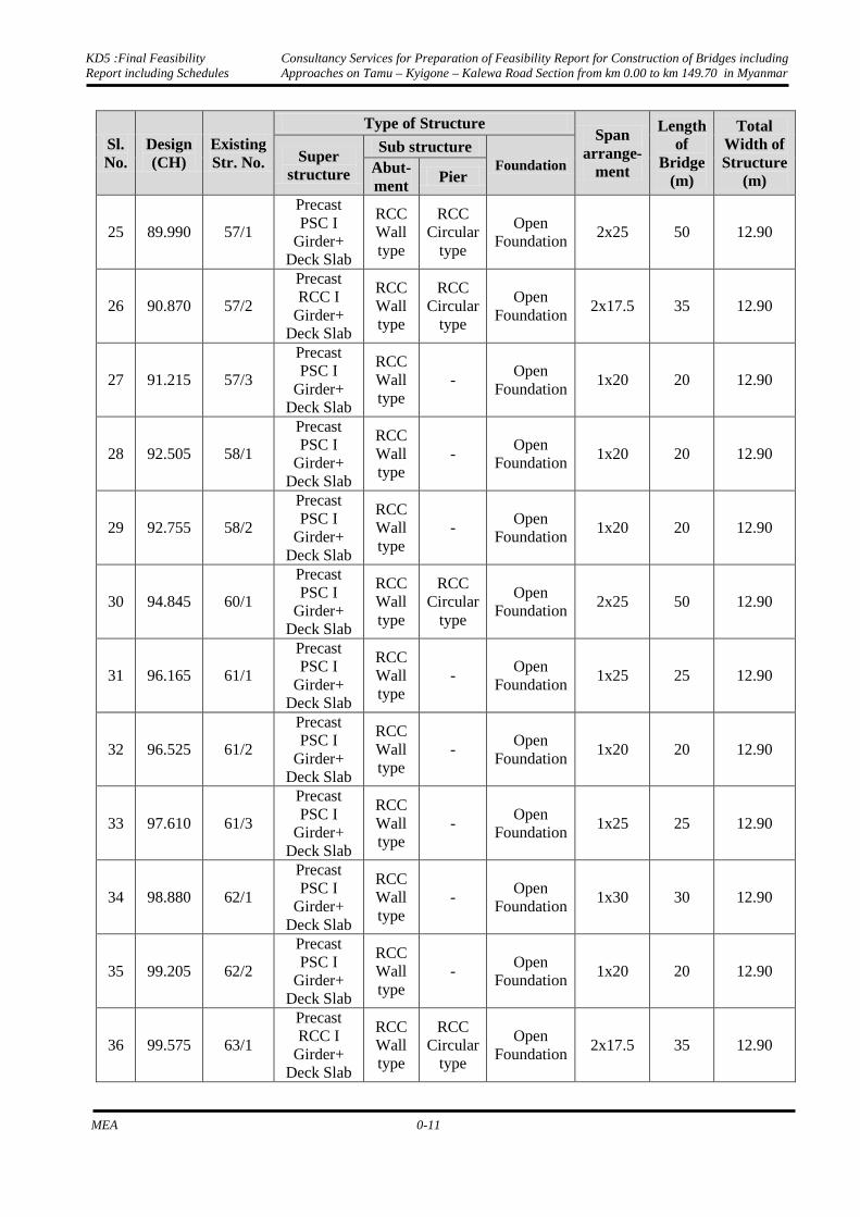
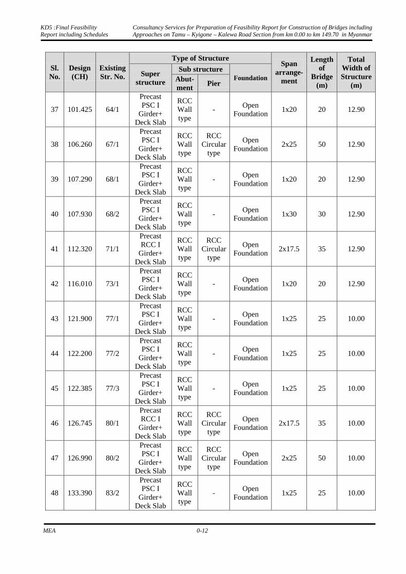
Proposed Minor Bridges
There are 62 minor bridges along the project length. The type of structure, location and span details are:

KD5 :Final Feasibility Report including Schedules
Consultancy Services for Preparation of Feasibility Report for Construction of Bridges including Approaches on Tamu – Kyigone – Kalewa Road Section from km 0.00 to km 149.70 in Myanmar
MEA 0-9
Details of Minor Bridges
Sl. No.
Design (CH)
Existing Str. No.
Type of Structure Span
arrange-ment
Length of
Bridge (m)
Total Width of Structure
(m)
Super structure
Sub structure Foundation Abut-
ment Pier
1 4.880 4/1 Precast PSC
I Girder+ Deck Slab
RCC Wall type
RCC Circular
type
Open Foundation
2x20 40 12.90
2 10.880 7/1
Precast PSC I
Girder+ Deck Slab
RCC Wall type
RCC Circular
type
Pile Foundation
2x30 60 12.90
3 12.000 8/1
Precast PSC I
Girder+ Deck Slab
RCC Wall type
- Open
Foundation 1x20 20 12.90
4 13.740 9/1
Precast PSC I
Girder+ Deck Slab
RCC Wall type
- Open
Foundation 1x30 30 12.90
5 15.760 10/2
Precast PSC I
Girder+ Deck Slab
RCC Wall type
- Open
Foundation 1x20 20 12.90
6 19.575 13/2
Precast PSC I
Girder+ Deck Slab
RCC Wall type
- Open
Foundation 1x20 20 12.90
7 22.470 15/1
Precast PSC I
Girder+ Deck Slab
RCC Wall type
- Open
Foundation 1x30 30 12.90
8 25.130 16/2
Precast PSC I
Girder+ Deck Slab
RCC Wall type
- Open
Foundation 1x20 20 12.90
9 27.290 18/1
Precast PSC I
Girder+ Deck Slab
RCC Wall type
RCC Circular
type
Open Foundation
2x30 60 12.90
10 27.725 18/2
Precast PSC I
Girder+ Deck Slab
RCC Wall type
- Open
Foundation 1x20 20 12.90
11 31.040 20/2
Precast PSC I
Girder+ Deck Slab
RCC Wall type
RCC Circular
type
Open Foundation
2x30 60 12.90
12 36.930 24/1
Precast RCC I
Girder+ Deck Slab
RCC Wall type
RCC Circular
type
Open Foundation
2x17.5 35 12.90
KD5 :Final Feasibility Report including Schedules
Consultancy Services for Preparation of Feasibility Report for Construction of Bridges including Approaches on Tamu – Kyigone – Kalewa Road Section from km 0.00 to km 149.70 in Myanmar
MEA 0-10
Sl. No.
Design (CH)
Existing Str. No.
Type of Structure Span
arrange-ment
Length of
Bridge (m)
Total Width of Structure
(m)
Super structure
Sub structure Foundation Abut-
ment Pier
13 42.075 27/1
Precast PSC I
Girder+ Deck Slab
RCC Wall type
- Open
Foundation 1x20 20 12.90
14 49.510 32/1
Precast PSC I
Girder+ Deck Slab
RCC Wall type
- Open
Foundation 1x20 20 12.90
15 53.850 34/1
Precast PSC I
Girder+ Deck Slab
RCC Wall type
RCC Circular
type
Open Foundation
2x30 60 12.90
16 60.075 38/1
Precast PSC I
Girder+ Deck Slab
RCC Wall type
- Open
Foundation 1x25 25 12.90
17 60.275 38/2
Precast PSC I
Girder+ Deck Slab
RCC Wall type
- Open
Foundation 1x25 25 12.90
18 64.135 41/1
Precast PSC I
Girder+ Deck Slab
RCC Wall type
- Open
Foundation 1x30 30 12.90
19 66.405 42/1
Precast PSC I
Girder+ Deck Slab
RCC Wall type
- Open
Foundation 1x20 20 12.90
20 68.995 44/1
Precast PSC I
Girder+ Deck Slab
RCC Wall type
- Open
Foundation 1x20 20 12.90
21 72.200 46/1
Precast PSC I
Girder+ Deck Slab
RCC Wall type
- Open
Foundation 1x20 20 12.90
22 74.905 47/3
Precast RCC I
Girder+ Deck Slab
RCC Wall type
RCC Circular
type
Open Foundation
2x17.5 35 12.90
23 75.325 48/1
Precast PSC I
Girder+ Deck Slab
RCC Wall type
- Open
Foundation 1x25 25 12.90
24 81.085 51/1
Precast PSC I
Girder+ Deck Slab
RCC Wall type
- Open
Foundation 1x25 25 12.90
KD5 :Final Feasibility Report including Schedules
Consultancy Services for Preparation of Feasibility Report for Construction of Bridges including Approaches on Tamu – Kyigone – Kalewa Road Section from km 0.00 to km 149.70 in Myanmar
MEA 0-11
Sl. No.
Design (CH)
Existing Str. No.
Type of Structure Span
arrange-ment
Length of
Bridge (m)
Total Width of Structure
(m)
Super structure
Sub structure Foundation Abut-
ment Pier
25 89.990 57/1
Precast PSC I
Girder+ Deck Slab
RCC Wall type
RCC Circular
type
Open Foundation
2x25 50 12.90
26 90.870 57/2
Precast RCC I
Girder+ Deck Slab
RCC Wall type
RCC Circular
type
Open Foundation
2x17.5 35 12.90
27 91.215 57/3
Precast PSC I
Girder+ Deck Slab
RCC Wall type
- Open
Foundation 1x20 20 12.90
28 92.505 58/1
Precast PSC I
Girder+ Deck Slab
RCC Wall type
- Open
Foundation 1x20 20 12.90
29 92.755 58/2
Precast PSC I
Girder+ Deck Slab
RCC Wall type
- Open
Foundation 1x20 20 12.90
30 94.845 60/1
Precast PSC I
Girder+ Deck Slab
RCC Wall type
RCC Circular
type
Open Foundation
2x25 50 12.90
31 96.165 61/1
Precast PSC I
Girder+ Deck Slab
RCC Wall type
- Open
Foundation 1x25 25 12.90
32 96.525 61/2
Precast PSC I
Girder+ Deck Slab
RCC Wall type
- Open
Foundation 1x20 20 12.90
33 97.610 61/3
Precast PSC I
Girder+ Deck Slab
RCC Wall type
- Open
Foundation 1x25 25 12.90
34 98.880 62/1
Precast PSC I
Girder+ Deck Slab
RCC Wall type
- Open
Foundation 1x30 30 12.90
35 99.205 62/2
Precast PSC I
Girder+ Deck Slab
RCC Wall type
- Open
Foundation 1x20 20 12.90
36 99.575 63/1
Precast RCC I
Girder+ Deck Slab
RCC Wall type
RCC Circular
type
Open Foundation
2x17.5 35 12.90
KD5 :Final Feasibility Report including Schedules
Consultancy Services for Preparation of Feasibility Report for Construction of Bridges including Approaches on Tamu – Kyigone – Kalewa Road Section from km 0.00 to km 149.70 in Myanmar
MEA 0-12
Sl. No.
Design (CH)
Existing Str. No.
Type of Structure Span
arrange-ment
Length of
Bridge (m)
Total Width of Structure
(m)
Super structure
Sub structure Foundation Abut-
ment Pier
37 101.425 64/1
Precast PSC I
Girder+ Deck Slab
RCC Wall type
- Open
Foundation 1x20 20 12.90
38 106.260 67/1
Precast PSC I
Girder+ Deck Slab
RCC Wall type
RCC Circular
type
Open Foundation
2x25 50 12.90
39 107.290 68/1
Precast PSC I
Girder+ Deck Slab
RCC Wall type
- Open
Foundation 1x20 20 12.90
40 107.930 68/2
Precast PSC I
Girder+ Deck Slab
RCC Wall type
- Open
Foundation 1x30 30 12.90
41 112.320 71/1
Precast RCC I
Girder+ Deck Slab
RCC Wall type
RCC Circular
type
Open Foundation
2x17.5 35 12.90
42 116.010 73/1
Precast PSC I
Girder+ Deck Slab
RCC Wall type
- Open
Foundation 1x20 20 12.90
43 121.900 77/1
Precast PSC I
Girder+ Deck Slab
RCC Wall type
- Open
Foundation 1x25 25 10.00
44 122.200 77/2
Precast PSC I
Girder+ Deck Slab
RCC Wall type
- Open
Foundation 1x25 25 10.00
45 122.385 77/3
Precast PSC I
Girder+ Deck Slab
RCC Wall type
- Open
Foundation 1x25 25 10.00
46 126.745 80/1
Precast RCC I
Girder+ Deck Slab
RCC Wall type
RCC Circular
type
Open Foundation
2x17.5 35 10.00
47 126.990 80/2
Precast PSC I
Girder+ Deck Slab
RCC Wall type
RCC Circular
type
Open Foundation
2x25 50 10.00
48 133.390 83/2
Precast PSC I
Girder+ Deck Slab
RCC Wall type
- Open
Foundation 1x25 25 10.00

KD5 :Final Feasibility Report including Schedules
Consultancy Services for Preparation of Feasibility Report for Construction of Bridges including Approaches on Tamu – Kyigone – Kalewa Road Section from km 0.00 to km 149.70 in Myanmar
MEA 0-13
Sl. No.
Design (CH)
Existing Str. No.
Type of Structure Span
arrange-ment
Length of
Bridge (m)
Total Width of Structure
(m)
Super structure
Sub structure Foundation Abut-
ment Pier
49 133.610 84/1
Precast PSC I
Girder+ Deck Slab
RCC Wall type
- Open
Foundation 1x25 25 10.00
50 134.460 85/1
Precast PSC I
Girder+ Deck Slab
RCC Wall type
- Open
Foundation 1x25 25 10.00
51 136.460 86/1
Precast PSC I
Girder+ Deck Slab
RCC Wall type
- Open
Foundation 1x25 25 10.00
52 138.110 86/2
Precast PSC I
Girder+ Deck Slab
RCC Wall type
- Open
Foundation 1x20 20 10.00
53 138.525 87/1
Precast PSC I
Girder+ Deck Slab
RCC Wall type
- Open
Foundation 1x20 20 10.00
54 139.380 87/2
Precast PSC I
Girder+ Deck Slab
RCC Wall type
- Open
Foundation 1x20 20 10.00
55 140.240 88/1
Precast PSC I
Girder+ Deck Slab
RCC Wall type
- Open
Foundation 1x25 25 10.00
56 141.390 88/2
Precast PSC I
Girder+ Deck Slab
RCC Wall type
- Open
Foundation 1x25 25 10.00
57 142.820 89/1
Precast PSC I
Girder+ Deck Slab
RCC Wall type
- Open
Foundation 1x20 20 10.00
58 145.320 90/1
Precast PSC I
Girder+ Deck Slab
RCC Wall type
RCC Circular
type
Open Foundation
1x25 25 10.00
59 146.340 91/1
Precast PSC I
Girder+ Deck Slab
RCC Wall type
RCC Circular
type
Open Foundation
1x20 20 10.00
60 146.590 91/3
Precast PSC I
Girder+ Deck Slab
RCC Wall type
RCC Circular
type
Open Foundation
1x20 20 10.00

KD5 :Final Feasibility Report including Schedules
Consultancy Services for Preparation of Feasibility Report for Construction of Bridges including Approaches on Tamu – Kyigone – Kalewa Road Section from km 0.00 to km 149.70 in Myanmar
MEA 0-14
Sl. No.
Design (CH)
Existing Str. No.
Type of Structure Span
arrange-ment
Length of
Bridge (m)
Total Width of Structure
(m)
Super structure
Sub structure Foundation Abut-
ment Pier
61 147.490 92/1
Precast PSC I
Girder+ Deck Slab
RCC Wall type
RCC Circular
type
Open Foundation
1x25 25 10.00
62 147.940 92/2
Precast PSC I
Girder+ Deck Slab
RCC Wall type
RCC Circular
type
Open Foundation
1x25 25 10.00
Details of Minor Bridges in Approaches
The existing RCC Bridge at Ch.107.341 falling in the approach is proposed for reconstruction. The type of structure, location and span details are:
Details of Minor Bridges for Reconstruction
Sl. No.
Design (CH)
Existing Str. No.
Type of Structure Span
arrangement
Length of
Bridge (m)
Total Width of Structure
(m)
Super structure
Sub structure Foundati
on Abut-ment Pier
1 107.341 68/1 RCC I
Girder + Deck Slab
RCC Wall type
- Open
Foundation
1x12.0 12 12.90
Existing RCC bridges at Ch. 107.711 and Ch. 133.502 are proposed to retain. The type of structure,
location and span details are:
Details of Retained Minor Bridges
Sl. No.
Design (Chainage)
Existing Str. No.
Type of Structure Span arrange
ment
Length of
Bridge (m)
Total Width of Structure
(m)
Super structure
Sub structure Foundation
Abutment Pier
1 107.711 68/2 Slab RCC Wall
type -
Open Foundation
1x7.40 7.4 8.10
2 133.502 83/4 RCC Slab RCC Wall
type -
Open Foundation
1x6.30 6.6 12.00
Detail of Bridges under Construction
The following two minor bridges are under construction and the details are
Detail of Under Construction Bridges
Sl. No. Design (Chainage) Existing Structure No. Remarks 1 143.270 89/2 Under Construction 2 131.520 82/1 Under Construction
Culverts

KD5 :Final Feasibility Report including Schedules
Consultancy Services for Preparation of Feasibility Report for Construction of Bridges including Approaches on Tamu – Kyigone – Kalewa Road Section from km 0.00 to km 149.70 in Myanmar
MEA 0-15
There are total 59 numbers of culverts consisting of 44 Slab, 6 Arch and 9 Hume Pipe culverts. The condition of most of these CD structures are fair to good.
Geometric Design
Geometric design involves the design of the visible elements such as horizontal alignment, vertical alignment and the cross-section of the project road. The design is governed by the design speed fixed up taking into account site conditions including the terrain in which the project road traverses.
The project road traverses through plain/rolling and hilly terrain and a design speed of 100/80 kmph & 50/40kmph has been provided. However the minimum values have been applied only where serious restrictions are placed by technical or economic considerations. At few locations design speed has been reduced due to unavoidable circumstances. General effort has been made to exceed the design speed on safer side.
The entire geometric design has been based on the ground modelling by highway design software MOSS/MX Road.
Pavement Design
Based on the traffic projections and the Vehicle Damage Factor (VDF) of various types of commercial vehicles, Cumulative standard Axles (CSA) during the period of design life have been computed for the homogeneous sections.
Vehicle Damage Factor for Project Road
Mode Km 12.5 Km 122.5
LGV 0.45 0.49 2 axle Truck 3.24 3.27 3 Axle Truck 3.81 3.84 MAV 2.59 2.95
The pavement composition as evaluated from IRC: 37, 2012 for the different sections of the
project road are summarized in below Table
Pavement Composition for New Construction
Homogeneous Sections (KM)
CBR (%)
Design Traffic (msa)
Pavement Composition (mm)
BC DBM WMM GSB Sub-grade
Km 0.000 to km 121.690 7% 20 40 90 250 230 500
Km 121.690 to km 149.700 7% 20 40 90 250 230 500
*BC: Bituminous Concrete, WMM: Wet Mix Macadam; GSB: Granular Sub base.
0.4 ENVIRONMENT AND SOCIAL IMPACT ASSESSMENT
Significant Findings
The E & SIA report was prepared after thorough interaction with the engineering section of the consultants so that the negative impacts on the environment and human population could be avoided as far as possible. Some of the important findings of the study are as follows: -

KD5 :Final Feasibility Report including Schedules
Consultancy Services for Preparation of Feasibility Report for Construction of Bridges including Approaches on Tamu – Kyigone – Kalewa Road Section from km 0.00 to km 149.70 in Myanmar
MEA 0-16
1. There will be no loss of bio-diversity as no rare plant or animal species are going to be affected by the present project.
2. No Sanctuary or National Park is located within 10 km radius of the bridges.
3. No historical monuments are located near the bridges.
4. The most important factors, which need continuous attention and assessment during the construction phase, are the ambient air quality, the water quality and the noise level. The ambient air quality of the study area is good. The quality of the ground water is good for drinking as well as other daily use purpose. Noise levels in the area, particularly at crossing points and in the urban settlement, exceed the limits.
5. The proposed alignment of the bridges and their approaches would be such that it has minimum impact on physical and social environment. Approximately 158 numbers of trees may be cut down due to the proposed approach roads connecting bridges. No forest area will be diverted.
0.5 RATE ANALYSIS PROJECT COST ESTIMATE AND IMPLEMENTATION
SCHEDULE
The quantities of major items of work for the Project road have been estimated on the basis of Pavement design, geometric design and structural design.
The quantities of the following major items of works has been estimated separately.
• Site Clearance
• Earth Works
• Granular Sub-base and Base Courses
• Bituminous Courses
• Bridges, Culverts and Retaining Walls etc.
• Kerbs, Drainage and Protective Works
• Road Furniture and Safety Works
• Traffic Management and Miscellaneous.
The cost estimate for works item is presented in below Table
Project Cost Estimate
Bill No. Description of Item Amount
1 Site Clearance 33704059 2 Earth Work 99741706 3 Sub-Base And Base Courses 338453038 4 Bituminous Works 249567085 5 Culverts 36677715 6 Road Markings & Sign Boards 26893765 7 Drainage And Protection Works 345384839 8 Bridges 1530507777 9 Miscellaneous 141124915 Sub Total 2802054898

KD5 :Final Feasibility Report including Schedules
Consultancy Services for Preparation of Feasibility Report for Construction of Bridges including Approaches on Tamu – Kyigone – Kalewa Road Section from km 0.00 to km 149.70 in Myanmar
MEA 0-17

Chapter 1
Introduction

KD5 :Final Feasibility Report including Schedules
Consultancy Services for Preparation of Feasibility Report for Construction of Bridges including Approaches on Tamu – Kyigone – Kalewa Road Section from km 0.00 to km 149.70 in Myanmar
MEA 1-1
1. INTRODUCTION
1.1 BACKGROUND
The President of India acting through the Ministry of External Affairs (MEA), Government of India, seeks the services of qualified firms for preparing a Feasibility Report for construction of seventy one 2- lane Bridges including approaches in replacement of old steel bridges (single lane) on Tamu – Kyigone - Kalewa road section from km 0.00 to 149.70 in Myanmar on Engineering, Procurement and Construction (EPC) basis.
1.2 OBJECTIVE
The main objective of the Consultancy service is to undertake feasibility study and prepare feasibility report including preliminary designs and cost estimate for the construction of bridges including approaches with a view to ensuring;
(i) Enhanced safety and level of service for the road users;
(ii) Superior operation and maintenance enabling enhanced operational efficiency of the existing road;
(iii) Minimal adverse impact on the local population and road users due to construction/ reconstruction of bridges and approaches;
(iv) Minimal adverse impact on environment;
(v) Minimal land acquisition; and
(vi) Sound technical and cost effective design.
Tamu – Kyigone - Kalewa road is intermediate lane width and passes through plain & hilly terrain. The project road starts at India-Myanmar Border at Tamu in Myanmar and end at Kalewa at km 149.7 in Myanmar. The project road section is shown in the index map at Fig. 1.1.

KD5 :Final Feasibility Report including Schedules
Consultancy Services for Preparation of Feasibility Report for Construction of Bridges including Approaches on Tamu – Kyigone – Kalewa Road Section from km 0.00 to km 149.70 in Myanmar
MEA 1-2
Fig. 1.1: Index Map

Chapter 2
Project Description

KD5 :Final Feasibility Report including Schedules
Consultancy Services for Preparation of Feasibility Report for Construction of Bridges including Approaches on Tamu – Kyigone – Kalewa Road Section from km 0.00 to km 149.70 in Myanmar
MEA 2-1
2. PROJECT DESCRIPTION
2.1 INTRODUCTION
This chapter deals with brief description of the project highlighting the salient features of the project road and the concept of construction of Bridges including approaches has been discussed.
2.2 PROJECT DESCRIPTION
Tamu - Kyigone - Kalewa road is of intermediate lane width and passes through plain and hilly terrain. The road is generally in good condition except the bridges which are old steel bridges of single lane width and are proposed to be replaced by two lane wide bridges for Class 70 R loading
The project road starts at km 0.00 (93.0 milestone) at India Myanmar border near Tamu (Bridge no. 1) and ends at km 149.70 (0.0 milestone) at Kalewa.
Photographs of First Bridge (Start Point) and last bridge (End Point) of the Project Road are given belowinPhoto 2.1 to 2.2.
Photo 2.1: First Bridge (Start Point) (Indian-Myanmar border)
Photo 2.2: Last Bridge (End Point)
The land use by the side of the Project road includes agriculture activities, residential use, commercial and open areas. The project road passes through following important Towns/Villages as list below:
Sr. no. Location (in Km)
Name of Settlement/Villages
1 0.0 Tamu Town
2 13.5 Pan Tha Village
3 20.2 Nan Mon Tar Village
4 27.7 Witoke Village
5 38.6 Boken Village
6 56.3 Khampat Town
7 108.8 Sakhangyi Village
8 121.7 Kyi Gone Village
9 150.0 Kalewa Town

KD5 :Final Feasibility Report including Schedules
Consultancy Services for Preparation of Feasibility Report for Construction of Bridges including Approaches on Tamu – Kyigone – Kalewa Road Section from km 0.00 to km 149.70 in Myanmar
MEA 2-2
2.3 STUDY OF EXISTING ALIGNMENT
The project road starts at Indian/Myanmar border at Tamu in Myanmar and ends nearKalewa i.e. at Km 149.7. The first bridge of the Project section is the international border between India and Myanmar. This bridge connects Moreh in the state of Manipur of India and Tamu in Myanmar.
The alignment from Km 0.000 to Km 121.690 i.e. between Tamu and Kyigone is passing through Plain and Rolling terrain. From Kyigone to Kalewa the project road is passing through hilly terrain. The land use observed along the alignment section is predominantly agriculture and open lands and some sections are passing through settlement areas along the road. Some of the sections where the alignment passes through built-up area areshown in Photo 2.3 to 2.6.
Photo 2.3: Pantha Village at
km 13.500
Photo 2.4:Nan Mon Tar Village at
km 20.00
Photo 2.5:Khampat Town at
km56.30
Photo 2.6:Sakhangyi Village at
km 108.80
2.3.1 Existing Carriageway
The existing carriageway width of the project road is 5.50m with earthen shoulder varying from 0.5m to 2.20m on both sides. Based on the visual observation, the condition of the existing pavement is categorised as fair to good and shoulders at many locations are in poor condition.
2.3.2 Existing Horizontal and Vertical Profile
At many locations it was observed that horizontal alignment has S curves, broken back curves and small radius not conforming the IRC Standards. At many locations vertical curves do not conform to IRC Standards.Photos 2.7 to 2.10 depict the alignment geometry.

KD5 :Final Feasibility Report including Schedules
Consultancy Services for Preparation of Feasibility Report for Construction of Bridges including Approaches on Tamu – Kyigone – Kalewa Road Section from km 0.00 to km 149.70 in Myanmar
MEA 2-3
Photo 2.7: T Junction at Start Point Photo 2.8:Sharp curve at Bridge-7 at
km 18.240
Photo 2.9: Sharp curve at Bridge-51 at
km 122.200
Photo 2.10:Sharp curve at Bridge -56 at
km 133.400
2.3.3 Right of Way
The existing Right of Way varies from 30m to 70m all along the project road.
2.3.4 Current Development Activities
The existing road is being maintained in various stretches between km 124.00 to 147.00 by thePWD. Photo 2.11 &2.12depict the maintenance work under progress on these stretches.
Photo 2.11: Maintenance work under progress near km 139.0
Photo 2.12: Maintenance work under progress near km 147.0

KD5 :Final Feasibility Report including Schedules
Consultancy Services for Preparation of Feasibility Report for Construction of Bridges including Approaches on Tamu – Kyigone – Kalewa Road Section from km 0.00 to km 149.70 in Myanmar
MEA 2-4
Bridge no. 55 (82/1) at km 131.520 and Bridge no. 66 (89/2) at km 143.270 are under construction. Photo 2.13 &2.14depict the construction work under progress at Bridges no 55 and Photo 2.15 &2.16depict the construction work under progress at Bridge no. 66.
Photo 2.13: Construction work under progress at Km 131.520 (Bridge No. 55)
Photo 2.14: Construction work under progress at Km 131.520 (Bridge No. 55)
Photo 2.15: Construction work under progress at Km 143.270 (Bridge No. 66)
Photo 2.16: Construction work under progress at Km 143.270 (Bridge No. 66)
2.3.5 Details of Bridges and Culverts
There are total 71 steel bridges on the project road. Out of 71 steel bridges, two minor bridges are under construction. Remaining 69 steel bridges which are structurally distressed required to be reconstructed.
In addition to the steel bridges, there are existing RCC bridges on the project road. 3 no. of RCC bridges which are falling on the approaches of the steel bridges are considered for the study.
There are total 59 numbers of culverts consisting of 44 Slab, 6 Arch and 9 Hume Pipe culverts falling on the approaches of the steel bridges, and are considered for the study.
Details of all structures are provided in Chapter 4
Chapter 3
Socio Economic Profile

KD5 :Final Feasibility Report including Schedules
Consultancy Services for Preparation of Feasibility Report for Construction of Bridges including Approaches on Tamu – Kyigone – Kalewa Road Section from km 0.00 to km 149.70 in Myanmar
MEA 3-1
3. SOCIO ECONOMIC PROFILE
3.1 GENERAL
Myanmar is situated in Southeast Asia and is bordered on the north and northeast by China; on the
east and Southeast by Laos and Thailand; on the south by the Andaman Sea and the Bay of Bengal;
and on the west by Bangladesh and India. It is located between latitudes 09°32’N and 28°31’N and
longitudes 92°10’E and 101°11’E. The country covers an area of 677,000 square kilometers
(261,228 square miles) ranging 936 kilometers (581 miles) from east to west and 2,051 kilometers
(1,275 miles) from north to south.
The project road Tamu – Kyigone - Kalewa is intermediate lane width and passes through plain &
hilly terrain. The project road starts at India-Myanmar Border at Tamu in Myanmar and end at
Kalewa at km 149.7 in Myanmar
Figure 3.1: Location of Sagaing division in Myanmar
3.2 PROJECT ROAD
The project road (India Myanmar Friendship Road) runs, in the North - South direction in the
Sagaing division of Myanmar. The project road takes off from km 0.000, India/Myanmar Border
nearTamu and ends at km 149.700 in Kalewa. There are around 46 villages/towns situated along the
project road as listed below in Table 3.1.
Table3.1:List of Settlement/Villages along the Project Road
Sr. no. Location (in Km)
Name of Settlement/Villages
1 0.0 Tamu Town 2 9.6 Htan Ta Pin Village 3 10.5 Man Maw Village 4 13.5 Pan Tha Village 5 20.2 Nan Mon Tar Village 6 18.6 KhonMonn Non Village 7 20.2 Yen Alin Fin

KD5 :Final Feasibility Report including Schedules
Consultancy Services for Preparation of Feasibility Report for Construction of Bridges including Approaches on Tamu – Kyigone – Kalewa Road Section from km 0.00 to km 149.70 in Myanmar
MEA 3-2
Sr. no. Location (in Km)
Name of Settlement/Villages
8 27.7 Witoke Village 9 31.4 Tit TitYan 10 33.6 YantinAung 11 36.2 Tywan Village 12 38.6 Boken Village 13 46.3 TheinZin 14 52.3 Ka ma Kyee Village 15 53.4 Kanan Village 16 56.3 Khampat Town 17 63.2 Nan katate Village 18 66.8 Nan KhotKhotVilage 19 74.8 KyunnDaw Yay Shin Village 20 72.9 Phatyaryashin 21 76.0 Saw Bwa Yay Shin 22 81.6 YanmyoAung 23 86.9 Kaontha 24 89.4 Khontar 25 95.6 Kanhla 26 99.8 Kanoo 27 101.1 SonelarMying 28 103.1 KanTharYar 29 107.9 Nann Han Nwe 30 108.8 Sakhangyi 31 113.3 Nanbaho 32 115.9 Maw Like Kalay 33 117.0 In DaingKalay 34 118.5 In DaingGyi 35 121.7 Kyi Gone 36 128.1 ItayaSite Khin 37 130.4 Nat Kyi Gone 38 132.0 Yanan Chang 39 134.6 KyaukKar 40 136.2 KbayaeMyaing 41 139.6 Chaung Chin 42 140.8 Doe Pin Chaut 43 142.5 ThitChaut 44 144.2 NwarSwe 45 146.0 Nat Tet 46 150.0 Kalewa Town
3.3 GEOLOGY
The geological map of Myanmar shows thatin the region of project road, most of the area under soft
rock predominantly under the category of bedrock. The area around the last 15 km of alignment
passing from hard and soft rock of Sandstone, limestone, shale and conglomerate.
3.4 RIVERS / STREAMS /WATER COURSES
The Chindwin river basin is located in North-western part of Myanmar in Sagaing region.The
KD5 :Final Feasibility Report including Schedules
Consultancy Services for Preparation of Feasibility Report for Construction of Bridges including Approaches on Tamu – Kyigone – Kalewa Road Section from km 0.00 to km 149.70 in Myanmar
MEA 3-3
project road is in the vicinity of Chindwin River. As a result a number of water courses/ streams
have been formed across the proposed alignment. The major streams crossing the project road
areLakchao, Nanpalong, Lalim, Nie-Ell-Kiaiz, Tuivang, Kanmagyi, Kannan and some local
streams.
3.5 CLIMATE
Myanmar has three main seasons, hot season, rainy season and cold season. Hot season is from
March to May, rainy season is from June to October and cold season is from November to
February. The tropical monsoon is usually cloudy, rainy, hot, humid summers and less cloudy,
scant rainfall, mild temperatures, lower humidity during winter.
April and May are the hottest months in the project area, while the extreme temperature varies but
mean maximum temperature works out to be 31º C in Mawlik Town. During the rainy season, from
May to September, climateremains very humid. During winter season and particularly rainy season,
thick, low lying clouds reduce visibility, impede movement and hold up work. Depending on the
variation in temperatures and general weather conditions, three different types of seasons are
observed in Project Influence Area (PIA):
Winter: Starts from November and lasts till February. The temperature is comparatively lower
(11° C – 28° C), but not too low to make human habitation difficult. The season
receives very little rainfall.
Spring: Season begins from March and lasts till first half of May and merges with rainy
season. The temperature rises up to a range of 16° C to 35° C being aggravated by
rainless days.
Rain: This is the longest season; hold out for nearly sixmonths from second mid of May till
late October. Rainfall is very heavy from June toSeptember, and maximum rainfall
observed in the month of September.
Elevation and distance from the sea affect temperature as well. Although Myanmargenerally is a
tropical country, temperatures are not uniformly high throughout the year. The daily temperature
range is greater than that in nearly all other parts of Southeast Asia, but no locality has a continental
type of climate (i.e., one characterized by large seasonal differences in average temperature).
Mandalay, in the centre of the dry zone, has some of the greatest daily temperature ranges, which
span about 12 °C annually. In broader perspective, however, average daily temperatures show little
variation, ranging from 26 °C to 28 °C between Sittwe (Akyab) in the Rakhine region, Yangon near
the coast, and Mandalay in the northern part of the central basin. At Lashio, on the Shan Plateau,
the average daily temperature is somewhat cooler, around 22 °C.
3.6 SOCIO ECONOMIC PROFILE
Area and Population
The total area of Myanmar is 678,500 sq km where 657,740 sq km occupies the land and 20,760 sq
km occupies the water. The bordering countries are Bangladesh 193 km, China 2,185 km, India
1,463 km, Laos 235 km, and Thailand 1,800 km. The central lowlands ringed by steep, rugged
highlands The lowest point is the Andaman Sea (0 m) and the highest point Hkakabo Razi (5,881
m).

KD5 :Final Feasibility Report including Schedules
Consultancy Services for Preparation of Feasibility Report for Construction of Bridges including Approaches on Tamu – Kyigone – Kalewa Road Section from km 0.00 to km 149.70 in Myanmar
MEA 3-4
Myanmar is made up of 135 national races, of which the main national races are Kachin, Kayah,
Kayin, Chin, Bamar, Mon, Rakhine and Shan. Population is estimated to be over 60
million.Population growth rate shown in Table3.2.Statewise population for the last three years has
shown in Table 3.3.The nationality is Myanmar. There are more than 100 ethnic groups in
Myanmar. Some of the Ethnic groups are listed as Akha, Palaung, Padaung, Naga, Taron, Eng and
many more near extinct tribes. The religions are Buddhist, Christian and Muslim. The major
language is Myanmar, but minority ethnic groups have their own languages. English is widely
spoken and understood.
The majority of Myanmar’s population is rural, with the density of settlement in each region related
to agricultural production, particularly of rice. Thus, the most populous regions are the Irrawaddy
delta and the dry zone, and the highest densities are found in the upper delta, between Yangon and
Hinthada (Henzada). Settlement in the Sittang delta, the sedimented hinterland of Sittwe, and the
regions of both sides of the lower ChindwinRiver is moderately dense. The Rakhine region (except
the Sittwe area), the west bank of the Irrawaddy at the base of the Rakhine Mountains, Tenasserim,
and the less accessible parts of the western and northern mountains and the Shan Plateau are
sparsely inhabited. Although city populations have been growing, the pace of urbanization has not
been as rapid in Myanmar as it has been in most other countries of Southeast Asia.
The population of Myanmar remains fairly youthful, with roughly one-fourth of the people under
age 15. However, the proportion of young people has been decreasing steadily since the late 20th
century, as the birth rate has dropped from notablyabove to significantly below the world average.
Life expectancy, on the contrary, has been on the rise, with most men and women living into their
60s.
Table 3.2: Population Growth Rate
Year Million Annual Growth Rate (%) Male Female Total
2006-2007 28.10 28.42 56.52 2.02 2007-2008 28.58 28.92 57.50 1.75 2008-2009 29.03 29.35 58.38 1.52 2009-2010 29.40 29.73 59.13 1.29 2010-2011 29.72 30.06 59.78 1.10 2011-2012 29.84 30.54 60.38 1.01 2012-2013(Provisional)
30.14 30.84 60.98 0.98
Table 3.3: State-wise population for the last three years
Sr.No Regions/States 2010-11 2011-12 2012-13
In Million In Million In Million 1 Kachin 1.579 1.598 1.616 2 Kayah 0.356 0.36 0.365 3 Kayin 1.816 1.836 1.855 4 Chin 0.554 0.563 0.571 5 Sagaing 6.541 6.598 6.654
6 Tanintharyi 1.714 1.734 1.755

KD5 :Final Feasibility Report including Schedules
Consultancy Services for Preparation of Feasibility Report for Construction of Bridges including Approaches on Tamu – Kyigone – Kalewa Road Section from km 0.00 to km 149.70 in Myanmar
MEA 3-5
Sr.No Regions/States 2010-11 2011-12 2012-13
In Million In Million In Million 7 Bago 6.008 6.067 6.125 8 Magway 5.623 5.677 5.73 9 Mandalay 7.394 7.353 7.423 10 Mon 3.137 3.165 3.193 11 Rakhine 3.306 3.339 3.37 12 Yangon 7.023 7.097 7.17 13 Shan 5.66 5.72 5.78
14 Ayeyarwaddy 8.041 8.124 8.205
15 Naypyitaw 1.028 1.153 1.164
Union Total 59.78 60.384 60.976
Economy
Myanmar’s economy, based on the kyat (the national currency), is one of the least developed of the
region and is basically agricultural. Much of the population is engaged directly in agricultural
pursuits. Of those who are employed in other sectors of the economy, many are indirectly involved
in agriculture through such activities as transporting, processing, marketing, and exporting
agricultural goods.
Nearly half of Myanmar’s economic output—notably all large industrial enterprises, the banking
system, insurance, foreign trade, domestic wholesale trade, and nearly all the retail trade—was
nationalized in 1962–63. Agriculture and fishing were left in the private sector. In 1975–76,
however, the government reorganized nationalized corporations on a more commercial basis and
instituted a bonus system for workers. The overall economic objectives of self-sufficiency and the
exclusion of foreign investment also were revised. Foreign investment was permitted to resume in
1973, although only with the government. Following a military coup in 1988, both foreign and
indigenous private enterprise was encouraged.
Myanmar also has an extensive informal economy. Considerable quantities of consumer goods are
smuggled into the country, and teak and gems are exported both legally and illegally. In addition,
northern Myanmar is one of the largest producers of opium in the world.
Myanmar had undergone various economic systems in her long historical past. Beginning with the
British colonial era, the free market system with the laissez-faire and free trade doctrine had been
the guiding philosophy and policy of the British colonial administration for a century. The national
governments since independence in 1948 till early 1962,practised a mixed-economy model,
allowing the market forces to play a leading role in the development process. Then for 26 years,
since 1962, socialism with a centrally planned economy was adopted. Finally, following the
political disturbances in August 1988, the State Peace and Development Council (SPDC) assumed
power in September 1988, abolishing socialist system and instituting instead market-oriented
economic system. Since November 1988, the SPDC undertook a number of economic stabilization
and reform measures toredress the worsening economic situation of the country. Accordingly, the

KD5 :Final Feasibility Report including Schedules
Consultancy Services for Preparation of Feasibility Report for Construction of Bridges including Approaches on Tamu – Kyigone – Kalewa Road Section from km 0.00 to km 149.70 in Myanmar
MEA 3-6
economy began to recover slightly during 1989-90 to 1991-92, after registering negative growth
rates during the past three consecutive years. Accordingly the economy have achieved high growth
in GDP with annual average growth rate of 7.5% during the first four year plan, 1992-93 to 1995-96
and during the second five year plan, 1996-97 to 2000-2001, an annual average growth rate of 8.5%
was achieved. The GDP growth rate of 2001-2002, the first year of the current five year plan
revealed 11.8%. The GDP Growth rate for year 2011-2012 was 6.30%. GDP growth rate for
various years are shown in Table 3.4.
Table 3.4: GDP growth rate for various years
Year
GDP, bln. Dollars Growth rate of GDP, % Current
prices
Constant prices 1970
2001 7.60 10.20 12.10
2002 10.40 11.40 11.80
2003 9.90 13.00 14.00
2004 10.30 14.70 13.10
2005 11.90 16.70 13.60
2006 13.90 18.90 13.20
2007 18.20 21.20 12.20
2008 25.90 23.30 9.90
2009 32.90 25.80 10.70
2010 41.50 28.40 10.10
2011 55.40 30.10 6.00
2012 59.40 32.00 6.30
Agriculture, forestry, and fishing
Agriculture, forestry, and fishing together constitute the largest contributor to Myanmar’s economy.
About half of all agricultural land in Myanmar is devoted to rice, and to increase production the
government has promoted multiple cropping (sequential cultivation of two or more crops on a
single piece of land in a single year), a system that is easily supported by the country’s climate. As
a whole, the sector accounts for nearly one-half of the country’s gross domestic product (GDP) and
employs about two-thirds of the labour force.
Myanmar may be divided into three agricultural regions: the delta, where cultivation of rice in
flooded paddies predominates; the largely irrigated dry zone, an area primarily of rice production
but where a wide variety of other crops also are raised; and the hill and plateau regions, where
forestry and cultivation of rice and other crops through shifting agriculture are most important.
Although the dry zone was Myanmar’s most important agricultural region in the past, the rice
production of the Irrawaddy River delta now provides much of thecountry’s exportearnings and the
staple diet of the country’s people. The delta’s traditional agriculture consisted primarily of rice in
normal years, with the substitution of millet in drier years when there was insufficient moisture for
rice; both grains yielded good returns on the alluvial soils.

KD5 :Final Feasibility Report including Schedules
Consultancy Services for Preparation of Feasibility Report for Construction of Bridges including Approaches on Tamu – Kyigone – Kalewa Road Section from km 0.00 to km 149.70 in Myanmar
MEA 3-7
Crops raised in the dry zone, in addition to rice, include sugarcane, fruits (such as plantains),
legumes, peanuts (groundnuts), corn (maize), onions, sesame, rubber, and allspice. To cultivate
much of this land successfully, however, irrigation is required. The earliest known irrigation works
were constructed in the 1st century and greatly improved in the 11th century; though their
maintenance lapsed somewhat after the fall of the monarchy in the late 19th century, many are still
in active service. As in the delta, the arrival of the British in the dry zone led to increased
commercial and public-works activities. British authorities repaired and extended parts of these
ancient systems during the early 20th century. Most of Myanmar’s irrigated land is in the dry zone,
and almost all of it is planted in rice. The portions of the dry zone that are not irrigated are utilized
for the production of crops that are less sensitive to the seasonality or irregularity of rainfall than
rice. In addition to the crops mentioned above, cotton and millet are cultivated, although neither is
of considerable significance. Cattle also are raised there.
The third agricultural zone, the hill and plateau country, occupies perhaps two-thirds of the area of
Myanmar. This land has less economic significance than the other two zones; it is the home of
many of the country’s non-Burmanethnic groups, most of whom are engaged in shifting cultivation.
More-sedentary modes of agriculture also exist, however, and have been imposed with the advance
of agricultural technology, increased population, and central planning. Outside the forest areas of
these highlands, the principal crops raised are rice, yams, and millet, and large numbers of pigs and
poultry are kept. Bullocks and buffalo are used as draft animals, and goats, pigs, and poultry are
raised for food in all parts of the country.
The second most important element in the diet, after rice, is fish—fresh or in the form of ngapi, a
sort of nutritional paste that is prepared in a variety of ways and eaten as a condiment. Much
private, noncommercial fishing is provided, however, in virtually every type of permanent,
seasonal, or artificial body of inland water of any size. Nonindigenous fish, including the European
carp and the tilapia (originally brought from Thailand), have become the focus of a growing
aquaculture industry.
Forestry has been particularly important as a source of foreign exchange. Myanmar is estimated to
have the bulk of the world’s exploitable teak supplies. Teak is found in the tropical-deciduous
forests of the hills. Although the forests are owned and regulated by the state, concern has been
raised about indiscriminate and illegal logging.
Resources and Power
Myanmar is rich in minerals, including metal ores, petroleum, and natural gas, and also has
significant deposits of precious and semiprecious stones. Although production has been increasing
from last few decades still mining sector accounts for small portion of country’s GDP having small
share of workforce.
Large-scale exploitation of Myanmar’s mineral deposits began in the mid-1970s. Deposits of silver,
lead, zinc, and gold are concentrated in the northern Shan Plateau, tin and tungsten in the
Tenasserim region, and barite around the town of Maymyo in the central basin. Copper mining at
the town of Monywa began in the early 1980s and has been growing, despite intermittent setbacks
caused by shortages of fuel and supplies as well as by economic sanctions imposed by foreign
governments.

KD5 :Final Feasibility Report including Schedules
Consultancy Services for Preparation of Feasibility Report for Construction of Bridges including Approaches on Tamu – Kyigone – Kalewa Road Section from km 0.00 to km 149.70 in Myanmar
MEA 3-8
Rubies and sapphires have been mined in the northern Shan Plateau since precolonial times. Jade is
mined in the northern mountains. The country also produces smaller quantities of spinels,
diamonds, and other gemstones.When Myanmar was colonized by the British in the late 19th
century, the extraction of petroleum from the country’s central region already was an established
local practice. The industry was expanded by the British and, since the mid-20th century, by the
government of independent Myanmar. Although exploration for onshore petroleum resources since
independence has not proved particularly fruitful, exploration for natural gas has been especially
productive. Exploitation of onshore gas fields began in the 1970s, and in the 1990s extensive gas
fields were opened offshore—especially in the Gulf of Martaban—and a pipeline was constructed
to serve Thailand. There are oil refineries at Chauk, Syriam, Mann, and other locations.
Myanmar also has major deposits of coal, and production rose sharply in the early 21st century.
Coal is mined primarily in the upper Irrawaddy and Chindwin valleys.
The demand for electricity chronically has outstripped capacity. Although much of the country’s
energy is drawn from fossil fuels, hydroelectricity accounts for a significant and rapidly expanding
segment of Myanmar’s total power supply. The government has built several hydroelectric power
plants, including those on the BaluRiver (a tributary of the Salween), at Taikkyi near the city of
Bago (Pegu), in the northern Rakhine region, and near Mandalay.
Manufacturing
There was little industrialization in Myanmar until the mid-20th century, when a limited program
was initiated after the country achieved independence. Yangon, Myingyan (in the dry zone), and the
Rakhine area were selected to become the new industrial centers. Although the manufacturing
sector has expanded, it has not grown as rapidly in Myanmar as it has in other countries of the
region.
A major enterprise in Myanmar is tobacco production, consisting of government-owned factories,
which manufacture cigarettes, and cottage industries, which produce cheroots (a type of small
cigar). Other important industries include steel processing, the manufacture of nonelectrical
machinery and transportation equipment, and cement production. Textile factories have been
established in Yangon, Myingyan, and other cities, but growth of the industry has been hindered
since the late 20th century by intermittent sanctions by foreign governments. Myanmar also
produces lumber, paper, processed foods (mainly rice), and some pharmaceuticals. Cottage
industries are encouraged by subsidies.
Trade
The government’s decision in the early 1960s to limit foreign trade reversed the export orientation
of the British colonial period. However, the subsequent relaxation of trade restrictions, notably the
legalization of trade with China and Thailand in the late 20th century, allowed trade again to
become a significant component of the national economy. Natural gas is Myanmar’s primary
export, followed by pulses (mostly dried beans), teak, and minerals and gems. Its principal imports
include machinery and equipment, industrial raw materials, and consumer goods. Owing largely to
the sanctions imposed by the United States and members of the European Union since the end of
KD5 :Final Feasibility Report including Schedules
Consultancy Services for Preparation of Feasibility Report for Construction of Bridges including Approaches on Tamu – Kyigone – Kalewa Road Section from km 0.00 to km 149.70 in Myanmar
MEA 3-9
the 20th century, Myanmar’s Asian neighbours—including Thailand, Singapore, China, Hong
Kong, India, and Japan—have become its chief trading partners.
Transportation
The country’s trade in rice is dependent on water transport. The Irrawaddy River is the backbone of
Myanmar’s transportation system. The Irrawaddy is navigable year-round up to Bhamo and to
Myitkyina during the dry season, when there are no rapids. The Chindwin is navigable for some
500 miles (800 km) from its confluence with the Irrawaddy below Mandalay. The many streams of
the Irrawaddy delta are navigable, and there is a system of connecting canals. The Sittang, in spite
of its silt, is usable by smaller boats, but the Salween, because of its rapids, is navigable for less
than 100 miles (160 km) from the sea. Small steamers and country boats also serve the coasts of the
Rakhine and Tenasserim regions.
The first railway line, running from Yangon to Pyay (Prome) and built in 1877, followed the
Irrawaddy valley. The line was not extended to Mandalay; instead, after 1886 a new railway from
Yangon up the Sittang valley was constructed, meeting the Irrawaddy at Mandalay. From Mandalay
it crossed the river and, avoiding the Irrawaddy valley, went up the Mu River valley to connect with
the Irrawaddy again at Myitkyina. A short branchline now connects Naba to Katha on the
Irrawaddy below Bhamo.
The Yangon-Mandalay-Myitkyina railway is the main artery, and from it there are branchlines
connecting the northern and central Shan Plateau with the Irrawaddy. Other branches run from
Pyinmana across the Bago Mountains to Kyaukpadaung and from Bago to Mawlamyine to Ye. The
Pyay-Yangon railway has a branchline crossing the apex of the delta to Hinthada and Pathein
(Bassein).
The road system, until independence, was confined to the Irrawaddy and Sittang valleys,
duplicating the railway route. A road goes from Pyay along the Irrawaddy to the oil fields, and
many roads extend into the rural areas. These rural roads, however, are often impassable during the
wet season. There were originally three international roads in use during World War II: the Burma
Road from Lashio to Kunming in China; the Stilwell, or Ledo, Road between Myitkyina and Ledo
in India; and the road between Kengtung, in the southeastern Shan Plateau, and northern Thailand.
These roads subsequently became neglected but more recently were rebuilt and extended.
The state-run Myanmar Airways International runs frequent domestic flights between Yangon and
other cities; it also has international service from Yangon to several major Southeast Asian cities.
There are also small privately owned airlines that offer domestic and very limited international
service. International airports are located in Yangon and Mandalay.
Yangon, as the terminus of road, rail, and river-transport systems, is the country’s major port, with
up-to-date equipment and facilities. Pathein, Mawlamyine, and Sittwe are also important ports.
Sagaing Region
Sagaing Region is located in the north-west of Myanmar between 21o30 'N latitudes and 94o97'E
longitudes. It is bordered by India’sNagaland and Manipur States to the north, Kachin State, Shan
State, and Mandala Region to the east, Mandalay Region and Magway Region to the south, with

KD5 :Final Feasibility Report including Schedules
Consultancy Services for Preparation of Feasibility Report for Construction of Bridges including Approaches on Tamu – Kyigone – Kalewa Road Section from km 0.00 to km 149.70 in Myanmar
MEA 3-10
the Ayeyarwady River forming a greater part of its eastern and also southern boundary, and Chin
State and India to the west. The region has an area of 93,527 km². The capital is Sagaing.
Area & population
Sagaing Region is inhabited by different Myanmars, Kachins, Chins, Nagas, and Shansin 34
Townships and 198 Wards and Villages. It has a population of about 63, 92,000. Main agricultural
crops are paddy, wheat and maize althoughsesame, peanut, pulses, cotton and tobacco are also
grown. The Region is the top producer of wheat in the whole country and also has the largest
acreage of sunflower. Cultivable acreage has increased as the State has built irrigation works,
introduced terrace cultivation, distributedpedigree seeds and insecticides and provided tractor
ploughing.
Resources
The 12734 square miles of Forest Reserves in Sagaing region as timber extraction work is the
Region's principal industry as valuable teak forests are widespread in the Region. Forestry is
important in the wetter upper regions along the Chindwin River, with teak and other hardwoods
extracted. A copper extracted from huge copper deposits in Sabe hill and Kyesin hill in Salingyi
Township of Sagaing Region. Important minerals of the Division are gold mined at Kyaukpahto
region, Kawlin Township, coal mined at Kalewa (Thitchauk) region and Monywa. A small amount
of oil is found at Pantha and Inndaw regions at Chindwin River valley. Salt is produced in Wetlet
and Sagaing Township.
Ecotourism
In the Sagaing Region, across the Ayeyarwaddy River which is largest river in the country are the
MingunPahtodawgyi and the Largest Ringing bell known as Mingun Bell. There is Alaung-dawKa-
tha-pa National Park which is home to large populations of wild elephants and other rare wildlife
species. It is more of a religious site than a national park, drawing at least 30,000 pilgrims a year
paying homage to wild pigs and tigers.

KD5 :Final Feasibility Report including Schedules
Consultancy Services for Preparation of Feasibility Report for Construction of Bridges including Approaches on Tamu – Kyigone – Kalewa Road Section from km 0.00 to km 149.70 in Myanmar
MEA 3-11
Site Photographs
Start of Project road Mam maw village
Pantha village Nan Mon Tar village
KhonMonn Non village Witok village
Tit TitYan village Tywanvillage

KD5 :Final Feasibility Report including Schedules
Consultancy Services for Preparation of Feasibility Report for Construction of Bridges including Approaches on Tamu – Kyigone – Kalewa Road Section from km 0.00 to km 149.70 in Myanmar
MEA 3-12
Boken village Theinzin village
Kama Kyee village Kanan village
KhampatTown Nan KaTate village
Nan KhotKhot village KyunnDaw Yay Shin village

KD5 :Final Feasibility Report including Schedules
Consultancy Services for Preparation of Feasibility Report for Construction of Bridges including Approaches on Tamu – Kyigone – Kalewa Road Section from km 0.00 to km 149.70 in Myanmar
MEA 3-13
Phatyaryashin village Saw Bwa Yay Shin village
Kanhla village Kanoo village
KanTharYar village Nann Han Nwe village
Sakhangyi village Nanbaho village

KD5 :Final Feasibility Report including Schedules
Consultancy Services for Preparation of Feasibility Report for Construction of Bridges including Approaches on Tamu – Kyigone – Kalewa Road Section from km 0.00 to km 149.70 in Myanmar
MEA 3-14
In Daingkalay village In DaingGyi village
Nat Kyi Gone village YananChaung village
Chaung Chin village Doe Pin Chaut village
ThitChaut village Nat tetvillage