Embed Size (px)
Citation preview

RESOLUTIONNo.2017-FC 3 ------
RESOLUTION OF THE PIMA COUNTY FLOOD CONTROL DISTRICT BOARD OF DIRECTORS ADOPTING THE RUTHRAUFF BASIN MANAGEMENT STUDY
The Board of Directors of the Pima County Flood Control District finds:
A. The Arizona Legislature authorized the Pima County Flood Control District (District) to adopt floodplain management regulations designed to promote the public health, safety and general welfare pursuant to Arizona Revised Statutes (A.R.S.), Title 48, Section 48-3603 through 48-3627.
B. The District is authorized to delineate floodplains for areas where development is ongoing or imminent pursuant to A.R.S. § 48-3609.
C. The District is authorized to develop watercourse master plans and to adopt and enforce uniform rules for the river or drainage system pursuant to A.R.S. § 48-3609.0l(A).
D. The District in cooperation with the Pima County (County), and City of Tucson (Tucson) initiated the Ruthrauff Basin Management Study (Study) to identify potential flood hazards, provide a comprehensive flood control protection program and develop floodplain management protocol while enhancing public safety, fiscal responsibility and habitat conservation through a balance multi-objective approach.
E. The District held stakeholder meetings, meetings that were open to the public, and a public website so that interested members of the public could review and comment on all studies and reports generated for the Study.
F. The Study produced a common set of facts, flood hazard maps, and recommended alternatives, (Exhibit A - Ruthrauff Basin Management Plan - Summary Report of Volume I of II) which can now serve as a resource for the County and Tucson to guide and manage development activities in the Study Area.
G. The Study is intended to provide guidance and regulatory authority to minimize development in flood prone areas, and alternatives to improve the drainage system.
H. The Study includes a path to implement the recommended alternatives (Exhibit B -Ruthrauff Basin Management Plan - Implementation Plan of Volume II of II) which include phasing, maintenance plans, and infill incentives.
I. The Study identifies specific drainage improvement measures to provide infill and redevelopment incentives along Highway Drive in area identified as an Infill Incentives District by the Pima County Board of Supervisors (Co7-08-0l).
Resolution Adopting Ruthrauff Basin Management Study
1 of2

. {
J. The Study identifies specific drainage improvement measures to provide infill and redevelopment incentives in the Flowing Wells Focused Development Area identified in the Pima County Comprehensive Plan.
NOW THEREFORE, BE IT RESOLVED THAT THE PIMA COUNTY FLOOD CONTROL DISTRICT BOARD OF DIRECTORS:
1. Adopts the Ruthrauff Basin Management Study ( a complete copy of which is on file with the District) including the technical data, flood hazard maps, maintenance plan, incentives plan and implementation plan, which will: • Ensure that regional planning for land use, water resources and infrastructure are
integrated. • Provide a regional uniform and coordinated approach by the County, and Tucson. • Guide redevelopment in the Study Area so that it is designed, constructed and located to
promote public safety, protect the environment, and be economically and fiscally sustainable.
2. Directs District staff to continue to work with the County, and Tucson to implement the floodplain management recommendations and implementation plan in the Study.
3. Directs District staff to provide for the Board's consideration an amendment to the County's Comprehensive Land Use Plan providing Special Area Policies for the Ruthrauff Basin Management Study to integrate floodplain management and environmental protection policies into the County's land use planning for the Study Area.
Passed and Adopted this_J_jlay of October , 2017 by the Board of
Directors of the Pima County Flood Co~;:: C~~ OCT O 3 2017
ATTEST:
Suzanne Shields Director, Pima County Flood Control
District
Resolution Adopting Ruthrauff Basin Management Study
Sharon Bronson Chair, Pima County Flood Control District
Board of Directors
-ty Co ty Attorney ANDREW FLAGG
2 of2

RUTHRAUFF BASIN MANAGEMENT PLAN VOLUME I OF II DRAINAGE IMPROVEMENT PLAN
i
Table of Contents – Volume I
EXECUTIVE SUMMARY ......................................................................................... I
ABBREVIATIONS ................................................................................................... I
1.0 INTRODUCTION AND PROJECT SCOPE .................................................... 1.1
1.1 BACKGROUND AND PURPOSE ...................................................................................... 1.1
1.2 PROJECT SCOPE ............................................................................................................. 1.2
1.3 STUDY AREA .................................................................................................................... 1.3
1.4 APPROXIMATE COST ..................................................................................................... 1.4
1.5 CONSTRUCTION SCHEDULE AND DURATION ........................................................... 1.4
1.6 PROJECT DISCLAIMER .................................................................................................. 1.4
2.0 EXISTING CONDITIONS ............................................................................ 2.1
2.1 FLOODING AND DRAINAGE PROBLEMS WITHIN THE STUDY AREA ..................... 2.1
3.0 HYDRAULIC ANALYSES AND FLOODPLAIN DELINEATION .................... 3.1
4.0 FEMA FLOODPLAIN MAP REVISION ....................................................... 4.2
5.0 ALTERNATIVES ANALYSIS AND REMEDIATION
RECOMMENDATIONS ............................................................................... 5.3
5.1 ALTERNATIVES DEVELOPMENT PROCESS ................................................................ 5.3
5.2 ALTERNATIVES ANALYSIS ........................................................................................... 5.6 5.2.1 Structural Alternatives Analysis ..................................................................... 5.7 5.2.2 Non-Structural Alternatives Analysis ............................................................ 5.8 5.2.3 Alternatives Analysis Findings ...................................................................... 5.8
5.3 RECOMMENDED REMEDIATION ALTERNATIVES ................................................... 5.8
6.0 OUTREACH ............................................................................................. 6.12
6.1 PUBLIC OPEN HOUSE MEETINGS .............................................................................. 6.12
6.2 STAKEHOLDER INVOLVEMENT ................................................................................. 6.13 6.2.1 Stakeholder Meeting 1: July 24, 2014 ........................................................... 6.13 6.2.2 Stakeholder Meeting 2: October 23, 2014 .................................................... 6.13
6.3 PROJECT WEBSITE ....................................................................................................... 6.13
6.4 PROJECT UPDATES ...................................................................................................... 6.13
6.5 WORKGROUPS .............................................................................................................. 6.14 6.5.1 Workgroup 1: June 6, 2015 ........................................................................... 6.14 6.5.2 Workgroup 2: February 8, 2016 ................................................................... 6.14 6.5.3 Workgroup 3: August 31, 2016 ..................................................................... 6.14
() Stantec
RUTHRAUFF BASIN MANAGEMENT PLAN VOLUME I OF II DRAINAGE IMPROVEMENT PLAN
ii
LIST OF TABLES
Table 1 – Alternative Development Problem Areas ..................................................................... 5.4 Table 2 – Performance Criteria Definitions and Weighting ........................................................ 5.6 Table 3 – Recommended Structural Alternatives ....................................................................... 5.9 Table 4 – Recommended Non-Structural Alternatives .............................................................. 5.11 Table B.1 – Plans and As-Builts – Data Collection Summary Table B.2 – Existing Reports – Data Collection Summary Table B.3 – Drainage Structures at I-10 and UPRR – Data Collection Summary Table B.4 – TSMS Data – Data Collection Summary Table B.5 – July 10, 2014 Site Visit Summary Table B.6 – PCRFCD and COT Drainage Complaints
LIST OF FIGURES
Figure 1 – Project Map with Jurisdictions .................................................................................... 1.0 Figure B.1 – July 10, 2014 – Site Visit Locations Figure B.2 – PCRFCD and COT Drainage Complaints Locations LIST OF APPENDICES
Appendix A – References
Appendix B – Existing Conditions Data Sets B.1 – Data Collection Summary
B.1.1 – Plans and As-Built Drawings B.1.2 – Existing Reports/Data B.1.2.1 – Interstate 10 and Union Pacific Railroad Improvements B.1.2.2 – Rillito River Outfalls B.1.3 – Land Use Analyses B.1.3.1 – Pima County Comprehensive Plan B1.3.2 – City of Tucson General & Sustainability Plan B1.3.3 – Economic Development Zone B.1.4 – Tucson Stormwater Management Study Data B.1.5 – Geotechnical Data B.1.6 – Spatial Data (Digital Only) B.1.7 – Utilities and Other Existing Condition Issues B.1.8 – Field Photos (Digital Only)
B.1.9 – Site Visit (Site Visit Photos Digital Only) B.1.10 – PCRFCD and COT Drainage Complaints of Record
B.2 – List of Flooding and Drainage Problems As Identifed with Data Sets
() Stantec

RUTHRAUFF BASIN MANAGEMENT PLAN VOLUME I OF II DRAINAGE IMPROVEMENT PLAN
iii
() Stantec

RUTHRAUFF BASIN MANAGEMENT PLAN VOLUME I OF II DRAINAGE IMPROVEMENT PLAN
iv
LIST OF APPENDICES (CONTINUED)
Appendix C – Ruthrauff Basin Management Plan; Technical Data Notebook for Hydraulic Analysis & Floodplain Mapping; Special Pima County Study No. 2; November 2015; JEF (Digital Only)
Appendix D – Technical Data Notebook: Letter of Map Revision for Flowing Wells Wash & Runway Drive Area; Case No. 17-09-0333P; JEF (Digital Only)
Appendix E – Recommended Alternatives Report (Digital Only)
Appendix F – Public Outreach
F.1 – Open House Meetings Report
F.2 – Stakeholder Meeting – July 24, 2014
F.3 – Stakeholder Meeting – October 23, 2014
F.4 – Project Updates
LIST OF EXHIBITS
Exhibit A – Ruthrauff Area Drainage Master Plan – Problem Areas with Public Agency Parcels
Exhibit B - Ruthrauff Area Drainage Master Plan – Problem Area 1 Draft Structural Alternatives Exhibit C - Ruthrauff Area Drainage Master Plan – Problem Area 2 Draft Structural Alternatives Exhibit D - Ruthrauff Area Drainage Master Plan – Problem Area 3 Draft Structural Alternatives Exhibit E - Ruthrauff Area Drainage Master Plan – Problem Area 4 Draft Structural Alternatives Exhibit F - Ruthrauff Area Drainage Master Plan – Problem Area 5 Draft Structural Alternatives Exhibit G - Ruthrauff Area Drainage Master Plan – Problem Area 6 Draft Structural Alternatives Exhibit H - Ruthrauff Area Drainage Master Plan – Problem Area 7 Draft Structural Alternatives Exhibit I - Ruthrauff Area Drainage Master Plan – Problem Area 8 Draft Structural Alternatives
() Stantec

RUTHRAUFF BASIN MANAGEMENT PLAN VOLUME I OF II DRAINAGE IMPROVEMENT PLAN
i
Executive Summary
This planning study was undertaken to address flooding and drainage problems in study
basin. This basin is about 8 square miles in the area southeast of the confluence of the
Santa Cruz and Rillito rivers. Prior to urbanization the area was used for irrigated
agriculture, so predevelopment topography was extremely flat. Subsequent development,
(most of which occurred prior to the adoption of the National Flood Insurance Program
in 1968), neglected drainage so there was no comprehensive drainage plan and little
drainage infrastructure. Many of the structures were not elevated, and many of the streets
were constructed without curbs to accommodate storm flows. In general, the area suffers
from sheet flooding and ponding due to the lack of topographic relief and sufficient
drainage outlets under the Union Pacific Railroad and Interstate 10 to the Santa Cruz or
Rillito Rivers.
The study was comprehensive in nature and included state of the art two-dimensional
flood flow modeling with high quality topographic data which allowed us to see where
flood flows were generated, how these flows moved, and where they ponded in this highly
complex sheet flood environment. The study included significant community
involvement to ensure that ponding and flooding problems were adequately identified
and assessed. These state of the art technologies were then used to prepare new and more
accurate local regulatory and FEMA floodplain maps.
The study also included an alternatives analysis and remediation recommendations. The
alternatives analysis for the study area was used to identify a comprehensive list of both
structural and non-structural flood hazard solutions based on the data gathered and
evaluated in the project (e.g., drainage complaints, hydraulic analysis, existing and
planned improvements…etc.). Objective scoring criteria and cost effectiveness were then
considered to rank potential solutions.
The study presents a list of recommended alternatives that can be implemented over time
and be used as the framework for reducing flooding and drainage problems in the basin.
If approved and adopted by the Pima County Board of Supervisors and City of Tucson
() Stantec

RUTHRAUFF BASIN MANAGEMENT PLAN VOLUME I OF II DRAINAGE IMPROVEMENT PLAN
ii
Mayor and Council, this Basin Management Plan can be used for development of future
capital improvement and maintenance plans in the basin.
() Stantec

RUTHRAUFF BASIN MANAGEMENT PLAN VOLUME I OF II DRAINAGE IMPROVEMENT PLAN
i
Abbreviations
Units
cfs cubic feet per second
F degrees Fahrenheit
ft Feet
in Inch
lbs Pounds
mi Mile
sq.ft. square feet
Agencies, Firms, misc.
ADOT Arizona Department of Transportation
FIRM Flood Insurance Rate Map
FLAP Floodprone Land Acquisition Program
FEMA Federal Emergency Management Agency
GI/LID Green Infrastructure/Low Impact Development
COT City of Tucson
CBC Concrete Box Culvert
I-10 Interstate 10
JEF JE Fuller Hydrology and Geomorphology Inc.
LOMR Letter of Map Revision
PCRFCD Pima County Regional Flood Control District
RBMP Ruthrauff Basin Management Plan
RD Road
Stantec Stantec Consulting Services Inc.
TSMS Tucson Stormwater Management Study
UPRR Union Pacific Railroad
WDG Wheat Design Group
() Stantec

RUTHRAUFF BASIN MANAGEMENT PLAN VOLUME I OF II DRAINAGE IMPROVEMENT PLAN
1.1
1.0 Introduction and Project Scope
1.1 Background and Purpose
The Ruthrauff Basin Management Plan (RBMP) study area includes portions of both the
City of Tucson (COT) and unincorporated Pima County east of and adjacent to Interstate
10 and the Union Pacific Railroad (UPRR). The area is subject to frequent and substantial
sheet flow and, at numerous locations, the ponding of storm water because of the minimal
topographic relief and inadequate drainage structures/systems. Historically, flood flows
pond on the east side due to the embankment of the Union Pacific Railroad which is
located immediately east of Interstate 10. The flooding in the western COT area was
studied previously as part of a basin management plan (Cella Barr, 1981). A lack of
adequate drainage from the east of the Union Pacific Railroad line to the Santa Cruz River
was highlighted repeatedly as the ultimate source of the flooding problems on the western
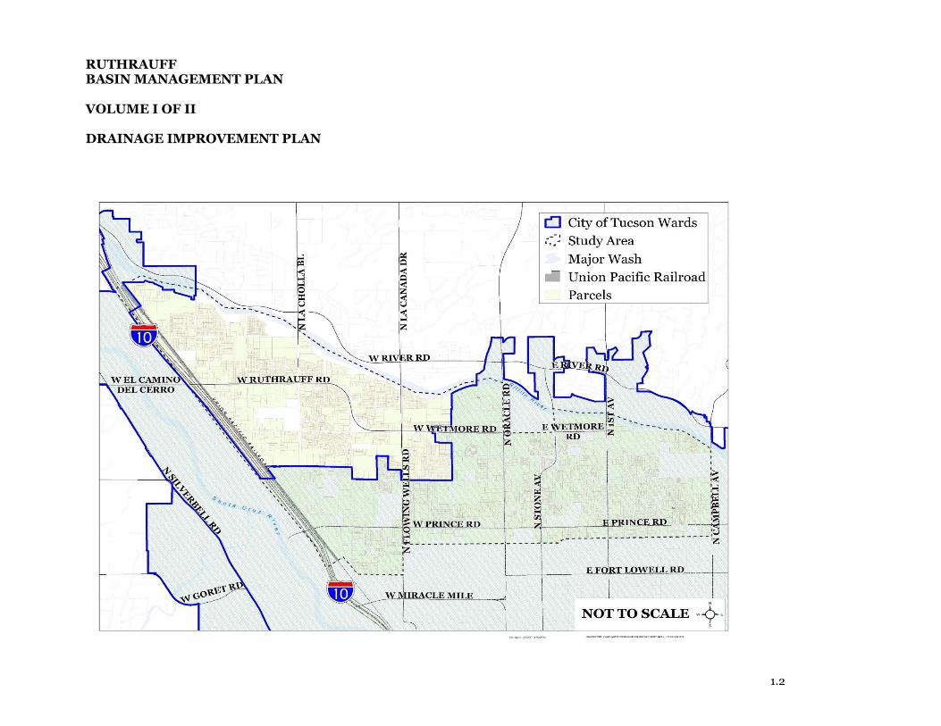
edge of the study area as highlighted in the reference map in Figure 1.
Some of the recommendations of the 1981 study have been adopted including a storm
drain along Ruthrauff Road. However, there are still areas mapped as FEMA (Federal
Emergency Management Agency) or local administered floodplains along the UPRR.
Flooding in the area between Prince Road and Ruthrauff Road comes from both the
Flowing Wells Wash and the Ruthrauff Basin (AECOM, 2011). The Flowing Wells Wash
from approximately 500 feet east of the railroad to the railroad does not have capacity for
the 100-year event. A portion of the conveyed discharge overtops the channel that conveys
Flowing Wells Wash (concrete lined channel) and the overtopped portion proceeds along
the railroad to the northwest and combines with runoff from the Ruthrauff Basin.
As part of the ADOT widening of lnterstate 10 between Prince Road and Ruthrauff Road
(2011-2014), drainage under the freeway was improved but some of the drainage across
the UPRR was not. This will eventually require additional outlets for the water during
flood events to be conveyed under the railroad tracks and enter the improvements
constructed during the Interstate 10 widening which will reduce the potential for ponding
against the UPRR. There have been four drainage improvements at the UPRR proposed:
at the Flowing Wells Wash, at the west end of Gardner Lane, and west of North Highway
Drive between West Zinnia Avenue, due north of Ruthrauff Road, and West Verbena
() Stantec

RUTHRAUFF BASIN MANAGEMENT PLAN VOLUME I OF II DRAINAGE IMPROVEMENT PLAN
1.2
Avenue. As of the writing of this report only one, a culvert at Flowing Wells Wash, has
been constructed.
In May of 2014, the Pima County Regional Flood Control District (PCRFCD) contracted
with Stantec Consulting Services Inc. (Stantec) to provide a professional consulting
engineering team (i.e., Stantec, JE Fuller Hydrology and Geomorphology Inc. and Wheat
Design Group) to develop a plan, that: identified flood hazard areas using improved
topographic information and new hydraulic modeling technics (i.e., two dimensional
modeling), collected drainage compliant reports, reviewed drainage problems, and
identified cost-effective solutions to alleviate or manage flooding in the study area. The
plan incorporates all the existing stormdrains constructed along the railroad.
The purpose of the RBMP was to develop a comprehensive flood control protection
program and to develop drainage alternatives which will improve public safety, provide
fiscal responsibility, and provide a balanced multi-objective approach toward managing
the watersheds, floodplains, and resources in the study area. The Ruthrauff basin is
developed (e.g., commercial, industrial, residential…etc.) but the basin has been the
target of a recent comprehensive plan amendment (Co7-08-01, Res. No. 2009-63), which
will allow Pima County to initiate infill incentives along Highway Drive including
development of a comprehensive flood control plan.
Once adopted by the Board of Supervisors and the City Council, this plan will provide
guidance for development, redevelopment and retrofits in flood prone areas as well as
drainage alternatives to further limit the potential for flooding. This study relied on
interagency coordination to preserve the hydrologic integrity and storm water conveyance
ability of the regional watersheds. The adoption of this study will ensure that the
floodplain management regulations will balance competing residential community and
private sector interests.
1.2 Project Scope
Stantec performed an existing conditions hydrologic and hydraulic analysis that
incorporated recent drainage improvements within the study area, and identified areas of
flooding and drainage conflicts. Currently available regulatory discharge values were
identified at selected locations for future development and improvements, as applicable
and/or for comparison to the hydraulic modeling completed for this basin management
() Stantec

RUTHRAUFF BASIN MANAGEMENT PLAN VOLUME I OF II DRAINAGE IMPROVEMENT PLAN
1.3
plan. The results of the analysis concluded that the existing floodplain mapping needed
to be re-delineated (see Section 4.0) for a portion of the area.
The project included an alternatives analysis and remediation recommendations. The
alternatives analysis for the study area was used to identify flood hazard solutions based
on the data gathered (e.g., drainage complaints, hydraulic analysis, existing and planned
improvements…etc.) and produced during the project. Remediation methods included
both structural and non-structural approaches for mitigating the floodplain conflicts
identified during the existing conditions analysis that include ranking by weighted
performance criteria and cost effectiveness.
The RBMP included extensive public and stakeholder involvement and required
dissemination of information, direct involvement (e.g., public meetings), and
comprehensive stakeholder coordination for all elements of the Ruthrauff Basin
Management Plan.
As part of the RBMP, Stantec prepared an Implementation and Maintenance Plan (see
Volume II of II). This is the plan for moving forward with the funding, scheduling, and
construction of the remediation recommendations contained within this report. Residing
within the Implementation and Maintenance Plan is a plan for identifying, scheduling,
and performing maintenance on existing and proposed drainage infrastructure.
1.3 Study Area
The RBMP study area is a 5440-acre (i.e., 8.5 square miles) urban area in east central
Pima County. Approximately 3155 acres, or 58%, of this area falls within Ward 3 of the
City of Tucson with the remaining portion of the study area located within unincorporated
Pima County. It is bounded on the southern edge by: West Fort Lowell Road between
Interstate 10 and North Flowing Wells Road, the Kleindale Road alignment between
North Flowing Wells Road and North Estrella Avenue, East Greenlee Road from North
Estrella Avenue to North Campbell Avenue. Interstate 10 marks the western edge and
North Campbell Avenue comprises the eastern study limit. The northern limit consists of
the southern bank of the Rillito River excluding the Tucson Mall property within the
northern half of Section 23, Township 13, Range 13 East (see Figure 1).
() Stantec

RUTHRAUFF BASIN MANAGEMENT PLAN VOLUME I OF II DRAINAGE IMPROVEMENT PLAN
1.4
The project area is generally located within portions of Sections 8, 15, 16, 17, 21, 23, 24,
25, 26, 27, and 28 of Township 13, Range 13 East and Sections 19 and 30 of Township 13,
Range 14 East.
1.4 Approximate Cost
The scope of this project included only preliminary design (15%) plans and therefore
engineering costs are highly estimated. However, estimates of the cost of construction for
the recommended alternatives (i.e., structural methods) were developed during the
prioritization phase for the purposes of priority ranking (see Section 5.2). These estimates
include an estimate of cost for construction only and do not include costs related to:
design, construction administration, contingency, property acquisition, agency
permitting/coordination nor environmental related expenses. It is recommended that a
more comprehensive analysis of all costs related to the execution of construction for the
individual alternatives be evaluated during a future project(s) as described in the
Implementation Plan (see Volume II of II).
1.5 Construction Schedule and Duration
Given their conceptual nature and the need to allocate funding there is no set construction
start date set for the recommendations resulting from this project. Additionally, until
funding is established for any or all the recommended alternatives and all final plans,
specifications, and opinions of the costs of construction are completed the duration of any
of the proposed improvements cannot be accurately estimated.
1.6 Project Disclaimer
The author of this document has taken all necessary steps and included various
assumptions that could be reasonably used without detailed discussions and/or review
periods that would normally be undertaken with all necessary State and/or Federal
agencies for a federally programmed project or one that requires direct coordination with
all necessary State, Federal or other local agencies and/or utility owners. This document
was prepared using current approaches, methodology, computations and standards of
care and practice; however, the author cannot guarantee that such may be the same at a
future date when funding has been established or when the final design phase
() Stantec

RUTHRAUFF BASIN MANAGEMENT PLAN VOLUME I OF II DRAINAGE IMPROVEMENT PLAN
1.5
commences. Therefore, at a future date this document may need to be reviewed and
revised as necessary to comply with all applicable criteria at that time.
All recommendations provided within this report will require complete engineering
design and other related services/efforts and approval by all appropriate agencies prior
to any construction activities. This document does not serve as project approval.
Information provided to Stantec by the PCRFCD is considered appropriate for use within
the nature of this study (i.e., conceptual) but will need to be reviewed and revised as
necessary prior to use within any subsequent design phases.
() Stantec

RUTHRAUFF BASIN MANAGEMENT PLAN VOLUME I OF II DRAINAGE IMPROVEMENT PLAN
1.0
Figure 1 – Project Map with Jurisdictions
RUTHRAUFF BASIN MANAGEMENT PLAN VOLUME I OF II DRAINAGE IMPROVEMENT PLAN
1.2

RUTHRAUFF BASIN MANAGEMENT PLAN VOLUME I OF II DRAINAGE IMPROVEMENT PLAN
2.1
2.0 Existing Conditions
The data for the analysis of the existing conditions within the Ruthrauff Basin was
collected from: the PCRFCD, the COT, the Arizona Department of Transportation
(ADOT), the UPRR, and other sources. The pertinent data was used to complete the
hydrologic and hydraulic modeling and facilitate the analysis of structural alternatives.
This information was gleaned from, but not limited to: as-built plans, existing
reports/data, land use plans, city and county reports, geotechnical data, and spatial data
(see Appendix B).
Additionally, there was a site visit conducted by the project team on July 10, 2014 with
representatives from: Stantec, JE Fuller Hydrology and Geomorphology Inc. (JEF),
PCRFCD, COT, and Wheat Design Group (WDG). JEF and WDG served as sub-
consultants to Stantec during project as did the Gordley Group (stakeholder involvement
task only). This field work allowed the team to understand the drainage problems more
fully, identify additional data needs, and initiate discussions relative to potential
alternative mitigation methods for future consideration. Photographs and observations
were used to document the 14 problem sites that were visited (see Appendix B.1.9).
2.1 Flooding and Drainage Problems within the Study Area
The 14 problem sites (i.e., isolated or individual locations) that were visited by the project
team were identified from a list of 13 problem areas (i.e., regional or sub-regional
locations) where existing chronic flooding and/or ponding problems were identified (see
Appendix B.2). These problem areas were recognized by reviewing drainage complaints
provided to Stantec by the County and the City (see Appendix B.1.10) as well as interviews
conducted with PCRFCD and COT maintenance and floodplain management personnel.
The drainage complaints, approximately 5,000 of them, were compiled from records
obtained from the PCRFCD, the COT, and ADOT over the span of last 20 years. The
complaints that had been resolved by improvements or were not located within the
designated RBMP study area were removed from further consideration. The remaining
complaints were plotted on a map (see Figure B.2) and used to identify areas of chronic
flooding (i.e., frequent flooding and/or potential for high depth of the flow) and/or
() Stantec

RUTHRAUFF BASIN MANAGEMENT PLAN VOLUME I OF II DRAINAGE IMPROVEMENT PLAN
2.2
drainage issues. On October 23, 2014 a stakeholders meeting was held where businesses
and neighborhood organizations helped to confirm the existence of those drainage
problems and further define the areas of interest (see Section 6.0). In addition, an open
house was held on December 14, 2014 to inform the public (i.e., homeowners, home
owner associations…etc.) of the purpose of the project and receive feedback concerning
ongoing drainage issues in the RBMP study area (see Section 6.0). During these outreach
efforts the public was encouraged to fill out comment forms which were used to confirm
the ongoing drainage issues (see Appendix F.1), identify any new concerns, isolate the
most significant problem areas, and begin a discussion of possible alternatives.
Additionally, following a request for the drainage complaints recorded in the study area,
ADOT staff indicated that the existing concrete barricades at the West Ruthrauff Road
underpass do not allow runoff to exit the roadway. The existence and locations of these
drainage problems were further verified by members of the public during two separate
outreach meetings; a stakeholders meeting on October 23, 2014 (see Section 6.2) and an
open house meeting held on December 14, 2014 (see Section 6.1).
() Stantec

RUTHRAUFF BASIN MANAGEMENT PLAN VOLUME I OF II DRAINAGE IMPROVEMENT PLAN
3.0 Hydraulic Analyses and Floodplain Delineation
A hydrology and hydraulic analysis was completed by JE Fuller Hydrology and
Geomorphology Inc. (JEF) to establish a current baseline model for the existing
conditions and to compare local floodplain limits within the RBMP study area with
effective information. Both analyses (i.e., hydrologic and hydraulic) were performed using
the computer program FLO-2D PRO using input parameters based on PCRFCD Technical
Policy 033, with some site specific considerations. The model was developed on a 15-ft
grid which allowed flow from impervious surfaces like rooftops and roadways to be shown
in detail. These models required the use of such parameters as rainfall, topography, soil,
vegetation, land use characteristics and runoff coefficients to determine excess runoff
volume totals and flood depths. The models were validated by comparing with a HEC-1
model (see Appendix C) because gauge data was not available for the study area.
The analysis included the 10-, 25-, and 100-year recurrence events, with a 3-hour rainfall
duration. Resulting flood depths as well as the 100-year discharges and velocities for
existing conditions within RBMP study area are included within the Ruthrauff Basin
Management Plan Technical Data Notebook for Hydrologic Analysis & Floodplain
Mapping (see Appendix C). The computer models prepared and the resulting maps (e.g.,
flood depths and limits) produced within the referenced report were used by the project
team to consider the new floodplain limits, assess potential problem areas, and initiate
discussions for remediation. In the alternatives phase these models were modified to
analyze the effectiveness of the structural alternatives’ ability to reduce flooding and
resolve noted drainage issues.
() Stantec

RUTHRAUFF BASIN MANAGEMENT PLAN VOLUME I OF II DRAINAGE IMPROVEMENT PLAN
4.0 FEMA Floodplain Map Revision
In November of 2016, JEF, acting as a sub-consultant to Stantec as a part of the RBMP,
submitted a Letter of Map Revision (LOMR) to the Federal Emergency Management
Agency (FEMA) for the Flowing Wells Wash and Runway Drive Area (Case No. 17-09-
0333P). The purpose of the LOMR is to revise the 1988 Flood Insurance Rate Maps
(FIRM) for Panel Numbers 04019C2277L, 04019C2279L, and 04019C2283L based on
structural drainage improvements and better hydraulic modeling method(s). The study
was performed in accordance with FEMA Guidelines; HEC-RAS version 4.1 was used to
model the hydraulics of the Flowing Wells Wash and FLO2D which has been approved
for modeling in Pima County, was used to perform the hydraulic and hydrologic analysis
for the Runway Drive area. The full results of the LOMR submittal document including
the annotated FEMA panels can be viewed in the Technical Data Notebook: Letter of Map
Revision for Flowing Wells Wash & Runway Drive Area (see Appendix D). At the time
of this report the LOMR is still under review by FEMA.
() Stantec

RUTHRAUFF BASIN MANAGEMENT PLAN VOLUME I OF II DRAINAGE IMPROVEMENT PLAN
5.0 Alternatives Analysis and Remediation Recommendations
The data collected within the RBMP study area included previous studies, previous and
new computer hydraulic and hydrologic modeling, and input from the public outreach
efforts, that were used to determine areas of flooding as well as nuisance ponding and
other drainage issues (e.g., connectivity, diversions, capacity…etc.). This information was
used to identify the top nine individual problem areas (see Table 1) of chronic drainage
issues and evaluate remediation alternatives, both structural and non-structural, for each
of them. In addition, basin-wide alternatives that would be effective in reducing the
drainage problems within the Ruthrauff Basin were also developed. All the alternatives
were then subjected to a prioritization scoring process. Out of this process a total of 18
recommended remediation alternatives, both structural and non-structural, resulted
from the nine identified problem areas as well as seven basin-wide recommendations.
The Recommended Alternatives Report (see Appendix E) details this development.
5.1 Alternatives Development Process
The development of the alternatives began with evaluation of a review of reported
drainage complaints (see Section 2.0) in conjunction with analysis of the existing
drainage conditions within the RBMP study area (see Section 3.0).
The result of these efforts was the identification of nine problem areas, within the overall
study area, of recurring or chronic issues where structural and non-structural alternatives
were of the greatest need. These areas were mapped based on the relative density (i.e.,
number in a given area) of complaints, both ponding and uncategorized. Table 1 lists these
nine problem areas along with the general problem statement of each area, and a
description of area’s boundary.
() Stantec

RUTHRAUFF BASIN MANAGEMENT PLAN VOLUME I OF II DRAINAGE IMPROVEMENT PLAN
Table 1 – Alternative Development Problem Areas
Problem Area No.
Existing Problem Statement Problem Area Boundary*
1 Ponding and flooding issues in
low lying areas.
West Curtis Road [S]
North Highway Drive and North Camino de la Tierra [W]
North Shannon Road [E]
Rillito River [N]
2 Poor drainage and ponding
issues.
West Gardner Lane [S]
UPRR [W]
Varies: North la Cholla Boulevard, North Plum Avenue and North Kain Avenue [E]
Ruthrauff Road [N]
3 Drainage and ponding issues with houses at grade and un-
improved streets.
West Gardner Lane [S]
North la Cholla Boulevard [W]
Romero Road [E]
West Wetmore Road [N]
4 Street flooding and property
erosion along Pomona Avenue.
West Wetmore Road [S]
Ruthrauff Road [W]
North Flowing Wells Road [E]
Rillito River [N]
5 Ponding issues in the
neighborhood east and north of Pelaar Street.
West Prince Road [S]
North Flowing Wells Road [W]
North Fairview Avenue [E]
West Roger Road [N]
6 Flooding issues because of existing culvert frequently
blocked with debris.
General area surrounding the intersection of: West Fort Lowell Road
and North Flowing Wells Road
7 Ponding and lot drainage
problems.
West Roger Road [S]
North Stone Avenue [W]
North 4th Avenue [E]
West Wetmore Road [N]

RUTHRAUFF BASIN MANAGEMENT PLAN VOLUME I OF II DRAINAGE IMPROVEMENT PLAN
Problem Area No.
Existing Problem Statement Problem Area Boundary*
8 Ponding issues caused by blocked existing drainage
structures.
General area surrounding the intersection of: West Roger Road at
North Tyndall Avenue
9
Erosion problems and nuisance ponding in Richland
Heights neighborhood (un-paved roads).
East Kleindale Road [S]
North Mountain Avenue [W]
North Martin Ave [E]
East Prince Road [N] *the definition of “boundary” for this project may include area(s) adjacent to the limits shown for each problem area.
With the selection of the most urgent problem areas completed, the development of the
alternatives best suited for these areas began. The alternatives selection process relied
heavily on stakeholder outreach. On February 8, 2016 a workgroup meeting was convened
that involved project team members and stakeholders from the county, city, and
neighborhood organizations (see Section 6.4.2). The members of this workgroup were
broken up into two teams with a facilitator and a “seedlist” for brainstorming viable ideas
for alternatives in each problem area as well as for the RBMP study area termed as “basin-
wide alternatives”. This process resulted in two comprehensive lists of alternatives to be
considered which the project team, in consultation with PCRFCD, combined into a single
list, by area, of 31 possible alternatives (see Appendix E).
The ideas that came out of the February workgroup meeting were first classified as
structural or non-structural alternatives and developed accordingly. The structural
alternatives included channels, detention/retention basins, storm drains, and roadway
improvements and were all designed using calculations based on the information
developed for the existing conditions within the basin (see Section 2.0). In general, these
alternatives are:
1) Providing drainage through the railroad embankment.
2) Slowing water and reducing flood peaks at multi-use basins.
3) Conveying water in drainage channels.
RUTHRAUFF BASIN MANAGEMENT PLAN VOLUME I OF II DRAINAGE IMPROVEMENT PLAN
4) Conveying water in stormdrains.
5) Improving roadways to better convey water.
6) Applying practices across the basin that reduce potential for flooding.
Of the original 31 possible alternatives, six are non-structural methods and were classified
as area-specific or area-wide and researched on that basis. The result of the alternatives
development process, both structural and non-structural, were documented in a
memorandum that became the basis for the alternatives analysis phase of the project.
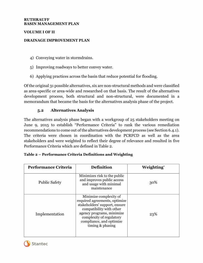
5.2 Alternatives Analysis
The alternatives analysis phase began with a workgroup of 25 stakeholders meeting on
June 9, 2015 to establish “Performance Criteria” to rank the various remediation
recommendations to come out of the alternatives development process (see Section 6.4.1).
The criteria were chosen in coordination with the PCRFCD as well as the area
stakeholders and were weighted to reflect their degree of relevance and resulted in five
Performance Criteria which are defined in Table 2.
Table 2 – Performance Criteria Definitions and Weighting
Performance Criteria Definition Weighting*
Public Safety
Minimizes risk to the public and improves public access
and usage with minimal maintenance
30%
Implementation
Minimize complexity of required agreements, optimize stakeholders' support, ensure
compatibility with other agency programs, minimize
complexity of regulatory compliance, and optimize
timing & phasing
23%

RUTHRAUFF BASIN MANAGEMENT PLAN VOLUME I OF II DRAINAGE IMPROVEMENT PLAN
Economic Vitality
Consistency with goals of PAG Vitality Advisory Committee and the City of Tucson Office
of Economic Initiatives.
17%
Performance Criteria Definition Weighting*
Community
Compatibility with known community or neighborhood historic values, goals, social
interactions, health and well-being, and the beneficial and multi-functional use of land
10%
Environmental
Sustainability
Preserve, protect, and enhance the land and water while promoting conservation,
multi-mode transportation, and minimizing the heat island
effect.
20%
* Out of a total score of 100%
The five weighted Performance Criteria were chosen to rank the recommended
alternatives. Individually these Performance Criteria were to be evaluated according to
between five and eleven weighted “Specific Criteria” and scored using detailed scoring
descriptions (see Appendix E). The scoring of the criteria, both performance and specific,
were based upon the evaluation of a scoring matrix (see Appendix E). The initial ranking
(i.e., order of priority) of both the recommended structural (see Section 5.2.1) and non-
structural (see Section 5.2.2) alternatives would rely upon these criteria. After the initial
ranking an opinion of the cost of construction was developed for each the alternatives, not
including the area-wide alternatives, and the resulting costs were used to develop a final
ranking.
A comprehensive cost/benefit analysis was not performed as part of this study.
5.2.1 Structural Alternatives Analysis
The structural alternatives were analyzed in several steps. The first step involved
conducting a fatal flaw analysis using hydraulic calculations. This eliminated several

RUTHRAUFF BASIN MANAGEMENT PLAN VOLUME I OF II DRAINAGE IMPROVEMENT PLAN
storm drains options (e.g., considering a new storm drain system when the existing
downstream system has no additional capacity) and potential roadway improvements
(e.g., curb and gutter at a location that would likely increase the potential for adjacent
flooding). The remaining alternatives were then hydraulically modeled to determine their
effectiveness on the extent and depth of flooding identified during the existing conditions
analysis (see Section 2.0). For several of the alternatives, only the performance of the
alternative, during the 10-year event, was considered as evaluation of a given alternative
during the 100-year was deemed impracticable based on engineering judgement and
regional experience. The resulting maps (i.e., depth grid comparison of pre-improvement
versus post-improvement conditions) can be found in Appendix E.
5.2.2 Non-Structural Alternatives Analysis
The first step in the analysis of the non-structural alternatives was to apply them to the
areas where they were needed the most. In doing this it was determined that all but one
of them, the Floodprone Land Acquisition Program (FLAP), could be applied to the
entirety of the RBMP study area. The FLAP program was particularly suited to the largely
commercial zone as is noted in the Recommended Alternatives Report (see Appendix E).
Additionally, a maintenance plan, though considered a basin wide alternative, was
deemed so crucial that warranted its own section in the RBMP Implementation Plan (see
Volume II). Documentation related to the other area-wide non-structural alternatives can
be viewed in Appendix E.
5.2.3 Alternatives Analysis Findings
Stantec developed a detailed description of each alternative including: estimate of
capacity, area requirements, resulting depth(s) of flow, connectivity, and land
acquisition…etc. and the findings of these report are included within the Recommended
Alternatives Report (see Appendix E).
5.3 Recommended Remediation Alternatives
Based on review of the findings for each alternative evaluated by Stantec in consultation
with PCRFCD and during several subsequent stakeholder meetings a list of the
recommended alternatives was developed. This list represents the alternatives that were
() Stantec

RUTHRAUFF BASIN MANAGEMENT PLAN VOLUME I OF II DRAINAGE IMPROVEMENT PLAN
deemed most practicable for each noted problem area and included some combinations
of several of the individual alternatives as explained in Section 5.2.1.
The recommended alternatives, including structural and non-structural, are summarized
in the following table. A more comprehensive table, including: additional alternative
details, performance and specific criteria scoring, rank based on scoring alone, and cost
data in included within Appendix E. An overall rank each of problem area and the
recommended alternative is shown within Table 3. Table 4 documents the ranking of the
basin wide alternatives.
Table 3 – Recommended Structural Alternatives
Problem Area No.
Alternative Overall
Rank (Priority)
1 Shannon Road – drainage channel east side of road to the Rillito River.
13
1
Camino de la Tierra - drainage channel on east side of road to the Rillito River with a retention basin and diversion channel system located to the north and east of Highway Drive.
10
2 Construct retention/detention basin at the site of the old airport runway
16
2 Channel system/network immediately east of I-10 between Gardner Lane and Ruthrauff Road
5
2 FLAP/Consolidate parcels for future private owner - Improvement District/Infill Development Incentives
7
2 Retention basin and diversion channel system – along/near Paradise Lane
12
2 Retention basin just south of Wetmore Road 17
2 Retention basin just west of Highway Drive 9

RUTHRAUFF BASIN MANAGEMENT PLAN VOLUME I OF II DRAINAGE IMPROVEMENT PLAN
Problem Area No.
Alternative Overall
Rank (Priority)
2 Retention basin and diversion channel at the east end of Verbena Avenue
14
3
Retention basin/roadway -- west of Romero Road: improve Root Lane with inverted crown cross section and install curb/gutter for additional conveyance to proposed retention basin at west end of Root Lance along with channel/outlet system
1
4 Retention basin and channel -- South of Rillito Street in conjunction with drainage channel on the west side of Flowing Wells to the Rillito River
2
4 Roadway/channel -- Inverted crown roadways, curb/gutter along: Pomona, Rillito, Ruth and Camino Aire Fresca (streets)
14
5 Retention basin - South of Pelaar Street 8
6 Repair channel tiles along Flowing Wells Wash 11
7 Retention basin – western edge of Don Hummel Park
2
8 Reconstruction - Intersection of Roger Road & Tyndall Avenue
4
8 Dry wells – install near intersection of Roger Road and Tyndall Avenue
6
9 Road Improvements - Greenlee Road, Vine Avenue, Kleindale Road, Cherry Avenue, Martin Avenue…etc.
18
*an exhibit was not prepared for this problem area as result of discussions with PCRFCD

RUTHRAUFF BASIN MANAGEMENT PLAN VOLUME I OF II DRAINAGE IMPROVEMENT PLAN
Table 4 – Recommended Non-Structural Alternatives
Area-Wide Alternative
Overall Rank
(Priority)
Declare entire project area a critical basin (i.e. new development to
reduce flows below predevelopment levels) 2
Regular maintenance and solutions regarding agency and residents'
cleaning vegetation from channels and enforcing vegetation removal in
channels crossing private land
5
Infill incentives 3
Public information/education/outreach campaign -- possibly in utility
bills (Tucson Clean and Beautiful) 1
GI/LID 4
Dry wells 6
Floodproofing 7
RUTHRAUFF BASIN MANAGEMENT PLAN VOLUME I OF II DRAINAGE IMPROVEMENT PLAN
6.0 Outreach
Public engagement was a crucial element of this project. Engagement included:
• Individual stakeholder meetings held with key agencies.
• Meetings with community leaders.
• Public Open House meetings were held at critical project milestones of the project
to both inform the public of the project’s goals and progress as well as to obtain
citizen feedback on the projects’ objectives and obtain witnessed events of flooding
and/or drainage issues and concerns.
• Workgroup sessions used to assemble and evaluate alternatives (both structural
and non-structural) considered within this project.
• Periodic project updates.
• A project website.
The following sections contain additional information regarding the type of and
information collected and disseminated at each outreach effort.
6.1 Public Open House Meetings
Two public open house meetings were held for the RBMP project at key milestones. The
first meeting was held during on December 14, 2014 during the initial phase of the project
(i.e., data collection period) to explain to the public the project’s goal and objective and to
gather feedback on drainage issues in this region. The second meeting was held on
November 16, 2016 to present to the public the preliminary findings of the project.
A detailed report of both public meetings was prepared for this task and is included within
Appendix F.4 and includes all citizen comment feedback forms collected.
() Stantec
RUTHRAUFF BASIN MANAGEMENT PLAN VOLUME I OF II DRAINAGE IMPROVEMENT PLAN
6.2 Stakeholder Involvement
The primary intent of the stakeholders’ meetings was for informational purposes.
Stakeholder involvement for this project included two presentations: the first held on July
23, 2014 to all public sector stakeholders (e.g., PCRFCD, Stantec, COT, ADOT, Pima
County…etc.) and the second was held on October 23, 2014 and was open to all
stakeholders (e.g., citizens, homeowner associations, school districts…etc.).
6.2.1 Stakeholder Meeting 1: July 24, 2014
This was the first stakeholder meeting for the RBMP. The purpose of this session was to
familiarize the local government stakeholders with purpose, tasks, deliverables, and
schedule of the project. The format for the meeting was an informational presentation
followed by a discussion. The agenda and meeting summary for this stakeholder meeting
are included within Appendix F.1.
6.2.2 Stakeholder Meeting 2: October 23, 2014
This was the second and final stakeholder meeting. The attendees of this meeting were
stakeholders from school districts, utilities, and community organizations with the
purpose of dispensing information about the RBMP and receiving input from them. The
agenda, meeting summary, and relevant documents for this stakeholder meeting are
included within Appendix F.2.
6.3 Project Website
A project website detailing the elements, description, and the location of the Ruthrauff
BMP has been produced and maintained by PCRFD. Additional information available on
the website includes periodic project updates as well as public involvement to date and
completed project reports.
6.4 Project Updates
PCRFD has periodically released project updates to inform the public of the project
progress to date. There have been 4 updates:
• October 2014
() Stantec

RUTHRAUFF BASIN MANAGEMENT PLAN VOLUME I OF II DRAINAGE IMPROVEMENT PLAN
• December 2014
• November 2015
• November 2016
These project updates and their contents are documented in Appendix F.4.
6.5 Workgroups
In contrast to the stakeholder meetings, the workgroups primary purpose was direct
interaction and collaboration of stakeholders with the project team for improving aspects
of the RBMP. Workgroup meetings were held frequently to develop potential alternatives
to address flood and/or drainage problems within each critical area (see Section 5.1) and
to develop performance and specific criteria (see Section 5.2) used to score each potential
alternative.
6.5.1 Workgroup 1: June 6, 2015
This objective of this meeting, as described in Section 5.2, was to build a scoring system
for ranking the recommended alternatives. The agenda, meeting summary, and related
documents for this workgroup meeting are included within the Recommended
Alternatives Report (see Appendix E).
6.5.2 Workgroup 2: February 8, 2016
The second of the workgroup meetings involved producing a comprehensive list of
alternatives to consider for the RBMP (see Section 5.1). The agenda, meeting summary,
and related documents for this workgroup meeting are included within the
Recommended Alternatives Report (see Appendix E).
6.5.3 Workgroup 3: August 31, 2016
This was the last of the workgroup meetings after all the alternatives analysis and scoring
had been performed. It was intended to inform the stakeholders from government and
the neighborhoods of what the recommended remediation alternatives were and how they
() Stantec

RUTHRAUFF BASIN MANAGEMENT PLAN VOLUME I OF II DRAINAGE IMPROVEMENT PLAN
ranked per cost and criteria. The agenda and meeting summary for this workgroup
meeting are included within the Recommended Alternative report (see Appendix E).
Appendix A – References
Report on the Existing 100-year Flooding Conditions within the Gardner Lane Area:
City of Tucson Contract No. 0401-81, Cella Barr Associates; November 10, 1981
Hydrologic Investigation for Gardner Lane Area: City of Tucson Contract No. 0401-81,
Cella Barr Associates; June 3, 1981
Alternative Design Schemes for the Gardner Lane Area: City of Tucson Contract No.
0401-81, Cella Barr Associates; June 16, 1981
I-10 mainline Reconstruction Casa Grande – Tucson Highway (I-10) Ruthrauff to
Prince Road Final Drainage Report: ADOT Project No. 010 PM 252 H6241 01C, AECOM;
April 2011
Hydraulic analysis program (two dimensional modeling), FLO-2D, Pro Version (FLO-2D
Software Inc., Post Office Box 66, Nutrioso, Arizona.
Hydraulic analysis program (one dimensional river analysis), HEC-RAS, version 4.1
(Hydrologic Engineering Center, 609 Second Street Davis, California, January 2010).
Hydrologic analysis program, HEC-1 (Hydrologic Engineering Center, USACOE, June
1998)
Criteria for Two-Dimensional Modeling, Technical Policy, Tech-033, Pima County
Regional Flood Control District; August 1, 2013
() Stantec

RUTHRAUFF BASIN MANAGEMENT PLAN VOLUME I OF II DRAINAGE IMPROVEMENT PLAN
Comprehensive Plan Update, Pima Prospers, Planning and Zoning Commission Public
Hearing Draft, The Pima County Planning and Zoning Commission, File Number C07-13-
10, Resolution No. 2009-63; March 25, 2015
() Stantec

Ruthrauff Basin Management Plan Final Report Volume II of II
Implementation Plan
Stantec Prepared for:
~ 111
PIMA COUNTY FLOOD CONTROL
Pima County Regional Flood Control District
Prepared by: Stantec Consulting Services Inc. 5151 East Broadway Boulevard Suite 400
Tucson, Arizona 85711 Project # 181300392
September 11, 2017
'
Expires 12-31-1S

RUTHRAUFF BASIN MANAGEMENT PLAN FINAL REPORT VOLUME II OF II IMPLEMENTATION PLAN
i
Table of Contents – Volume II
EXECUTIVE SUMMARY ...................................................................................... III
ABBREVIATIONS .................................................................................................. V
1.0 PURPOSE ................................................................................................... 1.1
2.0 PROCESS ................................................................................................... 2.1
2.1 TECHNICAL SUMMARY ................................................................................................. 2.1
2.2 PRODUCTS ...................................................................................................................... 2.2 2.2.1 Benefits of Floodplain Mapping .................................................................... 2.2 2.2.2 Maintenance Plan .......................................................................................... 2.3
3.0 IMPLEMENTATION RECOMMENDATIONS .............................................. 3.1
3.1 IMPORTANCE OF PLAN ADOPTION BY JURISDICTIONS .......................................... 3.1
3.2 CAPITAL IMPROVEMENT PLAN FRAMEWORK ESTABLISHED ............................... 3.2
3.3 PHASING OF RECOMMENDED ALTERNATIVES: DOWNSTREAM TO
UPSTREAM ..................................................................................................................... 3.3 3.3.1 Problem Areas 1 & 2: North of Curtis Road, Highway Drive, Camino
de la Tierra, Emerald Avenue & South of Ruthrauff Road to Gardner Lane and South East along Runway Drive .................................................... 3.3
3.3.2 Transportation Projects which For Partnership in Perimeter Drainage Improvements ................................................................................................ 3.3
3.3.3 Problem Area 4: North of Ruthrauff Road and West of Flowing Wells Road ............................................................................................................... 3.4
3.4 INCENTIVIZE THE PRIVATE SECTOR WITH INFILL INCENTIVES ......................... 3.4
3.5 IMPROVING INTERNAL DRAINAGE TO PERIMETER DRAINAGE
IMPROVEMENTS ............................................................................................................3.7 3.5.1 Problem Areas 3 &5 North of Ft Lowell to Ruthrauff and West to
Flowing Wells ..................................................................................................3.7 3.5.2 Problem Areas 7, 8, & 9: North of Prince Road to the Rillito and East
of Flowing Wells..............................................................................................3.7
3.6 AREA-WIDE AND NON-STRUCTURAL ALTERNATIVES IMPLEMENTATION .........3.7
4.0 CONCLUSION ............................................................................................ 4.1
LIST OF APPENDICES
Appendix A – References Appendix B – Maintenance Plan Appendix C – Resolution for Adoption; Pima County Board of Supervisors Appendix D – Resolution for Adoption; City of Tucson Mayor and Council
() Stantec

RUTHRAUFF BASIN MANAGEMENT PLAN FINAL REPORT VOLUME II OF II IMPLEMENTATION PLAN
ii
Appendix E – Infill Incentives in Unincorporated Pima County Appendix F – Benefits of the Management Plan to the City of Tucson LIST OF EXHIBITS
Exhibit A – First Phase: Current Projects and Proposed Alternatives for Basin Drainage to Major Watercourses Exhibit B – Later Phases: Internal Structural Components
() Stantec

RUTHRAUFF BASIN MANAGEMENT PLAN FINAL REPORT VOLUME II OF II IMPLEMENTATION PLAN
iii
Executive Summary
The Implementation Plan for this project was conceived and completed with the goal of
maximizing implementation opportunities for the Recommended Alternative(s) of the
Ruthrauff Basin Management Plan (RBMP). The results of the completed study, the
Maintenance Plan, Infill Incentives and Implementation Recommendations are
summarized in this Implementation Plan which is Volume II of II of the RBMP. This is
the plan for moving forward with the funding, phasing, and construction of the
recommended alternatives contained within the RBMP as described in Volume I of II,
Drainage Improvement Plan.
The Implementation Plan has been developed iteratively and in cooperation with the
Pima County Flood Control District, the City of Tucson, stakeholders, and other
cooperating agencies. It lays out a path for implementation of non-structural and area-
wide improvements that can begin at adoption and Capital Improvement Projects that
begin at the downstream edge of the basin.
The Recommended Alternatives for this project are comprised of structural and non-
structural solutions at various locations. These locations are distributed throughout the
project area and include construction and non-construction activities that will ultimately
be funded in one of three ways:
1) Solely funded by the District or the City of Tucson.
2) Funded solely or in partnership among private and/or public agencies
including the District and/or the City of Tucson.
3) Funded solely or in partnership among private and/or public agencies not
including the District.
The Recommended Alternatives were developed after extensive technical review of the
drainage infrastructure and land use conditions in the project area. Significant effort was
also put forth by the project team to involve the general public, as well as public and
private sector stakeholders, in development of the Recommended Alternatives. Included

RUTHRAUFF BASIN MANAGEMENT PLAN FINAL REPORT VOLUME II OF II IMPLEMENTATION PLAN
iv
within Volume I of II of the RBMP report is documentation of the public and stakeholder
activities and responses.
The Implementation Plan does not represent a binding legal agreement on any partners,
but does provide a solid summary of implementation efforts to date, as well as a roadmap
for the Pima County Regional Flood Control District to implement future aspects of the
RPMP. Often the schedule or funding for improvements will drive the implementation
timeline and recognition of this fact by the District and planning for this in future follow
through efforts will allow for cost effective and efficient construction completion.
() Stantec

RUTHRAUFF BASIN MANAGEMENT PLAN FINAL REPORT VOLUME II OF II
IMPLEMENTATION PLAN
v
Abbreviations
Units
cfs cubic feet per second
F degrees Fahrenheit
ft Feet
in Inch
lbs Pounds
mi Mile
sq.ft. square feet
Agencies, Firms, misc.
ADOT Arizona Department of Transportation
FIRM Flood Insurance Rate Map
FLAP Floodprone Land Acquisition Program
FEMA Federal Emergency Management Agency
GI/LID Green Infrastructure/Low Impact Development
CIP Capital Improvement Plan
COT City of Tucson
CBC Concrete Box Culvert
I-10 Interstate 10
JEF JE Fuller Hydrology and Geomorphology Inc.
LOMR Letter of Map Revision
NFIP National Flood Insurance Program
PCDOT Pima County Department of Transportation
PCRFCD Pima County Regional Flood Control District
RBMP Ruthrauff Basin Management Plan
RTA Regional Transportation Authority
Stantec Stantec Consulting Services Inc.
TSMS Tucson Stormwater Management Study
UPRR Union Pacific Railroad
WDG Wheat Design Group
() Stantec

RUTHRAUFF BASIN MANAGEMENT PLAN FINAL REPORT VOLUME II OF II
IMPLEMENTATION PLAN
2.1
1.0 Purpose
The purpose of the implementation plan is to lay out a strategy for implementing
the recommended alternatives, including both non-structural and structural, area-wide
and problem area specific drainage solutions.
2.0 Process
The project team reviewed the existing conditions drainage constraints, recommended
alternatives and the institutional desires described in FNWACC-prepared documents,
and Pima Prospers to develop an implementation plan.
Historically, flood flows pond on the west side of the basin due to the embankment of the
Union Pacific Railroad which is located immediately east of Interstate 10. A lack of
adequate drainage from the east of the Union Pacific Railroad line to the Santa Cruz River
was highlighted repeatedly as the ultimate source of the flooding problems on the western
edge of the study area. This provided a basis for beginning drainage improvements, at the
downstream end of the watershed and moving upstream
The Ruthrauff basin is developed (e.g., commercial, industrial, residential…etc.) and has
been the target of a recent comprehensive plan amendment (Co7-08-01, Res. No. 2009-
63), which will allow Pima County to initiate infill incentives districts including
development of a comprehensive flood control plan that addresses the chronic ponding
and flooding up against the railroad embankment on the western edge.
2.1 Technical Summary
Stantec Consulting Services Inc. (Stantec) provided professional consulting engineering
services to develop a plan, that: identified flood hazard areas using improved topographic
information and new hydraulic modeling technics (i.e., two-dimensional modeling),
collected drainage compliant reports, reviewed drainage problems, and identified cost-
effective solutions to alleviate or manage flooding in the study area.
() Stantec

RUTHRAUFF BASIN MANAGEMENT PLAN FINAL REPORT VOLUME II OF II
IMPLEMENTATION PLAN
2.2
The available data and results of this comprehensive analysis and recommended
alternatives are accessible in the RBMP Volume I of II. In real terms, Volume I of II lays
out the drainage problems and solutions.
2.2 Products
Volume II of II of the Ruthrauff Basin Management Plan focused on the steps needed to
implement the solutions to the drainage problems. Accompanying this Implementation
plan is a Maintenance Plan designed as a roadmap for building a maintenance program
as well as estimated costs for specific Recommended Alternatives set forth in the RBMP
Volume I. The implementation plan also includes an Infill Incentives Plan to describe
how redevelopment, as identified by the Flowing Wells Neighborhood Association
revitalization plan, can occur in the unincorporated Pima County portions of the study.
2.2.1 Benefits of Floodplain Mapping
Hydrologic and hydraulic analysis of the Ruthrauff Basin determined that the
existing FEMA floodplain mapping needed to be re-delineated for the area south of Gardner Lane, east of I-10, west of Romero Road, and north of Flowing Wells Wash,
especially considering the improved conveyance at the Flowing Wells Wash through the
railroad embankment south of Prince Rd. In November of 2016, JEF, acting as a sub-
consultant to Stantec as a part of the RBMP, submitted a Letter of Map Revision
(LOMR) to the Federal Emergency Management Agency (FEMA) for the Flowing Wells
Wash and Runway Drive Area (Case No. 17-09-0333P). The purpose of the LOMR is to
revise the 1988 Flood Insurance Rate Maps (FIRM) for Panel Numbers 04019C1667L,
and 04019C1669L based on structural drainage improvements, updated
topography, and better hydraulic modeling method(s). At the time of this report the
LOMR effective date is still pending.
The results of the LOMR indicated a dramatic reduction in floodplain limits which will
result in more developable property in the remapped area. The advantages of
the remapping are summarized in the benefits identified by the City of Tucson (see
Appendix F).
The data provided to the PCRFD from the RBMP will be made available to the City of
Tucson GIS staff to update local floodplain themes on Map Tucson for use by private
and public development.
() Stantec

RUTHRAUFF BASIN MANAGEMENT PLAN FINAL REPORT VOLUME II OF II
IMPLEMENTATION PLAN
2.3
2.2.2 Maintenance Plan
As part of the RBMP, Stantec prepared a Maintenance Plan (see Appendix B). Residing
within the Implementation and Maintenance Plan is a guideline for identifying,
scheduling, and performing maintenance on existing and proposed drainage
infrastructure. It is intended as a guideline only for persons and entities seeking direction
in developing maintenance plans and preliminary costs for drainage facilities within the
Ruthrauff Basin.
The cost estimates are presented as annual and lifetime costs. The lifecycle for all the
recommended alternatives was estimated to be 50 years. As this is just a preliminary
estimate there was no adjustment for future inflation. Inspection and maintenance
activities were broken down on a per unit basis. The costs of inspections were estimated
by unit duration and the costs of maintenance activities were estimated to be 5% of the
original cost of construction annually. The unit costs include labor, equipment, fuel,
permits and supplies. Each of those separate tasks would have to be broken down
individually for any comprehensive maintenance plan that would be developed for post-
construction support of any specific alternative. The cost breakdowns and lifetime cost
estimates can be viewed within the Maintenance Plan
() Stantec
RUTHRAUFF BASIN MANAGEMENT PLAN FINAL REPORT VOLUME II OF II
IMPLEMENTATION PLAN
3.1
3.0 Implementation Recommendations
3.1 Importance of Plan Adoption by Jurisdictions
The first step in the implementation of the Ruthrauff Basin Management Plan should be
the passing of resolutions adopting the plan by the jurisdictions which share the basin.
The RBMP is an organizational plan wherein the framework for a basin-wide stormwater
management program is established. Only a legislative body can commit funds to
implement this framework and adoption is the first step in this process. Adoption is
particularly useful in securing funding from certain state and federal programs as several
these programs require adoption for the reasons outlined above. This includes use of the
Plan in the eventuality of an emergency declaration and administration of the NFIP.
Adoption of the RBMP means that the technical data related to existing conditions, the
identification of potential flood hazards and the recommendations for remediation that
exist within the report has been accepted and can officially be used by the appropriate
agencies within jurisdictions to develop floodplain management protocol while
enhancing public safety, encouraging economic development, and ensuring fiscal
responsibility. It enables integrated regional planning for land use, infrastructure, and
water resources while encouraging a cooperative approach by the City and the County.
Adoption is required if recommendations in the RBMP are to be used by the Pima County
and the City of Tucson in a regulatory capacity as only a legislative body can approve
regulations for the public. Additionally, adoption of the plan sends a message to the
constituents of these jurisdictions, both residential and commercial, that their concerns
about drainage issues in the area are being addressed. This is especially true of the
FWNACC which has requested that Pima County and the City of Tucson work
collaboratively in the RBMP to develop drainage solutions.
Once adopted by the Board of Supervisors and the City Council, anticipated in the Fall of
2017, this plan will provide guidance for development, redevelopment, and retrofits in
flood prone areas as well as drainage alternatives to further limit the potential for
flooding. This study relied on interagency coordination to preserve the hydrologic
integrity and storm water conveyance ability of the Ruthrauff watersheds. The adoption
of this basin management plan will ensure that the floodplain management regulations
will balance competing residential community and private sector interests.
() Stantec

RUTHRAUFF BASIN MANAGEMENT PLAN FINAL REPORT VOLUME II OF II
IMPLEMENTATION PLAN
3.2
The Resolution for Adoption; Pima County Board of Supervisor is included in Appendix
C, and the Resolution for Adoption; City of Tucson Mayor and Council is included in
Appendix D.
3.2 Capital Improvement Plan Framework Established
One option for the implementation of the RBMP is through establishment of Capital
Improvement Plans (CIP). There are several projects being initiated on the western edge
of the basin that establish a good framework for such a plan. One of the biggest issues
plaguing the Ruthrauff Basin is the lack of drainage under the UPRR. While major
improvements to drainage under I-10 to the Santa Cruz River were completed many years
ago the lack of drainage infrastructure at the railroad right-of-way cause the tracks to act
as a linear embankment trapping the water before it can reach these facilities. These
projects seek to mitigate that problem by significantly improving conveyance to the Santa
Cruz.
The PCRFCD has contracted Kimley-Horn to design two culverts underneath the UPRR
that will take advantage of existing I-10 infrastructure. Both culverts, located at Gardner
Lane (see Appendix E, Exhibit 4, Volume II of II) and Zinnia Avenue (see Appendix E,
Exhibit 2, Volume II of II) to complement a culvert to be constructed along Highway
Drive, will bring improved drainage to Problem Area 2 identified in the Recommended
Alternatives Report (see Appendix E, Volume I of II). Additionally, slated for construction
in 2018, ADOT is in the planning the improvement of the I-10 interchange at El Camino
Del Cerro/Ruthrauff Road which will invariably include drainage upgrades.
These infrastructure improvements bring increased opportunity to “drain the tub”. The
improved ability to convey water out of the area creates an opportunity for CIP project
development. This approach can open many avenues for implementation funding
including private/public partnerships for economic development, Federal Community
Development Block Grants (CDBG), and sponsorships from other governmental
departments and agencies (ADOT, FHWA, etc.).
() Stantec

RUTHRAUFF BASIN MANAGEMENT PLAN FINAL REPORT VOLUME II OF II
IMPLEMENTATION PLAN
3.3
3.3 Phasing of Recommended Alternatives: Downstream to Upstream
The construction of needed conveyance improvement projects on the perimeter of the
Ruthrauff Basin (see Section 3.2) and connecter channels to link those projects will
enhance the ability for runoff to enter the major watercourses more easily. This would be
the beginning of the phasing for the implementation of the recommended alternatives.
Currently, as excess runoff flows toward the Santa Cruz on the western edge of the basin
and the Rillito on the northern edge, a lack of adequate conveyances causes the water to
pile up and flood streets and neighborhoods. Once this conveyance has been improved
the phased implementation of the recommended alternatives will alleviate the issues in
the problem areas. Exhibit A illustrates the improvements possible with implementation
and are described below.
3.3.1 Problem Areas 1 & 2: North of Curtis Road, Highway Drive, Camino de la
Tierra, Emerald Avenue & South of Ruthrauff Road to Gardner Lane and
South East along Runway Drive
As these problem areas are on the extreme western edge of the basin, and immediately
upstream of the Santa Cruz River, they would be included in the first phase of
implementation. Their proximity of the to I-1o and shopping areas north of the Rillito
make this a prime target for not only industrial but commercial and residential
redevelopment. Funding opportunities that exist for these areas can include a CIP area
that could encourage public/private partnerships.
3.3.2 Transportation Projects which For Partnership in Perimeter Drainage
Improvements
Exhibit A also notes that there is potential for drainage improvements associated with
planned transportation projects. ADOT is in the process of designing the Ruthrauff
Transportation Interchange (TI), slated for construction in 2018, which will include
drainage improvements. RFCD has been coordinating with ADOT in this process, which
should further improve drainage at the UPRR embankment on the Ruthrauff Rd.
alignment in Area 2. West of I-10 work is being completed to connect the outfall of
drainage from the Ruthrauff Basin into the Santa Cruz River which will enable full
function of projects in the problem areas including the Gardner Lane drainage
improvements.
() Stantec

RUTHRAUFF BASIN MANAGEMENT PLAN FINAL REPORT VOLUME II OF II
IMPLEMENTATION PLAN
3.4
In addition, Pima County Department of Transportation has plans to extend Sunset Rd
through drainage problem Area 1, and connect it to River Rd. This can be an opportunity
to implement drainage improvements associated along this proposed alignment.
3.3.3 Problem Area 4: North of Ruthrauff Road and West of Flowing Wells
Road
This area would also be included in the first phases of implementation. It is on the
northside of the basin and is therefore on the downstream edge of conveyance to the
Rillito River which would need to be improved concurrently with conveyance to the Santa
Cruz River. Improved drainage facilities in this area open the door for residential
revitalization by private developers attracted by the current relatively low property costs.
3.4 Incentivize the Private Sector with Infill Incentives
The development of Infill Incentives is another prospect for funding the implementation
of the RBMP through encouraged private sector participation in economic development
and community redevelopment to improve drainage to the perimeter public
improvements. The PCRFCD has initiated a tiered approach to Infill Incentives for parcels
under two (2) acres based upon the flow depths shown in the FLO-2D models for the basin
(see Appendix C, Volume I of II). The reasoning behind this is to remove roadblocks for
the redevelopment of smaller parcels where drainage studies can present a prohibitive
cost. Under this approach, a depth of flow of less than a foot in the 100-yr event would
not need a drainage report, a depth of flow of 1-2 feet in the 100-yr event would need to
consult with Flood Control and they would determine if a drainage engineering report is
necessary, and any depth of flow greater than two feet would require an engineering
drainage report. There are other requirements attached to each of these tiers that can be
viewed in Appendix E of this Implementation Plan.
The areas along Highway Drive and Garner Lane, because of their proximity to I-10 and
the relatively low value of the existing parcels, has been identified as a prime area for
redevelopment. Pima County has already taken the first steps toward establishment of an
Infill Incentive District by re-zoning the area for multi-use and green lighting its
development (Co7-08-01, Res. No. 2009-63). The primary proposed incentives along
() Stantec

RUTHRAUFF BASIN MANAGEMENT PLAN FINAL REPORT VOLUME II OF II
IMPLEMENTATION PLAN
3.5
Highway Drive involve providing private sector development with drainage corridors to
be able to connect with the planned publicly constructed drainage infrastructure under
the UPRR. The proposed channel improvements are available in Appendix E of this
Implementation Plan. The ability to keep water off property is a great incentive for private
development.
() Stantec

RUTHRAUFF BASIN MANAGEMENT PLAN FINAL REPORT VOLUME II OF II
IMPLEMENTATION PLAN
3.6
EXHIBIT A

Docu
ment
Path:
V:\52
813\a
ctive
\1813
0039
2\gis\
Altern
ative
s\mxd
_forF
inalR
eport
s_08
.28.20
17\P
hase
I_Curr
entP
rojs_
and P
ropos
edAlt
s_11
x17.m
xd
Date Saved: 9/11/2017 9:02:13 AM
!
!!
!!
!!
!
! ! ! ! ! ! ! ! ! ! !
!!
!!
!!
!!
!!
!!
!!!!!!!!!!!!!!!!!!!!!!!!!!!!!!!!!!!!!!!!!!!!!!!!!!!
!!
!!
!!
!!
!!
!!!!!!!
!!
!!!!!
!
!!!!!!!!!!!!!!!!!!!!
!!
!!
!!
!!
!!
!!!!!!!!!!!!!!!!!!
!!
!!
!!
!!
!
!
! !
!
!
!
!
!
!
!
!
!
!
!
!
!
!
!
!
!
!
!
!
!
!
!
!
!
!
!
!
!
!
!
!
!
!
!
!
!
!
!
!
!
!
!
!
!
!
!
!
!
!!
!
!
!
!
!
!
!
!
!
!
!
! !
!
!
!! ! ! ! ! ! ! ! ! ! ! ! ! ! ! ! !
!!
! ! ! ! ! !!
!!
!
! ! !
!!
!
! ! !!
! ! ! ! ! ! ! ! ! ! ! ! ! ! ! !!
!!
!
! !
!!
!
!
!!
!!!!!!!
!!
!!
!!
!!
!
!
!!
!! !
!!
!
!
!!
!!
!!
!
! ! !
!
!!
!!
!
!!!!
!!
!!
!!
!
!
!
!
!
!
!!
!!
!!
!!!
!!
!!
!!
! ! ! ! ! !!
!!
!
!
! !
!
!!
!
!
!!
!!
!!
!
! ! !
!
!!
!!
! ! !
!!
!!
!
!!!!
!!
!!
!
! !!
! !!
!!
!! !
!
!
! ! ! !
!!
!!
! !
!
! !
!
!!
!
!
!!
!!
!
!
!
!
!!!
! ! !!
!!
!!
!
!
!
!
! !!
!
!!
!!
!!
!
!
!
!
!!
!!
!! !
!!
!!
!!
! ! !
!!
!!
!
!!
!
!
!! !
!!
!
! ! ! ! !
!
! !
!!
!!
!!
!
!!
!!
!!
!!
!
!
! !
!!
! !!
!!
! ! ! ! ! !
!!
!!
!
! ! ! ! ! ! !
!
!
!
!
!
!
!
!
!
!
!
!
!
! !
!
!
!
!
!
!
!
!
!
!
!
!
!
!
!
!
!
!
!
!
!
!
!
!
!
!
!
!
!
!
!
!
!
!
!
!
!
!
!
!
!
!
!
!
!
!
!
!
!!
!
!
!
!!
!!
!!
!!
!
! ! ! ! ! ! ! ! ! ! ! ! ! ! ! ! ! ! !!
!!!
!
!!
!!
!!
!!
!!
!!
!!
!!
!!
!!!!!!
!!!!
!!
!!
!!
!!
!!
!!
!
! ! !!
!!
!!
!!
!!
!!
!!
!!
!!
!!
!!
!!
!!
!!
!!
!!
!!
!!
!!
!!
!!
!!
!!
!!
!!
!!
!!
!!
!!
!!
!!
!!
!!
!!
!!
!!
!!
!!
!!
!!
!!
!!
!!
!!
!
! ! ! ! ! ! ! ! ! ! ! ! ! ! ! ! ! ! !
!!
!!
!!
!!
!!
!!
!!
!!
!!
!!
!!
!!
!
!
!!
!!
!!
!!
!!
!!
!!
!
!!!!!!!!!!!!!!!!!!!!!!!!!!!!!!!!!!!!!!!!!!!!!!!!!!!!!!!
!!
!!
!!
! ! ! ! !
!!
!!
!!
!!
!!
!
!!!
!
!!!
!!
!!
!
!!!!!!!
!!
!!
!!
!!
!!
!!
!!
!!
!!
!!
!!
!!
!!
!
!
!!
!
!
!
!
!
!
!
!!
!!
!!
!!
!!
!!
!!
!!
!!
!
!!!
!
!
!!!!!
!!
!
! ! ! ! ! ! ! !
!
!
!
!
!!
!!
!
!!!!!!!!!!!
!!
!!
!!
!!!!!
!!
!!
!!
!!
!!
!!!!!!!!!!!!!!!!!!!!!!!!!!!!!!!!!!!!!
!!
!!
!!
!!
!!
!!
!!
!!
!!
!
!!!!!!!!!!
!!
!!
!
!!!!!
!!
!!
!
! ! ! ! !
!!
!!
!!
!!
!!
! !
!!
!
!!
!!
!
! !
! !
!
!
!
! !
!!
!!
!
!!!
!
! ! ! ! !
!!
!
!!!!
! ! !
!!
!!
!
! !
!!
!!
!
!
!!
!
! ! ! !
!!
!!
!!
!!
!!
!!
!!
!!
!!
!!
!!
!
!
!!
!!
!!
!!
!!
!!
!!
!!
!! ! ! ! ! !
!!
!!
!!
!!
!!
!!
!!
!!!
!!
!
!
!
!
!
!
!
!!
!!
!!
!!
!!
!!
!!
!!
!
! ! ! ! !
!!
!!
!
!
!
!
!
!
!
!
!
!!
!
!
!
!
!
!
!
!
!
!!
!
!
!
!!!!!
!!
!
!!!!!
!!
!!
!!
!!
!!
! ! ! ! !
!!
!!
!
! ! ! ! !
!
!
!
!
!
!
!
!!
!!
!!
!
!!
!
!
!
!
!
! !
!!
! ! ! !!
!
! ! !!
!
! !
!!
!!
!
! ! ! ! ! ! ! ! ! ! !!
!!
!!
!
!!
!!
!
!
!!!
!
!!
!!!!!
!
!
!
!
!
!
!
!
!
!
!
!
!
!
!
!
!
!
!
!
!
!
!
!
!
!
!
!
!
!
!
!
!
!
!
!
!
!
!
!
!
!
!
!
!
!
!
!
!
!
!
!
!
!
U NI O
N P A
CI F I C
R AI L R O
AD
1
23
4
5
W WETMORE RD
N FLO
WING
WEL
LS RD
W SWEETWATER DR
N LA
CHO
LLA BL
W EL CAMINO DEL CERRO W RUTHRAUFF RD
N LA
CAN
ADA
DR
N SILVERBELL RD
W RIVER RD
W RIVER RD
Gardner
W. Wetmore Rd
Rom
ero
Zinnia
Poppy
Lily
²1 inch = 1,250 feet0 1,250 2,500625
Feet
Union Pacific Railroad
!
!
!
!!
! Tucson City LimitsMajor WashStudy AreaRoadway Right-of-WayParcels
!"a$
!"a$
Alternative 2 - ChannelsRuthrauff UPRR Culverts
Problem Area 2:Problem Site 01/07/2016Flo 2D 100 yr Flood Limits 11/02/2015
W Sunset Rd
Curtis St
ADOT- Ruthrauff TIDrainage Improvements
PCDOT- Sunset RdDrainage Improvements
Alternative 1 - Concrete ChannelAlternative 2 - Earthen Channel
Basin
Problem Area 1:
Alternative 2 - Roadway Reconstruction
Alternative 1 - Earthen Channel Basin
Problem Area 4:
First Phase: Current Projects & Proposed Alternativesfor Basin Drainage to Major Watercourses

RUTHRAUFF BASIN MANAGEMENT PLAN FINAL REPORT VOLUME II OF II
IMPLEMENTATION PLAN
3.7
3.5 Improving Internal Drainage to Perimeter Drainage Improvements
These areas would be included in the next phase of implementation. With conveyance
improved downstream, the internal structural recommended alternatives in these areas
would be connected to that perimeter drainage. Examples of these kinds of projects are
shown in the following Exhibit B.
3.5.1 Problem Areas 3 &5 North of Ft Lowell to Ruthrauff and West to Flowing
Wells
There are opportunities in these areas for funding from other agencies (e.g. Pima County
DOT) that a CIP would encourage because of improved infrastructure and property
protection. Other improvements might be achieved as a condition of rezoning in
redevelopment.
3.5.2 Problem Areas 7, 8, & 9: North of Prince Road to the Rillito and East of
Flowing Wells
These areas would be included in later phasing of implementation. The internal structural
solutions in these areas would convey water north to the Rillito increasing property values
and public safety. These areas also would benefit from a CIP and perhaps public funding.
These might be able to be implemented as part of rezoning and redevelopment of parcels
in these areas.
3.6 Area-Wide and Non-Structural Alternatives Implementation
The implementation of the non-structural and area-wide alternatives can be phased
concurrently with the areal structural alternatives. Implementation of these alternatives
depend heavily on adoption of the RBMP by the jurisdictions of the basin.
In addition to infill incentives, and maintenance, described previously; recommended
area-wide solutions include public education on flood risk and flood safety, and
implementation of GI/LID features.
() Stantec

RUTHRAUFF BASIN MANAGEMENT PLAN FINAL REPORT VOLUME II OF II
IMPLEMENTATION PLAN
3.8
These area-wide solutions will require stakeholder collaboration, and funding such as
community development block grants (CDBGs) for implementation.
() Stantec

RUTHRAUFF BASIN MANAGEMENT PLAN FINAL REPORT VOLUME II OF II
IMPLEMENTATION PLAN
3.9
EXHIBIT B

Docu
ment
Path:
V:\52
813\a
ctive
\1813
0039
2\gis\
Altern
ative
s\mxd
_forF
inalR
eport
s_08
.28.20
17\La
terPh
ases
_Inter
nalSt
ructur
al_11
x17.m
xd
Date Saved: 8/31/2017 9:19:24 AM
!
!!
!!
!!
!
! ! ! ! ! ! ! ! ! ! !
!!
!!
!!
!!
!!
!!
!!!!!!!!!!!!!!!!!!!!!!!!!!!!!!!!!!!!!!!!!!!!!!!!!!!
!!
!!
!!
!!
!!
!!!!!!!
!!
!!!!!
!
!!!!!!!!!!!!!!!!!!!!
!!
!!
!!
!!
!!
!!!!!!!!!!!!!!!!!!
!!
!!
!!
!!
!
!
! !
!
!
!
!
!
!
!
!
!
!
!
!
!
!
!
!
!
!
!
!
!
!
!
!
!
!
!
!
!
!
!
!
!
!
!
!
!
!
!
!
!
!
!
!
!
!
!
!
!
!!
!
!
!
!
!
!
!
!
!
!
!
! !
!
!
!
! ! ! ! ! ! ! ! ! ! ! ! ! ! ! ! !
!!
! ! ! ! ! !!
!!
!
! ! !
!!
!
! ! !!
! ! ! ! ! ! ! ! ! ! ! ! ! ! ! !!
!!
!
! !
!!
!
!
!!
!!!!!!!
!!
!!
!!
!!
!
!
!!
!! !
!!
!
!
!!
!!
!!
!
! ! !
!
! !
!!
!
!!!!
!!
!!
!!
!
!
!
!
!
!
!!
!!
!!
!!!
!!
!!
!!
! ! ! ! ! !!
!!
!
!
! !
!
!!
!
!
!!
!!
!!
!
! ! !
!
!!
!!
! ! !
!!
!!
!
!!!!
!!
!!
!
! !!
! !!
!!
!! !
!
!
! ! ! !
!!
!!
! !
!
! !
!
!!
!
!
!!
!!
!
!
!
!
!!!
! ! !!
!!
!!
!
!
!
!
! !!
!
!!
!!
!!
!
!
!
!
!!
!!
!! !
!!
!!
!!
! ! !
!!
!!
!
!!
!
!!
! !!
!!
! ! ! ! !
!
! !
!!
!!
!!
!
!!
!!
!!
!!
!!
! !
!!
! !!
!!
! ! ! ! ! !
!!
!!
!
! ! ! ! ! ! !
!
!
!
!
!
!
!
!
!
!
!
!
!
! !
!
!
!
!
!
!
!
!
!
!
!
!
!
!
!
!
!
!
!
!
!
!
!
!
!
!
!
!
!
!
!
!
!
!
!
!
!
!
!
!
!
!
!
!
!
!
!
!
!!
!
!
!
!!
!!
!!
!!
!
! ! ! ! ! ! ! ! ! ! ! ! ! ! ! ! ! ! !!
!!!
!
!!
!!
!!
!!
!!
!!
!!
!!
!!
!!!!!!
!!!!
!!
!!
!!
!!
!!
!!
!
! ! !!
!!
!!
!!
!!
!!
!!
!!
!!
!!
!!
!!
!!
!!
!!
!!
!!
!!
!!
!!
!!
!!
!!
!!
!!
!!
!!
!!
!!
!!
!!
!!
!!
!!
!!
!!
!!
!!
!!
!!
!!
!!
!!
!!
!
! ! ! ! ! ! ! ! ! ! ! ! ! ! ! ! ! ! !
!!
!!
!!
!!
!!
!!
!!
!!
!!
!!
!!
!!
!
!
!!
!!
!!
!!
!!
!!
!!
!
!!!!!!!!!!!!!!!!!!!!!!!!!!!!!!!!!!!!!!!!!!!!!!!!!!!!!!!
!!
!!
!!
! ! ! ! !
!!
!!
!!
!!
!!
!
!!!
!
!!!
!!
!!
!
!!!!!!!
!!
!!
!!
!!
!!
!!
!!
!!
!!
!!
!!
!!
!!
!
!
!!
!
!
!
!
!
!
!
!!
!!
!!
!!
!!
!!
!!
!!
!!
!
!!!
!
!
!!!!!
!!
!
! ! ! ! ! ! ! !
!
!
!
!
!!
!!
!
!!!!!!!!!!!
!!
!!
!!
!!!!!
!!
!!
!!
!!
!!
!!!!!!!!!!!!!!!!!!!!!!!!!!!!!!!!!!!!!
!!
!!
!!
!!
!!
!!
!!
!!
!!
!
!!!!!!!!!!
!!
!!
!
!!!!!
!!
!!
!
! ! ! ! !
!!
!!
!!
!!
!!
! !
!!
!
!!
!!
!
! !
! !
!
!
!
! !
!!
!!
!
!!!
!
! ! ! ! !
!!
!
!!!!
! ! !
!!
!!
!
! !
!!
!!
!
!
!!
!
! ! ! !
!!
!!
!!
!!
!!
!!
!!
!!
!!
!!
!!
!
!
!!
!!
!!
!!
!!
!!
!!
!!
!! ! ! ! ! !
!!
!!
!!
!!
!!
!!
!!
!!!
!!
!
!
!
!
!
!
!
!!
!!
!!
!!
!!
!!
!!
!!
!
! ! ! ! !
!!
!!
!
!
!
!
!
!
!
!
!
!!
!
!
!
!
!
!
!
!
!
!!
!
!
!
!!!!!
!!
!
!!!!!
!!
!!
!!
!!
!!
! ! ! ! !
!!
!!
!
! ! ! ! !
!
!
!
!
!
!
!
!!
!!
!!
!
!!
!
!
!
!
!
! !
!!
! ! ! !!
!
! ! !!
!
! !
!!
!!
!
! ! ! ! ! ! ! ! ! ! !!
!!
!!
!
!!
!!
!
!
!!!
!!
!!
!!!!
!
!
!
!
!
!
!
!
!
!
!
!
!
!
!
!
!
!
!
!
!
!
!
!
!
!
!
!
!
!
!
!
!
!
!
!
!
!
!
!
!
!
!
!
!
!
!
!
!
!
!
!
!
!
U NI O
N P A
CI F I C
R AI L R O
AD
N 1STAV
N LA
CHOL
LA BL
W FORTLOWELL RD
W PRINCE RD
E WETMORE RD
E FORT LOWELL RD
E PRINCE RD
E RIVER RD
WRUTHRAUFF RD
W WETMORE RD
N OR
ACLE
RD
N 1S
T AV
N FLO
WING
WEL
LS RD
W PRINCE RD
N STO
NE A
V
3
5
7
8 E. Roger Rd
W Limberlost Rd
N Ty
ndall
Rd
²1 inch = 1,250 feet0 1,250 2,500625
Feet
!"a$
Later Phases: Internal Structural Components
Alternative 1 - Roadway and Stormdrain Improvements
Problem Area 8:
!
!
!
!!
! Tucson City LimitsStudy AreaMajor WashParcelsRoadway Right-of-WayUnion Pacific Railroad
Problem Site 01/07/2016Flo 2D 100 yr Flood Limits 11/02/2015
N M
ount
ain A
ve
N Ro
mer
o Rd
N Fa
irview
Ave
Alternative 1 - Inverted Crown Roadway Earthen Channel Basin
Problem Area 3:
Alternative 1 - BasinProblem Area 5:
Alternative 1 - BasinProblem Area 7:
RUTHRAUFF BASIN MANAGEMENT PLAN FINAL REPORT VOLUME II OF II
IMPLEMENTATION PLAN
4.0 Conclusion
In conclusion, the adoption of the Ruthrauff Basin Management Plan by the City of
Tucson and Pima County would greatly facilitate its implementation. As a framework for
recommended improvements it leaves open opportunities for improved economic and
community development without handcuffing public budgets. The proposed
improvements for conveyance under the UPRR to the Santa Cruz River opens the door to
a redevelopment. Implementation benefits the residents and property owners in the basin
who are looking for the tools of revitalization and avenues for reduced flood hazards and
related costs. The development of Capital Improvement Plans and Infill Incentives would
encourage private sector development as well as incentivize private/public partnerships.
Adoption of the RBMP would open opportunities for block grants and other sources of
funding and additional resources from local, state and federal agencies.
() Stantec

RUTHRAUFF BASIN MANAGEMENT PLAN FINAL REPORT VOLUME II OF II IMPLEMENTATION PLAN
Appendix A – References
Ruthrauff Basin Management Plan: Volume I of II, Stantec Consulting; February 14,
2017
Comprehensive Plan Update, Pima Prospers, Planning and Zoning Commission Public
Hearing Draft, The Pima County Planning and Zoning Commission, File Number C07-13-
10, Resolution No. 2009-63; March 25, 2015
Sunset Road – Silverbell Road to I-10, Pima County Transportation/RTA, Website; http://webcms.pima.gov/cms/One.aspx?pageId=66493
Comprehensive Plan Update, Pima Prospers, Planning and Zoning Commission Public
Hearing Draft, The Pima County Planning and Zoning Commission, File Number C07-13-
10, Resolution No. 2009-63; March 25, 2015
() Stantec