Embed Size (px)
Citation preview
POSEIDON NICKEL LIM ITED • Unit 8 • Churchill Court • 331-335 Hay Street • Subiaco • WA 6008 PO Box 190 • West Perth WA 6872 • T +618 6167 6600 • F +618 6167 6649 • www.poseidon-nickel.com.au • ABN 60 060 525 206
12th November 2015
Resource Estimate for the World’s Highest Grade Nickel Mine
Highlights
• Initial Mineral Resource Estimation for the high grade Silver Swan nickel mine completed
• Estimated Resource base for Silver Swan Nickel Deposit of:
− 106,600 tonnes @ 12.20% Ni for 13,000 tonnes of contained nickel
• Average grades are believed to be twice as high as the next highest grade mine in the World
• Restart study offtake and funding negotiations underway
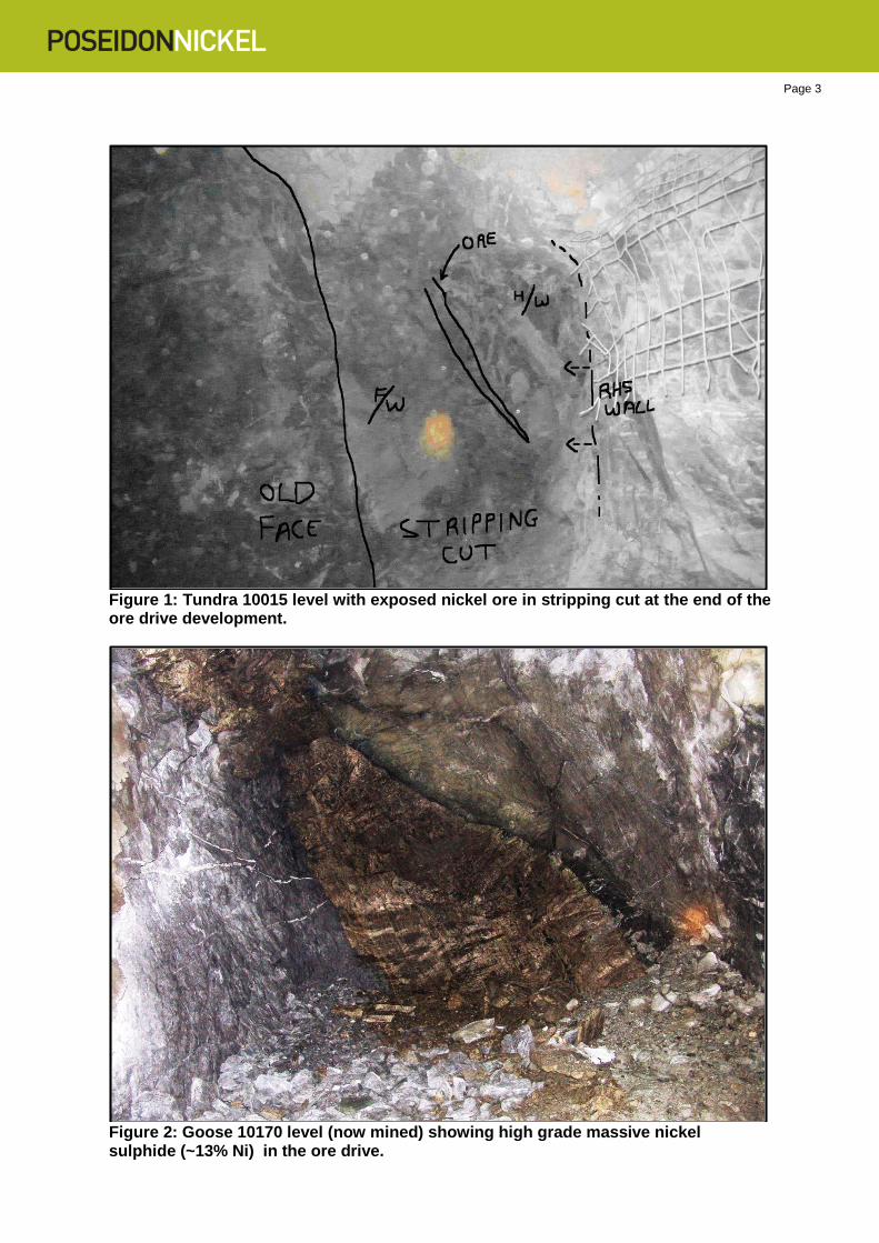
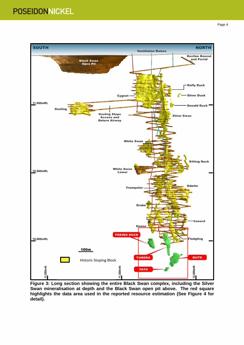
Poseidon Nickel Limited (ASX:POS) (“Poseidon”) is pleased to announce the first JORC 2012 compliant resource statement for the Silver Swan mine acquired in July 2015. Silver Swan is the highest grade, production nickel mine in the world with resource grades approximately twice that of the next highest resource. The ore produces a high quality smeltable concentrate and can be mined and flotation processed in conjunction with the company’s other nickel deposits. Importantly, Poseidon believes that the ore body can be economic even at low commodity prices. High grade extensions to the current resource are expected when further exploration drilling is completed underground. Whilst the mine is at circa 1,300 metres depth, the exceptionally high grades mean this mine will remain economic for several years at least. The mine infrastructure is in good condition and the ore bodies can be accessed from the existing decline. Poseidon is currently working on a detailed recommencement plan which will be announced to the market in the following weeks. In addition, negotiations for offtake of ore are well advanced and expected to complete shortly. Silver Swan has historically been the highest grade nickel mine in the World with resource grades typically in the range of 8% to 12% nickel with a historical production of 130Kt of nickel metal at an average grade of 5.2% nickel although this lower grade was representative of the bulk mining method used at the time. The resource estimation comprised unmined mineralisation between 1300m-1600m below surface. Underground mining operations by Norilsk Nickel were suspended just as the 10015 access drive had intersected mineralisation in the Tundra Deposit (Figure 1). Two other access drives (10030 & 10045) situated above the Tundra 10015 drive are within 4m and 8m respectively of the mineralisation which contains the majority of the Indicated Resource. An access drives to the bottom of the Goose Deposit (Figure 2) is 36m from mineralisation and access drives towards Peking Duck Deposit had also commenced (see Figures 3 & 4 below).
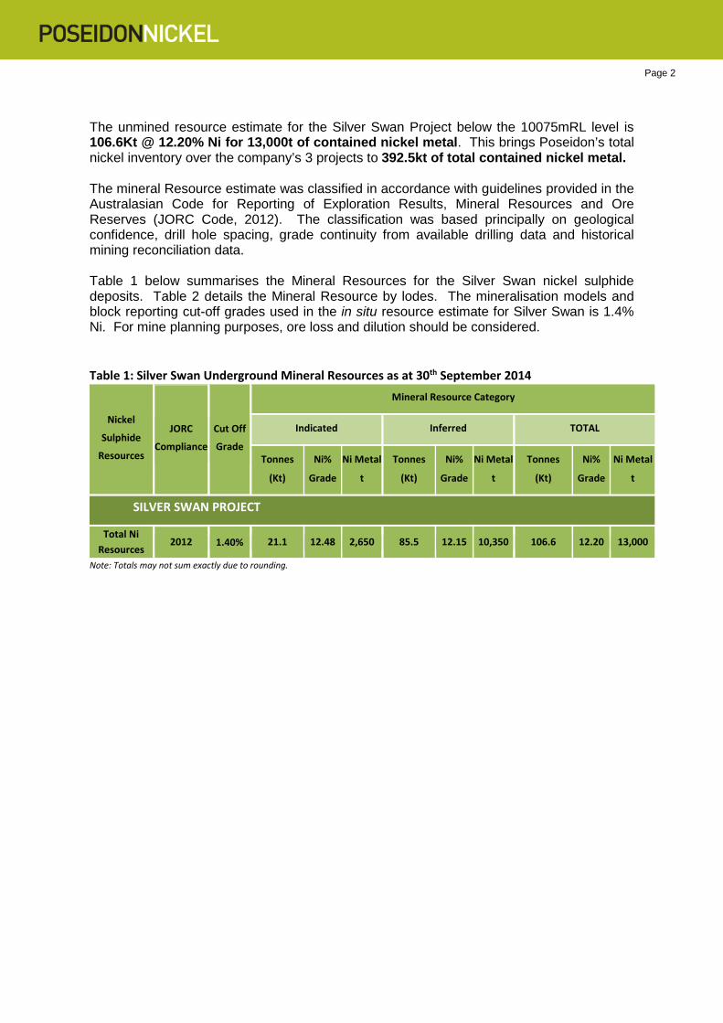
Page 2 The unmined resource estimate for the Silver Swan Project below the 10075mRL level is 106.6Kt @ 12.20% Ni for 13,000t of contained nickel metal. This brings Poseidon’s total nickel inventory over the company’s 3 projects to 392.5kt of total contained nickel metal. The mineral Resource estimate was classified in accordance with guidelines provided in the Australasian Code for Reporting of Exploration Results, Mineral Resources and Ore Reserves (JORC Code, 2012). The classification was based principally on geological confidence, drill hole spacing, grade continuity from available drilling data and historical mining reconciliation data. Table 1 below summarises the Mineral Resources for the Silver Swan nickel sulphide deposits. Table 2 details the Mineral Resource by lodes. The mineralisation models and block reporting cut-off grades used in the in situ resource estimate for Silver Swan is 1.4% Ni. For mine planning purposes, ore loss and dilution should be considered. Table 1: Silver Swan Underground Mineral Resources as at 30th September 2014
Nickel
Sulphide
Resources JORC
Compliance
Cut Off
Grade
Mineral Resource Category Indicated Inferred TOTAL
Tonnes
(Kt) Ni%
Grade Ni Metal
t Tonnes
(Kt) Ni%
Grade Ni Metal
t Tonnes
(Kt) Ni%
Grade Ni Metal
t SILVER SWAN PROJECT
Total Ni Resources 2012 1.40% 21.1 12.48 2,650 85.5 12.15 10,350 106.6 12.20 13,000
Note: Totals may not sum exactly due to rounding.
Page 3
Figure 1: Tundra 10015 level with exposed nickel ore in stripping cut at the end of the ore drive development.
Figure 2: Goose 10170 level (now mined) showing high grade massive nickel sulphide (~13% Ni) in the ore drive.
Page 4
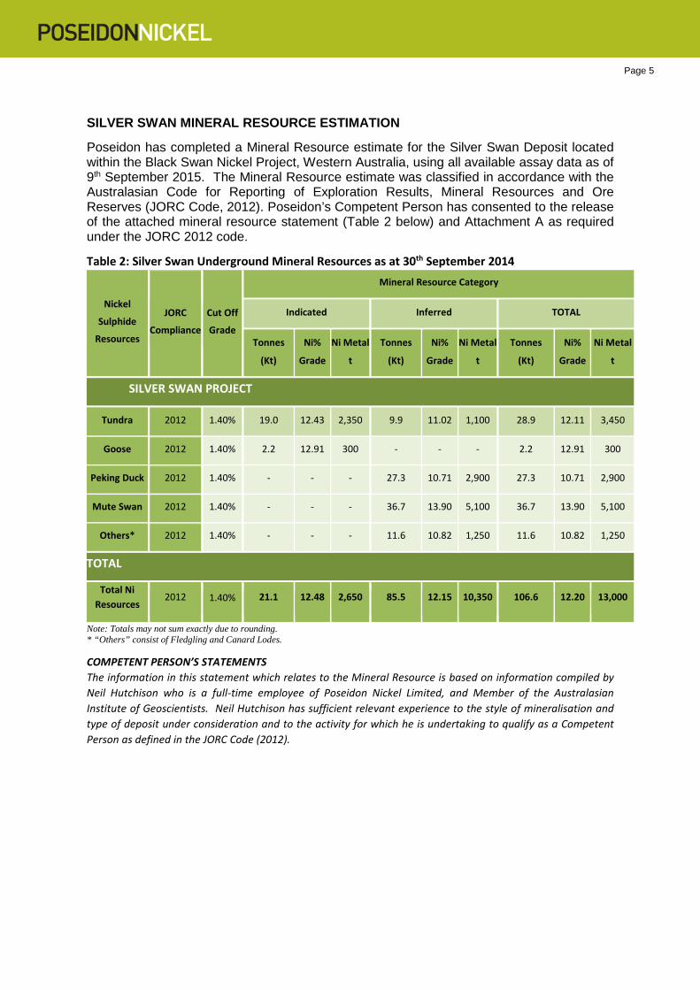
Figure 3: Long section showing the entire Black Swan complex, including the Silver Swan mineralisation at depth and the Black Swan open pit above. The red square highlights the data area used in the reported resource estimation (See Figure 4 for detail).
Historic Stoping Block
Page 5 SILVER SWAN MINERAL RESOURCE ESTIMATION
Poseidon has completed a Mineral Resource estimate for the Silver Swan Deposit located within the Black Swan Nickel Project, Western Australia, using all available assay data as of 9th September 2015. The Mineral Resource estimate was classified in accordance with the Australasian Code for Reporting of Exploration Results, Mineral Resources and Ore Reserves (JORC Code, 2012). Poseidon’s Competent Person has consented to the release of the attached mineral resource statement (Table 2 below) and Attachment A as required under the JORC 2012 code.
Table 2: Silver Swan Underground Mineral Resources as at 30th September 2014
Nickel
Sulphide
Resources JORC
Compliance
Cut Off
Grade
Mineral Resource Category Indicated Inferred TOTAL
Tonnes
(Kt) Ni%
Grade Ni Metal
t Tonnes
(Kt) Ni%
Grade Ni Metal
t Tonnes
(Kt) Ni%
Grade Ni Metal
t SILVER SWAN PROJECT
Tundra 2012 1.40% 19.0 12.43 2,350 9.9 11.02 1,100 28.9 12.11 3,450
Goose 2012 1.40% 2.2 12.91 300 - - - 2.2 12.91 300
Peking Duck 2012 1.40% - - - 27.3 10.71 2,900 27.3 10.71 2,900
Mute Swan 2012 1.40% - - - 36.7 13.90 5,100 36.7 13.90 5,100
Others* 2012 1.40% - - - 11.6 10.82 1,250 11.6 10.82 1,250
TOTAL
Total Ni Resources 2012 1.40% 21.1 12.48 2,650 85.5 12.15 10,350 106.6 12.20 13,000
Note: Totals may not sum exactly due to rounding. * “Others” consist of Fledgling and Canard Lodes. COMPETENT PERSON’S STATEMENTS The information in this statement which relates to the Mineral Resource is based on information compiled by Neil Hutchison who is a full-time employee of Poseidon Nickel Limited, and Member of the Australasian Institute of Geoscientists. Neil Hutchison has sufficient relevant experience to the style of mineralisation and type of deposit under consideration and to the activity for which he is undertaking to qualify as a Competent Person as defined in the JORC Code (2012).
Page 6
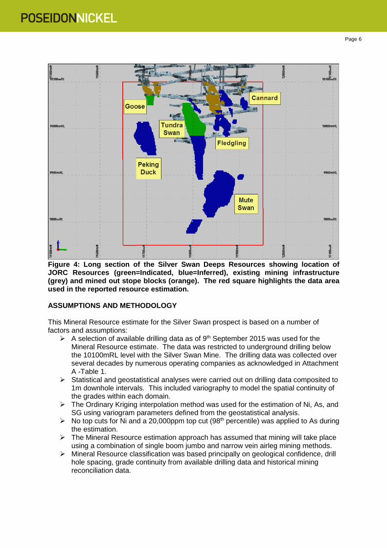
Figure 4: Long section of the Silver Swan Deeps Resources showing location of JORC Resources (green=Indicated, blue=Inferred), existing mining infrastructure (grey) and mined out stope blocks (orange). The red square highlights the data area used in the reported resource estimation. ASSUMPTIONS AND METHODOLOGY This Mineral Resource estimate for the Silver Swan prospect is based on a number of factors and assumptions: A selection of available drilling data as of 9th September 2015 was used for the
Mineral Resource estimate. The data was restricted to underground drilling below the 10100mRL level with the Silver Swan Mine. The drilling data was collected over several decades by numerous operating companies as acknowledged in Attachment A -Table 1.
Statistical and geostatistical analyses were carried out on drilling data composited to 1m downhole intervals. This included variography to model the spatial continuity of the grades within each domain.
The Ordinary Kriging interpolation method was used for the estimation of Ni, As, and SG using variogram parameters defined from the geostatistical analysis.
No top cuts for Ni and a 20,000ppm top cut (98th percentile) was applied to As during the estimation.
The Mineral Resource estimation approach has assumed that mining will take place using a combination of single boom jumbo and narrow vein airleg mining methods.
Mineral Resource classification was based principally on geological confidence, drill hole spacing, grade continuity from available drilling data and historical mining reconciliation data.
Page 7 Geology & Geological Interpretation Silver Swan is located within the Boorara Domain of the Kalgoorlie Terrane. There are two main lithological associations recognised; the Morelands and Gindalbie Formations. The Gindalbie Formation is of a felsic metasedimentary rock association and contains the Black Swan Komatiite Complex (BSKC). It also hosts the Kanowna Belle gold mine 25 km to the south of Black Swan. The Black Swan area is in the upper greenschist, lower amphibolite facies Boorara Domain. The major structural feature of this domain is the Kanowna–Scotia anticline, which has the BSKC on its east facing, east dipping limb. To the east of Black Swan, the Boorara Domain is separated from the Kurnalpi Terrane by the Mt Monger – Moriarty Shear and to the west it is separated from the Kambalda Domain by the Boorara Shear. Nickel sulphide mineralisation at Black Swan is hosted by the Black Swan Komatiite Complex (BSKC), a 3.5 km long by 0.6 km thick arcuate lens of olivine cumulate and spinifex-textured komatiite flows. The complex is enclosed within a broad NE dipping sequence of intermediate felsic lavas and associated volcaniclastics. Graphitic black shales have been recognised in the enclosing felsic sequence approximately 700 m above and below the BSKC. The BSKC and enclosing felsic volcanic sequence face and dip steeply towards the NE. Except for several small areas of sub-outcrop, a thin veneer of lateritic red soil covers the BSKC. Mineralisation at Black Swan occurs within the complex as massive, semi massive and disseminated nickel sulphides developed on and adjacent to the basal contact. The Silver Swan massive-sulphide nickel deposit consists of a series of steeply dipping lens-shaped shoots of mineralisation situated on the basal contact of the BSKC. Individual shoots include Silver Swan, White Swan, Goose, Fledgling, Canard, Odette, Trumpeter and Mute Swan. This mineralisation plunges steeply towards the north along the southern flank of a substrate topographical high, the Silver Swan footwall dome. Sampling and Sub-Sampling Techniques
Underground diamond drilling has been used to obtain core samples. Sampling is a mixture of full core, and half core sampling. In general, 1 m samples or smaller have been used for exploration and grade control drilling. Samples have been obtained from drilling carried out from underground drilling by LionOre and Norilsk Nickel Australia below the 10100mRL level. The drilling database and block model above this RL have been cut from the resource estimate data set as these have been mined out and are not reported in this document. Only drilling completed between 2006-2008 are included in the resource estimate. Diamond drilling sampling protocol has followed accepted industry practice, with all mineralised core sampled and intervals selected by geologists to ensure samples did not cross geological or lithological contacts. Core was halved, with a half sent for assay and the remaining core retained for geological reference. The entire deeper drill core used in this estimation was either full core or cut using a core saw, with half core used for sampling. Resource and grade control drilling was crushed to <3 mm and then split to 3 kg lots, then pulverised. This is appropriate given the sample interval and mass.
Page 8 Drilling Techniques Underground diamond drilling is the method by which drilling has been conducted into the ore zones below the 10100mRL level of the mine. The entire diamond core below the reported 10100mRL is of NQ size. Core orientation was carried out using the EzyMark system. All core trays are digitally photographed to maintain a permanent record of core prior to any sampling operations. Hard copy photographs exist for core photographed before the advent of digital photography. Criteria Used for Classification Resources were classified in accordance with the Australasian Code for the Reporting of Exploration Results, Mineral Resources and Ore Reserves (JORC Code, 2012 Edition). The classification of Mineral Resources was completed by Poseidon based on geological confidence, drill hole spacing, data density and grade continuity. The Competent Person is satisfied that the result appropriately reflects his view of the deposit. Continuous zones meeting the following criteria were used to define the resource class: Measured Resource
• Measured Mineral Resources consist of the high confidence material which has been grade control drilled (10x15m) and sill development has been completed both above and below.
• No material is categorised as Measured in this resource estimation Indicated Resource
• The Indicated Mineral Resources reflects moderate confidence material with good data density.
• Reflects a nominal drill spacing of less than 25m x 25m resource definition drilling, through to grade control drilling (10 x 15m spacing), but no ore drives.
Inferred Resource
• The Inferred Mineral Resource reflects uncertainty in continuity of the massive sulphides confirmed by drill intersection with poor data density.
• Blocks that were estimated with samples with an average of less than 50 m distance from blocks.
• Limited number of drill holes. Sample Analysis Method All assaying since March 2004 has been carried out by Kalgoorlie Assay Laboratories (Kalassay) using ICP-OES on a 4 acid digest using standard laboratory practices. Both independent and laboratory internal QAQC were used.
Page 9 Estimation Methodology Mineralisation was estimated within domains defined by lithological information and statistical analysis of sample data in the composite file was used for estimation purposes. The block size is 2 m (X) by 5 m (Y) by 10 m (Z). The variable sub-block size is 0.25 m (X) by 1.25 m (Y) by 2.5 m (Z). This degree of sub-blocking is used because of the narrow and variable shoot geometry. Block discretisation points used were X:1, Y:2, Z:5. Prior to estimation block models are coded using domain wireframes (ore and waste domains). Dykes, mined out volumes, and resource categories were all coded into the block model after estimation was completed. Two estimation passes were used for massive sulphide domains and search parameters were selected to more closely honour each attributes variogram, with the exception of ‘true thickness’. Thickness values were estimated for each parameter (Ni x TW, As x TW, SG x TW) using the variogram model for that parameter. The orientations of search ellipses were set to mirror the orientation of each orebody. Using parameters derived from the modelled variograms, Ordinary Kriging (OK) was used to estimate average block grades for Ni, As, and SG. The minimum number of samples required for the first estimation pass was set at 5. The minimum number of samples required for the second estimation pass was set at 1 to ensure that all blocks within each domain were estimated. The maximum number of samples for both estimation passes was set at 25. This was based on a visual estimate of the maximum number of samples that the search ellipse would include in the more informed portions of the domains. Search parameters for the waste domains were selected using the variogram model for that parameter. One estimation pass was used for waste domains. The minimum number of samples required to estimate a block was set at 6 and the maximum number of samples was set at 20. Cut-off Grade and Basis for Selected Cut-off Grade The resource model is constrained by assumptions about economic cut-off grades. The Mineral Resource was modelled using a 0.4% wireframe cut-off grade and reported using a cut-off grade of 1.4% Ni which was applied on a block by block basis. Mining and Metallurgical Methods, Parameters and Other Material Modifying Factors The following assumptions have been factored regarding possible mining methods;
• A mining dilution of 25% has been applied to stopes. • 50% dilution has been applied to the 3.5m x 3.5m development ore drives. • Single boom jumbos are used for development ore drives. • Airleg flatback mining using 2m x 2.5m ore stoping is applied. • A mining recovery of 91% ore extraction has been used due to pillars. • Stopes are backfilled with development waste.
Page 10 Other Information
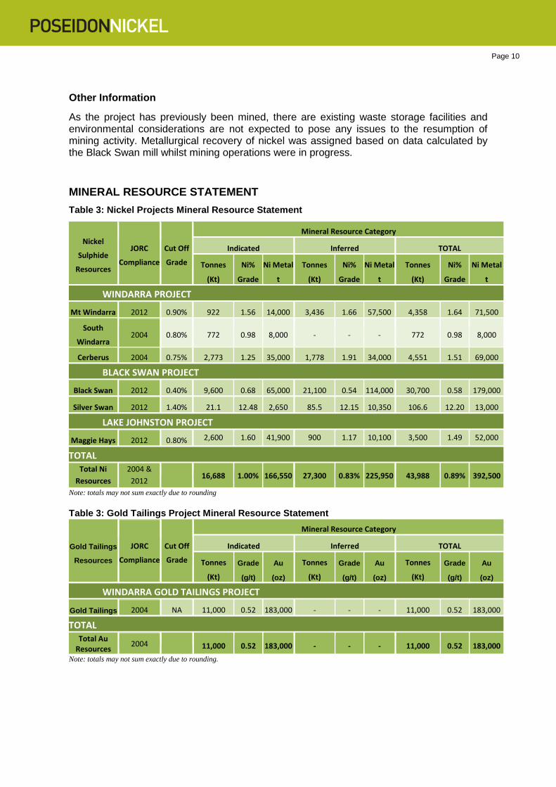
As the project has previously been mined, there are existing waste storage facilities and environmental considerations are not expected to pose any issues to the resumption of mining activity. Metallurgical recovery of nickel was assigned based on data calculated by the Black Swan mill whilst mining operations were in progress. MINERAL RESOURCE STATEMENT Table 3: Nickel Projects Mineral Resource Statement
Nickel
Sulphide
Resources JORC
Compliance
Cut Off
Grade
Mineral Resource Category Indicated Inferred TOTAL
Tonnes
(Kt) Ni%
Grade Ni Metal
t Tonnes
(Kt) Ni%
Grade Ni Metal
t Tonnes
(Kt) Ni%
Grade Ni Metal
t WINDARRA PROJECT
Mt Windarra 2012 0.90% 922 1.56 14,000 3,436 1.66 57,500 4,358 1.64 71,500
South
Windarra 2004 0.80% 772 0.98 8,000 - - - 772 0.98 8,000 Cerberus 2004 0.75% 2,773 1.25 35,000 1,778 1.91 34,000 4,551 1.51 69,000
BLACK SWAN PROJECT
Black Swan 2012 0.40% 9,600 0.68 65,000 21,100 0.54 114,000 30,700 0.58 179,000 Silver Swan 2012 1.40% 21.1 12.48 2,650 85.5 12.15 10,350 106.6 12.20 13,000
LAKE JOHNSTON PROJECT
Maggie Hays 2012 0.80% 2,600 1.60 41,900 900 1.17 10,100 3,500 1.49 52,000
TOTAL
Total Ni Resources
2004 & 2012 16,688 1.00% 166,550 27,300 0.83% 225,950 43,988 0.89% 392,500
Note: totals may not sum exactly due to rounding Table 3: Gold Tailings Project Mineral Resource Statement
Gold Tailings
Resources JORC
Compliance
Cut Off
Grade
Mineral Resource Category Indicated Inferred TOTAL
Tonnes
(Kt) Grade
(g/t) Au
(oz) Tonnes
(Kt) Grade
(g/t) Au
(oz) Tonnes
(Kt) Grade
(g/t) Au
(oz) WINDARRA GOLD TAILINGS PROJECT
Gold Tailings 2004 NA 11,000 0.52 183,000 - - - 11,000 0.52 183,000
TOTAL
Total Au Resources 2004
11,000 0.52 183,000 - - - 11,000 0.52 183,000
Note: totals may not sum exactly due to rounding.
Page 11
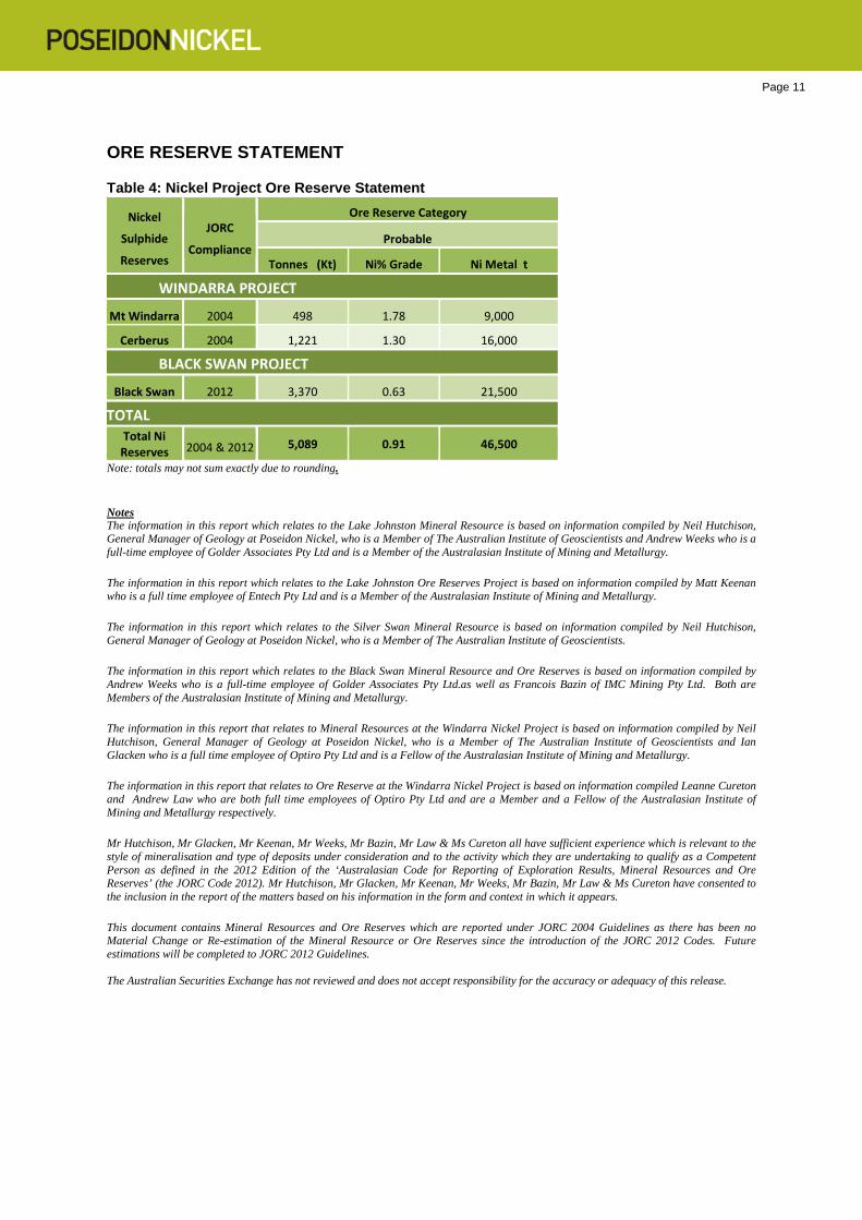
ORE RESERVE STATEMENT
Table 4: Nickel Project Ore Reserve Statement
Nickel
Sulphide
Reserves JORC
Compliance
Ore Reserve Category Probable
Tonnes (Kt) Ni% Grade Ni Metal t WINDARRA PROJECT
Mt Windarra 2004 498 1.78 9,000
Cerberus 2004 1,221 1.30 16,000 BLACK SWAN PROJECT
Black Swan 2012 3,370 0.63 21,500 TOTAL
Total Ni Reserves 2004 & 2012 5,089 0.91 46,500
Note: totals may not sum exactly due to rounding.
Notes The information in this report which relates to the Lake Johnston Mineral Resource is based on information compiled by Neil Hutchison, General Manager of Geology at Poseidon Nickel, who is a Member of The Australian Institute of Geoscientists and Andrew Weeks who is a full-time employee of Golder Associates Pty Ltd and is a Member of the Australasian Institute of Mining and Metallurgy.
The information in this report which relates to the Lake Johnston Ore Reserves Project is based on information compiled by Matt Keenan who is a full time employee of Entech Pty Ltd and is a Member of the Australasian Institute of Mining and Metallurgy.
The information in this report which relates to the Silver Swan Mineral Resource is based on information compiled by Neil Hutchison, General Manager of Geology at Poseidon Nickel, who is a Member of The Australian Institute of Geoscientists.
The information in this report which relates to the Black Swan Mineral Resource and Ore Reserves is based on information compiled by Andrew Weeks who is a full-time employee of Golder Associates Pty Ltd.as well as Francois Bazin of IMC Mining Pty Ltd. Both are Members of the Australasian Institute of Mining and Metallurgy.
The information in this report that relates to Mineral Resources at the Windarra Nickel Project is based on information compiled by Neil Hutchison, General Manager of Geology at Poseidon Nickel, who is a Member of The Australian Institute of Geoscientists and Ian Glacken who is a full time employee of Optiro Pty Ltd and is a Fellow of the Australasian Institute of Mining and Metallurgy.
The information in this report that relates to Ore Reserve at the Windarra Nickel Project is based on information compiled Leanne Cureton and Andrew Law who are both full time employees of Optiro Pty Ltd and are a Member and a Fellow of the Australasian Institute of Mining and Metallurgy respectively.
Mr Hutchison, Mr Glacken, Mr Keenan, Mr Weeks, Mr Bazin, Mr Law & Ms Cureton all have sufficient experience which is relevant to the style of mineralisation and type of deposits under consideration and to the activity which they are undertaking to qualify as a Competent Person as defined in the 2012 Edition of the ‘Australasian Code for Reporting of Exploration Results, Mineral Resources and Ore Reserves’ (the JORC Code 2012). Mr Hutchison, Mr Glacken, Mr Keenan, Mr Weeks, Mr Bazin, Mr Law & Ms Cureton have consented to the inclusion in the report of the matters based on his information in the form and context in which it appears.
This document contains Mineral Resources and Ore Reserves which are reported under JORC 2004 Guidelines as there has been no Material Change or Re-estimation of the Mineral Resource or Ore Reserves since the introduction of the JORC 2012 Codes. Future estimations will be completed to JORC 2012 Guidelines. The Australian Securities Exchange has not reviewed and does not accept responsibility for the accuracy or adequacy of this release.
Page 12 CORPORATE DIRECTORY Principal Office Unit 8, Churchill Court Director / Senior Management 331-335 Hay Street David Singleton Managing Director & Chief Executive Officer SUBIACO WA 6008 Chris Indermaur Non-Executive Chairman P: 61 8 6167 6600 Geoff Brayshaw Non-Executive Director F: 61 8 6167 6649 Robert Dennis Non-Executive Director Ross Kestel Company Secretary Registered Office Level 2, Spectrum 100 Railway Road Corporate Enquiries SUBIACO WA 6008 Mr David Singleton – MD & CEO P: 61 8 9367 8133 P: 61 8 6167 6600 F: 61 8 9367 8812 F: 61 8 6167 6649 Media Enquiries E: [email protected] P: 61 8 6167 6600 F: 61 8 6167 6649 Shareholder Enquiries E: [email protected] Enquiries concerning shareholdings should be addressed to: Home Exchange Computershare Investor Services The Company’s shares are listed GPO Box D182, Perth WA 6840 on the Australian Securities Exchange P: 61 8 9323 2000 and the home exchange is Perth ASX code: POS
Page 13
ATTACHMENT A JORC (2012) Table 1 Silver Swan
Page 14
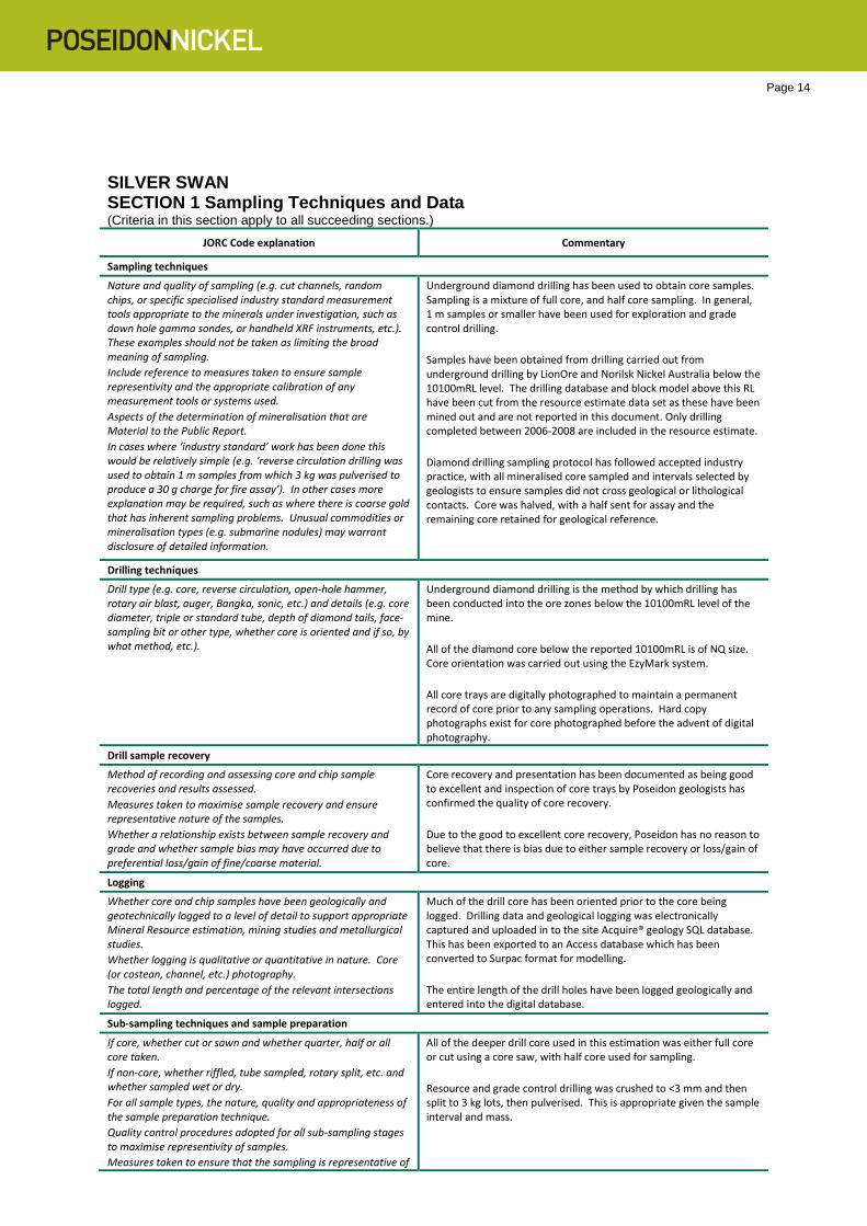
SILVER SWAN SECTION 1 Sampling Techniques and Data (Criteria in this section apply to all succeeding sections.)
JORC Code explanation Commentary
Sampling techniques
Nature and quality of sampling (e.g. cut channels, random chips, or specific specialised industry standard measurement tools appropriate to the minerals under investigation, such as down hole gamma sondes, or handheld XRF instruments, etc.). These examples should not be taken as limiting the broad meaning of sampling. Include reference to measures taken to ensure sample representivity and the appropriate calibration of any measurement tools or systems used. Aspects of the determination of mineralisation that are Material to the Public Report. In cases where ‘industry standard’ work has been done this would be relatively simple (e.g. ‘reverse circulation drilling was used to obtain 1 m samples from which 3 kg was pulverised to produce a 30 g charge for fire assay’). In other cases more explanation may be required, such as where there is coarse gold that has inherent sampling problems. Unusual commodities or mineralisation types (e.g. submarine nodules) may warrant disclosure of detailed information.
Underground diamond drilling has been used to obtain core samples. Sampling is a mixture of full core, and half core sampling. In general, 1 m samples or smaller have been used for exploration and grade control drilling. Samples have been obtained from drilling carried out from underground drilling by LionOre and Norilsk Nickel Australia below the 10100mRL level. The drilling database and block model above this RL have been cut from the resource estimate data set as these have been mined out and are not reported in this document. Only drilling completed between 2006-2008 are included in the resource estimate. Diamond drilling sampling protocol has followed accepted industry practice, with all mineralised core sampled and intervals selected by geologists to ensure samples did not cross geological or lithological contacts. Core was halved, with a half sent for assay and the remaining core retained for geological reference.
Drilling techniques
Drill type (e.g. core, reverse circulation, open-hole hammer, rotary air blast, auger, Bangka, sonic, etc.) and details (e.g. core diameter, triple or standard tube, depth of diamond tails, face-sampling bit or other type, whether core is oriented and if so, by what method, etc.).
Underground diamond drilling is the method by which drilling has been conducted into the ore zones below the 10100mRL level of the mine. All of the diamond core below the reported 10100mRL is of NQ size. Core orientation was carried out using the EzyMark system. All core trays are digitally photographed to maintain a permanent record of core prior to any sampling operations. Hard copy photographs exist for core photographed before the advent of digital photography.
Drill sample recovery
Method of recording and assessing core and chip sample recoveries and results assessed. Measures taken to maximise sample recovery and ensure representative nature of the samples. Whether a relationship exists between sample recovery and grade and whether sample bias may have occurred due to preferential loss/gain of fine/coarse material.
Core recovery and presentation has been documented as being good to excellent and inspection of core trays by Poseidon geologists has confirmed the quality of core recovery. Due to the good to excellent core recovery, Poseidon has no reason to believe that there is bias due to either sample recovery or loss/gain of core.
Logging
Whether core and chip samples have been geologically and geotechnically logged to a level of detail to support appropriate Mineral Resource estimation, mining studies and metallurgical studies. Whether logging is qualitative or quantitative in nature. Core (or costean, channel, etc.) photography. The total length and percentage of the relevant intersections logged.
Much of the drill core has been oriented prior to the core being logged. Drilling data and geological logging was electronically captured and uploaded in to the site Acquire® geology SQL database. This has been exported to an Access database which has been converted to Surpac format for modelling. The entire length of the drill holes have been logged geologically and entered into the digital database.
Sub-sampling techniques and sample preparation
If core, whether cut or sawn and whether quarter, half or all core taken. If non-core, whether riffled, tube sampled, rotary split, etc. and whether sampled wet or dry. For all sample types, the nature, quality and appropriateness of the sample preparation technique. Quality control procedures adopted for all sub-sampling stages to maximise representivity of samples. Measures taken to ensure that the sampling is representative of
All of the deeper drill core used in this estimation was either full core or cut using a core saw, with half core used for sampling. Resource and grade control drilling was crushed to <3 mm and then split to 3 kg lots, then pulverised. This is appropriate given the sample interval and mass.
Page 15
JORC Code explanation Commentary
the in situ material collected, including for instance results for field duplicate/second-half sampling. Whether sample sizes are appropriate to the grain size of the material being sampled.
Quality of assay data and laboratory tests
The nature, quality and appropriateness of the assaying and laboratory procedures used and whether the technique is considered partial or total. For geophysical tools, spectrometers, handheld XRF instruments, etc., the parameters used in determining the analysis including instrument make and model, reading times, calibrations factors applied and their derivation, etc. Nature of quality control procedures adopted (e.g. standards, blanks, duplicates, external laboratory checks) and whether acceptable levels of accuracy (i.e. lack of bias) and precision have been established.
All assaying since March 2004 has been carried out by Kalgoorlie Assay Laboratories (Kalassay) using ICP-OES on a 4 acid digest using standard laboratory practices. Both independent and laboratory internal QAQC were used. Site specific standards were derived from two RC drill holes specifically designed for the purpose and prepared by ORE Pty Ltd in Melbourne. Analysis for these standards was for Ni, As, Fe and Mg. The following QA/QC measures were adopted during the sampling and assaying of underground diamond drill core and include:
• Blank’ inserted in 1:25 samples • Certified standards inserted in 1:25 samples • Sizing analysis of 1:20 samples • Duplicate analysis of quarter core for 1:25 holes • Analysis of laboratory QAQC. Repeat analysis completed by
laboratory on 5% of samples • Monthly reporting of QAQC • Six monthly temporal and spatial analysis of the erroneous
standards and blanks. The quality of the data received from the laboratory appears to be good, with no major issues being highlighted. Standard samples have a well-defined margin of error suitable for the deposit. No external laboratory checks were conducted on the drill samples.
Verification of sampling and assaying
The verification of significant intersections by either independent or alternative company personnel. The use of twinned holes. Documentation of primary data, data entry procedures, data verification, data storage (physical and electronic) protocols. Discuss any adjustment to assay data.
Logging and assay data is electronically captured and up loaded in to the site Acquire® geology SQL database which was handed over to Poseidon following the sale transaction. This has been exported to an Access database which has been converted to Surpac format for modelling.
Location of data points
Accuracy and quality of surveys used to locate drill holes (collar and down-hole surveys), trenches, mine workings and other locations used in Mineral Resource estimation. Specification of the grid system used. Quality and adequacy of topographic control.
All collar surveys were completed to an accuracy of ±10 mm and recorded by the underground surveyor. A local grid based on seven known AMG_84 references was created. The Department of Land Information (formerly the Department of Land Administration) benchmark UO51 on the Yarri Road opposite 14 Mile Dam was used to tie the survey control stations to the Australian Height Datum (AHD). A height datum of AHD + 1000 m was adopted for the Black Swan project. A local mine grid was established and used throughout the operation. Poseidon has also converted surveys to the current MGA_94 grid format. All Silver Swan diamond drill holes have been routinely surveyed downhole. All underground diamond drill holes have been surveyed using either Eastman Single Shot down hole survey instruments or Reflex Gyro instruments.
Data spacing and distribution
Data spacing for reporting of Exploration Results. Whether the data spacing and distribution is sufficient to establish the degree of geological and grade continuity appropriate for the Mineral Resource and Ore Reserve estimation procedure(s) and classifications applied. Whether sample compositing has been applied.
Underground drilling used a maximum spacing of 10 m x 10 m for Indicated category resources and approximately 10m x 20m and 20 m x 40m for Inferred resources. Sample data was composited to 1 m.
Page 16
JORC Code explanation Commentary
Orientation of data in relation to geological structure
Whether the orientation of sampling achieves unbiased sampling of possible structures and the extent to which this is known, considering the deposit type. If the relationship between the drilling orientation and the orientation of key mineralised structures is considered to have introduced a sampling bias, this should be assessed and reported if material.
Drill hole orientation was dominantly between 200-60o to geological continuity as the mineralisation is drilled form underground workings in the footwall of the deposit which dips 800 to grid east. The angle of intersection is factored into the resource shape interpretations and is well understood as it is verified by mining and reconciliation of the ore zones to a depth of 1300m below surface. The sampling and interpretations meets the requirements of the resource estimation.
Sample security
The measures taken to ensure sample security. There are no documented details available for sample security. As the mine is not precious metals and the drilling consists of visually observable massive nickel sulphide mineralisation, security is not considered to have been compromised.
Audits or reviews
The results of any audits or reviews of sampling techniques and data.
Examination of duplicate, blank and standard data does not highlight any material bias or systematic error. The drill hole intersections correlate well with the block model results.
Section 2 Reporting of Exploration Results (Criteria listed in the preceding section also apply to this section.)
Section 2: Reporting of Exploration Results
Mineral Tenement and Land Tenure Status
Type, reference name/number, location and ownership including agreements or material issues with third parties such as joint ventures, partnerships, overriding royalties, native title interests, historical sites, wilderness or national park and environmental settings. The security of the tenure held at the time of reporting along with any known impediments to obtaining a licence to operate in the area.
Silver Swan underground mine is located in the Kalgoorlie District within M27/200. Silver Swan mine is part of the Black Swan Operation which is located 42.5km NE of Kalgoorlie. M27/200 is registered to MPI Nickel PTY Ltd which is a 100% subsidiary of OJSC MMC Norilsk Nickel. Following the purchase of the assets from Norilsk, the tenement is currently in the process of being transferred to Poseidon Nickel Limited. All operating licences are in place and are currently being renewed and transferred to Poseidon Nickel. Historical royalties of 3% NSR exist over the minerals produced.
Exploration Done by Other Parties
Acknowledgment and appraisal of exploration by other parties. The Silver Swan Mine was discovered by MPI Mines Ltd, then was acquired by LionOre in 2004. Much of the exploration drilling and development was completed by these 2 companies. In turn LionOre was taken over by Norilsk in 2007 and continued mining and developing the underground mine at Silver Swan. Poseidon Nickel purchased the operation from Norilsk in late 2014.
Geology
Deposit type, geological setting and style of mineralisation. Silver Swan deposit is a Kambalda style komatiite hosted nickel deposit.
Drill Hole Information
No new Exploration Results have been reported.
Data Aggregation Methods
No new Exploration Results have been reported.
Relationship Between Mineralisation Widths and Intercept Lengths
No new Exploration Results have been reported.
Diagrams
No new Exploration Results have been reported.
Balance Reporting
No new Exploration Results have been reported.
Other Substantive Exploration Data
No new Exploration Results have been reported.
Further work
Poseidon expects to undertake further resource definition and grade control drilling at Silver Swan to convert Inferred resources to Indicated resources.
Page 17 Section 3 Estimation and Reporting of Mineral Resources (Criteria listed in section 1, and where relevant in section 2, also apply to this section.)
JORC Code explanation Commentary
Database integrity
Measures taken to ensure that data has not been corrupted by, for example, transcription or keying errors, between its initial collection and its use for Mineral Resource estimation purposes. Data validation procedures used.
Logging and assay data has been electronically captured and uploaded in to the site Acquire® geology SQL database. The database has been previously reviewed by Golder Associates and was found to be in excellent condition. It is very clean and contains few errors, but does not contain sample and assay quality control information. Both Golder & Poseidon have conducted visual validation checks on the drill hole data, with holes not relevant to the estimation (above the 10100mRL) removed from the dataset.
Site visits
Comment on any site visits undertaken by the Competent Person and the outcome of those visits. If no site visits have been undertaken indicate why this is the case.
Mr Neil Hutchison the General Manger-Geology and Competent Person for Poseidon has visited the Black Swan site and Silver Swan underground mine on numerous occasions within the last 18 months. Underground inspections of access and ore development drives relevant to this resource estimate have been verified by Mr Hutchison on several visits. Black Swan has a long history of exploration and has been an operating mine, with both open pit and underground mining operations taking place.
Geological interpretation
Confidence in (or conversely, the uncertainty of ) the geological interpretation of the mineral deposit. Nature of the data used and of any assumptions made. The effect, if any, of alternative interpretations on Mineral Resource estimation. The use of geology in guiding and controlling Mineral Resource estimation. The factors affecting continuity both of grade and geology.
The geological interpretation is validated by drill and mining activity, as well as face mapping by the previous owners. Estimation has been restricted to lithologies controlling and surrounding mineralisation. The geological domaining is based on data from previous resource estimates completed by Norilsk Nickel Pty Ltd and have been reviewed by Golder Associates previously. The interpretation for this Mineral Resource estimate relies solely upon data from drilling below the 10100mRL, and not on mapping or face sampling.
Dimensions
The extent and variability of the Mineral Resource expressed as length (along strike or otherwise), plan width, and depth below surface to the upper and lower limits of the Mineral Resource.
The mineralisation associated with the Silver Swan mine has a width of approximately 375 m striking grid north-south and has been defined to a down dip length of 1550m plunging towards the east. Individual sulphide lenses are typically 3-5m in thickness. Drilling has intercepted Ni mineralisation down to a depth of 1600 m below surface and is still open down plunge.
Estimation and modelling techniques
The nature and appropriateness of the estimation technique(s) applied and key assumptions, including treatment of extreme grade values, domaining, interpolation parameters and maximum distance of extrapolation from data points. If a computer assisted estimation method was chosen include a description of computer software and parameters used. The availability of check estimates, previous estimates and/or mine production records and whether the Mineral Resource estimate takes appropriate account of such data. The assumptions made regarding recovery of by-products. Estimation of deleterious elements or other non-grade variables of economic significance (e.g. sulphur for acid mine drainage characterisation). In the case of block model interpolation, the block size in relation to the average sample spacing and the search employed. Any assumptions behind modelling of selective mining units. Any assumptions about correlation between variables. Description of how the geological interpretation was used to control the resource estimates. Discussion of basis for using or not using grade cutting or capping. The process of validation, the checking process used, the comparison of model data to drill hole data, and use of reconciliation data if available.
Mineralisation was estimated within domains defined by lithological information and statistical analysis of sample data in the composite file was used for estimation purposes. The block size is 2 m (X) by 5 m (Y) by 10 m (Z). The variable sub-block size is 0.25 m (X) by 1.25 m (Y) by 2.5 m (Z). This degree of sub-blocking is used because of the narrow and variable shoot geometry. Block discretisation points used were X:1, Y:2, Z:5. Prior to estimation block models are coded using domain wireframes (ore and waste domains). Dykes, mined out volumes, and resource categories were all coded into the block model after estimation was completed. Two estimation passes were used for massive sulphide domains and search parameters were selected to more closely honour each attributes variogram, with the exception of ‘true thickness’. Thickness values were estimated for each parameter (Ni x TW, As x TW, SG x TW) using the variogram model for that parameter. The orientations of search ellipses were set to mirror the orientation of each orebody. Using parameters derived from the modelled variograms, Ordinary Kriging (OK) was used to estimate average block grades for Ni, As, and SG. The minimum number of samples required for the first estimation pass was set at 5. The minimum number of samples required for the second estimation pass was set at 1 to ensure that all blocks within each domain were estimated. The maximum number of samples for both estimation passes was set at 25. This was based on a visual estimate of the maximum number of samples that the search
Page 18
JORC Code explanation Commentary
ellipse would include in the more informed portions of the domains. Search parameters for the waste domains were selected using the variogram model for that parameter. One estimation pass was used for waste domains. The minimum number of samples required to estimate a block was set at 6 and the maximum number of samples was set at 20.
Moisture
Whether the tonnages are estimated on a dry basis or with natural moisture, and the method of determination of the moisture content.
Density measurements were performed using the immersion technique. The density was calculated as a wet density. The core from underground is fresh, dense and non-porous therefore moisture content is not considered to be an issue.
Cut-off parameters
The basis of the adopted cut-off grade(s) or quality parameters applied.
The resource model is constrained by assumptions about economic cut-off grades. The Mineral Resource was modelled using a 0.4% wireframe cut-off grade and reported using a cut-off grade of 1.4% Ni which was applied on a block by block basis.
Mining factors or assumptions
Assumptions made regarding possible mining methods, minimum mining dimensions and internal (or, if applicable, external) mining dilution. It is always necessary as part of the process of determining reasonable prospects for eventual economic extraction to consider potential mining methods, but the assumptions made regarding mining methods and parameters when estimating Mineral Resources may not always be rigorous. Where this is the case, this should be reported with an explanation of the basis of the mining assumptions made.
The following assumptions have been factored regarding possible mining methods;
• A mining dilution of 25% has been applied to stopes. • 50% dilution has been applied to the 3.5m x 3.5m development ore
drives. • Single boom jumbos are used for development ore drives. • Airleg flatback mining using 2m x 2.5m ore stoping is applied. • A mining recovery of 91% ore extraction has been used due to pillars. • Stopes are backfilled with development waste.
Metallurgical factors or assumptions
The basis for assumptions or predictions regarding metallurgical amenability. It is always necessary as part of the process of determining reasonable prospects for eventual economic extraction to consider potential metallurgical methods, but the assumptions regarding metallurgical treatment processes and parameters made when reporting Mineral Resources may not always be rigorous. Where this is the case, this should be reported with an explanation of the basis of the metallurgical assumptions made.
Metallurgical recovery of nickel was assigned based on data calculated by the Black Swan mill whilst mining operations were in progress.
Environmental factors or assumptions
Assumptions made regarding possible waste and process residue disposal options. It is always necessary as part of the process of determining reasonable prospects for eventual economic extraction to consider the potential environmental impacts of the mining and processing operation. While at this stage the determination of potential environmental impacts, particularly for a greenfields project, may not always be well advanced, the status of early consideration of these potential environmental impacts should be reported. Where these aspects have not been considered this should be reported with an explanation of the environmental assumptions made.
As the project has previously been mined, there are existing waste storage facilities and environmental considerations are not expected to pose any issues to the resumption of mining activity.
Bulk density
Whether assumed or determined. If assumed, the basis for the assumptions. If determined, the method used, whether wet or dry, the frequency of the measurements, the nature, size and representativeness of the samples. The bulk density for bulk material must have been measured by methods that adequately account for void spaces (vugs, porosity, etc.), moisture and differences between rock and alteration zones within the deposit. Discuss assumptions for bulk density estimates used in the evaluation process of the different materials.
Bulk density measurements were routinely collected for all underground drill core submitted for analysis. The majority of measurements have been made using the water immersion method where the weight of selected pieces of core is measured in both air and water. All weights were measured using an electronic balance. The bulk density measurements are treated in a similar way to assay results and are used to interpolate bulk density values into the various orebody block models during the grade interpolation phase. As such there was a close control on the short scale variability of bulk density and hence tonnage.
Classification
The basis for the classification of the Mineral Resources into Resources were classified in accordance with the Australasian Code for the
Page 19
JORC Code explanation Commentary
varying confidence categories. Whether appropriate account has been taken of all relevant factors (i.e. relative confidence in tonnage/grade estimations, reliability of input data, confidence in continuity of geology and metal values, quality, quantity and distribution of the data). Whether the result appropriately reflects the Competent Person’s view of the deposit.
Reporting of Exploration Results, Mineral Resources and Ore Reserves (JORC Code, 2012 Edition). The classification of Mineral Resources was completed by Poseidon based on geological confidence, drill hole spacing, data density and grade continuity. The Competent Person is satisfied that the result appropriately reflects his view of the deposit. Continuous zones meeting the following criteria were used to define the resource class: Measured Resource
• Measured Mineral Resources consist of the high confidence material which has been grade control drilled (10x15m) and sill development has been completed both above and below.
• No material is categorised as Measured in this resource estimation Indicated Resource
• The Indicated Mineral Resources reflects moderate confidence material with good data density.
• Reflects a nominal drill spacing of less than 25m x 25m resource definition drilling, through to grade control drilling (10 x 15m spacing), but no ore drives.
Inferred Resource
• The Inferred Mineral Resource reflects uncertainty in continuity of the massive sulphides confirmed by drill intersection with poor data density.
• Blocks that were estimated with samples with an average of less than 50 m distance from blocks.
• Limited number of drill holes. Audits or reviews
The results of any audits or reviews of Mineral Resource estimates.
This Mineral Resource estimate has been compared with previous non-JORC resource estimates completed by Norilsk Nickel Pty Ltd and which have been reviewed by Golder. This estimate compares favourably with the depleted estimates for the mineralisation below the 10100mRL.
Discussion of relative accuracy/confidence
Where appropriate a statement of the relative accuracy and confidence level in the Mineral Resource estimate using an approach or procedure deemed appropriate by the Competent Person. For example, the application of statistical or geostatistical procedures to quantify the relative accuracy of the resource within stated confidence limits, or, if such an approach is not deemed appropriate, a qualitative discussion of the factors that could affect the relative accuracy and confidence of the estimate. The statement should specify whether it relates to global or local estimates, and, if local, state the relevant tonnages, which should be relevant to technical and economic evaluation. Documentation should include assumptions made and the procedures used. These statements of relative accuracy and confidence of the estimate should be compared with production data, where available.
The relative accuracy is reflected in the resource classification discussed above that is in line with industry acceptable standards. This is a Mineral Resource estimate that includes knowledge gained from mining and milling recovery data during production.