Embed Size (px)
Citation preview
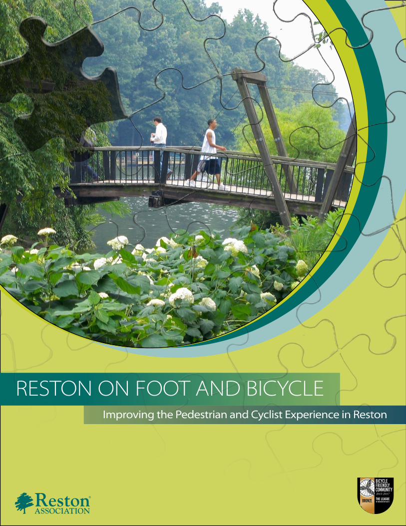
RESTON ON FOOT AND BICYCLEImproving the Pedestrian and Cyclist Experience in Reston
BICYCLEFRIENDLYCOMMUNITY
BRONZE
2013-2017
INTRODUCTION 3
Purpose 3
Benefits 3
What’s New 4
THE PEDESTRIAN AND BICYCLING ADVISORY COMMITTEE 6
RESPONSIBILITIES 6
CHARACTERISTICS OF PEDESTRIAN AND BICYCLE FRIENDLY COMMUNITIES 6
RESPONSIBLE ORGANIZATIONS 7
VDOT TIPS FOR SAFE BICYCLING 8
PEDESTRIAN FACILITIES 9
BICYCLE FACILITIES 11
RECOMMENDATIONS 13
Intersection Improvements 15
Walkway Improvements 21
Bicycle Facility Improvements 26
The Need For An Implementation Mechanism 26
RESOURCES 29
HISTORY OF RESTON ON FOOT AND BICYCLE 30
THE NEED FOR PERIODIC UPDATING 30
Origins 30
1994 Update 31
1999 Update 31
2008 Update 32
TABLE OF CONTENTS

3
INTRODUCTION
PURPOSEWe feel fortunate to live in Reston, a place that was designed to be healthy, family-centered and enjoyable. To a large extent, this vision was to be realized by the creation of an extensive pathway network for recreation and transportation.
Vision is one thing, reality another. Pedestrians increasingly prefer to walk on more traditional sidewalks that take them where they want to go faster and safer, particularly at night. More and more people use bicycles as transportation and need convenient on-street bicycle infrastructure. However, neighborhood shopping areas, the Town Center and places of work are not always easily accessible by foot or bicycle. Even people who live within a reasonable walking or cycling distance from their regular destinations consider driving to be a better transportation option due to missing infrastructure. This adds up to significant barriers to getting around “Reston on Foot and Bicycle.”
The Pedestrian and Bicycling Advisory Committee (PBAC) is committed to making Reston more accessible for walking and bicycling. The Committee studies Reston’s pedestrian and bicycling facilities and needs, develops recommendations and presents them in this report. By identifying responsible parties whenever possible, the Committee hopes this carefully researched plan will be used to make Reston safer, more comfortable and more convenient for walking and cycling.
This report is designed to inform decision-makers in Reston, Fairfax County, and the State of Virginia and may be helpful to people who are interested in improving the bicycling and walking conditions in Reston. Residents and Reston-based employers and employees are encouraged to contact the PBAC to voice their opinions on recommendations stated in this report so that the Committee can better determine and communicate the community’s priorities. The Reston Association (RA) Board of Directors should coordinate implementation of the recommendations with the County and the State. The completion of each project is a step to making the network complete.
BENEFITSRoads and trails that are safe for walking and bicycling are critical for creating healthy, active communities. Consider the benefits of having more people walking and bicycling more often:
· Cleaner environment: Reduced air, soil and water pollution.· Homeland security: Independence from fossil fuels and other finite energy sources. · Health: 30 minutes of daily physical activity increases one’s chance of living a longer life, and reduces the
likelihood of developing chronic diseases such as depression and diabetes.· Independence: Increased mobility options for older adults, people with lower incomes, people with
disabilities, people that choose not to drive, teens and children.· Social: Walking and cycling encourages people to make meaningful social connections and build
relationships within their community.· Economics: A comprehensive network of on- and off-street facilities for walking and cycling increases land
values, contributes to a stronger local economy, and reduces maintenance needs of the road network.· Learning & Productivity: Physically active students and employees perform better. · Safety: Car crashes are the leading cause of death for people ages 2 – 34. Making streets safer for pedestrians
and cyclists makes roads safer for all road users. · Quality of Life: Walking and bicycling reduce traffic congestion and noise pollution.
The economic benefits of bicyclinghttp://www.bikeleague.org/sites/lab.huang.radicaldesigns.org/files/eco-impact-map_0.jpg
Advocacy Advance http://www.advocacyadvance.org/site_images/content/Final_Econ_Update%28small%29.pdf
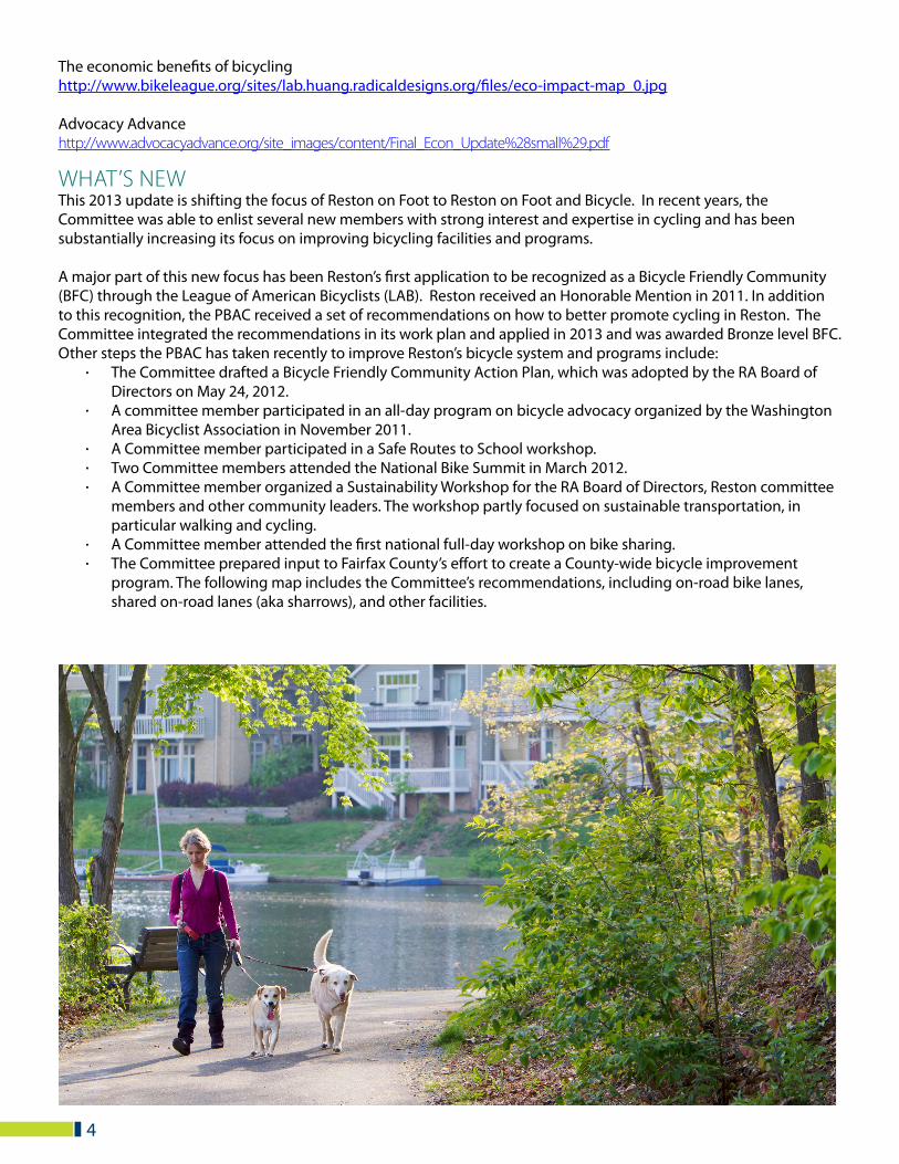
WHAT’S NEWThis 2013 update is shifting the focus of Reston on Foot to Reston on Foot and Bicycle. In recent years, the Committee was able to enlist several new members with strong interest and expertise in cycling and has been substantially increasing its focus on improving bicycling facilities and programs.
A major part of this new focus has been Reston’s first application to be recognized as a Bicycle Friendly Community (BFC) through the League of American Bicyclists (LAB). Reston received an Honorable Mention in 2011. In addition to this recognition, the PBAC received a set of recommendations on how to better promote cycling in Reston. The Committee integrated the recommendations in its work plan and applied in 2013 and was awarded Bronze level BFC.Other steps the PBAC has taken recently to improve Reston’s bicycle system and programs include:
· The Committee drafted a Bicycle Friendly Community Action Plan, which was adopted by the RA Board of Directors on May 24, 2012.
· A committee member participated in an all-day program on bicycle advocacy organized by the Washington Area Bicyclist Association in November 2011.
· A Committee member participated in a Safe Routes to School workshop.· Two Committee members attended the National Bike Summit in March 2012.· A Committee member organized a Sustainability Workshop for the RA Board of Directors, Reston committee
members and other community leaders. The workshop partly focused on sustainable transportation, in particular walking and cycling.
· A Committee member attended the first national full-day workshop on bike sharing.· The Committee prepared input to Fairfax County’s effort to create a County-wide bicycle improvement
program. The following map includes the Committee’s recommendations, including on-road bike lanes, shared on-road lanes (aka sharrows), and other facilities.
4
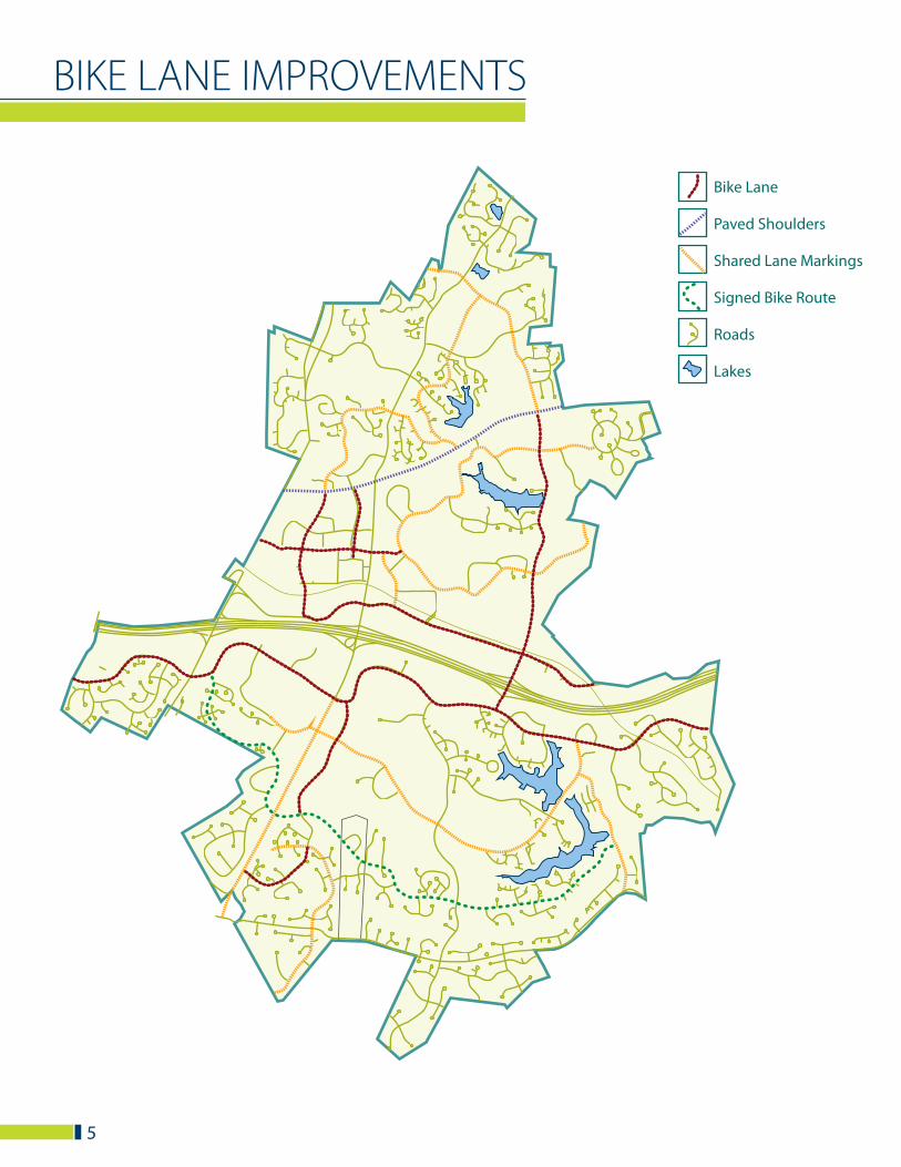
BIKE LANE IMPROVEMENTS
5
Bike Lane
Paved Shoulders
Shared Lane Markings
Signed Bike Route
Roads
Lakes
6
The Pedestrian and Bicycling Advisory Committee advises the Board of Directors on the sound development, management, and safe use of Reston’s pedestrian and bicycle systems as they relate to infrastructure improvements, accessibility, and promoting the benefits of these systems.
RESPONSIBILITIES· In coordination with private and public entities, governmental agencies, and citizens, evaluate and provide
recommendations regarding necessary improvements to, changes to, or funding for Reston’s pedestrian and bicycle systems/facilities.
· Assist in developing priorities for funding improvements of such systems.· Encourage utilization of pedestrian and bicycle systems for transportation and recreation.· Evaluate safety concerns and develop recommendations for implementation and public education.
The Committee meets on every second Wednesday of the month at 7 p.m. at the Reston Association offices 12001 Sunrise Valley Drive. The meetings are open to the public.
PBAC MEMBERS AS OF SEPTEMBER 2013:Burton Griffith, ChairBJ Silvey, Member Brian Murphy, Reston Association Staff LiaisonDoug Pew, MemberNicole Wynands, MemberJoe Stowers, MemberCraig Clark, MemberDan Kole, MemberKelley Westenhoff, MemberTimothy Cohn, RA Board
CHARACTERISTICS OF PEDESTRIAN AND BICYCLE FRIENDLY COMMUNITIES
· Focus on moving people, not cars.· Well-maintained and contiguous network of complete and inclusive streets - sidewalks along all streets, traditional
and buffered bike lanes, cycle tracks, sharrows and shared-use paths.· Security and visibility - particularly at crossings, intersections and transit stops - through striped crosswalks, curb
extensions, landscaped refuge islands and bike boxes.· Links to a variety of destinations, amenities and services with highly visible way finding signage.· Ample and high quality bicycle parking at all destinations.· Attractive streetscaping – pedestrian scale lighting, benches, public art, shade, landscaping.· Proximity - Mixed and dense land use patterns throughout the community, including residential areas.· Multimodal - Integration of different modes of transport and of transportation and land use.· Universal design - Accessibility by users of all ages and abilities.· Community-wide traffic calming and traffic reduction - low speeds throughout the community, vehicle-restricted
zones, play streets/shared space, speed tables and bike boulevards.· Disincentives to driving - priced public parking, no minimum parking standards, maximum car parking standards
and shared-parking allowances.· Education - Opportunities for all residents to receive bicycle safety education starting with children in school.
THE PEDESTRIAN AND BICYCLING ADVISORY COMMITTEE
OTHER REGULAR PARTICIPANTS:Bruce Wright, Chairman of Fairfax Advocates for Better Bicycling (FABB)Steve Gurney, Resident
RESPONSIBLE ORGANIZATIONSThis report is intended to facilitate coordination among organizations that will oversee the implementation of PBAC’s recommendations.
The Virginia Department of Transportation (VDOT) is responsible for all intersection and road improvements, including the addition of bike lanes and shared use lanes (or shared lane markings/sharrows), and all appropriate signing and pavement markings for them in Reston and other parts of Fairfax County (except in incorporated towns). These include:
· New traffic signals in some locations in planned development areas of the Town Center, the Metrorail station areas, and other high density areas of Reston.
· New pedestrian signals at many signalized intersections.· Prominently marked crosswalks at many high traffic intersections and path crossings.· New standard crosswalks at many intersections and path crossings on low traffic streets.· “Road diets” of many arterials and collector streets to slow traffic and create space for bicycle infrastructure.· Lower speed limits that currently exceed 35 miles per hour on some arterials.· Lower speed limits that currently exceed 30 miles per hour on some collector streets.
Fairfax County is responsible for approximately 40,000 feet of sidewalks and trails at 41 locations in the Reston area. These are necessary for safe access to schools, jobs, shops, the future Metrorail stations, parks, and county facilities. Missing gaps in the system should be built to design standards and layouts recommended in this plan to maintain consistency with sidewalks and trails, or conform to general community standards.
The Reston Association (RA) is responsible for improvements of facilities such as sidewalks and shared use paths on RA property and improvements that provide important links to RA facilities.
Developers are generally responsible for all pedestrian and bicycle facility improvements on their property; for crosswalks at intersections adjoining their property; for curb cuts at each end of a crosswalk; and wherever an increase in traffic (pedestrian and vehicular) due to the development is generating the need for a signal or facility. The exact responsibilities of a developer are determined on a case by case basis by the county, the Reston Planning and Zoning Committee, and the Reston Association.
Reston residents can help make this community better for people on foot and bicycle by· Not using a cell phone or texting while driving. Studies have shown that driver distraction caused by cell
phones and other hand held devices is as dangerous as driving while intoxicated. · Slowing down. Speeding is a contributing factor in 31 percent of all fatal crashes. · Expecting the unexpected. Pedestrians may be encountered in unexpected places – especially in areas
where the pathway network is incomplete. · Sharing the road. Cyclists should be expected on all roads in Reston. Motorists should use caution when
passing a cyclist and when turning.· Avoiding backing out of a parking space. AAA studies have shown that reversing out of a parking spot is
very dangerous for small children and cyclists. Backing into a parking space is preferable.
7
8
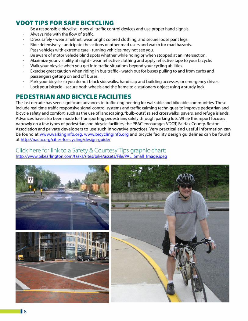
VDOT TIPS FOR SAFE BICYCLING· Be a responsible bicyclist - obey all traffic control devices and use proper hand signals.· Always ride with the flow of traffic.· Dress safely - wear a helmet, wear bright colored clothing, and secure loose pant legs.· Ride defensively - anticipate the actions of other road users and watch for road hazards.· Pass vehicles with extreme care - turning vehicles may not see you.· Be aware of motor vehicle blind spots whether while riding or when stopped at an intersection.· Maximize your visibility at night - wear reflective clothing and apply reflective tape to your bicycle.· Walk your bicycle when you get into traffic situations beyond your cycling abilities.· Exercise great caution when riding in bus traffic - watch out for buses pulling to and from curbs and
passengers getting on and off buses.· Park your bicycle so you do not block sidewalks, handicap and building accesses, or emergency drives.· Lock your bicycle - secure both wheels and the frame to a stationary object using a sturdy lock.
PEDESTRIAN AND BICYCLE FACILITIES The last decade has seen significant advances in traffic engineering for walkable and bikeable communities. These include real time traffic responsive signal control systems and traffic calming techniques to improve pedestrian and bicycle safety and comfort, such as the use of landscaping, “bulb-outs”, raised crosswalks, pavers, and refuge islands. Advances have also been made for transporting pedestrians safely through parking lots. While this report focuses narrowly on a few types of pedestrian and bicycle facilities, the PBAC encourages VDOT, Fairfax County, Reston Association and private developers to use such innovative practices. Very practical and useful information can be found at www.walkinginfo.org, www.bicyclinginfo.org and bicycle facility design guidelines can be found at http://nacto.org/cities-for-cycling/design-guide/
Click here for link to a Safety & Courtesy Tips graphic chart:http://www.bikearlington.com/tasks/sites/bike/assets/File/PAL_Small_Image.jpeg
SIDEWALKS AND TRAILS· Wherever possible, there should be sidewalks on both sides of major thoroughfares.· Sidewalks and major paths should be at least 6 feet wide wherever possible and at least 8 feet on major
pedestrian pathways including sidewalks adjacent to commercial frontage zones (5 foot minimum clear width). Wider paths are necessary where bicyclists are expected to share the trail. These recommendations are minimums, and wider facilities should be considered wherever warranted by volumes.
· Sidewalks should be separated from the roadway by a landscaped buffer of at least four feet wherever possible.· All pedestrian pathways should have adequate, continuous lighting. Wherever high levels of pedestrians are
expected, pedestrian-scale lighting elements should be included that provide good visibility for pedestrians.· Sidewalks and trails should connect to adjacent communities wherever possible to provide additional
connectivity throughout the region, not just within Reston.
In order to promote the use of sidewalks and trails in the Reston of 2030, the study team has developed a set of recommendations that are “urban” in their character. Pedestrians and bicyclists do not need to be separated from the activities of daily life; trails and sidewalks should be built on street level with access to the businesses, residences and other elements of the Reston community.
These more urban roadway cross sections provide a safe and vibrant atmosphere for pedestrians and bicyclists, and encourage these users to use the facilities on a regular basis.
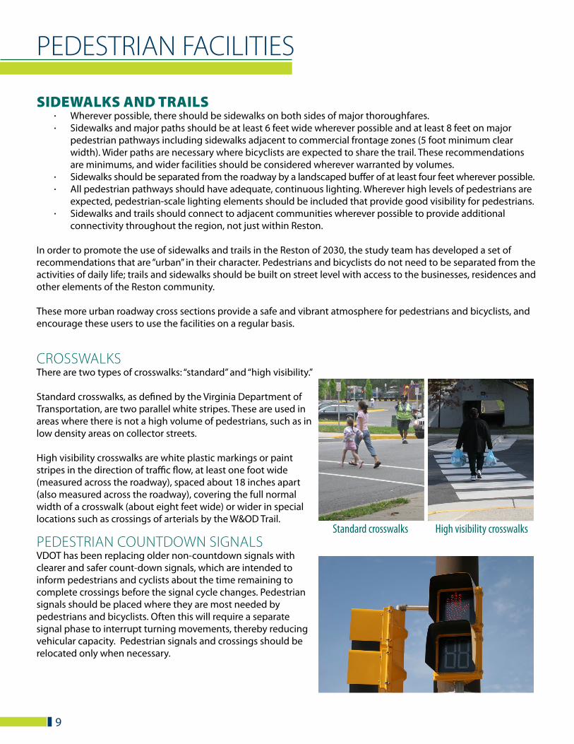
CROSSWALKSThere are two types of crosswalks: “standard” and “high visibility.”
Standard crosswalks, as defined by the Virginia Department of Transportation, are two parallel white stripes. These are used in areas where there is not a high volume of pedestrians, such as in low density areas on collector streets.
High visibility crosswalks are white plastic markings or paint stripes in the direction of traffic flow, at least one foot wide (measured across the roadway), spaced about 18 inches apart (also measured across the roadway), covering the full normal width of a crosswalk (about eight feet wide) or wider in special locations such as crossings of arterials by the W&OD Trail.
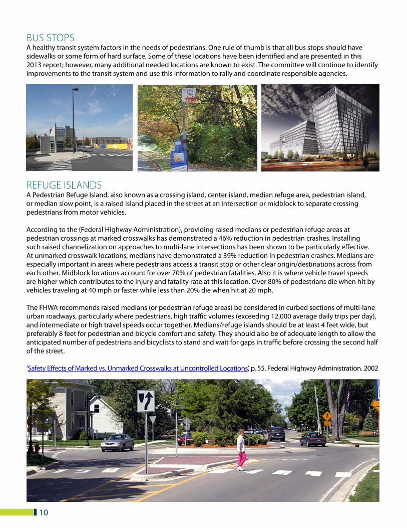
PEDESTRIAN COUNTDOWN SIGNALSVDOT has been replacing older non-countdown signals with clearer and safer count-down signals, which are intended to inform pedestrians and cyclists about the time remaining to complete crossings before the signal cycle changes. Pedestrian signals should be placed where they are most needed by pedestrians and bicyclists. Often this will require a separate signal phase to interrupt turning movements, thereby reducing vehicular capacity. Pedestrian signals and crossings should be relocated only when necessary.
PEDESTRIAN FACILITIES
Standard crosswalks High visibility crosswalks
9
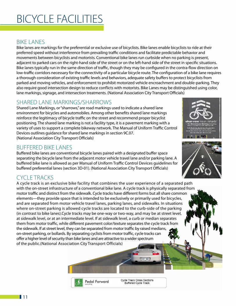
BUS STOPSA healthy transit system factors in the needs of pedestrians. One rule of thumb is that all bus stops should have sidewalks or some form of hard surface. Some of these locations have been identified and are presented in this 2013 report; however, many additional needed locations are known to exist. The committee will continue to identify improvements to the transit system and use this information to rally and coordinate responsible agencies.
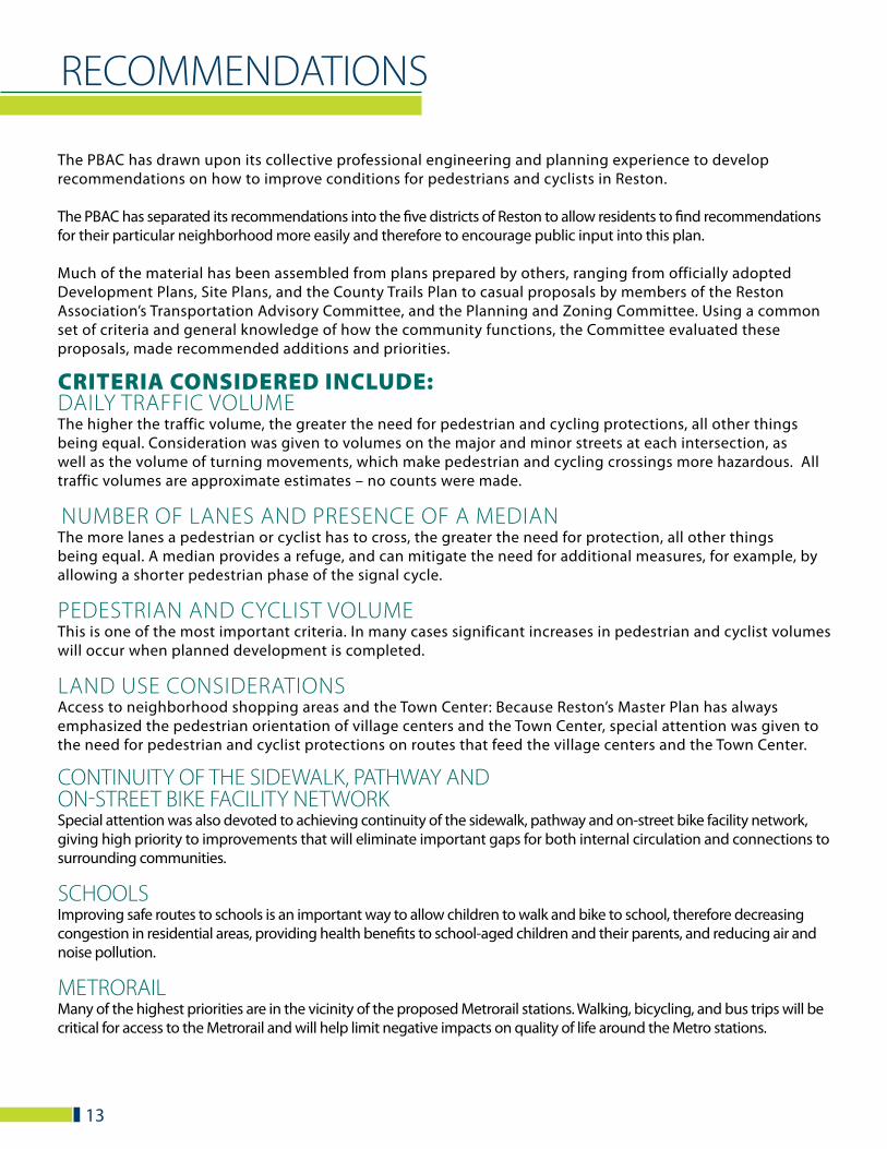
REFUGE ISLANDSA Pedestrian Refuge Island, also known as a crossing island, center island, median refuge area, pedestrian island, or median slow point, is a raised island placed in the street at an intersection or midblock to separate crossing pedestrians from motor vehicles.
According to the (Federal Highway Administration), providing raised medians or pedestrian refuge areas at pedestrian crossings at marked crosswalks has demonstrated a 46% reduction in pedestrian crashes. Installing such raised channelization on approaches to multi-lane intersections has been shown to be particularly effective. At unmarked crosswalk locations, medians have demonstrated a 39% reduction in pedestrian crashes. Medians are especially important in areas where pedestrians access a transit stop or other clear origin/destinations across from each other. Midblock locations account for over 70% of pedestrian fatalities. Also it is where vehicle travel speeds are higher which contributes to the injury and fatality rate at this location. Over 80% of pedestrians die when hit by vehicles traveling at 40 mph or faster while less than 20% die when hit at 20 mph.
The FHWA recommends raised medians (or pedestrian refuge areas) be considered in curbed sections of multi-lane urban roadways, particularly where pedestrians, high traffic volumes (exceeding 12,000 average daily trips per day), and intermediate or high travel speeds occur together. Medians/refuge islands should be at least 4 feet wide, but preferably 8 feet for pedestrian and bicycle comfort and safety. They should also be of adequate length to allow the anticipated number of pedestrians and bicyclists to stand and wait for gaps in traffic before crossing the second half of the street.
‘Safety Effects of Marked vs. Unmarked Crosswalks at Uncontrolled Locations’, p. 55. Federal Highway Administration. 2002
10
BICYCLE FACILITIES
BIKE LANES Bike lanes are markings for the preferential or exclusive use of bicyclists. Bike lanes enable bicyclists to ride at their preferred speed without interference from prevailing traffic conditions and facilitate predictable behavior and movements between bicyclists and motorists. Conventional bike lanes run curbside when no parking is present, adjacent to parked cars on the right-hand side of the street or on the left-hand side of the street in specific situations. Bike lanes typically run in the same direction of traffic, though they may be configured in the contra-flow direction on low-traffic corridors necessary for the connectivity of a particular bicycle route. The configuration of a bike lane requires a thorough consideration of existing traffic levels and behaviors, adequate safety buffers to protect bicyclists from parked and moving vehicles, and enforcement to prohibit motorized vehicle encroachment and double-parking. They also require good intersection design to reduce conflicts with motorists. Bike Lanes may be distinguished using color, lane markings, signage, and intersection treatments. (National Association City Transport Officials)
SHARED LANE MARKINGS/SHARROWSShared Lane Markings, or “sharrows,” are road markings used to indicate a shared lane environment for bicycles and automobiles. Among other benefits shared lane markings reinforce the legitimacy of bicycle traffic on the street and recommend proper bicyclist positioning. The shared lane marking is not a facility type, it is a pavement marking with a variety of uses to support a complete bikeway network. The Manual of Uniform Traffic Control Devices outlines guidance for shared lane markings in section 9C.07. (National Association City Transport Officials)
BUFFERED BIKE LANES Buffered bike lanes are conventional bicycle lanes paired with a designated buffer space separating the bicycle lane from the adjacent motor vehicle travel lane and/or parking lane. A buffered bike lane is allowed as per Manual of Uniform Traffic Control Devices guidelines for buffered preferential lanes (section 3D-01). (National Association City Transport Officials)
CYCLE TRACKSA cycle track is an exclusive bike facility that combines the user experience of a separated path with the on-street infrastructure of a conventional bike lane. A cycle track is physically separated from motor traffic and distinct from the sidewalk. Cycle tracks have different forms but all share common elements—they provide space that is intended to be exclusively or primarily used for bicycles, and are separated from motor vehicle travel lanes, parking lanes, and sidewalks. In situations where on-street parking is allowed cycle tracks are located to the curb-side of the parking (in contrast to bike lanes).Cycle tracks may be one-way or two-way, and may be at street level, at sidewalk level, or at an intermediate level. If at sidewalk level, a curb or median separates them from motor traffic, while different pavement color/texture separates the cycle track from the sidewalk. If at street level, they can be separated from motor traffic by raised medians, on-street parking, or bollards. By separating cyclists from motor traffic, cycle tracks can offer a higher level of security than bike lanes and are attractive to a wider spectrum of the public.(National Association City Transport Officials)
11

12
INTERSECTION TREATMENTSIntersections are junctions at which different modes of transportation meet and facilities overlap. An intersection facilitates the interchange between bicyclists, motorists, pedestrians, and other competing modes in order to advance traffic flow in a safe and efficient manner. Designs for intersections with bicycle facilities should reduce conflict between bicyclists (and other vulnerable road users) and motor vehicles by heightening the level of visibility, denoting a clear right-of-way, and facilitating eye contact and awareness with competing modes. Intersection treatments can resolve both queuing and merging maneuvers for bicyclists, and are often coordinated with timed or specialized signals.
The configuration of a safe intersection for bicyclists may include elements such as color, signage, medians, signal detection, and pavement markings. Intersection design should take into consideration existing and anticipated bicyclist, pedestrian and motorist movements. In all cases, the degree of mixing or separation between bicyclists and other modes is intended to reduce the risk of crashes and increase bicyclist comfort. The level of treatment required for bicyclists at an intersection will depend on the bicycle facility type used, whether bicycle facilities are intersecting, the adjacent street function and land use. (National Association City Transport Officials)
BICYCLE WAYFINDING SYSTEMA bicycle wayfinding system consists of comprehensive signing and/or pavement markings to guide bicyclists to their destinations along preferred bicycle routes. Signs are typically placed at decision points along bicycle routes – typically at the intersection of two or more bikeways and at other key locations leading to and along bicycle routes. (National Association City Transport Officials)
SHARE THE ROAD SIGNSIn situations where there is a need to warn drivers to watch for other slower forms of transportation traveling along the highway, such as bicycles (…) a SHARE THE ROAD plaque may be used. (Manual of Uniform Traffic Control Devices)
BICYCLE PARKINGThe lack of a secure parking space keeps many people from using their bikes for basic transportation. Leaving a bicycle unattended, even for short periods, can easily result in damage or theft. Finding a bike rack that doesn’t work or isn’t conveniently located makes for a frustrating experience. All bike parking facilities in Reston should follow the bicycle parking guidelines of the Association of Pedestrian and Bicycle Professionals: http://www.apbp.org/resource/resmgr/publications/bicycle_parking_guidelines.pdf
RECOMMENDATIONS
The PBAC has drawn upon its collective professional engineering and planning experience to develop recommendations on how to improve conditions for pedestrians and cyclists in Reston.
The PBAC has separated its recommendations into the five districts of Reston to allow residents to find recommendations for their particular neighborhood more easily and therefore to encourage public input into this plan.
Much of the material has been assembled from plans prepared by others, ranging from officially adopted Development Plans, Site Plans, and the County Trails Plan to casual proposals by members of the Reston Association’s Transportation Advisory Committee, and the Planning and Zoning Committee. Using a common set of criteria and general knowledge of how the community functions, the Committee evaluated these proposals, made recommended additions and priorities.
CRITERIA CONSIDERED INCLUDE: DAILY TRAFFIC VOLUMEThe higher the traffic volume, the greater the need for pedestrian and cycling protections, all other things being equal. Consideration was given to volumes on the major and minor streets at each intersection, as well as the volume of turning movements, which make pedestrian and cycling crossings more hazardous. All traffic volumes are approximate estimates – no counts were made.
NUMBER OF LANES AND PRESENCE OF A MEDIAN The more lanes a pedestrian or cyclist has to cross, the greater the need for protection, all other things being equal. A median provides a refuge, and can mitigate the need for additional measures, for example, by allowing a shorter pedestrian phase of the signal cycle.
PEDESTRIAN AND CYCLIST VOLUME This is one of the most important criteria. In many cases significant increases in pedestrian and cyclist volumes will occur when planned development is completed.
LAND USE CONSIDERATIONSAccess to neighborhood shopping areas and the Town Center: Because Reston’s Master Plan has always emphasized the pedestrian orientation of village centers and the Town Center, special attention was given to the need for pedestrian and cyclist protections on routes that feed the village centers and the Town Center.
CONTINUITY OF THE SIDEWALK, PATHWAY AND ON-STREET BIKE FACILITY NETWORK Special attention was also devoted to achieving continuity of the sidewalk, pathway and on-street bike facility network, giving high priority to improvements that will eliminate important gaps for both internal circulation and connections to surrounding communities.
SCHOOLS Improving safe routes to schools is an important way to allow children to walk and bike to school, therefore decreasing congestion in residential areas, providing health benefits to school-aged children and their parents, and reducing air and noise pollution.
METRORAIL Many of the highest priorities are in the vicinity of the proposed Metrorail stations. Walking, bicycling, and bus trips will be critical for access to the Metrorail and will help limit negative impacts on quality of life around the Metro stations.
13
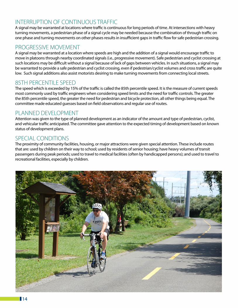
INTERRUPTION OF CONTINUOUS TRAFFICA signal may be warranted at locations where traffic is continuous for long periods of time. At intersections with heavy turning movements, a pedestrian phase of a signal cycle may be needed because the combination of through traffic on one phase and turning movements on other phases results in insufficient gaps in traffic flow for safe pedestrian crossing.
PROGRESSIVE MOVEMENTA signal may be warranted at a location where speeds are high and the addition of a signal would encourage traffic to move in platoons through nearby coordinated signals (i.e., progressive movement). Safe pedestrian and cyclist crossing at such locations may be difficult without a signal because of lack of gaps between vehicles. In such situations, a signal may be warranted to provide a safe pedestrian and cyclist crossing, even if pedestrian/cyclist volumes and cross traffic are quite low. Such signal additions also assist motorists desiring to make turning movements from connecting local streets.
85TH PERCENTILE SPEED The speed which is exceeded by 15% of the traffic is called the 85th percentile speed. It is the measure of current speeds most commonly used by traffic engineers when considering speed limits and the need for traffic controls. The greater the 85th percentile speed, the greater the need for pedestrian and bicycle protection, all other things being equal. The committee made educated guesses based on field observations and regular use of routes.
PLANNED DEVELOPMENTAttention was given to the type of planned development as an indicator of the amount and type of pedestrian, cyclist, and vehicular traffic anticipated. The committee gave attention to the expected timing of development based on known status of development plans.
SPECIAL CONDITIONSThe proximity of community facilities, housing, or major attractions were given special attention. These include routes that are: used by children on their way to school; used by residents of senior housing; have heavy volumes of transit passengers during peak periods; used to travel to medical facilities (often by handicapped persons); and used to travel to recreational facilities, especially by children.
14

PROPOSED INTERSECTION IMPROVEMENTSSORTED BY RESTON DISTRICT
15
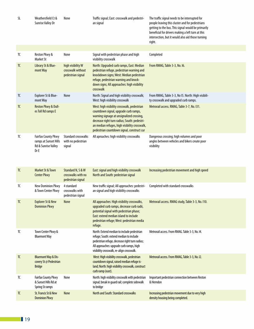
PRIORITY DISTRICT LOCATION EXISTING PEDESTRIAN PROTECTION RECOMMENDATION COMMENTS/LAND USE CONSIDERATIONS
HW Fairfax County Pkwy & Sunrise Valley Dr
Standard N, E & S crosswalks with no pedestrian signal
North, East, and South: high visibility cross-walks with pedestrian signal
Dangerous crossings; high volumes, turning move-ments & high speeds; substantial bike traffic
HW Sunrise Valley Dr & Wiehle Ave
Signal and standard N & W crosswalks with pedestrian signal
North and West: high visibility crosswalks Increasing pedestrian movement will occur when the rail station opens and planned new develop-ment begins
HW Sunrise Valley Dr & Reston Pkwy
Signal and standard W, S & E crosswalks with pedestrian signal
North: Channelized right turns; West: Re-align crosswalk; South: Re-align crosswalk; East: re-align crosswalk, channelize right turns, decrease right turn radius; All approaches: high visibility crosswalks, pedestrian countdown signals, upgrade curb ramps
Metrorail access. Dangerous crossing; high speeds and few pedestrian crossings in the area. RMAG study, Table 3-4 No. I13.
HW Sunrise Valley & Edmund Halley Dr
North: upgrade curb ramps; East: construct/upgrade curb ramps; West: construct/upgrade curb ramps; All approaches: high visibility crosswalks, pedestrian countdown signals, pedestrian median refuges.
Metrorail access. From RMAG, Table 3-7, No. I15.
HW Sunrise Valley Dr & Glade Dr
East: Pedestrian median refuge, upgrade or construct curb ramps; South: Re-align cross-walk, construct/upgrade curb ramps; West: Re-align crosswalk
Metrorail access. From RMAG, Table 3-7, No. I17.
HW Colts Neck & Sunrise Valley Dr
Signal and standard S & E crosswalks without pedestrian signal
West: Re-align stop bar, upgrade curb ramps; North: Upgrade 1 curb ramp; East: extend median to include pedestrian refuge; All approaches: pedestrian countdown signals, high visibility crosswalks.
Metrorail access. RMAG study, Table 3-7, No. I14.
HW Reston Parkway & Glade Dr
Traffic signal; all ap-proaches pedestrian signals & standard crosswalks
All approaches: high visibility crosswalks
HW Colts Neck & Glade Dr and nearby E & S underpasses
Standard S & E cross-walks with pedestrian signal
South and East: pedestrian signal; All approaches: high visibility crosswalks
HW Fox Mill Rd & Reston Pkwy
Signal high visibility crosswalk to connect proposed sidewalk with existing sidewalk
Proposed new workforce housing at Park & Ride site will substantially increase pedestrian volume.
HW Reston Parkway & Oslo Dr
None East: Bus stop pad; South: high visibility crosswalk
HW Glade Drive at Dogwood Elementary School
Standard crosswalk SE High visibility crosswalks at school entrances and change existing standard crosswalk to high visibility
Primary school crossing
HW Colts Neck Rd at 2 Hunters Woods Elementary School entrances
South: Standard crosswalk at school entrance
high visibility crosswalks at 2 entrances across Colts Necks; South: change existing standard crosswalk to high visibility crosswalk
Primary school crossing
HW Colts Neck Rd at Hunters Woods Village Center
None North and South: high visibility crosswalks across Colts Neck at entrances to village center
Connects residential and village center. New elderly housing planned for existing UCP church site
HW Lawyers Rd between Fox Mill Rd & Farrier Lane
None high visibility crosswalk with advance signs at entrance to new trail
Consider moving crosswalk to Tack Lane or Farrier Lane
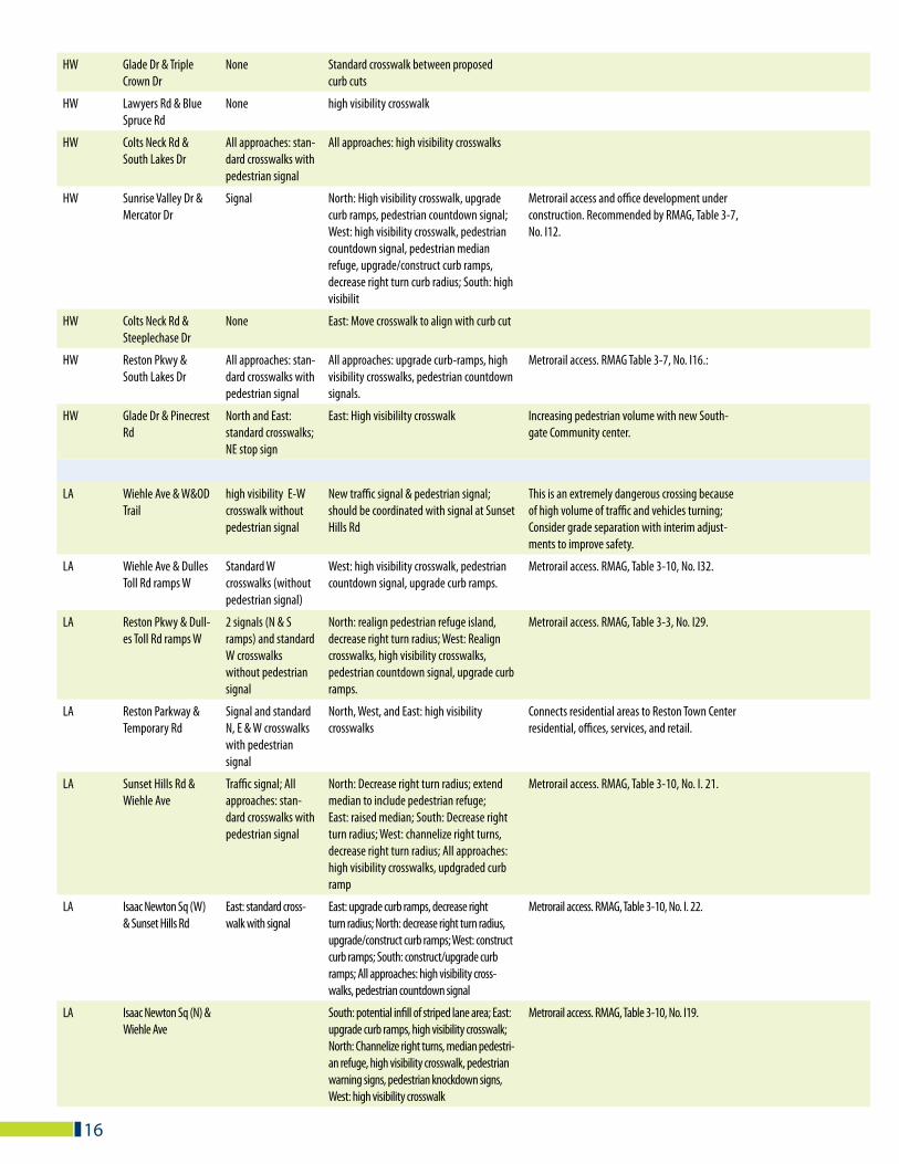
16
HW Glade Dr & Triple Crown Dr
None Standard crosswalk between proposed curb cuts
HW Lawyers Rd & Blue Spruce Rd
None high visibility crosswalk
HW Colts Neck Rd & South Lakes Dr
All approaches: stan-dard crosswalks with pedestrian signal
All approaches: high visibility crosswalks
HW Sunrise Valley Dr & Mercator Dr
Signal North: High visibility crosswalk, upgrade curb ramps, pedestrian countdown signal; West: high visibility crosswalk, pedestrian countdown signal, pedestrian median refuge, upgrade/construct curb ramps, decrease right turn curb radius; South: high visibilit
Metrorail access and office development under construction. Recommended by RMAG, Table 3-7, No. I12.
HW Colts Neck Rd & Steeplechase Dr
None East: Move crosswalk to align with curb cut
HW Reston Pkwy & South Lakes Dr
All approaches: stan-dard crosswalks with pedestrian signal
All approaches: upgrade curb-ramps, high visibility crosswalks, pedestrian countdown signals.
Metrorail access. RMAG Table 3-7, No. I16.:
HW Glade Dr & Pinecrest Rd
North and East: standard crosswalks; NE stop sign
East: High visibililty crosswalk Increasing pedestrian volume with new South-gate Community center.
LA Wiehle Ave & W&OD Trail
high visibility E-W crosswalk without pedestrian signal
New traffic signal & pedestrian signal; should be coordinated with signal at Sunset Hills Rd
This is an extremely dangerous crossing because of high volume of traffic and vehicles turning; Consider grade separation with interim adjust-ments to improve safety.
LA Wiehle Ave & Dulles Toll Rd ramps W
Standard W crosswalks (without pedestrian signal)
West: high visibility crosswalk, pedestrian countdown signal, upgrade curb ramps.
Metrorail access. RMAG, Table 3-10, No. I32.
LA Reston Pkwy & Dull-es Toll Rd ramps W
2 signals (N & S ramps) and standard W crosswalks without pedestrian signal
North: realign pedestrian refuge island, decrease right turn radius; West: Realign crosswalks, high visibility crosswalks, pedestrian countdown signal, upgrade curb ramps.
Metrorail access. RMAG, Table 3-3, No. I29.
LA Reston Parkway & Temporary Rd
Signal and standard N, E & W crosswalks with pedestrian signal
North, West, and East: high visibility crosswalks
Connects residential areas to Reston Town Center residential, offices, services, and retail.
LA Sunset Hills Rd & Wiehle Ave
Traffic signal; All approaches: stan-dard crosswalks with pedestrian signal
North: Decrease right turn radius; extend median to include pedestrian refuge; East: raised median; South: Decrease right turn radius; West: channelize right turns, decrease right turn radius; All approaches: high visibility crosswalks, updgraded curb ramp
Metrorail access. RMAG, Table 3-10, No. I. 21.
LA Isaac Newton Sq (W) & Sunset Hills Rd
East: standard cross-walk with signal
East: upgrade curb ramps, decrease right turn radius; North: decrease right turn radius, upgrade/construct curb ramps; West: construct curb ramps; South: construct/upgrade curb ramps; All approaches: high visibility cross-walks, pedestrian countdown signal
Metrorail access. RMAG, Table 3-10, No. I. 22.
LA Isaac Newton Sq (N) & Wiehle Ave
South: potential infill of striped lane area; East: upgrade curb ramps, high visibility crosswalk; North: Channelize right turns, median pedestri-an refuge, high visibility crosswalk, pedestrian warning signs, pedestrian knockdown signs, West: high visibility crosswalk
Metrorail access. RMAG, Table 3-10, No. I19.
17
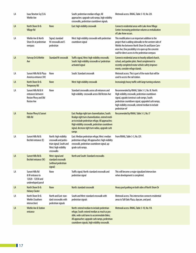
LA Isaac Newton Sq (S) & Wiehle Ave
South: pedestrian median refuge; All approaches: upgrade curb ramps, high visibility crosswalks, pedestrian countdown signals.
Metrorail access. RMAG, Table 3-10, No. I20.
LA North Shore Dr & Village Rd
None East: high visibility crosswalk Connects residential areas with Lake Anne Village Center. Increasing pedestrian volume as revitalization of Lake Anne occurs.
LA Wiehle Ave & North Shore Dr at pedestrian overpass
Signal; standard W crosswalk and S pedestrian
West: high visibility crosswalk with pedestrian countdown signal
This modification is an important addition to the project that is adding sidewalks to the western side of Wiehle Ave between North Shore Dr and Baron Cam-eron Ave; One possibility is to open up the concrete wall for direct access to the pedestrian overpass
LA Fairway Dr & Wiehle Ave
Standard W crosswalk Traffic signal, West: high visibility crosswalk; South: high visibility crosswalk w/ pedestrian activated signal
Connects residential areas to heavily utilized church, school, and garden plots. Need complement to recently completed motor vehicle safety improve-ments; consider refuge islands.
LA Sunset Hills Rd & Plaza America entrance (W)
None South: Standard crosswalk Metrorail access. This is part of the route that will be used to access the rail station.
LA North Shore Dr & Temporary Rd
None West: high visibility crosswalk Increasingly heavy traffic with large turning volumes
LA Sunset Hills Rd & N entrances between Reston Pkwy and Old Reston Ave
None Standard crosswalks across all entrances and high visibility crosswalk across Old Reston Ave
Recommended by RMAG, Table 3-3, No. I8. North: High visibility crosswalk, pedestrian countdown signal, ugrade/construct curb ramps; South: pedestrian countdown signal, upgraded curb ramps, high visibility crosswalk, extend median to include pedestrian ref
LA Reston Pkwy & Sunset Hills Rd
East: Realign right turn channelization; South: Realign right turn channelization, extend medi-an to include pedestrian refuge; All approaches: High visibility crosswalk, pedestrian countdown signal, decrease right turn radius, upgrade curb ramps
Reccomended by RMAG. Table 3-3, No. I7
LA Sunset Hills Rd & Bechtel entrance (E)
North: high visibility crosswalk and pedes-trian signal; South and West: high visibility crosswalks
East: Median pedestrian refuge; West: median pedestrian refuge; All approaches: high visibility crosswalk, pedestrian countdown signal, up-grade curb ramps.
From RMAG, Table 3-3, No. I29.
LA Sunset Hills Rd & Bechtel entrance (W)
West: signal and standard crosswalk (without pedestrian signal)
North and South: Standard crosswalks
LA Sunset Hills Rd & W entrance to 12020 - 12030 and undeveloped parcel
None Traffic signal; North: standard crosswalk and pedestrian signal
This will become a major signalized intersection when development is completed.
LA North Shore Dr & Hickory Cluster
None North: standard crosswalk Heavy pool parking on both sides of North Shore Dr
LA North Shore Dr & Wiehle (Southern intersection)
North and East: stan-dard crosswalks with pedestrian signals
South and West: standard crosswalk with pedestrian signals
Metrorail access. This intersection connects residential areas to Tall Oaks Plaza, daycare, and pool.
LA Wiehle Ave & Station entrance
North: extend median to include pedestrian refuge; South: extend median as much as pos-sible, wide curb lanes to accommodate bikes; All approaches: upgrade curb ramps, pedestrian countdown signals, high visibility crosswalk.
Metrorail access. RMAG, Table 3-10, No. I18.
18
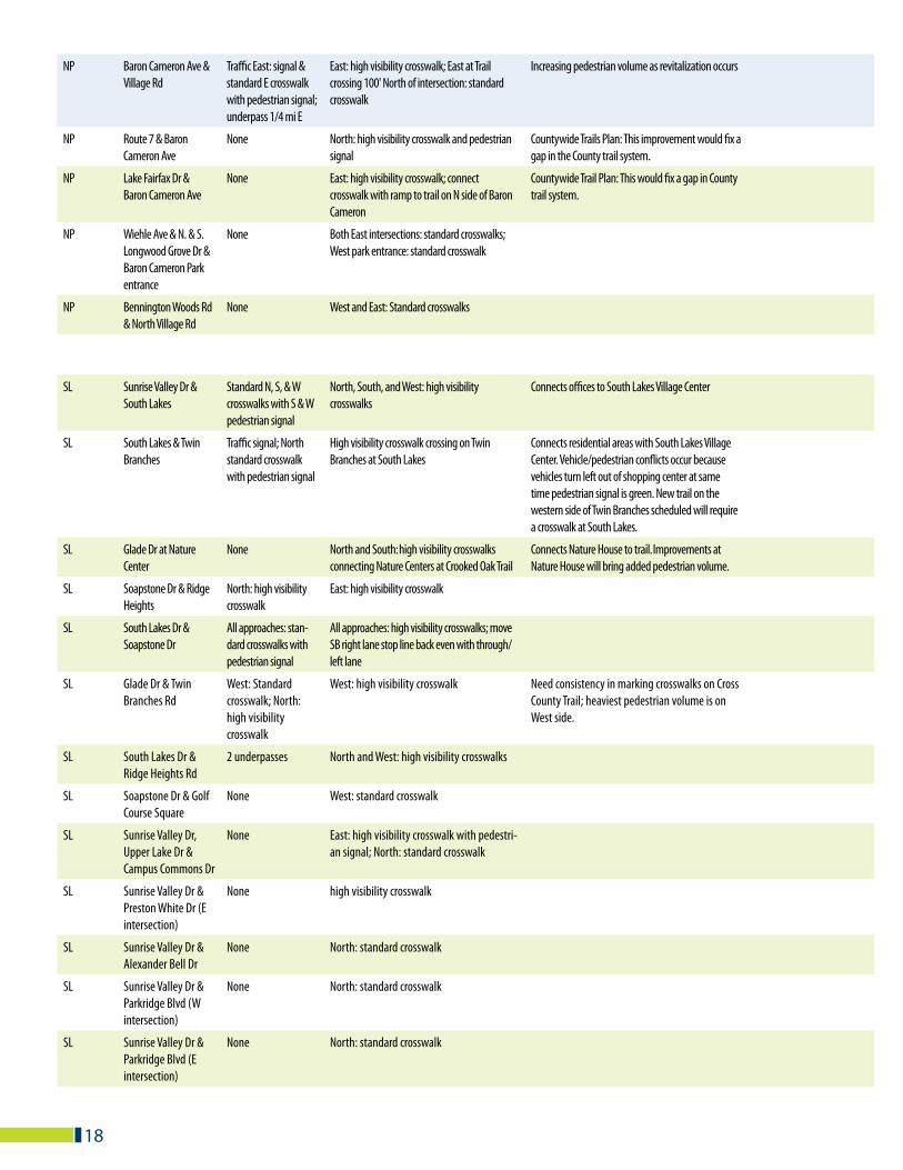
NP Baron Cameron Ave & Village Rd
Traffic East: signal & standard E crosswalk with pedestrian signal; underpass 1/4 mi E
East: high visibility crosswalk; East at Trail crossing 100' North of intersection: standard crosswalk
Increasing pedestrian volume as revitalization occurs
NP Route 7 & Baron Cameron Ave
None North: high visibility crosswalk and pedestrian signal
Countywide Trails Plan: This improvement would fix a gap in the County trail system.
NP Lake Fairfax Dr & Baron Cameron Ave
None East: high visibility crosswalk; connect crosswalk with ramp to trail on N side of Baron Cameron
Countywide Trail Plan: This would fix a gap in County trail system.
NP Wiehle Ave & N. & S. Longwood Grove Dr & Baron Cameron Park entrance
None Both East intersections: standard crosswalks; West park entrance: standard crosswalk
NP Bennington Woods Rd & North Village Rd
None West and East: Standard crosswalks
SL Sunrise Valley Dr & South Lakes
Standard N, S, & W crosswalks with S & W pedestrian signal
North, South, and West: high visibility crosswalks
Connects offices to South Lakes Village Center
SL South Lakes & Twin Branches
Traffic signal; North standard crosswalk with pedestrian signal
High visibility crosswalk crossing on Twin Branches at South Lakes
Connects residential areas with South Lakes Village Center. Vehicle/pedestrian conflicts occur because vehicles turn left out of shopping center at same time pedestrian signal is green. New trail on the western side of Twin Branches scheduled will require a crosswalk at South Lakes.
SL Glade Dr at Nature Center
None North and South: high visibility crosswalks connecting Nature Centers at Crooked Oak Trail
Connects Nature House to trail. Improvements at Nature House will bring added pedestrian volume.
SL Soapstone Dr & Ridge Heights
North: high visibility crosswalk
East: high visibility crosswalk
SL South Lakes Dr & Soapstone Dr
All approaches: stan-dard crosswalks with pedestrian signal
All approaches: high visibility crosswalks; move SB right lane stop line back even with through/left lane
SL Glade Dr & Twin Branches Rd
West: Standard crosswalk; North: high visibility crosswalk
West: high visibility crosswalk Need consistency in marking crosswalks on Cross County Trail; heaviest pedestrian volume is on West side.
SL South Lakes Dr & Ridge Heights Rd
2 underpasses North and West: high visibility crosswalks
SL Soapstone Dr & Golf Course Square
None West: standard crosswalk
SL Sunrise Valley Dr, Upper Lake Dr & Campus Commons Dr
None East: high visibility crosswalk with pedestri-an signal; North: standard crosswalk
SL Sunrise Valley Dr & Preston White Dr (E intersection)
None high visibility crosswalk
SL Sunrise Valley Dr & Alexander Bell Dr
None North: standard crosswalk
SL Sunrise Valley Dr & Parkridge Blvd (W intersection)
None North: standard crosswalk
SL Sunrise Valley Dr & Parkridge Blvd (E intersection)
None North: standard crosswalk
19
SL Weathersfield Ct & Sunrise Valley Dr
None Traffic signal; East: crosswalk and pedestri-an signal
The traffic signal needs to be interrupted for people leaving this cluster and for pedestrians getting to the bus. This signal would be primarily beneficial for drivers making a left turn at this intersection, but it would also aid those turning right.
TC Reston Pkwy & Market St
None Signal with pedestrian phase and high visibility crosswalk
Completed
TC Library St & Blue-mont Way
high visibility W crosswalk without pedestrian signal
North: Upgraded curb ramps, East: Median pedestrian refuge, pedestrian warning and knockdown signs; West: Median pedestrian refuge, pedestrian warning and knock-down signs; All approaches: high visibility crosswalk
From RMAG, Table 3-3, No. I6.
TC Explorer St & Blue-mont Way
None North: Signal and high visibility crosswalk; West: high visibility crosswalk
From RMAG, Table 3-3, No I5. North: High visibili-ty crosswalk and upgraded curb ramps.
TC Reston Pkwy & Dull-es Toll Rd ramps E
West: high visibility crosswalk, pedestrian countdown signal, upgrade curb ramps, warning signage at unsignalized crossing, decrease right turn radius; South: pedestri-an median refuges, high visibility crosswalk, pedestrian countdown signal, construct cur
Metrorail access. RMAG, Table 3-7, No. I31.
TC Fairfax County Pkwy ramps at Sunset Hills Rd & Sunrise Valley Dr E
Standard crosswalks with no pedestrian signal
All aproaches: high visibility crosswalks Dangerous crossing; high volumes and poor angles between vehicles and bikers create poor visibility
TC Market St & Town Center Pkwy
Standard N, S & W crosswalks with no pedestrian signal
East: signal and high visibility crosswalk North and South: pedestrian signal
Increasing pedestrian movement and high speed
TC New Dominion Pkwy & Town Center Pkwy
4 standard crosswalks with pedestrian signal
New traffic signal; All approaches: pedestri-an signal and high visibility crosswalks
Completed with standard crosswalks
TC Explorer St & New Dominion Pkwy
None All approaches: High visibility crosswalks, upgraded curb ramps, decrease curb radii, potential signal with pedestrian phase; East: extend median island to include pedestrian refuge; West: pedestrian media refuge.
Metrorail access. RMAG study, Table 3-3, No. I10.
TC Town Center Pkwy & Bluemont Way
North: Extend median to include pedestrian refuge; South: extend median to include pedestrian refuge, decrease right turn radius; All approaches: upgrade curb ramps, high visibility crosswalk, re-align crosswalk.
Metrorail access. From RMAG. Table 3-3, No. I4.
TC Bluemont Way & Dis-covery St @ Pedestrian Bridge
West: High visibility crosswalk, pedestrian countdown signal, raised median refuge is-land; North: high visibility crosswalk, construct curb ramp (east).
Metrorail access. From RMAG, Table 3-3, No. I2.
TC Fairfax County Pkwy & Sunset Hills Rd at Spring St ramps
None North: high visibility crosswalk with pedestrian signal; break in guard rail; complete sidewalk to bridge
Important pedestrian connection between Reston & Herndon
TC St. Francis St & New Dominion Pkwy
None North and South: Standard crosswalks Increasing pedestrian movement due to very high density housing being completed.
20
TC Fountain Dr & Baron Cameron Ave
East: standard crosswalk and pedes-trian signal; North and South: standard crosswalks
North: pedestrian signal Increasing pedestrian movement due to new development.
TC St. Francis St & Bluemont Way
None North: high visibility crosswalk Increasing pedestrian movement between bus tran-sit station, coming rail station, and Town Center core
TC Town Center Pkwy & Sunset Hills Rd
Signal All approaches: High visibility crosswalk, extend median to include pedestrian refuge, pedestrian countdown signal, construct curb ramps
Metrorail access. Recommended by RMAG, Table 3-3, No. I3
TC New Dominion Pkwy & Crescent Park Dr
None North and South: standard crosswalks Increasing pedestrian movement
TC Town Center Pkwy & Cameron Glen Dr
None West, South, and East: standard crosswalks
TC Bowman Towne Dr & Cameron Glen Dr
West: standard crosswalk
North and South: standard crosswalks with pedestrian signal
TC Bowman Towne Dr & Fountain Dr
All approaches: stop signs; South, East and West: standard crosswalks
North: standard crosswalk Increasing pedestrian volume
TC Bowman Towne Dr & Explorer St.
None North and South: standard crosswalks Number of people walking in this location is increasing
TC Sunset Hills Rd & YMCA entrance (W)
None Standard NE crosswalk Connects retail area, YMCA, hotel, access to W&OD trail, gas station, and restaurants.
TC Sunset Hills @ Target Driveway
All approaches: high visibility crosswalks, countdown signals, upgraded curb ramps; East: Extend medians to include pedestrian refuge, re-align crosswalk.
Metrorail access. Connects retail in Herndon to Target, gas station, and retail areas to North. From RMAG, Table 3-3, No. I9.
50 TC Bowman Towne Dr & Explorer St.
None North and South: standard crosswalks Number of people walking in this location is increasing
64 TC Sunset Hills Rd & YMCA entrance (W)
None Standard NE crosswalk Connects retail area, YMCA, hotel, access to W&OD trail, gas station, and restaurants.
98 TC Sunset Hills @ Target Driveway
All approaches: high visibility crosswalks, countdown signals, upgraded curb ramps; East: Extend medians to include pedestrian refuge, re-align crosswalk.
Metrorail access. Connects retail in Herndon to Target, gas station, and retail areas to North. From RMAG, Table 3-3, No. I9.
KEY: CTP - Countywide Trails Plan, As adopted by the Fairfax County Board of Supervisors, June 17, 2002
RMAG - Reston Metrorail Access Group: Refer to the report, Wiehle Avenue/Reston Parkway Station Access Management Plans, Final Report, April 15, 2008, Submitted to Fairfax County, VA by Vanasse Hangen Brustlin, Inc. On-line at: http://www.fairfaxcounty.gov/fcdot/sam_meetings.htm)
HW - Hunters Woods
SL- South Lakes
LA- Lake Anne
NP - North Point
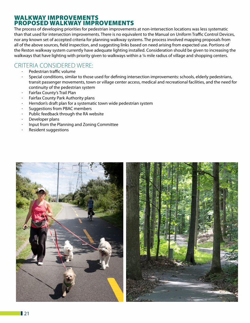
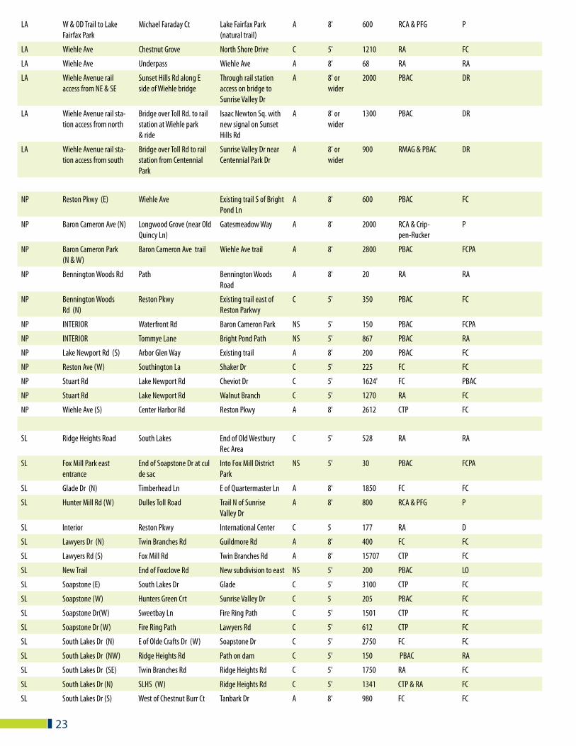
WALKWAY IMPROVEMENTSPROPOSED WALKWAY IMPROVEMENTSThe process of developing priorities for pedestrian improvements at non-intersection locations was less systematic than that used for intersection improvements. There is no equivalent to the Manual on Uniform Traffic Control Devices, nor any known set of accepted criteria for planning walkway systems. The process involved mapping proposals from all of the above sources, field inspection, and suggesting links based on need arising from expected use. Portions of the Reston walkway system currently have adequate lighting installed. Consideration should be given to increasing the walkways that have lighting with priority given to walkways within a ¼ mile radius of village and shopping centers.
CRITERIA CONSIDERED WERE:· Pedestrian traffic volume · Special conditions, similar to those used for defining intersection improvements: schools, elderly pedestrians,
transit passenger movements, town or village center access, medical and recreational facilities, and the need for continuity of the pedestrian system
· Fairfax County’s Trail Plan · Fairfax County Park Authority plans · Herndon’s draft plan for a systematic town wide pedestrian system · Suggestions from PBAC members · Public feedback through the RA website· Developer plans · Input from the Planning and Zoning Committee · Resident suggestions
21
DISTRICT ROUTE FROM TO SURFACE WIDTH LENGTH SOURCE RESPONSIBILITY
HW Glade Dr (E) Coquina Dr (S) Near Sunrise Valley Dr C 5' 500 PBAC FC
HW Glade Dr (N) Colts Neck Rd Shire Ct C 5' 850 FC FC
HW Glade Dr (N) Glade Bank Way Middle Creek Ln A 8' 500 FC FC
HW Glade Dr (S) Reston Pkwy Freetown Dr C 5' 300 PBAC FC
HW Glade Dr (W) Green Range Dr (N&S) Bus stops C 5' 50' each PBAC FC
HW Glade Dr (S&W) Green Range Dr (S) Rosedown Dr C 5' 2050 FC FC
HW INTERIOR Steeplechase Dr Fox Mill District Park NS 5' 1400 PBAC RA
HW OVER TOLL ROAD International Center Plaza America/Oracle C 10' 1200 PBAC FC
HW Lawyers Rd(N) Farrier Lane Park and Ride Path A 8' 294 PBAC FC
HW Reston Parkway (OVER) International Center Nextel Building C 8' 500 PBAC FC
HW Monroe Street (E) Sunrise Valley Dr Bridge over Toll Rd & Herndon
A/C 8' 2100 Herndon & PFG FCDOT
HW Town Center Station Sunrise Valley Dr Sunset Hills Road A 10 1700 RMAG FC
HW Town Center Station Reston Parkway Town Center Station A 10 1300 RMAG FC
HW Reston Parkway (W) Fox Mill Road Sunrise Valley Drive A 8' 9000 PBAC FC
HW South Lake Dr(N) Sanibel Ct Sunrise Valley Dr A 8' 3,400 CTP FC
HW South Lakes Dr (N) Cascade Exec Ctr Entrance Sanibel Dr C 5' 900 PBAC FC
HW South Lakes Dr (S) Pinecrest Rd 50' W of Sanibel Dr C 5' 300 PBAC FC
HW Sunrise Valley Dr(N) Fairfax County Pkwy W&OD Trail C 10' 22,977 RMAG FC
HW Sunrise Valley Dr (N) Hitchcock Rd Colts Brook Drive A 8' 771 RA FC
HW Toll Road (S) Monroe Street Wiehle Avenue A 10 14792 RMAG FC
LA Baron Cameron Ave (S) Lake Fairfax Dr Route 7 A 8' 1400 RCA P
LA Dressage Dr End of Dressage Dr Into new development A 8' 200 FAC P
LA Interior Sycamore Valley Old Reston Ave C 8' 22 RA RA
LA Inter-parcel connection Roger Bacon Dr Business Center Dr C 6' 2,662 RMAG D
LA Isaac Newton Sq S Wiehle Ave Isaac Newton Sq W C 6' 1,211 RMAG D
LA North Shore Dr Tall Oaks Shopping Center Tall Oaks Shopping Center
C 5' 589 RA FC/D
LA North Shore Dr (N) Wiehle Ave Ring Road C 5' 500 PBAC FC
LA North Shore Dr (S) Wiehle Ave Wedge Dr C 5' 150 PBAC FC
LA North Shore Dr (N) Golf Course sidewalk/RA Path
GCI Recreation area C 5' 1445 PBAC FC
LA North Shore Dr (N) Charter Oak Ct Charter Oak sidewalk C 5' 971 PBAC FC
LA North Shore Dr (S) Sycamore Valley New Fannie Mae Path C 5' 776 RA FC
LA Plaza America entrance Trail along Sunset Hills Rd (S)
Crosswalk across Sunset Hills Rd
A 8' 25 FAC P
LA Sunset Hills Rd (N) Wiehle Avenue Business Center Dr C 6' 9,568 RMAG FC
LA Sunset Hills Rd W&OD Trail Michael Faraday Ct C 5' 480 FC FC
LA Sunset Hills Rd (N & S) W & OD Trail Hunter Mill Road A 8' 4500 RCA & PFG VDOT
LA Sunset Hills Rd (N) W&OD Trail Post Office entrance C 5' 400 PBAC FC
LA Sunset Hills Rd (N) Old Reston Ave New Condo C 5' 482 PBAC FC
LA Sunset Hills Rd (N) Business Center Drive Clay Lane C 5' 176 RA FC
PROPOSED WALKWAY IMPROVEMENTSSORTED BY RESTON DISTRICT
22
23
LA W & OD Trail to Lake Fairfax Park
Michael Faraday Ct Lake Fairfax Park (natural trail)
A 8' 600 RCA & PFG P
LA Wiehle Ave Chestnut Grove North Shore Drive C 5' 1210 RA FC
LA Wiehle Ave Underpass Wiehle Ave A 8' 68 RA RA
LA Wiehle Avenue rail access from NE & SE
Sunset Hills Rd along E side of Wiehle bridge
Through rail station access on bridge to Sunrise Valley Dr
A 8' or wider
2000 PBAC DR
LA Wiehle Avenue rail sta-tion access from north
Bridge over Toll Rd. to rail station at Wiehle park & ride
Isaac Newton Sq. with new signal on Sunset Hills Rd
A 8' or wider
1300 PBAC DR
LA Wiehle Avenue rail sta-tion access from south
Bridge over Toll Rd to rail station from Centennial Park
Sunrise Valley Dr near Centennial Park Dr
A 8' or wider
900 RMAG & PBAC DR
NP Reston Pkwy (E) Wiehle Ave Existing trail S of Bright Pond Ln
A 8' 600 PBAC FC
NP Baron Cameron Ave (N) Longwood Grove (near Old Quincy Ln)
Gatesmeadow Way A 8' 2000 RCA & Crip-pen-Rucker
P
NP Baron Cameron Park (N & W)
Baron Cameron Ave trail Wiehle Ave trail A 8' 2800 PBAC FCPA
NP Bennington Woods Rd Path Bennington Woods Road
A 8' 20 RA RA
NP Bennington Woods Rd (N)
Reston Pkwy Existing trail east of Reston Parkwy
C 5' 350 PBAC FC
NP INTERIOR Waterfront Rd Baron Cameron Park NS 5' 150 PBAC FCPA
NP INTERIOR Tommye Lane Bright Pond Path NS 5' 867 PBAC RA
NP Lake Newport Rd (S) Arbor Glen Way Existing trail A 8' 200 PBAC FC
NP Reston Ave (W) Southington La Shaker Dr C 5' 225 FC FC
NP Stuart Rd Lake Newport Rd Cheviot Dr C 5' 1624' FC PBAC
NP Stuart Rd Lake Newport Rd Walnut Branch C 5' 1270 RA FC
NP Wiehle Ave (S) Center Harbor Rd Reston Pkwy A 8' 2612 CTP FC
SL Ridge Heights Road South Lakes End of Old Westbury Rec Area
C 5' 528 RA RA
SL Fox Mill Park east entrance
End of Soapstone Dr at cul de sac
Into Fox Mill District Park
NS 5' 30 PBAC FCPA
SL Glade Dr (N) Timberhead Ln E of Quartermaster Ln A 8' 1850 FC FC
SL Hunter Mill Rd (W) Dulles Toll Road Trail N of Sunrise Valley Dr
A 8' 800 RCA & PFG P
SL Interior Reston Pkwy International Center C 5 177 RA D
SL Lawyers Dr (N) Twin Branches Rd Guildmore Rd A 8' 400 FC FC
SL Lawyers Rd (S) Fox Mill Rd Twin Branches Rd A 8' 15707 CTP FC
SL New Trail End of Foxclove Rd New subdivision to east NS 5' 200 PBAC LO
SL Soapstone (E) South Lakes Dr Glade C 5' 3100 CTP FC
SL Soapstone (W) Hunters Green Crt Sunrise Valley Dr C 5 205 PBAC FC
SL Soapstone Dr(W) Sweetbay Ln Fire Ring Path C 5' 1501 CTP FC
SL Soapstone Dr (W) Fire Ring Path Lawyers Rd C 5' 612 CTP FC
SL South Lakes Dr (N) E of Olde Crafts Dr (W) Soapstone Dr C 5' 2750 FC FC
SL South Lakes Dr (NW) Ridge Heights Rd Path on dam C 5' 150 PBAC RA
SL South Lakes Dr (SE) Twin Branches Rd Ridge Heights Rd C 5' 1750 RA FC
SL South Lakes Dr (N) SLHS (W) Ridge Heights Rd C 5' 1341 CTP & RA FC
SL South Lakes Dr (S) West of Chestnut Burr Ct Tanbark Dr A 8' 980 FC FC
HW Hunters Woods FAC Facilities Advisory Committee
CTP County Trails Plan
SL South Lakes RMAG Reston Metrorail Access Group
RA Reston Association
LA Lake Anne RCA Reston Citizens Association
RLC Reston Land Corporation
NP North Point PFG Pedestrian Facilities Group
P Private
PBAC Pedestrian and Bicycle Committee
FC Fairfax County
24
SL Sunrise Valley Dr(S) Glade Dr Barton Hill Road C 6' 17,000 RMAG FC
SL Sunrise Valley Dr (S) W&OD Trail Hunter Mill Rd A 8' 2675 FC FC
SL Twin Branches (E)/Lawyers(N)
Bradford Rd Hunter Station A 8' 1246 PBAC RA
SL Twin Branches Rd (E) Glade Dr 50' S of Sentinel Point Ct
C 5' 1500 PBAC FC
SL Twin Branches Rd (W) South Lakes Dr 75' N of Beacon Ridge C 5' 950 RA FC
SL Wiehle Avenue Station Sunrise Valley Drive Wiehle Avenue Station A 10 2000 RMAG FC
TC Town Center rail station access from NE & SE
Oracle site along E side of Reston Pkwy Bridge
Through rail station access on bridge to Sheraton & Intl. Ctr.
A 8' or wider
1000 PBAC FC
TC Town Center rail station access from Town Center
Bridge over Toll Rd. to rail station at TRW site
Bridge over W&OD Trail to Bluemont Way at Discovery St
A 8' or wider
1800 PBAC FC
TC Town Center rail station access from south
Bridge over Toll Rd. to rail station at Carr site
Sunrise Valley Drive through Unisys site
A 8' or wider
2000 PBAC FC
TC W&OD Trail to Town Center to & from west
Town Center Pkwy West of Town Center Pkwy
A 8' 500 PBAC FC
TC W&OD Trail to Town Center to & from east
Trail under Reston Pkwy Discovery St & Blue-mont by ramp
A 8' 400 PBAC FC
TC Sunset Hills Rd (S) End of ramp from Fairfax Co. Pkwy
Herndon C 5' 700 PBAC FC
TC Bluemont Way Reston Pkwy Discovery St C 6' 1,894 RMAG FC
TC Town Center Pkwy W&OD Trail Sunset Hills Rd C 6' 810 RMAG FC
TC Reston Parkway (E) Dulles Toll Rd (bridge to rail station)
1801 Reston Pkwy A 8' 2100 RLC P
TC Explorer St (E) Bowman Towne Dr New Dominion Pkway C 6' 425 RLC P
TC Fountain Dr (W) Access Sunrise House C 5' 500 RLC P
TC New Dominion Pkwy (N&S)
Town Center Pkwy Fairfax County Pkwy C 6' 1300 RLC FC
TC Bluemont Way (N&S) Town Center Pkwy Library St C 6' 1100 RLC FC
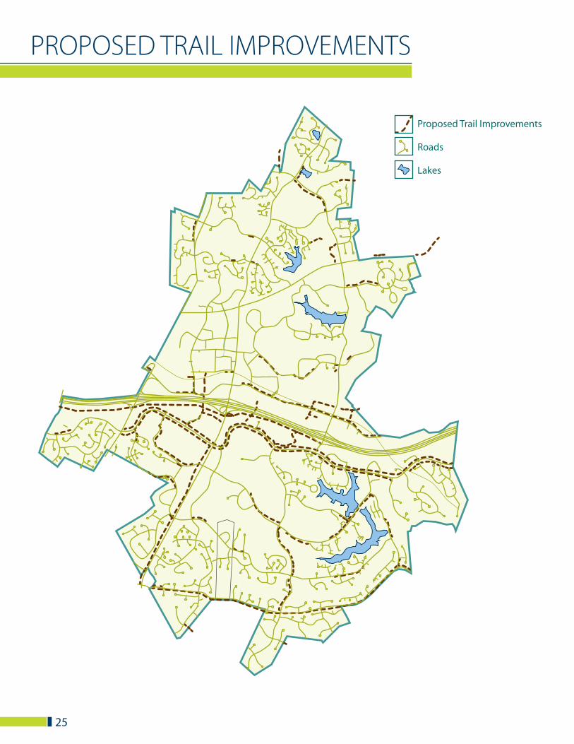
Proposed Trail Improvements
Roads
Lakes
PROPOSED TRAIL IMPROVEMENTS
25
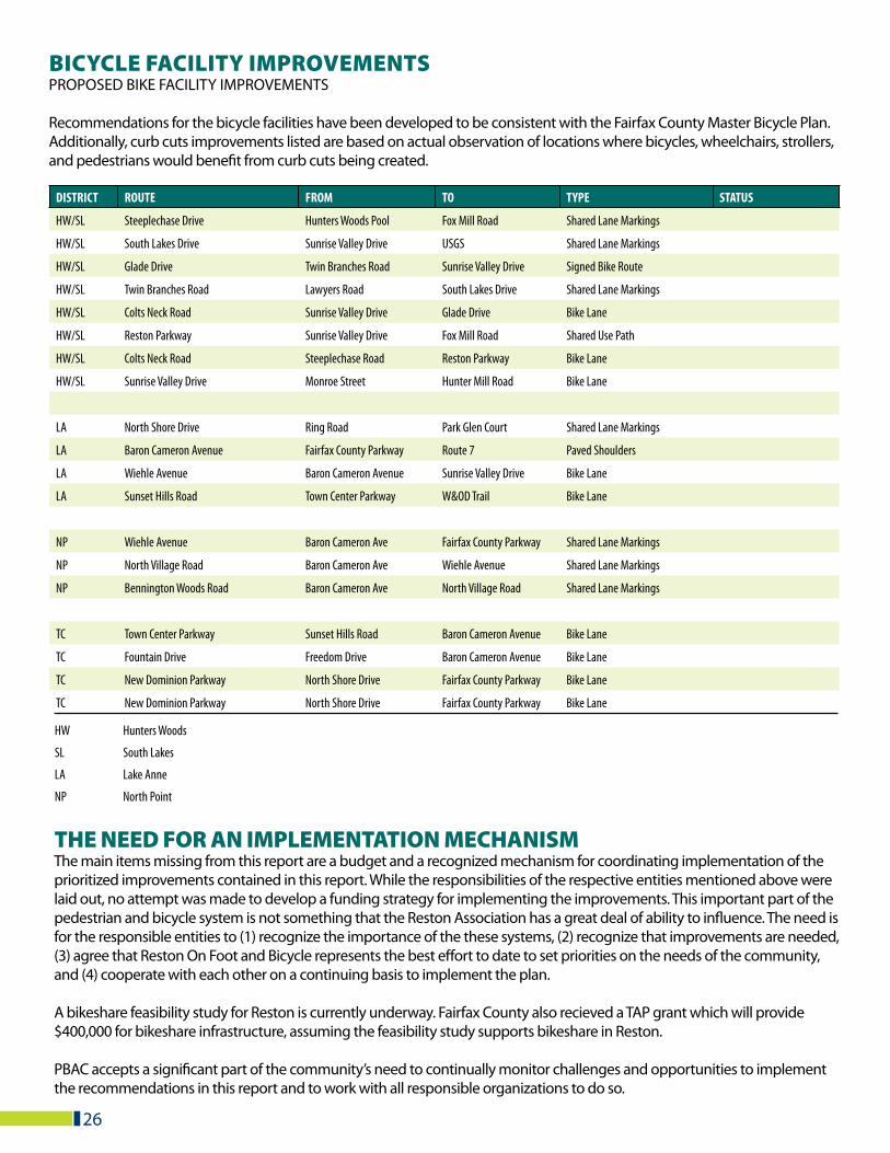
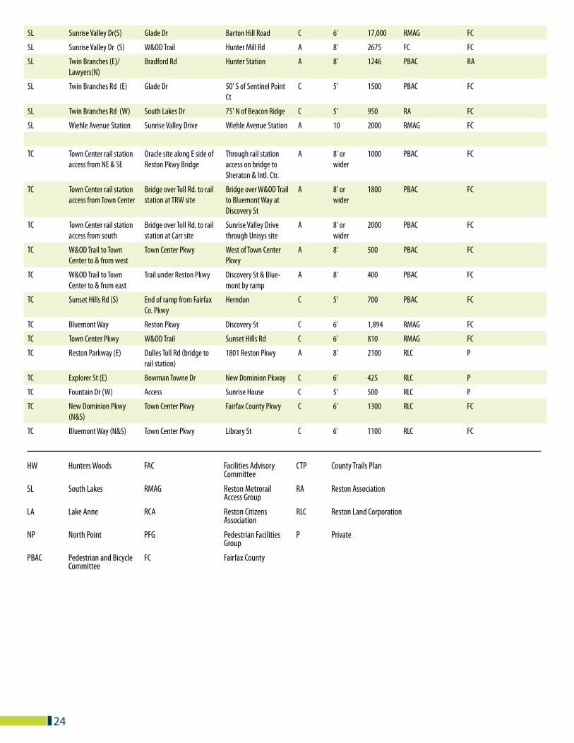
BICYCLE FACILITY IMPROVEMENTSPROPOSED BIKE FACILITY IMPROVEMENTS
Recommendations for the bicycle facilities have been developed to be consistent with the Fairfax County Master Bicycle Plan. Additionally, curb cuts improvements listed are based on actual observation of locations where bicycles, wheelchairs, strollers, and pedestrians would benefit from curb cuts being created.
26
DISTRICT ROUTE FROM TO TYPE STATUS
HW/SL Steeplechase Drive Hunters Woods Pool Fox Mill Road Shared Lane Markings
HW/SL South Lakes Drive Sunrise Valley Drive USGS Shared Lane Markings
HW/SL Glade Drive Twin Branches Road Sunrise Valley Drive Signed Bike Route
HW/SL Twin Branches Road Lawyers Road South Lakes Drive Shared Lane Markings
HW/SL Colts Neck Road Sunrise Valley Drive Glade Drive Bike Lane
HW/SL Reston Parkway Sunrise Valley Drive Fox Mill Road Shared Use Path
HW/SL Colts Neck Road Steeplechase Road Reston Parkway Bike Lane
HW/SL Sunrise Valley Drive Monroe Street Hunter Mill Road Bike Lane
LA North Shore Drive Ring Road Park Glen Court Shared Lane Markings
LA Baron Cameron Avenue Fairfax County Parkway Route 7 Paved Shoulders
LA Wiehle Avenue Baron Cameron Avenue Sunrise Valley Drive Bike Lane
LA Sunset Hills Road Town Center Parkway W&OD Trail Bike Lane
NP Wiehle Avenue Baron Cameron Ave Fairfax County Parkway Shared Lane Markings
NP North Village Road Baron Cameron Ave Wiehle Avenue Shared Lane Markings
NP Bennington Woods Road Baron Cameron Ave North Village Road Shared Lane Markings
TC Town Center Parkway Sunset Hills Road Baron Cameron Avenue Bike Lane
TC Fountain Drive Freedom Drive Baron Cameron Avenue Bike Lane
TC New Dominion Parkway North Shore Drive Fairfax County Parkway Bike Lane
TC New Dominion Parkway North Shore Drive Fairfax County Parkway Bike Lane
HW Hunters Woods
SL South Lakes
LA Lake Anne
NP North Point
THE NEED FOR AN IMPLEMENTATION MECHANISMThe main items missing from this report are a budget and a recognized mechanism for coordinating implementation of the prioritized improvements contained in this report. While the responsibilities of the respective entities mentioned above were laid out, no attempt was made to develop a funding strategy for implementing the improvements. This important part of the pedestrian and bicycle system is not something that the Reston Association has a great deal of ability to influence. The need is for the responsible entities to (1) recognize the importance of the these systems, (2) recognize that improvements are needed, (3) agree that Reston On Foot and Bicycle represents the best effort to date to set priorities on the needs of the community, and (4) cooperate with each other on a continuing basis to implement the plan.
A bikeshare feasibility study for Reston is currently underway. Fairfax County also recieved a TAP grant which will provide $400,000 for bikeshare infrastructure, assuming the feasibility study supports bikeshare in Reston.
PBAC accepts a significant part of the community’s need to continually monitor challenges and opportunities to implement the recommendations in this report and to work with all responsible organizations to do so.
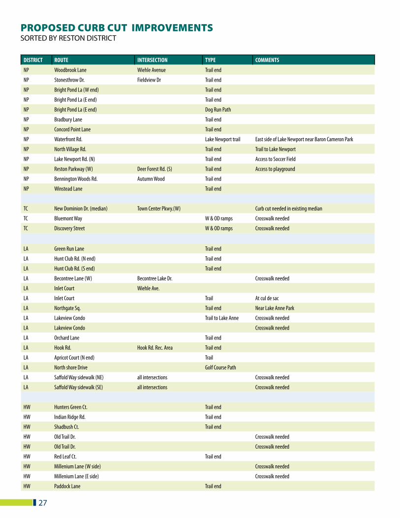
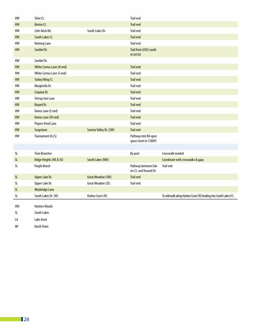
PROPOSED CURB CUT IMPROVEMENTSSORTED BY RESTON DISTRICT
DISTRICT ROUTE INTERSECTION TYPE COMMENTS
NP Woodbrook Lane Wiehle Avenue Trail end
NP Stonesthrow Dr. Fieldview Dr Trail end
NP Bright Pond La (W end) Trail end
NP Bright Pond La (E end) Trail end
NP Bright Pond La (E end) Dog Run Path
NP Bradbury Lane Trail end
NP Concord Point Lane Trail end
NP Waterfront Rd. Lake Newport trail East side of Lake Newport near Baron Cameron Park
NP North Village Rd. Trail end Trail to Lake Newport
NP Lake Newport Rd. (N) Trail end Access to Soccer Field
NP Reston Parkway (W) Deer Forest Rd. (S) Trail end Access to playground
NP Bennington Woods Rd. Autumn Wood Trail end
NP Winstead Lane Trail end
TC New Dominion Dr. (median) Town Center Pkwy.(W) Curb cut needed in existing median
TC Bluemont Way W & OD ramps Crosswalk needed
TC Discovery Street W & OD ramps Crosswalk needed
LA Green Run Lane Trail end
LA Hunt Club Rd. (N end) Trail end
LA Hunt Club Rd. (S end) Trail end
LA Becontree Lane (W) Becontree Lake Dr. Crosswalk needed
LA Inlet Court Wiehle Ave.
LA Inlet Court Trail At cul de sac
LA Northgate Sq. Trail end Near Lake Anne Park
LA Lakeview Condo Trail to Lake Anne Crosswalk needed
LA Lakeview Condo Crosswalk needed
LA Orchard Lane Trail end
LA Hook Rd. Hook Rd. Rec. Area Trail end
LA Apricot Court (N end) Trail
LA North shore Drive Golf Course Path
LA Saffold Way sidewalk (NE) all intersections Crosswalk needed
LA Saffold Way sidewalk (SE) all intersections Crosswalk needed
HW Hunters Green Ct. Trail end
HW Indian Ridge Rd. Trail end
HW Shadbush Ct. Trail end
HW Old Trail Dr. Crosswalk needed
HW Old Trail Dr. Crosswalk needed
HW Red Leaf Ct. Trail end
HW Millenium Lane (W side) Crosswalk needed
HW Millenium Lane (E side) Crosswalk needed
HW Paddock Lane Trail end
27
HW Shire Ct. Trail end
HW Breton Ct. Trail end
HW Colts Neck Rd. South Lakes Dr. Trail end
HW South Lakes Ct. Trail end
HW Nutmeg Lane Trail end
HW Sanibel Dr. Trail from USGS south to tot lot
HW Sanibel Dr.
HW White Cornus Lane (N end) Trail end
HW White Cornus Lane (S end) Trail end
HW Turkey Wing Ct. Trail end
HW Marginella Dr. Trail end
HW Coquina Dr. Trail end
HW Stirrup Iron Lane Trail end
HW Bayard Dr. Trail end
HW Darius Lane (E end) Trail end
HW Darius Lane (W end) Trail end
HW Players Pond Lane Trail end
HW Soapstone Sunrise Valley Dr. (SW) Trail end
HW Tournament Dr.(S) Pathway into RA open space (next to 12809)
SL Twin Branches By pool Crosswalk needed
SL Ridge Heights (NE & SE) South Lakes (NW) Coordinate with crosswalks & gaps
SL Purple Beech Pathway between Eak-ins Ct. and Durand Dr.
Trail end
SL Upper Lake Dr. Great Meadow (SW) Trail end
SL Upper Lake Dr. Great Meadow (SE) Trail end
SL Weybridge Lane
SL South Lakes Dr. (W) Harbor Court (N) To sidewalk along Harbor Court (N) leading into South Lakes V.C.
HW Hunters Woods
SL South Lakes
LA Lake Anne
NP North Point
28

RESOURCES
The Federal Highway Administration Office of Safety released A Resident’s Guide for Creating Safe and Walkable Communities. The Guide includes information, ideas, and resources to help residents learn about issues that affect walking conditions; find ways to address or prevent these problems; and promote pedestrian safety: http://safety.fhwa.dot.gov/ped_bike/ped_cmnity/ped_walkguide/residentsguide.pdf
America Walks is a national advocacy organization that supports local pedestrian advocacy: http://www.americawalks.org
The League of American Bicyclists is a member-based national bicycle advocacy organization: www.bikeleague.org
The Bicycle Friendly America program provides a roadmap on building a bicycle-friendly community, business or university: http://www.bikeleague.org/programs/bicyclefriendlyamerica/
The Walk Friendly Community program provides resources on how to improve a community’s walkability: http://www.walkfriendly.org/
The National Highway Traffic Safety Administration published a pamphlet called Creating Communities for Active Aging: http://www.subnet.nga.org/ci/assets/pfpactiveaging.pdf
Fairfax Advocates for Better Bicycling is the local bicycle advocacy group: http://fabb-bikes.org/
Washington Area Bicyclist Association is serving the DC metro area. The organization organizes events, works with local governments on becoming more bike-friendly and provides bicycle education and services: www.waba.org
Federal Highway Administration Design Guidance: Accommodating Bicycle and Pedestrian Travel: A Recommended Approach: http://www.fhwa.dot.gov/environment/bikeped/design.htm
National Complete Streets Coalition: http://www.completestreets.org/
Pedestrian and Bicycling Information Center: http://www.pedbikeinfo.org/
NACTO (National Association of City Transportation Officials) Urban Bikeway Design Guide:http://nacto.org/cities-for-cycling/design-guide/
American Association of State Highway and Transportation Officials Guide for the Development of Bicycle Facilities: http://safety.fhwa.dot.gov/ped_bike/docs/b_aashtobik.pdf
Association of Pedestrian and Bicycle Professionals (APBP) provides free webinars: www.apbp.org
Association of Pedestrian and Bicycle Professionals Bicycle Parking Guidelines: http://www.apbp.org/resource/resmgr/publications/bicycle_parking_guidelines.pdf
29
HISTORY OF RESTON ON FOOT
THE NEED FOR PERIODIC UPDATINGBecause plans for development of Reston and surrounding areas are still evolving and likely to change substantially, this plan needs to be revised periodically -- perhaps once every five years, more often if the opportunity is created to have the plan directly affect the capital improvement programs of Fairfax County and Virginia Department of Transportation (VDOT) and other responsible organizations.
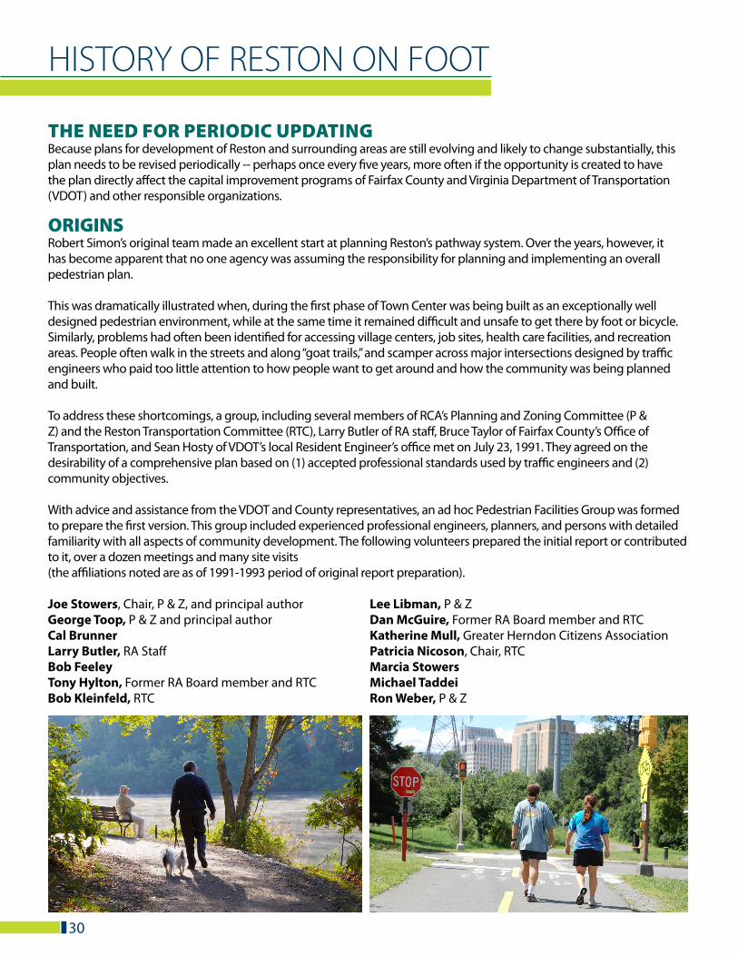
ORIGINSRobert Simon’s original team made an excellent start at planning Reston’s pathway system. Over the years, however, it has become apparent that no one agency was assuming the responsibility for planning and implementing an overall pedestrian plan.
This was dramatically illustrated when, during the first phase of Town Center was being built as an exceptionally well designed pedestrian environment, while at the same time it remained difficult and unsafe to get there by foot or bicycle. Similarly, problems had often been identified for accessing village centers, job sites, health care facilities, and recreation areas. People often walk in the streets and along “goat trails,” and scamper across major intersections designed by traffic engineers who paid too little attention to how people want to get around and how the community was being planned and built.
To address these shortcomings, a group, including several members of RCA’s Planning and Zoning Committee (P & Z) and the Reston Transportation Committee (RTC), Larry Butler of RA staff, Bruce Taylor of Fairfax County’s Office of Transportation, and Sean Hosty of VDOT’s local Resident Engineer’s office met on July 23, 1991. They agreed on the desirability of a comprehensive plan based on (1) accepted professional standards used by traffic engineers and (2) community objectives.
With advice and assistance from the VDOT and County representatives, an ad hoc Pedestrian Facilities Group was formed to prepare the first version. This group included experienced professional engineers, planners, and persons with detailed familiarity with all aspects of community development. The following volunteers prepared the initial report or contributed to it, over a dozen meetings and many site visits (the affiliations noted are as of 1991-1993 period of original report preparation).
Joe Stowers, Chair, P & Z, and principal authorGeorge Toop, P & Z and principal author Cal Brunner Larry Butler, RA Staff Bob Feeley Tony Hylton, Former RA Board member and RTC Bob Kleinfeld, RTC
Lee Libman, P & Z Dan McGuire, Former RA Board member and RTC Katherine Mull, Greater Herndon Citizens Association Patricia Nicoson, Chair, RTC Marcia Stowers Michael Taddei Ron Weber, P & Z
30
1994 UPDATEA 1993 recreation survey by the Reston Association confirmed what RA staff had thought for a number of years: that the pathway system in Reston is by far the most popular recreational amenity in this community. In fact, nearly 85% of the population use the pathways on a regular basis, and nearly 70% use the pathways as often as four to five times per week! This is not too surprising, considering the pathways and sidewalks interlace the roadway and open space network, making it possible to get to almost anywhere in Reston without going on a road.
Because no one organization was totally responsible for the pathways in Reston, there had been a severe lack of communication, coordination, and implementation of needed improvements. The multiple players included the developer, Reston Land Corporation, which was responsible for pathways as part of its land development activities; Fairfax County, which is responsible for the countywide trails system, which represented about 10 of the 60 miles of pathway in Reston; Reston Association, which, at the time, was responsible for about 50 miles of the system; and the Virginia Department of Transportation, which is responsible for intersection improvements and sidewalks in the rights-of-way.
Lee De Cola, Chair Henry Bodson Cal Larson Joe Stowers Rosemary Codding, RA Board Member Larry Butler, RA Staff Roberta Ramsey, RA
1999 UPDATEBetween 1994 and 1999, several major changes occurred in Reston: the North Point area neared completion, other areas were annexed to Reston, the Town Center area development continued, and the Dulles industrial corridor grew rapidly bringing many more jobs and residents to Reston. In short, Reston continued to grow considerably. All of these changes created more traffic on the roads in the area. The increase in traffic naturally leads to an increase in the need to safely move pedestrians through the community.
The Reston Association Facilities Advisory Committee (formerly the Pathways and Facilities Committee) formed a Reston on Foot subcommittee to deal with the complex job of checking the many miles of pathway in Reston and updating these priorities. In some cases, areas that were high priority five years earlier no longer appeared urgent by comparison with Town Center needs, and what were almost “wish list” priorities in 1994 became necessities in 1999.
Reston was divided up according to the Fairfax County Tax Maps. Members of the sub-committee were assigned one or more tax map areas to research and update as necessary. Observers agreed to rank each suggestion as to whether they felt it should have a High, Medium, or Low priority. They were instructed to record any changes in an intersection since the last update as well as any new improvements that they felt should be included. After all the maps were walked, and recommendations made, participants traded areas, and a second observer checked the area. When the area had been walked twice, the two reviewers met to discuss any discrepancies before presenting their findings to the group.
All recommendations were then lumped together in the appropriate High, Medium, or Low ranking and these were distributed for discussion. The group then met to resolve any differences in opinion of need or ranking. After this was done, a draft set of recommendations was tabulated, by merging the initial three sets of priorities put together by the subcommittee.
31
The Reston Citizens Association’s Transportation Committee, the Planning and Zoning Committee, the RCA Board, and the RA Board, reviewed the draft recommendations and made corrections and revisions. Each of these bodies has endorsed the report and urged the responsible organizations to implement the recommendations as soon as feasible.
Keith Shoemaker, Subcommittee chairJoe Stowers, RCA Transportation Committee ChairMarie Vincent, Facilities Advisory Committee ChairKristina AlcornTodd BirkenruthBrian Davidson, Facilities Advisory CommitteeLee De ColaMaurice FliessKarl Ingebritsen, LINKShirley IngebritsenCal Larson
2008 UPDATEIn 2008, the Reston Association approved a name change for the committee that more accurately reflects its goals and commitment. Newly minted the Pedestrian and Bicycling Advisory Committee (PBAC), the Committee is carrying on important work that began in 1993 and has been done under various committee names.
Summit: In 2007, the Reston Town Center held its first Bicycling and Pedestrian Summit. This event brought together local residents, developers, County staff, and others to discuss needs for bicyclists and pedestrians in the Town Center. The PBAC has been working to make this an annual event—the Hunter Mill Pedestrian and Bicycling Summit—co-sponsored by RA, RTCA, and Supervisor Hudgins’ office. This event will allow us to both reassess, on an ongoing basis, needs of pedestrians and bicyclists in Reston, and also develop a coalition of community partners (such as businesses, County staff, employees, residents) who will work toward implementing improvements.
Metrorail Access: As part of the preparation for the Dulles Metrorail project, the Reston Metrorail Access Group (RMAG) formed to address issues related to getting to and from the proposed Reston stations. Several PBAC committee members attended meetings of this group and actively contributed.
The final report that was submitted to the Fairfax County Board of Supervisors is a thorough and professional assessment that takes into account the importance of bicycling and walking as a transportation mode to access the stations. The Committee heartily endorses the recommendations made in this study, and wishes to underscore a point in the introduction, which is that the recommended pedestrian and bicycling accommodations would be a welcome and necessary addition to the transportation infrastructure in Reston:
“Many of the elements in the plan will benefit residents and employees of Reston regardless of the existence of Metrorail stations and should be considered for implementation on their own merits.”
(Wiehle Avenue/Reston Parkway Station Access Management Plans, Final Report, April 15, 2008, Submitted to Fairfax County, VA by Vanasse Hangen Brustlin, Inc. On-line at: http://www.fairfaxcounty.gov/fcdot/sam_meetings.htm)
Nicole Mogul, ChairCheryl Beamer, Board liaisonMary Ellen Craig, Committee memberStan Gowin, Committee memberBrian Murphy, Reston Associationm (RA) staff liaisonKate Hoffman, Committee member
Kathryn Martin, Reston 2000 Transportation CommitteeMike Martin, Hunter Mill Representative, Fairfax County Trails CommissionBrian Murphy, RA StaffSarah PeasleyWendy Shoemaker, Facilities Advisory CommitteeLeslie Stanfield, Reston RunnersMarcia StowersTom Voeller, Former President of the Reston RunnersJerry Waters, Facilities Advisory CommitteeBruce Wright
Joe Leighton, RA Board memberLuciano Mijares, RA staff Bill Packard, Committee memberDoug Pew, Committee memberJoe Stowers, Committee memberJerry Waters, Committee member
32