Embed Size (px)
Citation preview

Review of Construction and Development Control in Bushfire Prone Areas
Office of Security and Emergency Management Department of Premier and Cabinet 2 August 2010
Department of Premier and Cabinet

2 | P a g e
Contents
1. Executive Summary .......................................................................................................................... 3
2. Recommendations ............................................................................................................................ 4
3. Background and Context ................................................................................................................ 7
Bushfire Mitigation through Development Design ........................................................................ 7
Building Construction Standards ................................................................................................. 10
Land Use Planning ........................................................................................................................... 12
4. Consistent and Comprehensive Standards for Tasmania ...................................................... 14
Defining a Bushfire Prone Area in Tasmania ................................................................................. 14
Mapping Bushfire Prone Areas ......................................................................................................... 17
Aligning Land Use Planning and the Building Code ..................................................................... 19
Design of Subdivisions ................................................................................................................... 19
Setting Appropriate Separation Distances ................................................................................ 20
Standards for the Construction of Buildings ............................................................................ 21
Measures Ancillary to Construction – Water Availability and Access ............................... 21
5. Application of Australian Standard AS3959 .............................................................................. 22
6. Draft Planning Directive ................................................................................................................ 27
Scope of the draft Planning Directive ........................................................................................ 27
Vulnerable and Hazardous Uses in Bushfire-Prone Areas .................................................... 30
Hazard Management Areas .......................................................................................................... 30
7. Regulation under the Building Act 2000 .................................................................................... 37
Building Regulations 2004 .................................................................................................................. 37
Building Code of Australia ................................................................................................................ 37
8. Accreditation of Bushfire Risk Assessors.................................................................................. 39
Statutory Foundation for the Accreditation Process .................................................................. 40
Amendments to Land Use Planning and Approvals Act 1993 .............................................. 41
Amendments to the Fire Service Act 1979 .............................................................................. 42
9. Impact of Proposed Schedule and Definition ........................................................................... 44
10. Other Issues that Arose During Review................................................................................ 47
3 | P a g e
1. Executive Summary
In light of the devastation and tragedy of the 2009 Victorian Bushfires, the Hon David Bartlett MP, Premier of Tasmania, requested the Department of Premier and Cabinet to consult with relevant Agencies, Local Government and Councils to make recommendations on appropriate controls for the construction of buildings and development in bushfire prone areas. This report outlines the results of this review.
The control of construction in bushfire prone areas in Tasmania requires a number of core components:
• A definition of a ‘bushfire prone area’ that can be sensibly applied in the Tasmanian context and directs attention towards areas of high bushfire risk;
• A clear set of guidelines within which planning authorities can consider development and use in bushfire prone areas;
• Established standards for construction;
• Adequate resources to support the preparation and assessment of bushfire mitigation plans as relevant to development and use.
The above key elements are delivered in a series of recommendations that promote the adoption of comprehensive arrangements that include clearly defined standards for construction, water availability and access through appropriate controls under the Building Act 2000 and Land Use Planning and Approvals Act 1993 and a proposed framework for the accreditation of professionals in the development community to prepare and accredit plans as suitable in terms of bushfire risk mitigation. Chapter 2 of the report provides a list of recommendations.
Considering bushfire risk in future use and development in Tasmania is critical to increasing the resilience of the Tasmania community and the capacity of individuals, families and communities to protect themselves and others during an extreme bushfire event. These measures must, however, by complemented by ongoing efforts to assist everyone living in bushfire prone areas to understand the risks inherent with the environment within which they live and to take action to manage those risks.

4 | P a g e
2. Recommendations
Recommendation 1: Legislative Framework
1.0 That subdivision, use and construction of building in Bushfire Prone Areas be controlled through the application of appropriate measures under both the Building Act 2000 and the Land Use Planning and Approvals Act 1993 (see page 9).
Recommendation 2: Definition of Bushfire Prone Areas
2.1 The following definition of ‘bushfire prone area’ should be adopted as the standard definition in the draft Standard Schedule to be referred to the Resource Planning and Development Commission for consideration:
Bushfire Prone Area means an area of land which is subject, or likely to be subject to bushfires being any area of land within 100m of a contiguous area of vegetation of greater than 1 hectare (10,000m2).
A bushfire prone area does not include land over 20 metres from a strip of vegetation less than 20m in width regardless of length.
Areas of vegetation separated by less than 20m are to be considered as a contiguous area of vegetation for the purposes of defining a Bushfire Prone Area.
Vegetation for the purpose of the definition of bushfire-prone area, means any vegetation classified under AS 3959 – 2009 Construction of buildings in bushfire-prone areas, but does not include:
(i) non-vegetated areas, such as waterways, roads, footpaths, buildings and rocky outcrops; or
(ii) low threat vegetation, including maintained lawns, golf courses, maintained public reserves and parklands, botanical gardens, vineyards, orchards, cultivated ornamental gardens, commercial nurseries, nature strips, windbreaks and managed agricultural land other than plantation forestry; or
(iii) grasslands other than tussock moorland. Tussock moorland is defined as vegetation types dominated by Buttongrass (Gymnoschoenus sphaerocephalus).

5 | P a g e
Recommendation 3: Mapping of Bushfire Prone Areas
3.0 That the State produce a state-wide map of bushfire prone areas based on existing data-holdings and, within two years, work with relevant planning authorities to confirm the accuracy of maps in priority areas based on significant bushfire risk or significant development demand.
Recommendation 4: Draft Bushfire Schedule
4.1 Subject to the successful amendments to the Land Use Planning and Approvals Act 1993 and Fire Service Act 1979 (see recommendation 6.2 and 6.3), that Attachment 1 be lodged with the Tasmanian Planning Commission for consideration as a Planning Directive.
4.2 That the Tasmania Fire Service develop, in consultation with industry and in parallel to the consideration and introduction of the Standard Schedule, guidelines for the application of discretion to be applied for the imposition of relevant standards to existing properties associated with a development application for an alteration or renovation.
Recommendation 5: Regulation under the Building Act 2000
5.1 Subject to the consideration of the Tasmanian Planning Commission of the draft Planning Directive (see recommendation 2), that Part 2 (Restrictions on Buildings) of the Building Regulations 2004 be amended to include the definition of bushfire prone area1
5.2 That an addition to the Tasmanian Appendix of the BCA Performance Requirements and Deemed to Satisfy provisions be made to prescribe the requirement for adequate water support to defend Class 1, 2 and 3 buildings from fire in bushfire prone areas.
.
5.3 That an addition to the Tasmanian Appendix of the BCA Performance Requirements and Deemed to Satisfy provisions be made to prescribe the requirement for access road construction standards in bushfire prone areas.
Recommendation 6: Industry Accreditation
6.1 That it is noted that the Tasmania Fire Service will commence the process of accrediting industry members for preparing bushfire mitigation plans in parallel with the consideration of the Tasmanian Planning Commission to ensure that there is adequate capacity within industry when the Standard Bushfire Schedule is adopted.
6.2 That the Land Use Planning and Approvals Act 1993 be amended to:
• make it unnecessary for a planning authority to assess a plan approved by an accredited person; and
1 Any proposed change to the Building Regulations 2004 will require recommendation from the Building Regulation Advisory Committee.

6 | P a g e
• indemnify the planning authority from any liability for loss of life or property caused by a fire if the measures approved by an accredited person were later found to be inadequate.
6.3 That Fire Service Act 1979 is amended to provide clear authority for issuing permits to assess Bushfire Hazard Management Plans for the purposes of:
• Certifying that there is insufficient increase in risk from bushfires associated with an development application to warrant any specific bushfire measures; and
• Certifying that a development application incorporates sufficient hazard management areas, access and other fire protection measures to provide adequate bushfire management.

7 | P a g e
3. Background and Context
On 15 March 2009 the, Hon David Bartlett MHA, Premier of Tasmania, announced that he had requested that the Department of Premier and Cabinet provide advice on a package of measures to ensure that the construction of houses in Tasmania was appropriate having regard to the risk from bushfires. The three main reforms that were to be considered were:
1. An appropriate definition of “bushfire prone areas” or a process for defining “bushfire prone areas” for the purposes of applying relevant parts of AS3959-1999 Australian Standard for the Construction of building in bushfire-prone areas or subsequent versions of the Standard in Tasmania through the Building Act 2000;
2. An appropriate draft Standard Bushfire Schedule that can be referred to the Tasmanian Planning Commission for consideration as a new Planning Directive; and
3. Advice on strategies to ensure that development applications for building in “bushfire prone area” can be considered and approved in a reasonable period.
In developing the advice, the Department was to hold urgent consultations with Local Government and relevant industry stakeholders.
This Report outlines the outcomes of these consultations and the recommended approach for enhancing the construction of buildings and increasing the safety of the community in bushfire prone areas.
The review was led by Mr Mathew Healey, Manager, Office of Security and Emergency Management, Department of Premier and Cabinet, with significant Agency-based support from the following reference group members:
• Mr Mark Chladil, Fire Management Planning Office Tasmania Fire Service;
• Mr Brian Risby, Assistant State Planning Adviser, Tasmanian Planning Commission;
• Mr Graeme Hunt, Manager, Building Standards and Regulation, Workplace Standards Tasmania.
Bushfire Mitigation through Development Design
The most effective strategy for enhancing the capacity to defend properties during a bushfire is to ensure that bushfire risk is considered during the subdivision of land and in the construction design process. This ensures that the building design and placement appropriately balances the use of land with the need to protect life and property during bushfires.
Issues that should be considered at either the subdivision or building stage include:
8 | P a g e
• Building design - to avoid (or make easily defendable) areas that could ignite in a bushfire such as cavities that allow for the build-up of hot embers;
• Use of appropriate construction materials to assist in defending the property during a bushfire and to avoid spontaneous combustion due to the radiant heat of bushfires;
• Appropriate separation of buildings and properties from bushfire prone vegetation – the use of cleared areas around a property is critical to reduce the level of radiant heat associated with bushfires and to provide a working space between property and bushfire prone vegetation;
• Adequate water supply to defend properties during a bushfire; and
• Appropriate access and egress for occupants, fire-fighting equipment and others during a bushfire.
In Tasmania, there are two regulatory frameworks relevant to ensuring that development is appropriate having regard to bushfire risk: the Building Act 2000 (which controls standards for building) and the Land Use Planning and Approvals Act 1993 (which provides the framework for promoting sustainable development through the land use planning process).
The objectives of the Building Act 2000 and the Land Use Planning and Approvals Act 1993 are inter-related and need to be considered in advance of further discussion on the creation of an appropriate state-wide framework for the control of development in bushfire prone areas.
The Building Act 2000 is “...an Act to regulate the construction and maintenance of buildings and building and plumbing matters and to provide for permits, enforcement matters and resolution of disputes”. The Building Act 2000 identifies the Building Code of Australia (BCA) as the required standard for the construction of buildings and building works.
Some views were expressed during the review that the control of development in bushfire-prone areas could be managed through the provisions of the Building Act 2000 without reference to the relevant processes established under the Land Use Planning and Approvals Act 1993. It was reasoned that AS3959-2009 Construction of buildings in bushfire-prone areas outlines a nationally agreed framework for the assessment of bushfire risk and construction standards that reduces the risk from bushfires to within acceptable levels.
The objectives of the Building Act 2000 include; “to establish, maintain and improve standards for the construction and maintenance of sustainably designed buildings”. The Act, through reference to the BCA, applies nationally agreed standards for safety, health, amenity and sustainability for buildings. The Act does not, however, impose general obligations on contractors to ensure that a building does not increase the risk of loss of life and property for the owner or the community arising from external factors such as bushfires.

9 | P a g e
The Act requires that all works comply with the requirements of the BCA. The BCA requires that all Class 1, 2 and 3 buildings in designated bushfire prone areas are designed and constructed to reduce the risk of ignition from a bushfire while the fire front passes and AS 3959-2009 Construction of buildings in bushfire-prone areas prescribes ‘Deemed to Satisfy’ standards that support compliance with the BCA.
The standard (AS 3959-2009) outlines a useful methodology for assessing the risk posed by bushfire for any given property and details construction standards considered appropriate to protect the property from a passing fire front. This Standard does not, however, seek to guide mitigation for all risks that may arise. Indeed, the foreword of the Standard notes that “...improving the design of and construction of buildings to minimise damage from the effects of bushfire is but one of several measures available to property owners and occupiers to address damage during bushfire...other measures of mitigating damage from bushfire fall within the areas of planning, subdivisions, siting, landscaping and maintenance”2
Therefore, whilst the BCA and the standard provide useful, nationally agreed guidance on the assessment of bushfire risk and how that risk may influence construction standards, it is necessary to look more broadly at appropriate risk mitigation strategies to ensure that development in bushfire prone areas incorporates appropriate risk management strategies for both the property and the community.
.
The Land Use Planning and Approvals Act 1993 is “...an Act to make provision for land use planning and approvals”. The Act imposes an obligation on “... any person on whom a function is imposed or a power is conferred under this Act to perform the function or exercise the power in such a manner as to further the objectives set out in Schedule 1”. Part 2 of the Schedule provides that an objective of the planning process established by the Act is “...to secure a pleasant, efficient and safe
The primary mechanism under which the objectives of the Act are delivered is through planning schemes which, amongst other things, “...may make any provision which relates to the use, development, protection or conservation of any land in the area”. Planning schemes may also regulate or prohibit the use or development of any land.
working, living and recreational environment for all Tasmanians and visitors to Tasmania”.
In securing a “...safe working, living and recreational environment”, planning schemes should ensure that development in bushfire prone areas does not give rise to unreasonable risk for the landowners and
2 AS 3959-2009 Construction of buildings in bushfire-prone areas, page 7.
the surrounding community. In other words, a planning authority must balance the desires of the individual with the needs of the municipality in terms of furthering the objectives of the Act. In the context of this review, this issue arises most clearly in consideration of the need for workable space surrounding a property during a bushfire. This space is essential not only to protect a property and its occupants, but also to ensure that fire fighters can get access to work in advance of a fire front to protect the community from impacts of the fire.

10 | P a g e
Workable space is required for fire-fighters to prepare for or combat the fire-front, for the safe movement of, or evacuation of people during a bushfire and for access by others engaged to protect lives and property during a bushfire.
It is the advice of the Tasmanian Fire Service that this ‘workable space’ was one of the reasons behind including in the foreword of AS3595-2009 that “...there may be circumstances advised by authorities having jurisdiction that building in a particular bushfire location is either not recommended or not permitted based on unrealistic risk exposures”.
On balance, it is considered both appropriate and necessary for the control of development in bushfire prone areas to be managed through relevant provisions of both the Building Act 2000 and the Land Use Planning and Approvals Act 1993. The Building Act 2000 should be used to reference the requirements of the BCA (and draw down the relevant provisions of AS3959-2009 Construction of buildings in bushfire-prone areas) and the relevant provisions of the Land Use Planning and Approvals Act 1993 should be used to ensure that development does not give rise to unacceptable risks for loss of life and property at each of the settlement planning, subdivision and development stages.
Recommendation 1: That the development and construction of building in Bushfire Prone Areas be controlled through the application of appropriate measures under both the Building Act 2000 and the Land Use Planning and Approvals Act 1993.
The Building Act 2000 requires that all building work, as well as the use and maintenance of buildings, is to comply with the BCA.
Building Construction Standards
The BCA requires that all residential Class 1, 2 and 3 buildings constructed in designated bushfire prone areas (BPAs) provide appropriate resistance to bushfires in order to reduce the danger to life and minimise the risk of property loss. The BCA requires that a Class 1, 2 or 33
“...that is constructed in a
building:
designated bushfire prone area must be designed and constructed to reduce the risk of ignition from a bushfire while the fire front passes”.
The performance-based BCA adopts two broad types of building solutions for managing risk:
• Implementing the deemed-to-satisfy (DTS) provisions which are specific construction requirements that are either contained in the BCA or in BCA reference documents
3 Class 1 buildings include a single dwelling or a boarding house, guest house, hostel or the like. Class 2 building is a building containing 2 or more sole-occupancy units each being a separate dwelling. A Class 3 building is a residential building, other than a building of Class 1 or 2, which is a common place of long term or transient living for a number of unrelated persons.

11 | P a g e
such as Australian Standards. For bushfire risk reduction, DTS compliance is achieved by adherence to the Australian Standard for Construction in Bushfire Prone Areas (AS3959-2009 from 1 May 2009); or
• Formulating an alternative solution that can be shown to be at least equivalent to the DTS provisions or otherwise demonstrate that it meets the performance requirements of the Code.
AS3959-2009 Construction in bushfire-prone areas includes the agreed methodology for determining likely ‘Bushfire Attack Levels’ (BALs) for individual properties and outlines acceptable construction requirements having regard to the threat posed by bushfires within the BAL. The method outlined in the Australian Standard AS3959-2009 includes:
• consideration of a nominal Fire Danger Indices (FDI) for jurisdictions/regions; • a guide to classifying surrounding vegetation types; • methods for assessing the distance of the site from the vegetation; and • a guide to considering the effective slope under the classified vegetation and its
impact on bushfire risk.
The Standard outlines appropriate construction methods for the following BALs:
• BAL-LOW – insufficient risk to require any additional protection against bushfire attacks;
• BAL-12.5 – buildings likely to be exposed to ember attack during a bushfire. Expected heat intensity would ignite timber after a long time with a flame;
• BAL-19 - buildings likely to be exposed to increasing levels of ember attack and burning debris ignited by windborne embers together with increasing heat flux. Expected heat intensity would ignite timber after a long time with a flame;
• BAL-29 – buildings likely to be exposed to increasing levels of ember attack and burning debris ignited by windborne embers together with increasing heat flux. Expected heat intensity would ignite timber after a long time without a flame;
• BAL-40 – buildings likely to be exposed to increasing levels of ember attack and burning debris ignited by windborne embers together with increasing heat flux with the increased likelihood of exposure to flames. Expected heat intensity is almost to the point where cotton would ignite after 5 seconds; and
• BAL-FZ (Flame Zone) – buildings likely to be directly exposed to flames from fire front in addition to heat flux and ember attack. Expected heat intensity where timber would self-ignite.
The Australasian Fire and Emergency Service Authorities Council (AFAC) does not support the current Australian Standard for a number of reasons. The most significant issue of concern for AFAC was the inclusion of the construction standards for the ‘Flame Zone’. It

12 | P a g e
is the strong view of AFAC that the risks associated with building in ‘Flame Zone’ conditions are intolerable and that it should be prohibited in all circumstances.
The Australian Building Codes Board, on the other hand, has endorsed the inclusion of AS3959 – 2009 in the 1 May 2010 Building Code of Australia. The Board is cognisant of AFAC’s views but has commissioned research which concludes that the 2009 version of the Standard improves the level of fire safety for residential buildings in bushfire prone areas compared to the previous version.
In order to directly implement the requirements for the construction of Class 1, 2 and 3 buildings outlined in the BCA, a jurisdiction must designate ‘bushfire prone areas’ under legislation.
Tasmania has not, to date, declared bushfire-prone areas for the purposes of the BCA. The Building Act 2000 therefore, does not currently require that the construction of Class 1, 2 and 3 buildings in areas susceptible to bushfires be built to the standard required under the BCA.
The Australian Standard has been adopted in some form, and with varying levels of coverage, in all jurisdictions, with the exception of the Tasmania and Northern Territory.
The Tasmania Fire Service and relevant State Agencies have been promoting consideration of bushfire mitigation measures in municipal Planning Schemes. To support these efforts, the Tasmania Fire Service published Guidelines for Development in Bushfire Prone Areas of Tasmania 2005 to assist councils to define bushfire-prone areas and to require bushfire mitigation measures to be considered as part of the development approvals process. The guidelines do not mandate building construction methods but refer to the Australian Standard (AS3959) as best practice.
Land Use Planning
Currently, of the 38 planning schemes4
• Ten include a dedicated bushfire schedule that considers issues such as vegetation management, road access and water supply. All of the schedules rely on a definition of bushfire-prone areas, based on the Guidelines for Development in Bushfire Prone Areas of Tasmania 2005;
in force in Tasmania:
• Three other planning schemes incorporate the definition of bushfire-prone areas based on the Guidelines for Development in Bushfire Prone Areas of Tasmania 2005 but do not include broad reference to issues such as vegetation management, road access and water supply;
4 Not all planning schemes were reviewed in detail. A number of planning schemes cover small areas or cover areas where bushfires are unlikely to represent a significant risk (eg. Sullivans Cove).
13 | P a g e
• Seven planning schemes include a ‘fire hazard area’ within which use and development is discretionary;
• Six planning schemes contain general references to a requirement to consider bushfire risk in development applications;
• One scheme requires consideration only of existing fire management plans; and
• At least one planning scheme covering a reasonable area contains no reference to bushfire risk.
There have been concerns raised by industry and the community with regard to the lack of consistency associated with the application of bushfire mitigation measures across planning schemes and municipalities.
Planning Directive No.1 introduced a standard Planning Scheme Template in December 2003. So far only two planning schemes in Template format are in effect but others are being prepared. The current regional planning initiatives are aimed at covering the State with consistent and contemporary planning schemes over the next few years. Part of this project involves reviewing and expanding the Template and the preparation of a suite of standard schedules, including a bushfire schedule.
A particular complexity that arose during the consideration of the issues during the review was associated with the range of approaches with exemptions to planning schemes across the State.
Exemptions are used to identify development and use that does not require a planning permit. For many Planning Schemes, exemptions are provided for minor renovations and development and the exemption is largely absolute (no consideration is required by Council). In others, however, exemptions may include more substantial development (such as single houses) but the exemption is limited to development that complies with particular standards within the scheme.
The interplay between the standards prescribed in the proposed planning directive and the approach to ‘exemptions’ in existing planning schemes required careful consideration to ensure that an appropriate balance was struck between avoiding unreasonable imposition on minor renovations and applying appropriate standards to large-scale development. This issue is discussed further in Chapter 6.
14 | P a g e
4. Consistent and Comprehensive Standards for Tasmania
Defining a Bushfire Prone Area in Tasmania
The primary, and most critical, issue for the State in progressing standards for building and subdivision in bushfire prone areas is to agree on, and introduce, a mechanism for determining a ‘designated bushfire prone area’. This is important for both implementing the relevant parts of the BCA and for ensuring that there is consistent application of controls through the land use planning system.
There is significant variation across the State with regard to the approach to defining areas subject to risks from bushfires.
Thirteen planning schemes include a clear definition of ‘bushfire-prone area'. A common component of this definition is that the land is within 100m of standing vegetation of at least 1ha in size. There are differences however, in that:
• some schemes exclude grasslands on less than 5 degrees of slope whilst others do not exclude grasslands;
• some define ‘high’ and ‘moderate’ risk by reference to slope of the land;
• at least one planning scheme excludes all vegetation other than trees or scrub that grow to a height of 2 metres or above.
A further seven planning schemes do not include a clear definition of ‘bushfire prone area’ but rather allow the Council to assess that an area is subject to risk from bushfires.
At least one planning scheme defines bushfire risk in terms are areas defined on a map.
AS 3959-2009 Construction of buildings in bushfire-prone areas defines ‘bushfire prone areas’ as “...an area that is subject to, or likely to be subject to, bushfire attack’. This definition is sufficiently broad to allow individual jurisdictions to determine how it is to be applied based on local risk.
There are two options for defining ‘bushfire prone areas’: by reference to the likelihood of bushfire in a region or municipality or by reference to the proximity of an area to bushfire prone vegetation.
Some jurisdictions have taken a regional approach to defining ‘bushfire prone areas”. For example Queensland defined bushfire prone areas to be “... land declared by the Local Government as likely to be subject to bushfires”.
Most native vegetation in Tasmania is ‘bushfire prone’ and the frequency of bushfire activity is relatively well spread across developed areas in the State. It is, therefore, not reasonable or practical to define regions as being either ‘bushfire prone’ or not ‘bushfire prone’.

15 | P a g e
Defining land to be ‘bushfire prone’ by reference to its proximity to bushfire prone vegetation is reasonably practicable and is the approach that is adopted, in practice, in many other jurisdictions.
AS 3595-2009 provides some guidance for defining ‘bushfire prone areas’ by outlining the parameters beyond which construction measures to reduce risks from bushfires are considered no longer necessary (BAL-LOW)5
a. Vegetation of any type that is more than 100m from the site;
. The standard defines BAL-LOW to include areas where the adjacent vegetation is one or a combination of any of the following:
b. Single areas of vegetation less than 1 ha in area and not within 100m of other areas of vegetation being classified;
c. Multiple areas of vegetation less than 0.25 ha in area and not within 20 m of the site, or each other;
d. Strips of vegetation less than 20 m in width regardless of length and not within 20 m of the site or each other, or other areas of vegetation being classified;
e. Non-vegetated areas, including waterways, roads, footpaths, building and rocky outcrops;
f. Low threat vegetation, including managed grassland, maintained lawns, golf courses. Maintained public reserves and parklands, botanical gardens, vineyards, orchards, cultivated ornamental gardens, commercial nurseries, nature strips and wind breaks.
The purpose of the definition of BAL-LOW and the definition of ‘bushfire-prone area’ are not entirely congruous. The value of aligning the definitions, however, is that it minimises the requirement for individuals, designers, builder, building surveyors and planning authorities to undertake a formal assessment of bushfire risk where the assessment is unlikely to recommend any additional measures required for bushfire risk mitigation. This approach, therefore, represents the least cost option for developers, the community and Government.
The appropriate definition of bushfire prone area has been considered by all stakeholders during the review. Whilst the wording of the definition has evolved throughout the review, the intent has remained relatively unchanged.
5 AS3959-2009 Construction in bushfire-prone areas, section 2.2.3.2, page 15

16 | P a g e
The following is considered to represent an appropriate definition:
Bushfire-prone area means an area of land which is subject, or likely to be subject to bushfires being any area of land within 100m of a contiguous area of vegetation of greater than 1 hectare (10,000m2).
A bushfire-prone area does not include land over 20 metres from a strip of vegetation less than 20m in width regardless of length.
Areas of vegetation separated by less than 20m are to be considered as a contiguous area of vegetation for the purposes of defining a bushfire-prone area.
Vegetation for the purpose of the definition of bushfire-prone area means any vegetation classified under AS 3959 – 2009 Construction of buildings in bushfire-prone areas, but does not include:
(i) non-vegetated areas, such as waterways, roads, footpaths, buildings and rocky outcrops; or
(ii) low threat vegetation, including maintained lawns, golf courses, maintained public reserves and parklands, botanical gardens, vineyards, orchards, cultivated ornamental gardens, commercial nurseries, nature strips, windbreaks and managed agricultural land other than plantation forestry; or
(iii) grasslands other than tussock moorland. Tussock moorland is defined as vegetation types dominated by Buttongrass (Gymnoschoenus sphaerocephalus).
The definition recommended for ‘bushfire-prone areas’ in Tasmania differs from the AS2959 definition of BAL-LOW in that it excludes managed agricultural land other than plantation forestry and grasslands but includes tussock moorland (whether it is managed or not). This change is based on advice from the Tasmania Fire Service regarding the threat posed by vegetation types in Tasmania.
It is important to note that defining a property as being within a ‘bushfire-prone area’ cannot be used as a proxy to defining the risk from bushfires. Rather, the term simply implies that there is sufficient risk-potential in an area to warrant individuals, designers, assessors and planning authorities to consider the bushfire risk during the process of subdividing or developing the land. A further assessment of the local conditions will identify any risks associated with bushfires.

17 | P a g e
Recommendation 2.1: The following definition of ‘bushfire-prone area’ should be adopted as the standard definition of ‘bushfire prone area’ in the draft Standard Schedule to be referred to the Tasmanian Planning Commission for consideration:
Bushfire-prone area means an area of land which is subject, or likely to be subject to bushfires being any area of land within 100m of a contiguous area of vegetation of greater than 1 hectare (10,000m2).
A bushfire-prone area does not include land over 20 metres from a strip of vegetation less than 20m in width regardless of length.
Areas of vegetation separated by less than 20m are to be considered as a contiguous area of vegetation for the purposes of defining a bushfire-prone area.
Vegetation for the purpose of the definition of bushfire-prone area means any vegetation classified under AS 3959 – 2009 Construction of buildings in bushfire-prone areas, but does not include:
(i) non-vegetated areas, such as waterways, roads, footpaths, buildings and rocky outcrops; or
(ii) low threat vegetation, including maintained lawns, golf courses, maintained public reserves and parklands, botanical gardens, vineyards, orchards, cultivated ornamental gardens, commercial nurseries, nature strips, windbreaks and managed agricultural land other than plantation forestry; or
(iii) grasslands other than tussock moorland. Tussock moorland is defined as vegetation types dominated by Buttongrass (Gymnoschoenus sphaerocephalus).
Recommendation 2.2: Once considered by the Tasmanian Planning Commission and issued by the Minister as a Planning Directive, the definition of a ‘bushfire-prone area’ adopted in the Standard Schedule should be included in the Building Regulations 2004 for the purposes of implementing the requirements of the Building Code of Australia.
Mapping Bushfire Prone Areas
Mapping bushfire prone areas is a useful tool for providing confidence in the scope of regulatory controls and certainty for developers. Maps of ‘bushfire-prone areas’ have been produced in area such as Launceston, Hobart and Glenorchy as a tool to support the application of relevant provisions within a planning scheme. The Launceston Planning Scheme 1996 defines bushfire prone area in terms of areas identified on a map.
There have been two conflicting views expressed on the value of mapping ‘bushfire-prone areas’. The view of industry is that a map of ‘bushfire-prone areas’ should be provided prior to the definition being applied through planning schemes or within a reasonable period following its introduction. The view expressed by many Councils, however, is that mapping

18 | P a g e
should only be completed at the discretion of Councils and that it should guide (not bind) the application of the definition.
The value of mapping ‘bushfire-prone areas’ is supported in principle, particularly for areas where there are likely to be a large number of applications for development. Development on the urban fringe is likely to particularly benefit from a clear map of the areas considered to be bushfire prone.
Mapping of bushfire prone areas can be resource intensive, particularly in areas where current mapping of vegetation is inaccurate due to clearing or revegetation activities. There are likely to be many regions within the State where an investment in high-confidence mapping of bushfire-prone areas is unlikely to be warranted due to the low rate of development applications.
Many larger councils retain an in-house mapping capability that could be used to develop maps of bushfire prone areas based on the recommended definition. Most small to medium sized councils do not have the resources to undertake such mapping and would benefit significantly from access to State-level expertise in mapping.
There are complications with the legal status of maps identifying bushfire prone areas if they are not incorporated into planning schemes. By incorporating maps into planning schemes, the process for updating the map will be subject to the normal planning scheme amendment process and can be lengthy. Any reluctance to update the map frequently (due to the formality of the process) could lead to circumstances where the mapped ‘bushfire prone area’ no longer reflects the real situation on the ground.
On balance, it is recommended that the State Government coordinate the development of a ‘first pass’ map of bushfire prone areas as a tool for planning authorities and for communicating with industry and the community. This map could be produced using current vegetation data (Tasveg 2.0). The state-wide map should be confirmed in consultation with relevant Councils for those areas considered to be a priority based on either significant bushfire risk, or significant development demand. For municipalities that have already mapped bushfire prone areas, existing maps should be confirmed against the new definition and adopted as part of the State-wide bushfire prone areas map. The process of developing a state-wide map and confirming the details in priority areas should be completed within two years.
Incorporating relevant components of the State-wide map of bushfire prone areas into the relevant planning scheme should be progressed at the discretion of the relevant planning authority.
Recommendation 3: That the State produce a state-wide map of bushfire prone areas based on existing data-holdings and, within two years, work with relevant planning authorities to confirm the accuracy of maps in priority areas based on significant bushfire risk or significant development demand.

19 | P a g e
Aligning Land Use Planning and the Building Code
Consultation with industry, local government and State Agencies has identified a wide range of issues that have required detailed consideration. Possibly the most significant of these issues has been a divergence of views regarding the separation of the arrangements for the control of construction activity through the Building Act 2000 and the control of land use through the Land Use Planning and Approvals Act 1993.
For the purposes of outlining the issues and presenting a suggested way forward, the application of bushfire mitigation measures through planning controls is separated into the following five areas:
• Design of subdivisions (including new land titles);
• Setting appropriate buffer zones;
• Standards for the construction of habitable buildings;
• Mitigation measures ancillary to the construction of habitable buildings; and
• Managing off-site buffer zones.
Once a subdivision has been approved, it can become very difficult to ‘retro-fit’ suitable bushfire risk mitigation measures based on consideration of development applications submitted on a title-by-title basis. At the subdivision stage, planning authorities can ensure that the area to be developed is suitable having regard to:
Design of Subdivisions
• Adequate access and egress for fire-fighters and others;
• Adequate separation from bushfire prone vegetation on a whole subdivision basis and/or a demonstrated capacity to incorporate adequate separation at the individual title level;
• Capacity to satisfy bushfire risk mitigation measures having regard to other planning controls (eg. native vegetation, threatened species, prime agricultural land); and
• Access to adequate water and road infrastructure.
These issues should be managed through the existing processes managed by planning authorities operating under the Land Use Planning and Approvals Act 1993.
It is recognised that an approval to subdivide land cannot always bind a future owner to build in accordance with the intentions of the developer that created the title. Therefore, a subdivider cannot guarantee at the subdivision stage that a future building will not create unacceptable risks to individuals and the community in terms of loss of life or property from bushfires. A subdivider can, however, demonstrate that there is a reasonable solution for building on all new titles having regard to the risk from bushfires. Any future development could either comply with the solution envisaged at the subdivision stage or seek a further assessment of an alternate solution.
20 | P a g e
It is noted that large subdivisions could incorporate buffer-zones of sufficient scale to remove some or all titles within the subdivision from the definition of ‘bushfire prone area’ thereby removing any requirement for further assessment.
This issue is considered further in chapter six - ‘Draft Planning Directive’.
Setting appropriate separation distances is critical to the standards that are to be applied to construction in bushfire prone areas. As noted previously, the Bushfire Attack Level (BAL) is calculated using an assessment of the vegetation type, the fire danger index, the slope of the property and the available separation distance. With the exception of the separation distance, these factors are largely intrinsic to the location of the property and difficult to influence. The separation distances can, however, be modified by reducing the building envelope, changing the placement of the building on the property or through clearing vegetation (subject to regulation).
Setting Appropriate Separation Distances
Separating buildings from bushfire prone vegetation serves two purposes:
• it reduces the ember, radiant heat and flame attack level on the building; and
• it provides a working space for fire-fighters and other emergency services personnel and assists with evacuation if necessary.
AS3959-2009 Construction in bushfire-prone areas is primarily designed to assist individuals to manage the risks associated with the ember, radiant heat and flame attack level. The Standard provides a framework for balancing these risks with the standard of construction required; the lower the separation from bushfire prone vegetation, the higher the standard required for design and materials. This is a very important component of reducing risk in bushfire prone areas and should continue to be managed through the Building Act 2000.
As noted previously, AS3959-2009 Construction in bushfire-prone areas does not seek to provide any guidance on the appropriate provisioning of working space for fire fighting or evacuation from the property. It is noted in the Standard that “...there may be circumstances advised by authorities having jurisdiction that building in a particular bushfire location is either not recommended or not permitted based on unrealistic risk exposures”.
Planning schemes are the appropriate mechanism to control development to avoid inappropriate impacts on the community and to ensure that a safe working, living and recreational environment is maintained. It is therefore recommended that any requirement for separation distances be imposed through both a requirement to comply with the AS3959-2009 and through consideration in planning schemes to ensure that development meets the sustainable development objectives on the Land Use Planning and Approval Act 1993.
Any requirements imposed on development through planning schemes should be consistent with the requirements imposed by the Building Act 2000 and should, as far as is reasonably

21 | P a g e
practicable, avoid circumstances where similar issues are being considered by separate decision-makers operating under different legislation.
These issues are discussed further in the section six - ‘Draft Planning Directive.
The long title of the Building Act 2000 includes to “... regulate the construction and maintenance of buildings and building and plumbing matters and to provide for permits, enforcement matters and resolution of disputes”. As noted previously, the Building Act 2000 mandates compliance with the BCA, which requires that building in bushfire prone areas meets the standards outlined in AS3959-2009 Construction in bushfire-prone areas.
Standards for the Construction of Buildings
It is clear that the Building Act 2000 is the appropriate head-of-power for setting the required standards for the construction of Class 1, 2 and 3 building in bushfire prone areas. Once an appropriate declaration of “bushfire-prone area” has been made, a demonstration that the appropriate standards have been applied will be required as a precondition of issuing a certificate of likely compliance and a building permit.
Adequate access to water for fire-fighting purposes and adequate access to the property are factors critical to managing bushfire risk. They are also issues that have direct relevance to both planning consideration and appropriate permits issued under the Building Act 2000.
Measures Ancillary to Construction – Water Availability and Access
A view was expressed during the review that the placement of standards for water access and road infrastructure in the Planning Schedule could lead to conflict with requirements prescribed under the Building Code of Australia. It was requested, therefore, that the review identify an approach to align these requirements.
The proposed framework outlined in this report aligns the planning and building requirements by recommending that standards of road and water access be added to the Tasmanian Annex to the Building Code of Australia.
Some concern was raised by Councils that the relationship between controls prescribed under the Building Act 2000 and the Land Use Planning and Approvals Act 1993 was, to some degree, undermined by advice received that a certificate of occupancy could not be withheld under the Building Act 2000 based on non-compliance with conditions prescribed in a permit issued under the Land Use Planning and Approvals Act 1993. This issue was not explored in detail by the review as it was noted that there are alternative mechanisms under the Land Use Planning and Approvals Act 1993 for enforcing conditions of a planning permit. It is also noted that the State Government is currently working with Local Government to enhance the powers available for enforcing permit conditions (see Section 10).

22 | P a g e
5. Application of Australian Standard AS3959
Since the Ash Wednesday fires in 1984, Standards Australia has been developing a national standard for site assessment of bushfire risk and construction methods to meet the identified risk. The first standard (AS3959-1991) prescribed minimal measures to protect properties against burning debris. It was reasoned that the hazard assessments at the time were insufficient to justify the added cost of measures required to protect buildings against radiant heat and flame impingement. It was estimated that the requirements of AS3959-1991 added approximately $937 to the cost of a standard brick veneer entry-level house.
Following the 1994 NSW bushfires, and in light of relevant recommendations of the NSW coroner, the standard was revised (AS3959-1999) to include a site assessment method and varying standards of construction based on the assessed risk.
The Regulatory Impact Statement of AS3959-1999 was released in August 1999. The RIS reasoned that there was little evidence of individuals voluntarily incorporating bushfire protection measures into buildings, with the majority of houses built following the Ash Wednesday fires in 1984 containing no more protection than the ones they replaced.
In line with commonly adopted approaches to risk management, the revised standard AS3959-1999 sought to impose a greater level of protection on sites that could be assessed as having a greater hazard. The revised standard introduced two levels of construction (Medium and High) and broadened the scope of the standard to consider the risks posed by burning debris, radiant heat and flame impingement.
AS3959-1999 was amended in December 2000 to include a third level of construction (Extreme). The introduction of building standards for areas of extreme risks was not supported by the (then) Australasian Fire Authorities Council.
The most recent revision of the standard (AS3959-2009) sought to improve site assessment methodology and introduce a broader range on construction solutions depending on the risks identified. The Australian Building Codes Board notes that, “...to a large extent, the proposed revisions originate from a spate of bushfire incidents in Australia in recent years and insights from research around these”. The Board also notes that the most recent revisions reflect an increased level of awareness in the building industry about the potential impact of climate change on bushfire activity.
AS3959-2009 continued to align the standard with contemporary knowledge about the nature and extent of bushfire risks and the effectiveness of different prevention measures in mitigating those risks. The RIS for this revision reasons that the new standard “...is more likely to effectively deal with bushfire risk because it takes a more scientific approach to the assessment of risks associated with a particular site and aligns construction requirements with the assessed category of bushfire attack risk”.
The new standard incorporated the following features:

23 | P a g e
• A Fire Danger Index (FDI) which allows for different standards of construction to be applied to different regions depending upon the regional fire risk;
• Changes to the way that the slope of the land was assessed and considered; and
• Creation of six Bushfire Attack Levels (BALS) to replace the two-levels of construction in the previous standard.
The Australasian Fire and Emergency Service Authorities Council (AFAC) continued to raise concerns with the inclusion of construction standards within the area subject to extreme risk from bushfires (principally the flame zone or area subject to direct flame impingement during a bushfire).
The RIS for AS3959-2009 included costs estimates for construction based on three types of houses – a three-bedroom, single story house (base house), a large, two-storey house and an elevated-level, four bedroom house (elevated lightweight construction, ELC). The estimated cost increase for construction for houses in bushfire prone areas compared to houses outside of bushfire prone areas is shown in table 1.
Category of bushfire attack
Base House Large Two-Storey
ELC house
BAL-LOW $0 $0 $0
BAL-12.5 $11,535 $14,981 $21,428
BAL-19 $11,535 $14,981 $21,428
BAL-29 $15,471 $17,095 $35,024
BAL-40 $17,107 $19,751 $62,357
BAL-FZ $20,885 $28,905 $76,679
The RIS was not able to directly comment on the total cost/benefit of the standard as its conclusions focussed solely on the comparative costs of the 2009 revisions, compared to the existing costs imposed by AS3959-1999. It reasoned, however, that the proposed standard is likely to lead to a reduction in the costs associated with bushfire events, may stimulate demand for construction of some house types and lead to a reduction in the social disruption costs and adverse economic impacts associated with bushfire events.
There has been an evolution of the standard of bushfire risk mitigation applied through planning schemes in Tasmania and an increased focus on appropriate standards for development in areas at risk from bushfires. Therefore, like the RIS for AS3959-2009, the expected impact of designating bushfire prone areas for the purposes of mandating the Australian Standard should not be considered as an ‘all or nothing’ proposition.
The Tasmania Fire Service’s Guidelines for Development in Bushfire Prone Areas of Tasmania 2005 is currently formally referenced or relied upon by a majority of planning schemes in Tasmania. These guidelines refer to the Australian Standard as best practice in terms of
24 | P a g e
construction in bushfire prone areas and recommends separation distances for properties that would require, or at least strongly encourage where feasible, houses in bushfire prone areas to be sited and built so that the risk is contained to within the lower bushfire attack levels outlined within the Standard (BAL-LOW and BAL-12.5). For building a houses in line with these existing guidelines , AS3959-2009 will impose an additional costs of around $15,400 for a large, two-story property. This is not considered to be a significant cost for the increased protection afforded by the construction standard.
Under the proposed draft Standard Bushfire Schedule, the prescribed acceptable solution of development of Class 1, 2 and 3 buildings in bushfire prone areas is to maintain, at minimum, separation distances prescribed for BAL-29. If accepted, the impact of complying with the acceptable solution for development on existing titles would be a maximum of around $17,100 for a large two-storey house.
The acceptable solution for subdivision in bushfire prone areas provides that a workable solution should be provided on each title for development of Class 1, 2 and 3 properties that maintain, at minimum, separation distances prescribed for BAL 19. If accepted, the impact of complying with the acceptable solution for subdivisions would be a maximum of around $15,000 for a large two-storey house.
A number of stakeholders identified ‘wilderness’ as a legitimate value that is incorporated into commercial operations in Tasmania and that a ‘blind’ application of AS3959-2009 would significantly impact on future growth in the tourism industry. The review agrees that this would not be an appropriate outcome of the control arrangements and that some flexibility is required.
Impact on ‘Wilderness’ Operations
As noted previously, AS3959-2009 is applied through a requirement under the Building Act 2000 that all building work is to comply with the Building Code of Australia (BCA). The BCA includes a performance criterion that “a building that is constructed in a designated bushfire prone area must be designed and constructed to reduce the risk of ignition from a bushfire while the fire front passes”. An acceptable standard to meet this performance criterion is to comply with AS3959-2009.
Circumstances may, arise, however, where a decision is reasonably made that not all habitable buildings within a development application require construction-based protection from ignition as prescribed in AS3959. For example, a wilderness tourism operator may choose to work with the Tasmania Fire Service to identify arrangements that reasonably protect lives through a combination of warning and evacuation processes. This bushfire mitigation plan may also include arrangements to abandon some elements of the property in exchange for developing appropriately constructed and protected buildings that can be used for retreat and refuge in circumstances where evacuation is not possible. This flexible application of bushfire mitigation measures is not accommodated within the BCA alone.

25 | P a g e
Section 218 of the Building Act 2000 provides that “a person may apply to the Building Appeal Board to determine whether any provision of the Building Code of Australia or the Tasmanian Plumbing Code applies or may be modified in respect of any building work or plumbing work that is proposed to be undertaken by the person”. The test for the Appeal Board in determining that that a provision of the BCA be modified for the purposes of the development is that the modification “...is reasonable and not detrimental to the public interest”.
The Building Appeal Board may seek submissions from the Director of Building Control and the relevant Planning Authority and may impose any relevant condition.
Under this provision, a developer that is unable to fully comply with the requirement for all habitable buildings to “...be designed and constructed to reduce the risk of ignition from a bushfire while the fire front passes” could apply to the Appeals Board to determine that the relevant part of the BCA should not apply to some or all of the development. The presence of a bushfire mitigation plan that has been agreed by the Tasmania Fire Service would be a significant component to any consideration of the Board regarding reasonableness and whether it is detrimental to the public interest.
This process is considered adequate to address the likely concerns of the small number of operators that will require habitable buildings to be located in very close proximity to bushfire prone vegetation for the purposes of providing a wilderness experience.
It is noted that, in most areas of the State, any large development in areas at risk from bushfires are currently required to consult with the Tasmania Fire Service during the design stage.
A concern was raised by industry representatives that the application of AS3959-2009 in Tasmania may impact on the demand for locally sourced timber products.
Impact on the Use of Timber
The construction standards required under AS3959-2009 has the following general impact on the use of timber in construction:
BAL-LOW
The standard does not impose restrictions on the use of timber;
BAL 12.5 and BAL-19
The standard does not impose requirements for floors, subfloor supports or external walls more than 400mm from the ground, decks, carports roofs, awnings or similar elements.
For external walls within 400mm of the above elements, bushfire shutters over windows and vehicle access doors are required. If timber is used, the timber must be bushfire-
26 | P a g e
resisting or high-density, which includes Tasmanian Oak (E. obliqua) and Tasmanian Blue Gum (E. globulus).
Fully glazed doors, as well as window and door frames less than 400mm from the ground, decks, carports roofs, awnings or similar elements must be made from timber with a density greater than 650 kg/m3, which includes all major commercial construction timbers in Tasmania (does not include Radiata Pine, Huon Pine or Sassafras).
No standards are prescribed for decking, verandas and the like unless it is within 300mm from glass. Decking, verandas and the like within 300mm of glass must be constructed from bushfire resisting or high-density timber.
BAL-29
Where the subfloor space is not enclosed, the standard requires that most elements be made using bushfire resistant timber, which does not currently include Tasmanian timbers (although further testing of species is underway).
Timber use on external walls, bushfire shutters, window and door frames, vehicle access doors and other elements is also limited to bushfire resisting timber.
BAL-40 – and BAL – FZ
Use of timber is limited to applications that have been tested as being fire resistant.
As note previously, the combination of cost-drivers and the incentives provided by the draft Standard Bushfire Schedule are expected to encourage individuals to seek building solutions that give rise to BAL-LOW, BAL-12.5 or BAL 19 construction standards. Construction in BAL-29 conditions is an acceptable solution for development of Class 1, 2 and 3 buildings, but is not prescribed as an acceptable solution for the creation of new titles intended for Class 1, 2 and 3 buildings. Given that there is limited or no impact on the use of timber in BAL-LOW, BAL-12.5 or BAL 19, the impact on the timber industry in Tasmania is expected to be low. Of particular note, Forest and Wood Products Australia, reasons that:
“While the updated standard modifies how a home is built to address bushfire risk, it still enables designers, builders and home owners to enjoy all the advantages of wood. In all cases, it is still acceptable to build as we always have – with easy, economical and sustainable timber-framed construction - for brick veneer and lightweight cladding exteriors”6
6 Timber Housing in Bushfire Prone Areas, Designing timber-framed and clad houses to meet new building standards. Wood, Naturally Better, July 2009 (www.timber.org.au)
.

27 | P a g e
6. Draft Planning Directive
A draft Planning Directive incorporating a Standard Bushfire Schedule is provided at Attachment 1. The draft Directive represents the outcome of consultation with Government, industry and Local Government stakeholders.
It is proposed that Attachment 1 be lodged with the Tasmanian Planning Commission for consideration as a planning directive. Any use or development that is within its scope will be dealt with under the Directive and not under the existing planning scheme controls (if any). Any provisions of a planning scheme that are beyond the scope of the proposed planning directive (including sections dealing with other issues relating to bushfire mitigation) will continue to operate.
The Directive is drafted as a performance based set of provisions providing an objective, acceptable solution and performance criteria for each issue. Although many current planning schemes are not drafted in this form there are other examples of amendments to planning schemes which do not have the same structure as the original scheme but operate without issue. The standard schedule for telecommunications infrastructure has been operating in every planning scheme in Tasmania for many years, and some planning schemes have introduced residential codes and local area plans which are performance based into traditional planning schemes. Additionally, the proposed Planning Directive will not require amendment of current planning schemes but will operate as a stand alone set of requirements with its own machinery clauses until all current planning schemes are replaced by new schemes based on the Common Key Elements Template through the current regional planning initiatives.
Recommendation 4.1: That Attachment 1 be lodged with the Tasmanian Planning Commission for consideration as a planning directive.
The following sections outline the principles upon which the schedule is built.
There has been some discussion throughout the review regarding the proposed scope of the draft Planning Directive.
Scope of the draft Planning Directive
Many stakeholders, including the Tasmanian Fire Service, are of the view that it would be appropriate to consider arrangements for the construction of all buildings in bushfire prone areas. Industry representatives, however, expressed the view that the schedule should be limited in it scope to referring to Class 1, 2 and 3 buildings only. Industry representatives noted that discussion throughout the review focussed primarily on the risks associated with Class 1, 2 and 3 buildings and that this should be reflected in the scope of the proposed schedule. The BCA provides deemed–to-satisfy construction standards for Class 1, 2 and 3 buildings and the BCA Guide notes that residential buildings are considered to represent the greatest risk to life.

28 | P a g e
The Review accepts the view of industry that issues associated with the impact of controls on buildings other than Class 1, 2 or 3 buildings have not been discussed at length during the review. It is also noted that the costs considered in the review are largely based on the cost-benefit analysis conducted by the Australian Building Codes Board for the introduction of the Australian Standard, which only refers to Class 1, 2 and 3.
It is also noted that the separation distances adopted in the draft Schedule are aligned with the separation distances prescribed within the Australian Standard AS3959 and that these have been derived from an assessment of the risks associated with Class 1, 2 and 3 buildings only. Greater (or smaller) separation distances may be appropriate for other classes of development having regard to the risk profile for that class.
It would, however, be considered a retrograde step in Tasmania to suggest that planning authorities should cease to have regard to bushfire risk when considering applications for development class other than Class 1, 2 and 3. Of the 27 planning schemes reviewed that required consideration of bushfire risk as part of the development application process, 20 schemes required bushfire risk to be considered for all use and development, four required bushfire risk to be considered for all Habitable Buildings (Class 1-9) and only 3 schemes limited the application of bushfire risk assessment requirement to residential buildings.
In recognition of the basis of the separation distances outlined in the Australian Standard AS3959, the proposed Directive does not outline acceptable solutions for separation distances for Class 4-9 buildings.
All applications for Class 4-9 development will be required to provide “...adequate bushfire mitigation through a combination of hazard management areas, access and other fire protection measures”. This can be achieved either by providing independent evidence to the Council (to satisfy the performance measure) or by having a bushfire plan approved by a person accredited by the Tasmania Fire Service.
The absence of agreed standards specifically for classes of development other than Classes 1, 2 and 3 is an area that could benefit from further work. Whilst not a recommendation of this review, this gap has been brought to the attention of the Tasmania Fire Service.
As expressed by many planning authorities during consultation, it is not practicable to attempt to distinguish, in practical terms, subdivision that may be intended for Class 1, 2 and 3 buildings and subdivision for other purposes. The eventual use of land may not be known at the time that title was created.
The review recommends that all subdivisions be designed to ensure adequate bushfire mitigation can be provided for all lots through a combination of hazard management areas, access and other fire protection measures. Lots intended for Class 1, 2 and 3 buildings should identify building areas with surrounding hazard management areas that have widths that are aligned with the standards prescribed in the Australian Standard AS3959 at BAL-19.

29 | P a g e
It is recognised that the cost associated with the application of the Directive for development other than Class 1, 2 and 3 has not been specifically considered throughout the review. However, the proposed requirements of the Directive are not dissimilar in practice to the requirements of a significant majority of planning schemes in Tasmania. There is expected to be little or no cost impacts of the schedule in these areas.
There has been a clear standard set in Tasmania for the consideration of bushfire risk as part of the land use planning process. As the proposed Directive does not go beyond most existing schemes in terms of a requirement to consider this risk for development of Class 4-9 buildings, it is not considered that the proposed Directive will impose undue cost on development in those areas where bushfire risk is not currently considered.
Some comments received during the review pointed to the significant costs that can be incurred during bushfires associated with the destruction of Class 10 building (eg. sheds and garages). It was also noted that these buildings often contain materials, such as flammable liquids, that present significant risks during bushfires. It was submitted that these risks justified including Class 10 buildings within the scope of the proposed schedule.
Section 3.2.2 of AS3959-2009 provides that a garage or carport that is below a building is either required to comply with the construction requirements of the Standard or be separated by an appropriately fire-resistant construction. Section 3.2.3 of AS3959-2009 provides that any garage, carport, or similar roofed structure that is within six metres of a building must comply with the construction standards or be separated from the building with appropriate fire-resistant structures.
Whilst these provisions do not fully address concerns regarding the potential costs to the owner of materials lost in Class 10 buildings during a bushfire, they do address the risks that these structures pose to the safety of any individuals taking refuge in the main buildings. This is considered adequate for the purposes of this review.
As noted previously, it is considered important to ensure that the proposed Directive applies appropriate controls on substantial use and development without inadvertently and inappropriately extending the operation of planning schemes to minor renovations and alterations.
The review does not seek to influence consideration of the appropriate definition of exempt development or use. This is a much broader issue that, it is understood, is being considered in the development of the template planning scheme by the Tasmanian Planning Commission.
Due to the differences in the treatment of exempt development across the State, including some municipalities where single houses are ‘exempt’, it was necessary to include within the draft Directive a definition of ‘exempt development’. This is provided at section 2.1 and, in this context, provides that development is exempt if it is ‘...internal and external alteration, maintenance and repairs to a habitable building...” or “...an extension, addition, deck or verandah

30 | P a g e
with an area of not more than 20m2 and not within an area required as a Hazard Management Area”.
This scope is based on a best available understanding of the approach that the Tasmanian Planning Commission may adopt with exempt development in the template planning scheme. It is expected that the Commission will amend and align this provision with the treatment of exempt development that is used in the final template schedule.
A number of stakeholders queried the inclusion of farm buildings in the Directive. It was reasoned that many farm buildings are located in bushfire prone areas and would ordinarily be captured in the scope of this Directive. It was further reasoned, however, that there was little community benefit in terms of bushfire risk reduction associated with many of these buildings and that the requirement to comply with the schedule would represent an unnecessary cost.
The review accepts that the inclusion of buildings that are integral to the agricultural use of the land but are not normally occupied should be excluded from the scope of the policy (see section 2.1 of the draft Planning Directive).
A sound and well accepted principle of natural hazard risk management is to avoid areas of increased risk where practicable. This will reduce the cost of development and limit the exposure of the community and individuals to costs associated with preparing for, responding to and recovering from natural disasters. This principle has been incorporated into the draft Planning Directive.
Vulnerable and Hazardous Uses in Bushfire-Prone Areas
The draft Directive identifies a number of ‘vulnerable and hazardous uses’ that, where possible, should not be sited in bushfire prone areas. These include aged care and retirement accommodation, education or occasional care services; hospital services, correctional institutions or manufacturing, processing and storage involving hazardous materials.
Given the extensive nature of bushfire prone areas in Tasmania, it is recognised that many areas cannot avoid allowing some or all of these uses in bushfire prone areas. The Directive accommodates these circumstances by allowing these uses in bushfire prone areas where “...there is an overriding benefit to the community, no suitable alternative is available and adequate protection from bushfire can be provided”.
Objective
Hazard Management Areas
The objective of this section of the Directive is to “...ensure that subdivision, use and development of Habitable Buildings in bushfire prone areas is adequately protected from bushfire hazards”. This objective is consistent with the commentary on the appropriate scope of the proposed Directive as outlined above.

31 | P a g e
Performance Criteria
There are two performance criteria proposed for this objective; relating to the subdivision of land and habitable buildings. The separate consideration of subdivision and habitable buildings was requested by both industry and local government and is sensible having regard to the different issues that are likely to arise at each stage of the development process.
The performance criteria for both subdivisions and habitable buildings are based on the principle that they must be designed to provide adequate bushfire mitigation through a combination of hazard management areas, access, and other fire protection measures.
A number of stakeholders reasoned that it was unnecessary for this part of the Directive to include performance criteria as the acceptable solutions accommodated most circumstances. The review did not support this view. The inclusion of the performance criteria is consistent with the State’s objective of moving towards a performance-based planning system.
Acceptable Solutions
The proposed acceptable solutions for this section of the Directive are based on the principle that development is acceptable if:
a) there is an insufficient increase in risk from bushfire to warrant any specific protection measures;
b) the development will incorporate adequate separation distances from bushfire prone vegetation (see below); or
c) the development incorporates other bushfire risk mitigation measures through a combination of separation distances and other measures.
This structure provides significant flexibility for developers to identify appropriate solutions that balance the desire for development on a particular title and the need to ensure that bushfire risks are managed appropriately.
An additional acceptable solution has been included for building on new titles where bushfire mitigation measures have been agreed at the subdivision stage. Acceptable solution (d) provides that a development is considered acceptable where it complies with a plan that has already been considered and endorsed at the subdivision stage. This avoids any requirement for an acceptable solution to be considered twice.
The application of the acceptable solutions (and performance criteria) is relatively clear for new development. There is some additional complexity, however, with regard to the application of this section of the schedule to renovations.
It is inequitable and unreasonable to require full retrofitting of existing properties where a minor alternation of renovation is subject to consideration under the proposed Directive.

32 | P a g e
Discretion, therefore, will need to be applied in imposing construction requirements on existing properties outside of the scope of the proposed alteration or redevelopment. This discretion will need take into account any increased bushfire risk inherent in the alteration or renovation and the capacity of the owner to reasonably comply with construction and other standards that would otherwise apply.
It is noted that the Directive only requires action (independently of the Building Act 2000) where there is sufficient increase in the risks from bushfires. Minor alternations which do not increase significantly the risks to the property would not, therefore, be captured by the schedule, even if the existing risks are high.
The Tasmania Fire Service has agreed to develop, in parallel with the consideration of the proposed Directive by the Tasmanian Planning Commission, guidelines for the application of discretion to standards that should be imposed on existing properties during alternations and renovations. These guidelines will be developed in consultation with relevant industry representatives.
Consideration will be given to issuing the guidelines as a planning advisory note.
Recommendation 4.2: That the Tasmania Fire Service develop, in consultation with industry and in parallel to the consideration and introduction of the Planning Directive, guidelines for the application of discretion to be applied for the imposition of relevant standards to existing properties associated with a development application for an alteration or renovation.
Use of Accredited Individuals to Assess Bushfire Risk
An early concern raised by industry was the capacity of the Tasmanian Fire Service to support consideration of bushfire hazard management plans for new development. It was noted that resources were limited within the Tasmanian Fire Service and that the time-frames for the accreditation of plans varied significantly depending on the operational demands on Tasmanian Fire Service officers.
The draft schedule proposes that the pool of people accredited to develop bushfire management plans be expanded significantly to include members of industry. This would have the dual benefit of expanding the resources available to assess bushfire risk and accredit plans, and allow building professionals already engaged in a building project to be skilled-up for the purposes of assessing and mitigating bushfire risk.
Under the proposed schedule, bushfire risk assessments and advice on the adequacy of bushfire mitigation measures would be devolved to any individual accredited by the Tasmanian Fire Service. Section 8 (Accreditation of Bushfire Risk Assessors) provides further detail on the accreditation process, including commentary on legislative changes that will be required to ensure that the referral and accreditation processes have appropriate legislative foundation.
33 | P a g e
Legal advice provided to the Local Government Association of Tasmania raises concerns about the legality of local councils handing over their decision making roles to external persons (whether accredited or not) who become the de facto approval body. The advice is based on three concerns. Firstly, concern that an accredited person is not empowered under Land Use Planning and Approvals Act 1993 (LUPAA) to make such decisions. Secondly there is no requirement that such individuals must act in the manner required by the planning scheme, and thirdly there is no right of appeal against the judgement of such a person in assessing a bushfire management plan.
The review noted these concerns, has amended the proposed acceptable solutions and proposes minor amendments to LUPAA to remove any doubt that the suggested approach has an appropriate legislative foundation.
The issue of rights of appeal against requirements specified by experts on bushfire is subject to varying opinions. A view was expressed that appeals should not provide a forum for determining competing expert opinions and this has been translated into drafting of the Directive to provide an Acceptable Solution (ie. permitted) where such expert advice is provided. The alternative view expressed in the legal opinion is that there should be an opportunity to test or argue the merits of such an approval process (providing the Council with the opportunity to reject the advice or look behind and question it). This would require any plan prepared by the TFS or an accredited person to be a Performance Criterion rather than an Acceptable Solution.
The proposed Directive supports the former view in that Council officers should not be required to resolve a conflict between individuals that have been accredited as competent to provide advice on Bushfire Hazard Management Plans. Any concerns with regard to the competency or application of an accredited individual should be referred to the Tasmania Fire Service for consideration.
A further concern was raised regarding the perceived level of expertise applied to the assessment. This will be addressed by the Tasmania Fire Service in the design of the proposed accreditation process (see Section 8).
Separation Distances
There are a variety of approaches across Australian jurisdictions regarding the use of separation distances for the purposes of providing ‘workable space’. Queensland requires ‘safety buffers’ of between 50 and 100 metres for any area identified as being of medium or high bushfire hazard. New South Wales requires a defendable space, as a subset of an Asset Protection Zone, of between 10 and 60 metres depending on the type of surrounding vegetation and the slope of the land.
The Tasmanian Fire Service’s Guidelines for Development in Bushfire Prone Areas of Tasmania suggests that buildings should be surrounded by fuel managed areas that incorporate a building protection zone of between 20 and 40 metres (depending on the slope of the land)

34 | P a g e
and a fuel modified buffer zone of between 10 and 50 metres (depending on the slope of the land and nature of surrounding vegetation).
A concern raised by industry is that the separation distances prescribed in AS3959-2009 and those outlined in the Guidelines for Development in Bushfire Prone Areas of Tasmania were not consistent and that this would cause confusion within industry if AS3959-2009 is applied. It was further reasoned that the flexible building solutions foreseeable in the application for AS3959 would be lost if the State Government sought to mandatorily apply the separation distances outlined in the Guidelines over the top of the separation distance prescribed in the Australian Standard.
The Tasmania Fire Service was consulted on the basis for the separation distances outlined in the guidelines and whether drawing down the Australian Standard AS3959 in Tasmania would impact on how separation distances should be promoted through land use planning. It is understood that the Tasmania Fire Service has also participated in discussion at a national level on this issue.
The Tasmania Fire Service is of the view that, ideally, all properties should be built in a way that exposes the property to ember attack only. This would require that all properties to incorporate a separation distance that accommodates a BAL-12.5 classification under the Australian Standard AS3959. In Tasmania, this would require a separation distance of at least 32 metres from forests on flat land, increasing to 67 metres for land with a down slope of 15 to 20 degrees.
The Tasmania Fire Service recognises, however, that not all titles created can accommodate these sorts of separation distances and has therefore agreed that a reasonable standard for new subdivisions is that they incorporate a separation distance that accommodates a BAL-19 classification under the Australian Standard AS3959. In Tasmania, this would require a separation distance of at least 23 metres from forests on flat land, increasing to 51 metres for land with a down slope of 15 to 20 degrees.
The risks inherent with building properties within the BAL-19 category are not insignificant. Houses built within the distances from bushfire prone vegetation at this level will be subject to significant levels of ember attack, heat flux and burning debris ignited by windborne embers. The risk is, however, mitigated both by appropriate building standards and a working space around the property of least 23 metres from forests (less for other vegetation types). It is also likely that economic considerations associated with the costs of building within BAL-19 will encourage developers to accommodate greater separation distances where possible.
If the recommended approach was accepted, all new titles in Tasmania would be required to include a solution for separating buildings from bushfire prone vegetation to satisfy BAL-19 requirements as outlined in AS3959 or to demonstrate to the satisfaction of an appropriate expert that other equally effective bushfire mitigation measures have been incorporated into the design of the subdivision or title.

35 | P a g e
Concern has been raised by industry that there is limited flexibility on many existing titles to accommodate the separation distances envisaged for new subdivisions. It is industry’s view that there should be greater flexibility applied to solutions considered appropriate on existing titles compared to new titles and that, to do otherwise would unduly impact on the value of existing titles. Industry also notes that a heavy handed approach to existing titles would significantly impact on individuals seeking to renovate existing properties.
The Tasmania Fire Service recognises that the State must continue to work with decisions that have been made in the past and that current decisions must have regard to existing arrangements. Whilst not ideal, the Tasmanian Fire Service considers that an acceptable risk can be provided on existing titles where separation distances are maintained to satisfy BAL-29 requirements as outlined in AS3959. In Tasmania, this would require a separation distance of at least 16 metres from forests on flat land, increasing to 37 metres for land with a down slope of 15 to 20 degrees.
The risks for houses built within the BAL-29 risk category are not dissimilar to the risks associated with BAL-19, but more intense. During a bushfire, houses in this area are likely to be subject to very high levels of ember attack and burning debris and severe levels of radiant heat from the bushfire. This risk would be mitigated by appropriate construction requirements in accordance with the BCA and the Australian Standard and separation from forests by at least 16 metres (less for other vegetation types). It is also likely that economic considerations associated with the costs of building within BAL-29 will encourage developers to accommodate greater separation distances where practicable.
If the recommended approach was accepted, the acceptable solution for all new development in Tasmanian on existing titles would be separation from bushfire prone vegetation to satisfy BAL-29 requirements as outlined in AS3959-2009 or demonstration to the satisfaction of an appropriate expert that other equally effective bushfire mitigation measures have been incorporated into the design of the property.
Water Supply for Fire Fighting Purposes
The draft Directive includes a performance criterion that all habitable buildings (Class 1-9) “...must have access at all times to a sufficient supply of water for fire-fighting purposes”. The acceptable solution included in the Directive is that all relevant buildings are within reach of a 120m hose connected to either a fire hydrant or a suitable water tank. These standards are consistent with standards applied for access to water in other States and Territories.
To ensure that there is consistency between the Planning Directive and the requirements of the Building Act 2000, the standards for water supply for residential buildings (Class 1, 2 and 3) will be included in the Tasmanian Appendix to the Building Code of Australia. Standards of water supply for other buildings will depend on the scale and nature of use intended for the building.
Fire Fighting Access and Egress

36 | P a g e
The draft Directive requires that subdivision designs include appropriate access arrangements for fire-fighting vehicles. The prescribed acceptable solution is that public roads be of a standard not less than a Class 4A or Class 4B road and private access roads meet the standard of a modified Class 4C road as outlined in the Australian Road and Research Board’s Unsealed Roads Manual, 3rd edition.
As with road and access standards and water access requirements for residential buildings (Class 1, 2 and 3) will be added to the Tasmanian Annex of the Building Code of Australia to ensure that there is no inconsistency between building and planning controls.
37 | P a g e
7. Regulation under the Building Act 2000
Building Regulations 2004
Definition of Bushfire Prone Area
For the purposes of making regulations under section 230 of the Building Act 2000, it is proposed that the agreed definition of a bushfire-prone area be included in Part 2 (Restrictions on Buildings) of the Building Regulations 2004 (see recommendation 2.2).
Inclusion of this definition in the regulations will activate the requirements for designated bushfire prone areas in the Building Code of Australia.
The regulation amendment should not precede the issuance of the planning directive by the Minister as proposed in the recommendations of this review.
Recommendation 5.1: That Part 2 (Restrictions on Buildings) of the Building Regulations 2004 be amended to include the definition of bushfire prone area.
Building Code of Australia
The national provisions for construction of Class 1, 2 and 3 buildings in bushfire prone areas will be automatically implemented in Tasmania without amendment when the definition of bushfire prone areas is effected in the Building Regulations 2004. This Review however, has identified that other construction related requirements should be applied in Tasmania. These are an adequate fire fighting water supply and access and egress requirements from the property in a bushfire prone area.
The proposed Planning Directive includes high-level requirements for the provision of both these aspects. However the detailed construction requirements will be included in the Tasmanian Appendix of the BCA. This dual specification needs to be carefully managed. The high-level requirements in the Directive will enable planning officers to be certain that these safety provisions can be applied and are feasible at the development approval stage. Inclusion of the detail in the BCA will ensure that designers include and building surveyors assess construction proposals at certificate of likely compliance stage before applicants apply for a Building Permit. Building surveyors will also be required, as far as reasonably practicable, to ensure construction compliance prior to issuing a certificate of final inspection.
Water Supply for Fire Fighting Purposes
As a complimentary measure to the designation of bushfire-prone areas it is intended to include relevant provisions in the Tasmanian Appendix of the BCA Performance Requirements and Deemed-to-Satisfy Provisions to support the requirement for adequate water supply to defend Class 1, 2 and 3 buildings from fire in bushfire prone areas.

38 | P a g e
The effect of the requirements will be that all parts of a Class 1, 2 or 3 building within a bushfire prone area will be within reach of a 120m long hose connected to:
• a fire hydrant; or
• an accessible stored water supply in a dedicated water tank, swimming pool, dam or lake of at least 10,000 litre capacity available for fire-fighting at all times.
The final provisions in the appendix will include appropriate access, fire fighting connections and other relevant provisions.
Recommendation 5.2: That an addition to the Tasmanian Appendix of the BCA Performance Requirements and Deemed to Satisfy provisions be made to prescribe the requirement for adequate water supply to defend Class 1, 2 and 3 buildings from fire in bushfire-prone areas.
Standards for Access to Class 1, 2 and 3 buildings in Bushfire Prone Areas
As a complementary measure to the designation of bushfire prone land it is intended to include relevant provisions in the Tasmanian Appendix of the BCA Performance Requirements and Deemed-to-Satisfy Provisions to support the requirement for access road construction standards in bushfire prone areas.
The effect of the requirements will be that all access will be built to the standard of a modified Class 4C road as defined by Australian Road Research Board’s Unsealed Roads Manual.
The Director of Building Control’s Determination in relation to Certificates of Others under section 266 of the Building Act 2000 will enable appropriately credentialed road designers and constructors to provide certificates to building surveyors upon which they will be able to rely.
The specifics of the Modified Class 4C road specification will be developed having regard to existing access road provisions in the Guidelines for Development in Bushfire Prone Areas of Tasmania but will be based on the new industry Unsealed Roads Manual.
Recommendation 5.3: That an addition to the Tasmanian Appendix of the BCA Performance Requirements and Deemed to Satisfy provisions be made to prescribe the requirement for access road construction standards in bushfire prone areas.

39 | P a g e
8. Accreditation of Bushfire Risk Assessors
It is important to ensure that there are a reasonable number of capable people to service the development community once the Planning Directive is adopted. At the moment, Tasmania Fire Service (TFS) provides significant staff resources to support the development community with both advice about what to include in plans and with the assessments of plans. This is not considered an efficient use of TFS resources and is not sustainable. In the longer term, it is the preference of TFS that the development community develops its own expertise in this area. There are also many professionals within the development community who want to include the provision of ‘bushfire-appropriate’ designs and plans within the scope of their business.
The way fire safety design features for buildings and other structures are designed, installed and maintained indicates a suitable way forward. It is proposed that interested people from the development community be trained and accredited to undertake basic site assessments.
Some industry members will want to provide their clients with alternatives based upon performance criteria, whilst other will be happy to limit their service to being able to accredit that plans meet the acceptable solutions prescribed in the draft Planning Directive.
The entry level training will be delivered by the TFS to the development community (and TFS staff) and will be based on existing training and accreditation against the Public Safety Training Package. Additional material from the Local Government Training Package is likely to be included. This training will introduce an accreditation system for people attempting to prepare or assess simple proposals based on established Acceptable Solutions.
For those individuals that seek accreditation for higher level ‘acceptable solutions’, individuals will need to complete a short course in Bushfire Safety Design at the University of Technology Sydney (UTS) or equivalent. It is proposed that the Course will be delivered locally with the UTS team and some local staff.
For those professionals that seek to provide advice on developing performance-based solutions, it is proposed that existing higher education training courses from interstate be recognised. There are two existing courses in New South Wales with others under development elsewhere. Other fire services also provide some training and accreditation.
The highest level of training will be for people seeking accreditation to design performance-based solutions for specific sites. As there will be a limited market for such services, it is not proposed to deliver such training in Tasmania. Rather, it is proposed to recognise existing training such as the one year full-time equivalent Post-Graduate Diploma in Bushfire Design and Construction from the University of Western Sydney.

40 | P a g e
At this time, informal discussions have been held with practitioners from the Australian Landscape Architects Institute, the Planning Institute of Australia, the Australian Institute of Building Surveyors, the Surveying and Spatial Sciences Institute and the Fire Protection Association of Australia. The intention is to ensure these professional bodies understand the proposed system and hopefully that they will cross accredit any of the proposed training as part of their internal continuing professional development programs.
It is intended that TFS will maintain the accreditation system by providing ongoing support and technology transfer as well as managing the accreditation database (as it does currently for other skills such as maintaining fire safety systems). There may be scope for the University of Tasmania to develop and deliver courses but this has not been formally progressed at this stage.
It is envisaged that the entry level training could commence within three months and result in accreditation of between 80-100 professionals state-wide within 6 months of the commencement of the training. This would equip Councils and others with the skills to service relatively uncomplicated planning applications.
The second level of training could be delivered early in 2011 in Tasmania for upwards of 20 professionals. It is likely that this would produce enough private practitioners to service the majority of development applications.
All training for accreditation will include guidance on how to balance planning objectives related to bushfire risk reduction with other planning objectives (such as threatened species protection, native vegetation and skyline issues).
The existing resources of Tasmania Fire Service will remain available to assist both the community, planning authorities and developers.
Recommendation 6.1: That it is noted that the Tasmania Fire Service will, in consultation with industry, establish an permit system for considering bushfire risk that will operate in parallel with the consideration of the draft Planning Directive by Tasmanian Planning Commission to ensure that there is adequate capacity within industry when the Standard Bushfire Schedule is adopted.
Statutory Foundation for the Accreditation Process
There are two primary considerations required to build an appropriate legislative foundation for the suggested method of operation of the Draft Planning Directive:
• That the Land Use Planning and Approvals Act 1993 provides legislative authority for a judgement on appropriate measures to mitigate bushfire risk (if any) to be referred to the Tasmania Fire Service or an appropriately accredited person; and
• That the Fire Service Act 1979 or another relevant Act provides an appropriate legislative foundation for the accreditation of individuals for the purposes of considering Bushfire Hazard Management Plans.

41 | P a g e
The broad legislative foundation for the introduction of the proposed draft Planning Directive is provided by the Land Use Planning and Approvals Act 1993. Part 2A of the Act outlines the basis and processes for making Planning Directives that are binding upon planning authorities.
Amendments to Land Use Planning and Approvals Act 1993
One area of doubt was referred to in Chapter 6 and relates to the use of expert advice from the Tasmania Fire Service or individuals accredited by the Tasmania Fire Service for the purposes of providing advice in Bushfire Hazard Management Plans.
Section 20(2)(f) of the Land Use Planning and Approvals Act 1993 provides that “...a planning scheme may...require specified things to be done to the satisfaction of the Commission, relevant agency or planning authority”. A relevant agency is defined as, amongst other things, “...an authority of the State established for a public purpose; or a person undertaking a function for the public benefit – declared by the regulations to be a relevant agency...”.
Section 20(2)(f) has, in the past, been used as the basis for planning authorities to refer issues to State Agencies for consideration. Whilst the use of this section has not been frequently relied upon in recent times, it continues to provide some potential legislative foundation for referring issues to external Agencies or individuals for consideration. This is, in part, consistent with the intent of the draft Planning Directive to insert the expert opinion of the Tasmania Fire Service or accredited individuals into the planning consideration of bushfire risk.
The draft Planning Directive intentionally moves beyond the scope of Section 20(2)(f) in that it provides that an approved of a Bushfire Hazard Management Plan is an ‘acceptable solution’ for the purposes of managing bushfire risk. The consequence of this is that advice provided by the Tasmanian Fire Service or a person accredited by the Tasmania Fire Service cannot be reviewed by a planning authority and the planning authority cannot seek alternate advice. This approach has been supported by both industry and representatives of planning authorities and is supported by the review.
There is no clear legislative foundation that would allow Planning Authorities to accept the advice of an external expert without review. It is, therefore, recommended that the Land Use Planning and Approvals Act 1993 be amended to:
• make it unnecessary for a planning authority to assess an plan approved by an accredited person; and
• indemnify the planning authority from any liability for loss of life or property caused by a fire if the measures approved by an accredited person were later found to be inadequate.
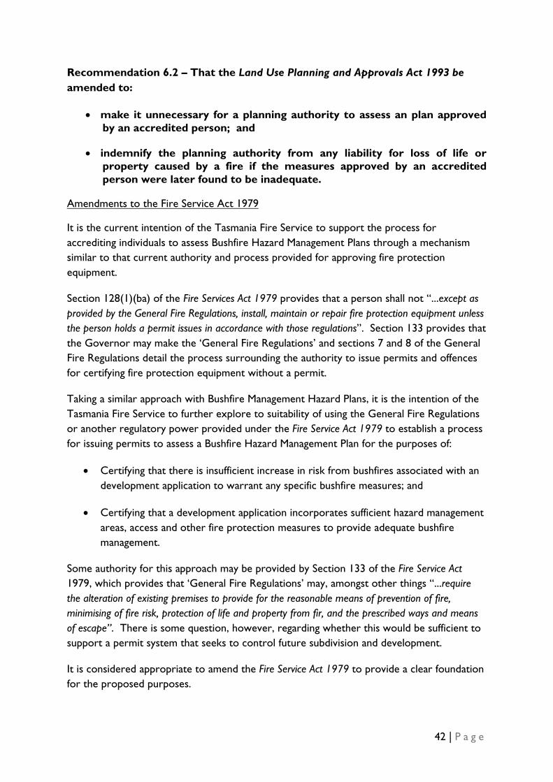
42 | P a g e
Recommendation 6.2 – That the Land Use Planning and Approvals Act 1993 be amended to:
• make it unnecessary for a planning authority to assess an plan approved by an accredited person; and
• indemnify the planning authority from any liability for loss of life or property caused by a fire if the measures approved by an accredited person were later found to be inadequate.
It is the current intention of the Tasmania Fire Service to support the process for accrediting individuals to assess Bushfire Hazard Management Plans through a mechanism similar to that current authority and process provided for approving fire protection equipment.
Amendments to the Fire Service Act 1979
Section 128(1)(ba) of the Fire Services Act 1979 provides that a person shall not “...except as provided by the General Fire Regulations, install, maintain or repair fire protection equipment unless the person holds a permit issues in accordance with those regulations”. Section 133 provides that the Governor may make the ‘General Fire Regulations’ and sections 7 and 8 of the General Fire Regulations detail the process surrounding the authority to issue permits and offences for certifying fire protection equipment without a permit.
Taking a similar approach with Bushfire Management Hazard Plans, it is the intention of the Tasmania Fire Service to further explore to suitability of using the General Fire Regulations or another regulatory power provided under the Fire Service Act 1979 to establish a process for issuing permits to assess a Bushfire Hazard Management Plan for the purposes of:
• Certifying that there is insufficient increase in risk from bushfires associated with an development application to warrant any specific bushfire measures; and
• Certifying that a development application incorporates sufficient hazard management areas, access and other fire protection measures to provide adequate bushfire management.
Some authority for this approach may be provided by Section 133 of the Fire Service Act 1979, which provides that ‘General Fire Regulations’ may, amongst other things “...require the alteration of existing premises to provide for the reasonable means of prevention of fire, minimising of fire risk, protection of life and property from fir, and the prescribed ways and means of escape”. There is some question, however, regarding whether this would be sufficient to support a permit system that seeks to control future subdivision and development.
It is considered appropriate to amend the Fire Service Act 1979 to provide a clear foundation for the proposed purposes.

43 | P a g e
Recommendation 6.3 - That Fire Service Act 1979 is amended to provide clear authority for issuing permits to assess Bushfire Hazard Management Plans for the purposes of:
• Certifying that there is insufficient increase in risk from bushfires associated with an development application to warrant any specific bushfire measures; and
• Certifying that a development application incorporates sufficient hazard management areas, access and other fire protection measures to provide adequate bushfire management.

44 | P a g e
9. Impact of Proposed Schedule and Definition
It was not considered necessary to complete a full cost-benefit analysis of the proposed definition of ‘bushfire prone area’ or draft Planning Directive as:
• The review largely standardises/codifies requirements that currently exist either in a significant majority of planning schemes or in the Tasmania Fire Service’s Guidelines for Development in Bushfire Prone Areas of Tasmania 2005 (which are used a basis for exercising Council discretion in most cases);
• The Tasmanian Planning Commission has reviewed a number of planning schemes that include similar or identical requirements in recent years and found them to be appropriate having regard to the objective of sustainable development in Tasmania;
• The proposed schedule provides greater flexibility for development in the State compared to many provisions of existing schemes;
• A national cost-benefit analysis was conducted for recent amendments to the Australian Standard AS3959 that refer to the costs of applying the standard compared to construction in the absence of any bushfire mitigation requirements (which is currently not the case in Tasmania in all but a small number of planning schemes).
As outlined previously, a full Regulatory Impact Statement was completed during the development and national agreement to AS3959-2009 Construction of buildings in bushfire-prone areas. This RIS identified that the estimated cost of the application of the construction standard (without reference to standards that may already be in place) ranged from $11,535 to $21,428 for standards applied at BAL 12.5 and from $20,885 to $76,679 for standards applied at BAL-FZ. The actual cost for construction of any property will be driven by individual designs and the capacity for the building to accommodate separation distance from bushfire prone vegetation.
The proposed Directive does not impact on these costs. The Directive does not add any additional construction requirements or force developers to adopt construction standards that would not otherwise be the case in the absence of the schedule. The acceptable solutions do, however, give confidence to developers that a Council will not reject an application for development on the grounds of ‘hazard management’ if the placing of the building provides for separation distances prescribed for BAL-19 (for subdivision) or BAL-29 (for development on existing titles). This would limit the potential cost exposure for developers.
Both the acceptable solution and the proposed performance criteria accommodate development that cannot meet the separation distances prescribed for BAL-19 (for subdivision) or BAL-29 (for development on existing titles), where it is in accordance with a plan prepared to the satisfaction of the Tasmania Fire Service or a person accredited by the

45 | P a g e
Tasmania Fire Service. The cost of this plan will vary depending on the complexity but is likely to be within the range of $400 - $1,000.
There are two standards applied under the proposed arrangements that are outside of the requirements of AS3959-2009: water supply for fire fighting purposes and fire fighting access and egress. The estimated impact of these requirements are:
The proposed Directive provides that an acceptable solution to supply of water for fire fighting purposes is connection to a fire hydrant of appropriate capacity for provision of a stored water tank, swimming pool, dam or lake with a capacity of at least 10,000 litres for each separate building.
Water Supply for Fire Fighting Purposes
10,000 litre water tanks are currently available in the marketplace for between $2,000 - $3,000 plus installation costs
23,000 litres tanks, which would provide adequate supply for both domestic water use and for fire fighting purposes are available for$3,000 - $4,000 plus installation costs.
The differential cost between installation of water supply for domestic purposes and for fire fighting purposes as required by the proposed standard is therefore likely to be in the order of $1,000-$2,000. This is not considered to be a significant increase in the costs associated with building a new property.
It is noted that similar standards for water supply infrastructure are currently being applied in a large number of municipalities. The impact of the proposed schedule in these areas will be small or negligible.
Advice was sought from a consultant (GHD) on the cost implications of the access and egress requirements prescribed within the acceptable solution of the draft planning Directive. The advice of the consultant was that the costs associated with the road infrastructure was around $200 per linear metre but that this cost was not likely to be substantially greater than the costs associated with providing appropriate private access to properties in the absence of the standard.
Fire Fighting Access and Egress
It is noted that similar standards for access and egress infrastructure are currently being applied in a large number of municipalities. The impact of the proposed Directive in these areas will be small or negligible.
Assessing bushfire risk is an acceptable requirement for development in bushfire prone areas and is arguably an essential component of promoting sustainable development in Tasmania. The proposed bushfire prone area definition and draft Directive apply reasonable
Summary of Estimated Impacts

46 | P a g e
standards for the assessment of risk and apply an appropriate balance between promoting safe and sustainable communities and the accommodating the reasonable desire of individuals, communities and industry to develop land.
AS3959-2009 has been considered through a national regulatory impact process and endorsed by all States and Territories. The actions recommended by this review do not imposed additional costs for construction over and above those considered in that national process.
The costs associated with the additional issues considered in the draft Directive, namely water support and access, are considered to be low and well with reasonable costs that should be borne by individuals seeking to develop in bushfire prone areas.
47 | P a g e
10. Other Issues that Arose During Review
A number of issues have arisen that are considered outside of the scope of the review but are relevant to promoting appropriate bushfire risk mitigation in Tasmania. These are:
Whist essential for managing bushfire risk into the future, the recommendations of this review will only guide bushfire mitigation measures for new subdivisions, dwellings and dwelling extensions that require development approval. These measures will not impact on existing properties in bushfire prone areas.
Risk Mitigation Measures for Existing Properties
Emergency Services, the State Government and Councils cannot manage all of the risks associated with bushfires for all people. Ongoing education, together with targeted support in priority areas will be critical to building and maintaining an appropriate safety culture in bushfire prone areas.
An assessment of the current arrangements for assisting individuals, families and communities to manage the risk of bushfires for existing properties is outside of the scope of this review.
A frequent retort to commentary regarding bushfire risk mitigation is that growing controls on vegetation clearance inhibit the capacity of landowners to reduce the fuel-load around properties. It is not clear whether this is a real or perceived concern. It should be noted, however, that Tasmania does not generally have the stringent controls on vegetation removal that have been referred to in the Victorian Royal Commission. Indeed some planning schemes already exempt vegetation clearance from planning controls where it is required for bushfire mitigation.
Vegetation Clearance Controls
Consideration of the interaction between bushfire risk mitigation and vegetation clearance controls was considered outside of the scope of this review. It is possible, however, that Victorian Bushfire Royal Commission may consider the relevance of vegetation clearance controls on bushfire risk and the ability to defend lives and properties in extreme circumstances. Any outcomes in this area should be considered further after the Royal Commission has released its final report.
A number of Councils noted that there are limited powers to support enforcement of conditions imposed on planning permits and that there are limited resources available for ongoing bushfire audits of land in bushfire prone areas. Both of these issues are important element of ongoing bushfire risk mitigation but are considered outside of the scope of this review.
Bushfire Risk Audits and Enforcement

48 | P a g e
With regard to powers to support the enforcement of conditions imposed on planning permits, it is noted that the recent State planning review recommended that
...the Government introduce improved enforcement provisions, particularly in relation to the ability of councils to issue infringement notices and associated penalties, as suggested in the Better Planning Outcomes Report, as follows:
That enforcement measures be included in LUPAA to provide for:
1. Infringement Notices to be issued;
2. Councils to recover the costs of enforcement;
3. enforcement of Part 5 agreements;
4. the cancellation or amendment of planning permits by the Tribunal;
5. authorised officers to be designated for the purpose of undertaking compliance activities;
6. a properly authorised officer to require a person to give information in relation to use or development activities etc;
7. a properly authorised officer to enter onto land to inspect and collect evidence;
8. a properly authorised officer to apply for the issue of a warrant to enter a house, where there is strong evidence of a breach of the Act or an instrument made under the Act such as a planning scheme;
9. a Temporary Stop Work Notice to be issued by an authorised officer for specified development works;
10. a properly authorised officer to issue a Show Cause Notice in circumstances when it appears that the issue of such a notice may achieve a more effective result than commencement of a prosecution;
11. an Enforcement Notice to be issued requiring a person to cease a use or development that is not authorised by a planning permit or is not being undertaken legally; and
12. penalties to be paid to the prosecuting authority;
That in addition, there is a need to:
1. revise the existing offence provisions in LUPAA so that there are a number of specifically identified offences rather than just the existing two ‘general’ offences;
2. introduce provisions that have higher penalties when offences are committed by corporations;
3. introduce a provision in LUPAA requiring planning authorities to develop a compliance plan in relation to permits issued;
4. amend the Building Act 2000 to better integrate with LUPAA;
49 | P a g e
5. amend LUPAA to increase the time within which a prosecution must be commenced for non compliance from the six months that is required under the Justices Act 1959 to twelve months.
It is understood that relevant legislation providing for these enforcement powers is to be introduced into Parliament in the near future.
Part 5 Agreements under the Land Use Planning and Approval Act 1993 are frequently used to establish management prescriptions for maintaining vegetation on the site and for adjoining land. These agreements run with, and are noted on the title. Concerns have been raised about their efficiency and the ability to enforce them. The changes proposed to the enforcement provisions of LUPAA will assist in addressing this issue.
A number of stakeholders have raised the complexities associated with managing bushfire risk where the bushfire prone vegetation is on adjoining land and where it is not practicable to accommodate reasonable separation distances on each title. This complexity is acknowledged but it is also noted that managing issues beyond the scope of an individual title is a major function of the State’s planning system.
Adjoining Land
In ‘greenfield areas’, the bushfire risk should be managed firstly through regional level strategic planning to ensure that, wherever possible, high risk uses are built outside of bushfire prone areas. Where this is not practicable, bushfire risk should be managed in the design of the subdivision. Only where these higher-level planning approaches are unavailable, should bushfire risk be managed at the development/use application stage.
There will, however, be many examples of bushfire mitigation measures that require the cooperation of neighbouring landowners. This may include, for example, clear space for maintaining separation from bushfire prone vegetation or appropriate maintenance of access.
It is a role of planning authorities to manage these issues in the way considered most appropriate for that municipality. It is noted, however, that Part 5 of the Land Use Planning and Approvals Act 1993 provides that a planning authority can enter into agreements with land owners to, amongst other things, prescribe the conditions subject to which a use or development may be undertaken. A number of planning authorities already use these agreements to manage requirements to maintain bushfire mitigation measures.
It was suggested during the review that there are many examples of existing issues associated with bushfire prone vegetation abutting properties either through limited consideration being given to the issue at the development/use application stage or through a lack of appropriate maintenance of neighbouring properties. The recommendations of this review will not address these issues and they should be subject to ongoing consideration by planning authorities and, where appropriate, the Tasmania Fire Service.

50 | P a g e
Reducing the risks of bushfires cannot be managed by planning authorities alone. It is critical that Tasmania Fire Service continue to support Councils to identify high priority bushfire risk issues and to provide appropriate expertise to identify solutions to reducing bushfire risk. The Tasmania Fire Service supports the need for a continued focus on supporting Councils in this area.
Support for Councils

Draft Planning Directive No.4
Use and Development in Bushfire Prone Areas.
1.0 Introduction 1.1 Planning Directive No.4 provides State-wide subdivision, use and development
controls for Bushfire Prone Areas. 2.0 Effect of the Planning Directive 2.1 In this planning directive, unless the contrary intention appears:
BAL means Bushfire Attack Level as defined in AS3959 – 2009 Construction of buildings in bushfire-prone areas.
Building Area means the area shown on a plan of subdivision to indicate where the main building will be located.
Bushfire Hazard Management Plan means a plan drawn to scale showing the Hazard Management Area in relation to existing and proposed buildings, roads and lot boundaries together with vegetation to be planted, retained, managed, removed or protected in accordance with any necessary vegetation management approvals,
Bushfire Prone Area means an area of land which is subject, or likely to be subject to bushfires being any area of land within 100m of a contiguous area of vegetation of greater than 1ha.
A Bushfire Prone Area does not include land over 20m from a contiguous area of vegetation less than 20m in width regardless of length.
Areas of vegetation separated by less than 20m are to be considered as a contiguous area of vegetation for the purposes of defining a Bushfire Prone Area.
Fine Fuel means bracken, dead or fallen material such as leaves, bark and twigs up to 6mm in diameter.
Habitable Building means a building classified as a Class 1, 2, 3, 4, 5, 6, 7, 8 or 9 Building under the Building Code of Australia. This does not include a Class 10 non-habitable building or structure.
Hazard Management Area means the area between the building (or Building Area) and the bushfire hazard which provides access to a fire front for fire fighting and which is maintained so there are no fine fuels or other hazards present which will significantly contribute to the spread of a bushfire. This is achieved where:
(i) ground cover and vegetation litter is maintained in a minimum fuel condition; and
(ii) fire hazards, such as wood piles, rubbish heaps, stored fuels, fine fuels and the like, are removed; and
(iii) there are non-flammable features such as paths, driveways, dams, swimming pools, vegetable gardens, on-site waste disposal systems, hedgerows, concrete or stone fences, and the like; and

52 | P a g e
(iv) tree canopies are separated from each other horizontally and vertically from ground cover and vegetation litter.
Residential building means a building classified as a Class 1, 2 or 3 building under the Building Code of Australia.
Vegetation for the purpose of the definition of bushfire-prone area, means any vegetation classified under AS 3959 – 2009 Construction of buildings in bushfire-prone areas, but does not include:
i) non-vegetated areas, such as waterways, roads, footpaths, buildings and rocky outcrops; or
ii) low threat vegetation, including maintained lawns, golf courses, maintained public reserves and parklands, botanical gardens, vineyards, orchards, cultivated ornamental gardens, commercial nurseries, nature strips, windbreaks and managed agricultural land other than plantation forestry; or
iii) grasslands other than tussock moorland. Tussock moorland is defined as vegetation types dominated by Buttongrass (Gymnoschoenus sphaerocephalus).
2.2 All use and development in areas defined as bushfire prone is to be assessed against
the provisions of this Planning Directive with the exception of the following:
a) A use that is not a residential use or a vulnerable and hazardous use listed in clause 4.3 of this Planning Directive;
b) A structure or building which is not a habitable building;
c) Internal and external alterations, maintenance and repairs to a habitable building;
d) An extension, addition, deck or verandah with an area of not more than 20m2 and not within an area required as a Hazard Management Area; and
e) Buildings that are integral to the agricultural use of the land and are not normally occupied.
2.4 The Planning Directive replaces existing provisions or the absence of any provisions for bushfire protection in planning schemes.
3.0 Commencement 3.1 This planning directive takes effect on the day on which notice of its issue is
published in the Gazette. [If the Minister issues the planning directive under s.13(2) of the Act, planning schemes will be modified as necessary by the Commission in accordance with s.14 of the Act to include the standard provisions for bushfire]

53 | P a g e
4. Provisions for Use and Development in Bushfire Prone Areas 4.1 Purpose of Provisions
4.1.1 The purpose of these provisions is to ensure that use and development in a Bushfire Prone Area is appropriately planned, located and serviced to minimise the risk to human life and property and to minimise the cost to the community caused by bushfires.
4.2 Application and Determination
4.2.2 An application for a permit must provide sufficient documentation to enable assessment of compliance with these provisions.
4.2.3 The Planning Authority must grant a permit for an application which meets an acceptable solution in respect to each applicable use and development standard in these provisions unless clause 4.3 applies or the use or development is discretionary or prohibited by any other provision of the planning scheme.
4.2.4 Unless prohibited by any other provision of the planning scheme, a use or development is discretionary if clause 4.3 applies or it relies on one or more performance criteria to comply with any applicable standards.
4. 2.5 In determining a discretion under these provisions the Planning Authority must take into consideration:
1. the purpose of these provisions; and
2. the objectives and performance criteria of the applicable standards; and
3. any Bushfire Hazard Management Plan for the land; and
4. any advice, information or recommendation from the Tasmania Fire Service or a person permitted to accredit a bushfire Hazard Management Plan under the Fire Service Act 1979.
4.2.6 The Planning Authority must refuse an application which does not comply with all applicable standards in these provisions.
4.3 Vulnerable and Hazardous uses in Bushfire Prone Areas 4.3.1 Vulnerable and hazardous uses which accommodate people with special evacuation
needs or involve the presence of large amounts of hazardous materials are discretionary and may only be allowed in a bushfire prone area if there is an overriding benefit to the community, no suitable alternative site is available, and adequate protection from bushfire can be provided in accordance with a Bushfire Hazard Management Plan to the satisfaction of the Tasmania Fire Service.
Vulnerable and hazardous uses are: (a) aged care, dependent person or retirement accommodation; (b) educational or occasional care services; (c) hospital services or correctional institutions; or (d) manufacturing, processing and storage involving hazardous materials in bulk.

54 | P a g e
5.4. Standards for Use and Development in Bushfire Prone Areas 5.4.1 Hazard Management Areas
Objective: To ensure that subdivision, use and development of Habitable Buildings in a Bushfire Prone Area is adequately protected from bushfire hazards
Performance Criteria Acceptable Solution
P1. Subdivision must be designed to ensure adequate bushfire mitigation measures can be provided for all lots, including those developed at each stage of development, through a combination of Hazard Management Areas, access, and other fire protection measures in accordance with the Guidelines for Development in Bushfire Prone Areas of Tasmania, Tasmania Fire Service 2005.
A1.
(a) The Tasmania Fire Service or a person permitted to accredit a bushfire Hazard Management Plan under the Fire Service Act 1979 is satisfied that there is an insufficient increase in risk from bushfire to warrant any specific protection measures; or
(b) Lots for Residential Buildings including those developed at each stage of subdivision have Building Areas and Hazard Management Areas that have widths which comply with the separation distances prescribed for BAL 19 in Table 2.4.4 of AS 3959 – 2009 Construction of buildings in bushfire-prone areas, which will be managed by the owners of the affected land in accordance with a Bushfire Hazard Management Plan; or
(c) Adequate bushfire management for all lots will be provided through a combination of hazard management areas, access, and other fire protection measures to the satisfaction of the Tasmania Fire Service or a person permitted to accredit a bushfire Hazard Management Plan under the Fire Service Act 1979.
P2.Habitable Buildings must be provided with adequate bushfire mitigation measures through a combination of Hazard Management Areas, access, and other fire protection measures in accordance with Guidelines for Development in Bushfire Prone Areas of Tasmania, Tasmania Fire Service 2005.
A2. (a) The Tasmania Fire Service or a person permitted to accredit a bushfire Hazard Management Plan under the Fire Service Act 1979 is satisfied that there is an insufficient increase in risk from bushfire to warrant any specific protection measures; or
(b) Residential Buildings will each have a Hazard Management Area which has widths which are equal to or greater than the separation distances required for BAL 29 prescribed in Table 2.4.4 of AS 3959 – 2009 Construction of
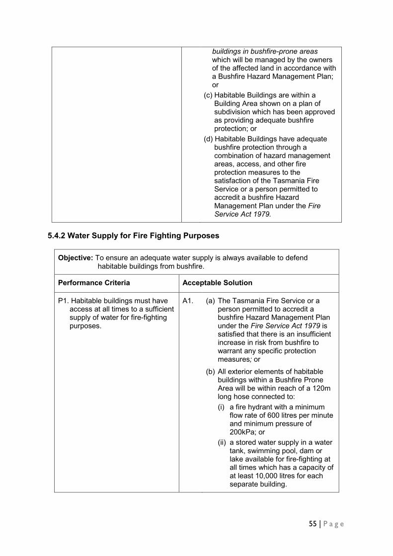
55 | P a g e
buildings in bushfire-prone areas which will be managed by the owners of the affected land in accordance with a Bushfire Hazard Management Plan; or
(c) Habitable Buildings are within a Building Area shown on a plan of subdivision which has been approved as providing adequate bushfire protection; or
(d) Habitable Buildings have adequate bushfire protection through a combination of hazard management areas, access, and other fire protection measures to the satisfaction of the Tasmania Fire Service or a person permitted to accredit a bushfire Hazard Management Plan under the Fire Service Act 1979.
5.4.2 Water Supply for Fire Fighting Purposes
Objective: To ensure an adequate water supply is always available to defend habitable buildings from bushfire.
Performance Criteria Acceptable Solution
P1. Habitable buildings must have access at all times to a sufficient supply of water for fire-fighting purposes.
A1.
(a) The Tasmania Fire Service or a person permitted to accredit a bushfire Hazard Management Plan under the Fire Service Act 1979 is satisfied that there is an insufficient increase in risk from bushfire to warrant any specific protection measures; or
(b) All exterior elements of habitable buildings within a Bushfire Prone Area will be within reach of a 120m long hose connected to: (i) a fire hydrant with a minimum
flow rate of 600 litres per minute and minimum pressure of 200kPa; or
(ii) a stored water supply in a water tank, swimming pool, dam or lake available for fire-fighting at all times which has a capacity of at least 10,000 litres for each separate building.

56 | P a g e
5.4.3 Fire Fighting Access and Egress
Objective: To ensure adequate and safe fire-fighting access in a Bushfire Prone Area.
Performance Criteria Acceptable Solution
P1. Subdivision must be designed to provide safe access for fire fighting vehicles in accordance with Guidelines for Development in Bushfire Prone Areas of Tasmania, Tasmania Fire Service 2005.
A1. (a) The Tasmania Fire Service or a person permitted to accredit a bushfire Hazard Management Plan under the Fire Service Act 1979 is satisfied that there is an insufficient increase in risk from bushfire to warrant fire fighting access; or
(b) Subdivision that could result in lots for Habitable Buildings will have Building Areas that are within 200m of a through road including at each stage of a staged subdivision and the road and private access will meet the requirements of Table 5.4.3, or
(c) Subdivision must indicate how safe access for fire fighting vehicles will be provided to the satisfaction of the Tasmania Fire Service.
P2. Habitable Buildings and associated water supply point hardstand area must have safe and appropriately designed and dimensioned access for fire fighting vehicles.
A2. (a) The Tasmania Fire Service or a person permitted to accredit a bushfire Hazard Management Plan under the Fire Service Act 1979 is satisfied that there is an insufficient increase in risk of bushfire to warrant fire fighting access; or
(b) Habitable buildings will have private access in compliance with Table 5.4.3: (i) from a road to within 30m of
the furthest part of the buildings measured as a hose lay; and
(ii) to the water supply point hardstand area, or
(c) Access is in accordance with a plan of subdivision which has been approved as providing adequate access for fire fighting vehicles; or
(d) Buildings and associated water supply points will have access for fire fighting vehicles to the satisfaction of the Tasmania Fire Service.
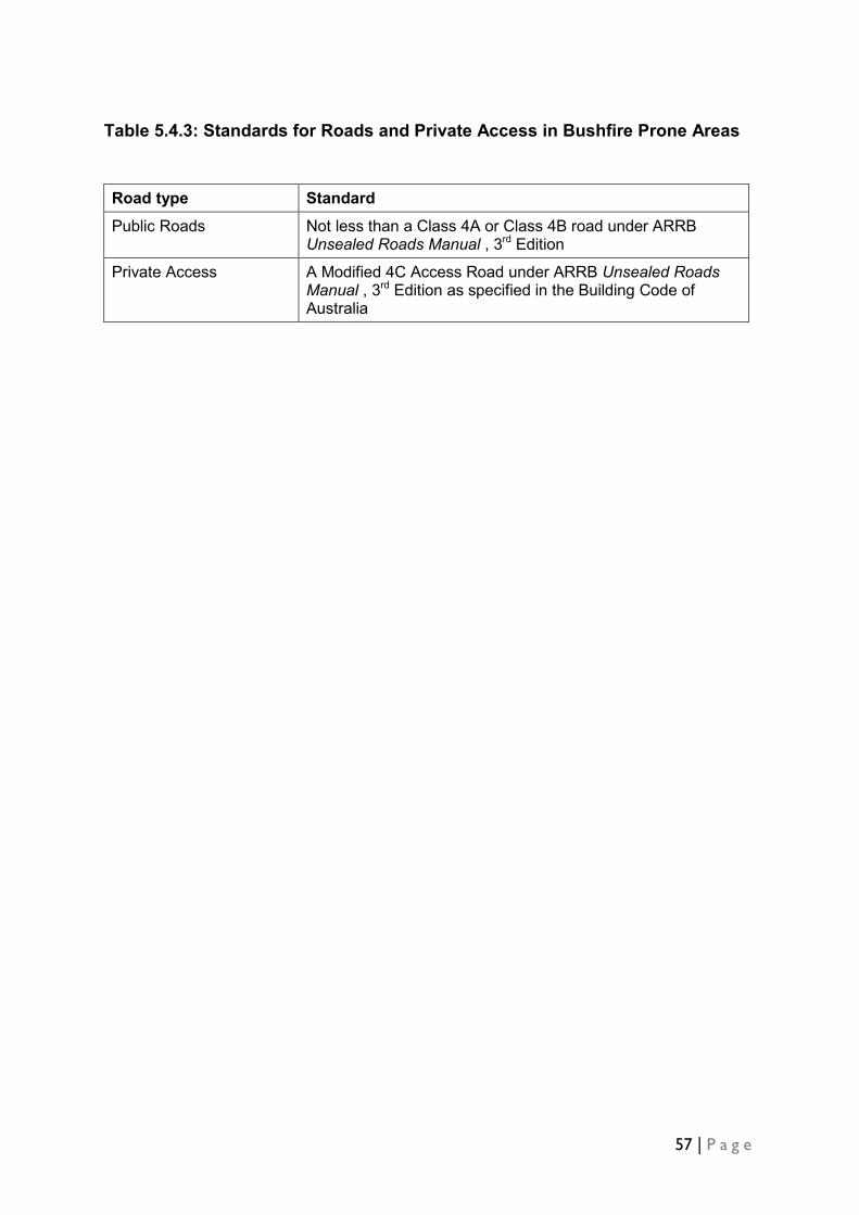
57 | P a g e
Table 5.4.3: Standards for Roads and Private Access in Bushfire Prone Areas
Road type Standard
Public Roads Not less than a Class 4A or Class 4B road under ARRB Unsealed Roads Manual , 3rd Edition
Private Access A Modified 4C Access Road under ARRB Unsealed Roads Manual , 3rd Edition as specified in the Building Code of Australia

58 | P a g e
Department of Premier and Cabinet, Tasmania Office of Security and Emergency Management Email: [email protected] Visit: www.dpac.tas.gov.au
ISBN: 978 0 7246 5569 7 Published September 2010 Copyright State of Tasmania 2010