Embed Size (px)
Citation preview

Review of Landslides
in 2008
GEO Report No. 274
A.C.O. Li, J.W.C. Lau, L.L.K. Cheung & C.L.H. Lam
Geotechnical Engineering Office
Civil Engineering and Development Department
The Government of the Hong Kong Special Administrative Region

Review of Landslides
in 2008
GEO Report No. 274
A.C.O. Li, J.W.C. Lau, L.L.K. Cheung & C.L.H. Lam
This report was originally produced in December 2009
as GEO Landslide Study Report No. LSR 15/2009

2
© The Government of the Hong Kong Special Administrative Region
First published, December 2012
Prepared by:
Geotechnical Engineering Office,
Civil Engineering and Development Department,
Civil Engineering and Development Building,
101 Princess Margaret Road,
Homantin, Kowloon,
Hong Kong.

3
Preface
In keeping with our policy of releasing information
which may be of general interest to the geotechnical
profession and the public, we make available selected internal
reports in a series of publications termed the GEO Report
series. The GEO Reports can be downloaded from the
website of the Civil Engineering and Development Department
(http://www.cedd.gov.hk) on the Internet. Printed copies are
also available for some GEO Reports. For printed copies, a
charge is made to cover the cost of printing.
The Geotechnical Engineering Office also produces
documents specifically for publication in print. These include
guidance documents and results of comprehensive reviews.
They can also be downloaded from the above website.
The publications and the printed GEO Reports may be
obtained from the Government‟s Information Services
Department. Information on how to purchase these documents
is given on the second last page of this report.
Y.C. Chan
Head, Geotechnical Engineering Office
December 2012

4
Foreword
This report presents the findings of a detailed diagnosis
of landslides in 2008 that were reported to the Government. It
serves to review the performance of the Government‟s slope
safety system and identify areas for improvement, as well as to
further enhance the slope engineering practice in Hong Kong.
The review was carried out by Dr A.C.O. Li,
Mr J.W.C. Lau, Ms L.L.K. Cheung and Ms C.L.H. Lam of
Landslip Preventive Measures Division 1 under the supervision
of Mr W.K. Pun. Assistance was provided by the landslide
investigation consultants, Fugro Scott Wilson Joint Venture and
AECOM Asia Company Limited respectively, engaged by the
Geotechnical Engineering Office (GEO). Technical support
provided by Mr C.C. Mak, Mr T.F.O. Luk and Mr K.H.K. Yiu is
gratefully acknowledged.
R.K.S. Chan
Head of the Geotechnical Engineering Office

5
Abstract
This report presents the findings of a diagnostic review of the landslides in 2008 that
were reported to the Government. The review forms part of the GEO‟s systematic landslide
investigation programme, which is an integral component of the Government‟s slope safety
system. The aims of this report are to review the performance of the Government‟s slope
safety system and identify areas for improvement, as well as to further enhance the slope
engineering practice in Hong Kong.
Altogether 863 genuine landslides were reported to the Government in 2008. All the
available landslide data were examined and 16 follow-up studies on selected landslide
incidents were being carried out under the systematic landslide investigation programme.
These studies provided information and insights into the types, causes and mechanisms of
landslides, and facilitated the identification of areas deserving attention and improvement.
Based on the landslide data in 2008, two major landslides (viz. failure volume of 50 m³
or more) occurred on engineered man-made slopes that have been accepted under the slope
safety system. The corresponding annual failure rate is about 0.009% on a slope number
basis (i.e. number of landslides relative to the total number of engineered slopes). In terms
of minor landslides (viz. failure volume of less than 50 m³) on engineered man-made slopes,
the annual failure rate is about 0.112% on a slope number basis.
Overall, 99.88% of the engineered man-made slopes performed satisfactorily without
occurrence of landslides in 2008.
Recommendations for further improvement of the slope safety system and slope
engineering practice in Hong Kong are given in this report.

6
Contents
Page
No.
Title Page 1
Preface 3
Foreword 4
Abstract 5
Contents 6
List of Tables 8
List of Figures 9
1 Introduction 10
2 Rainfall and Landslides in 2008 10
3 Severity of Rainstorms as Reflected by Landslide Potential Index 15
4 Overall Diagnostic Review of Landslides 15
4.1 General 15
4.2 Coverage of the New Catalogue of Slopes 18
4.2.1 General 18
4.2.2 Diagnosis 18
4.3 Performance of Registered Man-made Slopes 21
4.3.1 General 21
4.3.2 Landslides on Engineered Slopes 22
4.3.3 Landslides on Non-engineered Slopes 34
4.3.4 Annual Failure Rates 36
4.4 Key Observations 38
4.4.1 Severity of Rainstorms that Triggered Landslides 38
Involving Man-made Slopes
4.4.2 Comparison of Rainfall and Landslide History 39
between Two Significant Rainstorms in
August 2005 and June 2008

7
Page
No.
4.4.3 Landslides with Inadequate Slope Maintenance 42
Diagnosed as a Key Contributory Factor to Failure
4.4.4 Landslides Affecting Squatters 42
4.4.5 Natural Terrain Landslides 45
4.4.5.1 Overview 45
4.4.5.2 Large-scale Landslides 45
4.4.5.3 Presence of Recent Debris Fans 46
4.4.6 Landslides on Hillside Pockets Close to 46
Developments in Urban Areas
4.4.7 Coverage of the Historical Landslide Catchment 51
Inventory
5 Proposed Improvement Initiatives 51
6 Conclusions 55
7 References 55
Appendix A: Factors Affecting the Performance of Man-made Slopes 57

8
List of Tables
Table
No.
Page
No.
2.1 Breakdown of Landslides by Type of Slope Failure
11
2.2 Breakdown of Landslides by Type of Affected Facility
12
2.3 Breakdown of Landslide Consequences by Type of Slope
Failure
13
2.4 Breakdown of Facility Groups Affected by Major
Landslides
14
2.5 Breakdown of Scale of Failures by Type of Slope
14
3.1 Rainfall and Landslide Data for the 23 July 1994,
20 August 2005 and 7 June 2008 Rainstorms
17
4.1 Landslide Incidents Involving Slopes Processed under the
Slope Safety System
23
4.2 Breakdown of Landslides on Engineered Slopes
34
4.3 Breakdown of Landslides on Slopes Previously Treated
under the LPM Programme
35
4.4 Breakdown of Key Contributory Factors to Landslides on
Engineered Unsupported Cut Slopes
35
4.5 Annual Failure Rates of Registered Man-made Slopes in
2008
37
4.6 Breakdown of Annual Failure Rates of Registered
Man-made Slopes
38
4.7 Annual Success Rates of Engineered Slopes from 1997 to
2008
40
5.1 Progress of Follow-up Actions on the Improvement
Measures Recommended in the Review of 2007
Landslides
54

9
List of Figures
Figure
No.
Page
No.
3.1 Landslide Potential Index for Rainstorms that Resulted in
the Issue of Landslip Warning from 1984 to 2008
16
3.2 Locations of GEO and HKO Automatic Raingauges
19
4.1 Breakdown of Landslides on Unregistered Slopes in 2008
20
4.2 Annual Success Rates of Engineered Slopes from 1997 to
2008
41
4.3 Maximum Rolling 24-hour Rainfall Distribution for the
20 August 2005 Rainstorm and Locations of Landslides
43
4.4 Maximum Rolling 24-hour Rainfall Distribution for the
7 June 2008 Rainstorm and Locations of Landslides
44
4.5 Location Plan of the 7 June 2008 Landslide on the Hillside
behind HKU
47
4.6 Accumulation of Colluvial Deposits on the Hillside behind
HKU
48
4.7 Location Plan of the 7 June 2008 Landslides on the
Hillside above Yu Tung Road
49
4.8 Area of Boulderly Deposits on the Hillside above Yu
Tung Road
50
4.9 Location Plan of the 7 June 2008 Landslide behind
Rockwin Court, Fung Fai Terrace
52
4.10 Overall Setting of the Hillside behind Rockwin Court,
Fung Fai Terrace
53

10
1 Introduction
This report presents the findings of a diagnostic review of the landslides in 2008 that
were reported to the Geotechnical Engineering Office (GEO) of the Civil Engineering and
Development Department (CEDD). The review forms part of GEO‟s systematic landslide
investigation (LI) programme, which is an integral component of the Government‟s slope
safety system. The LI programme has the following two principal objectives:
(a) to identify, through studies of landslides, slopes that are
affected by inherent instability problems so that appropriate
follow-up actions can be taken for integrated slope
assessment and upgrading works, and
(b) to review the performance of Government‟s slope safety
system and identify areas for improvement in slope
engineering practice.
The present diagnostic review considers all the available landslide data in 2008,
including the findings of the individual landslide studies. The review has been carried out
by the Landslip Preventive Measures Division 1 (LPM1) of the GEO, with assistance
provided by GEO‟s LI consultants, namely Fugro Scott Wilson Joint Venture (FSWJV) and
AECOM Asia Company Limited (AECOM) respectively.
2 Rainfall and Landslides in 2008
The factual information, together with the relevant statistics on rainfall and reported
landslides in 2008, was documented by Lam et al (2009).
In 2008, the annual rainfall recorded at the Principal Raingauge of the Hong Kong
Observatory (HKO) in Tsim Sha Tsui was 3,066 mm, which was approximately 29% above
the mean annual rainfall of 2,383 mm recorded between 1971 and 2000. Five Landslip
Warnings were issued between 19 April and 10 July 2008. Two Black Rainstorm Warnings
were issued on 19 April and 7 June 2008; seven Red Rainstorm Warnings were issued
between 19 April and 12 July 2008; and 21 Amber Rainstorm Warnings were issued between
19 April and 5 October 2008.
Reported landslides are classified as follows:
(a) minor failure (i.e. failure volume < 50 m³), and
(b) major failure (i.e. failure volume ≥ 50 m³ or where a fatality
has occurred).
In the present context, failure volume refers to the sum total of the volume of detached
material and the volume of any deformed material that remains on the slope that may, or may
not, have displaced significantly.
Of a total of 868 reported landslide incidents in 2008, 863 were genuine landslides,

11
discounting the non-landslide incidents (e.g. tree falls). There were 160 major failures,
corresponding to about 18.5% of the number of genuine landslides.
The distribution of landslides, as classified by the type of slope failure, is given in
Table 2.1. The range of facilities affected by the landslides is summarised in Table 2.2.
The consequences of the landslides in relation to the type of slope failure are summarised in
Table 2.3. The distribution of the different facility groups (classification given in
Wong (1998)) affected by the major landslides is depicted in Table 2.4. The distribution of
the scale of failures, as classified by the type of slope involved, is given in Table 2.5.
Table 2.1 Breakdown of Landslides by Type of Slope Failure
Type of Slope Failure Number Percentage (%)
Fill Slopes 52 (9) 6.0
Cut Slopes
Soil 308 (11) 35.7
Soil/Rock 131 (10) 15.2
Rock 13 (1) 1.5
Retaining Walls 45 (4) 5.2
Natural Hillsides 301 (124) 34.9
Registered Disturbed Terrain 13 (1) 1.5
Total 863 (160) 100
Legend:
52 (9) 52 landslides, nine of which were major failures (i.e. failure volume ≥ 50 m³).
Notes: (1) Where a landslide involved more than one type of failure, the predominant
type of failure has been considered in the above classification.
(2) Incidents that were not genuine landslides have been excluded.
All the available data on reported landslides were examined as part of the current
review. Some additional information was collated by GEO‟s LI consultants to assist in the
selection of deserving cases for follow-up studies. A total of 16 follow-up studies on
selected landslide incidents in 2008 were carried out by the LI consultants or the in-house
study team of LPM1.
The individual landslide studies have provided valuable information and insights into
the types, causes and mechanisms of landslides. The study reports are lodged in the Civil
Engineering Library. A summary of the key findings is presented in the Hong Kong Slope
Safety Website (http://hkss.cedd.gov.hk/hkss/eng/studies/lic/index.htm). Following the
completion of the landslide studies, the key lessons learnt are identified and recommendations
made on the necessary follow-up actions.

12
Table 2.2 Breakdown of Landslides by Types of Affected Facility
Type of Affected Facility Hong Kong
Island Kowloon
New
Territories
and
Outlying
Islands
All
Buildings 14 (8) 1 (0) 67 (13) 82 (21)
Registered Squatter Dwellings 2 (0) 3 (1) 60 (11) 65 (12)
Roads 24 (5) 5 (0) 74 (30) 103 (35)
Transportation Facilities
(e.g. railways, tramways, etc.) 0 (0) 0 (0) 0 (0) 0 (0)
Pedestrian Pavements/Footways 8 (1) 2 (0) 8 (1) 18 (2)
Minor Footpaths/Access Paths 62 (6) 14 (0) 228 (41) 304 (47)
Construction Sites 2 (0) 0 (0) 3 (1) 5 (1)
Open Areas 29 (2) 16 (2) 84 (11) 129 (15)
Catchwaters 2 (0) 0 (0) 53 (7) 55 (7)
Others (e.g. carparks, parks,
playgrounds, gardens, backyards, etc.) 17 (4) 11 (2) 60 (10) 88 (16)
Nil Consequence 5 (1) 5 (3) 29 (9) 39 (13)
Total 165 (27) 57 (8) 666 (134) 888 (169)
Legend:
14 (8) 14 landslides, eight of which were major failures (i.e. failure volume ≥ 50 m³).
Notes: (1) A given landslide may affect more than one type of facility.
(2) Incidents that were not genuine landslides have been excluded.
(3) Nil consequence refers to incidents where the landslide debris came to rest
on areas with no proper access for the public (e.g. natural hillside, slope
berm, disused quarry surrounded by fence, etc.).

13
Table 2.3 Breakdown of Landslide Consequences by Type of Slope Failure
Type of Slope Failure
Number of Squatter
Dwellings (1)
Evacuated Number of
Floors,
Houses or
Flats
Evacuated or
Partially
Closed
Number of Closure
Deaths Injuries
Permanent Temporary Roads Pedestrian
Pavements
Footpaths,
Alleyways
or Private
Access
Paths
Fill Slopes 0 (0) 0 (0) 1 2 0 2 0 0
Cut Slopes
Soil 7 (7) 8 (8) 0 9 1 13 0 0
Soil/Rock 1 (1) 5 (5) 0 18 1 11 0 0
Rock 0 (0) 0 (0) 0 0 0 3 0 0
Retaining Walls 0 (0) 4 (4) 1 0 0 6 2 0
Natural Hillsides 31 (31) 11 (11) 33 27 1 23 0 0
Registered Disturbed Terrain 0 (0) 0 1 0 0 1 0 0
Total 39 (39) 28 (28) 36 56 3 59 2 0
Legend:
8 (8) Number of squatter dwellings evacuated, with the number of tolerated squatter structures evacuated shown in brackets.
Notes: (1) A squatter dwelling is defined as a place of residence that contains one or more tolerated squatter structures,
i.e. structures built for domestic purposes or non-domestic purposes and registered in 1982 Housing Department's
Squatter Structure Survey (GEO, 2004b).
(2) A failure may give rise to more than one type of consequence.

14
14
Table 2.4 Breakdown of Facility Groups Affected by Major Landslides
Type of Major Landslide
Facilities Group Affected by Major Landslides
(Group No.)
1a 1b 2a 2b 3 4 5
All Major Landslides 9 19 5 4 7 50 66
Major Landslides on
Man-made Slopes 4 2 2 1 2 15 9
Major Landslides on
Registered Disturbed
Terrain
0 0 0 1 0 0 0
Major Landslides on
Natural Hillsides 5 17 3 2 5 35 57
Notes (1) Facility groups are classified in accordance with that adopted for the New
Priority Classification Systems (Wong, 1998).
(2) A given landslide may affect more than one type of facility.
Table 2.5 Breakdown of Scale of Failures by Type of Slope
Type of Slope
Number of
Minor Failures
Number of
Major Failures Total
(< 50 m³) (50 m³ to < 500 m³) (≥ 500 m³)
Registered
Man-made Slopes 402 30 3 435
Registered
Disturbed Terrain
Features
12 0 1 13
Unregisterable
Man-made Slopes 77 1 0 78
Registerable
Man-made Slopes
Not Yet Registered
at Time of Failure
35 1 0 36
Natural Hillsides 177 101 23 301
Total 703 133 27 863

15
15
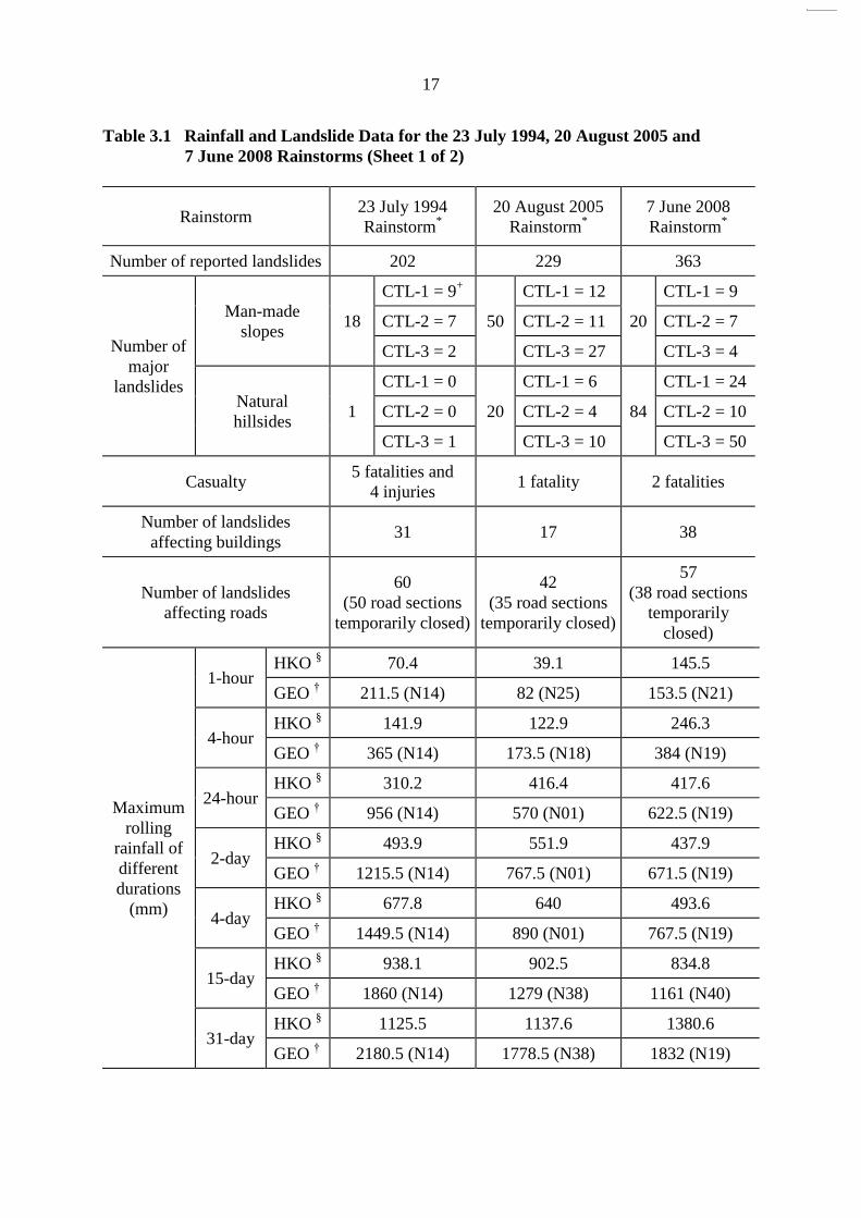
3 Severity of Rainstorms as Reflected by Landslide Potential Index
Experience has shown that the annual rainfall alone is not a good measure of the severity
of the individual rainstorms in terms of their potential to trigger landslides. A more direct
measure of the severity of the individual rainstorms in the context of landslides is given by the
Landslide Potential Index (LPI), as promulgated by the GEO (2009a). The LPI is calculated for
rainstorms that result in the issue of Landslip Warning and used to depict the relative severity of
the rainstorm with respect to its potential to cause landslides. The LPI, which is not a predictive
index (GEO, 2009a), is based on the 24-hour rainfall of a rainstorm. The LPI for rainstorms that
resulted in the issue of Landslip Warning from 1984 to 2008 is presented in Figure 3.1.
In 2008, five Landslip Warnings were issued between 19 April and 10 July 2008. The
LPI for the most severe rainstorm event on 7 June 2008 was 12, during which time the maximum
24-hour rolling rainfall recorded at GEO Raingauge No. N19 was 622.5 mm. As a result of the
7 June 2008 rainstorm, a total of 363 landslides were reported to the GEO, 104 of which were
classified as major failures including the fatal landslide at Cafeteria Old Beach (Incident No.
2008/06/0129) (Lam et al, 2009). The 7 June 2008 rainstorm also triggered many natural terrain
landslides in remote areas, which had not been reported to the Government.
In terms of its potential to cause landslides, the 7 June 2008 rainstorm was more severe
than the rainstorms of 23 July 1994 and 20 August 2005, both of which had an LPI of 10 and
had triggered landslides resulting in fatalities (viz. the 23 July 1994 landslide at Kwun Lung
Lau and the 20 August 2005 landslide at Fu Yung Shan Tsuen). A summary of the rainfall
and landslide data for the 23 July 1994, 20 August 2005 and 7 June 2008 rainstorms is
presented in Table 3.1 for comparison purposes.
4 Overall Diagnostic Review of Landslides
4.1 General
An overall diagnostic review of the available 2008 landslide data has been carried out
to appraise the slope performance, and facilitate the identification of areas in the slope safety
system for further improvement.
The diagnostic review has focused on the following aspects:
(a) coverage of the New Catalogue of Slopes,
(b) performance of registered man-made slopes, and
(c) observations from natural terrain landslides.
In addition, in response to a recommendation of the Slope Safety Technical Review
Board (SSTRB, 2009), an attempt has been made to list factors that could affect the
performance of man-made slopes based on a review of the landslides in 2008 and selected
notable landslides in recent years. Factors that GEO can influence have been separated from
those that are out of GEO‟s control. Other factors that may affect the performance of the slope
safety system have also been identified. The key findings are summarised in Appendix A.

16
0
2
4
6
8
10
12
14
16
19
84
19
85
19
86
19
87
19
88
19
89
19
90
19
91
19
92
19
93
19
94
19
95
19
96
19
97
19
98
19
99
20
00
20
01
20
02
20
03
20
04
20
05
20
06
20
07
20
08
Year
Lan
dsl
ide
Po
ten
tial
In
dex
20 August 2005 rainstorm23 July 1994 rainstorm
7 June 2008 rainstorm
Legend:
A rainstorm that resulted in the issue of Landslip Warning
Figure 3.1 Landslide Potential Index for Rainstorms that Resulted in the Issue of Landslip Warning from 1984 to 2008
0
2
4
6
8
10
12
14
16
1984
1985
1986
1987
1988
1989
1990
1991
1992
1993
1994
1995
1996
1997
1998
1999
2000
2001
2002
2003
2004
2005
2006
2007
2008
Year
Landsl
ide P
ote
nti
al
Index 20 August 2005 rainstorm23 July 1994 rainstorm
7 June 2008 rainstorm
17
17
Table 3.1 Rainfall and Landslide Data for the 23 July 1994, 20 August 2005 and
7 June 2008 Rainstorms (Sheet 1 of 2)
Rainstorm 23 July 1994
Rainstorm*
20 August 2005
Rainstorm*
7 June 2008
Rainstorm*
Number of reported landslides 202 229 363
Number of
major
landslides
Man-made
slopes 18
CTL-1 = 9+
50
CTL-1 = 12
20
CTL-1 = 9
CTL-2 = 7 CTL-2 = 11 CTL-2 = 7
CTL-3 = 2 CTL-3 = 27 CTL-3 = 4
Natural
hillsides 1
CTL-1 = 0
20
CTL-1 = 6
84
CTL-1 = 24
CTL-2 = 0 CTL-2 = 4 CTL-2 = 10
CTL-3 = 1 CTL-3 = 10 CTL-3 = 50
Casualty 5 fatalities and
4 injuries 1 fatality 2 fatalities
Number of landslides
affecting buildings 31 17 38
Number of landslides
affecting roads
60
(50 road sections
temporarily closed)
42
(35 road sections
temporarily closed)
57
(38 road sections
temporarily
closed)
Maximum
rolling
rainfall of
different
durations
(mm)
1-hour HKO
§ 70.4 39.1 145.5
GEO † 211.5 (N14) 82 (N25) 153.5 (N21)
4-hour HKO
§ 141.9 122.9 246.3
GEO † 365 (N14) 173.5 (N18) 384 (N19)
24-hour HKO
§ 310.2 416.4 417.6
GEO † 956 (N14) 570 (N01) 622.5 (N19)
2-day HKO
§ 493.9 551.9 437.9
GEO † 1215.5 (N14) 767.5 (N01) 671.5 (N19)
4-day HKO
§ 677.8 640 493.6
GEO † 1449.5 (N14) 890 (N01) 767.5 (N19)
15-day HKO
§ 938.1 902.5 834.8
GEO † 1860 (N14) 1279 (N38) 1161 (N40)
31-day HKO
§ 1125.5 1137.6 1380.6
GEO † 2180.5 (N14) 1778.5 (N38) 1832 (N19)

18
18
Table 3.1 Rainfall and Landslide Data for the 23 July 1994, 20 August 2005 and
7 June 2008 Rainstorms (Sheet 2 of 2)
Rainstorm
23 July 1994
Rainstorm*
20 August 2005
Rainstorm*
7 June 2008
Rainstorm*
Legends:
* The durations of the rainstorms of 23 July 1994, 20 August 2005 and 7 June
2008 are 21-25 July 1994, 16-21 August 2005 and 6-9 June 2008 respectively. +
Consequence-to-life (CTL) Category
§ Maximum rolling rainfall based on rainfall data recorded at Hong Kong
Observatory, Tsim Sha Tsui
† Maximum rolling rainfall amongst all GEO raingauges
Note: The locations of GEO and HKO automatic raingauges are shown in Figure 3.2.
4.2 Coverage of the New Catalogue of Slopes
4.2.1 General
Sizeable man-made slopes and retaining walls, including those compiled under the
GEO‟s project entitled “Systematic Identification and Registration of Slopes in the Territory”
(SIRST) that completed in September 1998, together with newly formed or identified slope
features after 1998, are registered in the New Catalogue of Slopes. Potentially registerable
man-made slopes would also be identified during slope maintenance inspections, landslide
investigations and other geotechnical inspections or studies.
4.2.2 Diagnosis
Of the 863 genuine landslides, 448 occurred on registered slope features (comprising
435 on registered man-made slopes and 13 on registered disturbed terrain (DT) features) and
415 occurred on slopes not registered in the New Catalogue of Slopes at the time of failure
(Table 2.5).
Of the above 415 landslides, 78 occurred on small man-made slope features that do not
meet the slope registration criteria (GEO, 2004a) and another 301 occurred on natural
hillsides. The remaining 36 landslides involved slope features that satisfied the slope
registration criteria but were not registered in the New Catalogue of Slopes at the time of
failure. This indicates that the number of registerable slopes that were yet to be included in
the New Catalogue of Slopes at the time of failure was about 4.2% of the number of genuine
landslides in 2008. A breakdown of these 415 landslides is given in Figure 4.1.
Of the 36 landslides on registerable slopes, one major failure (about 75 m³ in volume)
involving a thin veneer of unknown fill material occurred on the hillside below Broadwood
Road overlooking San Francisco Towers, Happy Valley (Incident No. 2008/06/0131).
Debris from the landslide travelled over 60 m downhill before coming to rest at the rear of
San Francisco Towers. The landslide debris also blocked the stormwater drains at the toe of

19
Figure 3.2 Locations of GEO and HKO Automatic Raingauges
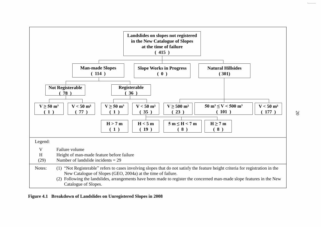
20
Man-made Slopes
( 114 )
Landslides on slopes not registered
in the New Catalogue of Slopes
at the time of failure
( 415 )
Slope Works in Progress
( 0 )
Natural Hillsides
( 301)
Not Registerable
( 78 )
Registerable
( 36 )
V ≥ 50 m³
( 1 )
V < 50 m³
( 77 )
V < 50 m³
( 35 )
V ≥ 50 m³
( 1 )
V ≥ 500 m³
( 23 )
50 m³ ≤ V < 500 m³
( 101 )
V < 50 m³
( 177 )
H > 7 m
( 1 )
H < 5 m
( 19 )
5 m ≤ H < 7 m
( 8 )
H ≥ 7 m
( 8 )
Legend:
V Failure volume
H Height of man-made feature before failure
(29) Number of landslide incidents = 29
Notes: (1) “Not Registerable” refers to cases involving slopes that do not satisfy the feature height criteria for registration in the
New Catalogue of Slopes (GEO, 2004a) at the time of failure.
(2) Following the landslides, arrangements have been made to register the concerned man-made slope features in the New
Catalogue of Slopes.
Figure 4.1 Breakdown of Landslides on Unregistered Slopes in 2008

21
the hillside, contributing to the flooding of the carpark in San Francisco Towers. The
landslide did not result in any casualty nor major consequences (such as evacuation of
residents in the nearby buildings or closure of road). However, this incident highlighted the
potential landslide hazard posed by sizeable unknown fill bodies on hillsides in urban areas.
The remaining 35 landslides were minor failures; two of them resulted in the temporary
evacuation of a squatter dwelling and a village house respectively, and one resulted in the
permanent evacuation of a squatter dwelling. The rest of the landslides did not cause any
significant impact on the community.
Following the landslides, arrangements have been made to register the concerned
man-made slope features in the New Catalogue of Slopes.
Of the 13 landslides on registered DT features, one was a major failure (about 500 m³
in volume) that occurred on slope No. 7SW-D/DT58 behind Ku Ngam Monastery, Che Kung
Miu Road (Incident No. 2008/06/0319) and the remaining 12 were minor failures with a
failure volume ranging from 2 m³ to 35 m³. Amongst these 13 landslides, one minor failure
resulted in the temporary evacuation of residents in a village house in Tseng Lan Shue, Sai
Kung and the other incidents did not have any major consequences.
4.3 Performance of Registered Man-made Slopes
4.3.1 General
The man-made slopes registered in the New Catalogue of Slopes can be broadly
classified into engineered slopes and non-engineered slopes. The performance of the
registered man-made slopes is reviewed in terms of their annual failure rates.
Engineered slopes include the following:
(a) slopes formed after 1977 (i.e. after the Geotechnical Control
Office (renamed GEO in 1991) was established) that were
designed, checked and accepted under the slope safety
system as being up to the required geotechnical standards,
(b) slopes formed before 1977 that were subsequently assessed,
checked and accepted under the slope safety system as being
up to the required geotechnical standards,
(c) slopes formed before 1977 that were subsequently upgraded,
checked and accepted under the slope safety system as being
up to the required geotechnical standards, and
(d) slope upgraded to the required geotechnical standards using
Type 3 prescriptive measures (Wong et al, 1999) under an
adequate quality system satisfying the requirements of
Environment, Transport and Works Bureau (ETWB)
Technical Circular (Works) No. 13/2005 (ETWB, 2005)
whereby checking of the design by the GEO has been waived.

22
For the present diagnosis, slopes that were not accepted under the slope safety system
(e.g. no geotechnical submissions made to the GEO for checking, or submissions with
outstanding GEO comments) are considered as non-engineered slopes.
Of the 863 genuine landslides in 2008, a total of 435 landslides (about 50%) occurred
on registered man-made slopes (Table 2.5). Of these 435 landslides, 28 (about 6.4%)
occurred on engineered slopes, comprising two major failures and 26 minor failures. The
remaining 407 landslides occurred on non-engineered slopes, comprising 31 major failures
and 376 minor failures. Further details on the landslides in 2008 involving engineered
slopes are given in Tables 4.1 and 4.2. Detailed assessment of the engineered and
non-engineered slopes is described in the sections below.
4.3.2 Landslides on Engineered Slopes
Of the 28 landslides on engineered slopes, two were major failures at Pak Fuk Road
(Incident No. 2008/06/0144) and Tsing Yi Road (Incident No. 2008/06/0188) respectively.
The major failure at Pak Fuk Road, with a failure volume of about 1,270 m³, involved mainly
an unsupported soil and rock cut slope (No. 11SE-A/C502), which was formed between 1976
and 1980 (generally referred to as an „old technology‟ slope). Another major failure
occurred on a soil and rock cut slope (No. 10NE-B/C56) at Tsing Yi Road, which involved a
wedge-type failure of about 250 m³ at the rock portion. The concerned slope had been
subjected to detailed geotechnical assessments in 1980 and 1999 respectively, but no works
were recommended to the portion that failed on 7 June 2008. The remaining 26 landslides
were minor failures, with a failure volume ranging from less than 0.1 m³ to 35 m³. Of these
26 landslides, 10 involved slopes previously treated under the LPM Programme (Tables 4.1
and 4.3).
Of the 28 landslides on engineered slopes, 10 occurred on or adjacent to the soil-nailed
portion of a slope (Table 4.1), six involved a rock cut or the rock portion of a cut slope, nine
involved unsupported cuts (Table 4.1), two occurred on soil cut slopes with a toe retaining
wall, and one occurred on a recompacted fill slope at Smithfield. The key contributory
factors to the landslides on engineered, unsupported soil cuts are summarized in Table 4.4.
The fill slope failure at Smithfield (Incident No. 2008/06/0604) was a minor failure of
about 25 m³ in volume and mainly involved the top 3 m recompacted fill layer. The
concerned fill slope (No. 11SW-A/FR1) was formed prior to 1976 across an old drainage line
and was later upgraded under the LPM Programme in 1979 by recompacting the top 3 m of
loose fill. The recompacted fill layer was underlain by loose fill of up to about 30 m in
thickness. Based on the available groundwater monitoring data prior to the 2008 landslide,
the groundwater regime at this site is complex with relatively significant storm response. In
addition, there is prima facie evidence from the previous ground investigation in 2004 that the
degree of compaction of the top 3 m recompacted fill appeared to have dropped since the
recompaction works were completed in 1979. A follow-up study is being carried out to
establish the probable causes and mechanisms of failure.
23
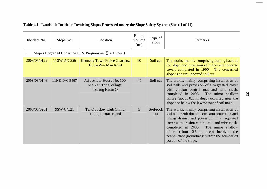
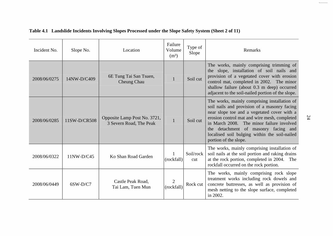
Table 4.1 Landslide Incidents Involving Slopes Processed under the Slope Safety System (Sheet 1 of 11)
Incident No. Slope No. Location
Failure
Volume
(m³)
Type of
Slope Remarks
1. Slopes Upgraded Under the LPM Programme ( = 10 nos.)
2008/05/0122 11SW-A/C256 Kennedy Town Police Quarters,
12 Ka Wai Man Road
10 Soil cut The works, mainly comprising cutting back of
the slope and provision of a sprayed concrete
cover, completed in 1990. The concerned
slope is an unsupported soil cut.
2008/06/0146 11NE-D/CR467 Adjacent to House No. 100,
Ma Yau Tong Village,
Tseung Kwan O
< 1 Soil cut The works, mainly comprising installation of
soil nails and provision of a vegetated cover
with erosion control mat and wire mesh,
completed in 2005. The minor shallow
failure (about 0.1 m deep) occurred near the
slope toe below the lowest row of soil nails.
2008/06/0201 9SW-C/C21 Tai O Jockey Club Clinic,
Tai O, Lantau Island
5 Soil/rock
cut
The works, mainly comprising installation of
soil nails with double corrosion protection and
raking drains, and provision of a vegetated
cover with erosion control mat and wire mesh,
completed in 2005. The minor shallow
failure (about 0.5 m deep) involved the
near-surface groundmass within the soil-nailed
portion of the slope.
24
Table 4.1 Landslide Incidents Involving Slopes Processed under the Slope Safety System (Sheet 2 of 11)
Incident No. Slope No. Location
Failure
Volume
(m³)
Type of
Slope Remarks
2008/06/0275 14NW-D/C409 6E Tung Tai San Tsuen,
Cheung Chau 1 Soil cut
The works, mainly comprising trimming of
the slope, installation of soil nails and
provision of a vegetated cover with erosion
control mat, completed in 2002. The minor
shallow failure (about 0.3 m deep) occurred
adjacent to the soil-nailed portion of the slope.
2008/06/0285 11SW-D/CR508 Opposite Lamp Post No. 3721,
3 Severn Road, The Peak 1 Soil cut
The works, mainly comprising installation of
soil nails and provision of a masonry facing
near slope toe and a vegetated cover with a
erosion control mat and wire mesh, completed
in March 2008. The minor failure involved
the detachment of masonry facing and
localised soil bulging within the soil-nailed
portion of the slope.
2008/06/0322 11NW-D/C45 Ko Shan Road Garden 1
(rockfall)
Soil/rock
cut
The works, mainly comprising installation of
soil nails at the soil portion and raking drains
at the rock portion, completed in 2004. The
rockfall occurred on the rock portion.
2008/06/0449 6SW-D/C7 Castle Peak Road,
Tai Lam, Tuen Mun
2
(rockfall) Rock cut
The works, mainly comprising rock slope
treatment works including rock dowels and
concrete buttresses, as well as provision of
mesh netting to the slope surface, completed
in 2002.

25
Table 4.1 Landslide Incidents Involving Slopes Processed under the Slope Safety System (Sheet 3 of 11)
Incident No. Slope No. Location
Failure
Volume
(m³)
Type of
Slope Remarks
2008/06/0604 11SW-A/FR1 Smithfield 25 Fill
The works, mainly comprising recompaction
of the top 3 m of fill, construction of a gravity
retaining wall and provision of a vegetated
cover, completed in 1979. Some works were
carried out at the fill slope under the
Smithfield Extension Project in 1996, which
did not involve any change to the slope
profile.
2008/06/0638 9SW-C/C5 Hong Kong Shaolin Martial
Art Centre, Lantau Island 1 Soil cut
The works, mainly comprising installation of
soil nails and provision of a sprayed concrete
cover to the lowest slope batter while retaining
the existing chunam surface on upper slope
batters, completed in 1990. The minor
shallow failure (about 0.3 m deep) involved
the near-surface groundmass within the
soil-nailed portion of the slope, which is
covered by chunam surface. The chunam
surface adjacent to the failed area appeared to
be poorly maintained with cracks and
unplanned vegetation.
WSD/
2008/6/20/K 11NW-B/C135
Lion Rock High Level
Fresh Water No. 1
Service Reservoir
14.4 Soil cut
The works, mainly comprising cutting back of
the slope and provision of a vegetated cover,
completed in 1992. The concerned slope is
an unsupported soil cut.

26
Table 4.1 Landslide Incidents Involving Slopes Processed under the Slope Safety System (Sheet 4 of 11)
Incident No. Slope No. Location
Failure
Volume
(m³)
Type of
Slope Remarks
2. Slopes Assessed under the LPM Programme with No Upgrading Works Required ( = 0 no.)
Nil.
3. Slopes Assessed by Studies in the Late 1970‟s to mid-1980‟s with No Upgrading Works/Further Study Required ( = 0 no.)
Nil.
4. Slopes Assessed by Government Departments and Checked by GEO with No Upgrading Works Required ( = 0 no.)
Nil.
5. Slopes Assessed by Private Owners and Checked by GEO with No Upgrading Works Required ( = 0 no.)
Nil.

27
Table 4.1 Landslide Incidents Involving Slopes Processed under the Slope Safety System (Sheet 5 of 11)
Incident No. Slope No. Location
Failure
Volume
(m³)
Type of
Slope Remarks
6. Slopes Formed or Upgraded by Government Departments and Checked by GEO ( = 10 nos.)
2008/06/0140 11NW-D/C547
Junction between
Fat Kwong Street and
Sheung Shing Street
10 Soil cut
The geotechnical design of the concerned
slope was carried out in relation to the site
formation for the Auxiliary Medical Service
Training Centre, which was checked and
accepted by the GEO in 1988. The
concerned slope is an unsupported soil cut.
2008/06/0256 7NW-B/C493
Chainage 18.5 m,
Tolo Highway (North Bound),
Tai Po
30 Soil cut
The geotechnical design of the concerned
slope was carried out in relation to the site
formation for the New Territory Trunk Road
System Project, which was checked and
accepted by the GEO in 1986. The
concerned slope is an unsupported soil cut.
2008/06/0320 7NE-A/C167 Ting Kok Road, Tai Po 20 Soil cut
The geotechnical design of the concerned
slope was carried out in relation to the Ting
Kok Road Improvement Project, which was
checked and accepted by GEO in 2002. The
minor shallow failure (about 0.5 m deep)
involved the near-surface groundmass within
the soil-nailed portion of the slope. The
failure did not cause any damage to the soil
nails and nail heads.

28
Table 4.1 Landslide Incidents Involving Slopes Processed under the Slope Safety System (Sheet 6 of 11)
Incident No. Slope No. Location
Failure
Volume
(m³)
Type of
Slope Remarks
2008/06/0419 11NW-A/C196 Near Lamp Post No. E9366,
Tai Po Road, Sham Shui Po 7
Soil/rock
cut
The geotechnical design of the concerned
slope was carried out in relation to the Tai Po
Road Improvement Project (Sha Tin to Tai
Wo Ping Interchange), which was checked
and accepted by the GEO in 1987. The
concerned slope is an unsupported soil and
rock cut.
2008/06/0450 11SE-B/C594 Hong Kong Museum of
Coastal Defence 20
Soil/rock
cut
The geotechnical design of the concerned
slope was carried out in relation to the Lei
Yue Mun Museum Project, which was
checked and accepted by the GEO in 2000.
The minor failure occurred on the steeply
inclined soil portion above the lower rock
portion and did not involve the northern
portion of the slope that was stabilised by soil
nails.
2008/06/0467 11NW-B/C89 Beacon Hill Garden,
Lung Ping Road 3 Soil cut
The concerned slope was studied under the
Phase IID Landslide Studies for Lung Cheung
Road Area by the GEO and modification
works were recommended in 1980. The
proposed works were subsequently carried out
in relation to the site formation of Tai Wo
Ping, which was checked and accepted by the
GEO in 1982. The concerned slope is an
unsupported soil cut.

29
Table 4.1 Landslide Incidents Involving Slopes Processed under the Slope Safety System (Sheet 7 of 11)
Incident No. Slope No. Location
Failure
Volume
(m³)
Type of
Slope Remarks
2008/06/0531 9SE-C/C22 Ngong Ping Road,
Ngong Ping, Lantau Island 4
Soil/rock
cut
The geotechnical design of the concerned
slope was carried out in relation to the
Improvement to Access Road to Ngong Ping
on Lantau Island, which was checked and
accepted by the GEO in 1990. The minor
shallow failure (about 1.0 m deep) occurred
near the slope toe below the lowest row of soil
nails.
2008/07/0765 11NE-D/C73 Next to Hing Tin Street,
Lam Tin 35
Soil/rock
cut
The geotechnical design of the concerned
slope was carried out in relation to the Lam
Tin Northern Link Road Project, which was
checked and accepted by the GEO in 1984.
The concerned slope is an unsupported soil
and rock cut.
WSD/
2008/6/60/K 11NW-B/C582
Shek Kip Mei No. 2
Fresh Water Service Reservoir,
West of Pak Tin Estate
7.5 Soil/rock
cut
The geotechnical design of the concerned
slope was carried out in relation to the site
formation for the Shek Kip Mei No. 2 Fresh
Water Service Reservoir, which was checked
and accepted by the GEO in 1994. The
concerned slope is an unsupported soil and
rock cut.

30
Table 4.1 Landslide Incidents Involving Slopes Processed under the Slope Safety System (Sheet 8 of 11)
Incident No. Slope No. Location
Failure
Volume
(m³)
Type of
Slope Remarks
WSD/
2008/6/8/NTW 6SE-D/C242
Yau Kam Tau No. 2
Fresh Water Service Reservoir 6 Soil cut
The geotechnical design of the concerned
slope was carried out in relation to the site
formation for the Yau Kam Tau No. 2 Fresh
Water Service Reservoir, which was checked
and accepted by the GEO in 1994. The
minor shallow failure (about 0.3 m deep)
involved the near-surface groundmass within
the soil-nailed portion of the slope.
7. Slopes Formed or Upgraded by Private Owners and Checked by GEO ( = 6 nos.)
2008/06/0144 11SE-A/C502 Pak Fuk Road
near Tin Hau Temple Road 1,270
Soil/rock
cut
The site formation plans for the private
development project of Bedford Gardens,
including the cutting back of the concerned
slope, was checked and accepted by the GCO
in 1980. The slope was handed over to the
Government in 1982. The concerned slope is
an unsupported soil and rock cut.
2008/06/0147 11SW-D/CR141 33 Shouson Hill Road 0.5 Soil/rock
cut
The geotechnical design of the concerned
slope was carried out in relation to the private
development project of 31-33 Shouson Hill
Road, which was checked and accepted by the
GEO in 1995. The minor failure occurred on
a steeply inclined soil slope portion above the
soil-nailed portion of the slope.

31
Table 4.1 Landslide Incidents Involving Slopes Processed under the Slope Safety System (Sheet 9 of 11)
Incident No. Slope No. Location
Failure
Volume
(m³)
Type of
Slope Remarks
2008/06/0188 10NE-B/C56
CLP Old Power Station
Storage Area, Tsing Yi Road,
Tsing Yi
250 Soil/rock
cut
The geotechnical assessment for the rock
slope portion (i.e. failed portion) of the
concerned slope was carried out in relation to
a Dangerous Hillside Order on the soil slope
portion, which was checked and accepted by
the GEO in 1999. The failure occurred on
the rock portion of the cut slope.
2008/06/0412 11SW-D/CR1576 8 Wong Nai Chung Road,
Wanchai 5 Soil cut
The geotechnical design of the concerned
slope was carried out in relation to the
private development project of 6-10 Wong
Nai Chung Gap Road, which was checked
and accepted by the GEO in 1987. The
failure occurred on the soil cut portion
above a retaining wall.
2008/07/0689 3SW-A/CR128
Opposite to Block 2,
Royal Knoll, 2 Chi Wing
Close,
Pak Wo Road, Fanling
3 Soil cut
The geotechnical design of the concerned
slope was carried out in relation to the
private development project of Royal Knoll,
which was checked and accepted by the
GEO in 1999. The failure occurred on the
soil cut portion above a retaining wall.
2008/07/0732 7SW-C/C62 22 Kwai Hop Street,
Kwai Shing
< 0.1
(rockfall) Rock cut
The geotechnical design of the concerned
slope was carried out in response to an
Advisory Letter, which was checked and
accepted by the GEO in 1986.

32
Table 4.1 Landslide Incidents Involving Slopes Processed under the Slope Safety System (Sheet 10 of 11)
Incident No. Slope No. Location
Failure
Volume
(m³)
Type of
Slope Remarks
8. Slopes Upgraded Following Service of DH Orders and Checked by GEO ( = 2 nos.)
2008/06/0343 11SE-A/CR279 Above North Point Methodist
Primary School,
19 Cheung Hong Street
1 Soil cut The concerned slope was upgraded by the
private owner in 2003 following the service
of a DH Order in 1998. The minor shallow
failure (about 0.3 m deep) involved the
near-surface groundmass within the
soil-nailed portion of the slope.
2008/07/0742 7SW-C/C70 Below Daughter of Mary Help
of Christians Sui Ming
Catholic Secondary School,
Kwai Hop Street, Kwai Shing
< 1 Soil/rock
cut
The concerned slope was upgraded by the
private owner in 2000 following the service
of a DH Order in 1998. The minor failure
involved the detachment of highly weathered
material on the rock portion of the slope.
9. Slopes Assessed as Not Requiring Upgrading Works But with Outstanding GEO Comments ( = 1 no.)
2008/05/0121 15NW-B/C92 Near Lei Tung Estate Bus
Terminus, Ap Lei Chau
0.5
(rockfall)
Soil/rock
cut
The rock portion (i.e. failed portion) of the
concerned slope was assessed by the Hong
Kong Housing Authority (HKHA) as not
requiring upgrading works in 2001 with
outstanding GEO comments mainly on the
geological and hydrogeological conditions of
the slope. HKHA has recently provided
GEO with supplementary information to
address the outstanding comments.

33
Table 4.1 Landslide Incidents Involving Slopes Processed under the Slope Safety System (Sheet 11 of 11)
Incident No. Slope No. Location
Failure
Volume
(m³)
Type of
Slope Remarks
10. Slopes Assessed as Requiring Upgrading Works but with Outstanding GEO Comments ( = 0 no.)
Nil.
Legend:
Landslide occurred within or adjacent to the soil-nailed portion of a cut slope ( = 10 nos.)
Landslide involved unsupported cuts ( = 9 nos.)
Notes: (1) Slopes under Categories 1 to 8 are classified as engineered slopes.
(2) Slopes under Categories 9 and 10 are post-1977 features but are not taken as engineered slopes for the purpose of this
report.

34
Table 4.2 Breakdown of Landslides on Engineered Slopes
Scale of Failure
(m³)
Fill
Slopes
Cut Slopes Retaining
Walls Total
Soil Soil/Rock Rock
> 500 m³ 0 0 (0) 1 (0) 0 0 1
50 m³ to 500 m³ 0 0 (0) 1 (0) 0 0 1
> 5 m³ to
< 50 m³ 1 6 (2) 4 (0) 0 0 11
≤ 5 m³ 0 8 (5) 5 (3) 2 0 15
Total 1 14 (7) 11 (3) 2 0 28
Legend:
6 (2) Six landslides involved engineered cut slopes, two of which occurred within
or adjacent to the soil-nailed portion of the slope
In regard to the 10 soil-nailed slope failures, all of them were associated with minor
surface erosion or small-scale detachments (≤ 20 m³) from the near-surface groundmass.
None of these failures were mobile and all had negligible consequences. Taking into
account the previously recorded failures on soil-nailed cut slopes (Ng et al, 2008a), to date no
major failures have occurred on soil-nailed cut slopes. In comparison, the failure volumes of
those landslides on engineered unsupported cuts in 2008 were generally much larger (see
Table 4.2). This affirms the robustness of soil nails for use in slope upgrading works to
prevent large-scale instability. However, minor failures often occur on soil-nailed slopes.
The number and size of these minor failures may be reduced by improved slope surface
protection and drainage measures as recommended by Ng et al (2008a).
4.3.3 Landslides on Non-engineered Slopes
There were 31 major failures on non-engineered slopes in 2008 and two of them had a
failure volume in excess of 500 m³, which were located at Wah Yan College and Shek Tsai Po
Street respectively.
The landslide at Wah Yan College (Incident No. 2008/06/0298), with a failure volume
of about 550 m³, mainly involved a natural hillside inclining at 30°, together with a 6 m high,
old masonry wall (registered as feature No. 11NW-D/R87) and the associated fill platform
behind at the mid-slope. The failure was probably caused by saturation of the groundmass
as a result of infiltration following heavy rainfall. The presence of the masonry wall and fill
platform might also have contributed to the failure.
The landslide at Shek Tsai Po Street (Incident No. 2008/06/0381), with a failure
volume of about 2,000 m³, occurred on a 55 m high soil cut slope (No. 9SW-C/C1), which
was steeply inclined at 55°. The concerned slope has a history of signs of distress and
instability (including a major failure of about 150 m³ in 1986). A Dangerous Hillside (DH)

35
Order was served in 2005 to the responsible private owners requiring them to carry out an
investigation of the stability of the concerned slope following a safety-screening study in
2002. However, the DH Order was not yet discharged at the time of the 7 June 2008
landslide.
Table 4.3 Breakdown of Landslides on Slopes Previously Treated under the LPM
Programme
Scale of Failure
(m³)
Fill
Slopes
Cut Slopes Retaining
Walls Total
Soil Soil/Rock Rock
> 500 m³ 0 0 0 0 0 0
50 m³ to 500 m³ 0 0 0 0 0 0
< 50 m³ 1 6 2 1 0 10
Total 1 6 2 1 0 10
Table 4.4 Breakdown of Key Contributory Factors to Landslides on Engineered
Unsupported Cut Slopes
Key Contributory Factors All Landslides
( = 9 nos.)
Minor Failures
( = 8 nos.)
Major Failures
( = 1 nos.)
Direct
Infiltration 4 4 0
Adverse
Geological Material 1 0 1
Adverse
Groundwater 2 1 1
Concentrated
Surface Water Flow 2 2 0
Inadequate
Geological Input 0 0 0
Inadequate
Slope Maintenance 0 0 0
Inadequate
Surface Drainage Provisions 0 0 0
Leakage of Water-carrying
Services on Slope 1 1 0
Note: A given landslide may be associated with more than one key contributory
factor to the failure.

36
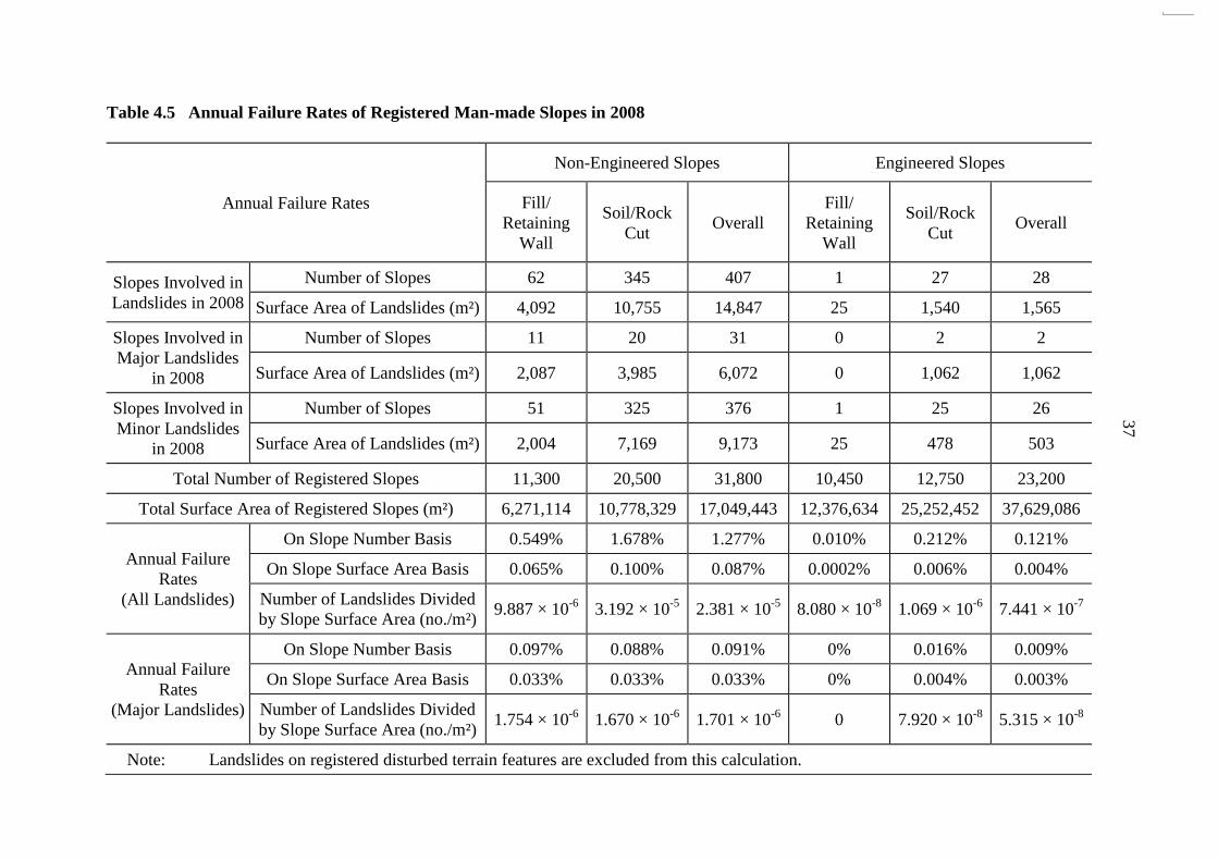
4.3.4 Annual Failure Rates
The annual failure rates of registered man-made slopes under different categories are
presented in Tables 4.5 and 4.6. The annual failure rates have been assessed in terms of:
(a) the number of landslides divided by the total number of
slopes under a given category (e.g. slope type),
(b) the surface area of landslides divided by the total surface
area of slopes under a given category, and
(c) the number of landslides divided by the total surface area of
slopes under a given category.
Relating the failure rate to the surface area of slopes, as in item (b) above, would have
taken into account that a large slope is more susceptible to having „defects‟ than a small slope.
It is however noteworthy that the annual failure rates could be influenced by other factors,
such as the rainfall characteristics, prevailing slope maintenance condition, etc.
The annual failure rates for all genuine landslides on registered man-made slopes in
2008 (excluding registered DT features) correspond to 435 / 55000 = 0.791% (number of
landslides divided by number of registered man-made slopes), 0.031% (total surface area of
landslides divided by total surface area of registered man-made slopes), and 7.955 × 10⁻⁶
(number of landslides divided by total surface area of registered man-made slopes in m²)
respectively. Further details are summarised in Table 4.6.
Based on the landslide data in 2008 (Table 4.6), the annual failure rates of engineered
slopes are lower than that of non-engineered slopes by a factor of about 11 on a slope number
basis, and about 22 on a slope surface area basis. In terms of the number of landslides per
total slope surface area, the corresponding failure rate of engineered slopes is about 32 times
lower than that of non-engineered slopes.
In addition, the annual failure rates of slopes previously treated under the LPM
Programme correspond to 0.270% (number of landslides divided by number of registered
man-made slopes treated under the LPM Programme), 0.002% (total surface area of
landslides divided by total surface area of registered man-made slopes treated under the LPM
Programme), and 1.506 × 10⁻⁶
(number of landslides divided by total surface area of
registered man-made slopes treated under the LPM Programme in m²) respectively, as
summarised in Table 4.6. In general, the annual failure rates of slopes previously treated
under the LPM Programme is lower than that of non-engineered slopes by a factor ranging
from 5 to 44, and is comparable to that of other engineered slopes
GEO‟s target annual success rates (where success rate = 1 – failure rate) for engineered
slopes are 99.8% and 99.5% against major and minor failures respectively, on the basis of the
number of landslides per total number of slopes. In 2008, the corresponding annual success
rates were 99.99% and 99.89% respectively. Hence, the targets were satisfactorily achieved.
The trend of the annual success rates of engineered slopes against major and minor failures
respectively for the period from 1997 to 2008 is shown in Table 4.7 and Figure 4.2.
37
Table 4.5 Annual Failure Rates of Registered Man-made Slopes in 2008
Annual Failure Rates
Non-Engineered Slopes Engineered Slopes
Fill/
Retaining
Wall
Soil/Rock
Cut Overall
Fill/
Retaining
Wall
Soil/Rock
Cut Overall
Slopes Involved in
Landslides in 2008
Number of Slopes 62 345 407 1 27 28
Surface Area of Landslides (m²) 4,092 10,755 14,847 25 1,540 1,565
Slopes Involved in
Major Landslides
in 2008
Number of Slopes 11 20 31 0 2 2
Surface Area of Landslides (m²) 2,087 3,985 6,072 0 1,062 1,062
Slopes Involved in
Minor Landslides
in 2008
Number of Slopes 51 325 376 1 25 26
Surface Area of Landslides (m²) 2,004 7,169 9,173 25 478 503
Total Number of Registered Slopes 11,300 20,500 31,800 10,450 12,750 23,200
Total Surface Area of Registered Slopes (m²) 6,271,114 10,778,329 17,049,443 12,376,634 25,252,452 37,629,086
Annual Failure
Rates
(All Landslides)
On Slope Number Basis 0.549% 1.678% 1.277% 0.010% 0.212% 0.121%
On Slope Surface Area Basis 0.065% 0.100% 0.087% 0.0002% 0.006% 0.004%
Number of Landslides Divided
by Slope Surface Area (no./m²) 9.887 × 10
-6 3.192 × 10
-5 2.381 × 10
-5 8.080 × 10
-8 1.069 × 10
-6 7.441 × 10
-7
Annual Failure
Rates
(Major Landslides)
On Slope Number Basis 0.097% 0.088% 0.091% 0% 0.016% 0.009%
On Slope Surface Area Basis 0.033% 0.033% 0.033% 0% 0.004% 0.003%
Number of Landslides Divided
by Slope Surface Area (no./m²) 1.754 × 10
-6 1.670 × 10
-6 1.701 × 10
-6 0 7.920 × 10
-8 5.315 × 10
-8
Note: Landslides on registered disturbed terrain features are excluded from this calculation.

38
Table 4.6 Breakdown of Annual Failure Rates of Registered Man-made Slopes
Category of Slope
Failure Rate
on Slope Number
Basis
(i.e. number of
landslides divided
by total number
of slopes)
Failure Rate
on Slope Surface
Area Basis
(i.e. surface area
of landslides
divided by total
surface area of
slopes)
Failure Rate
in Terms of
Number of
Landslides Divided
by Total Surface
Area of Slopes
(no./m²)
Registered
Man-made
Slopes
All
Landslides 0.791% 0.031% 7.955 × 10
-6
Major
Landslides 0.06% 0.013% 0.003 × 10
-6
Minor
Landslides 0.731% 0.018% 7.352 × 10
-6
Engineered
Slopes
All
Landslides
0.121%
(0.270%)
0.004%
(0.002%)
7.441 × 10⁻⁷
(1.506 × 10⁻⁶
)
Major
Landslides
0.009%
(0%)
0.003%
(0%)
5.315 × 10⁻⁸
(0)
Minor
Landslides
0.112%
(0.270%)
0.001%
(0.002%)
6.910 × 10⁻⁷
(1.506 × 10⁻⁶
)
Non-engineered
Slopes
All
Landslides
1.280%
[11 / 5]
0.087%
[22 / 44]
2.387 × 10⁻⁵
[32 / 16]
Major
Landslides 0.097% 0.033% 1.818 × 10
-6
Minor
Landslides 1.182% 0.054% 2.205 × 10
-5
Legend:
0.121% Annual failure rate of engineered slopes (considering all landslides) is 0.121%
(0.270%) and that for slopes previously treated under the LPM Programme is 0.270%.
1.277% Annual failure rate of non-engineered slopes (considering all landslides) is
[11 / 5] 1.277%, which is about 11 times and 5 times higher than those of engineered
slopes and slopes previously treated under the LPM Programme respectively.
4.4 Key Observations
4.4.1 Severity of Rainstorms that Triggered Landslides Involving Man-made Slopes
Studies of seven landslides involving man-made slopes have been carried out and the
findings provide sufficiently reliable information to assess the timing and severity of the
rainstorms preceding the failures for six cases, with the exception for one where the timing of

39
failure was unknown. Of these six landslide studies, the rainfall analyses show that 4 of
them occurred during a rainstorm, which was virtually the most severe that the slope had
experienced in the past. The remaining two landslides, one of which was the fatal landslide
at Cafeteria Old Beach and the other was the major failure on the hillside below Broadwood
Road overlooking San Francisco Towers (see Section 4.2.2), occurred during a rainstorm that
was less severe than the previous major rainstorms. Further details on the fatal landslide at
Cafeteria Old Beach are given below.
The fatal landslide at Cafeteria Old Beach (Incident No. 2008/06/0129) occurred on slope
No. 6SW-C/CR797 at about 6:30 a.m. on 7 June 2008, involving the collapse of about 25 m
length of an approximately 2.8 m high crest concrete retaining wall and part of the slope below.
The landslide debris, with a failure volume of about 300 m³, hit a squatter structure at the toe of
the slope and resulted in two fatalities. The investigation (FSWJV, 2009) established that the
landslide was principally caused by build-up of transient groundwater pressure in the groundmass
following the heavy rainfall. One of the probable factors contributing to the failure was the
adverse change to the site setting due to the extensive vegetation clearance on the platform at the
crest of slope No. 6SW-C/CR797, about 6 to 18 months prior to the failure. This would have
promoted water ingress through direct infiltration as well as local ponding on the platform,
rendering the slope more susceptible to rain-induced failure.
On the basis of the observations from landslide studies, the proposition that the
continued stability of an existing man-made slope may be proven by past severe rainstorms
should be treated with extreme caution. Before one could confidently count on past slope
performance regarding the margin of safety for long-term stability, one needs to consider
factors such as potential adverse changes to the environmental conditions, adequacy of
regular slope maintenance, as well as possible slope deterioration and progressive slope
deformation during past rainstorms.
4.4.2 Comparison of Rainfall and Landslide History between Two Significant
Rainstorms in August 2005 and June 2008
The rainstorm events of August 2005 and June 2008 had resulted in extensive
landslides and a few casualties. The rainfall and landslide data for the two events, together
with that for the July 1994 event, are summarised in Table 3.1. A comparison of the rainfall
and landslide history of the 1994 and 2005 rainstorm events had been made in
Tam et al (2008). The two rainstorm events in 2005 and 2008 are compared below.
Comparing the LPI of the two respective rainstorm events, the August 2005 rainstorm has a lower
LPI of 10, compared with a LPI value of 12 for the June 2008 event (Figure 3.1). The total
number of reported landslides in the June 2008 rainstorm was about 60% more than that in the
August 2005 rainstorm, probably because of the more intense short-duration and 24-hour rainfall
of the former. However, the number of major, man-made slope failures triggered by the August
2005 rainstorm was 50, about 2.5 times more than that triggered by the June 2008 rainstorm
(Table 3.1). This may have been due to the different locations of the peak rainfalls from the
respective rainstorms (Figures 4.3 and 4.4). For the August 2005 event (Figure 4.3), the peak
rainfall mainly affected the urban fringe areas near Shatin and Tsuen Wan. This had resulted in
a relatively high number of major landslides on man-made slopes, about half of which were of
low consequence-to-life (CTL) (i.e. CTL Category 3) as many were located in urban fringe areas.

40
Table 4.7 Annual Success Rates of Engineered Slopes from 1997 to 2008
Scale of Failure
Annual Success Rate on Slope Number Basis
(i.e. number of landslides divided by total number of slopes)
1997 1998 1999 2000 2001 2002 2003 2004 2005 2006 2007 2008
Engineered Slopes
Processed by the
Slope Safety
System
(≥ 50 m³)
99.97% 99.98% 99.97% 99.98% 99.98% 100% 99.99% 100% 99.98% 100% 100% 99.99%
Engineered Slopes
Processed by the
Slope Safety
System
(< 50 m³)
99.89% 99.92% 99.92% 99.91% 99.93% 99.95% 99.95% 99.97% 99.89% 99.95% 99.97% 99.89%
Note: See Figure 4.2 for a plot of annual success rates of engineered slopes against the target annual success rates from 1997 and
2008.

41
99.99100
99.97 99.98 99.9799.98 99.98
100 99.99 10099.98
100
99.8999.95
99.89
99.9799.9599.95
99.9399.9199.9299.92
99.89
99.97
99.45
99.50
99.55
99.60
99.65
99.70
99.75
99.80
99.85
99.90
99.95
100.00
100.05
1996 1997 1998 1999 2000 2001 2002 2003 2004 2005 2006 2007 2008 2009
Year
Annual
Succ
ess
Rat
e (
% )
Target annual success rate for engineered slopes against major failures (i.e. 99.8%)
Target annual success rate for engineered slopes against minor failures (i.e. 99.5%)
99.80
99.50
Legend:
Annual success rate for engineered slopes against major failures
Annual success rate for engineered slopes against minor failures
Target annual success rate for engineered slopes against major failures (i.e. 99.8%)
Target annual success rate for engineered slopes against minor failures (i.e. 99.5%)
Figure 4.2 Annual Success Rates of Engineered Slopes from 1997 to 2008
99.99
99.88
10099.98
10099.9910099.9899.98
99.9799.98
99.97
100
99.97
99.89
99.92 99.9299.91
99.9399.95 99.95
99.97
99.89
99.95
99.45
99.50
99.55
99.60
99.65
99.70
99.75
99.80
99.85
99.90
99.95
100.00
100.05
1996 1997 1998 1999 2000 2001 2002 2003 2004 2005 2006 2007 2008 2009
Year
An
nu
al
Su
ccess
Rate
( %
)
Annual success rate for engineered slopes against major landslides
Annual success rate for engineered slopes against minor landslides
Target annual success rate for engineered slopes with no major landslides
Target annual success rate for engineered slopes with no minor or major landslides
99.80
99.50
99.99
99.88
10099.98
10099.9910099.9899.98
99.9799.98
99.97
100
99.97
99.89
99.92 99.9299.91
99.9399.95 99.95
99.97
99.89
99.95
99.45
99.50
99.55
99.60
99.65
99.70
99.75
99.80
99.85
99.90
99.95
100.00
100.05
1996 1997 1998 1999 2000 2001 2002 2003 2004 2005 2006 2007 2008 2009
Year
Annual
Success
Rate
( %
)
Annual success rate for engineered slopes against major landslides
Annual success rate for engineered slopes against minor landslides
Target annual success rate for engineered slopes with no major landslides
Target annual success rate for engineered slopes with no minor or major landslides
99.80
99.50
99.99
99.88
10099.98
10099.9910099.9899.98
99.9799.98
99.97
100
99.97
99.89
99.92 99.9299.91
99.9399.95 99.95
99.97
99.89
99.95
99.45
99.50
99.55
99.60
99.65
99.70
99.75
99.80
99.85
99.90
99.95
100.00
100.05
1996 1997 1998 1999 2000 2001 2002 2003 2004 2005 2006 2007 2008 2009
Year
Annual S
uccess R
ate ( %
)
Annual success rate for engineered slopes against major landslides
Annual success rate for engineered slopes against minor landslides
Target annual success rate for engineered slopes with no major landslides
Target annual success rate for engineered slopes with no minor or major landslides
99.80
99.50
99.99
99.88
10099.98
10099.9910099.9899.98
99.9799.98
99.97
100
99.97
99.89
99.92 99.9299.91
99.9399.95 99.95
99.97
99.89
99.95
99.45
99.50
99.55
99.60
99.65
99.70
99.75
99.80
99.85
99.90
99.95
100.00
100.05
1996 1997 1998 1999 2000 2001 2002 2003 2004 2005 2006 2007 2008 2009
Year
An
nu
al S
uccess R
ate ( %
)
Annual success rate for engineered slopes against major landslides
Annual success rate for engineered slopes against minor landslides
Target annual success rate for engineered slopes with no major landslides
Target annual success rate for engineered slopes with no minor or major landslides
99.80
99.50

42
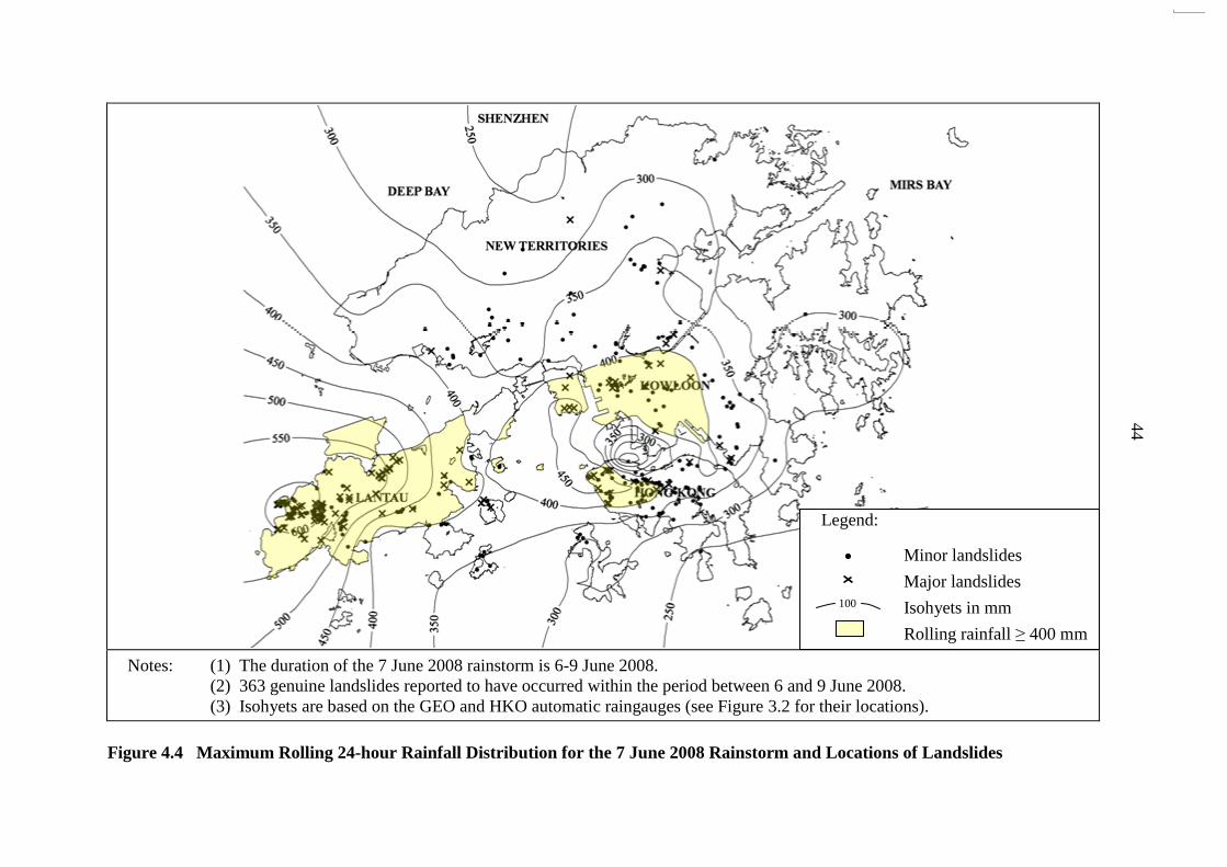
In regard to the June 2008 rainstorm, the peak rainfall occurred largely on the rural
areas on western Lantau Island (Figure 4.4). Consequently, there were many more natural
terrain landslides and more reported major landslides (84 nos.) involving natural hillsides than
that (20 nos.) from the August 2005 rainstorm (Table 3.1). Many of them had high mobility
and affected roads and developments. The relatively high debris mobility in the June 2008
landslides may have been partly caused by the intense short-duration rainfall of the June 2008
rainstorm that was more severe than that of the August 2005 event, e.g. the highest recorded
1-hour and 4-hour rolling rainfall in the June 2008 rainstorm were about twice of those in the
August 2005 rainstorm (Table 3.1).
4.4.3 Landslides with Inadequate Slope Maintenance Diagnosed as a Key Contributory
Factor to Failure
All the 435 landslides on registered man-made slopes were reviewed to assess whether
inadequate slope maintenance was likely to have been a key contributory factor to the failures.
Reference has been made to the records of emergency inspections by the GEO or other
Government departments, inspections of selected landslides by the LI consultants, together
with the findings of the follow-up studies.
Inadequate slope maintenance was assessed to be a key contributory factor in 28 of the
435 landslides reviewed (i.e. about 6.4%), which comprises one major failure on an old soil
cut slope at Creasy Road (Incident No. 2008/06/0151) with a failure volume of about 50 m³
and another 27 minor failures with a failure volume ranging from less than 1 m³ to 30 m³.
Amongst these 27 minor failures, 3 occurred on engineered slopes.
Of these 28 landslides involving inadequate slope maintenance, 16 affected
Government slopes and 4 affected private slopes (of which one of them was the major failure
at Creasy Road). The remaining eight affected features of mixed maintenance responsibility
of Government/private, based on the information from the Slope Maintenance Responsibility
Information System (SMRIS) maintained by the Lands Department. Of the eight incidents
that occurred on slope features with mixed maintenance responsibility, five were on the
Government portion, two were on the private portion, and one involved both the Government
and private portions of the feature.
It should be noted that the number of incidents with inadequate slope maintenance is
relatively small and hence they are unlikely to be of statistical significance. Nevertheless,
the above diagnosis re-affirms the importance of regular slope maintenance. It also serves as
a reminder that even an engineered slope is liable to fail without adequate maintenance.
4.4.4 Landslides Affecting Squatters
In 2008, there were 65 landslide incidents, 12 of which were major failures, affecting
registered squatter dwellings (i.e. those included in the 1982 Housing Department‟s Squatter
Structure Survey (GEO, 2004b)). Of these landslides, 24 had resulted in notable
consequence, including the temporary evacuation of 28 registered squatter dwellings and
compulsory clearance (i.e. Category 1 Non-Development Clearance (NDC)) recommended
for 39 registered squatter dwellings (Table 2.3). These landslide incidents highlighted that

43
Notes: (1) The duration of the 20 August 2005 rainstorm is 16-21 August 2005.
(2) 229 genuine landslides reported to have occurred within the period between 16 and 21 August 2005.
(3) Isohyets are based on the GEO and HKO automatic raingauges (see Figure 3.2 for their locations).
Figure 4.3 Maximum Rolling 24-hour Rainfall Distribution for the 20 August 2005 Rainstorm and Locations of Landslides
Legend:
Minor landslides
Major landslides
Isohyets in mm
Rolling rainfall ≥ 400 mm
100
44
Notes: (1) The duration of the 7 June 2008 rainstorm is 6-9 June 2008.
(2) 363 genuine landslides reported to have occurred within the period between 6 and 9 June 2008.
(3) Isohyets are based on the GEO and HKO automatic raingauges (see Figure 3.2 for their locations).
Figure 4.4 Maximum Rolling 24-hour Rainfall Distribution for the 7 June 2008 Rainstorm and Locations of Landslides
Legend:
Minor landslides
Major landslides
Isohyets in mm
Rolling rainfall ≥ 400 mm
100

45
some squatter dwellings were subject to relatively high landslide risk. To address the
landslide risk arising from Government man-made slopes affecting squatter dwellings, the
current approach to deal with the risk by means of clearing the affected squatter dwellings has
been enhanced whereby slope upgrading works would also be undertaken as part and parcel
of a multi-pronged approach to manage the landslide risk.
4.4.5 Natural Terrain Landslides
4.4.5.1 Overview
The June 2008 rainstorm had triggered many sizeable natural terrain landslides.
Amongst the reported landslides on natural hillsides, about 41% (124 nos.) were major
failures, compared to that about 6% (35 nos.) of the reported landslides on man-made slopes
were major failures.
Natural terrain landslides in 2008 had caused significant impact to the community.
Many of the reported natural terrain landslides involved sizeable debris flows with a long
runout distance affecting nearby facilities. In 2008, the reported natural terrain landslides
accounted for about 92% of the cases involving evacuation or closure of houses or flats
affected by landslides. About 63% of the number of squatter dwellings evacuated as a result
of landslides were due to natural hillside failures. Moreover, about half of the number of
road closures arising from landslides were due to natural hillside failures.
Many of the reported natural terrain landslides occurred on hillsides with a history of
past instabilities. Some of the landslides were very sizable, involving large-scale and highly
mobile debris flows with unexpected runout paths occasionally. The scale, mobility and
runout characteristics of debris flows will be studied separately. The study will also cover
the large number of natural terrain landslides (more than 2,000) triggered by the June 2008
rainstorm, which were not reported to the Government as they occurred in remote areas and
did not affect any major facilities.
4.4.5.2 Large-scale Landslides
The 7 June 2008 rainstorm triggered many sizeable natural terrain landslides, three of
which have been selected for follow-up studies. These landslides included the one that
occurred on the hillside behind Hong Kong University (HKU) (Incident No. 2008/06/0193),
one in catchment No. 30 above Yu Tung Road (Incident No. 2008/06/0344) and another
above Shatin Pass Road (Incident No. 2008/06/0170). The failure volumes for the HKU, Yu
Tung Road and Shatin Pass Road landslides were in the order of 1,700 m³ (for the primary
landslide source area), 2,400 m³ and 3,000 m³ respectively. In these landslides, the debris
entered into a nearby drainage line and developed into a large-scale debris flow, with a runout
distance up to about 600 m.
The HKU and Yu Tung Road landslides involved shallow failures of about 3 m deep,
and were largely within the surface mantle of colluvium or talluvium. The shallow failures
are typically triggered by slope saturation and build-up of transient water pressure as a result
of infiltration and subsurface seepage flow.

46
In both the HKU and Yu Tung Road landslides, the failures were spatially extensive,
measuring up to about 30 m wide and 50 long, and occurring at relatively steep parts of the
hillside. The HKU landslide occurred at a location where a large area of accumulation of
colluvial deposits had been formed over time as a result of relatively frequent, moderate scale
landslide activities in the past (Figures 4.5 and 4.6). Similarly, the Yu Tung Road landslide
occurred where large areas of boulderly deposits had accumulated (Figures 4.7 and 4.8), as a
result of landsliding activities, together with general mass wasting processes. In both cases,
the scale of the failures appears to have been influenced by the presence and deterioration of
the accumulated debris and site topography, together with the characteristics of the
7 June 2008 rainstorm.
For the landslide at Shatin Pass Road, the rupture surface was partially controlled by
an adversely orientated joint within the weathered rock, with evidence of retrogressive
enlargement of the main scarp after the initial failure. This has resulted in a relatively deep,
up to 6 m, and sizeable failure, measuring up to about 30 m wide by 50 m long. The
possible build-up of transient cleft water pressure in the rock joints as a result of infiltration
may have also contributed to the failure. The mechanism of failure at Shatin Pass Road was
different from that at HKU and Yu Tung Road that largely involved the surface deposits with
relatively minor influence from the underlying weathered rock mass.
4.4.5.3 Presence of Recent Debris Fans
In the Yu Tung Road debris flow case, the 1945 and 1963 aerial photographs show a
distinct and relatively more recent debris fan at the outlet of the main drainage line in
catchment No. 30, as evidenced by the hummocky surface and different vegetation type
compared with other parts of the debris fan. This more recent debris fan had possibly been
formed as a result of a single large failure, with an estimated volume in the order of about
3,000 m³, comparable with the scale of the June 2008 failure from the same catchment.
The presence of a relatively more recent debris fan could be a “tell-tale” sign of a
potentially “active” drainage line with respect to channelised debris flow. However, such
debris fans do not provide any indication of the likely frequency of a significant debris flow
event. Moreover, the identification of such debris fans in urban areas from aerial
photographs may be difficult, as the debris deposits in such areas would likely have been
removed or substantially disturbed by the developments prior to any aerial photograph records.
Further, the presence of debris fans may be related to fluvial deposition instead of past
failures.
4.4.6 Landslides on Hillside Pockets Close to Developments in Urban Areas
In 2008, some landslides occurred on hillside pockets close to developments in urban
areas, and three of them have been identified as major failures and affecting residential
buildings. Amongst these three major failures, one notable landslide (Incident No.
2008/06/0156) occurred on 7 June 2008 on the hillside behind Rockwin Court, Fung Fai
Terrace, Happy Valley (Figure 4.9). The estimated failure volume was 500 m³. Some
landslide debris travelled down to the rear garden of Rockwin Court and went into the flats
of Rockwin Court adjacent to the toe of the hillside. Residents in nine affected flats of

47
Figure 4.5 Location Plan of the 7 June 2008 Landslide on the Hillside behind HKU

48
Notes: (1) The figure is based on the 1963 aerial photograph No. Y07601.
(2) See Figure 4.5 for the approximate extent of area shown in this figure.
Figure 4.6 Accumulation of Colluvial Deposits on the Hillside behind HKU
N
The 7 June 2008
landslide scar
Convex break-in-
slope above the
landslide scar Colluvial
accumulation
from previous
failure(s)
Ephemeral
drainage lines
Landslide
catchment

49
Figure 4.7 Location Plan of the 7 June 2008 Landslides on the Hillside above
Yu Tung Road

50
Notes: (1) The figure is based on the 1963 aerial photograph No. Y06358.
(2) See Figure 4.7 for the approximate extent of area shown in this figure.
Figure 4.8 Area of Boulderly Deposits on the Hillside above Yu Tung Road
Concave break-in-slope
above the landslide scar
The 7 June 2008 landslide scar
in catchment No. 30
Boulderly deposits
N
Perennial drainage line
in catchment No. 30

51
Rockwin Court were temporarily evacuated. The incident did not result in any casualties.
The concerned hillside, which is situated below Stubbs Road overlooking Rockwin Court
(Figure 4.10), is steeply inclined at about 40° and densely vegetated. The hillside
catchment is a relatively small catchment with a plan area of about 1,100 m² and measures
about 35 m wide and 30 m long. According to the GEO‟s Landslide Database and
Enhanced Natural Terrain Landslide Inventory (ENTLI), there are no records of previous
landslides on the concerned hillside.
Another major failure (Incident No. 2008/06/0159) occurred on 7 June 2008 on the
hillside below Keng Hau Road, Tai Wai, involving a failure volume of about 220 m³. The
incident resulted in the temporary evacuation of the residents from three houses at the crest of
the concerned hillside.
The above incidents, together with the landslide on the hillside below Broadwood
Road (see Section 4.2.2), highlighted the potential landslide hazard posed by the hillsides that
are close to developments in urban areas and the severe consequences in the event of a failure.
By nature of their location, these hillsides may have been subjected to human disturbance and
there may be a potential link between the stability of these hillsides and the surrounding
man-made features (e.g. roads, surface drainage provisions, etc.).
4.4.7 Coverage of the Historical Landslide Catchment Inventory
Among the 301 reported natural terrain landslides in 2008, 175 (58%) of them
occurred within 50 m of at least 1 ENTLI feature and 39 (13%) were within the existing
Historical Landslide Catchments (HLCs). A total of 16 HLCs involved were ranked 300
or below, which included some of the highest ranked catchments in the HLC Inventory
(HLCI). Some of the reported natural terrain landslides were not covered by the existing
HLCI because the concerned hillside catchments did not affect any important facilities or
the known historical landslides occurred at some distance from the facilities.
5 Proposed Improvement Initiatives
Improvement initiatives were proposed by Ng et al (2008b) following a review of the
landslides that occurred in 2007. The progress of the follow-up actions is summarised in
Table 5.1.
Based on the present review, the following improvement initiatives are proposed:
(a) carry out a review of landslide data to assess the
performance of recompacted fill slopes and identify factors
that affect their performance (Section 4.3.2),
(b) continue to study natural terrain landslides to improve
understanding of hillside failures, debris mobility and
tell-tale signs of potentially active drainage lines
(Section 4.4.5), and

52
Figure 4.9 Location Plan of the 7 June 2008 Landslide behind Rockwin Court, Fung
Fai Terrace

53
Note: Indicative slope boundaries (yellow broken lines) are based on pre-landslide
records in the GEO‟s Slope Information System.
Figure 4.10 Overall Setting of the Hillside behind Rockwin Court, Fung Fai Terrace
The 7 June 2008
landslide scar
Stubbs Road
Rockwin Court
11SW-D/F69
11SW-D/C12
11SW-D/C1162
11SW-D/C14
Celeste Court
11SW-D/R1118
11SW-D/C2237
The 7 June 2008 landslide

54
Table 5.1 Progress of Follow-up Actions on the Improvement Measures Recommended
in the Review of 2007 Landslides
Recommended Improvement Measures Progress
1. Develop a methodology for carrying out
systematic inspections of hillsides affected
by major hill fires to check for possible
presence of distress that may pose a threat to
existing development.
The draft methodology was completed.
A pilot trial is being carried out for
completion by end-2009.
2. Review the landslide history and
performance of private man-made slopes
previously subjected to „No Further Action
(NFA)‟ recommendations following
safety-screening studies.
A screening exercise was carried out,
which identified 19 man-made slopes
with occurrence of landslide after an
NFA recommendation was made in
safety-screening studies. Of the 19
slopes, there was only one landslide
with a failure volume > 50 m³, which
occurred on slope No. 6SW-C/CR797 at
Cafeteria Old Beach. The rest were
generally minor failures, partly caused
by inadequate slope maintenance. The
necessary follow-up actions for the 19
slopes had been completed.
Action completed.
3. Clarify the objective and nature of
safety-screening studies in the relevant GEO
Circular and GEO Information Notes.
The main objective of safety-screening
studies is to establish whether a prima
facie case exists for serving a Dangerous
Hillside Order under the Buildings
Ordinance requiring the responsible
owners to carry out an investigation of a
private slope feature. A
safety-screening study, normally without
ground investigation, is not a detailed
investigation to confirm whether or not
the slope feature meets the current safety
standards.
GEO Circular No. 30 (GEO, 2009b) and
GEO Information Note No. 01/2009
(GEO, 2009c) have been revised by
CGE/SS to provide the necessary
clarification in regard to the objective
and nature of safety-screening studies.
Action completed.

55
(c) develop a methodology for the identification of sizeable fill
bodies and hillside pockets in developed areas that may pose
a significant landslide hazard to the community
(Section 4.4.6).
6 Conclusions
Based on the overall diagnostic landslide review presented in this report, the following
observations are made with respect to the performance of the Government‟s slope safety
system:
(a) The annual failure rates of major and minor landslides on
engineered slopes, on a slope number basis, were 0.009%
and 0.112% respectively in 2008. The pledged annual
success rates of 99.8% and 99.5% of engineered slopes in
preventing major and minor landslides, respectively, were
met.
(b) Overall, 99.88% of the engineered slopes performed
satisfactorily without the occurrence of any landslides in
2008.
A number of initiatives have been proposed, as detailed in Section 5 of this report,
with a view to further improving the slope engineering practice and enhancing the slope
safety system in Hong Kong.
7 References
ETWB (2005). Prescriptive Measures for Stabilisation and Improvement of Man-made
Slopes and Standardised Debris-resisting Barriers for Mitigation of Natural Terrain
Landslide Hazards. Technical Circular (Works) No. 13/2005, Environment,
Transport and Works Bureau, Hong Kong, 7 p.
FSWJV (2009). Report on the Landslide at Cafeteria Old Beach of 7 June 2008.
Geotechnical Engineering Office, Hong Kong, 122 p.
GEO (2004a). Registration and Upgrading of Records of Features. GEO Circular No. 15,
Geotechnical Engineering Office, Hong Kong, 20 p.
GEO (2004b). Non Development Clearance (Slope Safety) of Squatters. GEO Circular No.
3, Geotechnical Engineering Office, Hong Kong, 16 p.
GEO (2009a). Landslide Potential Index. GEO Information Note No. 3/2009,
Geotechnical Engineering Office, Hong Kong, 4 p.

56
GEO (2009b). Stage 1 and Stage 2 Study of Slopes and Retaining Walls. GEO Circular
No. 30, Geotechnical Engineering Office, Hong Kong, 6 p.
GEO (2009c). Dangerous Hillside Order. GEO Information Note No. 01/2009,
Geotechnical Engineering Office, Hong Kong, 6 p.
Lam, C.L.H, Lau, J.W.C. & Chan, H.W. (2009). Factual Report on Hong Kong Rainfall
and Landslides in 2008. Special Project Report No. SPR 2/2009, Geotechnical
Engineering Office, Hong Kong, 225 p.
Ng, A.F.H., Lau, T.M.F., Shum, K.W. & Cheung, W.M. (2008a). Review of Selected
Landslides Involving Soil-nailed Slopes. GEO Report No. 222, Geotechnical
Engineering Office, Hong Kong, 98 p.
Ng, A.F.H., Lau, J.W.C. & Lau, T.M.F. (2008b). Review of Landslides in 2007. Landslide
Study Report No. LSR 4/2008, Geotechnical Engineering Office, Hong Kong, 41 p.
SSTRB (2009). Report on the 18th
Meeting of the Slope Safety Technical Review Board.
Report No. 18, Slope Safety Technical Review Board, Geotechnical Engineering
Office, Hong Kong, 45 p.
Tam, S.M., Lau, T.M.F., Ng, A.F.H. & Kong, H.S.W. (2008). Review of Landslides in 2005.
GEO Report No. 220, Geotechnical Engineering Office, Hong Kong, 53 p.
Wong, C.K.L. (1998). The New Priority Classification Systems for Slopes and Retaining
Walls. GEO Report No. 68, Geotechnical Engineering Office, Hong Kong, 117 p.
Wong, H.N. (2009). Rising to the Challenges of Natural Terrain Landslides. Proceedings
of the HKIE Geotechnical Division’s Annual Seminar 2009 on Natural Hillsides:
Study and Risk Mitigation Measures, Hong Kong, pp. 15-53.
Wong, H.N., Pang, L.S., Wong, A.C.W., Pun, W.K. & Yu, Y.F. (1999). Application of
Prescriptive Measures to Slopes and Retaining Wall (2nd Edition).
GEO Report No. 56, Geotechnical Engineering Office, Hong Kong, 73 p.

57
Appendix A
Factors Affecting the Performance of Man-made Slopes

58
Contents
Page
No.
Contents 58
A.1 Introduction 59
A.2 Factors GEO Can Influence 59
A.3 Factors Out of the Control of GEO 59
A.4 Factors Affecting Slope Safety System 60

59
A.1 Introduction
A review of landslides in 2008, together with selected landslides in recent years, has
been carried out to identify factors that could affect slope performance, as well as the possible
enhancement measures. Factors that GEO can influence and those that are out of GEO‟s
control have been separated to help assess the uncertainties. Other factors that may have an
impact on the performance of the slope safety system are also discussed. The key findings
of the review are presented below.
A.2 Factors GEO Can Influence
The factors that could affect the performance of man-made slopes and that GEO can
influence are listed as follows:
(a) poor workmanship (e.g. inadequate compaction for fill
slopes),
(b) inadequate site control (e.g. carrying out earthworks during
wet season, inadequate temporary drainage provisions or
inadequate temporary support/protection during
construction),
(c) inadequate design consideration (e.g. design with low
robustness, inadequate engineering geological input, poor
drainage detailing),
(d) adverse change in site setting (e.g. replacement of hard
surface cover on slopes by vegetated cover),
(e) adverse effects of trees or vegetation on slope stability (e.g.
tree root wedging effects), and
(f) inadequate maintenance of water-carrying services (e.g.
leakage or overspill).
The above factors generally involve engineering practice and standards. This calls
for a need to continually review relevant technical guidelines and standards (e.g. GEO‟s
Technical Guidance Notes) and regularly update them to promulgate the findings and lessons
learnt from landslide investigations. The findings and lessons learnt should also be
promulgated to the practitioners through technical workshops, seminars and publication of
technical papers from time to time.
A.3 Factors Out of the Control of GEO
The factors that could affect the performance of man-made slopes and that are out of
GEO‟s control are listed as follows:

60
(a) earthquake,
(b) extreme rainfall due to climate change,
(c) slope deterioration,
(d) adverse changes to environmental condition and slope
setting (e.g. illegal cultivation, illegal dumping of
construction waste, unauthorised construction, uncontrolled
vegetation clearance, etc.),
(e) inadequate slope maintenance, including the absence of a
legal mandatory requirement for private slope maintenance,
(f) inadequate design and maintenance of drainage systems,
and uncontrolled overland flow from adjacent facilities, and
(g) adverse geological and/or hydrogeological conditions.
To address the above issues, a range of public education activities have been launched
to raise the community‟s awareness on slope safety and related safety precautionary measures.
In addition, a high-level central emergency control system has recently been established to
strengthen the Government‟s emergency management, preparedness and response in dealing
with natural disasters including major landslide incidents.
A.4 Factors Affecting Slope Safety System
In addition to the factors identified above, other factors that may affect the
performance of the slope safety system have been identified as follows:
(a) delay in undertaking the necessary slope upgrading or
improvement works, and
(b) slope features not fully addressed in the existing slope safety
system.
Based on past experience, the necessary slope upgrading or improvement works could
be delayed due to objection by residents to the works or objection to the road closure required
for carrying out the slope works, etc. Uncertainties in the maintenance responsibility of the
slopes would also delay the works. As a result, the necessary slope upgrading or
improvement works could not be carried out in a timely manner.
In 2008, a number of major failures occurred on hillside pockets close to developments
in urban areas (see Section 4.4.6). These slope features are not covered under the existing
slope safety system and hence would not be subject to any systematic action.

GEO PUBLICATIONS AND ORDERING INFORMATION土力工程處刊物及訂購資料
A selected list of major GEO publications is given in the next page. An up-to-date full list of GEO publications can be found at the CEDD Website http://www.cedd.gov.hk on the Internet under “Publications”. Abstracts for the documents can also be found at the same website. Technical Guidance Notes are published on the CEDD Website from time to time to provide updates to GEO publications prior to their next revision.
部份土力工程處的主要刊物目錄刊載於下頁。而詳盡及最新的
土力工程處刊物目錄,則登載於土木工程拓展署的互聯網網頁
http://www.cedd.gov.hk 的“刊物”版面之內。刊物的摘要及更新
刊物內容的工程技術指引,亦可在這個網址找到。
Copies of GEO publications (except geological maps and other publications which are free of charge) can be purchased either by:
讀者可採用以下方法購買土力工程處刊物(地質圖及免費刊物除外):
Writing toPublications Sales Section,Information Services Department,Room 402, 4th Floor, Murray Building,Garden Road, Central, Hong Kong.Fax: (852) 2598 7482
書面訂購
香港中環花園道
美利大廈4樓402室
政府新聞處
刊物銷售組
傳真: (852) 2598 7482
or- Calling the Publications Sales Section of Information Services Department (ISD) at (852) 2537 1910- Visiting the online Government Bookstore at http:// www.bookstore.gov.hk- Downloading the order form from the ISD website at http://www.isd.gov.hk and submitting the order online or by fax to (852) 2523 7195- Placing order with ISD by e-mail at [email protected]
或
- 致電政府新聞處刊物銷售小組訂購 (電話:(852) 2537 1910)- 進入網上「政府書店」選購,網址為
http://www.bookstore.gov.hk- 透過政府新聞處的網站 (http://www.isd.gov.hk) 於網上遞交
訂購表格,或將表格傳真至刊物銷售小組 (傳真:(852) 2523 7195)- 以電郵方式訂購 (電郵地址:[email protected])
1:100 000, 1:20 000 and 1:5 000 geological maps can be purchased from:
讀者可於下列地點購買1:100 000、1:20 000及1:5 000地質圖:
Map Publications Centre/HK,Survey & Mapping Office, Lands Department,23th Floor, North Point Government Offices,333 Java Road, North Point, Hong Kong.Tel: (852) 2231 3187Fax: (852) 2116 0774
香港北角渣華道333號
北角政府合署23樓
地政總署測繪處
電話: (852) 2231 3187傳真: (852) 2116 0774
Requests for copies of Geological Survey Sheet Reports and other publications which are free of charge should be directed to:
如欲索取地質調查報告及其他免費刊物,請致函:
For Geological Survey Sheet Reports which are free of charge:Chief Geotechnical Engineer/Planning,(Attn: Hong Kong Geological Survey Section)Geotechnical Engineering Office,Civil Engineering and Development Department,Civil Engineering and Development Building,101 Princess Margaret Road,Homantin, Kowloon, Hong Kong.Tel: (852) 2762 5380Fax: (852) 2714 0247E-mail: [email protected]
免費地質調查報告:
香港九龍何文田公主道101號
土木工程拓展署大樓
土木工程拓展署
土力工程處
規劃部總土力工程師
(請交:香港地質調查組)電話: (852) 2762 5380傳真: (852) 2714 0247電子郵件: [email protected]
For other publications which are free of charge:Chief Geotechnical Engineer/Standards and Testing,Geotechnical Engineering Office,Civil Engineering and Development Department,Civil Engineering and Development Building,101 Princess Margaret Road,Homantin, Kowloon, Hong Kong.Tel: (852) 2762 5346Fax: (852) 2714 0275E-mail: [email protected]
其他免費刊物:
香港九龍何文田公主道101號
土木工程拓展署大樓
土木工程拓展署
土力工程處
標準及測試部總土力工程師
電話: (852) 2762 5346傳真: (852) 2714 0275電子郵件: [email protected]

MAJOR GEOTECHNICAL ENGINEERING OFFICE PUBLICATIONS土力工程處之主要刊物
GEOTECHNICAL MANUALS
Geotechnical Manual for Slopes, 2nd Edition (1984), 302 p. (English Version), (Reprinted, 2011).斜坡岩土工程手冊(1998),308頁(1984年英文版的中文譯本)。Highway Slope Manual (2000), 114 p.
GEOGUIDES
Geoguide 1 Guide to Retaining Wall Design, 2nd Edition (1993), 258 p. (Reprinted, 2007).Geoguide 2 Guide to Site Investigation (1987), 359 p. (Reprinted, 2000).Geoguide 3 Guide to Rock and Soil Descriptions (1988), 186 p. (Reprinted, 2000).Geoguide 4 Guide to Cavern Engineering (1992), 148 p. (Reprinted, 1998).Geoguide 5 Guide to Slope Maintenance, 3rd Edition (2003), 132 p. (English Version).岩土指南第五冊 斜坡維修指南,第三版(2003),120頁(中文版)。Geoguide 6 Guide to Reinforced Fill Structure and Slope Design (2002), 236 p.Geoguide 7 Guide to Soil Nail Design and Construction (2008), 97 p.
GEOSPECS
Geospec 1 Model Specification for Prestressed Ground Anchors, 2nd Edition (1989), 164 p. (Reprinted, 1997).
Geospec 3 Model Specification for Soil Testing (2001), 340 p.
GEO PUBLICATIONS
GCO PublicationNo. 1/90
Review of Design Methods for Excavations (1990), 187 p. (Reprinted, 2002).
GEO PublicationNo. 1/93
Review of Granular and Geotextile Filters (1993), 141 p.
GEO PublicationNo. 1/2006
Foundation Design and Construction (2006), 376 p.
GEO PublicationNo. 1/2007
Engineering Geological Practice in Hong Kong (2007), 278 p.
GEO PublicationNo. 1/2009
Prescriptive Measures for Man-Made Slopes and Retaining Walls (2009), 76 p.
GEO PublicationNo. 1/2011
Technical Guidelines on Landscape Treatment for Slopes (2011), 217 p.
GEOLOGICAL PUBLICATIONS
The Quaternary Geology of Hong Kong, by J.A. Fyfe, R. Shaw, S.D.G. Campbell, K.W. Lai & P.A. Kirk (2000), 210 p. plus 6 maps.The Pre-Quaternary Geology of Hong Kong, by R.J. Sewell, S.D.G. Campbell, C.J.N. Fletcher, K.W. Lai & P.A. Kirk (2000), 181 p. plus 4 maps.
TECHNICAL GUIDANCE NOTES
TGN 1 Technical Guidance Documents