Embed Size (px)
Citation preview
Earth-Science Reviews 139 (2014) 317–335
Contents lists available at ScienceDirect
Earth-Science Reviews
j ourna l homepage: www.e lsev ie r .com/ locate /earsc i rev
Review of ten years of volcano deformations recorded by theground-based InSAR monitoring system at Stromboli volcano:a tool to mitigate volcano flank dynamics and intense volcanic activity
Federico Di Traglia a,b, Teresa Nolesini a,⁎, Emanuele Intrieri a, Francesco Mugnai a, Davide Leva c,Mauro Rosi b, Nicola Casagli a
a Dipartimento di Scienze della Terra, Università di Firenze, Via La Pira 4, Firenze, Florence, Italyb Dipartimento di Scienze della Terra, Università di Pisa, Via Santa Maria 53, Pisa, Italyc Ellegi s.r.l. – LiSALab, via Petrarca 55, Rovello Porro, Como, Lombardy, Italy
⁎ Corresponding author.E-mail address: [email protected] (T. Nolesini).
http://dx.doi.org/10.1016/j.earscirev.2014.09.0110012-8252/© 2014 Elsevier B.V. This is an open access art
a b s t r a c t
a r t i c l e i n f oArticle history:Received 10 April 2014Accepted 26 September 2014Available online 6 October 2014
Keywords:Volcano deformationGBInSARVolcano monitoringStromboli volcanoFlank volcano dynamicsTsunamogenic landslide
Stromboli volcano (Southern Italy) is one of the most monitored volcano in the world with a surveillance net-work that includes a permanently sited ground-based SAR interferometer (GBInSAR). This work is the reviewof the GBInSAR data gained from the last decade of monitoring activity. The analysis of the entire dataset ofGBInSAR measurements allowed the assessment of the deformation field of the northern part of the summitcrater area and the Sciara del Fuoco depression. In detail, the main displacements recognized can be related todifferent factors: 1) the inflation/deflation respectively immediately before and after each new effusive event;2) the bulging of localized sectors of the volcano involved in the vent opening; 3) the gravitational sliding ofthe Sciara del Fuoco infill; 4) the movement of lava flows. Accelerations in this sector are related to sheet intru-sions, while the possibility of vent opening, associatedwith small sliding, or catastrophic flank failure are relatedto highly overpressurized sheets, able to produce high displacement rate in the Sciara del Fuoco.In the summit crater area, the increases in the displacement rate are related to the pressurization of the shallowconduit system, as the consequence of the variation in the magma level (magmastatic pressure) or to the lateralmagma migration (lateral conduit expansion or dike intrusion) in response to the increase of the overpressurecomponent. Fluctuations in the displacement rate in the summit crater area can be related to the magmaoverturning within the conduit, with the increases in displacement rate during the upwelling of less densemagma, while displacement rate decreases as the degassed magma column is pushed out from the conduit(lava flows or overflows). Instead, the decrease in the displacement rate without coeval lava outpouring couldbe related to the sink of the degassed magma due to density contrast between the gas-poor and the gas-charged magmas. Using the displacement rate in the summit crater area as a proxy for the variation in thepressure condition in conduit (both magmastatic and overpressure components), thresholds for the crises char-acterized by the occurrence of overflows (eventually associated with major explosions) and flank effusions(eventually associated with paroxysmal explosions) are identified. Small conduit overpressure will produceoverflows (sometimes associated with crater-rim collapses), while large magma overpressure will laterallyexpand the conduit forming NE-SW striking sheets, feeding eruptive vents at the base of the summit craterarea and within the Sciara del Fuoco, generating conditions of instability that can evolve into catastrophiccollapse of the instable flank.
© 2014 Elsevier B.V. This is an open access article under the CC BY-NC-SA license(http://creativecommons.org/licenses/by-nc-sa/4.0/).
Contents
1. Introduction . . . . . . . . . . . . . . . . . . . . . . . . . . . . . . . . . . . . . . . . . . . . . . . . . . . . . . . . . . . . . . 3182. Geological and volcanological setting . . . . . . . . . . . . . . . . . . . . . . . . . . . . . . . . . . . . . . . . . . . . . . . . . . 318
2.1. Geological outlines . . . . . . . . . . . . . . . . . . . . . . . . . . . . . . . . . . . . . . . . . . . . . . . . . . . . . . . 3182.2. Volcanic activity at Stromboli volcano . . . . . . . . . . . . . . . . . . . . . . . . . . . . . . . . . . . . . . . . . . . . . . . 321
3. Materials and methods: the GBInSAR monitoring system at Stromboli volcano . . . . . . . . . . . . . . . . . . . . . . . . . . . . . . . . 322
icle under the CC BY-NC-SA license (http://creativecommons.org/licenses/by-nc-sa/4.0/).

318 F. Di Traglia et al. / Earth-Science Reviews 139 (2014) 317–335
4. Monitored sectors . . . . . . . . . . . . . . . . . . . . . . . . . . . . . . . . . . . . . . . . . . . . . . . . . . . . . . . . . . . 3225. The 2002–2013 eruptive crises . . . . . . . . . . . . . . . . . . . . . . . . . . . . . . . . . . . . . . . . . . . . . . . . . . . . . 323
5.1. 2002–03 crisis . . . . . . . . . . . . . . . . . . . . . . . . . . . . . . . . . . . . . . . . . . . . . . . . . . . . . . . . . . 3235.2. 2004–2006 crises . . . . . . . . . . . . . . . . . . . . . . . . . . . . . . . . . . . . . . . . . . . . . . . . . . . . . . . . 3255.3. 2007 crisis . . . . . . . . . . . . . . . . . . . . . . . . . . . . . . . . . . . . . . . . . . . . . . . . . . . . . . . . . . . 3255.4. 2008–2013 crises . . . . . . . . . . . . . . . . . . . . . . . . . . . . . . . . . . . . . . . . . . . . . . . . . . . . . . . . 326
6. Discussions . . . . . . . . . . . . . . . . . . . . . . . . . . . . . . . . . . . . . . . . . . . . . . . . . . . . . . . . . . . . . . 3286.1. Slope instability of the Sciara del Fuoco . . . . . . . . . . . . . . . . . . . . . . . . . . . . . . . . . . . . . . . . . . . . . . 3286.2. Structural framework of the summit area . . . . . . . . . . . . . . . . . . . . . . . . . . . . . . . . . . . . . . . . . . . . . 3296.3. Changing in eruption intensity at Stromboli volcano . . . . . . . . . . . . . . . . . . . . . . . . . . . . . . . . . . . . . . . . 3316.4. The GBInSAR monitoring system: a tool for mitigating the risk connected with intense eruptive activity and flank dynamics at Stromboli volcano . 331
7. Conclusions . . . . . . . . . . . . . . . . . . . . . . . . . . . . . . . . . . . . . . . . . . . . . . . . . . . . . . . . . . . . . . 332Acknowledgments . . . . . . . . . . . . . . . . . . . . . . . . . . . . . . . . . . . . . . . . . . . . . . . . . . . . . . . . . . . . . . 332References . . . . . . . . . . . . . . . . . . . . . . . . . . . . . . . . . . . . . . . . . . . . . . . . . . . . . . . . . . . . . . . . . 333
1. Introduction
Since the 2002–03 flank effusion, characterized by a tsunamogeniclandslide provoked by the intrusion of a dyke in the Sciara del Fuoco(SdF), together with a paroxysmal explosion (Rosi et al., 2006; Neriet al., 2008), Stromboli became one of the most monitored volcano inthe world with a progressive improvement of the surveillance network(Barberi et al., 2009), comprising 13 broadband digital seismometers(Giudicepietro et al., 2009), tiltmeters (Bonaccorso et al., 2009), an auto-mated distancemeasuring station (Puglisi et al., 2005), a continuous GPSnetwork (Mattia et al., 2004), two strainmeters (Bonaccorso et al., 2012),a network of visual and thermal cameras (Bonaccorso et al., 2012),magnetic and gravity stations (Carbone et al., 2012), a permanent sideGround-based Interferometric Synthetic Aperture Radar (GBInSAR;Antonello et al., 2004), 4 seismo-acoustic stations (Goto et al., 2014), asystem of optical radiometers and infrared and visible light camerasand a geochemical network for the automatic monitoring of the SO2
flux (Burton et al., 2009) and the CO2/SO2 ratio of the crater gas plume(Aiuppa et al., 2009), the CO2 soil flux and the dissolved CO2 in the ther-malwaterwells (Inguaggiato et al., 2011). TheGBInSAR is, so far, theonlyexample in the literature of such technology applied to the surveillanceof an active volcano. It is used for landslide monitoring in the area ofthe Sciara del Fuoco (Casagli et al., 2010; Intrieri et al., 2013; Nolesiniet al., 2013), coupled with the automated distance measuring station(Bonforte et al., 2008), and formonitoring inflation-deflation of the sum-mit crater area that can reveal any change in the volcanic activity (Casagliet al., 2009; Di Traglia et al., 2013, 2014a,b). It is considered as the bestway to capture short, subtle episodes of conduit pressurization in openvent volcanoes like Stromboli (Chris Newhall, pers. comm.). Stromboliis an open-conduit volcano and does not experience pressurization ofthe magma storage and/or plumbing system that produces ground de-formations at the scale of the volcanic edifice. For any such system, local-ized inflation or deflation may occur in response to conduit processes,such as magma convection and uprising (Bonaccorso and Davis, 1999;Chaussard et al., 2013). Detectable ground deformation at Strombolihas only been observed in association with dyke intrusion at shallowdepth, prior to the opening of new eruptive fractures (Bonaccorso,1998; Bonaccorso et al., 2008; Casagli et al., 2009).
Stromboli (Fig. 1) is one of the most well-known volcanoes in theworld and its persistent activity, consisting of frequent, small scale, ex-plosions gave its name to Strombolian activity (Blackburn et al., 1976).Intrusion-related landslides from the NW unstable flank of the volcano(the Sciara del Fuoco depression; Fig. 1b) are also frequent (Barberiet al., 1993; Di Roberto et al., 2008, 2010; Rosi et al., 2013) and are themost hazardous phenomena, due to their tsunamogenic potential(Fig. 2; Tinti et al., 2005; Nave et al., 2010; Nolesini et al., 2013).Tsunamis have occurred numerous times in recent centuries and canaffect large areas of the coast of Stromboli (Barberi et al., 1993; Tintiet al., 2005; Rosi et al., 2013 and references therein). However, the
most frequent hazards at Stromboli are related to the occurrence ofhigher-intensity Strombolian explosions (paroxysmal or major explo-sion, based on the scale of the main blast; Barberi et al., 1993). Paroxys-mal events affected large zones and produced bombs and blocks thatreached inhabited areas (mainly to Ginostra village in the SW part ofthe Island) and hot avalanches that caused fatalities (i.e. 1930 paroxysm;Bertagnini et al., 2011; Di Roberto et al., 2014).
Stromboli volcano is constantly erupting, with temporal andspatial changes in frequency, intensity, and nature of the activity(see, e.g., Taddeucci et al., 2013). Giving the persistent activity atStromboli, we prefer to use the term "crisis" instead of "eruption"to describe period characterized by volcanic activity with intensityhigher than the "ordinary" strombolian activity. The term "crisis" ismore appropriate in the case of Stromboli because it has civilprotection implications. A single crisis comprises different phe-nomena, such as higher-intensity strombolian explosions, lavaoverflows, major explosions, flank effusions and/or paroxysmal ex-plosions. The large number of crises characterized by higher-intensity volcanic activity that occurred at Stromboli since the2002–03 crisis has offered a unique opportunity to improve our un-derstanding of how the volcano works. This study is an attempt toelaborate the 10-years-long GBInSAR time series in order to evalu-ate flank dynamics (and in particular the occurrence of intrusion-related landslides) and the occurrence of higher-intensity volcanicactivity at Stromboli, providing an operative tool to mitigate theireffects.
2. Geological and volcanological setting
2.1. Geological outlines
The 916 m-high Stromboli Island is the emerged portion of a~3000 m-high volcano located in the north-eastern tip of the AeolianArchipelago, in the southern Tyrrhenian Sea (Fig. 1a). The rock compo-sition varies between basaltic andesite, shoshonite and latite-trachyte(e.g. Hornig-Kjarsgaard et al., 1993), with the oldest exposed productsdated approximately 100 ka (Gillot and Keller, 1993).
Based on the presence of structural unconformities and changes inrock composition, the volcanic sequence of the subaerial cone has beensubdivided into five periods of activity (Rosi, 1980; Hornig-Kjarsgaardet al., 1993; Keller et al., 1993; Tibaldi et al., 2008; Calvari et al., 2011c;Vezzoli et al., 2014): 1) Paleostromboli I (Cavoni synthem; 85–64 ka);2) Paleostromboli II and Paleostromboli III (Gramigna synthem; 64–26 ka); 3) Lower, Middle and Upper Vancori (Frontone and Vancorisynthems; 26–13 ka); 4) Neostromboli (Fossetta synthem; 13–6 ka);5) Recent Stromboli (Pizzo, Fili di Baraona and Sciara synthems;6 ka-present day activity).
Stromboli volcano was affected by three caldera collapses and atleast five sector collapse events, which were followed by
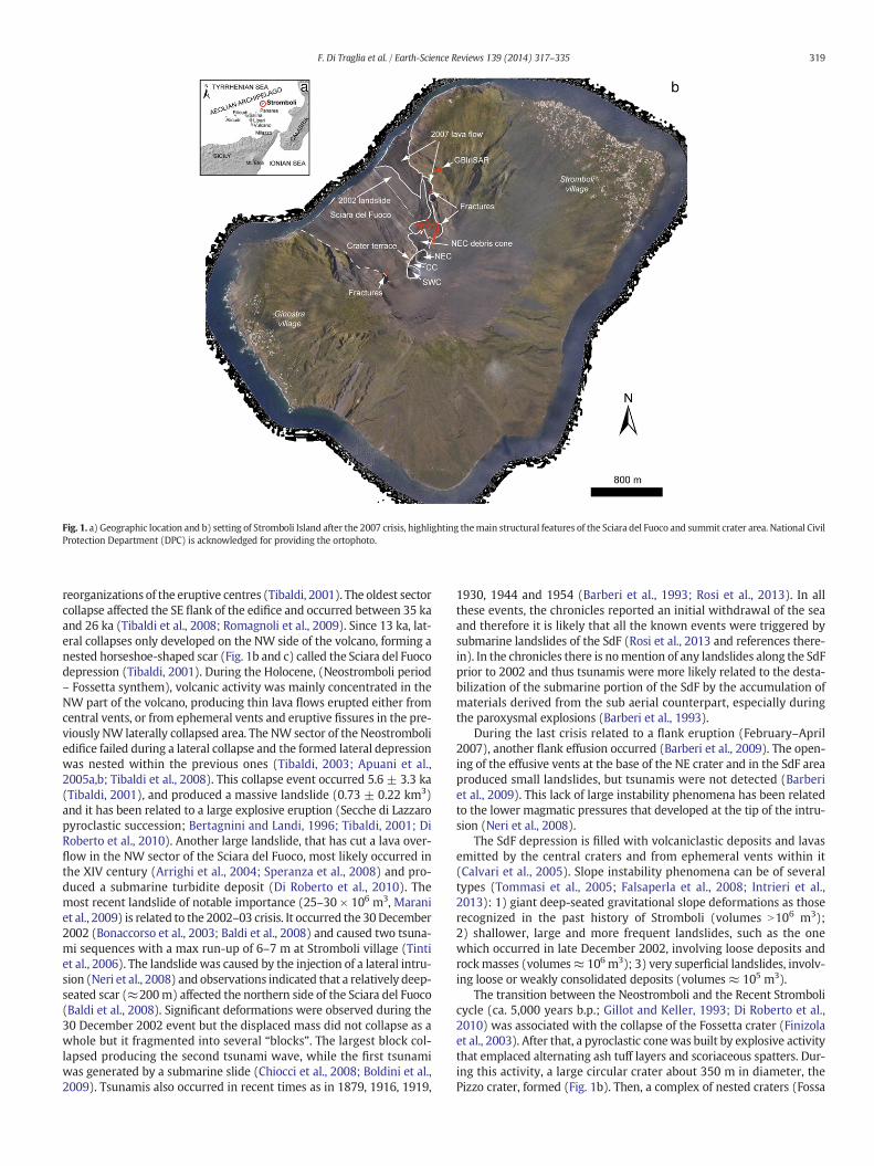
Fig. 1. a) Geographic location and b) setting of Stromboli Island after the 2007 crisis, highlighting themain structural features of the Sciara del Fuoco and summit crater area. National CivilProtection Department (DPC) is acknowledged for providing the ortophoto.
319F. Di Traglia et al. / Earth-Science Reviews 139 (2014) 317–335
reorganizations of the eruptive centres (Tibaldi, 2001). The oldest sectorcollapse affected the SE flank of the edifice and occurred between 35 kaand 26 ka (Tibaldi et al., 2008; Romagnoli et al., 2009). Since 13 ka, lat-eral collapses only developed on the NW side of the volcano, forming anested horseshoe-shaped scar (Fig. 1b and c) called the Sciara del Fuocodepression (Tibaldi, 2001). During the Holocene, (Neostromboli period– Fossetta synthem), volcanic activity was mainly concentrated in theNW part of the volcano, producing thin lava flows erupted either fromcentral vents, or from ephemeral vents and eruptive fissures in the pre-viously NW laterally collapsed area. The NW sector of the Neostromboliedifice failed during a lateral collapse and the formed lateral depressionwas nested within the previous ones (Tibaldi, 2003; Apuani et al.,2005a,b; Tibaldi et al., 2008). This collapse event occurred 5.6 ± 3.3 ka(Tibaldi, 2001), and produced a massive landslide (0.73 ± 0.22 km3)and it has been related to a large explosive eruption (Secche di Lazzaropyroclastic succession; Bertagnini and Landi, 1996; Tibaldi, 2001; DiRoberto et al., 2010). Another large landslide, that has cut a lava over-flow in the NW sector of the Sciara del Fuoco, most likely occurred inthe XIV century (Arrighi et al., 2004; Speranza et al., 2008) and pro-duced a submarine turbidite deposit (Di Roberto et al., 2010). Themost recent landslide of notable importance (25–30 × 106 m3, Maraniet al., 2009) is related to the 2002–03 crisis. It occurred the 30December2002 (Bonaccorso et al., 2003; Baldi et al., 2008) and caused two tsuna-mi sequences with a max run-up of 6–7 m at Stromboli village (Tintiet al., 2006). The landslide was caused by the injection of a lateral intru-sion (Neri et al., 2008) and observations indicated that a relatively deep-seated scar (≈200m) affected the northern side of the Sciara del Fuoco(Baldi et al., 2008). Significant deformations were observed during the30 December 2002 event but the displaced mass did not collapse as awhole but it fragmented into several “blocks”. The largest block col-lapsed producing the second tsunami wave, while the first tsunamiwas generated by a submarine slide (Chiocci et al., 2008; Boldini et al.,2009). Tsunamis also occurred in recent times as in 1879, 1916, 1919,
1930, 1944 and 1954 (Barberi et al., 1993; Rosi et al., 2013). In allthese events, the chronicles reported an initial withdrawal of the seaand therefore it is likely that all the known events were triggered bysubmarine landslides of the SdF (Rosi et al., 2013 and references there-in). In the chronicles there is nomention of any landslides along the SdFprior to 2002 and thus tsunamis were more likely related to the desta-bilization of the submarine portion of the SdF by the accumulation ofmaterials derived from the sub aerial counterpart, especially duringthe paroxysmal explosions (Barberi et al., 1993).
During the last crisis related to a flank eruption (February–April2007), another flank effusion occurred (Barberi et al., 2009). The open-ing of the effusive vents at the base of the NE crater and in the SdF areaproduced small landslides, but tsunamis were not detected (Barberiet al., 2009). This lack of large instability phenomena has been relatedto the lower magmatic pressures that developed at the tip of the intru-sion (Neri et al., 2008).
The SdF depression is filled with volcaniclastic deposits and lavasemitted by the central craters and from ephemeral vents within it(Calvari et al., 2005). Slope instability phenomena can be of severaltypes (Tommasi et al., 2005; Falsaperla et al., 2008; Intrieri et al.,2013): 1) giant deep-seated gravitational slope deformations as thoserecognized in the past history of Stromboli (volumes N106 m3);2) shallower, large and more frequent landslides, such as the onewhich occurred in late December 2002, involving loose deposits androckmasses (volumes≈ 106 m3); 3) very superficial landslides, involv-ing loose or weakly consolidated deposits (volumes ≈ 105 m3).
The transition between the Neostromboli and the Recent Strombolicycle (ca. 5,000 years b.p.; Gillot and Keller, 1993; Di Roberto et al.,2010) was associated with the collapse of the Fossetta crater (Finizolaet al., 2003). After that, a pyroclastic conewas built by explosive activitythat emplaced alternating ash tuff layers and scoriaceous spatters. Dur-ing this activity, a large circular crater about 350 m in diameter, thePizzo crater, formed (Fig. 1b). Then, a complex of nested craters (Fossa

Fig. 2. a) Volcanic activity at Stromboli volcano since 1900 (data from Barberi et al., 1993; Rosi et al., 2013); b) volcanic and tsunami hazardmap at Stromboli Island (modified after Naveet al., 2010 and Rosi et al., 2013). Zone 1: it is the zone around the active craters. It is exposed to hazard at any time, because of the possibility of a sudden blast from an obstructed(reopened) vent. The area is frequently affected by fallout of blocks and bombs (large, hot or cold rock fragments) ejected during the normal explosive activity. Zone 2: This zone maybe affected by ballistic ejecta during major explosions (and paroxysms). Toxic gases may reach here troublesome concentrations. The Sciara del Fuoco, exposed to tephra (ash and rockfragments) fallout, landslide and lava flow hazard, is included in this zone. Zone 3: it is a zone intermediate between the one exposed to risk for major explosions (Zone 2) and themuch larger one thatmay be affected during paroxysms (Zone 4). Its width varies as a function of the energy of explosive events. From the historical data the lower limit can be reasonablyplaced at the elevation of 400 m. During major explosions, this zone is affected by fallout of ash, lithic ejecta and incandescent lava fragments, with development of fires. Dangerous ac-cumulation of ash, as well as ash avalanchesmay occur on the steep slopes. Zone 4: it is the zone affected by tephra (ash and rock fragments) fallout in case of a large, paroxysmal eruption.Ash showers, episodically accompanied by the fall of large blocks or bombs (hot or cold rock fragments), with fires and roof collapses, are the expected hazards. Breathingmay be difficultin case of wind-driven dense ash and gas laden steam clouds. Zone 5: it is the safest zone of Stromboli where only minor ash showers may occur. The low coasts may be affected by smalltsunamis. Tsunami high risk area: area to be left immediately during threat of a tsunami, such as when the sirens sound or the sea retreats (Nave et al., 2010).
320 F. Di Traglia et al. / Earth-Science Reviews 139 (2014) 317–335

321F. Di Traglia et al. / Earth-Science Reviews 139 (2014) 317–335
crater, 1930 crater, 1954 crater, 2002–03 crater; Finizola et al., 2003)later opened within the Pizzo crater. It comprises the Large and theSmall Fossa craters, respectively about 280 and 150 m in diameter(Finizola et al., 2003). The presently summit active cone is a compositepyroclastic cone, elongated NE-SW, where three main craters can berecognized (SW, central, and NE). Finizola et al. (2002), revealed thepresence of a continuous impermeable layer at a constant depth(≈200 m), likely represented by crushed material rich in hydratedand altered minerals such as clay, that could represent the slidingplane of the type 2 SdF landslides.
2.2. Volcanic activity at Stromboli volcano
The ‘ordinary’ Strombolian activity consists of passive magmadegassing alternated to brief (a few to few tens of s), 100- to 200-mhigh scoria-rich jets produced by explosions of variable energy every10–20 min (Patrick et al., 2007; Andronico et al., 2008; Taddeucciet al., 2012), classified as having a Volcanic Explosive Index (VEI;Newhall and Self, 1982) within the −7/–3 range (Houghton et al.,2013).
This activity is occasionally interrupted by explosive events withhigher intensity than the ordinary activity at Stromboli (Barberi et al.,1993; Rosi et al., 2013), defined as ‘paroxysmal’ (VEI = 0/1) and‘major’ (VEI = −2/−1; Fig. 3) explosions, considered as the twohigher-intensity ‘variations on the Strombolian theme’ (Rosi et al.,2000; Hougthon and Gonnermann, 2008; Del Bello et al., 2012). Ordi-nary activity is fed by high-porphyritic (HP), volatile-poor magma,while during paroxysmal and major explosions low-porphyritic
Fig. 3.Diagrammatic representation of a) eruptive activity and b) ground deformation at Stromb2002 tsunamigenic landslides; d) 5 April 2003 paroxysm; e) lava flow in the Sciara del Fuoco a
(LP), volatile-rich magma is ejected (Landi et al., 2008; Bertagniniet al., 2011; La Felice and Landi, 2011). Even though they have verysimilar characteristics in the hand specimen, LP clasts of major andparoxysmal explosion show different textural features (Pioli et al.,2014). The LP clasts erupted during the paroxysmal explosion repre-sent magma batches derived from the deeper reservoir beneathStromboli (max. 4 km), while LP magma erupted during the majorexplosions represents the feeding zone of the HP reservoir, whichis continuously hybridized by regular arrivals of the deep-derivedmagmas (Pioli et al., 2014).
The ordinary activity is produced once a gas slug – a discrete volumeof gas rising in the conduit systemat a relatively higher velocitywith re-spect to the surrounding mafic magma – reaches the cooled upper sur-face of a magma column causing its raising, up-doming and ultimatelythe explosive release of gas that is accompanied by the ejection ofmagma clots (Blackburn et al., 1976; Vergniolle and Brandeis, 1996;Parfitt, 2004; Hougthon and Gonnermann, 2008). The bursting ofoverpressured slugs has been invoked as a general mechanism toexplain the entire spectrum of eruptive dynamics at Stromboli (Allard,2010; Del Bello et al., 2012). Ordinary activity is associated with arelatively shallow origin of the gas source (800–2700 m Burton et al.,2007a), while major and paroxysmal explosions are related to largergas slugs that are in equilibrium with the magma at depth greaterthan 4 km below the crater terrace (Allard, 2010; Métrich et al., 2010;Aiuppa et al., 2011). These may be the depth of slug formations, evenif recent studies (Rivalta et al., 2013) revealed the possibility that thedelay in vesiculation can occur in mafic, low-porphyritic magmas,altering the actual depth of slug formation.
oli in theperiodDecember 2002–May2013; c) Sciara del Fuoco area after the 30Decemberrea during the 2007 flank eruption crisis.

322 F. Di Traglia et al. / Earth-Science Reviews 139 (2014) 317–335
Paroxysmal explosions are often associated with flank effusiveeruptions (Calvari et al., 2011b), which are almost anticipated bymajor changes in the activity of the volcano (Lautze and Houghton,2005; Rosi et al., 2006; Pistolesi et al., 2008, 2011; Andronico et al.,2013) and hence their occurrence can be estimated (Casagli et al.,2009; Calvari et al., 2011a; Inguaggiato et al., 2011). The 5 April 2003and the 15 March 2007 paroxysmal explosions took place when athreshold lava volume (~4.0 × 10⁶ m3) was erupted, implying that par-oxysmal events can occur after the start of an apparently gentle effusiveeruption (Calvari et al., 2011b).
Only a few precursors have been revealed for major explosions(Aiuppa et al., 2011; Di Traglia et al., 2013). In general, major explosionsare clustered in a relatively short time period (1–2 months) of ‘anoma-lous’ activity during which the ‘ordinary’ Strombolian activity is charac-terized by more frequent events (N5 events per hour, Andronico et al.,2008; Taddeucci et al., 2013), by formation of a cool crust in one of thecraters (Calvari et al., 2011a; Gurioli et al., 2014), by high CO2 soil andplumefluxes (N1000 tonsper day, Aiuppa et al., 2011), by high displace-ment rate in the crater area (Di Traglia et al., 2013, 2014a,b) and they aregenerally associated with the emission of lava from the summit craters(Rosi et al., 2013).
3. Materials and methods: the GBInSAR monitoring system atStromboli volcano
The GBInSAR consists of a ground-based interferometer (Fig. 4a, b)producing 1 SAR image every 11 min of the NE flank of the crater areaand the upper part of the SdF. Radar images are obtained through sam-pling techniques, so frequency and spatial steps have to be selected inorder to avoid ambiguity in range and cross-range (Antonello et al.,2004). The system is able to measure line-of-sight (LoS) grounddisplacement in the time interval between two acquisitions and thedisplacement is calculated from the phase difference between theback-scattered signals received at different times, through the cross-correlation between two SAR images. Interferometric analysis allowsus to derive the displacement field of the observed portion of the SdFand of the crater area in the elapsed time. Negative and positive valuesof displacement indicate, respectively, a movement towards or awayfrom the sensor. Since the GBInSAR is located in a stable area north ofthe SdF, and its LoS allows us to detect theN-S components of themove-ments in all direction (Fig. 4c); negative displacementmay represent in-flation of the crater area of the volcanoor inflation and sliding of the SdF,while positive displacement may represent deflation of the crater area(Casagli et al., 2009). Range and cross-range resolution are on average
Fig. 4. The GBInSAR system in the a) 2003 and b) 2009; c) GBInSAR cumulative d
2 m × 2 m, with a measurement precision referred to the displacementof less than 1 mm (Casagli et al., 2009). The displacement rate is the re-sult of the mathematical division between the displacement measuredin an interferogram (referred to the difference between two SAR im-ages) and the elapsed time between the two images. The key conceptof the GBInSAR data analysis is the elapsed time between the two SARimages used to create interferograms, allowing the identification ofvery low displacement rates (0.01–0.001 mm/h) related to the creepof the northern sector of the SdF (Intrieri et al., 2013; Nolesini et al.,2013) or very fast displacement rates (up to 300 mm/h) associatedwith effusive vent opening (Casagli et al., 2009). The capabilityof InSAR to detect ground displacement depends on the persistenceof phase coherence over appropriate time intervals (Lu et al., 2002).Loss in coherence mainly depends on chaotic ground movements(Antonello et al., 2004), e.g. grain avalanches. A coherence mask(threshold = 0.8) is set to mask the noisy areas of the interferogram(Luzi et al., 2010). The phase values can be affected by ambiguity(unwrapped phase) but, due to the short elapsed time (11 min) be-tween two subsequent measurements on Stromboli volcano, the inter-ferometric displacements are usually smaller than half wavelengthand unwrapping procedures (as described by Ghiglia and Romero,1994) are not necessary.
The data presented in this review cover the entire 10 years ofmonitoring even if the system has undergone a few stops due tomalfunctions and maintenance (2005–2006: Fig. 3).
4. Monitored sectors
Throughout the first months of data recording, it was possible to de-fine two zones with different movements: the SdF and the NE craterarea. After the 2007 crisis, the analysis of the displacements has beenperformed by dividing the part of the volcano monitored by theGBInSAR into 5 regions (Fig. 1): 1) the crater rim of the NE cone;2) the flanks of the crater area; 3) the slope at the base of the NE pyro-clastic cone; 4) the portion of the SdF within the 2002 tsunamigeniclandslide (α landslide; Tommasi et al., 2005); 5) a small portion of theSdF outside of the 2002 tsunamigenic landslide.
Sector 1 is a small area at 750m a.s.l., corresponding to the rim of theNE crater area, characterized by low coherence of the GBInSAR signaldue to the fast and continuous remobilization of the products ejectedby the crater. High displacement rates have been detected in shorttemporal baseline interferograms (11 minutes–1 hour). The geometryof the displacement reveals the presence of unstable materials on the
isplacement map (2010–2013) highlighting sensor the Field of View (FOV).

323F. Di Traglia et al. / Earth-Science Reviews 139 (2014) 317–335
outer slope downhill the rimof theNE crater,with peaks in thedisplace-ment rate up to 30 mm/h.
Sector 2 corresponds to the external flank of the crater terrace and itis positioned on the Recent Stromboli deposits (Keller et al., 1993)mainly characterized by scoria products and thin lava flows (Tibaldiet al., 2008). Sector 2 is characterized by two types of displacements:i) long-lived movements, which have maximum displacement at theboundary between sector 2 and 3 (Fig. 5), and ii) short-living move-ments, interpreted as syn-explosive deformations linked to higher-intensity explosions (Tarchi et al., 2008; Di Traglia et al., 2013).
Sector 3 corresponds to the slope at the base of the NE pyroclasticcone, just below sector 1. The location of the maximum displacementsin sector 3 changed with time, affecting areas at different elevation(Fig. 5), between 700 m and 600 m a.s.l..
Sector 4 corresponds to the upper part of the 2002 landslide (α land-slide in Tommasi et al., 2005), which occurred on the 30 December2002 at the beginning of the 2002–2003 crisis (Intrieri et al., 2013).This sector is characterized by a scar produced by a retrogressivelandslide that occurred soon after the eccentric vent opening at400 m a.s.l. during the 2007 crisis (Casagli et al., 2009), just belowsector 4. This scar is prone to continuous erosion, resulting in furtherdeepening, and by sporadic lava accumulations produced by lava over-flows (Di Traglia et al., 2013). On the other side, sector 5 comprises an
Fig. 5. Displacements recorded by the GBInSAR system since J
area of the SdF external to theα landslide that was subject to a large ac-cumulation of recent lava flows (1985; 2002–2003 and 2007; Intrieriet al., 2013), with an average thickness of 20–30 m for each flow(Baldi et al., 2008; Giordano and Porreca, 2009; Marsella et al., 2012).
5. The 2002–2013 eruptive crises
5.1. 2002–03 crisis
The 2002–03 crisis started the 28 December 2002, after an intensifi-cation of the volcanic activity started on November 2002 (Lautze andHoughton, 2007), with the opening of a NE-SW trending eruptivefissure that extended from the NE vents, at an elevation of about750m a.s.l., down to 600m elevation (Table 1, Fig. 6b). On themorningof the 30 December 2002, a huge landslide started on the Sciara delFuoco, moving about 25–30 million m3 of stratified deposits (Maraniet al., 2009). The landslide, described in detail by Tommasi et al.(2005), was developed in 4 different bodies, three affecting the subaerial portion and one the submerged. The collapse of the submergedand part of the sub aerial slope triggered two tsunamis separated by10 minutes (Tinti et al., 2005) causing damages all along the islandcoast.
anuary 2003 in the a) crater area and b) Sciara del Fuoco.

Table 1Summary of significant eruptive events at Stromboli betweenDecember 2002 andMay 2013 (modified fromRosi et al., 2013). References column: 1) Calvari et al., 2005; 2) Antonello et al., 2004; 3) Rosi et al., 2006; 4) Andronico et al., 2008; 5) Aiuppaet al., 2009: 6) Casagli et al., 2009; 7) Aiuppa et al., 2010; 8) Pistolesi et al., 2011; 9) D'Oriano et al., 2011; 10) Calvari et al., 2012; 11) Carbone et al., 2012; 12)Madonia and Fiordilino, 2013; 13) Intrieri et al., 2013; 14) Aiuppa et al., 2011; 15) Di Tragliaet al., 2013; 16) Nolesini et al., 2013; 17) Di Traglia et al., 2014a.
Date Type of Activity Note GBInSAR data References
December 2002–July 2003 Effusive – paroxysm Eruption onset: 28 December 2002; tsunamogeniclandslide: 30 December 2002; eruption end: 21–22July 2003; paroxysmal explosion 5 April 2003.
The Sciara del Fuoco exhibits a displacements deriving bythe superimposition: 1. lava flows which move at a highspeed rate; 2. gravitational sliding of the volcanoclasticmaterials on the 30 December 2002 landlside slip surface;3. gravitational slow viscous flow of cooling lavaflows. Strong syn-paroxysm deformations.
1, 2, 3
June 2004–January 2005 Higher-intensity explosions Explosions characterized by higher energy than thenormal explosive activity, mainly in terms of columnheight and dispersal of products.
No detected displacements. 4
15 December 2006 Major explosion High CO2/SO2 ratios (December 2006). Increase in displacement rate in the vents area sincelate November 2006.
5
February–April 2007 Effusive – paroxysm Eruption onset: 27 February 2007; eruption end:12 April 2007; paroxysmal explosion 15 March 2007.Low temperature fumaroles increase temperature:10 February 2007. Persistence of pre-effusiveanomalously high CO2/SO2 ratio (peak 13 February 2007).
Continuous acceleration on the crater area since 10January 2007. Increase in the displacement rate in theSdF since 15 February 2007.
6, 7, 8
7 September 2008 Major explosion Anticipated by one week of high LP magma in theerupted ash, gravity anomaly, low temperaturefumaroles higher temperature.
Syn-explosions displacement. 9, 10, 11, 12
6–17 December 2008 Major explosions Syn-explosions displacement. Increase in the SdFdisplacement rate between 12–16 December 2008.
13
May 2009 Major explosions – overflows Higher-intensity activity in April–May and 2009.Several intracrater lava overflows. Major explosions:3 May 2009
High displacement rate in sector 3 before (~1 month)explosion. Slight increase in displacement rate in sector 2.
14,15
November 2009–December 2010 Major explosions – overflows Four major explosions. High CO2 soil flux, lowtemperature fumaroles higher temperature.
High displacement rate in sector 3 before (~5 five days)explosions. Slight increase in displacement rate in sector 2.
14,15
June–September 2011 Major explosions – overflows Seven major explosions, two overflows. High CO2 soilflux, low temperature fumaroles higher temperature.
High displacement rate in sector 3 before (~1 month)explosion. Slight increase in displacement rate in sector 2.Increase SdF displacement rate (August–October 2011).
12, 14,16
December 2012–June 2013 Major explosions – overflows Several lava overflows, major Strombolian explosions,crater-wall collapses pyroclastic density currents andintense spatter activity.
High displacement rate in sector 2 and 3. 17
324F.D
iTragliaetal./Earth-Science
Reviews139
(2014)317
–335
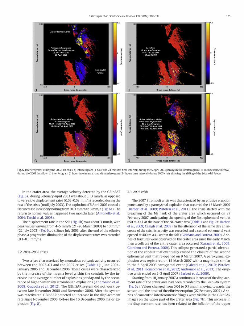
Fig. 6. Interferograms during the 2002–03 crisis. a) Interferogram (1 hour and 24 minutes time interval) during the 5 April 2003 paroxysm; b) interferogram (11 minutes time interval)during the 2003 lava flow; c) interferogram (1 hour time interval) and d) interferogram (24 hours time interval) during 2003 crisis showing the sliding of the Sciara del Fuoco.
325F. Di Traglia et al. / Earth-Science Reviews 139 (2014) 317–335
In the crater area, the average velocity detected by the GBInSAR(Fig. 5a) during February-April 2003 was about 0.13 mm/h, as opposedto very slow displacement rates (0.02–0.03 mm/h) recorded during therest of the crisis (until July 2003). The explosion of 5 April 2003 caused afast increase in velocity bolting from0.03mm/h to 3mm/h (Fig. 6a). Thereturn to normal values happened two months later (Antonello et al.,2004; Tarchi et al., 2008).
The displacement rate in the SdF (Fig. 5b) was about 3 mm/h, withpeak values varying from 4–5 mm/h (21–26 March 2003) to 10 mm/h(22 July 2003) (Fig. 6c, d). Since July 2003, after the end of the effusivephase, a progressive diminution of the displacement rateswas recorded(0.1–0.3 mm/h).
5.2. 2004–2006 crises
Two crises characterized by anomalous volcanic activity occurredbetween the 2002–03 and the 2007 crises (Table 1): June 2004–January 2005 and December 2006. These crises were characterizedby the increase of the magma level within the conduit, by the in-crease in the average number of explosions per day and by the occur-rence of higher-intensity strombolian explosions (Andronico et al.,2008; Coppola et al., 2012). The GBInSAR system did not work be-tween late November 2005 and November 2006. After the systemwas reactivated, GBInSAR detected an increase in the displacementrate since November 2006, before the 16 December 2006 major ex-plosion (Fig. 5).
5.3. 2007 crisis
The 2007 Stromboli crisis was characterized by an effusive eruptionpunctuated by a paroxysmal explosion that occurred the 15 March 2007(Barberi et al., 2009; Pistolesi et al., 2011). The crisis started with thebreaching of the NE flank of the crater area which occurred on 27February 2007, anticipating the opening of the first ephemeral vent at650 m a.s.l. at the base of the NE crater area (Table 1 and Fig. 7a; Barberiet al., 2009; Casagli et al., 2009). In the afternoon of the same day an in-crease of the seismic activity was recorded and a second ephemeral ventopened at 400 m a.s.l. within the SdF (Giordano and Porreca, 2009). A se-ries of fractures were observed on the crater area since the early March,then a collapse of the entire crater area occurred (Casagli et al., 2009;Giordano and Porreca, 2009). This collapse generated a partial obstruc-tion of the conduit that eventually caused the closure of the secondephemeral vent that re-opened on 9 March 2007. A paroxysmal ex-plosion was registered on 15 March 2007 with a magnitude similarto the 5 April 2003 paroxysmal event (Calvari et al., 2010; Pistolesiet al., 2011; Bonaccorso et al., 2012; Andronico et al., 2013). The erup-tive crisis ended on 2–3 April 2007 (Barberi et al., 2009).
Starting from 10 January 2007 a continuous increase of the displace-ment rate of the crater area had been recorded by the GBInSAR system(Fig. 5a). Values changed from 0.04 to 0.7 mm/h moving towards thesensor until the onset of the effusive eruption (27 February 2007). A se-ries of concentric interferometric fringes were visible in the GBInSARimages on the upper part of the crater area (Fig. 7b). This increase inthe displacement rate has been related to the inflation of the upper

Fig. 7. Interferograms during the 2007 crisis. a) interferogram (21 minutes time interval) during the 27 February 2007 vent opening; b) interferogram (12 minutes time interval) duringthe inflation after 27 February 2007 vent opening; c) interferogram (11 minutes time interval) and d) interferogram (24 hours time interval) during 2003 crisis showing the sliding of theSciara del Fuoco.
326 F. Di Traglia et al. / Earth-Science Reviews 139 (2014) 317–335
part of the volcanic edifice (Casagli et al., 2009). The base of the NE cra-ter area, near to the collapsed Pianoro area (Fig. 7c), showed a displace-ment rate in the range of 10–12 mm/h. Between 27 February and 12April 2007 the GBInSAR system was able to record, on the crater area,two cycles of displacements towards and backwards with respect tothe sensor. In detail, the GBInSAR recorded inflation before the openingof each effusive vent and a deflation afterwards (from −1.5 mm/h to+6 mm/h on 27 February 2007, and from −0.5 mm/h to +7.0 mm/hon 15 March 2007; Fig. 5a). During the 15 March 2007 paroxysmalexplosion, a rapid increase in the displacement rate was recorded inthe crater area (7.0 mm/h; Fig. 7a; Casagli et al., 2009).
Since 15 February 2007, on the upper part of the SdF the GBInSARrecorded a sudden increase in the displacement rate from 0.02 to0.25 mm/h, which was maintained until the eruptive crisis onset,on 27 February 2007, with displacement rate between 30 mm/h to0.2 mm/h (Fig. 5b; Fig. 7c and d). Between 8 and 9 March 2007, therecorded displacement rate along the SdF increased again, from1.5mm/h to 5 mm/h. From 11:17 and 11:28 UTC of 9March 2007, in-terferogram highlights a very high displacement rate (more than300 mm/h), exceeding the capability of the correct phaseunwrapping. This phenomenon has been recorded through thehours preceding the re-opening of the ephemeral vent at400 m a.s.l.. During the period 9–15 March 2007 the displacementrate in the SdF showed a constant value of about 0.5 mm/h (Fig. 5).No displacements were registered on the SdF during the 15 March2007 paroxysmal explosion (Fig. 5).
5.4. 2008–2013 crises
Six crises characterized by anomalous volcanic activity occurred be-tween 2008 and 2013 (Calvari et al., 2014): September 2008; December2008; March–May 2009; November 2009–January 2010; June–September 2011; December 2012–May 2013 (Table 1).
During the September 2008 crisis, characterized by the occurrence ofa major explosion (7 September 2008; Table 1; Calvari et al., 2011a)only a syn-explosive displacement of the crater area was recorded,while no precursory displacements were detected before the majorexplosion.
Throughout December 2008, characterized by the occurrence of twomajor explosions (6 and 17 December 2008; Table 1), in the crater areawere recorded only syn-eruptive displacements during the majorexplosions (Fig. 5a), whereas a strong increase in the displacementrate was detected in the SdF (up to 0.5 mm/h) in the period 12–16December 2008 (Fig. 5b).
Displacement rate in sector 3 increased progressively from0.05 mm/h during early March to 0.35 mm/h on 27 March, just twodays before the lava outflows from the summit crater area (Fig. 5).The displacements in sectors 2 and 3 (Fig. 5a) remained high (averageabout 0.11 mm/h) for the following two months with peaks on 3 April(0.27 mm/h) and 14 April 2009 (0.2 mm/h) and 3 May 2009(0.25 mm/h, during a major explosion) and 22 May 2009 (0.23 mm/h).The 3 May 2009 explosion produced high-displacement rate in sector2 at the time of the explosion (50.6 mm/h; Fig. 5a).

Fig. 8. Interferograms during the 2008–13 crises. a) interferogram (11 minutes time interval) during the 16 February 2012 major explosion; b) interferogram (12 hours time interval)showing inflation of the sector 2 before the 2012–13 crisis; c) interferogram (7 days time interval) showing deflation of the sector 2 before the 2012–13 crisis interferogram;d) interferogram (11 minutes time interval) showing the sliding of thematerials on the rim of the NE crater; e) interferogram (8 hours time interval) showing inflation of sector 3 beforethe 2012–13; f) interferogram (7 days time interval) showing the inflation of the Sciara del Fuoco during the 2011 crisis.
327F. Di Traglia et al. / Earth-Science Reviews 139 (2014) 317–335
Throughout the November 2009–January 2010 period an increase inthe displacement rate was observed starting from 2 November 2009(from 0.02 mm/h to 0.56 mm/h in sector 3) that ended with theexplosion of 8November 2009 (0.6mm/h in sector 2). Analogous trendshave been observed in the periods between 19 and 23 November 2009(0.25–0.3mm/h in sector 3), 20 and 28December 2009 (0.25–0.29mm/hin sector 3), 6 and 9 January 2010 (0.24–0.29 mm/h in sector 3) andfinally, 16 and 20 January 2010 (0.2–0.3 mm/h in sector 3). During the8November 2009 and 24November 2009major explosions, the GBInSARrevealed a series of concentric fringes on the upper part of sector 2 on the1-hour interferograms, showing a strong peak of displacement rate about12.1 mm/h and 45.5 mm/h, respectively.
Before the June-September 2011 crisis, an increase in the displace-ment rate of sector 3 was recorded during May 2011. In the period 8–19May2011, on 4-hours and 8-hours interferograms, the bottomof sec-tor 3 showedhigh coherence and a displacement rate up to 5.5mm/hwasrecorded. The GBInSAR detected high displacement rate on sector2 only during the 20 June 2011 (10.6 mm/h) and 5 July 2011 majorexplosions (6.5 mm/h), while displacement rate remained in thebelow 0.1 mm/h during all the crisis (Di Traglia et al., 2014b).
After the June-September 2011 crisis, isolated major explosionsoccurred on 16 February 2012, producing significant displacements inthe crater sectors (Fig. 8a). A significant increase in the displacementrate was observed in sector 2 on 12-hour, 24-hour and 7-day interfero-grams, since the end of November 2012 (Fig. 8b). In detail, a strongincrease in the values was observed from the end of November untilthe 22 December 2012 (from 0.01 to 0.12 mm/h); subsequently it
decreased until 12 January 2013. Between 14 and 21 January 2013 theGBInSAR system registered a movement away from the sensor, coevalwith a large overflow from the NE crater (Fig. 8c). Subsequently,between 1 and 6 February 2013 the GBInSAR registered displacementstoward the sensor that increased again (0.08 mm/h). A similar trendwas recorded between 27 February and 13 March 2013 (peak at0.18 mm/h).
During this period, some crater collapse events were observed,sometimes associated with the increase in the displacement rate in sec-tor 1 (Fig. 8d). Regarding sector 3, corresponding to the debris coneof the NE crater, a significant increase in displacement rate valueswas recorded on 24-hours interferograms since 18 December 2012(Fig. 5a). The displacement rate in sector 3 increased (1.7 mm/h) andremained at high levels (more than 1 mm/h) in all the period lateDecember 2012–early March 2013 (i.e. Fig. 8e), with some fluctuations(increase/decrease). Peaks in displacement rate have been recordedon 24 December 2012 (10.9 mm/h), 24 January 2013 (2 mm/h), 27January 2013 (1.8 mm/h), 7 February 2013 (8.6 mm/h), 22 February2013 (5.3 mm/h), 1 march 2013 (8.1 mm/h), 3 March 2013 (7.6 mm/h),4 March 2013 (8.1 mm/h) and 10 March 2013 (10.6 mm/h).
While the deformations in the crater area were well differentiatedon short time interval interferograms, the movements on the SdFwere slower and needed an appropriate time interval to be detected(monthly-annual interferograms; Intrieri et al., 2013; Nolesini et al.,2013). An increase in the displacement rate on sector 4 and 5 wasrecognized (28-day interferograms) starting on 8 November 2009(0.019 mm/h) and ending on 13 November 2009, with the maximum
328 F. Di Traglia et al. / Earth-Science Reviews 139 (2014) 317–335
displacement located in the upper zone of each sector. A similar dis-placement has been observed on the two SdF sectors between 19 and23 February 2010 (0.02 mm/h), in the period between the 10 January2010 and 12 March 2010 major explosions. Since 1 January until 21April 2011, the displacement rate had strong variations up to0.014 mm/h. After these periods, the displacement returned on verylow values (b0.01 mm/h) for a long period of time (22 April 2011–24September 2011). During this period, on 1–2 August 2011 a lava over-flow spilled from the NE crater reached sector 4 causing shallow land-slides (Nolesini et al., 2013). Increase in the displacement rate wasrecorded in the period September–October 2011 (Fig. 8f) with a maxi-mum value of 0.5 mm/day, then the displacement rate decreased againand returned to very low values (b0.01 mm/h). All through the entireDecember 2012–June 2013 period, the monitoring system recorded veryslow movements in both Sciara del Fuoco’s sectors (0.001–0.003 mm/h).
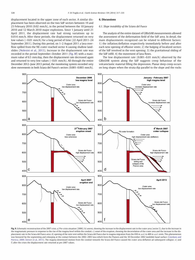
Fig. 9. Schematic reconstruction of the 2007 crisis. a) Pre-crisis situation (2006); b) unrest, showthemagmastatic pressure in response to the rise of the magma level within the conduit; c) onsplacement rate in the Sciara del Fuoco area; d) opening of the new vent within the Sciara del Fuwas favoured by the segmenting and enlarging at the contact between the 2002–2003 lava wPorreca, 2009; Intrieri et al., 2013). The magma downward motion from the conduit towarf) after the crises the displacement rate returned at pre-2007 values.
6. Discussions
6.1. Slope instability of the Sciara del Fuoco
The analysis of the entire dataset of GBInSARmeasurements allowedthe assessment of the deformation field of the SdF area. In detail, themain displacements recognized can be related to different factors:1) the inflation/deflation respectively immediately before and aftereach new opening of effusive vents; 2) the bulging of localized sectorsof the SdF involved in the vent opening; 3) the gravitational sliding ofthe SdF infill; 4) the movement of lava flows.
The low displacement rate (0.001–0.01 mm/h) observed by theGBInSAR system along the SdF suggests creep behaviour of thevolcaniclastic material filling the depression. Planar deep creep occurson long slopes when the strata dip parallel to the slope and the rocks
ing the increase in the displacement rate in the crater area (sector 2), due to the increase inet of the eruption, showing the decorrelation of the crater area and the increase in the dis-oco due to magmamigration from the 650m a.s.l. to 400m a.s.l. vents. This phenomenonhich form the Pianoro and the 30 December 2002 landslide basal surface (Giordano andds the Sciara del Fuoco caused the crater area deflation ad subsequent collapse; e) and

329F. Di Traglia et al. / Earth-Science Reviews 139 (2014) 317–335
have different rheological characteristics (Ter-Stepanian, 1966). One ofthe possible mechanisms could be the sliding of lava on volcaniclasticproducts at many planar discontinuities, which has been observed byBoldini et al. (2009). Such mechanism is consistent with the pattern ofthe displacement maps recorded by the GBInSAR, as described byIntrieri et al. (2013). The seawards motions of the SdF can also occurbased only on the force of gravity, without coeval magma intrusion(Tibaldi et al., 2009; Nolesini et al., 2013). After a period of creep move-ments, sheet intrusion can occur during a stage of increasing magmaoverpressure, relieving the extensional strain accumulated during theprevious slip (Tibaldi et al., 2009). Slopes subjected to creep are proneto failure because the slow motion may reduce strength at shear zones(Voight and Elsworth, 1997; Hurlimann et al., 2001).
GBInSAR data, together with field observations carried out after theonset of the 2007 crisis (Casagli et al., 2009), suggest that the observeddisplacements are coherent with a NE-elongated sub-volcanic intru-sions, localized on the upper part of the SdF (Casagli et al., 2009;Giordano and Porreca, 2009). The resulting bulging of the topographicsurface is elongated parallel to the dyke strike, as well as faulting andfracturing occur with the same parallel strike (Gudmundsson andLoetveit, 2005).
Intrusions at Stromboli, once fed along the collapse axis from theupper rim of the SdF depression (Linde et al., 2014), mainly propagatewithin the collapse as the result of the deflection of the stress trajecto-ries at the sides of the depression (Acocella and Tibaldi, 2005; Acocellaand Neri, 2009; Neri et al., 2008; Tibaldi et al., 2008; Intrieri et al.,2013). Increase in magma overpressure, related to the volumetric ex-pansion due to large gas flux from depth, promotes the lateral intrusionof sheets (Di Traglia et al., 2013; Nolesini et al., 2013). In the 2007 erup-tion, Vent 1 (650 m) was dyke-fed (NE–SW striking) and propagatedfurther downslope to 400m a.s.l. (Vent 2) and the variation in thedirec-tion of the dike-fed Vents 1 and 2 is supposed to be the result of thetopography-induced deflection along the scar of the December 2002landslide (Neri et al., 2008; Intrieri et al., 2013).
The NE-striking dyke also produces a lateralmagma force exerted onthe dyke walls in a SE–NW direction, as previously suggested by anumber of authors (Apuani et al., 2005a,b, 2007 and references therein).This lateral force can enhance the gravity instability of the SdF infill.These intrusions can stop at depth, promoting the movement of partof the SdF seawardswithout the occurrence of ephemeral vents or land-slides (Casagli et al., 2009; Nolesini et al., 2013).
6.2. Structural framework of the summit area
The GBInSAR data presented here allow the constraining of thestructural setting of the summit crater area of Stromboli volcano. Fromthe analysis of interferograms and cumulative displacement maps, asharp boundary between the two main sectors of the outer flank ofthe crater terrace (sector 2 and 3) is evident. During the 2007 and2012–13 crises, a strong increase in the displacement rate on sector 2has been recorded two months and one month before the onset of the2007 and the 2012–2013 crises, respectively. The increase in thedisplacement rate involved the entire sector 2, but in both cases themaximum displacement was located at the boundary between sector2 and 3. This boundary could represent planes of weakness related tothe collapse of the summit crater terrace.
During the 2007 crisis, the GBInSAR was able to record fluctuationsin the displacement rate towards and backwards with respect to thesensor, interpreted as inflation-deflation of the uppermost volcanic sys-tem (Fig. 9). The inflations occurred before the opening of the effusivevents (27 February 2007; 9 March 2007), while deflation occurred inbetween the two events and after the second vent opening (Casagliet al., 2009). These two periods of deflations correspond to the incre-mental collapse of the summit crater area of Stromboli (Barberi et al.,2009). The 2007 crater collapse was associated with sudden increasein the number of earthquakes occurred on 7–8 March 2007 (about 60
events/h defined “hybrids” because of a frequency content of 4–5 Hz;Martini et al., 2007). Calvari et al. (2010) report the first observationof a summit crater collapse on 4 March, possibly occurred even earlierbut hidden by clouds. A progressive fracturing was observed since 8March 2007 until 13 March 2007 (Barberi et al., 2009), forming acollapse structure of a volume of about 1.5×10⁶ m3 (Marsella et al.,2009), with a thickness of the collapsed block in the range 80–150 m(Fig. 9; Neri and Lanzafame, 2009), giving an aspect ratio of 1.8 and aT/D ~0.5 (thickness/width ratio; Ruch et al., 2012). During the 2007 cri-sis, the downthrownmotion of the northern portion of the SdF allowedtheobservation of the inner structure of thenorthern part of the summitarea (Casagli et al., 2009). This is affected by a series of slip planes dip-ping towards the NW (i.e. towards the sea) at angles of 60°–80° andfield observations indicate the presence of normal offsets (Casagliet al., 2009). As reported before, theGBInSAR recorded two cycles of dis-placements towards and backwardswith respect to the sensor. In detail,the GBInSAR recorded an increase in the displacement rate away fromthe sensor (deflation) since the onset of the crisis (27 February 2007)until the 7March 2007, when a large displacement rate toward the sen-sor have been registered in both the summit crater area and in the SdF(Casagli et al., 2009). The displacement vector inverted direction againafter the re-opening of the effusive Vent 2 (400 m a.s.l.). The 2007 col-lapse of the summit crater area at Stromboli is in agreementwith the ex-perimental data of Ruch et al. (2012). For incremental collapse structurewith T/D ratio b 2 and pre-existing collapse structure Ruch et al. (2012)suggested that the subsidence of the collapsing block is expected to becoupled with the rate of magma withdrawal, as observed at Stromboli(aspect ratio 0.13; Neri et al., 2008; Marsella et al., 2009). Moreover,even if the GBInSAR data revealed that the 2007 summit area startedto subside soon after the onset of the effusive eruption (27 February)and the fracturing the crater terrace were observed on the 4 March(and possibly occurred earlier; Calvari et al., 2010), the larger part ofthe collapse occurred in few days, as suggested by the occurrence ofthe “hybrids” seismic signals (Martini et al., 2007). This is in agreementwith the experimental data of Roche et al. (2001) for pit-craterswith as-pect ratio between 1 and 2. In these experiments, the initial sub surfacecollapse is followed by sudden roof collapse (Roche et al., 2001).
The presence of several slip zones that regulated the collapse of thesummit crater area in the recent years has been yet recognized byFinizola et al. (2003) by means of geophysical and geochemical surveys(temperature, self-potential, CO2 soil flux). The Pizzo slip zones are in-voked to explain the geometry of the summit collapses (large pit craterformations) at Stromboli, while our GBInSAR data evidenced that thesame structural features are also involved during the inflation-deflation fluctuations of the volcano.
The integration of GBInSAR, numericalmodelling and structuralfielddata, has been used to explain the ground deformation observed duringthe 2007 crisis. The pressurization of the shallow conduit system hasbeen invoked to explain the observed deformations (Casagli et al.,2009). Increase in displacement rate in sector 2 (Fig. 4c) has been relat-ed to the increase in the magmastatic pressure within the conduit, as aconsequence of the rise of the magma level (Fig. 9b), while the increasein the displacement rate in sector 3 (Fig. 4c) has been considered as theevidence of the pressurization and lateral expansion of the shallow con-duit system of Stromboli volcano (Di Traglia et al., 2013, 2014a,b). Insector 3, increases in the displacement rate have been observed manytimes before the onset of the 2009–2013 crises (Di Traglia et al.,2013). Before the onset of the 2011 and 2012–13 crises, displacementswere located in the lower part of sector 3 (600–650 m a.s.l.). Duringthe 2012–13 crisis (Table 1), the localization of the displacementsin sector 3 changed with time. Six days before (18 December 2012)the onset the maximum displacement rate was located near the top ofthe sector (700–750 m a.s.l.), while it lowered in elevation (650–700 m a.s.l.) during February-March 2013. Sector 3 corresponds to theopening area of the ephemeral vent of the 2002–03 and 2007 flankeruptions (Neri et al., 2008) and vent opening in sector 3 occurs when

330 F. Di Traglia et al. / Earth-Science Reviews 139 (2014) 317–335
themagma overpressure exceeds the rock stiffness (Casagli et al., 2009;Nolesini et al., 2013). The chronology of the onset of the 2012–13 crisis,in terms of inflation/NE-ward expansion of the summit area/deflation,resembles the sequence of events that occurred at the beginning ofthe 2007 crisis (inflation; eccentric effusion at the base of the NE crater;collapse of the summit area), suggesting a self-similar behaviour of theshallow-plumbing system at Stromboli volcano. During sheet propaga-tion in a volcanic edifice, the energy release rate (energy available todrive fracture propagation; Gudmundsson, 2012) could change, de-pending on the type of boundary conditions applied and the sheet ge-ometry. When the boundaries of a volcanic zone (in the Strombolicase it refers to the summit crater area) cannot move during an unrestperiod and sheet development, the only source of potential energy forthe sheet development is the strain energy stored in the volcano beforesheet propagation starts, mainly due to the stretching related to the ex-tensional forces (Gudmundsson, 2009, 2011, 2012). The strain energystored in the volcano is transformed into surface energy and largelydissipated during fracture propagation (Gudmundsson, 2012).Since no energy is added to the system during the fracturepropagation, the strain energy decreases and the sheet stops. If theboundaries of the volcanic edifice can move during the fracture de-velopment, there are two principal sources of potential energy forthe fracture development: the stored strain energy in the volcanicedifice and the work done by the external, generalized loading orforce. The constant-displacement boundary conditions result in sta-ble fracture propagation, i.e. as the fracture propagates the energy(stored strain energy) available to drive the fracture gradually de-creases. Thus, constant-displacement boundary conditions favourcomparatively small eruptions (for dykes), while constant-loadboundary conditions result in an unstable fracture propagation,therefore favouring comparatively large eruptions. Horizontallypropagating intrusions can only emplace if edifice load preventseruption through the central area and if magma is negatively buoy-ant at shallow depth (Pinel and Jaupart, 2004; Di Traglia et al.,2013). In a volcanic edifice, at small distances from the feeder con-duit axis, confining stresses act to prevent vertical propagation anda bulge develops at some distance from the focal area, which ac-counts for ephemeral vents in the SdF (Pinel and Jaupart, 2004; DiTraglia et al., 2013).
At Stromboli, the GBInSAR recorded a displacement rate in sector 2of the same order of magnitude for both the 2007 and the 2012–13crises. The peak in displacement rate during the 2007 eruption hasbeen reached only during the ephemeral vent opening, i.e. when themagma overpressure was high enough to laterally propagate the con-duit system forming a NE-SW striking dyke. During the (magmastatic)pressure built up of both eruptions, due to the rise of the magma levelin the conduit, the existence of an upper limit of the displacement rate(b1 mm/h for the 2007 flank eruption) allowed us to speculate that theinitial phases of Stromboli eruptions are characterized by a constantload (the flanks of the summit crater area can expand during pressurebuild-up), while, reaching the displacement rate of 0.7–0.8 mm/h, theboundary conditions change and the sheet propagation occurs at fixedboundary (constant displacement) condition. This implies that, if thereis nomagma overpressure (due to pressurization of the HP-filled conduitrelated here to the degassing of the LP magma; Di Traglia et al., 2013) orweakening of the country rocks, the fractures no longer propagate,preventing the development of a flank effusion. Magma pressure (ptot)acting on the dyke consists of themagma-static (pm) and an overpressure(po) components (Voight and Elsworth, 1997; Apuani and Corazzato,2009). The maximum magmastatic pressure component, responsible ofthe upper limit of the displacement rate in sector 2, can be easily evaluat-ed considering the variation of themagma levelwithin the Stromboli con-duit. The magmastatic pressure can be calculated as:
pm ¼ γm � z
Where ϒm and z are the average magma unit weight (25.5 kN/m3;Barberi et al., 1993) and the height of the dyke, respectively. Calculatingthe pressure variation at different heights, considering the change in theelevation of the maximum displacement in sector 3 (max. 100 m), thechange in the magma-static pressure related to the rise of the magmalevel of about 2 MPa can be evaluated.
Themagma overpressure responsible for the lateral propagation canbe evaluated considering that magma flow in a sheet intrusion can bedriven by the excessmagmapressure at the source, themagmabuoyan-cy and the gradients of the ‘tectonic’ stress normal to the sheet plane(Rubin, 1995). Di Traglia et al. (2013) and Nolesini et al. (2013) pro-posed a range of magma overpressures characterizing both the 2009–2013 crises and the 2007 flank eruption, considering the ‘tectonic’ stressnormal to the sheet plane to be constant (no strong earthquake in theconsidering period). Local stress configuration, e.g. due to changes inmorphology, could control the direction and geometry of emplacementof the intrusion, as extensively demonstrated at Stromboli around theSdF after sector collapses (Tibaldi, 2001, 2003; Tibaldi et al., 2009).However, during the investigated period, the morphological changesof sector 3 were not likely to redefine the orientation of the local stress.Magma buoyancy can be neglected because it generally affects thevertical propagation of intrusion (magmastatic pressure), rather thana lateral propagation (Rubin, 1995). Considering these assumptionsand limitations and using the deformation rate as a proxy for theorder of magnitude of the sheet propagation rate (U), the magma over-pressure (po) needed to generate the registered deformation rates canbe evaluated by:
U ¼ lp3o=3ηΜ2
whereM is the host rock elastic stiffness, η is themagma viscosity and lis the intrusion length (Rubin, 1995). Regarding the host rock elasticstiffness, we chose the range of 10–20 GPa proposed by Apuani et al.(2005a,b) and Rotonda et al. (2010) and not considering possible localvariations (Thomas et al., 2004; Gudmundsson, 2011). This assumptionis based on the observations made on the lithic ejected during the par-oxysmal explosions, considered as samples of the host rocks of the shal-low conduit system (Pistolesi et al., 2008), considered as samples of thecountry rock bounding the shallow conduit system. Ballistic blocks arequite different: the SW crater mainly produces hydrothermally alteredfragments, material altered from fumarolic activity and vesicular alteredlavas (Del Moro et al., 2013), likely representing the brittle failure of theconduit wall rocks due to the ascent of an overpressurized gas-slug(Rosi et al., 2006). In the other hand, the NE crater produces fresh,holocrystalline subvolcanic blocks, representing the slowly cooledequivalents of the HP magmas feeding the normal Strombolian explo-sions (Pistolesi et al., 2008; Renzulli et al., 2009).
TheHPmagmaviscosity is in the order of 104–105 Pa · s (Vona et al.,2011) and the intrusion length is in the interval of 100–300 m, consid-ered as the distance between the in-depth projection of the NE craterconduit and the tip of the intrusion, allowing for both the error in theexact location of the conduit and in the intrusion depth (Chouet et al.,2003). Overpressures were obtained on the order of 10−2 MPa for alow displacement rate in sector 3 (b0.1 mm/h), 10−1 MPa for displace-ment rates typical for the crises dominated by overflows and major ex-plosions (0.1–10 mm/h) and 100–101 MPa for the high displacementrate (N10 mm/h) as during the2007 and 2012–13 crisis. In this scenario,the observed long-term (monthly) fluctuations of ground displacement(the high-displacement rate that characterized each crisis) can berelated to cyclic pressurisation phases of the magma column withinthe feeding system by gas-rich magma (Coppola et al., 2012). At thesame time, short-term fluctuation in the displacement rate, as revealedby Di Traglia et al. (2014a,b), could reflect short-term pressurizationevents on a time scale of minutes or hours, that produces fluctuationsin degassing and explosive activity (Coppola et al., 2012).
331F. Di Traglia et al. / Earth-Science Reviews 139 (2014) 317–335
An alternative explanation of the difference between the 2007 flankeruption and the post–2007 crises have been proposed by Coppola et al.(2012, 2014) and Calvari et al. (2014). These authors observed a differ-ent behaviour in the eruptive activity between during the 2005–2006(pre-2007 crises) and 2008–2012 (post-2007 crises) periods. They sug-gested that this is an indication that the uprising of magma, and its stor-age at shallow levels, was markedly perturbed by the February 2007eruption (Coppola et al., 2014). Calvari et al. (2014) support this hy-pothesis using SO2 and CO2 recorded from the plume, coupled withthe temperature recorded at low-elevation fumaroles. They observedthat the increase in the number of lava overflows and major explosionsis not related to anomalously high supplies of gas-rich magma risingalong the conduit. Calvari et al. (2014) thus suggest that the observedgeochemical trends are due to the increased capacity of the uppermostconduit to accommodate a larger amount of magma in an articulatedfingering system developed beneath the craters, formed after the 2007collapse of the crater area.
These two scenarios are not opposed. In fact, the 2007 collapse of thecrater area likely affected the very shallow plumbing system at Strom-boli, increasing the magma volume that can be accumulated beneaththe crater terrace and then increasing the limit of the displacementrate for the constant load/constant displacement transition. This pro-cesses will have in turn decreased the occurrence of large lava flows,compared with overflows (Coppola et al., 2012, 2014; Calvari et al.,2014), decreasing the ability to decompress the deeper storage system,triggering the ascent of the gas-rich magma responsible of the paroxys-mal explosions (Aiuppa et al., 2009, 2010; Calvari et al., 2011b). As stat-ed by Calvari et al. (2014), this process will probably eventually endwith the restoration of the previous central conduit path, mainly bythe thermal erosion that normally acts beneath the Stromboli crater ter-race (Del Moro et al., 2013).
Meanwhile, pre- and post-2007 plume CO2/SO2 ratio was similar forboth inter-crises and crises periods (Aiuppa et al., 2009, 2010, 2011; LaSpina et al., 2013) testifying that the same processes of shallowmagmadegassing occurred, supporting the short-term fluctuation in the dis-placement rate during each eruptive crisis recorded by the GB-InSARsystem (Di Traglia et al., 2014a,b).
6.3. Changing in eruption intensity at Stromboli volcano
On a long-time scale, the GBInSAR recorded a fluctuating behaviourof the summit crater area (mainly sector 2), with periods of increases inthe displacement rate that anticipated and accompanied the volcaniccrisis and a reduction in the displacement rate following the crisis.During a single period of higher volcanic activity, fluctuations havebeen also recorded in a shorter time scale (days to weeks). Similar re-sults have been obtained from the analysis of other geophysical andgeochemical parameters. In particular, Coppola et al. (2012, 2014), com-paring the number of explosions (Very Long Periods seismic events) perdaywith the radiative power emitted by Stromboli craters and detectedby MODIS (Moderate Resolution Imaging Spectroradiometer) satelliteobservations, suggested that over the years 2000–2011 several fluctua-tions of rise and fall of the magma column (revealed by intermediate tohigh radiative power) have occurred. Only two rises of the magma col-umn culminated in effusive crisis (2002–03 and 2007), while the otherperiods did not evolve with lava effusion but only into episodes ofsustained spattering or fountaining and summit overflows (lava lakebehaviour; Coppola et al., 2012).
The geochemical monitoring network recognized similar results.Major explosions activity clusters in periods preceded by brief phasesof increasing CO2/SO2 weight ratio (up to N 40) and CO2 flux(N1300 t · d−1) with respect to the time averaged values of 3.7 and500 t · d−1 typical for standard Stromboli’s activity. On the otherhand, paroxysmal explosions and flank effusive eruptions occurred athigher CO2/SO2 ratio (up to 21; Aiuppa et al., 2009). It is worth noticingthat high CO2/SO2 ratios are strongly related to the deeper source, while
lower CO2/SO2 ratios reflect a stronger contribution from magmadegassing within the shallow conduit system (La Spina et al., 2013).
Fluctuations in the displacement rate are related to variations inflowrate through the shallow conduit system and thus to the rise speed ofthe magma beneath the vent (Parfitt, 2004). Variation in magma flowrate can be explained by magma convection within the plumbing sys-tem of Stromboli (Burton et al., 2007a,b; Witham, 2011) and the in-creasing gas content of the magma induces a faster rate of magmaconvection (Aiuppa et al., 2010). High magma column occurs whenthe rate of magma supplied at depth and degassing within the feedingsystem is balanced by an equal amount of lava discharged at the ventsor degassed magma is cycled back within the conduit (typically0.3 m3 · s−1 at Stromboli; Allard et al., 1994; Coppola et al., 2012). Ahigher supply rate is necessary to shift the eruptive intensity to a higherlevel, promoting the occurrence of eccentric effusive and/or paroxysmalactivity (Allard et al., 1994; Coppola et al., 2012). According to Lautzeand Houghton (2005, 2007), magmas with different vesicularity mayreside in the upper part of Stromboli's conduit system and the relativeabundance are due to on-going vesiculation andmixing/mingling of dif-ferent magmas. Variations in magma density have been mainly relatedto the density-driven overturning due to the gas transfer from thedeeper level to the HP magma residing in the shallow (b1 km) plumb-ing system of Stromboli volcano (Lautze and Houghton, 2005, 2007;Burton et al., 2007a,b; Aiuppa et al., 2009, 2010; Witham, 2011). Infact, CO2-rich gas bubbles are persistently supplied to the shallowplumbing system by degassing (and gas-melt separation) in the LPmagma storage zone. If the rate of supply of CO2-rich gas bubbles tothe shallow plumbing system is low, the close-to-surface gas–melt sep-aration from the shallow-convecting magma likely sustains the surfacegas emissions (Aiuppa et al., 2009). Moreover, density changes canbe also explained by the rise of the high-vesicular LP magma from 7–10 km deep (D’Oriano et al., 2011; Carbone et al., 2012). In this context,the rise and fall of the displacement rate in sector 2 can be related to themagma overturning within the conduit, with the increases in displace-ment rate during the upwelling of less dense magma. The displacementrate in sector 2 decreases as the degassedmagma column is pushed outfrom the conduit due to the rising of volatile-rich magma. Instead, thedecrease in the displacement rate without coeval lava outpouring(lava flows or overflows) could be related to the sink of the degassedmagma due to density contrast between the volatile poor and thevolatile-rich magmas.
6.4. The GBInSAR monitoring system: a tool for mitigating the risk connectedwith intense eruptive activity and flank dynamics at Stromboli volcano
As reported before, flank dynamics at Stromboli volcano is continu-ous, characterized by the near constant seawardmovement of the Sciaradel Fuoco flank. Tibaldi et al. (2009) suggest that the contrast of the rhe-ological properties between the consolidated pre-collapse rocks and thesuccessive looser infill of the collapse depression, together with the ex-istence of other discontinuities (buried collapse scarps and related frac-tures), are predisposing factors for gravitational instability in the Sciaradel Fuoco. Deformation occurs through creep and space is created alongthe lateral margins of the unstable sector through transtensional slip ofthe unstable sector. During this stage, risingmagma can escape from thecentral feeding zone creating sheets along the lateral margins of theunstable sector (Tibaldi et al., 2009). This implies that, after a period ofcreep movements, sheet emplacement can occur during a stage ofmagma upwelling under increased magma pressure (Tibaldi et al.,2009).
Thus, while flank dynamics of Stromboli volcano is a steady stateprocess, flank unrest is defined as any acceleration of the Sciara delFuoco and may be related to hazardous conditions as flank eruptions,surface fracturing and tsunamigenic landslides. Flank unrests atStromboli produce distinct structural, geophysical and volcanologicalevidences (Barberi et al., 2009). Movements of the Sciara del Fuoco

Fig. 10. Representative diagram for Stromboli unrest as operation tool for the mitigation of the Sciara del Fuoco dynamics and the increase in explosive activity. Different threshold arebased on the back-analysis of the 2003–2013 GBInSAR time series.
332 F. Di Traglia et al. / Earth-Science Reviews 139 (2014) 317–335
produced variations of the patterns of the surface displacements(Antonello et al., 2004; La Rocca et al., 2004; Bonforte et al., 2008;Casagli et al., 2009;Marchetti et al., 2009),while are generally anticipat-ed by changes in the eruptive activity, increases in the displacement ratein the summit area and variations in the geochemical parameters. As anexample, the increase in displacement rate in sector 2 and in the CO2/SO2 ratios anticipated the onset of the 2007 crisis by two weeks. Giventhese strong relationships between changes in the eruptive behaviour(and the associated geophysical and geochemical parameters) withthe flank eruptions in the Sciara del Fuoco, we define a scenario forthe flank unrest at Stromboli (Fig. 10). Using the displacement rate insector 2 and 3 as a proxy for the variation in the magmastatic pressurein conduit and for magma overpressure, respectively, thresholds forthe crises characterized by the occurrence of overflows (eventually as-sociated with major explosions) and flank effusions (eventually associ-ated with paroxysmal explosions) could be identified. Early increases indisplacement rate in sector 3, testifying the variations in the pressurecondition within the conduit due to CO2 released from depth (DiTraglia et al., 2013), generally anticipate the onset of an anomalousphase. Increases in the displacement rate in sector 2, testifying the in-crease in the magmastatic pressure due to the rise of the magma levelwithin the Stromboli conduit with constant load boundary conditions,anticipated the more intense phases of volcanic activity. During a singlecrisis, newly increases in the displacement rate in sector 3, duringphases of lateral conduit propagation at fixed boundary (constant dis-placement) condition, may anticipate the onset of effusive activity.Small conduit overpressure will produce overflows (sometimes associ-ated with crater-rim collapses), while large magma overpressure willlaterally expand the conduit forming a NE-SW striking dyke, feedingeruptive vents at the base of the summit crater area. Otherwise, theonset of flank unrest could be evaluated by monitoring the displace-ment rate in the SdF. Accelerations in this sector are related to sheet in-trusions, while the possibility of vent opening, associated with smallsliding, or catastrophic flank failure are related to high overpressurizedsheets, able to produce high displacement rate in the SdF. Unfortunate-ly, the GBInSAR system is able to monitor only the N portion of theSciara del Fuoco. Intrusions in the southern sector of the SdF wouldnot be anticipated without the placement of another GBInSAR systemon the S slope.
7. Conclusions
The GBInSAR system has been used to monitor the slope instabilityin the northern sector of the SdF and also to detect the inflation and
deflation of the N sector of the crater area, allowing us to define the un-stable area within the SdF and also to outline the structural frameworkof the summit area.
This work is the attempt to formalize the knowledge of the GBInSARmonitoring group gained from the last decade of monitoring activityand it is based on the conceptual model for flank dynamics and unrestsat Mt. Etna proposed by Acocella and Puglisi (2013). This scenario iscentred on the assumption that any potential event occurring in thefuture shows precursory displacement rates similar to those witnessedfor the same event in the last 10 years. The main limitations are relatedto relatively short monitoring time period (10 years) on which our sce-narios are based and hence the temporal extent for the applicability ofthis scenario (years to few decades). As an example, data on the prepa-ratory phase of large (Sciara del Fuoco-forming collapse; Tibaldi, 2001)tomoderate (30 December 2002-like event; Tommasi et al., 2005) slopefailure, as well as the preparatory phase of a large paroxysm period(1930-like event; Bertagnini et al., 2011), are still lacking. Moreover,the flank unrest scenario proposed here relies only on the GBInSAR dis-placement data, based on the observations available for the last 10 yearsat Stromboli, while a more complete scenario needs an integrated ap-proach merging volcanological, geochemical and the other geophysicalparameters (seismic, GPS, tilt, accelerometers, etc). Furthermore, thebiggest limitation to this work is the spatial coverage of the GBInSARdata. A larger area of the SdF and of the summit crater area (using aGBInSAR system in the southern edge of the Sciara del Fuoco) is neces-sary to create a complete displacement model for Stromboli volcano.
Acknowledgments
Thiswork has been sponsored in part by theNational Civil ProtectionDepartment (DPC) within the framework of the SAR.net, SAR.net2and InGrID projects and through the Istituto Nazionale di Geofisica eVulcanologia and DPC Stromboli emergency Project V2. The DPC is ac-knowledged for supporting the project and permitting this publication.The authors are grateful to Carlo Rivolta and Ivan Binda Rossetti (Ellegis.r.l. – Lisalab) for the technical support during the eruptive crises. Theauthors are grateful to A. Tibaldi (UniMiB) for his review and to G.R.Foulger for the editorial management. Sonia Calvari (INGV-OE) isgreatly acknowledged for her revisions, discussions and comments.FeDiT is supported by a post-doc fellowship founded by the RegioneToscana (UNIPI-FSE) under the project “Space-born and ground-basedSAR techniques for the evaluation of natural hazard” (RadSafe – UNIPI-4) in the framework of the research agreement between DST-UNIPI,DST-UNIFI and Ellegi s.r.l. Lisalab.

333F. Di Traglia et al. / Earth-Science Reviews 139 (2014) 317–335
References
Acocella, V., Tibaldi, A., 2005. Dike propagation driven by volcano collapse: a generalmodel tested at Stromboli, Italy. Geophys. Res. Lett. 32 (8).
Acocella, V., Neri, M., 2009. Dike propagation in volcanic edifices: overview and possibledevelopments. Tectonophysics 471 (1), 67–77.
Acocella, V., Puglisi, G., 2013. How to cope with volcano flank dynamics? A conceptualmodel behind possible scenarios for Mt. Etna. J. Volcanol. Geotherm. Res. 251,137–148.
Aiuppa, A., Federico, C., Giudice, G., Giuffrida, G., Guida, R., Gurrieri, S., Liuzzo, M., Moretti,R., Papale, P., 2009. The 2007 eruption of Stromboli volcano: insights from real-timemeasurements of the volcanic gas plume CO2/SO2 ratio. J. Volcanol. Geotherm. Res.182, 221–230.
Aiuppa, A., Burton, M., Caltabiano, T., Giudice, G., Guerrieri, S., Liuzzo, M., Mure, F., Salerno,G., 2010. Unusually large magmatic CO2 gas emissions prior to a basaltic paroxysm.Geophys. Res. Lett. 37, L17303.
Aiuppa, A., Burton, M., Allard, P., Caltabiano, T., Giudice, G., Gurrieri, S., Liuzzo, M., Salerno,G., 2011. First observational evidence for the CO2-driven origin of Stromboli's majorexplosions. Solid Earth 2, 135–142.
Allard, P.A., 2010. CO2-rich gas trigger of explosive paroxysms at Stromboli volcano, Italy.J. Volcanol. Geotherm. Res. 189, 363–374.
Allard, P., Carbonelle, J., Metrich, N., Loyer, H., Zettwoog, P., 1994. Sulfur output andmagma degassing budget of Stromboli volcano. Nature 368 (6469), 326–330.
Andronico, D., Corsaro, R.A., Cristaldi, A., Polacci, M., 2008. Characterizing high energyexplosive eruptions at Stromboli volcano using multidisciplinary data: An examplefrom the 9 January 2005 explosion. J. Volcanol. Geotherm. Res. 176, 541–550.
Andronico, D., Taddeucci, J., Cristaldi, A., Miraglia, L., Scarlato, P., Gaeta, M., 2013. The 15March 2007 paroxysm of Stromboli: video-image analysis, and textural and compo-sitional features of the erupted deposit. Bull. Volcanol. 75, 733.
Antonello, G., Casagli, N., Farina, P., Leva, D., Nico, G., Sieber, A.J., Tarchi, D., 2004. Ground-based SAR interferometry for monitoring mass movements. Landslides 1, 21–28.
Apuani, T., Corazzato, C., 2009. Numerical model of the Stromboli volcano (Italy)including the effect of magma pressure in the dyke system. Rock Mech. Rock. Eng.42, 53–72.
Apuani, T., Corazzato, C., Cancelli, A., Tibaldi, A., 2005a. Physical andmechanical propertiesof rock masses at Stromboli: a dataset for flank instability evaluation. Bull. Eng. Geol.Environ. 64, 419–432.
Apuani, T., Corazzato, C., Cancelli, A., Tibaldi, A., 2005b. Stability of a collapsing volcano(Stromboli–Italy): limit equilibrium analysis and numerical modelling. In:Gudmundsson, A., Acocella, V. (Eds.), The tectonics and physics of volcanoes. Specialissue. J. Volcanol. Geotherm. Res. 144, pp. 191–210.
Apuani, T., Merri, A., Masetti, M., 2007. In InternationalWorkshop on Volcanic Rocks, 11thISRM Congress. Effects of volcanic seismic events on the Stromboli stability by finitedifference numerical modeling. Taylor & Francis/Balkema.
Arrighi, S., Rosi, M., Tanguy, J.-C., Courtillot, V., 2004. Recent eruptive history of Stromboli(Aeolian Islands, Italy) determined from high accuracy archeomagnetic dating.Geophys. Res. Lett. 31, L19603.
Baldi, P., Coltelli, M., Fabris, M., Marsella, M., Tommasi, P., 2008. High precision photo-grammetry for monitoring the evolution of the NW flank of Stromboli volcano duringand after the 2002–2003 eruption. Bull. Volcanol. 70 (6), 703–715.
Barberi, F., Rosi, M., Sodi, A., 1993. Volcanic hazard assessment at Stromboli based onreview of historical data. Acta Vulcanol. 3, 173–187.
Barberi, F., Civetta, L., Rosi, M., Scandone, R., 2009. Chronology of the 2007 eruption ofStromboli and the activity of the Scientific Synthesis Group. J. Volcanol. Geotherm.Res. 182, 123–130.
Bertagnini, A., Landi, P., 1996. The Secche di Lazzaro pyroclastics of Stromboli volcano: aphreatomagmatic eruption related to the Sciara del Fuoco sector collapse. Bull.Volcanol. 58, 239–245.
Bertagnini, A., Di Roberto, A., Pompilio, M., 2011. Paroxysmal activity at Stromboli: lessonsfrom the past. Bull. Volcanol. 73, 1229–1243.
Blackburn, E.A., Wilson, L., Sparks, R.S.J., 1976. Mechanisms and dynamics of Strombolianactivity. J. Geol. Soc. Lond. 132, 429–440.
Boldini, D., Wang, F., Sassa, K., Tommasi, P., 2009. Application of large-scale ring sheartests to the analysis of tsunamigenic landslides at the Stromboli volcano, Italy.Landslides 6, 231–240.
Bonaccorso, A., 1998. Evidence of a dyke-sheet intrusion at Stromboli volcano inferredthrough continuous tilt. Geophys. Res. Lett. 25 (22), 4225–4228.
Bonaccorso, A., Davis, P.M., 1999. Models of ground deformation from vertical volcanicconduits with application to eruptions of Mount St. Helens and Mount Etna. J.Geophys. Res. Solid Earth (1978–2012) 104 (B5), 10531–10542.
Bonaccorso, A., Calvari, S., Garfì, G., Lodato, L., Patanè, D., 2003. Dynamics of the December2002 flank failure and tsunami at Stromboli volcano inferred by volcanological andgeophysical observations. Geophys. Res. Lett. 30 (18).
Bonaccorso, A., Gambino, S., Guglielmino, F., Mattia, M., Puglisi, G., Boschi, E., 2008.Stromboli 2007 eruption: Deflation modeling to infer shallow-intermediate plumb-ing system. Geophys. Res. Lett. 35, L06311.
Bonaccorso, A., Bonforte, A., Gambino, S., Mattia, M., Guglielmino, F., Puglisi, G., Boschi, E.,2009. Insight on recent Stromboli eruption inferred from terrestrial and satelliteground deformation measurements. J. Volcanol. Geotherm. Res. 182, 172–181.
Bonaccorso, A., Calvari, S., Linde, A., Sacks, S., Boschi, E., 2012. Dynamics of the shallowplumbing system investigated from borehole strainmeters and cameras during the15 March, 2007 Vulcanian paroxysm at Stromboli volcano. Earth Planet. Sci. Lett.357–358, 249–256.
Bonforte, A., Aloisi, M., Antonello, G., Casagli, N., Fortuny-Guash, J., Guerri, L., Nunnari, G.,Puglisi, G., Spata, A., Tarchi, D., 2008. Movements of the Sciara del Fuoco. In: Calvari,S., Inguaggiato, S., Puglisi, G., Ripepe, M., Rosi, M. (Eds.), The Stromboli volcano: an
integrated study of the 2002–2003 eruption. American Geophysical Union Mono-graph Series 182, pp. 183–199.
Burton, M.R., Allard, P., Murè, F., La Spina, A., 2007a. Magmatic gas composition revealsthe source depth of slug-driven Strombolian explosive activity. Science 317, 227–230.
Burton, M.R., Mader, H.M., Polacci, M., 2007b. The role of gas percolation in quiescentdegassing of persistently active basaltic volcanoes. Earth Planet. Sci. Lett. 264, 46–60.
Burton, M.R., Caltabiano, T., Murè, F., Salerno, G., Randazzo, D., 2009. SOb subN 2 flux fromStromboli during the 2007 eruption: Results from the FLAME network and traversemeasurements. J. Volcanol. Geotherm. Res. 182 (3), 214–220.
Calvari, S., Spampinato, L., Lodato, L., Harris, A.J.L., Patrick, M.R., Dehn, J., Burton, M.R.,Andronico, D., 2005. Chronology and complex volcanic processes during the2002–2003 flank eruption at Stromboli volcano (Italy) reconstructed from directobservations and surveys with a handheld thermal camera. J. Geophys. Res. SolidEarth 110 (B2).
Calvari, S., Lodato, L., Steffke, A., Cristaldi, A., Harris, A.J.L., Spampinato, L., Boschi, E., 2010.The 2007 Stromboli eruption: Event chronology and effusion rates using thermalinfrared data. J. Geophys. Res. B04201 http://dx.doi.org/10.1029/2009JB006478.
Calvari, S., Büttner, R., Cristaldi, A., Dellino, P., Giudicepietro, F., Orazi, M., Peluso, R.,Spampinato, L., Zimanowski, B., Boschi, E., 2011a. The 7 September 2008 Vulcanianexplosion at Stromboli volcano: Multiparametric characterization of the event andquantification of the ejecta. J. Geophys. Res. 117 (B5), B05201.
Calvari, S., Spampinato, L., Bonaccorso, A., Oppenheimer, C., Rivalta, E., Boschi, E., 2011b.Lava effusion – A slow fuse for paroxysms at Stromboli volcano? Earth Planet. Sci.Lett. 301, 317–323.
Calvari, S., Branca, S., Corsaro, R.A., De Beni, E., Miraglia, L., Norini, G.,Wijbrans, J., Boschi, E.,2011c. Reconstruction of the eruptive activity on the NE sector of Stromboli volcano:timing of flank eruptions since 15 ka. Bull. Volcanol. 73, 101–112.
Calvari, S., Büttner, R., Cristaldi, A., Dellino, P., Giudicepietro, F., Orazi, M., Peluso, R.,Spampinato, L., Zimanowski, B., Boschi, E., 2012. The 7 September 2008 Vulcanian ex-plosion at Stromboli volcano: Multiparametric characterization of the event andquantification of the ejecta. J. Geophys. Res. 117, B05201. http://dx.doi.org/10.1029/2011JB009048 B05201.
Calvari, S., Bonaccorso, A., Madonia, P., Neri, M., Liuzzo, M., Salerno, G.G., Behncke, B.,Caltabiano, T., Cristaldi, A., Giuffrida, G., La Spina, A., Marotta, E., Ricci, T.,Spampinato, L., 2014. Major eruptive style changes induced by structural modifica-tions of a shallow conduit system: the 2007–2012 Stromboli case. Bull. Volcanol.76, 841.
Carbone, D., Zuccarello, L., Montalto, P., Rymer, H., 2012. New geophysical insight into thedynamics of Stromboli volcano (Italy). Gondwana Res. 22, 290–299.
Casagli, N., Tibaldi, A., Merri, A., Del Ventisette, C., Apuani, T., Guerri, L., Fortuny-Guasch, J.,Tarchi, D., 2009. Deformation of Stromboli Volcano (Italy) during the 2007 crisis byradar interferometry, numerical modeling and field structural data. J. Volcanol.Geotherm. Res. 182, 182–200.
Casagli, N., Catani, F., Del Ventisette, C., Luzi, G., 2010. Monitoring, prediction and earlywarning using ground-based radar interferometry. Landslides 7, 291–301.
Chaussard, E., Amelung, F., Aoki, Y., 2013. Characterization of open and closed volcanicsystems in Indonesia and Mexico using InSAR time series. J. Geophys. Res. SolidEarth 118 (8), 3957–3969.
Chiocci, F.L., Romagnoli, C., Tommasi, P., Bosman, A., 2008. The Stromboli 2002tsunamigenic submarine slide: characteristics and possible failure mechanisms. J.Geophys. Res. 113, B10102.
Chouet, B., Dawson, P., Ohminato, T., Martini, M., Saccorotti, G., Giudicepietro, F., Scarpa, R.,2003. Source mechanisms of explosions at Stromboli Volcano, Italy, determined frommoment-tensor inversions of very-long-period data. J. Geophys. Res. Solid Earth(1978–2012) 108 (B1), ESE-7.
Coppola, D., Piscopo, D., Laiolo, M., Cigolini, C., Delle Donne, D., Ripepe, M., 2012. Radiativeheat power at Stromboli volcano during 2000–2011: Twelve years ofMODIS observa-tions. J. Volcanol. Geotherm. Res. 215–216, 48–60.
Coppola, D., Laiolo, M., Delle Donne, D., Ripepe, M., Cigolini, C., 2014. Hot-spot detectionand characterization of strombolian activity from MODIS infrared data. Int. J. RemoteSens. 35 (9), 3403–3426.
Del Bello, E., Llewellin, E.W., Taddeucci, J., Scarlato, P., Lane, S.J., 2012. An analytical modelfor gas overpressure in slug-driven explosions: insights into Strombolian volcaniceruptions. J. Geophys. Res. 117, B02206.
Del Moro, S., Renzulli, A., Landi, P., La Felice, S., Rosi, M., 2013. Unusual lapilli tuff ejectaerupted at Stromboli during the 15 March 2007 explosion shed light on the natureand thermal state of rocks forming the crater system of the volcano. J. Volcanol.Geotherm. Res. 254, 37–52.
Di Roberto, A., Bertagnini, A., Pompilio, M., Gamberi, F., Marani, M.P., Rosi, M., 2008. Newlydiscovered submarine flank eruption at Stromboli volcano (Aeolian Islands, Italy).Geophys. Res. Lett. 35, 16.
Di Roberto, A., Rosi, M., Bertagnini, A., Marani, M.P., Gamberi, F., 2010. Distal turbiditesand tsunamigenic landslides of Stromboli volcano (Aeolian Islands, Italy). Submarinemass movements and their consequences. Adv. Nat. Technol. Hazards Res. 28,719–731.
Di Roberto, A., Bertagnini, A., Pompilio, M., Bisson, M., 2014. Pyroclastic density currents atStromboli volcano (Aeolian Islands, Italy): a case study of the 1930 eruption. Bull.Volcanol. 76 (6), 1–14.
Di Traglia, F., Del Ventisette, C., Mugnai, F., Intrieri, E., Rosi, M., Moretti, S., Casagli, N., 2013.Ground Based InSAR reveals conduit pressurization pulses at Stromboli volcano.Terra Nova 25, 192–198.
Di Traglia, F., Intrieri, E., Nolesini, T., Bardi, F., Del Ventisette, C., Ferrigno, F., Frangioni, S.,Frodella, W., Giglio, G., Lotti, A., Tacconi Stefanelli, C., Tanteri, L., Leva, D., Casagli, N.,2014a. The ground-based InSAR monitoring system at Stromboli volcano: linkingchanges in displacement rate and intensity of persistent volcanic activity. Bull.Volcanol. 76, 1–18.
334 F. Di Traglia et al. / Earth-Science Reviews 139 (2014) 317–335
Di Traglia, F., Cauchie, L., Casagli, N., Saccorotti, G., 2014b. Decrypting geophysical signalsat Stromboli Volcano (Italy): integration of seismic and Ground-Based InSARdisplacement data. Geophys. Res. Lett. http://dx.doi.org/10.1002/2014GL059824.
D'Oriano, C., Bertagnini, A., Pompilio, M., 2011. Ash erupted during normal activity atStromboli (Aeolian Islands, Italy) raises questions on how the feeding systemworks. Bull. Volcanol. 73, 471–477.
Falsaperla, S., Maiolino, V., Spampinato, S., Jaquet, O., Neri, M., 2008. Sliding episodes dur-ing the 2002–2003 Stromboli lava effusion: insights from seismic, volcanic, and sta-tistical data analysis. Geochem. Geophys. Geosyst. 9 (4).
Finizola, A., Sortino, F., Lénat, J.F., Valenza, M., 2002. Fluid circulation at Stromboli Volcano(Aeolian Islands, Italy) from self-potential and CO2 surveys. J. Volcanol. Geotherm.Res. 116, 1–18.
Finizola, A., Sortino, F., Lénat, J.F., Aubert, M., Ripepe, M., Valenza, M., 2003. The summithydrothermal system of Stromboli. New insights from self-potential, temperature,CO2 and fumarolic fluid measurements, with structural and monitoring implications.Bull. Volcanol. 65, 486–504.
Ghiglia, D.C., Romero, L.A., 1994. Robust two-dimensional weighted and unweightedphase unwrapping that uses fast transforms and iterative methods. JOSA A 11 (1),107–117.
Gillot, P.Y., Keller, J., 1993. Radiochronological dating of Stromboli. Acta Vulcanol. 3,69–77.
Giordano, G., Porreca, M., 2009. Field observations on the initial lava flow and the fracturesystem developed during the early days of the Stromboli 2007 eruption. J. Volcanol.Geotherm. Res. 182, 145–154.
Giudicepietro, F., D'Auria, L., Martini, M., Caputo, T., Peluso, R., De Cesare, W., Orazi, M.,Scarpato, G., 2009. Changes in the VLP seismic source during the 2007 Strombolieruption. J. Volcanol. Geotherm. Res. 182 (3), 162–171 (Italy).
Goto, A., Ripepe, M., Lacanna, G., 2014. Wideband acoustic records of explosive volcaniceruptions at Stromboli: New insights on the explosive process and the acousticsource. Geophys. Res. Lett. 41 (11), 3851–3857 (16 June).
Gudmundsson, A., 2009. Toughness and failure of volcanic edifices. Tectonophysics 471,27–35.
Gudmundsson, A., 2011. Deflection of dykes into sills at discontinuities and magma-chamber formation. Tectonophysics 500, 50–64.
Gudmundsson, A., 2012. Strengths and strain energies of volcanic edifices. Nat. HazardsEarth Syst. Sci. 12, 2241–2258.
Gudmundsson, A., Loetveit, I.F., 2005. Dyke emplacement in a layered and faulted riftzone. J. Volcanol. Geotherm. Res. 144, 311–327.
Gurioli, L., Colo, L., Bollasina, A.J., Harris, A.J.L., Whittington, A., Ripepe, M., 2014. Dynamicsof Strombolian explosions: inferences from field and laboratory studies of eruptedbombs from Stromboli volcano. J. Geophys. Res. Solid Earth 119 (1), 319–345.
Hornig-Kjarsgaard, I., Keller, J., Koberski, U., Stadlbauer, E., Francalanci, L., Lenhart, R.,1993. Geology, stratigraphy and volcanological evolution of the island of Stromboli,Aeolian arc, Italy. Acta Vulcanol. 3, 21–68.
Houghton, B.F., Swanson, D.A., Rausch, J., Carey, R.J., Fagents, S.A., Orr, T.R., 2013. Pushingthe Volcanic Explosivity Index to its limit and beyond: Constraints from exceptionallyweak explosive eruptions at Kīlauea in 2008. Geology 41, 627–630.
Hougthon, B.F., Gonnermann, H.M., 2008. Basaltic explosive volcanism: constraints fromdeposits and models. Chem. Erde Geochem. 68, 117–140.
Hurlimann, M., Ledesma, A., Martı, J., 2001. Characterisation of a volcanic residual soil andits implications for large landslide phenomena: application to Tenerife, CanaryIslands. Eng. Geol. 59, 115–132.
Inguaggiato, S., Vita, F., Rouwet, D., Bobrowski, N., Morici, S., Sollami, A., 2011. Geochem-ical evidence of the renewal of volcanic activity inferred from CO2 soil and SO2 plumefluxes: the 2007 Stromboli eruption (Italy). Bull. Volcanol. 73, 443–456.
Intrieri, E., Di Traglia, F., Del Ventisette, C., Gigli, G., Mugnai, F., Luzi, G., Casagli, N., 2013.Flank instability of Stromboli volcano (Aeolian Islands, Southern Italy): integrationof GB-InSAR and geomorphological observations. Geomorphology 201, 60–69.
Keller, J., Hornig-Kjarsgaard, I., Koberski, U., Stadlbauer, E., Lenhart, R., 1993. Geologicalmap of the island of Stromboli. Acta Vulcanol. 3.
La Felice, S., Landi, P., 2011. The 2009 paroxysmal explosions at Stromboli (Italy): magmamixing and eruption dynamics. Bull. Volcanol. 73, 1147–1154.
La Rocca, M., Galluzzo, D., Saccorotti, G., Tinti, S., Cimini, G.B., Del Pezzo, E., 2004. Seismicsignals associatedwith landslides and with a tsunami at Stromboli volcano, Italy. Bull.Seismol. Soc. Am. 94, 1850–1867.
La Spina, A., Burton, M.R., Harig, R., Murè, F., Rusch, P., Jordan, M., Caltabiano, T., 2013.New insights into volcanic processes at Stromboli from Cerberus, a remote-controlledopen-path FTIR scanner system. J. Volcanol. Geotherm. Res. 249, 66–76.
Landi, P., Metrich, N., Bertagnini, A., Rosi, M., 2008. Recycling and “re-hydration” ofdegassed magma inducing transient dissolution/crystallization events at Stromboli(Italy). J. Volcanol. Geotherm. Res. 174, 325–336.
Lautze, N., Houghton, B.F., 2005. Physical mingling of magma and complex eruptiondynamics in the shallow conduit at Stromboli volcano, Italy. Geology 33,425–428.
Lautze, N.C., Houghton, B.F., 2007. Linking variable explosion style and magma texturesduring 2002 at Stromboli volcano, Italy. Bull. Volcanol. 69, 445–460.
Linde, N., Baron, L., Ricci, T., Finizola, A., Revil, A., Muccini, F., Cocchi, L., Carmisciano, C.,2014. 3D density structure and geological evolution of Stromboli volcano (AeolianIslands, Italy) inferred from land-based and sea-surface gravity data. J. Volcanol.Geotherm. Res. 273, 58–69.
Lu, Z., Power, J.A., McConnell, V.S., Wicks, C., Dzurisin, D., 2002. Pre- eruptive inflation andsurface interferometric coherence characteristics revealed by satellite radar interfer-ometry at Makushin Volcano, Alaska: 1993–2000. J. Geophys. Res. 107 (B11), 2266.
Luzi, G., Del Ventisette, C., Casagli, N., 2010. Monitoring deformations of the Sciara delFuoco (Stromboli) through ground-based radar interferometry. Acta Vulcanol. 22,77–84.
Madonia, P., Fiordilino, E., 2013. Time variability of low-temperature fumaroles atStromboli island (Italy) and its application to volcano monitoring. Bull. Volcanol.75, 1–12.
Marani, M.P., Gamberi, F., Rosi, M., Bertagnini, A., Di Roberto, A., 2009. Subaqueous densityflow processes and deposits of an island volcano landslide (Stromboli Island, Italy).Sedimentology 56, 1488–1504.
Marchetti, E., Genco, R., Ripepe, M., 2009. Ground deformation and seismicity related tothe propagation and drainage of the dyke feeding system during the 2007 effusiveeruption at Stromboli volcano (Italy). J. Volcanol. Geotherm. Res. 182, 155–161.
Marsella, M., Proietti, C., Sonnessa, A., Coltelli, M., Tommasi, P., Bernardo, E., 2009. Theevolution of the Sciara del Fuoco subaerial slope during the 2007 Stromboli eruption:Relation between deformation processes and effusive activity. J. Volcanol. Geotherm.Res. 182, 201–213.
Marsella, M., Baldi, P., Coltelli, M., Fabris, M., 2012. The morphological evolution of theSciara del Fuoco since 1868: reconstructing the effusive activity at Stromboli volcano.Bull. Volcanol. 74, 1–18.
Martini, M., Giudicepietro, F., D'Auria, L., Esposito, A.M., Caputo, T., Curciotti, R., De Cesare,W., Orazi, M., Scarpato, G., Caputo, A., Peluso, R., Ricciolino, P., Linde, A., Sacks, S.,2007. Seismological monitoring of the February 2007 effusive eruption of the Strom-boli volcano. Ann. Geofis. 50, 775–788.
Mattia, M., Rossi, M., Guglielmino, F., Aloisi, M., Bock, Y., 2004. The shallow plumbing sys-tem of Stromboli Island as imaged from 1 Hz instantaneous GPS positions. Geophys.Res. Lett. 31 (24).
Métrich, N., Bertagnini, A., Di Muro, A., 2010. Conditions of magma storage, degassing andascent at Stromboli: new insights into the volcano plumbing system with inferenceson the eruptive dynamics. J. Petrol. 51, 603–626.
Nave, R., Isaia, R., Vilardo, G., Barclay, J., 2010. Re-assessing volcanic hazard maps for im-proving volcanic risk communication: application to Stromboli Island, Italy. J. Maps 6,260–269.
Neri, M., Lanzafame, G., 2009. Structural features of the 2007 Stromboli eruption. J.Volcanol. Geotherm. Res. 182, 137–144.
Neri, M., Lanzafame, G., Acocella, V., 2008. Dyke emplacement and related hazard in vol-canoes with sector collapse: the 2007 Stromboli (Italy) eruption. J. Geol. Soc. 165,883–886.
Newhall, C.G., Self, S., 1982. The Volcanic Explosivity Index (VEI) an estimate of explosivemagnitude for historical volcanism. J. Geophys. Res. Oceans (1978–2012) 87 (C2),1231–1238.
Nolesini, T., Di Traglia, F., Del Ventisette, C., Moretti, S., Casagli, N., 2013. Deformations andslope instability on Stromboli volcano: integration of GBInSAR data and analoguemodeling. Geomorphology 180–181, 242–254.
Parfitt, E.A., 2004. A discussion of the mechanisms of explosive basaltic eruptions. J.Volcanol. Geotherm. Res. 134, 77–107.
Patrick, M., Harris, A.J.L., Ripepe, M., Dehn, J., Rothary, D.A., Calvari, S., 2007. Strombolianexplosive styles and source conditions: insights from thermal (FLIR) video. Bull.Volcanol. 69, 769–784.
Pinel, V., Jaupart, C., 2004.Magma storage and horizontal dyke injection beneath a volcanicedifice. Earth Planet. Sci. Lett. 221, 245–262.
Pioli, L., Pistolesi, M., Rosi, M., 2014. Transient explosions at open-vent volcanoes: Thecase of Stromboli (Italy). Geology 42 (10), 863–866.
Pistolesi, M., Rosi, M., Pioli, L., Renzulli, A., Bertagnini, A., Andronico, D., 2008. The parox-ysmal explosion and its deposits. In: Calvari, S., Inguaggiato, S., Puglisi, G., Ripepe, M.,Rosi, M. (Eds.), The Stromboli volcano: An integrated study of the 2002–2003eruption. American Geophysical Union Monograph Series 182, pp. 317–329.
Pistolesi, M., Delle Donne, D., Pioli, L., Rosi, M., Ripepe, M., 2011. The 15 March 2007explosive crisis at Stromboli volcano, Italy: assessing physical parameters through amultidisciplinary approach. J. Geophys. Res. 116, B12206.
Puglisi, G., Bonaccorso, A., Mattia, M., Aloisi, M., Bonforte, A., Campisi, O., Cantarero, M.,Falzone, G., Puglisi, B., Rossi, M., 2005. New integrated geodetic monitoring systemat Stromboli volcano (Italy). Eng. Geol. 79 (1), 13–31.
Renzulli, A., Del Moro, S., Menna, M., Landi, P., Piermattei, M., 2009. Transient processes inStromboli’s shallow basaltic system inferred from dolerite and magmatic brecciablocks erupted during the 5 April 2003 paroxysm. Bull. Volcanol. 71 (7), 795–813.
Rivalta, E., Pascal, K., Phillips, J., Bonaccorso, A., 2013. Explosive expansion of a slowlydecompressed magma: Evidence for delayed bubble nucleation. Geochem. Geophys.Geosyst. 14. http://dx.doi.org/10.1002/ggge.20183.
Roche, O., Wyk, Van, de Vries, B., Druitt, T.H., 2001. Sub-surface structures and collapsemechanisms of summit pit craters. J. Volcanol. Geotherm. Res. 105 (1), 1–18.
Romagnoli, C., Kokelaar, P., Casalbore, D., Chiocci, F.L., 2009. Lateral collapses and activesedimentary processes on the northwestern flank of Stromboli volcano. Mar. Geol.265, 101–119.
Rosi, M., 1980. The Island of Stromboli. Rend. Soc. Ital. Mineral. Petrol. 36, 345–368.Rosi, M., Bertagnini, A., Landi, P., 2000. Onset of the persistent activity at Stromboli
volcano (Italy). Bull. Volcanol. 62, 294–300.Rosi, M., Bertagnini, A., Harris, A.J.L., Pioli, L., Pistolesi, M., Ripepe, M., 2006. A case history
of paroxysmal explosion at Stromboli: timing and dynamics of the April 5, 2003event. Earth Planet. Sci. Lett. 243, 594–606.
Rosi, M., Pistolesi, M., Bertagnini, A., Landi, P., Pompilio, M., Di Roberto, A., 2013. AeolianIslands (Italy): present eruptive activity and hazards. Geol. Soc. Lond.Mem. 37, 473–490.
Rotonda, T., Tommasi, P., Boldini, D., 2010. Geomechanical characterization of thevolcaniclastic material involved in the 2002 landslides at Stromboli. J. Geotech.Geoenviron. Eng. 136, 239–401.
Rubin, A.M., 1995. Propagation of magma-filled cracks. Annu. Rev. Earth Planet. Sci. 23,287–336.
Ruch, J., Pepe, S., Casu, F., Acocella, V., Neri, M., Solaro, G., Sansosti, E., 2012. How do vol-canic rift zones relate to flank instability? Evidence from collapsing rifts at Etna.Geophys. Res. Lett. 39 (20).

335F. Di Traglia et al. / Earth-Science Reviews 139 (2014) 317–335
Speranza, F., Pompilio, M., D'Ajello Caracciolo, F., Sagnotti, L., 2008. Holocene eruptivehistory of the Stromboli volcano: constraints from paleomagnetic dating. J. Geophys.Res. Solid Earth (1978–2012) 113 (B9).
Taddeucci, J., Scarlato, P., Capponi, A., Del Bello, E., Cimarelli, C., Palladino, D.M., Kueppers,U., 2012. High- speed imaging of Strombolian explosions: the ejection velocity ofpyroclasts. Geophys. Res. Lett. 39, L02301.
Taddeucci, J., Palladino, D.M., Sottili, G., Bernini, D., Andronico, D., Cristaldi, A., 2013.Linked frequency and intensity of persistent volcanic activity at Stromboli (Italy).Geophys. Res. Lett. 40 (13), 3384–3388.
Tarchi, D., Casagli, N., Fortuny-Guassch, J., Guerri, L., Antonello, G., Leva, D., 2008. Grounddeformation from ground-based SAR interferometry. In: Calvari, S., Inguaggiato, S.,Puglisi, G., Ripepe, M., Rosi, M. (Eds.), The Stromboli volcano: An integrated studyof the 2002–2003 eruption. American Geophysical Union Monograph Series 182,359–372, pp. 359–372.
Ter-Stepanian, G., 1966. Types of depth creep of slopes in rock masses. Proc. First Con-gress Int. Soc. Rock Mechanics, Lisbon 2, pp. 157–160.
Thomas, M.E., Petford, N., Bromhead, E.N., 2004. Volcanic rock-mass properties fromSnowdonia and Tenerife: implications for volcano edifice strength. J. Geol. Soc. 161(6), 939–946.
Tibaldi, A., 2001. Multiple sector collapses at Stromboli volcano, Italy: how they work.Bull. Volcanol. 63 (2–3), 112–125.
Tibaldi, A., 2003. Influence of cone morphology on dykes, Stromboli, Italy. J. Volcanol.Geotherm. Res. 126, 79–95.
Tibaldi, A., Apuani, T., Corazzato, C., Pasquaré, F.A., Vezzoli, L., 2008. Geological–structuralframework of Stromboli Volcano, past collapses, and the possible influence on theevents of the 2002–03 crisis. AGU Monogr. 182.
Tibaldi, A., Corazzato, C., Marani, M., Gamberi, F., 2009. Subaerial–submarine evidence ofstructures feeding magma to Stromboli Volcano, Italy, and relations with edifice flankfailure and creep. Tectonophysics 469, 112–136.
Tinti, S., Manucci, A., Pagnoni, G., Armigliato, A., Zaniboni, F., 2005. The 30 December 2002landslide-induced tsunamis in Stromboli: sequence of events reconstructed from theeyewitness accounts. Nat. Hazards Earth Syst. Sci. 5, 763–775.
Tinti, S., Pagnoni, G., Zaniboni, F., 2006. The landslides and tsunamis of the 30th of December,2002 in Stromboli analysed through numerical simulations. Bull. Volcanol. 68, 462–479.
Tommasi, P., Baldi, P., Chiocci, F.L., Coltelli, M., Marsella, M., Pompilio, M., Romagnoli, C.,2005. The landslide sequence induced by the 2002 eruption at Stromboli volcano.In: Sassa, K., Fukuoka, H., Wang, F.W., Wang, G. (Eds.), Landslide-risk analysis andsustainable disaster management. Springer, New York, pp. 251–258.
Vergniolle, S., Brandeis, G., 1996. Strombolian explosions: 1. A large bubble breaking atthe surface of a lava column as a source of sound. J. Geophys. Res. Solid Earth(1978–2012) 101 (B9), 20433–20447.
Vezzoli, L., Renzulli, A., Menna, M., 2014. Growth after collapse: the volcanic andmagmat-ic history of the Neostromboli lava cone (island of Stromboli, Italy). Bull. Volcanol. 76(6), 1–24.
Voight, B., Elsworth, D., 1997. Failure of volcano slopes. Geotechnique 47, 1–31.Vona, A., Romano, C., Dingwell, D.B., Giordano, D., 2011. The rheology of crystal-bearing ba-
saltic magmas from Stromboli and Etna. Geochim. Cosmochim. Acta 75, 3214–3236.Witham, F., 2011. Conduit convection, magma mixing, and melt inclusion trends at
persistently degassing volcanoes. Earth Planet. Sci. Lett. 301 (1), 345–352.