Embed Size (px)
Citation preview


ATTACHMENTS
5
10
15
20
25
30
35
CL
CL
CL
CL
SP
ML
ML
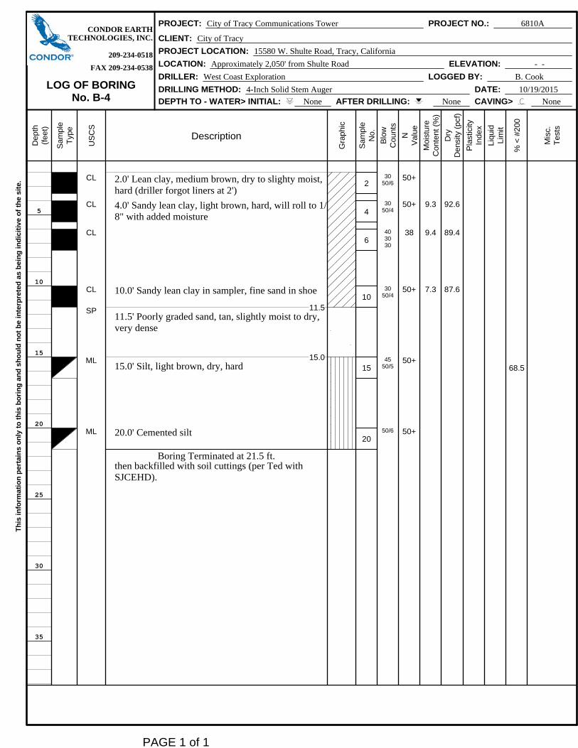
2.0' Lean clay, medium brown, dry to slighty moist,hard (driller forgot liners at 2')
4.0' Sandy lean clay, light brown, hard, will roll to 1/8" with added moisture
10.0' Sandy lean clay in sampler, fine sand in shoe
11.511.5' Poorly graded sand, tan, slightly moist to dry,very dense
15.015.0' Silt, light brown, dry, hard
20.0' Cemented silt
Boring Terminated at 21.5 ft.then backfilled with soil cuttings (per Ted withSJCEHD).
2
4
6
10
15
20
3050/6
3050/4
403030
3050/4
4550/5
50/6
50+
50+
38
50+
50+
50+
9.3
9.4
7.3
92.6
89.4
87.6
68.5
CONDOR EARTHPROJECT: City of Tracy Communications Tower PROJECT NO.: 6810A
TECHNOLOGIES, INC. CLIENT: City of Tracy
209-234-0518 PROJECT LOCATION: 15580 W. Shulte Road, Tracy, California
FAX 209-234-0538 LOCATION: Approximately 2,050' from Shulte Road ELEVATION: - -
LOG OF BORINGNo. B-4
DRILLER: West Coast Exploration LOGGED BY: B. Cook
DRILLING METHOD: 4-Inch Solid Stem Auger DATE: 10/19/2015
DEPTH TO - WATER> INITIAL: None AFTER DRILLING: None CAVING> None
Dep
th(f
eet)
Sam
ple
Typ
e
US
CS
Description
Gra
phi
c
Sam
ple
No.
Blo
wC
ount
s
NV
alu
e
Moi
sture
Con
tent
(%
)
Dry
Den
sity
(pc
f)
Pla
stic
ityIn
dex
Liqu
idLi
mit
% <
#200
Mis
c.T
ests
Th
is in
form
ati
on
per
tain
s o
nly
to
th
is b
ori
ng
an
d s
ho
uld
no
t b
e in
terp
rete
d a
s b
ein
g in
dic
itiv
e o
f th
e s
ite.
PAGE 1 of 1
5
10
15
20
25
30
35
CL
CL
CL
ML
SM
CL
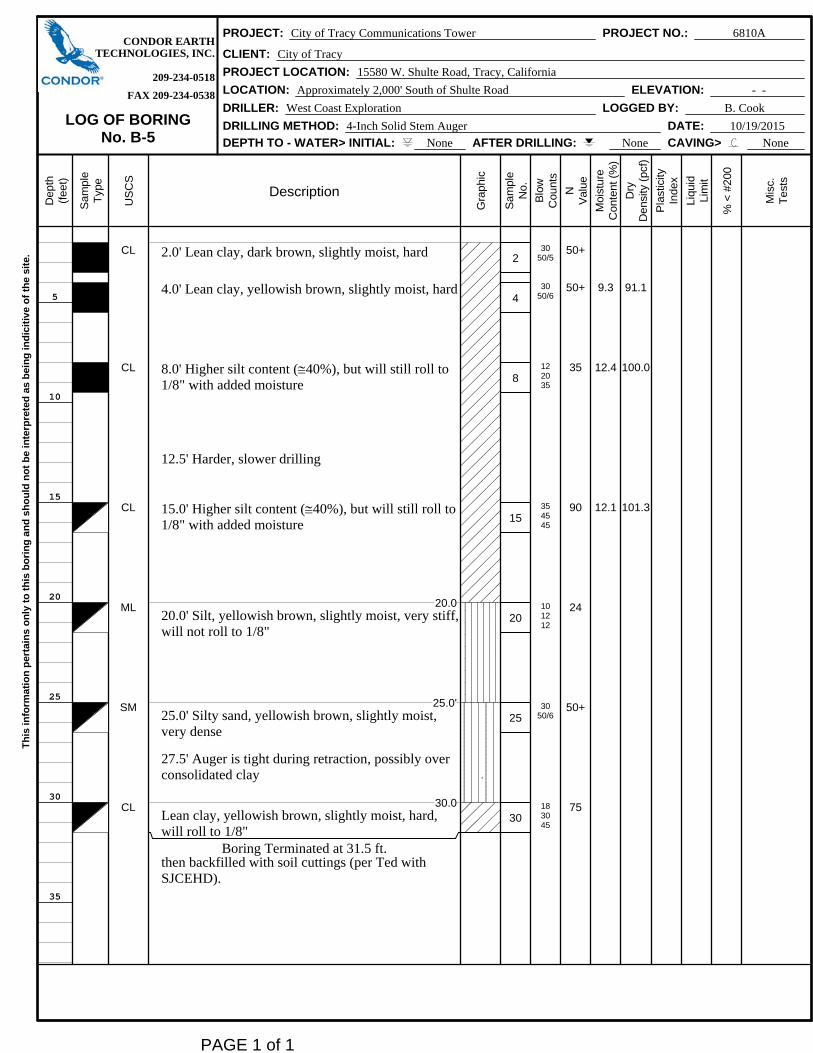
2.0' Lean clay, dark brown, slightly moist, hard
4.0' Lean clay, yellowish brown, slightly moist, hard
8.0' Higher silt content (40%), but will still roll to1/8" with added moisture
12.5' Harder, slower drilling
15.0' Higher silt content (40%), but will still roll to1/8" with added moisture
20.020.0' Silt, yellowish brown, slightly moist, very stiff,will not roll to 1/8"
25.0'25.0' Silty sand, yellowish brown, slightly moist,very dense
27.5' Auger is tight during retraction, possibly overconsolidated clay
30.0Lean clay, yellowish brown, slightly moist, hard,will roll to 1/8"
Boring Terminated at 31.5 ft.then backfilled with soil cuttings (per Ted withSJCEHD).
2
4
8
15
20
25
30
3050/5
3050/6
122035
354545
101212
3050/6
183045
50+
50+
35
90
24
50+
75
9.3
12.4
12.1
91.1
100.0
101.3
CONDOR EARTHPROJECT: City of Tracy Communications Tower PROJECT NO.: 6810A
TECHNOLOGIES, INC. CLIENT: City of Tracy
209-234-0518 PROJECT LOCATION: 15580 W. Shulte Road, Tracy, California
FAX 209-234-0538 LOCATION: Approximately 2,000' South of Shulte Road ELEVATION: - -
LOG OF BORINGNo. B-5
DRILLER: West Coast Exploration LOGGED BY: B. Cook
DRILLING METHOD: 4-Inch Solid Stem Auger DATE: 10/19/2015
DEPTH TO - WATER> INITIAL: None AFTER DRILLING: None CAVING> None
Dep
th(f
eet)
Sam
ple
Typ
e
US
CS
Description
Gra
phi
c
Sam
ple
No.
Blo
wC
ount
s
NV
alu
e
Moi
sture
Con
tent
(%
)
Dry
Den
sity
(pc
f)
Pla
stic
ityIn
dex
Liqu
idLi
mit
% <
#200
Mis
c.T
ests
Th
is in
form
ati
on
per
tain
s o
nly
to
th
is b
ori
ng
an
d s
ho
uld
no
t b
e in
terp
rete
d a
s b
ein
g in
dic
itiv
e o
f th
e s
ite.
PAGE 1 of 1
1. These logs are subject to limitations, conclusions, and recommendations inthis report.
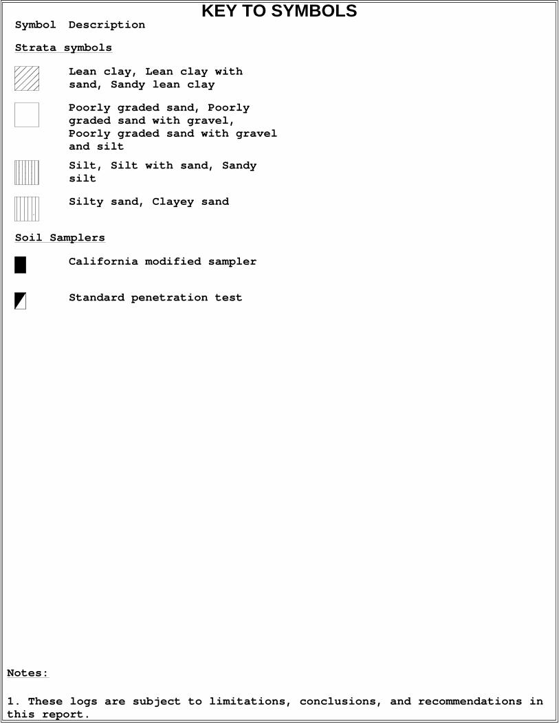
Notes:
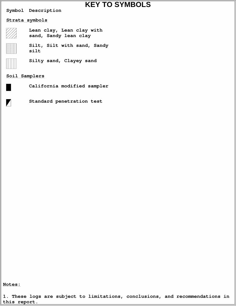
Symbol Description
Strata symbols
Lean clay, Lean clay withsand, Sandy lean clay
Poorly graded sand, Poorlygraded sand with gravel,Poorly graded sand with graveland silt
Silt, Silt with sand, Sandysilt
Silty sand, Clayey sand
Soil Samplers
California modified sampler
Standard penetration test
KEY TO SYMBOLS
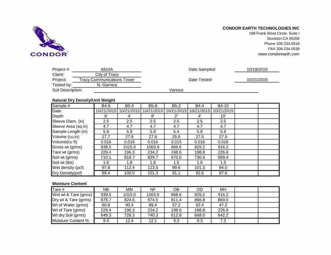
CONDOR EARTH TECHNOLOGIES INC188 Frank West Circle, Suite I
Stockton CA 95206
Phone 209.234.0518
FAX 209.234.0538
www.condorearth.com
Project #:Client:Project:Tested by:
Natural Dry Density/Unit Weight
Sample # B4-6 B5-4 B5-8 B5-2 B4-4 B4-10Date 10/21/2015 10/21/2015 10/21/2015 10/21/2015 10/21/2015 10/21/2015Depth 6' 4' 8' 2' 4' 10'Sleeve Diam. (in) 2.5 2.5 2.5 2.5 2.5 2.5Sleeve Area (sq in) 4.7 4.7 4.7 4.7 4.7 4.7Sample Length (in) 5.9 5.9 5.9 5.4 5.8 5.9Volume (cu.in) 27.7 27.8 27.8 25.6 27.5 27.9Volume(cu ft) 0.016 0.016 0.016 0.015 0.016 0.016Gross wt (grms) 939.5 1015.0 1063.9 868.6 929.2 916.2Tare wt (grms) 229.4 196.3 234.2 198.6 198.8 226.8Soil wt (grms) 710.1 818.7 829.7 670.0 730.4 689.4Soil wt (lbs) 1.6 1.8 1.8 1.5 1.6 1.5Wet density (pcf) 97.8 112.4 113.5 99.6 101.3 94.0
Dry Density(pcf) 89.4 100.0 101.3 91.1 92.6 87.6
Moisture Content
Tare # NB MM NF OB OD MHWet wt & Tare (grms) 939.5 1015.0 1063.9 868.6 929.2 916.2Dry wt & Tare (grms) 878.7 924.6 974.5 811.4 866.8 869.0Wt of Water (grms) 60.8 90.4 89.4 57.2 62.4 47.2Wt of Tare (grms) 229.4 196.3 234.2 198.6 198.8 226.8Wt dry Soil (grms) 649.3 728.3 740.3 612.8 668.0 642.2
Moisture Content % 9.4 12.4 12.1 9.3 9.3 7.3
Various
6810ACity of Tracy
Tracy Communications TowerN. Garnica
Date Sampled:
Date Tested:
Soil Description:
10/19/2015
10/21/2015

Tested By: N. Garnica Checked By: R. Long
CONDOREARTH TECHNOLOGIES
Jamestown, CA
10/21/15
(no specification provided)
PL= LL= PI=
D90= D85= D60=D50= D30= D15=D10= Cu= Cc=
USCS= AASHTO=
*
Tan Sandy Silt1-1/2"
1"3/4"1/2"3/8"#4#8#16#30#50
#100#200
100.0100.0100.0100.0100.0100.0
99.499.198.393.082.468.5
ML
Sampled by B. Cook on 10/19/15
City of Tracy
Tracy Communications Tower
6810A
Material Description
Atterberg Limits
Coefficients
Classification
Remarks
Location: B4-15Sample Number: SA-1 Date:
Client:
Project:
Project No: Figure
SIEVE PERCENT SPEC.* PASS?
SIZE FINER PERCENT (X=NO)
PE
RC
EN
T F
INE
R
0
10
20
30
40
50
60
70
80
90
100
GRAIN SIZE - mm.
0.0010.010.1110100
% +3"Coarse
% Gravel
Fine Coarse Medium
% Sand
Fine Silt
% Fines
Clay
100.0
6 in.
3 in.
2 in.
1½
in.
1 in.
¾ in.
½ in.
3/8
in.
#4
#10
#20
#30
#40
#60
#100
#140
#200
Particle Size Distribution Report


APPENDIX A
FIGURES


+
+
+
+
+
++
+
+
+
+
+
+
+
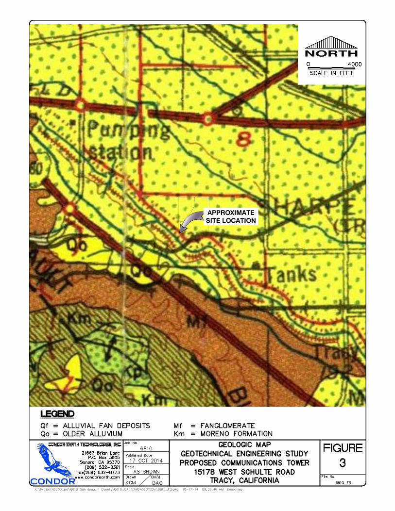
Great Valley 7
Great Valley 8Mt. Diablo Fault
APPROXIMATESITE LOCATION
Green Valley FaultConcord Fault
Fresno
Monterey
Madera
Merced
Tuolumne
Yolo El Dorado
Mariposa
Stanislaus
Napa
San Benito
Solano
San Joaquin
Alpine
Santa Clara
Sutter
Calaveras
Douglas
Sacramento
Alameda
Amador
Contra Costa
San Mateo
Santa Cruz
San Francisco
Hayward Fault
Calaveras Fault
San Andreas Fault
San Andreas Fault
Hayward Fault
San Andreas Fault
San Andreas Fault
San Andreas Fault
Ortigalita Fault
Calaveras FaultGreenville Fault
Ortigalita Fault
Vaca Fault
Vernalis Fault
Foothill Fault
Foothill Fault
CONDOR EARTH TECHNOLOGIES, INC.
.
0 30
Scale in Kilometers
REPRODUCED WITH PERMISSION, DIVISION MINES AND GEOLOGY, CD-ROM 2000-2006 (2000), DIGITAL DATABASE OF FAULTS FROM THE FAULT ACTIVITY MAP OF CALIFORNIA AND ADJACENT AREAS. THRUST FAULT LOCATIONS FROM PETERSEN et. al. 1996 AND WGGEP 2003
Pre-QuaternaryQuaternary
Approximate LocationConcealed
+ +Blind Thrust FaultShowing Rupture Topand Hachures IndicateDip Direction
FAULTS
Late QuaternaryHoloceneHistoric
Legend
Well Located
KGM BACChk'dDrawn
Scale
Job No.
Published Data6810
17 OCT 2014
File No.
FIGURE4
6810_F4.mxd
AS SHOWN
21663 Brian LaneP.O. Box 3905
Sonora, CA 95370(209) 532-0361
fax (209) 532-0773www.condorearth.com
X:\GIS\6000_PRJ\6810_Comm_Tower\MXD\
REGIONAL FAULT MAPGEOTECHNICAL ENGINEERING STUDY
PROPOSEDCOMMUNICATIONS TOWER
TRACY, CALIFORNIA

APPENDIX B
LOGS OF BORINGS
0
5
10
15
20
25
30
35
CL
CL
ML
SM
CL
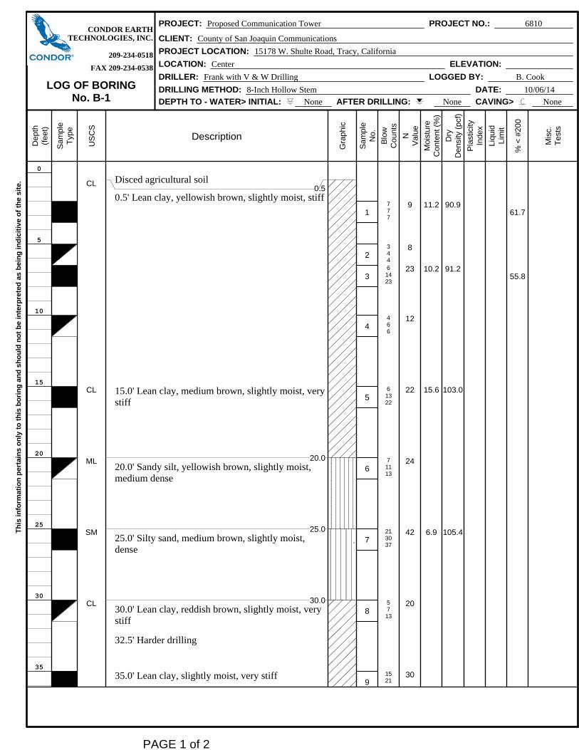
Disced agricultural soil0.5
0.5' Lean clay, yellowish brown, slightly moist, stiff
15.0' Lean clay, medium brown, slightly moist, verystiff
20.020.0' Sandy silt, yellowish brown, slightly moist,medium dense
25.025.0' Silty sand, medium brown, slightly moist,dense
30.030.0' Lean clay, reddish brown, slightly moist, verystiff
32.5' Harder drilling
35.0' Lean clay, slightly moist, very stiff
1
2
3
4
5
6
7
8
9
777
34461423
466
61322
71113
213037
5713
1521
9
8
23
12
22
24
42
20
30
11.2
10.2
15.6
6.9
90.9
91.2
103.0
105.4
61.7
55.8
CONDOR EARTHPROJECT: Proposed Communication Tower PROJECT NO.: 6810
TECHNOLOGIES, INC. CLIENT: County of San Joaquin Communications
209-234-0518 PROJECT LOCATION: 15178 W. Shulte Road, Tracy, California
FAX 209-234-0538 LOCATION: Center ELEVATION:
LOG OF BORINGNo. B-1
DRILLER: Frank with V & W Drilling LOGGED BY: B. Cook
DRILLING METHOD: 8-Inch Hollow Stem DATE: 10/06/14
DEPTH TO - WATER> INITIAL: None AFTER DRILLING: None CAVING> None
Dep
th(f
eet)
Sam
ple
Typ
e
US
CS
Description
Gra
phi
c
Sam
ple
No.
Blo
wC
ount
s
NV
alu
e
Moi
sture
Con
tent
(%
)
Dry
Den
sity
(pc
f)
Pla
stic
ityIn
dex
Liqu
idLi
mit
% <
#200
Mis
c.T
ests
Th
is in
form
ati
on
per
tain
s o
nly
to
th
is b
ori
ng
an
d s
ho
uld
no
t b
e in
terp
rete
d a
s b
ein
g in
dic
itiv
e o
f th
e s
ite.
PAGE 1 of 2
40
45
50
55
60
65
70
CL
CL
CL
40.0' Lean clay, yellowish brown, slightly moist,stiff
Boring Terminated at 51.5 ft. Backfilled with lean cement
10
11
12
27
669
91120
91723
15
20
40
CONDOR EARTHPROJECT: Proposed Communication Tower PROJECT NO.: 6810
TECHNOLOGIES, INC. CLIENT: County of San Joaquin Communications
209-234-0518 PROJECT LOCATION: 15178 W. Shulte Road, Tracy, California
FAX 209-234-0538 LOCATION: Center ELEVATION:
LOG OF BORINGNo. B-1
DRILLER: Frank with V & W Drilling LOGGED BY: B. Cook
DRILLING METHOD: 8-Inch Hollow Stem DATE: 10/06/14
DEPTH TO - WATER> INITIAL: None AFTER DRILLING: None CAVING> None
Dep
th(f
eet)
Sam
ple
Typ
e
US
CS
Description
Gra
phi
c
Sam
ple
No.
Blo
wC
ount
s
NV
alu
e
Moi
sture
Con
tent
(%
)
Dry
Den
sity
(pc
f)
Pla
stic
ityIn
dex
Liqu
idLi
mit
% <
#200
Mis
c.T
ests
Th
is in
form
ati
on
per
tain
s o
nly
to
th
is b
ori
ng
an
d s
ho
uld
no
t b
e in
terp
rete
d a
s b
ein
g in
dic
itiv
e o
f th
e s
ite.
PAGE 2 of 2
0
5
10
15
20
25
30
35
CL
CL
CL
SM
ML
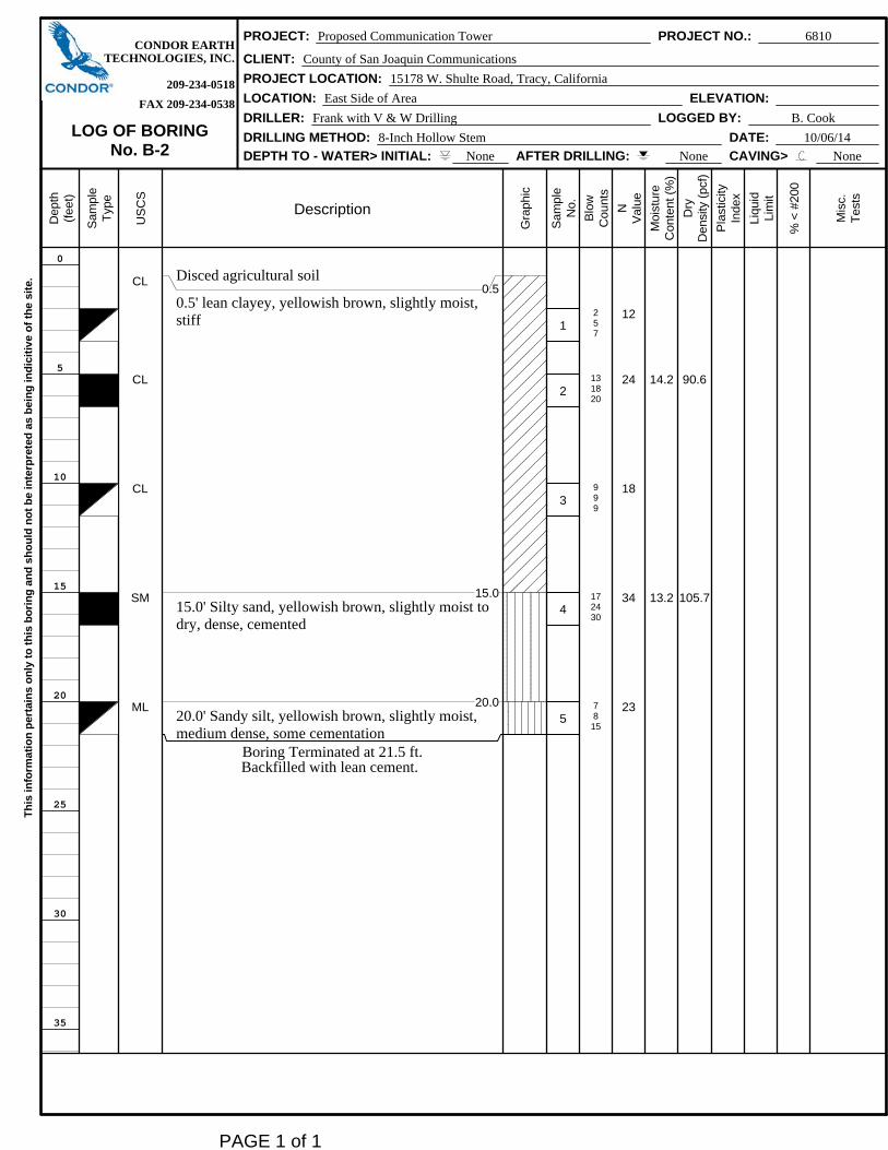
Disced agricultural soil0.5
0.5' lean clayey, yellowish brown, slightly moist,stiff
15.015.0' Silty sand, yellowish brown, slightly moist todry, dense, cemented
20.020.0' Sandy silt, yellowish brown, slightly moist,medium dense, some cementation
Boring Terminated at 21.5 ft. Backfilled with lean cement.
1
2
3
4
5
257
131820
999
172430
7815
12
24
18
34
23
14.2
13.2
90.6
105.7
CONDOR EARTHPROJECT: Proposed Communication Tower PROJECT NO.: 6810
TECHNOLOGIES, INC. CLIENT: County of San Joaquin Communications
209-234-0518 PROJECT LOCATION: 15178 W. Shulte Road, Tracy, California
FAX 209-234-0538 LOCATION: East Side of Area ELEVATION:
LOG OF BORINGNo. B-2
DRILLER: Frank with V & W Drilling LOGGED BY: B. Cook
DRILLING METHOD: 8-Inch Hollow Stem DATE: 10/06/14
DEPTH TO - WATER> INITIAL: None AFTER DRILLING: None CAVING> None
Dep
th(f
eet)
Sam
ple
Typ
e
US
CS
Description
Gra
phi
c
Sam
ple
No.
Blo
wC
ount
s
NV
alu
e
Moi
sture
Con
tent
(%
)
Dry
Den
sity
(pc
f)
Pla
stic
ityIn
dex
Liqu
idLi
mit
% <
#200
Mis
c.T
ests
Th
is in
form
ati
on
per
tain
s o
nly
to
th
is b
ori
ng
an
d s
ho
uld
no
t b
e in
terp
rete
d a
s b
ein
g in
dic
itiv
e o
f th
e s
ite.
PAGE 1 of 1

0
5
10
15
20
25
30
35
CL
CL
ML
ML
ML
Disced agricultural soil0.5
0.5' Lean Clay, yellowish brown, slightly moist, stiff
10.010.0' Silt, yellowish brown, slightly moist, mediumdense
Boring Terminated at 21.5 ft. Backfilled with lean cement.
1
2
3
4
5
889
8914
51016
4712
81722
11
23
16
19
25
11.4 100.4 29 47
Direct Shear:=28.2
CONDOR EARTHPROJECT: Proposed Communication Tower PROJECT NO.: 6810
TECHNOLOGIES, INC. CLIENT: County of San Joaquin Communications
209-234-0518 PROJECT LOCATION: 15178 W. Shulte Road, Tracy, California
FAX 209-234-0538 LOCATION: West Side of Site ELEVATION:
LOG OF BORINGNo. B-3
DRILLER: Frank with V & W Drilling LOGGED BY: B. Cook
DRILLING METHOD: 8-Inch Hollow Stem DATE: 10/06/14
DEPTH TO - WATER> INITIAL: None AFTER DRILLING: None CAVING> None
Dep
th(f
eet)
Sam
ple
Typ
e
US
CS
Description
Gra
phi
c
Sam
ple
No.
Blo
wC
ount
s
NV
alu
e
Moi
sture
Con
tent
(%
)
Dry
Den
sity
(pc
f)
Pla
stic
ityIn
dex
Liqu
idLi
mit
% <
#200
Mis
c.T
ests
Th
is in
form
ati
on
per
tain
s o
nly
to
th
is b
ori
ng
an
d s
ho
uld
no
t b
e in
terp
rete
d a
s b
ein
g in
dic
itiv
e o
f th
e s
ite.
PAGE 1 of 1
1. These logs are subject to limitations, conclusions, and recommendations inthis report.
Notes:
Symbol Description
Strata symbols
Lean clay, Lean clay withsand, Sandy lean clay
Silt, Silt with sand, Sandysilt
Silty sand, Clayey sand
Soil Samplers
California modified sampler
Standard penetration test
KEY TO SYMBOLS

APPENDIX C
RESULTS OF LABORATORY TESTS

Tested By: N.Garnica Checked By: R. Long
CONDOREARTH TECHNOLOGIES, INC.
Stockton, California
Client:Project:
Project No.: Figure
San Joaquin County Information Systems Division
Proposed Communications Tower Project
6810
SYMBOL SOURCE
NATURAL
USCSSAMPLE DEPTH WATER PLASTIC LIQUID PLASTICITY
NO. CONTENT LIMIT LIMIT INDEX(%) (%) (%) (%)
SOIL DATA
PL
AS
TIC
ITY
IND
EX
0
10
20
30
40
50
60
LIQUID LIMIT0 10 20 30 40 50 60 70 80 90 100 110
CL-ML
CL or O
L
CH or O
H
ML or OL MH or OH
Dashed line indicates the approximateupper limit boundary for natural soils
4
7
LIQUID AND PLASTIC LIMITS TEST REPORT
PI-B3 3' 18 47 29 CL
Tested By: N. Garnica Checked By: R. Long
CONDOREARTH TECHNOLOGIES, INC.
Stockton, California
10/17/14
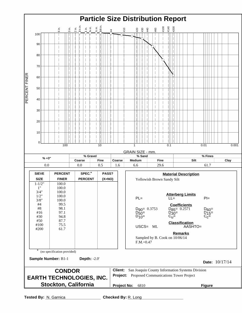
(no specification provided)
PL= LL= PI=
D90= D85= D60=D50= D30= D15=D10= Cu= Cc=
USCS= AASHTO=
*
Yellowish Brown Sandy Silt1-1/2"
1"3/4"1/2"3/8"#4#8
#16#30#50#100#200
100.0100.0100.0100.0100.0
99.598.197.194.887.775.561.7
0.3753 0.2571
ML
Sampled by B. Cook on 10/06/14F.M.=0.47
San Joaquin County Information Systems Division
Proposed Communications Tower Project
6810
Material Description
Atterberg Limits
Coefficients
Classification
Remarks
Sample Number: B1-1 Depth: -2.0'Date:
Client:Project:
Project No: Figure
SIEVE PERCENT SPEC.* PASS?
SIZE FINER PERCENT (X=NO)
PE
RC
EN
T F
INE
R
0
10
20
30
40
50
60
70
80
90
100
GRAIN SIZE - mm.
0.0010.010.1110100
% +3"Coarse
% Gravel
Fine Coarse Medium
% Sand
Fine Silt
% Fines
Clay
0.0 0.0 0.5 1.6 6.6 29.6 61.7
6 in
.
3 in
.
2 in
.
1½ in
.
1 in
.
¾ in
.
½ in
.
3/8
in.
#4 #10
#20
#30
#40
#60
#100
#140
#200
Particle Size Distribution Report

Tested By: N. Garnica Checked By: R. Long
CONDOREARTH TECHNOLOGIES, INC.
Stockton, California
10/17/14
(no specification provided)
PL= LL= PI=
D90= D85= D60=D50= D30= D15=D10= Cu= Cc=
USCS= AASHTO=
*
Light Brown Sandy Silt1-1/2"
1"3/4"1/2"3/8"#4#8
#16#30#50#100#200
100.0100.0100.0100.0100.0
99.096.495.192.285.572.655.8
0.4776 0.2921 0.0893
ML
Sampled by B. Cook on 10/06/14F.M.=0.59
San Joaquin County Information Systems Division
Proposed Communications Tower Project
6810
Material Description
Atterberg Limits
Coefficients
Classification
Remarks
Sample Number: B1-3 Depth: -6.5'Date:
Client:Project:
Project No: Figure
SIEVE PERCENT SPEC.* PASS?
SIZE FINER PERCENT (X=NO)
PE
RC
EN
T F
INE
R
0
10
20
30
40
50
60
70
80
90
100
GRAIN SIZE - mm.
0.0010.010.1110100
% +3"Coarse
% Gravel
Fine Coarse Medium
% Sand
Fine Silt
% Fines
Clay
0.0 0.0 1.0 2.9 7.2 33.1 55.8
6 in
.
3 in
.
2 in
.
1½ in
.
1 in
.
¾ in
.
½ in
.
3/8
in.
#4 #10
#20
#30
#40
#60
#100
#140
#200
Particle Size Distribution Report
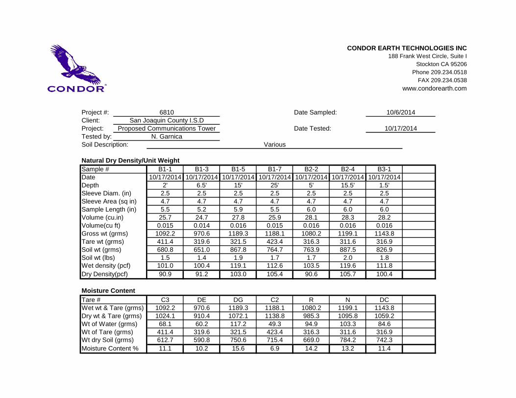
CONDOR EARTH TECHNOLOGIES INC188 Frank West Circle, Suite I
Stockton CA 95206
Phone 209.234.0518
FAX 209.234.0538
www.condorearth.com
Project #:Client:Project:Tested by:
Natural Dry Density/Unit Weight
Sample # B1-1 B1-3 B1-5 B1-7 B2-2 B2-4 B3-1Date 10/17/2014 10/17/2014 10/17/2014 10/17/2014 10/17/2014 10/17/2014 10/17/2014Depth 2' 6.5' 15' 25' 5' 15.5' 1.5'Sleeve Diam. (in) 2.5 2.5 2.5 2.5 2.5 2.5 2.5Sleeve Area (sq in) 4.7 4.7 4.7 4.7 4.7 4.7 4.7Sample Length (in) 5.5 5.2 5.9 5.5 6.0 6.0 6.0Volume (cu.in) 25.7 24.7 27.8 25.9 28.1 28.3 28.2Volume(cu ft) 0.015 0.014 0.016 0.015 0.016 0.016 0.016Gross wt (grms) 1092.2 970.6 1189.3 1188.1 1080.2 1199.1 1143.8Tare wt (grms) 411.4 319.6 321.5 423.4 316.3 311.6 316.9Soil wt (grms) 680.8 651.0 867.8 764.7 763.9 887.5 826.9Soil wt (lbs) 1.5 1.4 1.9 1.7 1.7 2.0 1.8Wet density (pcf) 101.0 100.4 119.1 112.6 103.5 119.6 111.8
Dry Density(pcf) 90.9 91.2 103.0 105.4 90.6 105.7 100.4
Moisture Content
Tare # C3 DE DG C2 R N DCWet wt & Tare (grms) 1092.2 970.6 1189.3 1188.1 1080.2 1199.1 1143.8Dry wt & Tare (grms) 1024.1 910.4 1072.1 1138.8 985.3 1095.8 1059.2Wt of Water (grms) 68.1 60.2 117.2 49.3 94.9 103.3 84.6Wt of Tare (grms) 411.4 319.6 321.5 423.4 316.3 311.6 316.9Wt dry Soil (grms) 612.7 590.8 750.6 715.4 669.0 784.2 742.3
Moisture Content % 11.1 10.2 15.6 6.9 14.2 13.2 11.4
Various
6810San Joaquin County I.S.D
Proposed Communications TowerN. Garnica
Date Sampled:
Date Tested:
Soil Description:
10/6/2014
10/17/2014