Embed Size (px)
Citation preview
REVISED NOTICE OF PREPARATION (NOP) OF A DRAFT ENVIRONMENTAL IMPACT REPORT (EIR)
FOR TENTATIVE TRACT 5475, A 74-UNIT RESIDENTIAL DEVELOPMENT AT FOOTHILL AND PECK
DATE: November 10, 2011 SUBJECT: Comment Period for Tentative Tract 5475 EIR NOP
Tentative Tract 5475 EIR; State Clearinghouse No. 2007071108
Del Investment Fund No. 9, Ltd.
Project Contact: Stratis Perros, Deputy Planning Director Phone: (805) 933-4214 Fax: (805) 525-6660
The City of Santa Paula intends to prepare an Environmental Impact Report for the Tentative Tract Map 5475. In
accordance with Section 15082 of the State CEQA Guidelines, the City of Santa Paula has prepared this Notice of
Preparation to provide Responsible Agencies and other interested parties with information describing the proposal
and its potential environmental effects.
On July 19, 2007, a Notice of Preparation (NOP) for the proposed project was distributed to the State
Clearinghouse, responsible agencies, and interested parties for a 30-day review period that ended on August 23,
2007. This revised NOP is being circulated because the project has been revised to include export of net cut from
the site along public roadways. Grading volumes have also changed, as noted in the project description, below.
The revised NOP also provides an opportunity for commenting agencies to provide input on any new or changed
requirements.
Environmental factors which would be potentially affected by the revised project are:
(1) Aesthetics; (2) Biological Resources; (3) Cultural Resources; (4) Geology/Soils; (5) Greenhouse Gas
Emissions; (6) Hazards and Hazardous Materials; (7) Hydrology/Water Quality; (8) Noise; (9)
Transportation/Traffic; and (10) Mandatory Findings of Significance.
PROJECT LOCATION: Northwest Corner of Peck Road and Foothill Road
PROJECT DESCRIPTION: The proposed project involves development of a 32.5-acre site for a fully graded hillside subdivision. The project is proposed with 74 hillside residential building lots averaging 9,685 square feet. Public streets would be built to serve the residential development according to city standards. Virtually all of the site would be subject to excavation or fill with additional extensive grading occurring off-site. On-site remedial grading would involve the removal and recompaction of approximately 1.2 million cubic yards of soil, as well as 370,000 cubic yards of surface grading for the roads and home pads. The offsite grading plan would include provisions for the removal and hauling of the project’s approximately 750,000 cubic yards of cut as well as grading to stabilize on-site and surrounding slopes. Each lot would have a graded pad of sufficient size for construction of a conventional one or two story home. Proposed lot sizes would range from 6,499 square feet to 16,599 square feet. The majority of the homes would be developer-built detached single-family houses. Some lots may be reserved for custom home construction.
CITY OF SANTA PAULA PLANNING DEPARTMENT
200 S. 10th
STREET SANTA PAULA, CALIFORNIA 93060
Project Title:
Applicant:
A drainage system is proposed, along with on- and off-site grading. The proposed drainage system has two main purposes: to protect the project from water flowing off the hillside above, and to control the water flowing off of the project itself. The proposed project includes the construction of two storm water detention basins to capture high intensity, short duration rainfall. The internal drainage will be collected by the streets and by a system of pipes and concrete channels on other areas of the site. The water will be directed to the southeast corner of the site (closest to the Peck and Foothill intersection), prior to release into the storm drain along Peck Road. The detention basins would be designed to prevent overloading of the downstream facilities and reduce downstream erosion caused by high flows. Proposed utility systems include water, sewer, gas, electricity, telephone and television. Two parks are proposed for use by local residents as well as the public. A 2.76-acre public park designed for active use will be located in the northwest corner of the site. A 4.92-acre passive park will be incorporated into open space along the south and west sides of the project.
The development is proposed for annexation into the City of Santa Paula, and a Specific Plan is also part of
the applicant’s request.
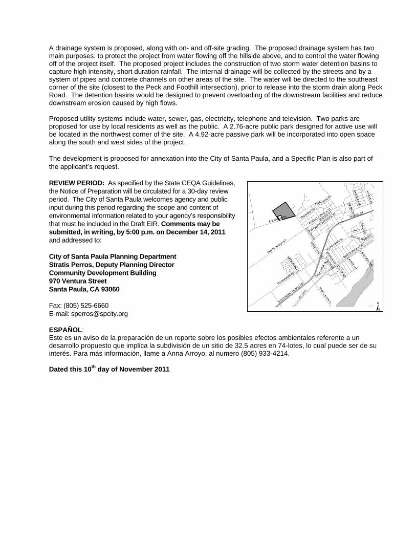
REVIEW PERIOD: As specified by the State CEQA Guidelines,
the Notice of Preparation will be circulated for a 30-day review
period. The City of Santa Paula welcomes agency and public
input during this period regarding the scope and content of
environmental information related to your agency’s responsibility
that must be included in the Draft EIR. Comments may be
submitted, in writing, by 5:00 p.m. on December 14, 2011
and addressed to:
City of Santa Paula Planning Department
Stratis Perros, Deputy Planning Director
Community Development Building
970 Ventura Street
Santa Paula, CA 93060
Fax: (805) 525-6660
E-mail: [email protected]
ESPAÑOL: Este es un aviso de la preparación de un reporte sobre los posibles efectos ambientales referente a un desarrollo propuesto que implica la subdivisión de un sitio de 32.5 acres en 74-lotes, lo cual puede ser de su interés. Para más información, llame a Anna Arroyo, al numero (805) 933-4214.
Dated this 10th
day of November 2011
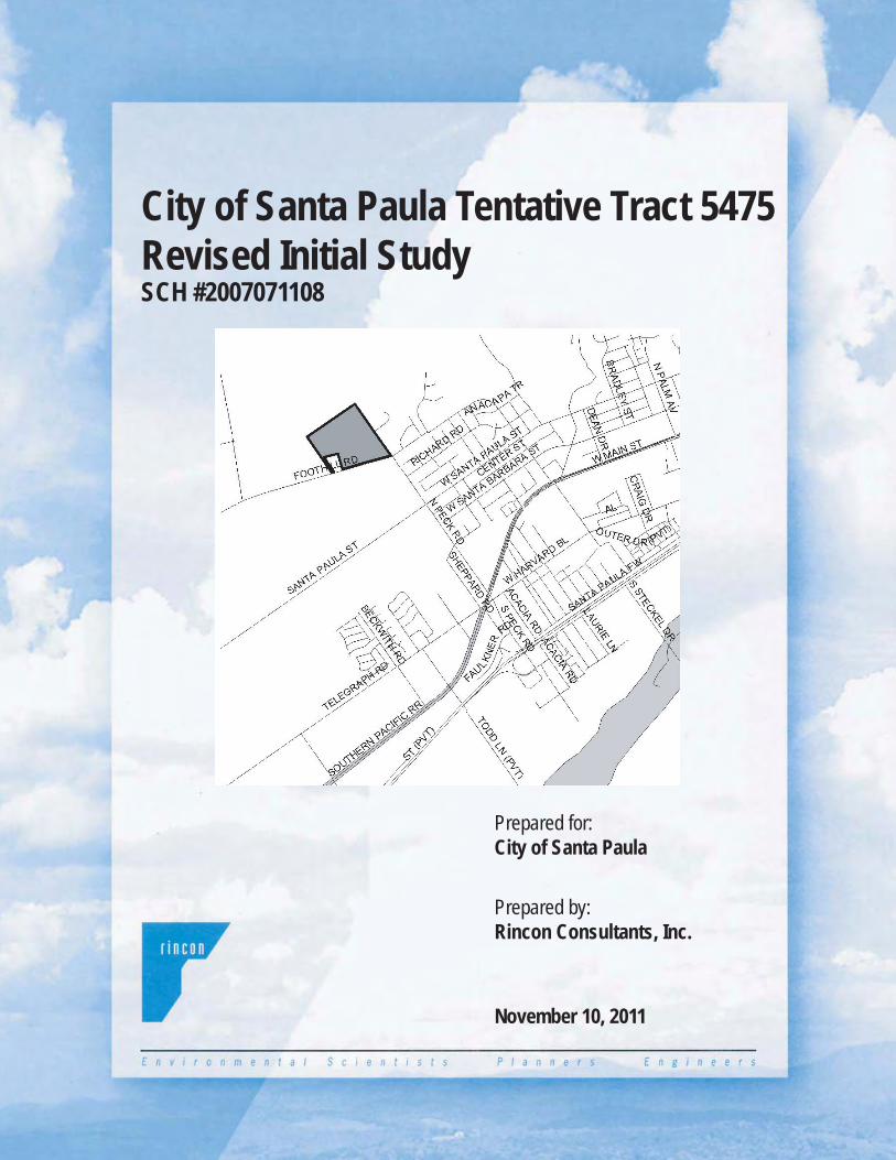
City of Santa Paula Tentative Tract 5475Revised Initial StudySCH #2007071108
Prepared for:City of Santa Paula
Prepared by:Rincon Consultants, Inc.
November 10, 2011
City of Santa Paula Tentative Tract 5475
Revised Initial Study
State Clearinghouse No. 2007071108
Prepared for:
City of Santa Paula 970 Ventura Street
Santa Paula, California 93060
Prepared by:
Rincon Consultants, Inc. 180 N. Ashwood Avenue Ventura, California 93003
November 10, 2011

This report is printed on 50% recycled paper .

Revised Initial Study Tentative Tract 5475 November 10, 2011
City of Santa Paula i
TABLE OF CONTENTS Page
Initial Study 1. Project title ........................................................................................................................... 1 2. Lead agency name and address ....................................................................................... 1 3. Contact person and phone number ................................................................................. 1 4. Project location ................................................................................................................... 1 5. Project sponsor’s name and address ............................................................................... 1
6. General plan designation .................................................................................................. 1 7. Zoning .................................................................................................................................. 1 8. Description of project ........................................................................................................ 3 9. Surrounding land uses and setting .................................................................................. 4 10. Other public agencies whose approval is required ....................................................... 7 Environmental Factors Affected .............................................................................................. 9 Determination ........................................................................................................................... 10 Environmental Checklist ......................................................................................................... 11 Discussion I. Aesthetics ................................................................................................................ 11 II. Agricultural Resources .......................................................................................... 12 III. Air Quality .............................................................................................................. 13 IV. Biological Resources .............................................................................................. 15 V. Cultural Resources ................................................................................................. 16 VI. Geology and Soils .................................................................................................. 17 VII. Greenhouse Gas Emissions .................................................................................. 18 VIII. Hazards and Hazardous Materials ..................................................................... 19 IX. Hydrology and Water Quality ............................................................................. 21 X. Land Use and Planning ......................................................................................... 23 XI. Mineral Resources ................................................................................................. 24 XII. Noise ........................................................................................................................ 24 XIII. Population and Housing ....................................................................................... 25 XIV. Public Services ........................................................................................................ 26 XV. Recreation ............................................................................................................... 28 XVI. Transportation/Traffic .......................................................................................... 29 XVII. Utilities and Service Systems ............................................................................... 31 XVIII. Mandatory Findings of Significance ................................................................... 33 References ................................................................................................................................. 34 Figures Figure 1 Project Vicinity Map ................................................................................................ 2 Figure 2 Tentative Tract Map ................................................................................................. 5 Figure 3 Potential Off-Site Fill Areas .................................................................................... 8

Revised Initial Study Tentative Tract 5475 November 10, 2011
City of Santa Paula ii
This page intentionally left blank.

Revised Initial Study Tentative Tract 5475 November 10, 2011
City of Santa Paula 1
INITIAL STUDY 1. Project title: Tentative Tract 5475, also known as the Peck/Foothill Road Development Project
(SCH # 2007071108)
2. Lead agency name and address:
City of Santa Paula 970 Ventura Street Santa Paula, Ca 93060
3. Contact person and phone number:
Stratis Perros, Deputy Planning Director (805) 933-4214
4. Project location: The project site includes 32.5 undeveloped hillside acres at the northwest corner of the intersection of Peck Road and Foothill Road. The site is immediately outside the present boundary of the City of Santa Paula but within the City Urban Restriction Boundary (CURB) line. The site location is shown on Figure 1.
5. Project sponsor’s name and address:
Del Investment Fund No. 9, Ltd. 670 N. Conejo School Road Thousand Oaks , CA 91362 Contact: Michael Piszker
6. General Plan designation: The City of Santa Paula General Plan designates the site as part of the Adams Canyon Expansion Area, which is within the CURB line and which provides for 495 dwelling units. Prior to annexation, the City would consider a Specific Plan which would establish land uses for the site.
7. Zoning: The project site is currently zoned Agriculture Exclusive (AE) – 40 acre by the County of
Ventura and is within the City’s Adams Canyon Expansion Area. The site is proposed for annexation to the City of Santa Paula and would be prezoned to SP-1 Adams Canyon, in accordance with Santa Paula Municipal Code Section 16.25.020.

Initial StudyTentative Tract 5475
Vicinity Map Figure 1City of Santa Paula
November 10, 2011
2

Revised Initial Study Tentative Tract 5475 November 10, 2011
City of Santa Paula 3
8. Description of project:
The proposed project involves development of a 32.5-acre site for a fully graded hillside subdivision (Figure 2). The project is proposed with 74 hillside residential building lots averaging 9,685 square feet. Public streets, or private streets to the City’s public street standards, would be built to serve the residential development according to city standards. The proposed arrangement of lots and streets is dictated by the shape of the existing hillside adjacent to the site. Each lot would have a graded pad of sufficient size for construction of a conventional one or two story home. The future homes would be developer-built detached single family houses. Some lots may be reserved for custom home construction.
Virtually all of the site would be subject to excavation or fill with additional grading occurring off-site. On-site remedial grading would involve the removal and recompaction or engineering of approximately 1.2 million cubic yards of soil, as well as 370,000 cubic yards of surface grading for the roads and home pads. Off-site grading will be required at the margins of the development site for additional stabilization of surrounding slopes. The majority of the off-site grading would take place directly north and west of the project site. A total of 750,000 cy of net export will be removed from the site, which would require approximately 57,700 truck trips1 over approximately one year for an average of approximately 220 truck trips per day. The excess soil would be hauled to one or more receiver sites. The applicant has proposed two options for potential receiver sites. Option A, which is the preferred option for the applicant, would utilize multiple receiver sites throughout the area, which would be hauled via City, County, and State roads. Option A receiver sites may include recently approved projects in Ventura County, should such construction and grading on such sites be underway. The nearest site potential receiver site would be approximately 1.5 miles from the project site and the furthest potential receiver site would be approximately 20 miles away. These potential receiver sites include the following. In, addition, should one or more of these potential receiver sites not be able to accept soil, a portion of the exported soil may need to be hauled to the Toland Landfill between Santa Paula and Fillmore.
1 The number of truck trips cited in this section assumes single trucks. If double-bottom haulers are used, the number
of truck trips would be reduced.
Table 1. Potential Soil Receiver Sites
Jurisdiction Project Tent. Tract No. Estimated Fill Quantity
1. City of Santa Paula Santa Paula Air Park TTM 5370 40,000 c.y.
2. City of Santa Paula West Area Two n/a 1,000,000 c.y.
3. Ventura County – Piru Community
Warren Site TTM 5553 40,000 c.y.
4. Ventura County – Piru Community
Finch Site TTM 5683 25,000 c.y.
5. City of Santa Paula Santa Paula West Specific Plan
n/a 175,000 c.y. +

Revised Initial Study Tentative Tract 5475 November 10, 2011
City of Santa Paula 4
Option B would haul the excess soil to canyon areas on a property immediately northwest of the project site (APNs 038-0-090-285 and 038-0-090-295). This adjacent property is owned by Adams Canyon Ranch LLC. Figure 3 depicts the potential fill areas identified on the Adams Canyon Ranch property. The haul route would be a direct route from the project site to the receiver site using existing dirt roads on the hillside, for a length of approximately one quarter-mile each way. The roads would be temporarily widened and then restored to original condition after the hauling is complete. The hauling would be completed using scrapers or off-road trucks, not highway trucks. Soil export would take approximately one year, and remedial grading would take another 6-12 months, for a total duration of grading of approximately 18-24 months. Effective control and treatment of the site is a major consideration for the hillside development. A drainage system is proposed, along with on and off-site grading. The proposed drainage system has two purposes: to protect the project from water flowing off of the hillside above, and to control the water flowing off of the project itself. The proposed project includes the construction of two storm water detention basins, one in the western corner of the site, and the other in the eastern corner of the site, to capture high intensity, short duration rainfall. The internal drainage would be collected by the streets and by a system of pipes and concrete channels on the major slopes. The water would be directed to the southeast corner of the site (Peck and Foothill intersection), prior to release into the storm drain along Peck Road. The detention basins would prevent overloading of the downstream facilities and reduce downstream erosion caused by high flows.
A full compliment of utility systems is proposed including water, sewer, gas, electricity, telephone and television. Two parks are proposed for use by local residents and the public at large. A 2.76-acre public park designed for active use would be located in the northwest corner of the site. A 4.92-acre passive park would be incorporated into open space along the south and west sides of the project.
9. Surrounding land uses and setting:
The 32.5-acre project site is a south facing hillside immediately north of Foothill Road and west of the private northern portion of Peck Road. The site was once planted with avocado trees, but these trees were removed several years ago. Currently, there is no active economic use of the site. However, dirt roads crisscross the hillside through remnants of avocado stumps and unused farm equipment owned by the former tenant. Much of the natural character of the hillside has been degraded by this extensive surface disruption. Two separate single family dwellings neighbor the site to the south along Foothill Road; these units are in the unincorporated area of Ventura County and are zoned Agriculture Exclusive – 40 Acres (AE-40). Across Peck Road to the east of the project site is s an established hillside residential neighborhood. Approximately 37 homes are located along this portion of Peck Road, including 7 that directly abut the project site. The neighboring area is within the Santa Paula city limits and zoned Hillside Residential 2-PD (HR2-PD). Citrus orchards and farmland lie directly to the south across Foothill Road and west of the project site.

Initial StudyTentative Tract 5475
Figure 2City of Santa Paula
Tentative Tract Map 5475
5
Source: Jensen Design & Survey, Inc., 2007
November 10, 2011

Revised Initial Study Tentative Tract 5475 November 10, 2011
City of Santa Paula 7
To the north and west of the site is the 5,413-acre Adams Canyon Expansion Area, which was recently included within the City Urban Restriction Boundary (CURB) line (May 2007). The initiative to include of this area within the CURB incorporated a provision that the maximum build-out of the Adams Canyon area, including the 32.5-acre project site, would be limited to 495 residential units. Hence, with the proposed development of 74 homes on the project site, up to 421 additional homes could be constructed on the Adams Canyon site. The elevation of the site ranges from 300 feet above sea level at the southeast corner to 600 feet above sea level at a point along the north property line. Two relatively flat “mesa” areas dominate the central and eastern portion of the site. A deep ravine and small rounded knoll dominate the west side of the site. Along Foothill Road, the site is planted with a hedge of bougainvillea vines that presents an attractive and colorful view to passing motorists.
10. Other public agencies whose approval is required:
The local agencies with jurisdictional authority over the receiver sites would need to approve the off-site grading, including Ventura County. The Ventura County Local Agency Formation Commission (LAFCO) would need to approve the proposed annexation to the City of Santa Paula.
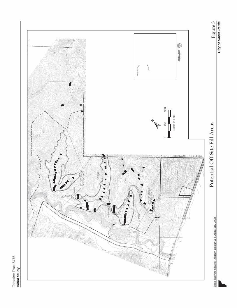
Tent
ativ
e Tr
act 5
475
Initi
al S
tudy
Figu
re 3
City
of S
anta
Pau
la
Pote
ntia
l Off-
Site
Fill
Are
asB
ase
draw
ing
sour
ce:
Jens
en D
esig
n &
Sur
vay,
Inc.
200
8.
/ Sca
le in
Fee
t
0
4
50
9
00

Revised Initial Study Tentative Tract 5475 November 10, 2011
City of Santa Paula 9
ENVIRONMENTAL FACTORS AFFECTED The environmental factors checked below would be potentially affected by this project, involving at least one impact that is “Potentially Significant” or “Potentially Significant Unless Mitigation Incorporated” as indicated by the checklist on the following pages.
Aesthetics Agriculture Resources Air Quality
Biological Resources Cultural Resources Geology/Soils
Greenhouse Gas Emissions
Hazards & Hazardous Materials
Hydrology/Water Quality
Land Use/Planning Mineral Resources Noise
Population/Housing Public Services Recreation
Transportation/Traffic Utilities/Service Systems Mandatory Findings of Significance


Revised Initial Study Tentative Tract 5475 November 10, 2011
City of Santa Paula 11
ENVIRONMENTAL CHECKLIST
I. AESTHETICS – Would the project:
Potentially Significant
Impact
Potentially Significant
Unless Mitigation
Incorporated
Less than Significant
Impact No
Impact
a) Have a substantial adverse effect on a scenic vista?
b) Substantially damage scenic resources, including, but not limited to, trees, rock outcroppings, and historic buildings within a state scenic highway?
c) Substantially degrade the existing visual character or quality of the site and its surroundings?
d) Create a new source of substantial light or glare which would adversely affect day or nighttime views in the area?
a-c. The project site is located in the hillsides above the City of Santa Paula. The site is outside the Santa Paula city limits, but within the City Urban Restriction Boundary (CURB). The proposed project would involve development of a 32.5-acre site for a hillside subdivision with 74 detached single family houses. The development has the potential to affect views from public rights-of-way such as Foothill and Peck Road, West Telegraph Road, and Highway 126. Views from the neighboring hillside community located across Peck Road could also be affected. The project could also result in impacts to scenic resources on the topographically diverse site, thereby degrading the visual character of the site. These issues will be further examined in an EIR. Potentially Significant Unless Mitigation Incorporated d. The proposed site development would include standard residential lighting, including street lights. Such lighting is anticipated to be similar to that associated with adjacent residential developments. All lighting would be required to comply with requirements of Section 16.42.050 of the City of Santa Paula Municipal Code, which specifies that all lights must be directed downwards, oriented and shielded to prevent light from shining onto adjacent properties, onto public rights-of-way, and into driveway areas in a manner that would obstruct drivers' vision. Lighting shall be focused, directed and arranged so as to prevent glare and direct illumination on streets or adjoining property. Compliance with these requirements would minimize impacts to adjacent properties. Therefore, new source of lighting or glare as a result of the project will not have significant impact. Less Than Significant Impact.
Revised Initial Study Tentative Tract 5475 November 10, 2011
City of Santa Paula 12
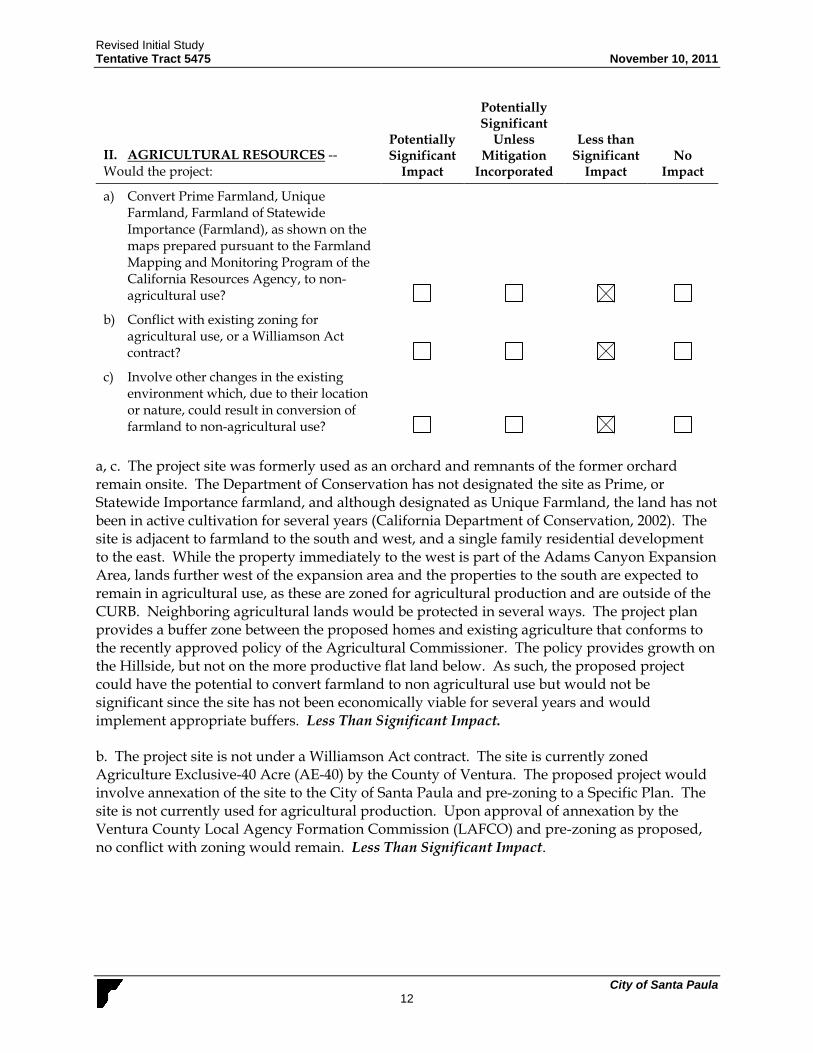
II. AGRICULTURAL RESOURCES -- Would the project:
Potentially Significant
Impact
Potentially Significant
Unless Mitigation
Incorporated
Less than Significant
Impact No
Impact
a) Convert Prime Farmland, Unique Farmland, Farmland of Statewide Importance (Farmland), as shown on the maps prepared pursuant to the Farmland Mapping and Monitoring Program of the California Resources Agency, to non-agricultural use?
b) Conflict with existing zoning for agricultural use, or a Williamson Act contract?
c) Involve other changes in the existing environment which, due to their location or nature, could result in conversion of farmland to non-agricultural use?
a, c. The project site was formerly used as an orchard and remnants of the former orchard remain onsite. The Department of Conservation has not designated the site as Prime, or Statewide Importance farmland, and although designated as Unique Farmland, the land has not been in active cultivation for several years (California Department of Conservation, 2002). The site is adjacent to farmland to the south and west, and a single family residential development to the east. While the property immediately to the west is part of the Adams Canyon Expansion Area, lands further west of the expansion area and the properties to the south are expected to remain in agricultural use, as these are zoned for agricultural production and are outside of the CURB. Neighboring agricultural lands would be protected in several ways. The project plan provides a buffer zone between the proposed homes and existing agriculture that conforms to the recently approved policy of the Agricultural Commissioner. The policy provides growth on the Hillside, but not on the more productive flat land below. As such, the proposed project could have the potential to convert farmland to non agricultural use but would not be significant since the site has not been economically viable for several years and would implement appropriate buffers. Less Than Significant Impact. b. The project site is not under a Williamson Act contract. The site is currently zoned Agriculture Exclusive-40 Acre (AE-40) by the County of Ventura. The proposed project would involve annexation of the site to the City of Santa Paula and pre-zoning to a Specific Plan. The site is not currently used for agricultural production. Upon approval of annexation by the Ventura County Local Agency Formation Commission (LAFCO) and pre-zoning as proposed, no conflict with zoning would remain. Less Than Significant Impact.

Revised Initial Study Tentative Tract 5475 November 10, 2011
City of Santa Paula 13
III. AIR QUALITY -- Would the project:
Potentially Significant
Impact
Potentially Significant
Unless Mitigation
Incorporated
Less than Significant
Impact No
Impact
a) Conflict with or obstruct implementation of the applicable air quality plan?
b) Violate any air quality standard or contribute substantially to an existing or projected air quality violation?
c) Result in a cumulatively considerable net increase of any criteria pollutant for which the project region is non-attainment under an applicable federal or state ambient air quality standard (including releasing emissions which exceed quantitative thresholds for ozone precursors)?
d) Expose sensitive receptors to substantial pollutant concentrations?
e) Create objectionable odors affecting a substantial number of people?
a. The proposed project is located within the South Central Coast Air Basin, which is within the jurisdiction of the Ventura County Air Pollution Control District (APCD). The Ventura County portion of the South Central Coast Air Basin is a state and federal non-attainment area for ozone (1-hour) and a state non-attainment area for suspended particulates (PM10 & PM2.5). Ventura County has been listed as “moderate nonattainment” for the eight-hour ozone standard with an estimated attainment date of June 2010. According to the APCD Guidelines, to be consistent with the Air Quality Management Plan (AQMP), a project must conform to the local general plan and must not result in or contribute to an exceedance of the City’s projected population growth forecast. Project implementation would result in a net increase of 74 residential units on the project site. Based on the current average household size in Santa Paula of 3.526 persons/unit (Ca. Dept. of Finance, 2010), this would generate a net population increase of about 261 people. When added to the citywide population of 30,048 (California Department of Finance, 2010), this would bring the population to 30,309. The APCD’s Air Quality Management Plan considers regional population forecasts developed by the Ventura Council of Governments (VCOG). VCOG forecasted a 2010 population of 32,033 for Santa Paula. Because the population growth associated with proposed project (261 people) is within this growth forecast, it is also within the population growth parameters considered in the AQMP. Project implementation would not likely obstruct implementation of the AQMP.

Revised Initial Study Tentative Tract 5475 November 10, 2011
City of Santa Paula 14
b,c. For the project’s operational phase, the net increase of 74 residential units on the project site would generate a net increase in vehicle traffic estimated at 708 daily trips (based on a rate of 9.57 daily trips/unit – Institute of Transportation Engineers, 2003). The 708-vehicle trip net increase in average daily traffic to and from the site, and the increased energy (electricity and natural gas) consumption associated with the residential development would increase emissions of ozone precursors and other air pollutants. According to APCD’s Air Quality Assessment Guidelines (2007), a project’s daily emissions would be significant if the project would generate more than 25 pounds of ozone precursor’s reactive organic compounds (ROC) or nitrogen oxides (NOx) per day. The APCD Guidelines state that a project involving Single Family Detached Houses would violate the 25 Pound threshold if 134 or more dwelling units were built. Since this proposed project plans to develop only 74 units, the project is within the Guidelines established by APCD. The VCAPCD’s 25 lbs per day thresholds for ROG and NOx also do not apply to construction phase emissions since such emissions are temporary. For construction phase impacts, the VCAPCD recommends imposition of mitigation if emissions of either pollutant exceed 25 pounds per day. The VCAPCD also recommends minimizing fugitive dust through various dust control measures. The extensive grading activities required for project construction could result in an exceedance of criteria pollutant emissions. Grading and export of off-site soils could take up to one-year to complete, and on-site remedial grading would take 6-12 months. The receiver sites could be up to 20 miles away, and the associated truck trips could contribute to local exceedance of air quality standards. Therefore, the proposed project’s impact to air quality standards and the increase in criteria pollutants is potentially significant. Potentially Significant d. Ambient air quality standards have been established to represent the levels of air quality considered sufficient, with an adequate margin of safety, to protect public health and welfare. They are designed to protect that segment of the public most susceptible to respiratory distress, such as children under 14; the elderly over 65; persons engaged in strenuous work or exercise; and people with cardiovascular and chronic respiratory diseases. The majority of sensitive receptor locations are therefore schools and hospitals. The Blanchard Elementary School is 0.5 miles southeast of the project area on Peck Road, and the project site is bordered on the east by residential developments. The construction phase of the proposed project could result in potential impacts to sensitive receptors in the project area due to the extensive grading required. Potentially Significant e. The proposed project would facilitate the development of 74 single family residential units. By their nature, residential uses typically do not generate objectionable odors, nor are there any unusual features of this development that might result in any objectionable odors. No impact would occur, and further analysis of this issue in an EIR is not warranted. No Impact

Revised Initial Study Tentative Tract 5475 November 10, 2011
City of Santa Paula 15
IV. BIOLOGICAL RESOURCES – Would the project:
Potentially Significant
Impact
Potentially Significant
Unless Mitigation
Incorporated
Less than Significant
Impact No
Impact
a) Have a substantial adverse effect, either directly or through habitat modifications, on any species identified as a candidate, sensitive, or special status species in local or regional plans, policies, or regulations, or by the California Department of Fish and Game or U.S. Fish and Wildlife Service?
b) Have a substantial adverse effect on any riparian habitat or other sensitive natural community identified in local or regional plans, policies, or regulations, or by the California Department of Fish and Game or U.S. Fish and Wildlife Service?
c) Have a substantial adverse effect on federally protected wetlands as defined by Section 404 of the Clean Water Act (including, but not limited to, marsh, vernal pool, coastal, etc.) through direct removal, filling, hydrological interruption, or other means?
d) Interfere substantially with the movement of any native resident or migratory fish or wildlife species or with established native resident or migratory wildlife corridors, or impede the use of native wildlife nursery sites?
e) Conflict with any local policies or ordinances protecting biological resources, such as a tree preservation policy or ordinance?
f) Conflict with the provisions of an adopted Habitat Conservation Plan, Natural Community Conservation Plan, or other approved local, regional, or state habitat conservation plan?
a-e. Site development could potentially affect sensitive plant or animal species, wildlife movement. A biological resource evaluation will review existing literature sources to identify the extent of potentially sensitive biological resources known to occur at the study site as well as the deposit site for excavation fill excess. A qualified biologist will survey the project site to determine the presence or absence of special status species, sensitive habitats, and wildlife movement. These issues will be further examined in an EIR. Potentially Significant Unless Mitigation Incorporated

Revised Initial Study Tentative Tract 5475 November 10, 2011
City of Santa Paula 16
f. The project site is not within an area that is subject to an adopted Habitat Conservation Plan, Natural Community Conservation Plan, or other approved conservation plan. No Impact
V. CULTURAL RESOURCES -- Would the project:
Potentially Significant
Impact
Potentially Significant
Unless Mitigation
Incorporated
Less than Significant
Impact No
Impact
a) Cause a substantial adverse change in the significance of a historical resource as defined in §15064.5?
b) Cause a substantial adverse change in the significance of an archaeological resource as defined in §15064.5?
c) Directly or indirectly destroy a unique paleontological resource or site or unique geologic feature?
d) Disturb any human remains, including those interred outside of formal cemeteries?
a. There are no structures or any known historical resources on the site. No impact to historical resources would occur and further analysis of this issue in an EIR is not warranted. No Impact b, d. No known archaeological resources or human remains are known to be present onsite. However, because the site has not been previously surveyed for such resources, there is the potential for as yet undiscovered resources. Impacts to archaeological resources would be potentially significant and will be further examined in an EIR. Potentially Significant Unless Mitigation Incorporated c. No paleontological resources are known to be present onsite and none are expected as the site is not in an area of paleontological sensitivity. The site is occupied by landslide deposits, but these are not considered a unique geologic feature. Further analysis of this issue in an EIR is not warranted. No Impact

Revised Initial Study Tentative Tract 5475 November 10, 2011
City of Santa Paula 17
VI. GEOLOGY AND SOILS – Would the project:
Potentially Significant
Impact
Potentially Significant
Unless Mitigation
Incorporated
Less than Significant
Impact No
Impact
a) Expose people or structures to potential substantial adverse effects, including the risk of loss, injury, or death involving:
i) Rupture of a known earthquake fault, as delineated on the most recent Alquist-Priolo Earthquake Fault Zoning Map issued by the State Geologist for the area or based on other substantial evidence of a known fault?
ii) Strong seismic ground shaking?
iii) Seismic-related ground failure, including liquefaction?
iv) Landslides?
b) Result in substantial soil erosion or the loss of topsoil?
c) Be located on a geologic unit or soil that is unstable as a result of the project, and potentially result in on- or off-site landslide, lateral spreading, subsidence, liquefaction, or collapse?
d) Be located on expansive soil, as defined in Table 1-B of the Uniform Building Code, creating substantial risks to life or property?
e) Have soils incapable of adequately supporting the use of septic tanks or alternative wastewater disposal systems where sewers are not available for the disposal of wastewater?
a (i and ii). The project site is located within an area that is underlain by active and potentially active earthquake faults (California Department of Conservation, 1999). Therefore, it is subject to potential hazards associated with surface fault rupture and ground shaking. Impacts relating to these issues would be potentially significant and this issue will be studied further in an EIR. Potentially Significant Unless Mitigation Incorporated a (iii). There is no historical occurrence of liquefaction, nor other local geological, geotechnical and ground water conditions that indicate a potential for permanent ground water displacements (State of California Seismic Hazard Zones, 2002) . Impacts would be less than significant and further analysis in an EIR is not warranted. Less Than Significant Impact

Revised Initial Study Tentative Tract 5475 November 10, 2011
City of Santa Paula 18
a (iv). The project site is in an area characterized by steep slopes (averaging 20%) and significant landslide activity. It is also mapped as an area where previous occurrence of landslide movement, or other local topographic, geological, geotechnical and subsurface water conditions indicate a potential for permanent ground displacements (State of California Seismic Hazard Zones, 2002). The subsurface soils include a thin layer of clay that has been attributed as the landslide slips plane. Impacts would be potentially significant and this issue will be studied further in an EIR. Potentially Significant Impact b. The proposed project is in a hillside area with moderate to sleep slopes that could be subject to erosion due to grading and site development. The project will be examined for compliance with development standards regarding hillside development, including grading and drainage standards. Impacts would be potentially significant and this issue will be studied further in an EIR. Potentially Significant Unless Mitigation Incorporated c. As discussed above, the project site is not in an area that is subject to liquefaction hazards. In addition, it is not within a probable subsidence zone (City of Santa Paula, Safety Element of the General Plan, Geotechnical Hazards). The site is, however, within a landslide/ mudslide hazard zone. This issue will be addressed in an EIR. Potentially Significant Unless Mitigation Incorporated d. The project site is within an area, Adams Canyon, which has a risk for expansive soils (City of Santa Paula, Safety Element of the General Plan, Geotechnical Hazards). Therefore, the potential for impacts relating to expansive soils could potentially be significant and this issue will be further analyzed in an EIR. Potentially Significant Unless Mitigation Incorporated e. Onsite development would be served by the local wastewater sewer system. Project build out would not involve the use of septic tanks. No impact would occur and further analysis of this issue in an EIR is not warranted. No Impact
VII. GREENHOUSE GAS EMISSIONS -- Would the project:
Potentially Significant
Impact
Potentially Significant
Unless Mitigation
Incorporated
Less than Significant
Impact No
Impact
a) Generate greenhouse gas emissions, either directly or indirectly, that may have a significant impact on the environment?
b) Conflict with an applicable plan, policy or regulation adopted for the purpose of reducing the emissions of greenhouse gases?
a, b. The proposed project would introduce 74 new residential units to the project area. As such,
operation of the proposed project would generate greenhouse gas emissions through the
consumption of energy and burning of fossil fuels, thus potentially contributing to cumulative
impacts related to global climate change. Impacts would be potentially significant and this issue
will be studied further in an EIR.

Revised Initial Study Tentative Tract 5475 November 10, 2011
City of Santa Paula 19
VIII. HAZARDS AND HAZARDOUS MATERIALS - Would the project:
Potentially Significant
Impact
Potentially Significant
Unless Mitigation
Incorporated
Less than Significant
Impact No
Impact
a) Create a significant hazard to the public or the environment through the routine transport, use, or disposal of hazardous materials?
b) Create a significant hazard to the public or the environment through reasonably foreseeable upset and accident conditions involving the release of hazardous materials into the environment?
c) Emit hazardous emissions or handle hazardous or acutely hazardous materials, substances, or waste within ¼ mile of an existing or proposed school?
d) Be located on a site which is included on a list of hazardous material sites compiled pursuant to Government Code Section 65962.5 and, as a result, would it create a significant hazard to the public or the environment?
e) For a project located within an airport land use plan or, where such a plan has not been adopted, within two miles of a public airport or public use airport, would the project result in a safety hazard for people residing or working in the project area?
f) For a project within the vicinity of a private airstrip, would the project result in a safety hazard for people residing or working in the project area?
g) Impair implementation of or physically interfere with an adopted emergency response plan or emergency evacuation plan?
h) Expose people or structures to a significant risk of loss, injury, or death involving wildland fires, including where wildlands are adjacent to urbanized areas or where residences are intermixed with wildlands?
a-c. The project site is currently an abandoned avocado orchard. The proposed residential development with 74 units and two recreation park sites would not involve the transport, use,

Revised Initial Study Tentative Tract 5475 November 10, 2011
City of Santa Paula 20
or disposal of hazardous materials. There would be no risk of accidental release of hazardous materials. There would be no hazardous emissions and no handling of hazardous or acutely hazardous materials on site. There would be no impact and further analysis is not warranted. No Impact d. The project site is not located on a site which is included on a list of hazardous material sites compiled pursuant to Government Code Section 65962.5 (California Environmental Protection Agency - Cortese List, 2007). The project site is currently an abandoned avocado orchard that has not been in cultivation since 2002. The current owners took over the property in 1992 and have stated that no pesticides or other chemicals were used in the orchard during their ownership. However, there is a possibly that pesticides or other chemicals could have been used prior to 1992, and residual levels of pesticide contamination may remain in the surface and near surface soils. Depending on the levels of any residual pesticides, this may create a significant hazard to the public or the environment. Site assessment, including soil sampling and testing will take place and this issue will be further discussed in an EIR. Potentially Significant Impact Unless Mitigation Incorporated e-f. The project site is not located within an airport land use plan. Santa Paula Airport is approximately 2.3 miles from the project site, but would not result in a safety hazard for people residing or working in the project area. There would be no impact and further analysis is not warranted. No Impact g. The proposed project would facilitate the development of 74 new residences within an established residential area. The tract map has been reviewed by the Fire Department for conformance with access standards. The project would not impair or interfere with an adopted emergency response plan or emergency evacuation plan. There would be no impact and further analysis is not warranted. Less Than Significant Impact h. The project site’s setting and location among the hillsides of Santa Paula make the project susceptible to fire hazard. Implementation of the project would result in a reduction of onsite flammable vegetation through clearing and grading during project development. Brush clearance would be required around all structure in accordance with applicable fire protection codes. Compliance with applicable fire code requirements would reduce impacts to a less than significant level and further analysis in an EIR is not warranted. Less Than Significant Impact
Revised Initial Study Tentative Tract 5475 November 10, 2011
City of Santa Paula 21
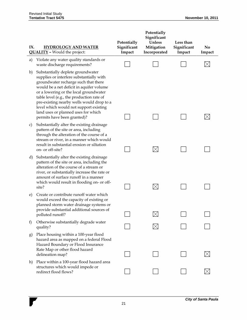
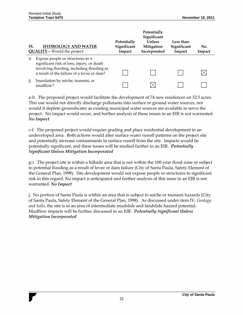
IX. HYDROLOGY AND WATER QUALITY – Would the project:
Potentially Significant
Impact
Potentially Significant
Unless Mitigation
Incorporated
Less than Significant
Impact No
Impact
a) Violate any water quality standards or waste discharge requirements?
b) Substantially deplete groundwater supplies or interfere substantially with groundwater recharge such that there would be a net deficit in aquifer volume or a lowering or the local groundwater table level (e.g., the production rate of pre-existing nearby wells would drop to a level which would not support existing land uses or planned uses for which permits have been granted)?
c) Substantially alter the existing drainage pattern of the site or area, including through the alteration of the course of a stream or river, in a manner which would result in substantial erosion or siltation on- or off-site?
d) Substantially alter the existing drainage pattern of the site or area, including the alteration of the course of a stream or river, or substantially increase the rate or amount of surface runoff in a manner which would result in flooding on- or off-site?
e) Create or contribute runoff water which would exceed the capacity of existing or planned storm water drainage systems or provide substantial additional sources of polluted runoff?
f) Otherwise substantially degrade water quality?
g) Place housing within a 100-year flood hazard area as mapped on a federal Flood Hazard Boundary or Flood Insurance Rate Map or other flood hazard delineation map?
h) Place within a 100-year flood hazard area structures which would impede or redirect flood flows?
Revised Initial Study Tentative Tract 5475 November 10, 2011
City of Santa Paula 22
IX. HYDROLOGY AND WATER QUALITY – Would the project:
Potentially Significant
Impact
Potentially Significant
Unless Mitigation
Incorporated
Less than Significant
Impact No
Impact
i) Expose people or structures to a significant risk of loss, injury, or death involving flooding, including flooding as a result of the failure of a levee or dam?
j) Inundation by seiche, tsunami, or mudflow?
a-b. The proposed project would facilitate the development of 74 new residences on 32.5 acres. This use would not directly discharge pollutants into surface or ground water sources, nor would it deplete groundwater as existing municipal water sources are available to serve the project. No impact would occur, and further analysis of these issues in an EIR is not warranted. No Impact c-f. The proposed project would require grading and place residential development in an undeveloped area. Both actions would alter surface water runoff patterns on the project site and potentially increase contaminants in surface runoff from the site. Impacts would be potentially significant, and these issues will be studied further in an EIR. Potentially Significant Unless Mitigation Incorporated g-i. The project site is within a hillside area that is not within the 100-year flood zone or subject to potential flooding as a result of levee or dam failure (City of Santa Paula, Safety Element of the General Plan, 1998). Site development would not expose people or structures to significant risk in this regard. No impact is anticipated and further analysis of this issue in an EIR is not warranted. No Impact j. No portion of Santa Paula is within an area that is subject to seiche or tsunami hazards (City of Santa Paula, Safety Element of the General Plan, 1998). As discussed under item IV, Geology and Soils, the site is in an area of intermediate mudslide and landslide hazard potential. Mudflow impacts will be further discussed in an EIR. Potentially Significant Unless Mitigation Incorporated

Revised Initial Study Tentative Tract 5475 November 10, 2011
City of Santa Paula 23
X. LAND USE AND PLANNING -- Would the proposal:
Potentially Significant
Impact
Potentially Significant
Unless Mitigation
Incorporated
Less than Significant
Impact No
Impact
a) Physically divide an established community?
b) Conflict with any applicable land use plan, policy, or regulation of an agency with jurisdiction over the project (including, but not limited to the general plan, specific plan, local coastal program, or zoning ordinance) adopted for the purpose of avoiding or mitigating an environmental effect?
c) Conflict with an applicable habitat conservation plan or natural community conservation plan?
a. The proposed project would facilitate 74 new residences on a 32.5-acre site that currently contains an abandoned avocado orchard. To the east of the southern portion of the site is an established residential neighborhood, but the proposed project is consistent with the pattern of development in the area and would not divide the community. No impact would occur and further analysis of this issue in an EIR is not warranted. No Impact b. The project site is currently outside of Santa Paula city limits but within the City’s Urban Boundary Line (CURB). The applicant is requesting annexation to the City of Santa Paula and
pre-zoning to Specific Plan-1 (SP-1). This is consistent with the current City of Santa Paula
General Plan designation for the Adams Canyon Expansion Area which allows 495 Single Family Residences and would leave 421 units still available for development. Prior to approval, the Specific Plan would be developed to be consistent with framework in the Santa Paula General Plan (1998). Section 16.01.030 of the Santa Paula Municipal Code establishes Santa Paula’s Development Code. The Code has established Hillside Grading Practices with regard to use of the natural topography, roadways and driveways (Santa Paula Municipal Code, Section 16.98). Each aspect of the proposed project regarding hillside grading and formation of roadways and driveways is expected to conform to the standards established by this Code. The site Specific Plan would need to be consistent with the General Plan, the Adams Canyon Expansion Area stipulations, and zoning standards set forth by the Specific Plan for minimum lot size, density, and other parameters. The project’s impacts would not be significant and does not warrant further discussion in an EIR. Less Than Significant Impact c. The proposed project would not conflict with an applicable habitat conservation plan or natural community conservation plan. No such plans are in place for the project site. There would be no impact and further analysis of this issue in an EIR is not warranted. No Impact

Revised Initial Study Tentative Tract 5475 November 10, 2011
City of Santa Paula 24
XI. MINERAL RESOURCES -- Would the project:
Potentially Significant
Impact
Potentially Significant
Unless Mitigation
Incorporated
Less than Significant
Impact No
Impact
a) Result in the loss of availability of a known mineral resource that would be of value to the region and the residents of the state?
b) Result in the loss of availability of a locally important mineral resource recovery site delineated on a local general plan, specific plan, or other land use plan?
a-b. The project site is within an established residential and agriculture area that is not used for mineral resource extraction. No impact would occur and further analysis of this issue in an EIR is not warranted. No Impact
XII. NOISE – Would the project result in:
Potentially Significant
Impact
Potentially Significant
Unless Mitigation
Incorporated
Less than Significant
Impact No
Impact
a) Exposure of persons to or generation of noise levels in excess of standards established in the local general plan or noise ordinance, or applicable standards of other agencies?
b) Exposure of persons to or generation of excessive groundborne vibration or groundborne noise levels?
c) A substantial permanent increase in ambient noise levels above levels existing without the project?
d) A substantial temporary or periodic increase in ambient noise levels in the project vicinity above levels existing without the project?
e) For a project located within an airport land use plan or, where such a plan has not been adopted, within two miles of a public airport or public use airport, would the project expose people residing or working in the project area to excessive noise levels?
f) For a project within the vicinity of a private airstrip, would the project expose people residing or working in the project area to excessive noise?

Revised Initial Study Tentative Tract 5475 November 10, 2011
City of Santa Paula 25
a-d. The project site neighbors a quiet residential community and an agriculture area that is currently not subject to high noise levels. However, site development could expose persons to noise in excess of standards due to temporary noise relating to construction and increases in long term noise due to project generated traffic. The proposed project would generate approximately 708 daily vehicle trips (based on a rate of 9.57 daily trips/unit – Institute of Transportation Engineers, 2003). These new trips would incrementally increase traffic noise on area roadways. Construction activity would also generate temporary increases in noise onsite and at adjacent properties. Noise levels during construction could be in the 78-88 dBA range at a distance of 50 feet during peak activity periods (U.S. Environmental Protection Agency, 1971). Such levels are substantially higher than ambient noise levels in the site vicinity and could be source of temporary noise annoyance to adjacent residents. Ambient noise levels associated with the increase of transportation and construction related activity will be further analyzed in an EIR. Potentially Significant Unless Mitigation Incorporated e,f. The project site is not within an airport land use plan, within two miles of a public airport or within the vicinity of a private airstrip. The project would not expose people residing or working in the project area to excessive noise levels. There would be no impact and further analysis of this issue in an EIR is not warranted. No Impact
XIII. POPULATION AND HOUSING — Would the project:
Potentially Significant
Impact
Potentially Significant
Unless Mitigation
Incorporated
Less than Significant
Impact
No Impact
a) Induce substantial population growth in an area, either directly (for example, by proposing new homes and businesses) or indirectly (for example, through extension of roads or other infrastructure)?
b) Displace substantial numbers of existing housing, necessitating the construction of replacement housing elsewhere?
c) Displace substantial numbers of people, necessitating the construction of replacement housing elsewhere?
a. The proposed project would add 74 residences onsite. Based on the current average household size in Santa Paula of 3.526 persons/unit (Ca. Dept. of Finance, 2010), this would generate a net population increase of about 261 people. When added to the 2010 citywide population of 30,048 (California Department of Finance, 2010), this would bring the population to 30,309. As discussed under item III, Air Quality, this is within regional population forecasts for the City. Impacts would be less than significant and further analysis in an EIR is not warranted. Less Than Significant Impact b, c. The proposed project would involve the development of a 32.5-acre parcel for a subdivision with 74 single family residences. There are no residences currently on the site. No

Revised Initial Study Tentative Tract 5475 November 10, 2011
City of Santa Paula 26
housing or people would be displaced as a result of the project; thus, there would be no impact and further analysis in an EIR is not warranted. No Impact
XIV. PUBLIC SERVICES
Potentially Significant
Impact
Potentially Significant
Unless Mitigation
Incorporated
Less than Significant
Impact No
Impact
a) Would the project result in substantial adverse physical impacts associated with the provision of new or physically altered governmental facilities, or the need for new or physically altered governmental facilities, the construction of which could cause significant environmental impacts, in order to maintain acceptable service ratios, response times or other performance objectives for any of the public services:
i) Fire protection?
ii) Police protection?
iii) Schools?
iv) Parks?
v) Other public facilities?
a (i). The Santa Paula Fire Department provides fire protection service in Santa Paula. Fire station 2, located at 536 West Main Street in Santa Paula, would serve the project site. Average response time to the project site would be 4 minutes (Santa Paula Fire Department). The proposed 74-unit increase in onsite residences would incrementally increase demand for fire protection service. However, the project site neighbors an existing residential neighborhood that is already served by the Santa Paula Fire Department and the proposed project would not require the construction of new facilities in order to maintain response time objectives. Impacts would be less than significant and further analysis of this issue in an EIR is not warranted. Less Than Significant Impact a (ii). The Santa Paula Police Department provides police protection service in Santa Paula. The Department has 34 full-time, 30 reserve officers, 12 non-sworn full-time staff, 9 non-sworn, part-time staff, and 15 volunteers. The proposed 74-unit increase in onsite residences would incrementally increase demand for police protection service. However, the project site neighbors an existing residential neighborhood that is already served by the Police Department and the proposed project would not require the construction of new facilities in order to maintain response time objectives. Impacts would be less than significant and further analysis of this issue in an EIR is not warranted. Less Than Significant Impact a (iii). The proposed project involves development of a 32.5-acre property for a 74 unit subdivision. This increase in residences may incrementally increase onsite student generation.
Revised Initial Study Tentative Tract 5475 November 10, 2011
City of Santa Paula 27
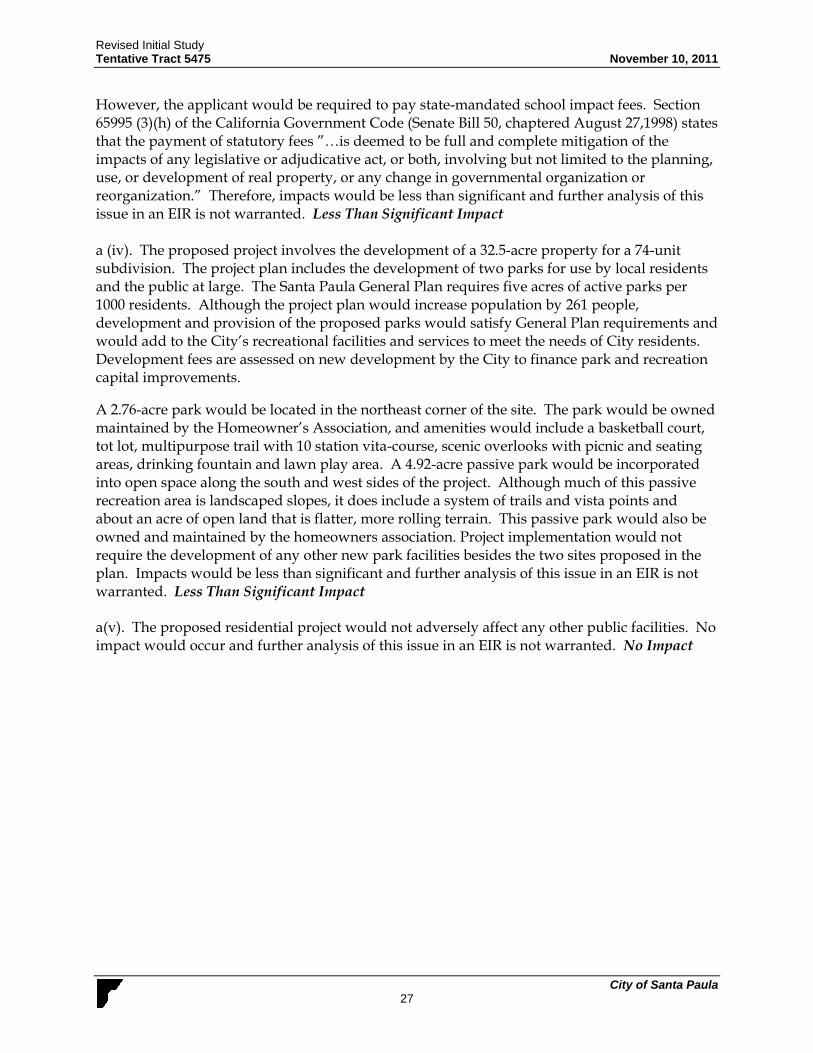
However, the applicant would be required to pay state-mandated school impact fees. Section 65995 (3)(h) of the California Government Code (Senate Bill 50, chaptered August 27,1998) states that the payment of statutory fees ”…is deemed to be full and complete mitigation of the impacts of any legislative or adjudicative act, or both, involving but not limited to the planning, use, or development of real property, or any change in governmental organization or reorganization.” Therefore, impacts would be less than significant and further analysis of this issue in an EIR is not warranted. Less Than Significant Impact a (iv). The proposed project involves the development of a 32.5-acre property for a 74-unit subdivision. The project plan includes the development of two parks for use by local residents and the public at large. The Santa Paula General Plan requires five acres of active parks per 1000 residents. Although the project plan would increase population by 261 people, development and provision of the proposed parks would satisfy General Plan requirements and would add to the City’s recreational facilities and services to meet the needs of City residents. Development fees are assessed on new development by the City to finance park and recreation capital improvements.
A 2.76-acre park would be located in the northeast corner of the site. The park would be owned maintained by the Homeowner’s Association, and amenities would include a basketball court, tot lot, multipurpose trail with 10 station vita-course, scenic overlooks with picnic and seating areas, drinking fountain and lawn play area. A 4.92-acre passive park would be incorporated into open space along the south and west sides of the project. Although much of this passive recreation area is landscaped slopes, it does include a system of trails and vista points and about an acre of open land that is flatter, more rolling terrain. This passive park would also be owned and maintained by the homeowners association. Project implementation would not require the development of any other new park facilities besides the two sites proposed in the plan. Impacts would be less than significant and further analysis of this issue in an EIR is not warranted. Less Than Significant Impact a(v). The proposed residential project would not adversely affect any other public facilities. No impact would occur and further analysis of this issue in an EIR is not warranted. No Impact

Revised Initial Study Tentative Tract 5475 November 10, 2011
City of Santa Paula 28
XV. RECREATION --
Potentially Significant
Impact
Potentially Significant
Unless Mitigation
Incorporated
Less than Significant
Impact No
Impact
a) Would the project increase the use of existing neighborhood and regional parks or other recreational facilities such that substantial physical deterioration of the facility would occur or be accelerated?
b) Does the project include recreational facilities or require the construction or expansion of recreational facilities which might have an adverse physical effect on the environment?
a. As discussed under item XIII.a(iv), the proposed project would add an estimated 261 new residents to the City. This would incrementally increase the use of existing parks. However, such an increase in use is not expected to cause any substantial deterioration of existing parks. Impacts would be less than significant and further analysis of this issue in an EIR is not warranted. Less Than Significant Impact b. The project does include the construction of two recreation facilities on the 32.5 acre site. However, development of the two parks would not have an adverse physical effect on the environment. A 2.76 acre public park would be located in the northeast corner of the site. The park amenities would include a basketball court, tot lot, multipurpose trail with 10 station vita-course, scenic overlooks with picnic and seating areas, drinking fountain and lawn play area. A 4.92 acre passive park would be incorporated into open space along the south and west sides of the project. Although much of this passive recreation area is landscaped slopes, it does include a system of trails and vista points and about an acre of open land that is flatter more rolling terrain. This passive park would be owned and maintained by the homeowners association. The park sites would actually upgrade the environmental conditions as the current state of the site is dominated by abandoned avocado trees, invasive weeds, and abandoned farm equipment. The proposed plan with incorporation of two recreation facilities would benefit the Santa Paula community aesthetically, biologically and recreationally through use of park facilities. Impacts would be less than significant and further analysis of this issue in an EIR is not warranted. Less Than Significant Impact

Revised Initial Study Tentative Tract 5475 November 10, 2011
City of Santa Paula 29
XVI. TRANSPORTATION / TRAFFIC -- Would the project:
Potentially Significant
Impact
Potentially Significant
Unless Mitigation
Incorporated
Less than Significant
Impact No
Impact
a) Cause an increase in traffic which is substantial in relation to the existing traffic load and capacity of the street system (i.e., result in a substantial increase in either the number of vehicle trips, the volume to capacity ratio on roads, or congestion at intersections)?
b) Exceed, either individually or cumulatively, a level of service standard established by the county congestion management agency for designated roads or highways?
c) Result in a change in air traffic patterns, including either an increase in traffic levels or a change in location that results in substantial safety risks?
d) Substantially increase hazards due to a design feature (e.g., sharp curves or dangerous intersections) or incompatible use (e.g., farm equipment)?
e) Result in inadequate emergency access?
f) Result in inadequate parking capacity?
g) Conflict with adopted policies, plans, or programs supporting alternative transportation (e.g., bus turnouts, bicycle racks)?
a-b. The proposed project involves development of 32.5-acre subdivision with 74 single family residences. The project would increase population by 261 people thus also increasing the number of daily trips. The Institute of Traffic Engineers has established an average rate of 9.57 daily trips/unit (Institute of Transportation Engineers, 2003). Based on the average rate, the proposed project would facilitate 708 daily trips and could increase traffic and congestion in the vicinity of the project site. In addition, the project requires a net soil export of 750,000 cy. Some or all of this export may be hauled off-site to receiver sites up to 20 miles away. Alternatively, should adequate receiver sites not be available, some of the soil may be hauled to the Toland Landfill between Santa Paula and Fillmore. The average capacity of soil haul trucks is assumed to be 13 cy, and hence up to approximately 57,692 truck trips will be required for soil export. This equates to approximately 220 truck trips per day, assuming this phase of the grading occurs over a 12-month period. Soil haul trucks and other construction-phase equipment may increase traffic and congestion in the vicinity of the site and may result in unsafe traffic conditions as equipment enters or leaves the site. These issues will be thoroughly analyzed and

Revised Initial Study Tentative Tract 5475 November 10, 2011
City of Santa Paula 30
mitigation measures will be developed for identified significant impacts within an EIR. Potentially Significant Unless Mitigation Incorporated c. The proposed residential project would not affect air traffic patterns. No impact would occur and further analysis of this issue in an EIR is not warranted. No Impact d. The proposed project does not substantially increase hazards due to a design feature or incompatible use. All new interior streets and driveways would conform to applicable requirements of the Santa Paula Municipal Code and must be approved by the City Traffic Engineer. The proposed interior streets are 36 feet wide, curb to curb, within 50 foot wide rights-of-way. Incompatible use such as farm equipment is not expected to use the planned streets. The Impacts would be less than significant and further analysis of this issue in an EIR is not warranted. Less Than Significant Impact e. Site access would be from two frontages on Foothill Road, a secondary or emergency access road from North Peck Road, and another access connection provided for the use of the property to the north. The main frontage on Foothill Road lies over 1000 feet west of Peck Rd. The other frontage is approximately 60 feet wide, located at the southwest corner of the site. It is proposed that the main frontage would be widened and improved, but that the smaller frontage, which is located between two existing uninvolved homes, would not be improved. An irrevocable offer of dedication would be made to the City so that the land would be available for widening this short frontage at a future date. Access would be adequate and plans have been reviewed by the Fire Department and the Public Works Department. Impacts would be less than significant, and further analysis of this issue in an EIR is not warranted. Less Than Significant Impact f. The proposed project involves development of 32.5-acre subdivision with 74 single family residences as well as two public parks, one of which is intended for active use. On- and off-street parking for the development would comply with the requirements of Section 16.46.100 of the Santa Paula Municipal Code that necessitate design standards for on- and off-street parking. The Municipal Code requires that residences with four bedrooms or less have at least a two car garage and homes with five or more bedrooms have at least a three car garage. Following the requirements set forth by the Municipal Code, impacts would be less than significant and further analysis of this issue in an EIR is not warranted. Less Than Significant Impact g. The proposed project involves development of 32.5-acre subdivision with 74 single family residences as well as two public parks, one of which is intended for active use. It would not conflict with adopted policies relating to alternative transportation. The General Plan designates the portion of Foothill Road along the site as a Class II Bike Lane (Santa Paula General Plan, Circulation Element, 1998). A striped bike lane to accommodate the Class II designation is included in project plans. Impacts would be less than significant and further analysis of this issue in an EIR is not warranted. Less Than Significant Impact
Revised Initial Study Tentative Tract 5475 November 10, 2011
City of Santa Paula 31
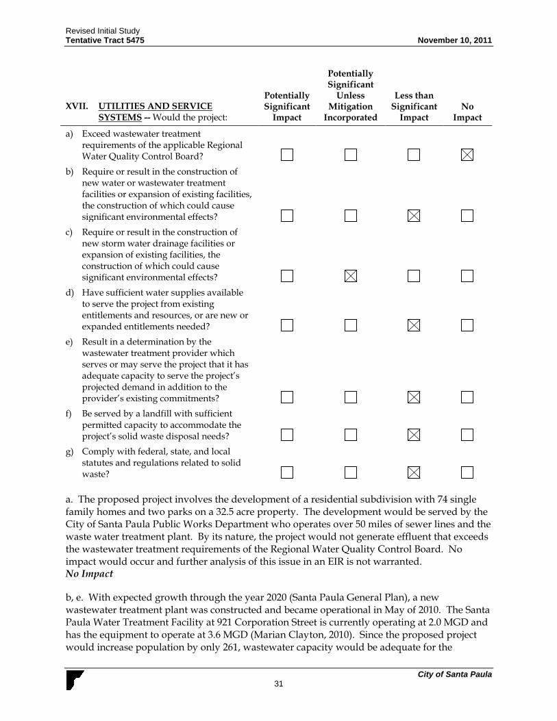
XVII. UTILITIES AND SERVICE SYSTEMS -- Would the project:
Potentially Significant
Impact
Potentially Significant
Unless Mitigation
Incorporated
Less than Significant
Impact No
Impact
a) Exceed wastewater treatment requirements of the applicable Regional Water Quality Control Board?
b) Require or result in the construction of new water or wastewater treatment facilities or expansion of existing facilities, the construction of which could cause significant environmental effects?
c) Require or result in the construction of new storm water drainage facilities or expansion of existing facilities, the construction of which could cause significant environmental effects?
d) Have sufficient water supplies available to serve the project from existing entitlements and resources, or are new or expanded entitlements needed?
e) Result in a determination by the wastewater treatment provider which serves or may serve the project that it has adequate capacity to serve the project’s projected demand in addition to the provider’s existing commitments?
f) Be served by a landfill with sufficient permitted capacity to accommodate the project’s solid waste disposal needs?
g) Comply with federal, state, and local statutes and regulations related to solid waste?
a. The proposed project involves the development of a residential subdivision with 74 single family homes and two parks on a 32.5 acre property. The development would be served by the City of Santa Paula Public Works Department who operates over 50 miles of sewer lines and the waste water treatment plant. By its nature, the project would not generate effluent that exceeds the wastewater treatment requirements of the Regional Water Quality Control Board. No impact would occur and further analysis of this issue in an EIR is not warranted. No Impact
b, e. With expected growth through the year 2020 (Santa Paula General Plan), a new wastewater treatment plant was constructed and became operational in May of 2010. The Santa Paula Water Treatment Facility at 921 Corporation Street is currently operating at 2.0 MGD and has the equipment to operate at 3.6 MGD (Marian Clayton, 2010). Since the proposed project would increase population by only 261, wastewater capacity would be adequate for the

Revised Initial Study Tentative Tract 5475 November 10, 2011
City of Santa Paula 32
proposed project. Impacts would be less than significant and further analysis of this issue in an EIR is not warranted. Less Than Significant Impact
c. As discussed under item IX, Hydrology and Water Quality, the proposed project alters storm water flow patterns on the project site. This could potentially adversely affect the local storm drain system. Impacts would be potentially significant and this issue will be further discussed pursuant in an EIR. Potentially Significant Unless Mitigation Incorporated
d. The project site would receive water service from the City of Santa Paula. The City’s drinking water supply is provided by groundwater pumped from the Santa Paula basin. The basin is made up of hundreds of feet of sands and gravels deposited in the Santa Clara Valley and the mouth of the Santa Paula Canyon, which contains millions of gallons of water between the sand and gravel particles. With the five City owned deep wells, the water system can produce up to 10.6 million gallons per day (City of Santa Paula, 2007). Santa Paula residents average 132 gallons of water per day (Santa Paula Public Works Department). The level of demand generated by the proposed project (34,452 gallons per day for 261 people) would impact existing and planned water supplies. The applicant does own three memberships to agricultural water rights owned by Thermal Belt Mutual Water Company. However, these rights are not transferable to the City of Santa Paula. The City requires all new development to pay their share of the development impact fees (personal communication, Jon Turner, Deputy Public Works Director, July 2007). As a result, the applicant would pay fees to the City of Santa Paula to compensate for the increased water demand. Compliance with the City policy would reduce impact to a less than significant level. Less Than Significant Impact
f, g. The City of Santa Paula provides refuse collection and disposal service by contracting with a private hauler: Crown Disposal. The City trash collection is approximately 8,560 tons of solid waste per year. Crown Disposal disposes Santa Paula’s waste at the Toland Landfill which lies between Santa Paula and Fillmore. Toland has a daily maximum capacity of 1,500 tons per day and currently averages approximately 1,300 tons pre day (City of Santa Paula Public Works Department). All of Crown Disposal’s mixed commercial trash is brought to Community Recycling Material Recovery Facility in Sun Valley, where it is preprocessed to extract recyclables before delivering remaining residue to a landfill. Data generated from the California Integrated Waste Management Board and presented in a 2005 annual report, states that each Santa Paula citizen generates an average of two pounds of trash per day (2005 Santa Paula CIWMB report). The proposed project would generate an estimated 261 new residents (74 new residences at 3.526 people/residence, CA. Dept. of Finance, 2007). This increase would represent less than 1% of the available daily capacity at Toland Landfill. Therefore, impacts to area landfills would be less than significant and further analysis of this issue in an EIR is not warranted. Less Than Significant Impact.

Revised Initial Study Tentative Tract 5475 November 10, 2011
City of Santa Paula 33
XVIII. MANDATORY FINDINGS OF SIGNIFICANCE —
Potentially Significant
Impact
Potentially Significant
Unless Mitigation
Incorporated
Less than Significant
Impact No
Impact
a) Does the project have the potential to substantially reduce the habitat of a fish or wildlife species, cause a fish or wildlife population to drop below self- sustaining levels, eliminate a plant or animal community, reduce the number or restrict the range of a rare or endangered plant or animal or eliminate important examples of the major periods of California history or prehistory?
b) Does the project have impacts that are individually limited, but cumulatively considerable? (“Cumulatively considerable” means that the incremental effects of a project are considerable when viewed in connection with the effects of past projects, the effects of other current projects, and the effects of probable future projects)?
c) Does the project have environmental effects which will cause substantial adverse effects on human beings, either directly or indirectly?
a. The proposed project would have the potential to adversely affect onsite biological resources. Although cultural resources are not known to be present onsite, site development could potentially disturb as yet undiscovered resources. Impacts would be potentially significant and biological and cultural resource impacts will be further studied in an EIR. Potentially Significant Unless Mitigation Incorporated b. The proposed project would develop a 32.5 acre site for a residential subdivision with 74 single family homes . The project would intensify the use of the 32.5-acre site. Such intensification is consistent with ongoing land use patterns in the area as well as the City’s development standards. Nevertheless, certain cumulative impacts may be potentially significant unless mitigation is incorporated for the issues to be studied in an EIR (aesthetics, air quality, biological resources, cultural resources, geology and soils, greenhouse gas emissions, hazards and hazardous materials, hydrology and water quality, noise, and transportation and circulation). The EIR will discuss potential cumulative impacts relating to these issues. Potentially Significant Unless Mitigation Incorporated c. The proposed project is consistent with the surrounding land use as a residential neighborhood. By its nature, the project would not adversely affect human beings. No impact is anticipated and further analysis of this issue in an EIR is not warranted. No Impact

Revised Initial Study Tentative Tract 5475 November 10, 2011
City of Santa Paula 34
REFERENCES California Department of Conservation, State of California Earthquake Fault Zones Official
Map: Santa Paula Quadrangle (Figure 4d), May 1, 1999.
California Department of Conservation, Division of Land Resource Protection, Farmland Mapping and Monitoring Program, 2002.
California Environmental Protection Agency-Cortese List Data Sources. (http://www.calepa.ca.gov/SiteCleanup/CorteseList/default.htm).
California Integrated Waste Management Board (CIWMB). “Active Landfills Profile for Chiquita Canyon Landfill.” (http://www.ciwmb.ca.gov/Profiles/Facility/Landfill/ LFProfile1.asp?COID=42&FACID=56-AA-0005).
California Integrated Waste Management Board (CIWMB) – Santa Paula Annual Report (2005).
Santa Paula, City of, General Plan. (http://www.ci.santa-paula.ca.us/planning/GeneralPlan.htm)
Santa Paula, City of, Municipal Code. http://amlegal.com/nxt/gateway.dll/California/santapa/titlexvidevelopmentcode/ chapter1642performancestandards?f=templates$fn=altmain-nf.htm$3.0#JD_16.42.050
Environmental Protection Agency. Water Sense. http://www.epa.gov/watersense/water/text.htm
Institute of Transportation Engineers, Trip Generation, 7th Edition, 2003.
Santa Paula Fire Code Enforcement. 200 S. 10th St., Santa Paula, Ca 93060 (805) 933-4265
Santa Paula Public Works Department.
Southern California Association of Governments, City Projections, 2004. www.scag.ca.gov/forecast/index.htm
State of California, Department of Finance, E-5 Population and Housing Estimates for Cities, Counties and the State, 2001-2010, with 2000 Benchmark. May 2010. http://www.dof.ca.gov/research/demographic/reports/estimates/e-5/2001-10/view.php
State of California Seismic Hazard Zones: Santa Paula Quadrangle Official Map. Prepared June 21, 2002. (http://gmw.consrv.ca.gov/shmp/download/pdf/ozn_spaul.pdf).
U.S. Environmental Protection Agency, Noise from Construction Equipment and Operations, PB 206 717, 1971.
U.S Census Bureau: State & County Quickfacts – Santa Paula, Ventura County, California.
Ventura County Air Quality Guidelines. http://www.vcapcd.org/environmental_review.htm.
Wastewater Discharge Requirements for the City of Santa Paula. State of California. California
Regional Water Quality Control Board. http://www.swrcb.ca.gov.

Revised Initial Study Tentative Tract 5475 November 10, 2011
City of Santa Paula 35
Personal Communication: Marian Clayton, Marketing Director, Perc Water. Telephone conversation, December 20, 2010.

Revised Initial Study Tentative Tract 5475 November 10, 2011
City of Santa Paula 36
This page intentionally left blank.