Embed Size (px)
Citation preview

REVISION
GRADE 11

GLOBAL AIR CIRCULATION

DIFFERENCE BETWEEN HIGH AND LOW PRESSURE:
LOW PRESSURE:
• Air rises in the middle;
• Air move clockwise in southern hemisphere;
• Unstable conditions with clouds and rain;
• Isobars decrease towards the middle


HIGH PRESSURE:
•Air descends in the middle;
•Air move anticlockwise in southern
hemisphere;
•Stable conditions with clear skies and
sunshine;
• Isobars increase towards the middle.


FOUR GLOBAL PRESSURE BELTS:

EQUATORIAL LOW PRESSURE
ZONE:
• 5° N and S
• High amount of isolation leads to warm air rising.
• Rising moist air cause cloud formation and high
rainfall.

SUBTROPICAL HIGH PRESSURE
ZONE:
•30° - 40° N and S
•Air cools down and descend (sink);
•Descending air is warm and dry and leads
to the formation of deserts;
•Cause warm days and low rainfall.

SUBPOLAR LOW PRESSURE ZONE:
•60° N and S
•Different air masses meet;
•Ascending (rising) air due to
convection. Warm air is forced to rise.
•Low pressure cell is formed;

POLAR HIGH PRESSURE ZONE:
•90° N and S
•Caused by cold and dense sinking air;
•Stable, clear and cold conditions.

TRI-CELLULAR CIRCULATION:
Ensure that no surplus energy is stored at the
equator.
THREE CELLS:
1. Hadley cell: 0° - 30 ° N and S
2. Ferrel cell: 30 ° - 60 ° N and S
3. Polar cell: 60 ° - 90 ° N and S
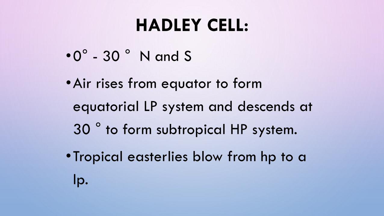
HADLEY CELL:
•0° - 30 ° N and S
•Air rises from equator to form
equatorial LP system and descends at
30 ° to form subtropical HP system.
•Tropical easterlies blow from hp to a
lp.

•Forms of ITCZ at equator (area of
convergence of tropical easterlies)
•Forms large cumulonimbus clouds
where ITCZ form.
•Cause heavy rain and thunderstorms.
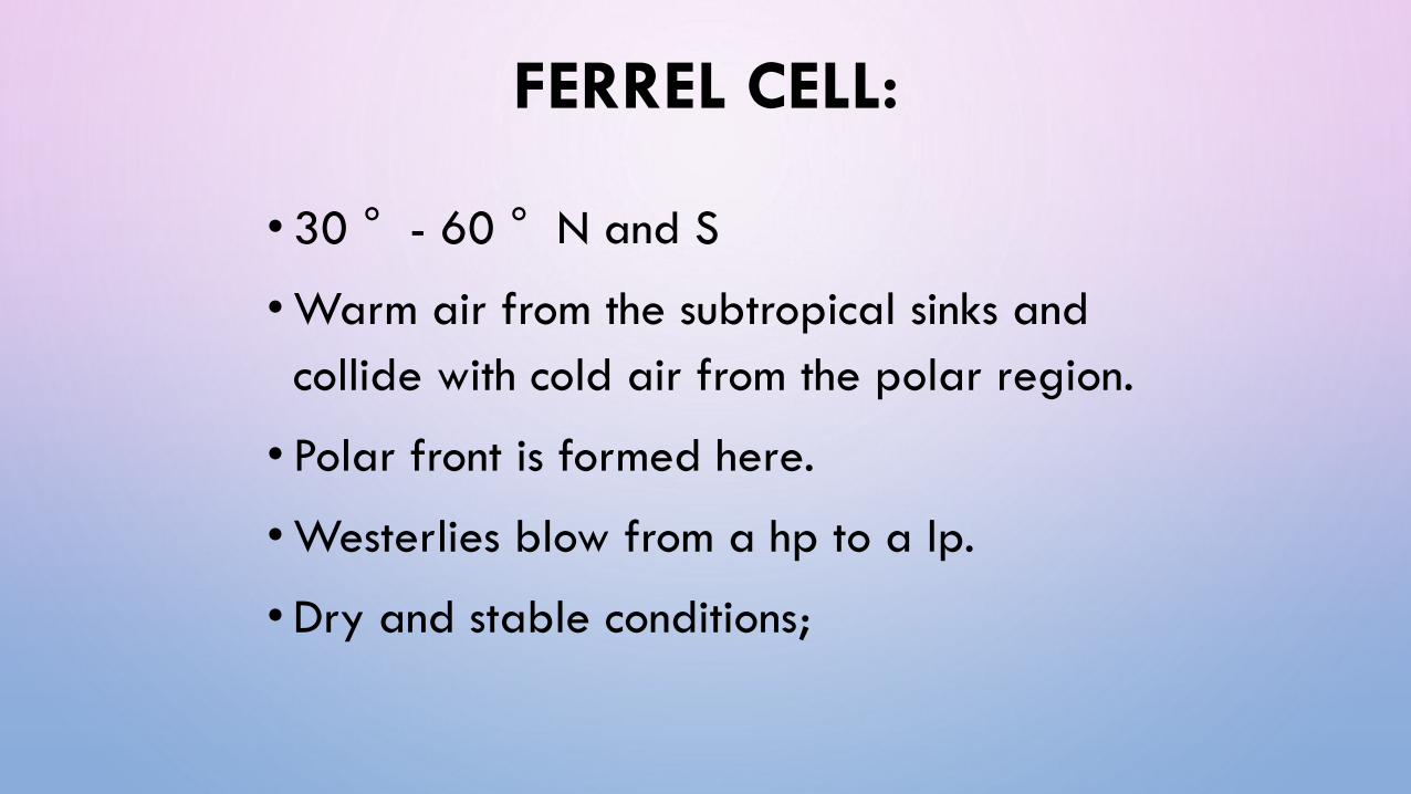
FERREL CELL:
• 30 ° - 60 ° N and S
•Warm air from the subtropical sinks and
collide with cold air from the polar region.
• Polar front is formed here.
•Westerlies blow from a hp to a lp.
•Dry and stable conditions;

POLAR CELL:
• 60 ° - 90 ° N and S
• Air from the 90° sinks at form the HP cell.
• Polar easterlies blow from a hp system to a
lp system.
•Mid latitude cyclones form at the polar
front.

WARM LIGHTER AIR IS
FORCED TO RISE
FERREL CELL
POLAR CELL
Cold dense air
force warm air
to rise

CORIOLIS FORCE
•As air move from a high pressure to a low
pressure it is deflected and change direction.
•Reason: rotation of the earth.
•The winds deflect from north to south.
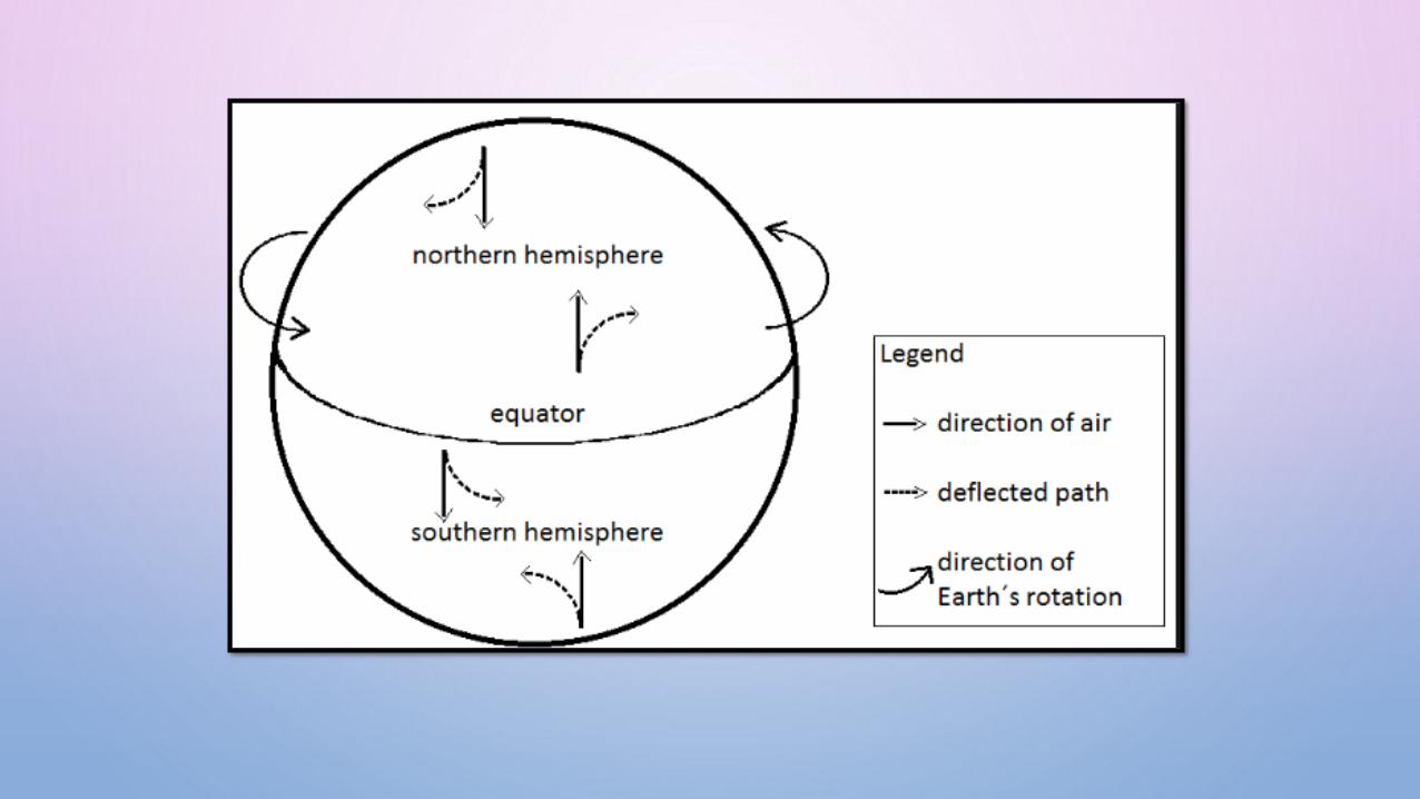

FERREL’S LAW
•Air is deflected to the LEFT in the southern
hemisphere and to the RIGHT in the northern
hemisphere

GEOSTROPHIC FLOW:
• Wind that blow parallel to isobars;
• Wind move from a high pressure to a low
pressure;
• Coriolis effect cause winds to deflect.
• When Coriolis force and pressure gradient is
equal and in opposite effect it will blow parallel
to the isobars.


WINDS RELATED TO GLOBAL AIR CIRCULATION:
TROPICAL EASTERLIES WESTERLIES POLAR EASTERLIES
Between 5° and
30/40° N and S.
Between 40° - 60° N
and S.
Move from poles to
60° N and S.
Move from Subtropical
HP to Equatorial LP.
Move from
Subtropical HP to
Subpolar LP.
Move from Polar HP
to Subpolar LP
Migrate North and
South as the ITCZ move
with season.
Winds gather latent
heat and is warm and
moist.
Very cold winds.

AIR MASS CHARACTERISTICS:
1. Air can heat up and cool down.
2. Air can shrink or expand.
3. Air has a mass. Air can be heavy or light.
4. Air can move vertically and horizontally.

SYNOPTIC WEATHER MAPS:
Definition: Map that shows a range of weather conditions for a particular area on a particular day.
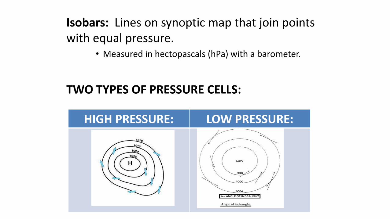
Isobars: Lines on synoptic map that join points with equal pressure.
• Measured in hectopascals (hPa) with a barometer.
TWO TYPES OF PRESSURE CELLS:
HIGH PRESSURE: LOW PRESSURE:

HIGH PRESSURE CELL:
- Pressure increase towards the middle.
- Warm, stable and sunny conditions.
LOW PRESSURE CELL:
- Pressure decrease towards the middle.
- Rainy, unstable and cloudy conditions.

WEATHER ELEMENTS ON SYNOPTIC MAPS:
Air temperature
Dew point temperature
Type of precipitation
Cloud cover
Wind direction
Wind speed

TYPES OF PRECIPITATION:

CLOUD COVER:

WIND SPEED:

TYPES OF FRONTS:
COLD FRONT: WARM FRONT:Leads with warm air and brings
cold air behind.Leads with cold air and brings
warm air behind.
In front: Warm air In front: Cold air
Behind: Cold air Behind: Warm air
Impact on weather: Bring cold weather to South Africa.
Impact on weather: Little to noeffect on climate.

WINTER SYNOPTIC MAP:

FEATURE OF A WINTER MAP:• The date on the map;
• High pressure cell over the interior of South Africa;
• Other high pressure cells are closer to land and more North;
• Low temperatures over the land;
• Cold fronts are present.

SUMMER SYNOPTIC MAP:
FEATURE OF A SUMMER MAP:• The date on the map;
• Low pressure cell over the interior of South Africa;
• High temperatures over the land;
• Occlusion of cold and warm front are present (Tropical cyclone).


![Revision 1 - Health Sciences Authority · REVISION HISTORY Guidance Version (Publish Date) [3 latest revisions] Revision GN -33: Revision 1 (October 2017 ) R1 R1.1 GN-33: Revision](https://img.pdfslide.net/doc/110x75/5f68252834c0024cc457a63d/revision-1-health-sciences-authority-revision-history-guidance-version-publish.jpg)