Embed Size (px)
Citation preview

Revision of Middle Proterozic YellowjacketFormation, Central Idaho, andRevision of Cretaceous Slim Sam Formation,Elkhorn Mountains Area, Montana
U.S. Department of the InteriorU.S. Geological Survey
U.S. Geological Survey Professional Paper 1601

Revision of Middle Proterozoic Yellowjacket Formation, Central Idaho, andRevision of Cretaceous Slim Sam Formation,Elkhorn Mountains Area, Montana
By
R.G. Tysdal
A. Revision of Middle Proterozoic Yellowjacket Formation, Central Idaho
By
R.G. Tysdal
B. Revision of Cretaceous Slim Sam Formation, Elkhorn Mountains Area, Montana
By
R.G. Tysdal
U.S. Geological Survey Professional Paper 1601–A–B
Chapters A and B are issued as a single volumeand are not available separately
U.S. Department of the InteriorU.S. Geological Survey

Revision of Middle Proterozoic Yellowjacket Formation,Central Idaho
By
R.G. Tysdal
Revision of Middle Proterozoic Yellowjacket Formation, Central Idaho, and Revision ofCretaceous Slim Sam Formation, Elkhorn Mountains Area, Montana
U.S. Geological Survey Professional Paper 1601–A
U.S. Department of the InteriorU.S. Geological Survey

Tysdal, Russell G.Revision of Middle Proterozoic Yellowjacket Formation, central Idaho, and revision
of Cretaceous Slim Sam Formation, Elkhorn Mountains area, Montana / by R.G. Tysdal.p. cm. — (U.S. Geological Survey professional paper ; 1601 A-B)
“Chapters A and B are issued as a single volume and are not available separately.”Includes bibliographical references.Supt. of Docs. no.: I 19.16:1601 A-B1. Geology, Stratigraphic—Proterozoic. 2. Geology—Idaho—Yellowjacket
Formation. 3. Yellowjacket Formation (Idaho) 4. Geology, Stratigraphic—Cretaceous. 5. Geology—Montana—Slim Sam Formation. 6. Slim Sam Forma-tion (Mont.) I. Title. II. Series.QE653.5.T968 1999 98–18450551.7
′
15
′
09796—dc21 CIP
U.S. Department of the Interior
Bruce Babbitt, Secretary
U.S. Geological Survey
Charles G. Groat, Director
For sale by U.S. Geological Survey, Information ServicesBox 25286, Federal CenterDenver, CO 80225
This publication is also available online at:
http://greenwood.cr.usgs.gov/pub/ppapers/p1601/
Any use of trade, product, or firm names in this publicationis for descriptive purposes only anddoes not imply endorsement by the U.S. Government
Library of Congress Cataloging-in-Publication Data
First printing December 2000

AI
Contents
Table
1. Correlation diagram for Middle Proterozoic rocks of east-central Idaho
Figures
1. Index map of east-central Idaho
2. Geologic map of contiguous areas in western part of Lemhi Range andsouthern part of Salmon River Mountains
..............................................................................
A3
...................................................................
5
Abstract .......................................................................................................................................... A1Introduction.................................................................................................................................... 1Stratigraphic Units ........................................................................................................................ 4
Yellowjacket–Quartzite Mountain–Iron Lake Area of Salmon River Mountains....... 4Yellowjacket Formation (Restricted)........................................................................ 4Hoodoo Quartzite......................................................................................................... 6Unnamed Argillaceous Quartzite.............................................................................. 6
Western Part of Lemhi Range ............................................................................................ 6Big Creek Formation ................................................................................................... 6Apple Creek Formation............................................................................................... 7
Fine Siltite Unit .................................................................................................... 7Diamictite Unit .................................................................................................... 7Coarse Siltite Unit............................................................................................... 7
Gunsight Formation..................................................................................................... 7Swauger Formation..................................................................................................... 7
Structural and Stratigraphic Patterns ....................................................................................... 8Regional Patterns................................................................................................................. 8Iron Lake Fault ...................................................................................................................... 8
Previous Stratigraphic Interpretations...................................................................................... 9Age of the Yellowjacket Formation (Restricted) ...................................................................... 11Application to Stratabound Mineralization............................................................................... 11Conclusions .................................................................................................................................... 11References Cited........................................................................................................................... 12Addendum
.......................................................................................................................
13
................
A2

A1
Revision of Middle Proterozoic Yellowjacket Formation, Central Idaho
By
R.G. Tysdal
Abstract
The Proterozoic Yellowjacket Formation is restricted to the strata originally assigned to it by Ross (1934). The Yellowjacket is conformable beneath the Hoodoo Quartzite, which in turn is conformable beneath an unnamed argillaceous quartzite unit. The three units constitute a genetically related sequence of strata that lies in a structural block delimited on the northeast by the Iron Lake fault. This fault and the strata northeast of it are trun-cated on the west by the younger Quartzite Mountain fault. Directly northeast of the Iron Lake fault, strata currently assigned by others to the lower subunit of the Yellowjacket are correlated with the Apple Creek Formation in the northern part of the Lemhi Range. The Yellowjacket name should not be applied to the lower subunit or to strata that lie above it.
Mapping in the western part of the Lemhi Range shows that the Apple Creek Formation lies depositionally above the Big Creek Formation and that no rocks of the Yellowjacket-Hoo-doo-unnamed unit stratigraphic sequence are present. In con-trast, in the area of the Yellowjacket mapped by Ross (1934) and the area directly northeast of the Iron Lake fault, the Big Creek Formation is absent, even though it is 2,700 m thick in the Lemhi Range. A small sliver of the Big Creek is present in the southeastern part of the Salmon River Mountains, however. These data indicate that the Iron Lake fault juxtaposed the Yel-lowjacket-Hoodoo-unnamed unit stratigraphic sequence against non-Yellowjacket strata to the northeast.
Introduction
This report builds on recent geologic mapping, strati-graphic, and sedimentologic studies in the northern part of the Lemhi Range. Its goal is to correlate Middle Proterozoic strata in the Lemhi Range with strata in the Salmon River Mountains and reconcile differences of interpretation and nomenclature. The initial correlation of the Proterozoic strata in these two ranges was made by Ruppel (1975) in conjunction with his map-ping in the central part of the Lemhi Range. Ruppel (1975) set the stage for subsequent workers on Proterozoic stratigraphy in central Idaho by determining the stratigraphic succession during the course of his geologic mapping (Ruppel, 1968, 1980; Ruppel and Lopez, 1981). Although Ruppel conducted no detailed map-ping in the northern part of the Lemhi Range, he (Ruppel, 1975, p. 5–6) interpreted strata there to be older than Proterozoic rocks to the south and to be the lowest Precambrian rocks exposed in central Idaho, which “...are here correlated on the basis of
lithologic similarity with the Yellowjacket Formation of central Idaho as defined by Ross (1934, p. 16).” Subsequent mapping by Tysdal (1996a, 1996b) and Tysdal and Moye (1996) showed that the Proterozoic strata in the northern part of the Lemhi Range are contiguous with strata in the central part, comprised of the Lemhi Group (in ascending order, Inyo Creek, West Fork, Big Creek, Apple Creek, and Gunsight Formations) and the overlying Swauger Formation (table 1). Connor (1990a, 1991) previously had correlated some of these same strata in the north-ern part of the Lemhi Range with rocks in the Salmon River Mountains that he considered to be Yellowjacket Formation. This report discusses stratigraphic and structural data in the area in which the Yellowjacket was originally named by Ross (1934), bringing new geologic mapping and sedimentologic data into consideration to reinterpret application of the name Yellow-jacket Formation and to refine stratigraphic correlations.
The Yellowjacket Formation was named by Ross (1934) for a sequence of clastic rocks present in the vicinity of the Yellow-jacket mine and the townsite of the same name in the Salmon River Mountains of central Idaho (fig. 1). No strata are exposed beneath the Yellowjacket Formation, but it is overlain by the Hoodoo Quartzite, also named by Ross (1934), and is discussed herein because its history is directly related to that of the Yel-lowjacket.
Ross (1934) mapped about 50 km
2
of Yellowjacket and Hoodoo strata south of lat 45
°
N. in the vicinity of the townsite of Yellowjacket (fig. 1). His description of the two units was based on a section measured for “about 4.5 mi [7 km] along the road up Yellowjacket Creek” (Ross, 1934, p. 15), starting from the processing mill for the Yellowjacket mine, which is at the edge of the townsite of Yellowjacket (fig. 2). The route included about 2.5 km of traverse within his map area and extended about 5 km beyond, to the northeast. No type section or locality was formalized for either formation,
1
but Ekren (1988) designated the measured section of Ross (1934) as the principal reference section for both formations.
The upper contact of the Yellowjacket is transitional into the Hoodoo in the general area, but was reported to be a thrust fault in some places (Ross, 1934). Ekren (1988) concluded this contact is depositional except where the two formations are jux-taposed along high-angle faults, one of which is at the base of steeply dipping beds of Hoodoo in the measured section of Ross (1934). The high-angle faults display a component of lateral slip (Ekren, 1988).
1
Naming of the Yellowjacket Formation preceded the necessity of designation of a type section according to the guidelines of the North American Stratigraphic Code (North American Commission on Stratigraphic Nomenclature, 1983).

A2
Revision of Middle Proterozoic Yellow
jacket Formation and Cretaceous Slim
Sam Form
ation
Table 1.
Correlation diagram for Middle Proterozoic rocks of east-central Idaho.
[Diagram is separated into upper and lower parts. Some workers interpreted the Yellowjacket Formation to underlie the Lemhi Group and superjacent strata; other workers considered the typeYellowjacket (of Ross, 1934) (leftmost column) to be separated by a fault from other rocks. I interpret the type Yellowjacket, Hoodoo, and unnamed overlying unit to be part of a structural block juxtaposed against the Lemhi Group and superjacent rocks. Upper part of diagram shows lateral correlation of rock units. Lower part of diagram shows lateral correlation of only the three units of Ross (1934); the other units of the lower part are a mix of units of Ross (1934) and units of the Lemhi Group and superjacent strata, as explained in the text. Dark shading indicates Yellowjacket Formation as defined and mapped by Ross (1934) and rock units of subsequent workers that I interpret to be the same formation. Light shading indicates Apple Creek Formation as defined and mapped by Anderson (1961) and rock units of subsequent workers that I interpret to be the same formation. Interpretation is necessary because maps of authors locally or regionally include rocks that I believe are of formations other than those to which they were assigned due to unrecognized faults, contacts, misinterpretation of contrasting depositional environments, or names introduced subsequent to an author's mapping. No thickness of formations is implied. “Height” of boxes is greater for some units to accommodate different nomenclatures and (or) sub-divisions of formations]
Ross (1947),upper column.
Ross (1934),lower column. Ruppel (1975) Lopez (1981)
Ruppel andLopez (1988) Bennett (1977)
Connor andEvans (1986);Connor (1990A);Evans andConnor (1993);Evans (1999) Ekren (1988)
Winston and Link 1993)
Tysdal and Moye(1996), Tysdal(1996a, b, 2000) andTHIS REPORT
Tietbohl (1981,1986)
Anderson (1961)
Lawson Creek Fm Lawson Creek Fm Lawson Creek Fm
Swauger Fm Swauger Fm Swauger Fm Swauger Fm Swauger Fm Swauger Fm Swauger Fm
Gunsight Fm Gunsight Fm Yellow- Mem E Gunsight Fm Lemhi Quartzite
Apple AppleMem B, C, D Apple
c. siltite
Apple Creek Fm
Lemhi Creek Creek jacketCreek
diamictite
diamictite
Fm FmFm Fm
f.
siltite
Big
Big Big Big Creek
Creek Fm Creek Fm Hoodoo Quartzite Creek Fm Big Creek Fm Fm
West Fork Fm West Fork Fm West Fork Fm West Fork Fm
Inyo Creek Fm Inyo Creek Fm Inyo Creek Fm Inyo Creek Fm
FAULT
Unnamed unit Unnamed unit Unnamed unit
Hoodoo Quartzite
THRUST FAULT FAULT THRUST FAULT
Hoodoo Quartzite Hoodoo Quartzite
Yellowjacket Fm Yellow-Yellow-
Mem EYellow-
Mem E Yellowjacket Yellow- U Yellowjacket Fm Yellowjacket Fm
Mem D Mem D Fm Phylite L M
jacket jacket Mem C jacket Mem C jacket L
Mem B Mem B L
Fm Fm Mem A Fm Mem A Fm L
Quartzite
Yellow-Yellow-
Apple
Creek Fm
HoodooQuartzite

Revision of Middle Proterozoic Yellowjacket Formation, Central Idaho A3
Yellowjacket
Challis
Salmon
Leadore
Area mapped by Ross (1934) (part)
QuartziteMountain
114°30'
0 10 20 MILES
0 10 20 30 KILOMETERS
IDAHO
BLACKBIRDMINE
YELLOW-JACKET
MINE
IronLake
CLEARWATER MOUNTAINS
MONTANA
IDAHO
BEAVERH
EAD
MO
UN
TAIN
S
LEMH
I
RANGE
LOS
T RIVER
RANG
E
SALM
ON
MO
UN
TAIN
S
RIV
ER
Lemhi
River
Hay
den
Creek
Pahsimeroi
River
Salm
on
Riv
er
Moyer
Creek
Iron Creek
N. F
k Ir
on C
r
Hat Creek Porphyry Cr
Musgrove Cr
Yellowjac
ket
Creek
Shov
el C
r
Lake Cr Hoo
doo
Cr
Panther
Creek
Mid
dle
Fork
Sal
mon
Riv
er
Salmon River
93�
93�
114° 113°30'
45°30'
45°
44°30'
Area of figure
28
N. Fk
HatCr
Figure 1.
Index map of east-central Idaho, showing major geographic features. Shading indicates mountain ranges.
The upper contact of the Hoodoo along the measured sec-tion was found to be gradational into a unit of banded, slightly calcareous quartzite. The quartzite unit is not present in the 50 km
2
area mapped by Ross, although present north of his map area, and was not assigned a formal name; Ekren (1988) did not
apply a formal name to the unit either. The conformable succes-sion of the Yellowjacket of Ross (1934), Hoodoo Quartzite, and the overlying unnamed unit constitute a genetically related sequence of strata mainly deposited in shallow subtidal, inter-tidal, and perhaps supratidal environments.

A4 Revision of Middle Proterozoic Yellowjacket Formation and Cretaceous Slim Sam Formation
North and east of the area of Ross’ (1934) work, several authors (Vhay, 1948; Bennett, 1977; Hughes, 1983; Hahn and Hughes, 1984; Lopez, 1981; Connor and Evans, 1986; Ekren, 1988; Fisher and others, 1992; Evans and Connor, 1993; and Evans, 1999) applied the Yellowjacket name to strata in an extensive area of the Salmon River Mountains (table 1). Appli-cation of the Yellowjacket name in this extensive area is called into question for the following reasons: (1) The stratigraphic sequence of the Yellowjacket, Hoodoo, and overlying unnamed unit lies in a structural block (sheet?) delimited on the northeast by the Iron Lake fault and on the west by the Quartzite Mountain fault (fig. 2). (2) Rocks of the stratigraphic sequence were depos-ited in shallow subtidal to upper intertidal environments in con-trast with deeper water turbidite strata directly north and east of the faults and in contrast with the turbidites that constitute some of the rocks described by Lopez (1981), Sobel (1982), Hughes (1983), and Hahn and Hughes (1984) and assigned to the Yel-lowjacket in the general area that includes the Blackbird mine and the North Fork of Iron Creek (figs. 1, 2). (3) North of the Iron Lake fault and east of the Quartzite Mountain fault, the lower subunit of the Yellowjacket, as used by Connor and Evans (1986), Connor (1990a), and Evans and Connor (1993), is corre-latable with the Apple Creek Formation (named by Anderson, 1961) in the northern part of the Lemhi Range (Connor, 1990a, 1991). Mapping in the Lemhi Range (Tysdal, 1996a, 1996b, in press; Tysdal and Moye, 1996) revealed that the Apple Creek lies depositionally above the Big Creek Formation (named by Rup-pel, 1975) and that no “type” Yellowjacket, Hoodoo, or unnamed post-Hoodoo strata are present. The Big Creek, about 2,700 m thick in the Lemhi Range, is absent from the area of the Yellow-jacket as mapped by Ross (1934) and from the area directly north of the Iron Lake fault near its junction with the Quartzite Mountain fault. Two slivers of the Big Creek are present in the southeastern part of the Salmon River Mountains, one of which is in fault contact with the Swauger Formation (fig. 2, long 114
°
W., near Lem Peak fault).The purpose of this paper is to restrict the Yellowjacket
name to the strata beneath the Hoodoo Quartzite, as the name was applied originally by Ross (1934). Strata directly above the Hoodoo remain unnamed. The most recent maps of the extensive area of the Salmon River Mountains directly north of the Iron Lake fault are those of Connor and Evans (1986), Connor (1990a, 1991), and Evans and Connor (1993). These maps were completed prior to mapping and other studies in the northern part of the Lemhi Range (Tysdal, 1996a, 1996b, 1996c, in press) that permit correlation and reconciliation of strata in the two mountain ranges. The nomenclatural changes advocated here reflect this more recent work. Strata mapped and assigned to the lower subunit of the Yellowjacket by Connor and Evans on their maps here are reassigned to the Apple Creek Formation, with which they are contiguous (table 1), as Connor (1990a, 1991) recognized. No correlation of the post-Apple Creek strata previ-ously assigned to the Yellowjacket Formation is undertaken here, and the middle and upper units of the Yellowjacket, as the name is used by Connor and Evans in their papers, are not renamed. The Yellowjacket name should not be applied to them, however, because the mapping and other work of Connor and Evans deter-mined that these strata constitute a conformable sequence above their lower subunit of the Yellowjacket.
The change in status of the name Yellowjacket Formation advocated in this report restricts the name to the strata to which it was applied originally by Ross (1934). An alternative is to raise the name Yellowjacket to Supergroup status, thus including all of the rocks to which the Yellowjacket name is now applied, and including the Lemhi Group as a subdivision. This latter approach has merit because the Yellowjacket name has been applied to virtually all of the strata within the Salmon River Mountains, including correlatives of units of the Lemhi Group that lie within the Salmon River Mountains and some units within the Lemhi Range and Beaverhead Mountains as well. However, this approach still requires that a new name be applied to each mappable unit that presently has Yellowjacket in its name (for example, lower subunit of Yellowjacket Formation). Furthermore, a new name would have to be applied to strata of the Yellowjacket Formation as originally mapped by Ross (1934). Restricting the Yellowjacket name to the stratigraphic unit to which it was applied originally requires less revision of nomenclature than elevating the name to Supergroup status.
A brief description of the formations discussed in this report is presented first, followed by structural and stratigraphic arguments that led to the interpretations presented here; this is followed by a section that reconciles the interpretations pre-sented with previous interpretations of other workers. Measure-ments in this manuscript are reported in metric units. English units are given, in parentheses following metric units, only where an original measurement was in English units.
Stratigraphic Units
The brief descriptions of stratigraphic units presented here are separated into those (1) in the vicinity of the townsite of Yel-lowjacket to Quartzite Mountain to the Iron Lake area of the Salmon River Mountains, and (2) in the western part of the Lemhi Range (fig. 2). Formations described under the Salmon River Mountains heading occur only in those mountains; the other formations described are present in both the Lemhi Range and the Salmon River Mountains.
Yellowjacket–Quartzite Mountain–Iron Lake Area of Salmon River Mountains
Yellowjacket Formation (Restricted)
The Yellowjacket Formation (restricted) is the formation as delimited originally by Ross (1934) who described it as consist-ing of about 2,743 m (9,000 ft) of strata, of which the lower 518 m (1,700 ft) are calcareous beds, the remainder quartzitic beds. The calcareous beds were described as containing differing amounts of carbonates and lime silicates, intertonguing with quartzitic beds, and dying out along strike. The strata have been metamorphosed to the upper greenschist facies. Some beds are banded, others are mottled with clusters of dark metamorphic minerals, including scapolite. Carter (1981) determined that the calcareous rocks form discrete lenses. The quartzite beds above

Revision of Middle Proterozoic Yellow
jacket Formation, Central Idaho
A5
Yaq Yh
Yh
Pz
Yac
Tc
Qu & Tc
Tc
Yellowjacket
Yy
Yy
Tc
Yy Yh & Yaq
Iron Lake
Tc
Yy
Yh
Tg Yy
Y?
Tc
Tc
Tc
Tc
FAU
LT
LAKE
IRON
Pz Tc
Yh
Yac
Yu
Tc
Ym
Yac
BLACKBIRD MINE
Yu
Os Yu
Yu
Yu
Yu
Qu
Yac
Yac
Qu Tc
Tc
Yac
Tc
Tc
Tc
Yu
Tc
Qu
Ys
Tc
Ys
Tc
Tc
Ys
Ym
Ym
Qu
Qu
Yh
Tc Tc
Yg Yaf
Tc
Yg
Yg
Yaf
Yb
Y?
Ys
Yb
Ys
?
Tc
Yad Yaf
Yac
Yaf
Tc
Tc
Tc
Yac
Yad
Yb
Qu
Tc
Yac Tc
Yg
Yac
Yad
Ym
Y?
Yb Yaf
LEM
PEAK FAULT
Yb
Tc
Qu
Ys
Ys
Ys
Ylc
Yaf
Yb
Qu Ylc
Ylc
Salm
on
Riv
er
SA
LMO
N
RIV
ER
LEM
PEAK
FAULT
Hat
Cr
Tc
Tc
FAU
LT
Qu
Ym
QU
AR
TZIT
E
MOUNTAIN
FAU
LT Yh
Yellow
jacke
t
Cre
ek
N. Fk H
at Cr
PANTH
ER
C
REEK
GRABEN
0 5 10 15 KILOMETERS
0 5 10 MILES
EXPLANATION
Qu Quaternary sediments, undivided Tc Tg Pz Os
Middle Proterozoic units
Ylc Lawson Creek Formation Ys Swauger Formation Yg Gunsight Formation Yu
Formation as used by Connor and Evans--see text) Ym
Formation as used by Connor and Evans--see text) Apple Creek Formation
Yac Coarse siltite unit
Yad Diamictite unit Yaf Fine siltite unit Yb Big Creek Formation Yag Unnamed unit (argillaceous quartzite unit of Ross, 1934)
Yh Hoodoo Quartzite
Yy Yellowjacket Formation (restricted) (unit as defined by Ross, 1934)
Y? Unit of uncertain affinity
Contact Normal fault; ball-and-bar on downthrown side Thrust fault; teeth on upper plate
Thrust fault with later normal fault displacement
Syncline; showing trace of axial plane
Quartzite Mountain
Yad
Yaf
114°114°15'114°30'
45°
44°52'30"
44°45'
Eocene Challis Volcanic Group Tertiary granitic rocks Paleozoic rocks, undivided Ordovician granitic rocks
Unnamed unit (upper subunit of Yellowjacket
Unnamed unit (middle subunit of Yellowjacket
Figure 2 .
Geologic map of contiguous areas in western part of Lemhi Range and southern part of Salmon River Mountains. Compiled from Bennett (1977), Connor (1990a), Connor and Evans (1986), Ekren (1988), Evans and Connor (1993), Fisher and others (1992), Tysdal (1996a, 1996b, unpub. mapping), Tysdal and Moye (1996).

A6 Revision of Middle Proterozoic Yellowjacket Formation and Cretaceous Slim Sam Formation
the calcareous sequence are dark gray, dark bluish gray, or locally white and, in general, contain about 70 percent quartz, 15 percent biotite (or chlorite altered from biotite), with the remain-der mainly feldspar (Ekren, 1988). Reconnaissance examination of some of the lower strata of the Yellowjacket in the principal reference section led to the recognition of metaevaporite strata (Tysdal and Desborough, 1997).
The upper few hundred meters of the Yellowjacket Forma-tion (restricted), that is, the Yellowjacket Formation of Ross (1934), was examined in several places by the author. These strata consist of fine- to medium-grained siltite, and several-meter-thick sequences of interbedded siltite and 2- to 10-mm-thick layers of argillite (metaclaystone). The most characteristic feature of the upper strata is ripple crosslamination. Other com-mon features include mudchips, fluid-escape structures, local herringbone crosslamination, climbing ripples, mudcracks, and syneresis cracks. Load casts only a few millimeters thick also are present. Some argillite layers show “pull-apart” structures, as if clay layers shrank and pulled apart while drying. Locally, mudchips are imbricated in opposing directions, suggesting reversing currents.
From examination of Yellowjacket (restricted) strata in the vicinity of Yellowjacket Creek, Ekren (1988) concluded that the rocks were deposited in a shallow-marine environment, thus agreeing with Ross (1934), Anderson (1953), and Carter (1981). The sedimentary structures and sharply bounded beds of (1) finely laminated argillite and mudcracked argillite alternating with (2) coarse-grained ripple crosslaminated siltite is indicative of deposition from currents of alternating flow intensities, sug-gesting a tidal environment.
The name Yellowjacket Formation as used henceforth in this report refers to the unit as restricted to the sequence named by Ross (1934). For other strata that have been assigned to the Yellowjacket, the name will be qualified: for example, the Yel-lowjacket of Connor and Evans (1986).
Hoodoo Quartzite
The Hoodoo Quartzite was named by Ross (1934) for strata exposed near Hoodoo Creek, northwest of the townsite of Yellowjacket (fig. 1). Ross (1934) measured 1,085 m (3,560 ft) of the Hoodoo Quartzite in his section along Yel-lowjacket Creek. Ekren (1988) stated that the Hoodoo aver-ages about 85 percent well-rounded quartz grains, 5–15 percent feldspar, and 0–10 percent biotite and sericite, indica-tive of upper greenschist facies metamorphism. The unit is generally light gray to white but locally is brownish gray to somber gray. The quartzite is massive, beds indistinct, but crosslamination is distinct. Oscillatory and current ripples are present throughout the unit. Ekren (1988) described local thin units of marble interbedded with calcareous quartzite in the basal part of the formation. He stated that the units consist of quartzite a few centimeters thick, with little or no calcite, that alternate with strata containing more calcite and calc-silicate minerals than quartz.
Near Lake Creek (fig. 1, about 7 km west of the townsite of Yellowjacket), Ekren (1988) determined the basal part of the
Hoodoo is transitional throughout a 200-m interval into the underlying Yellowjacket. The Hoodoo transition zone consists of thin beds of dark-gray argillaceous quartzite and siltite and fine-grained gray quartzite typical of the Yellowjacket that alter-nate with thin beds of light-gray, brownish-gray, and white clean quartzite typical of the Hoodoo. The Hoodoo also is demonstra-bly transitional into the Yellowjacket near McEleny Mountain (about 5 km northwest of the Yellowjacket mine, fig. 1) (K.V. Evans, oral commun., 1997). The Hoodoo is interpreted as a shallow subtidal to intertidal deposit. The absence of silt and clay, and the ubiquitous high-angle crosslamination, suggest high-energy conditions.
Unnamed Argillaceous Quartzite
Lower strata of the post-Hoodoo rocks form the uppermost strata in the measured section of Ross (1934, p. 16). He recog-nized these rocks as being different from the formations below and did not apply a formal name to them. Ross described these rocks, which lie outside his map area (fig. 1), as distinctly banded, gray, slightly calcareous quartzites that are conformable above the Hoodoo. The rocks have been metamorphosed to the upper greenschist facies. Ekren (1988, p. 8), who also left the unit unnamed, described the change from the Hoodoo as transi-tional through “several hundred meters.” He stated that the unit is mainly bluish-gray to gray, argillaceous, fine-grained quartz-ite and siltite. My observations show abundant cross-beds, rip-ple crosslaminations, and local rip-up clasts. The unit contains beds of quartzite and quartz-rich metasandstone that are inter-layered with beds of fine- to medium-grained argillaceous silt-ite. These alternating lithologies reflect contrasting energy conditions and, combined with the sedimentary structures, sug-gest intertidal deposition.
Western Part of Lemhi Range
Big Creek Formation
The Big Creek Formation is generally light-gray, coarse-grained siltite to medium-grained and locally coarse-grained metasandstone composed of quartz, feldspar, and auxiliary tourmaline with lesser other heavy minerals. Distinguishing characteristics throughout much of the formation include car-bonate laminae that are oxidized to pale yellowish brown, and dark-gray heavy mineral laminae (tourmaline and zircon), typ-ically only 1–2 grains thick. Cross-beds are widespread and record both northeast and southwest transport. Dark-gray argillaceous siltite zones a few meters thick are present in the upper part and display flaser and lenticular bedding. Beds commonly are about 1 m thick. The upper contact is uncon-formable, marked by the abrupt appearance of gray-green fine siltite of the Apple Creek Formation. The formation is about 2,700 m thick, deposited in shallow subtidal and intertidal environments (Tysdal, 2000).

Revision of Middle Proterozoic Yellowjacket Formation, Central Idaho A7
Apple Creek Formation
The Apple Creek Formation was named by Anderson (1961) for strata near Hayden Creek on the northeast flank of the central part of the Lemhi Range (fig. 1). The original name was the Apple Creek Phyllite. Tietbohl (1981, 1986) separated a unit of diamictite from the Apple Creek, studied its depositional environment, and mapped part of its extent. Tysdal (1996a) remapped the diamictite and other rocks of the Apple Creek of Anderson (1961) and contiguous rocks to the west (Tysdal, 1996b; Tysdal and Moye, 1996).
Within the Apple Creek Formation, the geologic map of Anderson (1961) included three genetically related gravity-flow units as well as strata of the Big Creek Formation that are in fault contact with the Apple Creek. Tysdal (1996a, 1996b; Tys-dal and Moye, 1996) mapped the three units separately and referred to them as informal units, which in ascending order are as follows: fine siltite unit, diamictite unit, and coarse siltite unit. The fine siltite unit is unconformable above the Big Creek For-mation (Tysdal, 1996a, 1996b; Tysdal and Moye, 1996). In the central part of the Lemhi Range, the map of Ruppel (1980) gen-erally included the fine siltite unit in the upper part of the Big Creek Formation, but Ruppel did not describe its character as being distinct from that of most of the Big Creek (Ruppel 1975; Ruppel and Lopez, 1988). The diamictite unit, conformable above the fine siltite unit (Tysdal, 1996b), was assigned to the lower subunit of the Yellowjacket strata by Evans (1999). The coarse siltite unit, conformable above the diamictite unit, corre-lates with the lower subunit of the Yellowjacket Formation of Connor and Evans (1986), Connor (1990a), Evans and Connor (1993), and Evans (1999) in the Salmon River Mountains west of the Lemhi Range, as Connor (1990a, 1991) recognized previ-ously.
The fine siltite unit is greenish-gray to olive-gray, planar-laminated and ripple crosslaminated, fine-grained siltite and argillaceous siltite. In some beds, planar laminations grade upward to small-scale (1–3 cm) sets of ripple crosslaminated sil-tite. Water-escape structures are present locally in planar-lami-nated strata. Many beds are graded, with 1- to 2-cm-thick strata of light-gray, medium- to fine-grained siltite grading upward into dark-gray fine-grained siltite. The upper part of unit contains sparse, local, matrix-supported, gravel-size argillite clasts in horizons 1–2 clast diameters thick. The fine silt and clay content is greater in the upper part of the unit than in the lower part. The upper contact is conformable, marked by the abrupt appearance of beds of diamictite. The thickness is estimated at 1,000 m.
The diamictite unit is generally intensely cleaved, obscur-ing sedimentary features, and is composed of gray-green argil-lite, argillaceous siltite, and fine- to medium-grained siltite. Graded beds are obvious where deformation is not intense. Peb-bly strata form sequences a few meters thick that alternate with
nonpebbly argillite and siltite. Pebbles are dispersed, matrix-supported, and typically 1–5 cm in diameter. The upper contact is gradational into the coarse siltite unit. The thickness is uncer-tain due to deformation but is estimated to have a range of about 600 m on the west (fig. 1, near the Salmon River) to 1,000–1,500 m in the east (Hayden Creek area) (Tysdal, 2000).
The coarse siltite unit is composed of gray-green medium- to coarse-grained siltite and fine-grained sandstone, metamor-phosed to lower greenschist facies. It contains distinctive, ero-sionally based, graded beds, as thick as 50 cm, of light-gray quartz-rich coarse-grained siltite to fine-grained metasandstone that grades upward into gray-green, medium-grained siltite. These beds are most abundant in the lower part of the unit. Upper strata of the unit generally are fine- to medium-grained siltite that locally contain soft-sediment deformation structures. The preserved thickness of the unit is about 2,000–2,500 m (Tysdal, 2000).
Gunsight Formation
The description of the Gunsight Formation is summarized from McBean’s (1983) study of the type section in the central part of the Lemhi Range. The Gunsight, 1,800+ m thick, is mainly a sandstone unit comprised of feldspar and quartz that is metamorphosed to the lower greenschist facies. The feldspar content ranges from 25 to 55 percent, although in the uppermost 100+ m, transitional into the Swauger Formation, the formation is 80–90 percent quartz. The matrix content ranges from 0 to 8 percent, except in the lower 450 m where it is 2–40 percent and the formation is comprised of interbedded siltite, argillite, and very fine grained metasandstone. The remaining 1,375 m of the Gunsight is pale brown to gray, very fine grained to medium-grained metasandstone that coarsens upward through the sec-tion. Sedimentary structures include trough and planar cross-laminated strata; parallel ripple and climbing ripple laminations; dewatering structures; straight-crested, asymmetrical ripples and oscillation ripples. Heavy minerals also are present. McBean (1983) concluded that the sequence was deposited in a nearshore environment; however, reconnaissance examination of all but the lower and uppermost part of the type section of this forma-tion suggests a fluvial depositional environment (D.A. Lindsey, oral commun., 1996). The lowest part, with its higher content of fines, may represent subtidal and intertidal environments.
Swauger Formation
The Swauger Formation is light-gray, pale-green, to pale-red-purple, medium- to coarse-grained orthoquartzite (at least 95 percent quartz) or quartzite (90 percent or more quartz), metamorphosed to lower greenschist facies. Quartz grains are well rounded, well sorted, tightly cemented, and glassy. Beds are about 1 m thick and appear massive or display foresets of crosslamination. Current ripples are present on some bedding
Fine Siltite Unit
Diamictite Unit
Coarse Siltite Unit
A8 Revision of Middle Proterozoic Yellowjacket Formation and Cretaceous Slim Sam Formation
planes, and partings of dark-gray siltite or argillite separate beds in some areas (Tysdal, 2000). The lower contact is gradational with the underlying Gunsight Formation. The thickness in the Lemhi Range was estimated at 3,100 m (10,000 ft) by Ruppel (1975, 1980).
Structural and Stratigraphic Patterns
Regional Patterns
The stratigraphic sequence of the Yellowjacket Formation (restricted), Hoodoo Quartzite, and overlying unnamed unit in the southern part of the Salmon River Mountains has never been found in depositional contact with other Proterozoic rocks, and no bottom or top is known (Ekren, 1988, p. 10). Rocks of this sequence were deposited mainly in shallow-water and tidal-flat environments, in strong contrast to the turbidites that constitute some of the strata assigned to the Yellowjacket Formation by other workers in the general area that includes the North Fork of Iron Creek and the Blackbird mine (figs. 1, 2). A change in rock types takes place along the northeast side of Quartzite Mountain (fig. 2), across a northwest-trending normal fault (Ekren, 1988, pl. 1) at the northeast limit of the stratigraphic sequence. Bennett (1977, pl. 1 and p. 30) previously mapped a 2.5-km-long seg-ment of this fault northwest of the Panther Creek graben (fig. 2), considering the fault to be a thrust that dips southwest. Evans and Connor (1993) showed this fault as a nearly vertical struc-ture of limited extent. The Panther Creek graben is 11 km wide and contains a thick sequence of volcanic rocks of the Eocene Challis Volcanic Group (Fisher and others, 1992; Fisher and Johnson, 1995; Janecke and others, 1997).
The Iron Lake fault, mapped in the Iron Lake area east of the graben by Ekren (1988), is on the same trend as the fault northeast of Quartzite Mountain and displays the same structural and stratigraphic relationships. These two faults are here consid-ered segments of a single structure, and the Iron Lake name is applied to both. This interpretation is in concert with the findings of Ekren (1988) that the Hoodoo Quartzite, deformed into a faulted syncline southwest of Quartzite Mountain, is an exten-sion of the southeast-plunging syncline in the Hoodoo Quartzite of the Iron Lake area southeast of the graben. (My mapping in the Quartzite Mountain area shows the syncline contains an axial plane fault, not recognized as such by Ekren (1988); the syncli-nal axis is not shown on the geologic map of fig. 2.)
Correlation of the coarse clastic unit of the Apple Creek Formation in the Lemhi Range with part of the lower subunit of the Yellowjacket Formation of Evans and Connor (1993) indi-cates that, adjacent to Quartzite Mountain, strata are missing from between the Apple Creek Formation northeast of the Iron Lake fault and the Hoodoo-overlying unnamed unit southwest of the fault (fig. 2). These missing strata are the Big Creek Forma-tion and the fine siltite and diamictite units of the Apple Creek Formation, which lie beneath the coarse clastic unit in the north-ern part of the Lemhi Range (Tysdal, 1996a, 1996b, in press; Tysdal and Moye, 1996) (table 1). (The Inyo Creek and West Fork Formations, which underlie the Big Creek Formation in the Lemhi Range, are not discussed here because they occur south-east of the area of my mapping, shown in fig. 2.) The diamictite
unit thins westward in the Lemhi Range and could be absent due to nondeposition in the southeastern part of the Salmon River Mountains (except for a small outcrop area adjacent to the Salmon River, fig. 2) and westward in the Quartzite Mountain area. It is unlikely that the fine siltite unit of the Apple Creek Formation and the underlying Big Creek Formation are absent due to nondeposition in the Quartzite Mountain area, however, because the two units combined total about 3,700 m of strata in the western part of the Lemhi Range. Further, about 500 m of the fine siltite unit is present 2–5 km east of the Iron Lake fault in the Iron Lake area of the Salmon River Mountains (fig. 2), as discussed below.
The stratigraphic-structural succession mapped in the western part of the Lemhi Range also occurs in the southeastern part of the Salmon River Mountains. (The succession in the Salmon River Mountains is offset southward from that in the Lemhi Range along the north-south Salmon River normal fault at the western edge of the Lemhi Range (fig. 2) (Tysdal and Moye, 1996).) From south to north in the western part of the Lemhi Range (fig. 2, east of long 114
°
W.), the stratigraphic-structural succession is Swauger Formation–Lawson Creek For-mation–Lem Peak normal fault (south side down)–Big Creek Formation–Apple Creek Formation (fine clastic unit, diamictite unit, coarse clastic unit) (Tysdal, 1996a, 1996b; Tysdal and Moye, 1996). The same stratigraphic-structural succession is present in the southeastern part of the Salmon River Mountains (fig. 2, long 114
°
W.), where its westernmost extent is about 2–5 km southeast of Iron Lake, directly east of the Yellowjacket-Hoodoo-unnamed unit stratigraphic sequence delimited by the Iron Lake fault (fig. 2).
In the southeastern part of the Salmon River Mountains, much of the Swauger, and all of the Lawson Creek, have been cut out along the Lem Peak normal fault: only the lower part of the Swauger Formation and upper strata of the underlying Gun-sight Formation are present in the area about 8 km southeast of Iron Lake (fig. 2) (headwaters of North Fork of Hat Creek, fig. 1). The Lem Peak fault itself is concealed beneath volcanic rocks in most of this area, but the stratigraphic succession requires that it be present.
In one of the isolated exposures in the area east of the Iron Lake fault (fig. 2), about 50 m of the upper part of the Big Creek Formation and about 500 m of the depositionally overlying fine siltite unit of the Apple Creek Formation are present. These iso-lated exposures of Proterozoic rocks reflect not only erosion through extensive volcanic cover but also the intersection of the pre-volcanic, northwest-trending Lem Peak normal fault and the syn- and post-volcanic, north-south normal faults of the area. The isolated exposures in the vicinity of the North Fork of Hat Creek were first mapped by Ekren (1988, pl. 2; Fisher and oth-ers, 1992). The formations recognized within the isolated out-crop areas differ in part from the formation names assigned to them by Ekren (1988), however, who made his interpretations before the stratigraphy and sedimentology of the strata in the western part of the Lemhi Range had been worked out.
Iron Lake Fault
The Iron Lake fault is discussed at some length in this sec-tion because the structure is a key feature in reconciling the

Revision of Middle Proterozoic Yellowjacket Formation, Central Idaho A9
stratigraphy of the Yellowjacket and associated strata of the type area with the stratigraphy of the non-Yellowjacket rocks that have been assigned to the formation in the Salmon River Moun-tains and the Lemhi Range. The Iron Lake name was introduced by Ekren (1988) for the fault east of the Panther Creek graben, taking precedence over Moyer Creek thrust fault that Connor (1990a) applied to a segment of it. The name Porphyry Creek thrust fault was given by Bennett (1977) to a 2.5-km-long seg-ment of the fault northwest of the graben. Although this name is the first used, Ekren (1988) recognized the continuity of the fault and the strata southwest of it; thus, the Iron Lake name is pre-ferred for the entire structure. In the vicinity of Iron Lake (fig. 2), the Iron Lake fault appears to be a thrust fault that underwent later normal (back-slip) displacement. Such a reversal of move-ment is a pattern observed along some faults in the Lemhi Range (Tysdal, 1996a, 1996b; Tysdal and Moye, 1996). Farther west along the Iron Lake fault, from the Panther Creek graben to near Quartzite Mountain, the Iron Lake fault is nearly vertical and the youngest movement is down on the southwest side.
The Iron Lake fault delimits the northeastern extent of the Hoodoo Quartzite in the vicinity of Iron Lake, where it dis-placed Hoodoo Quartzite northeastward over strata here assigned to the Apple Creek Formation (fig. 2) (Ekren, 1988; Fisher and others, 1992). Ekren (1988, p. 13, pl. 2) labeled it a reverse fault and determined that fractures on the west side of Iron Lake suggested a component of right-slip displacement that occurred after reverse movement. South from Iron Lake, the north-south segment of the Iron Lake fault dips 60
°
southwest. The fault previously was interpreted as a southwest-dipping thrust on the map of Rember and Bennett (1979). The footwall of the Iron Lake fault is characterized by closely spaced macro-scopic folds that strike at a small angle to the fault (Ekren, 1988, pl. 2). This is a pattern typical for the footwall plate of thrust faults in the Lemhi Range (Tysdal, 1996a, 1996b) and probably in the Salmon River Mountains as well.
An area of interstratified scapolite-rich rock and meta-limestone (marble) is present along Moyer Creek, about 8 km northwest of Iron Lake (figs. 1, 2). Connor (1990a, fig. 2a) placed these strata at the leading edge of a thrust plate, later downdropped locally by northeast-trending faults of the Panther Creek graben. Mapping of Tysdal and Desborough (1997) deter-mined that the unit of interstratified scapolite-rich rock and met-alimestone is bounded on the northeast by a nearly vertical normal fault. A cross section (Connor, 1990a, fig. 3) showed the scapolitic rock and metalimestone to lie directly above the Hoo-doo Quartzite. Connor (1990a, fig. 3) labeled these rocks as part of his lower subunit of the Yellowjacket Formation. However, the interbedded metalimestone and scapolite-rich rocks are unlike any of the strata within the unnamed unit that directly and conformably overlie the Hoodoo Quartzite. They are similar to strata present locally within the lower strata of the Yellowjacket Formation (restricted), as reported by Ross (1934), Carter (1981), and Ekren (1988), and observed by the author. The sca-polite-rich rocks and metalimestone, therefore, are interpreted as strata of the Yellowjacket Formation (restricted), which lies con-formably beneath the Hoodoo (Tysdal and Desborough, 1997).
On the northeast side of Quartzite Mountain, northwest of the Panther Creek graben, a 2.5-km-long segment of the Iron Lake fault was first mapped by Bennett (1977), who interpreted
it as a southwest-dipping thrust. The fault was extended farther northwest by Ekren (1988), who interpreted it as a nearly verti-cal west-side-down normal fault. The fault was shown as a west-dipping thrust by Connor (1990a, fig. 2), later interpreted as a vertical fault by Evans and Connor (1993), who indicated a south-side-down relationship on the cross section of their recon-naissance map.
The Quartzite Mountain fault truncates the Iron Lake fault near the north end of Quartzite Mountain (fig. 2) (R.G. Tysdal, unpub. mapping, 1995). My mapping in the vicinity of Quartzite Mountain extended the Quartzite Mountain fault southwest from Musgrove Creek to connect with an unnamed fault that Ekren (1988, pl. 1) mapped from the area of Yellowjacket Creek south-ward to directly west of the townsite of Yellowjacket (fig. 2). The map of Ekren (1988, pl. 1), following Ross (1934), showed the unnamed segment of the Quartzite Mountain fault has a left-slip of about 1.5 km near the townsite of Yellowjacket, and two related faults (splays?) in the same area have an additional cumu-lative left-slip of about 1.5 km. Northeast from Yellowjacket Creek (fig. 2) to near Quartzite Mountain, I remapped the loca-tion of the fault and determined that Hoodoo Quartzite on the southeast side is structurally downthrown relative to Hoodoo and underlying Yellowjacket Formation (restricted) on the northwest.
The White Ledge shear zone (not shown on figs. 1 or 2) is the name applied by Shenon and others (1955) to a fault zone as wide as 250 m (800 ft) that was originally mapped by Vhay (1948). The zone trends north from the vicinity of the Blackbird mine (fig. 2) and southwestward from the mine toward Mus-grove Creek. Bennett (1977) speculated that the southwestern end of the White Ledge fault connected with a 2.5-km-long seg-ment of the Iron Lake fault (his Porphyry Creek thrust fault) that he mapped southeast from Quartzite Mountain (figs. 1, 2). Such an extension of the White Ledge fault zone would cross through strata of the Apple Creek Formation: no such fault connection is known to exist, as shown by my mapping (R.G. Tysdal, unpub. mapping, 1995) and mapping of Evans and Connor (1993). Fur-ther, Evans and Connor (1993) do not show the White Ledge shear zone to extend south of the Blackbird mine area, and unpublished mapping of R.G. Tysdal, K.V. Evans, and K.I. Lund (1997) indicates that the White Ledge shear zone does not con-nect with the Quartzite Mountain fault.
Previous Stratigraphic Interpretations
The previous sections of this report have focused on resolv-ing the conflicting interpretations of stratigraphic units assigned to the Yellowjacket Formation in the Salmon River Mountains and the western part of the Lemhi Range. The foregoing strati-graphic and structural data set the stage for a closer examination of some specific previous usages, correlations, and miscorrela-tions of Yellowjacket strata. They are reviewed to aid workers in reconciling some previous concepts and ideas on Middle Prot-erozoic stratigraphy of central Idaho with those presented here.
Lopez (1981) made one of the first attempts to subdivide the Yellowjacket Formation, designating five informal members, A–E, in ascending order. Lopez’s (1981) reference sections for members A and B were measured where Ross (1934) had

A10 Revision of Middle Proterozoic Yellowjacket Formation and Cretaceous Slim Sam Formation
measured his sections when naming the Yellowjacket, Hoodoo, and overlying unnamed unit. Lopez (1981) interpreted the Hoo-doo to be the Swauger Formation and to be bounded above and below by faults. He considered Ross’ (1934) unnamed unit as the oldest part of the Yellowjacket Formation and designated it his informal member A. The section of Yellowjacket measured by Ross (1934) along the road from the mill at the townsite of Yellowjacket northward to the fault at the base of Hoodoo Quartzite, was considered by Lopez (1981) to be a younger part of the Yellowjacket, and he designated it member B. Because the Yellowjacket-Hoodoo-unnamed unit stratigraphic sequence is a conformable sequence (Ross, 1934; Ekren, 1988), Yellowjacket member B of Lopez (1981) is older than member A, in contrast to the conclusion of Lopez.
During the late 1980’s, a compilation of findings concern-ing Proterozoic rocks in the United States were summarized as part of the Decade of North American Geology (DNAG), spon-sored by the Geological Society of America. Data on the Prot-erozoic rocks of central Idaho were compiled by Winston and Link (1993), within a necessarily limited timeframe to meet DNAG publication goals. Their summary was based on limited field study prior to mapping and sedimentological studies that led to the present report. Interpretations of Yellowjacket stratig-raphy and correlation of rock units made by Winston and Link (1993, p. 502) during their compilation, necessarily built on lim-ited (and therefore speculative) data, introduced some confusion into the stratigraphic picture. They correctly believed it probable that two quite separate units had been mapped as Yellowjacket Formation. They considered the type Yellowjacket in the vicinity of the townsite of Yellowjacket to constitute one unit, which they stated lay west of the White Ledge shear zone; the other unit lay east of the shear zone. Their regional map (Winston and Link, 1993, their fig. 10) shows a north-south orientation for the White Ledge shear zone, which they extended directly south from where Bennett (1977) mapped its southern end at Musgrove Creek. As stated previously, mapping (R.G. Tysdal, unpub. map-ping, 1995) subsequent to the work of Winston and Link (1993) showed that the White Ledge shear zone does not extend south of the vicinity of the Blackbird mine (fig. 2) and that the north-east-trending Quartzite Mountain fault delimits the mutual con-tact of the “type” Yellowjacket Formation (on the west) and the Apple Creek Formation (on the east) northward from Quartzite Mountain. The Quartzite Mountain fault connects southwest-ward with a fault of Ekren (1988, pl. 1) that lies west of the area of the townsite of Yellowjacket. The principal reference section of the Yellowjacket Formation lies east of the Quartzite Moun-tain fault. The reference section would lie west of a southward projection of the White Ledge shear zone. To place the reference section west of the White Ledge shear zone, Winston and Link (1993) may have followed the suggestion of Bennett (1977, p. 30, pl. 1), and perhaps the map of Connor (1990a, fig. 2a), that show that the White Ledge shear zone and the southeast-trending segment of the Iron Lake fault near Quartzite Mountain are the same structure. In any case, Winston and Link (1993) knowingly excluded the type area of the Yellowjacket Formation as mapped by Ross (1934) from their “eastern Yellowjacket” rocks, an exclusion that is in agreement with the findings of this report.
Winston and Link (1993, p. 502) also stated that Lopez (1981) and Ruppel and Lopez (1988) subdivided the
eastern
Yellowjacket
(emphasis added here) into five informal members. As noted above, Lopez (1981) did divide the Yellowjacket into five members, but he included strata both east and west of the theoretically connected White Ledge shear zone–Iron Lake fault. His members A and B lie west of the connected structures. Winston and Link (1993) were correct in excluding member A from the Yellowjacket, but erred in assigning it to the Hoodoo Quartzite because Lopez’s (1981) key reference section for member A is in the same sequence that Ross (1934) measured for his unnamed unit, which is conformable above the Hoodoo. Winston and Link (1993, table 1) omitted member A from their “eastern Yellowjacket,” but included member B at the base. This inclusion is spurious because (1) member B lies west of a theo-retically connected White Ledge shear zone–Iron Lake fault, or on both sides of the Quartzite Mountain fault as I have mapped it, and (2) Lopez’s (1981) key measured section for Yellow-jacket member B is the same section that Ross (1934) measured when originally naming the Yellowjacket Formation. Winston and Link (1993, table 1) thus correlated the principal reference section of the Yellowjacket Formation with lowermost strata of the Apple Creek Formation, even though their stated intention was to restrict the type Yellowjacket to west of the White Ledge shear zone (west of a theoretically connected White Ledge shear zone–Iron Lake fault, as their intentions are interpreted here).
Winston and Link (1993) (table 1) equated the Yellow-jacket Formation, exclusive of member A of Lopez (1981), with the Lemhi Group, correlating it with the Apple Creek and Gun-sight Formations. I believe that exclusion of member B as well as member A of Lopez (1981) from their table, thus equating members C–E with the Apple Creek and Gunsight, is the correct correlation. Similarly, Lopez (1981, fig. 50, p. 147) measured a section along Hayden Creek on the northeast flank of the Lemhi Range (fig. 1) and assigned the strata to his member B of the Yellowjacket. These rocks, mapped by Tysdal (1996a), are in the upper part of the Big Creek Formation and the lower part of the overlying fine siltite unit of the Apple Creek Formation.
Connor (1990a, 1990b) correlated the Jackass mineralized zone (banded iron-formation and cobaltian pyrite) along the North Fork of Iron Creek (Salmon River Mountains, fig. 1) at the top of his lower subunit of the Yellowjacket Formation with strata near Hayden Creek in the Lemhi Range. Connor (1990a, p. 22) stated that, in the Lemhi Range, argillitic siltite remark-ably similar to that of the Jackass mineralized zone intertongues with diamictite mapped by Tietbohl (1986) in the Lemhi Range. Connor (1990a) further noted that Tietbohl (1986) assigned the diamictite to the Lemhi Group, and stated “I prefer, however, to equate these Yellowjacket-like strata, at least in part, with the ... lower subunit of the Yellowjacket ....” Connor (1990a, 1990b, 1991) did not equate any part of his lower subunit of the Yellow-jacket with the Big Creek Formation of the Lemhi Group as was stated by Winston and Link (1993, p. 503).
Comparing the text and maps of Lopez (1981, pl. 5) with the maps of Connor and Evans (1986), Connor (1990a), and Evans and Connor (1993), I find that, in general, Lopez’s (1981) mem-bers C and D correspond with the post-Hoodoo lower, middle, and upper subunits of the Yellowjacket Formation of these authors. I am not sure about the correlation, or validity, of member E.
Ruppel (1975) and Ruppel and Lopez (1988) described biotite as a characteristic mineral of the Yellowjacket Formation

Revision of Middle Proterozoic Yellowjacket Formation, Central Idaho A11
and did not include it in their descriptions of other Proterozoic formations. Biotite cannot be used to distinguish the Yellow-jacket from other formations. It is a metamorphic mineral that formed in other Proterozoic formations of appropriate composi-tion and metamorphic conditions in the Lemhi Range. In any case, Ruppel (1980) did not apply the criterion rigorously because biotite is lacking from virtually all of the units shown as Yellowjacket in the Patterson 15-minute quadrangle in the Lemhi Range.
As a result of geologic mapping in the Lemhi Range, Rup-pel (1975) designated several new Proterozoic formations and introduced the name Lemhi Group. He (Ruppel, 1975, p. 6) believed the Yellowjacket Formation to lie beneath the Lemhi Group and extended the Yellowjacket name to the Lemhi Range. Ruppel and Lopez (1988, p. 11) implied, and Winston and Link (1993, p. 502) stated, that Anderson (1956) extended the Yel-lowjacket name from its type area to Proterozoic strata in the Lemhi Range and Beaverhead Mountains. But Anderson (1956, 1959, 1961) applied only the name “Belt Series” to strata of the Lemhi Range. Ross (1962, p. 20) stated that “one is tempted to correlate ... with the Yellowjacket ... but this is not advisable until more mapping is done.”
The Hoodoo Quartzite was shown to occur within the Yel-lowjacket on the map of Fisher and others (1992), but, in a dis-cussion of the rocks of the map, Hobbs and Cookro (1995, p. 14) appear to consider the unnamed argillaceous quartzite unit to be the upper strata of the Yellowjacket. The Hoodoo was inter-preted as a lens within the Yellowjacket Formation by Evans and Ekren (1985). Ekren (1988) apparently did not continue this interpretation—his stratigraphic succession showed the Yellow-jacket to lie entirely beneath the Hoodoo. Connor (1990a) and Evans and Connor (1993) continued to interpret the Hoodoo as a lens within the Yellowjacket. The reconnaissance map of Evans and Connor (1993) miscorrelated the Yellowjacket Formation (restricted) beneath the Hoodoo (Yellowjacket Creek area, fig. 2), showing it to be contiguous with Yellowjacket strata (Apple Creek Formation of this report) along the northeast side of Quartzite Mountain, northeast of the Iron Lake fault. Then, in the area from southeast of Quartzite Mountain westward to Shovel Creek, these strata are contiguous with the post-Hoodoo unnamed unit of Ross (1934). This interpretation cannot be valid because the pre-Hoodoo Yellowjacket cannot be contiguous with post-Hoodoo strata, unless the nearly 1,100-m-thick Hoodoo becomes 0 m thick at both ends of the outcrop belt between Shovel Creek and the Yellowjacket Creek area to the northwest (fig. 2). It also is untenable on a sedimentological basis. The pre-Hoodoo strata of the Yellowjacket Formation were deposited in shallow water and tidal-flat environments, as were the strata of the post-Hoodoo unnamed unit. The map of Evans and Connor (1993), however, shows these two units are contiguous with tur-bidite strata, here assigned to the Apple Creek Formation, north-east of the Iron Lake fault, east of Quartzite Mountain.
The Hoodoo Quartzite was interpreted as Swauger Forma-tion by Lopez (1981), probably because both units are com-posed of orthoquartzite. He believed the orthoquartzite of the Yellowjacket area to be fault bounded. The presence of two orthoquartzite units within the Middle Proterozoic strata of cen-tral Idaho raises an interesting question: could the Hoodoo and the Swauger be the same unit? If the Hoodoo and the Swauger
are the same age, a possibility for which I have no evidence, then, theoretically at least, it is possible for the Hoodoo and Swauger to be lithic and time equivalents of one another. If the sequence of the Yellowjacket (restricted)-Hoodoo-unnamed unit was thrust into its present position from some distance to the west, then the units underlying and overlying the Hoodoo and Swauger need not be (and are not) lithic equivalents, but they could be time equivalents. Hence, stratigraphic names applied to the overlying and underlying units in the two areas cannot be the same. Strata of the Yellowjacket (restricted) beneath the Hoodoo and the unnamed unit that overlies the Hoodoo are unlike strata of the Gunsight Formation that lies beneath the Swauger or strata of the Lawson Creek Formation that overlies the Swauger.
Age of the Yellowjacket Formation (Restricted)
Because the Yellowjacket-Hoodoo-unnamed unit strati-graphic sequence mapped by Ross (1934) is on a structural block or thrust plate separate from that of other formations in the Salmon River Mountains, the original spatial and depositional relationships of the sequence relative to the Apple Creek and other Lemhi Group rocks to the northeast is uncertain. If the Iron Lake thrust fault follows a typical thrust pattern of older-over-younger displacement, then the stratigraphic sequence of the thrust plate is older than rocks of the Lemhi Group. How-ever, if normal (back-slip) displacement took place later along the Iron Lake thrust fault, as it has along some thrusts in the northern part of the Lemhi Range (Tysdal, 1996a, 1996b; Tysdal and Moye, 1996), then the relative age is uncertain because the amount of thrust and (or) normal displacement on the Iron Lake fault is unknown. The Yellowjacket-Hoodoo-unnamed unit sequence may be older or younger than the Lemhi Group.
Application to Stratabound Mineralization
Restricting the Yellowjacket name as advocated here places the Co-Cu-Au deposit of the Blackbird mine area (figs. 1, 2) within strata that conformably overlie the coarse siltite unit of the Apple Creek Formation. The Co-bearing mineralized rocks in the vicinity of the North Fork of Iron Creek (fig. 1) lie within the coarse siltite unit of the Apple Creek or lower strata of the conformably overlying rocks, instead of the upper part of the lower subunit or lower part of the middle subunit of the Yellow-jacket Formation, as is the case with the present nomenclature.
Conclusions
The Yellowjacket Formation, Hoodoo Quartzite, and over-lying unnamed unit of Ross (1934) are a conformable sequence that is of shallow subtidal, intertidal, and perhaps supratidal strata. These strata are separate and distinct from the turbidites that have been assigned to the Yellowjacket by other workers.

A12 Revision of Middle Proterozoic Yellowjacket Formation and Cretaceous Slim Sam Formation
With these observations in mind, the major conclusions of this report are as follows:
1. The name Yellowjacket Formation is restricted to thestratigraphic unit to which it was applied originally byRoss (1934).
2. The Hoodoo Quartzite is reconfirmed as a formation inits own right, changed from a unit within the Yellow-jacket Formation.
3. The unnamed unit of argillaceous quartzite of Ross(1934), which conformably overlies the Hoodoo, isremoved from the Yellowjacket Formation.
4. The turbidite-bearing strata of the lower subunit of theYellowjacket Formation, as the name was used andmapped by Connor and Evans (1986) and Evans andConnor (1993) in the Salmon River Mountains, is corre-lated with the coarse siltite unit of the Apple Creek For-mation of the Lemhi Group and is renamed to soindicate.
5. In the Salmon River Mountains, stratigraphic units thatlie conformably above the strata here newly assigned tothe Apple Creek Formation, and to which the Yellow-jacket name has been applied previously, are removedfrom the Yellowjacket Formation. New names should begiven to these units; they likely correlate with formationsof the Lemhi Group and, perhaps, overlying units.
References Cited
Anderson, A.L., 1953, Gold-copper-lead deposits of the Yellowjacket dis-trict, Lemhi County, Idaho: Idaho Bureau of Mines and Geology Pam-phlet 94, 41 p.
———1956, Geology and mineral resources of the Salmon quadrangle, Lemhi County, Idaho: Idaho Bureau of Mines and Geology Pamphlet 106, 102 p.
———1959, Geology and mineral resources of the North Fork quadran-gle, Lemhi County, Idaho: Idaho Bureau of Mines and Geology Pam-phlet 118, 92 p.
———1961, Geology and mineral resources of the Lemhi quadrangle, Lemhi County, Idaho: Idaho Bureau of Mines and Geology Pamphlet 124, 111 p.
Bennett, E.H., 1977, Reconnaissance geology and geochemistry of the Blackbird Mountain–Panther Creek region, Lemhi County, Idaho: Idaho Bureau of Mines and Geology Pamphlet 167, 108 p.
Carter, C.H., 1981, Geology of part of the Yellowjacket mining district, Lemhi County, Idaho: Moscow, University of Idaho, M.S. thesis, 131 p.
Connor, J.J., 1990a, Geochemical stratigraphy of the Yellowjacket For-mation (Middle Proterozoic) in the area of the Idaho cobalt belt, Lem-hi County Idaho,
with analytical contributions from
Bartel, A.J., Brandt, E., Briggs, P.H., Danahey, S., Fey, D., Hatfield, D.B., Malcolm, M., Merritt, V., Riddle, G., Roof, S., Stewart, K., Storey, J., Taggert, J.E., and Vaughn, R.B., Part A—Discussion, Part B—Geochemical data: U.S. Geological Survey Open-File Report 90-0234, 30 p.
———1990b, Large-scale mineral zonation in the Yellowjacket Forma-tion (Middle Proterozoic), Lemhi County, Idaho [abs.]: Geological Society of America Abstracts with Programs, Rocky Mountain Section, v. 22, no. 6, p. 6.
———1991, Some geochemical features of the Blackbird and Jackass zones of the Yellowjacket Formation (Middle Proterozoic) in east-central Idaho,
with analytical contributions from
Bartel, A.J., Briggs, P.H., Carlson, R.R., Crock, J.G., Roushey, B.H., Papp, C.S.E., Siems, D.F., Taggert, J.E., Jr., and Welsch, E.P., Part A—Discussion [paper copy]: U.S. Geological Survey Open-File Report 91-259A, 25 p.
Connor, J.J., and Evans, K.V., 1986, Geologic map of the Leesburg quad-rangle, Idaho: U.S. Geological Survey Miscellaneous Field Studies Map MF-1880, scale 1:62,500.
Ekren, E.B., 1988, Stratigraphic and structural relations of the Hoodoo Quartzite and Yellowjacket Formation of Middle Proterozoic age from Hoodoo Creek eastward to Mount Taylor, central Idaho: U.S. Geological Survey Bulletin 1570, 17 p.
Evans, K.V., 1999, The Yellowjacket Formation of east-central Idaho,
in
Berg, R.B., ed., Belt Symposium III: Montana Bureau of Mines and Geology Special Publication 112, p. 17–30.
Evans, K.V., and Connor, J.J., 1993, Geologic map of the Blackbird Moun-tain 15-minute quadrangle, Lemhi County, Idaho: U.S. Geological Survey Miscellaneous Field Studies Map MF-2234, scale 1:62,500.
Evans, K.V., and Ekren, E.B., 1985, Hoodoo Quartzite revisited—Strati-graphic relationships near Yellowjacket, Idaho [abs.]: Geological Society of America Abstracts with Programs 1985, v. 17, no. 4, p. 217.
Fisher, F.S., and Johnson, K.M., eds., 1995, Geology and mineral resource assessment of the Challis 1
°×
2
°
quadrangle, Idaho: U.S. Geological Survey Professional Paper 1525, 204 p., 23 maps.
Fisher, F.S., McIntyre, D.H., and Johnson, K.M., 1992, Geologic map of the Challis 1
°×
2
°
quadrangle, Idaho: U.S. Geological Survey Miscel-laneous Investigations Series Map I-1819, 39 p., 1 sheet, scale 1:250,000.
Hahn, G.A., and Hughes, G.J., Jr., 1984 Sedimentation, tectonism, and associated magmatism of the Yellowjacket Formation in the Idaho cobalt belt, Lemhi County, Idaho,
in
Hobbs, S.W., ed., The Belt: Mon-tana Bureau of Mines and Geology Special Publication 90, p. 65–67.
Hobbs, S.W., and Cookro, T.M., 1995, Proterozoic terrane,
in
Fisher, F.S., and Johnson, K.M., eds., Geology and Mineral Resource Assess-ment of the Challis 1
°×
2
°
Quadrangle, Idaho: U.S. Geological Survey Professional Paper 1525, p. 12–17.
Hughes, G.J., Jr., 1983, Basinal setting of the Idaho cobalt belt, Blackbird mining district, Lemhi County, Idaho,
in
The Genesis of Rocky Moun-tain Ore Deposits—Changes with Time and Tectonics: Denver Region Exploration Geologists Society Symposium, p. 21–27.
Janecke, S.U., Hammond, B.F., Snee, L.W., and Geissman, J.W., 1997, Rapid extension in an Eocene volcanic arc—Structure and paleo-geography of an intra-arc half graben in central Idaho: Geological Society of America Bulletin, v. 109, p. 253–267.
Lopez, D.A., 1981, Stratigraphy of the Yellowjacket Formation of east-central Idaho: U.S. Geological Survey Open-File Report 81-1088, 218 p.
McBean, A.J., 1983, The Proterozoic Gunsight Formation, Idaho-Mon-tana; stratigraphy, sedimentology and paleotectonic setting: Uni-versity Park, Pennsylvania State University, M.S. thesis, 235 p.
North American Commission on Stratigraphic Nomenclature, 1983, North American Stratigraphic Code: American Association of Petroleum Geologists, v. 67, p. 841–875.
Rember, W.C., and Bennett, E.H., compilers, 1979, Geologic map of the Challis quadrangle, Idaho: Idaho Bureau of Mines and Geology, Geologic Map Series, Challis 2
°
quadrangle, scale 1:250,000.
Ross, C.P, 1934, Geology and ore deposits of the Casto quadrangle, Idaho: U.S. Geological Survey Bulletin 854, 135 p.

Revision of Middle Proterozoic Yellowjacket Formation, Central Idaho A13
———1947, Geology of the Borah Peak quadrangle, Idaho: Geological Society of America Bulletin, v. 58, p. 1085–1160.
———1962, Stratified rocks in south-central Idaho: Idaho Bureau of Mines and Geology Pamphlet 125, 125 p.
Ruppel, E.T., 1968, Geologic map of the Leadore quadrangle, Lemhi Coun-ty, Idaho: U.S. Geological Survey Geologic Quadrangle Map GQ-733, scale 1:62,500.
———1975, Precambrian Y sedimentary rocks in east-central Idaho: U.S. Geological Survey Professional Paper 889-A, 23 p.
———1980, Geologic map of the Patterson quadrangle, Lemhi County, Idaho: U.S. Geological Survey Geologic Quadrangle Map GQ-1529, scale 1:62,500.
Ruppel, E.T., and Lopez, D.A., 1981, Geologic map of the Gilmore quadran-gle, Lemhi County, Idaho: U.S. Geological Survey Geologic Quadran-gle Map GQ-1543, scale 1:62,500.
———1988, Regional geology and mineral deposits in and near the cen-tral part of the Lemhi Range, Lemhi County, Idaho: U.S. Geological Survey Professional Paper 1480, 122 p.
Shenon, P.J., Full, R.P. Snyder, D.M., and Bauer, H.L., 1955, Geologic study of the Blackbird–Big Deer Creek area, Blackbird mining dis-trict, Lemhi County, Idaho: unpublished consultant report for North-field Mines, Inc.
Sobel, L.S., 1982, Sedimentology of the Blackbird mining district, Lemhi County, Idaho: Cincinnati, University of Cincinnati, M.S. thesis, 235 p.
Tietbohl, D.R., 1981, Structure and stratigraphy of the Hayden Creek area, Lemhi Range, east-central Idaho: University Park, Pennsylvania State University, M.S. thesis, 121 p.
———1986, Middle Proterozoic diamictite beds in the Lemhi Range, east-central Idaho,
in
Roberts, S.M., ed., Belt Supergroup: Montana Bureau of Mines and Geology Special Publication 94, p. 197–207.
Tysdal, R.G., 1996a, Geologic map of adjacent parts of the Hayden Creek and Mogg Mountain quadrangles, Lemhi County, Idaho: U.S. Geo-logical Survey Miscellaneous Investigations Series Map I-2563, scale 1:24,000.
———1996b, Geologic map of the Lem Peak quadrangle, Lemhi County, Idaho: U.S. Geological Survey Geologic Quadrangle Map GQ-1777, scale 1:24,000.
———1996c, Geologic map of part of May Mountain quadrangle, Lemhi County, Idaho: U.S. Geological Survey Open-File Report 96-537, scale 1:24,000.
———2000, Stratigraphy and sedimentology of Middle Proterozoic rocks in northern part of Lemhi Range, Lemhi County, Idaho: U.S. Geological Survey Professional Paper, 40 p.
Tysdal, R.G., and Desborough, G.A., 1997, Scapolitic metaevaporite and carbonate rocks of Proterozoic Yellowjacket Formation, Moyer Creek, Salmon River Mountains, central Idaho: U.S. Geological Sur-vey Open-File Report 97-268, 26 p.
Tysdal, R.G., and Moye, Falma, 1996, Geologic map of the Allison Creek quadrangle, Lemhi County, Idaho: U.S. Geological Survey Geologic Quadrangle Map GQ-1778, scale 1:24,000.
Vhay, J.S., 1948, Cobalt-copper deposits in the Blackbird district, Lemhi County, Idaho: U.S. Geological Survey Strategic Minerals Investiga-tions Preliminary Report 3-219, 26 p.
Winston, D., and Link, P.W., 1993, Middle Proterozoic rocks of Montana, Idaho, and eastern Washington—The Belt Supergroup,
in
Reed,
J.C., Jr., Bickford M.E., Houston, R.S., Link, P.K., Rankin, D.W., Sims, P.K., and van Schmus, W.R., eds., Decade of North American Geol-ogy, Precambrian—Conterminous U.S.: Geological Society of Amer-ica, The Geology of North America, v. C-2, p. 487–517.
Addendum
As this manuscript was in the process of final editing for publication, Link and others (1997) published an abstract in which they correlated the Yellowjacket Formation in the vicinity of the townsite of Yellowjacket (the “type” area) in the Salmon River Mountains with the West Fork Formation of the Lemhi Group, southwest flank of the Lemhi Range. The West Fork and conformably underlying Inyo Creek Formation occur below the Big Creek Formation on the southwest flank and are not dis-cussed in the present report because they occur south of the area of mapping shown in fig. 2. Correlation of the Yellowjacket with the West Fork Formation does not appear to conflict with the general conclusions of this report.
In addition, these authors suggested that the Hoodoo Quartzite (plus unnamed argillaceous quartzite?) may correlate with the Big Creek Formation. (Bennett, 1977, also suggested correlation of the Hoodoo and Big Creek Formations.) If the Hoodoo and associated strata of the Salmon River Mountains were thrust into their present position from some distance to the west, then the Yellowjacket and Hoodoo plus unnamed unit need not be lithic equivalents of the West Fork and Big Creek Forma-tions of the Lemhi Range, although they may be time equiva-lents. Hence, stratigraphic names applied to the units in the two areas should not be the same. I think that the orthoquartzite of the Hoodoo is sufficiently different from the Big Creek that the two formations should retain their current names, even if it is determined that they are time equivalents.
Structural setting needs to be considered with respect to strata of the Lemhi Range. Within the entire area of the range, the Inyo Creek and West Fork Formations are known only along the southwest flank, and only in the area northeast of the Pah-simeroi River (fig. 1). The flank is characterized by compres-sional faults and folds, followed by extensional normal faulting. This raises the possibility that these two formations constitute strata of the leading edge of a thrust plate that later was severed by normal faults, downdropped, and now lies largely concealed beneath sediments of the Pahsimeroi Valley. One needs to determine if the Inyo Creek plus West Fork sequence is in struc-tural contact or in depositional contact with the Big Creek For-mation before correlating the Hoodoo with the Big Creek because, in the thrusting scenario, the two formations would be on different plates.
Link, P.K., Winston, D., and Hathaway, N., 1997, The Yellowjacket is not the Prichard—Revised correlation of Lemhi Group, Yellowjacket Formation and Belt Supergroup, Mesoproterozoic, Montana and Idaho [abs.]: Geological Society of America Abstracts with Pro-grams, v. 29, no. 6, p. A-408.

Revision of Cretaceous Slim Sam Formation,Elkhorn Mountains Area, Montana
By
R.G. Tysdal
Revision of Middle Proterozoic Yellowjacket Formation, Central Idaho, and Revision ofCretaceous Slim Sam Formation, Elkhorn Mountains Area, Montana
U.S. Geological Survey Professional Paper 1601–B
U.S. Department of the InteriorU.S. Geological Survey

BII
Contents
Abstract .......................................................................................................................................... B1Introduction.................................................................................................................................... 1
Slim Sam Formation (Restricted) ....................................................................................... 3Eagle Sandstone................................................................................................................... 3Telegraph Creek Formation ................................................................................................ 4Cody Shale............................................................................................................................. 4
Age................................................................................................................................................... 4Discussion and Conclusions ....................................................................................................... 5References Cited
.............................................................................................................
7
Figures
1. Index map showing location of Elkhorn Mountains, neighboring mountainranges, and towns ................................................................................................................ B1
2. Geologic map showing outcrop area of Slim Sam Formation as originallydefined by Klepper and others (1957) ............................................................................... 2
3. Correlation chart showing relationships in the Elkhorn Mountains
..........................
6
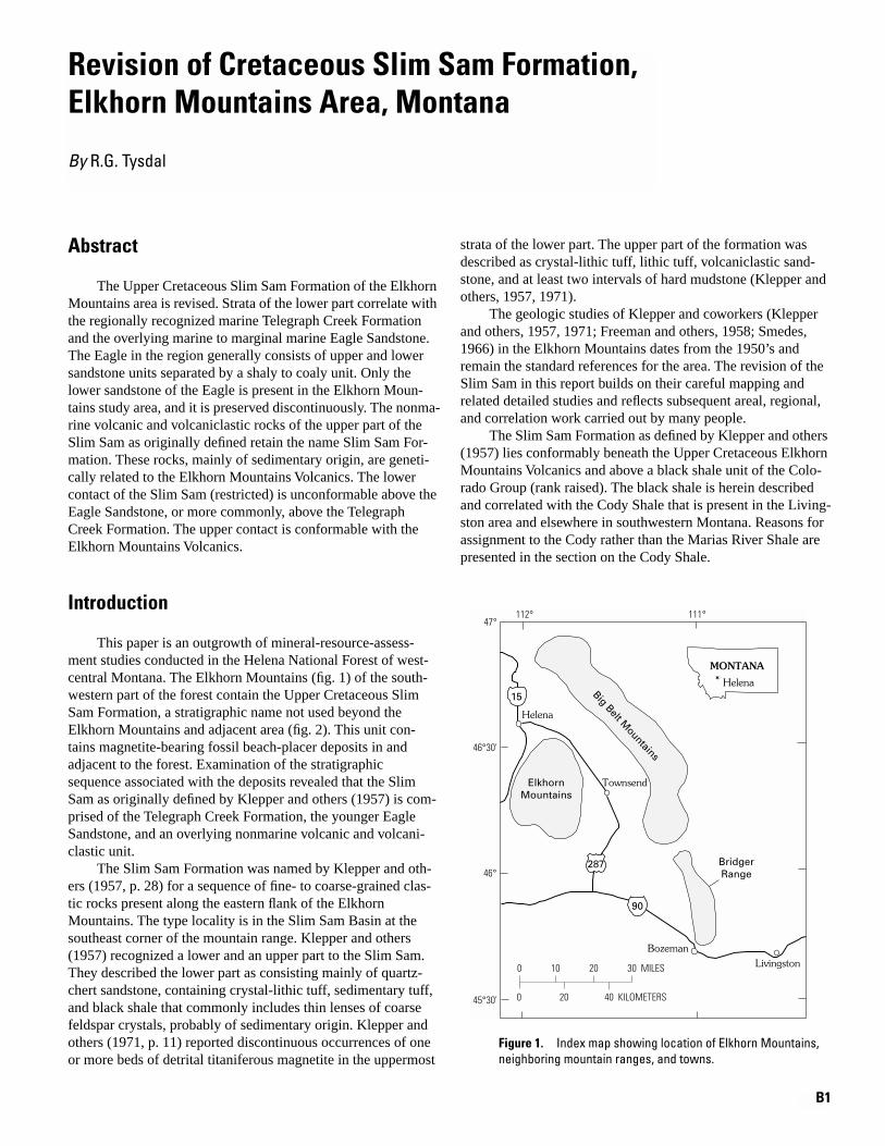
B1
Helena
MONTANA
0 10 20 30 MILES
0 20 40 KILOMETERS
LivingstonBozeman
Townsend
Helena
111°112°47°
46°30'
46°
45°30'
ElkhornMountains
BridgerRange
Big Belt Mountains
z15
z90
287
Revision of Cretaceous Slim Sam Formation,Elkhorn Mountains Area, Montana
By
R.G. Tysdal
Abstract
The Upper Cretaceous Slim Sam Formation of the Elkhorn Mountains area is revised. Strata of the lower part correlate with the regionally recognized marine Telegraph Creek Formation and the overlying marine to marginal marine Eagle Sandstone. The Eagle in the region generally consists of upper and lower sandstone units separated by a shaly to coaly unit. Only the lower sandstone of the Eagle is present in the Elkhorn Moun-tains study area, and it is preserved discontinuously. The nonma-rine volcanic and volcaniclastic rocks of the upper part of the Slim Sam as originally defined retain the name Slim Sam For-mation. These rocks, mainly of sedimentary origin, are geneti-cally related to the Elkhorn Mountains Volcanics. The lower contact of the Slim Sam (restricted) is unconformable above the Eagle Sandstone, or more commonly, above the Telegraph Creek Formation. The upper contact is conformable with the Elkhorn Mountains Volcanics.
Introduction
This paper is an outgrowth of mineral-resource-assess-ment studies conducted in the Helena National Forest of west-central Montana. The Elkhorn Mountains (fig. 1) of the south-western part of the forest contain the Upper Cretaceous Slim Sam Formation, a stratigraphic name not used beyond the Elkhorn Mountains and adjacent area (fig. 2). This unit con-tains magnetite-bearing fossil beach-placer deposits in and adjacent to the forest. Examination of the stratigraphic sequence associated with the deposits revealed that the Slim Sam as originally defined by Klepper and others (1957) is com-prised of the Telegraph Creek Formation, the younger Eagle Sandstone, and an overlying nonmarine volcanic and volcani-clastic unit.
The Slim Sam Formation was named by Klepper and oth-ers (1957, p. 28) for a sequence of fine- to coarse-grained clas-tic rocks present along the eastern flank of the Elkhorn Mountains. The type locality is in the Slim Sam Basin at the southeast corner of the mountain range. Klepper and others (1957) recognized a lower and an upper part to the Slim Sam. They described the lower part as consisting mainly of quartz-chert sandstone, containing crystal-lithic tuff, sedimentary tuff, and black shale that commonly includes thin lenses of coarse feldspar crystals, probably of sedimentary origin. Klepper and others (1971, p. 11) reported discontinuous occurrences of one or more beds of detrital titaniferous magnetite in the uppermost
strata of the lower part. The upper part of the formation was described as crystal-lithic tuff, lithic tuff, volcaniclastic sand-stone, and at least two intervals of hard mudstone (Klepper and others, 1957, 1971).
The geologic studies of Klepper and coworkers (Klepper and others, 1957, 1971; Freeman and others, 1958; Smedes, 1966) in the Elkhorn Mountains dates from the 1950’s and remain the standard references for the area. The revision of the Slim Sam in this report builds on their careful mapping and related detailed studies and reflects subsequent areal, regional, and correlation work carried out by many people.
The Slim Sam Formation as defined by Klepper and others (1957) lies conformably beneath the Upper Cretaceous Elkhorn Mountains Volcanics and above a black shale unit of the Colo-rado Group (rank raised). The black shale is herein described and correlated with the Cody Shale that is present in the Living-ston area and elsewhere in southwestern Montana. Reasons for assignment to the Cody rather than the Marias River Shale are presented in the section on the Cody Shale.
Figure 1.
Index map showing location of Elkhorn Mountains, neighboring mountain ranges, and towns.

B2 Revision of Middle Proterozoic Yellowjacket Formation and Cretaceous Slim Sam Formation
Elkhorn
Radersburg
Winston
EastHelena
Helena
Qu
Kg Ke Cretaceous Elkhorn Mountains Volcanics and related intrusions Ks Cretaceous Slim Sam Formation (restricted), Telegraph Formation, and Eagle Sandstone
MzPz Mesozoic and Paleozoic rocks, undivided Yu Middle Proterozoic rocks, undivided
EXPLANATION
YuKe
Ke
Qu
Qu
Ke
Ke
Ke
KsMzPz
MzPz
Ks
MzPz
MzPz
Kg
Kg
Kg
Qu
Qu
Kg
Kg
MzPz
MzPz
Qu
Kg
Kg
Ks
Cor
ral
C
reek
Sheep
Cre
ek
Indian
Cr
Weston Cr
Crow
Creek
0 1 2 3 4 5 6 MILES
0 2 4 6 8 KILOMETERS
111°45'112°
46°30'
46°15' Slim SamBasin
IronCrossmine
Measuredsection
BigMountain
287
z15
ELKHORN MOUNTAINS
Cretaceous granite and related intrusions
Quaternary sediments, undivided
Figure 2.
Geologic map showing outcrop area of Slim Sam Forma-tion as originally defined by Klep-per and others (1957) and as herein redefined to include the Telegraph Creek Formation, the discontinuously present Eagle Sandstone, and the Slim Sam For-mation (restricted). The Indian Creek reference section of the Slim Sam (restricted) is indicated. Compiled from maps of Klepper and others (1957, 1971), Freeman and others (1958), Smedes (1966), and Knopf (1963).

Revision of Cretaceous Slim Sam Formation, Elkhorn Mountains Area, Montana B3
The purpose of this paper is to redefine the Slim Sam, restricting the name to the volcanic and volcaniclastic rocks and applying the two regionally established formation names to the other units. The Slim Sam Formation (restricted), the Eagle Sandstone, and Telegraph Creek Formation are sepa-rated from the Slim Sam as originally defined—these forma-tions and the Cody Shale beneath the sequence are described, correlated, and discussed in descending order in the follow-ing sections. All identifications of megafossils were made by W.A. Cobban.
Slim Sam Formation (Restricted)
The Slim Sam Formation (restricted) consists of medium-gray to gray-green nonmarine volcanic and volcaniclastic rocks that constitute the upper part of the Slim Sam as origi-nally defined by Klepper and others (1957). The Slim Sam (restricted) contains a few beds of pyroclastic tuff but mainly consists of volcanic debris reworked by sedimentary pro-cesses. Some beds appear massive and are fine- to medium-grained epiclastic tuff composed almost wholly of angular grains of plagioclase, small fragments of fine-grained volca-nic rocks, and less abundant grains of quartz, mica, horn-blende, and opaque minerals, set in a microcrystalline groundmass altered to chlorite and sericite (Klepper and oth-ers, 1957, 1971). Sandstone beds commonly are amalgamated into units that are clearly stratified, exhibit both planar and trough crosslamination, local lenses of mudstone or rip-up clasts of mudstone, and zones of well-rounded volcanic peb-bles. Some volcaniclastic sandstone units are laterally lenticu-lar over several tens of meters. Scouring and channeling were noted by Smedes (1966) in the northwestern part of the out-crop area. The above described strata tend to be resistant and form outcrops. Poorly exposed sandstone, siltstone, mud-stone, and locally porcellanite, form recessive strata. Most beds of the formation are noncalcareous.
Measured thicknesses include 155 m (508 ft) near Sheep Creek in the northwestern extent of the formation (Smedes, 1966) and 201 m (659 ft) near Indian Creek (this study) (fig. 2). The upper unit of the Slim Sam of Smedes (1966) repre-sents the restricted Slim Sam of this study. Thicknesses mea-sured by Klepper and others (1957) do not distinguish the upper part (Slim Sam as herein restricted) from the lower part (Eagle Sandstone and Telegraph Creek Formation). A readily accessible reference section for the Slim Sam (restricted) is the Indian Creek section of Klepper and others (1957, p. 30–31) (fig. 2; N
1
/
2
SW
1
/
4
and S
1
/
2
NW
1
/
4
sec. 6, T. 6 N., R. 1 E.), starting about 122 m (400 ft) above the base.
Eagle Sandstone
Rocks here assigned to the Eagle Sandstone constitute the uppermost strata of the lower part of the Slim Sam Formation as originally defined by Klepper and others (1957). The for-mation is described and discussed because (1) its local and regional character aid demonstration of the unconformable
nature of the upper contact, thus providing a basis for interpreting the stratigraphic history of the sequence of rocks and for restricting rocks assigned to the Slim Sam, (2) it is used as the key stratigraphic unit for regional correlation, and (3) it hosts strandline placer deposits.
The Eagle was named by Weed (1899) from exposures in north-central Montana, where the formation consists of an upper thin-bedded buff-colored sandstone unit, a middle unit of coaly and carbonaceous rocks, and a lower ledge-forming unit of hard white sandstone. The lower sandstone unit later was named the Virgelle Sandstone Member (Bowen, in Stebinger, 1914). In the Elkhorn Mountains, only strata of the Virgelle and lowermost part of the middle unit are preserved.
The Eagle of the Elkhorn Mountains is here correlated with Eagle strata in the vicinity of Livingston, Mont. (fig. 1), where the Eagle has been carefully examined and mapped over a broad area (Roberts, 1972, and maps cited therein). In the Livingston area, the sandstones and intervening coal-bearing strata of the Eagle have been mapped separately from overly-ing somber-colored volcaniclastic strata, which were assigned to the conformably overlying Cokedale Formation of the Liv-ingston Group (Roberts, 1972; Weed, 1893). The Eagle con-sists mainly of delta-plain and beach deposits. The basal sandstone, the Virgelle Sandstone Member, is as much as 34 m (110 ft) thick and is conformable with the underlying Tele-graph Creek Formation (Roberts, 1972).
The Eagle Sandstone thins northwestward from the Liv-ingston area, ranging from about 183 m (600 ft) in the south-ern part of the Bridger Range to about 30 m (100 ft) in the northern part (McMannis, 1955) (fig. 1). McMannis (1955, p. 1407) stated that the formation is prominent in the southern and middle parts of the range but becomes inconspicuous and difficult to locate in the northern part. The basal contact is not well exposed.
Northward, within and adjacent to the southernmost part of the Big Belt Mountains, Skipp and Peterson (1965) reported that the Eagle ranges from 30–91 m (100–300 ft) thick. The Eagle, and locally the underlying Telegraph Creek Formation, are unconformably overlain by volcanic and volcaniclastic rocks of the Maudlow Formation, which is considered to be an isolated remnant of the same volcanic field of which the Elkhorn Mountains Volcanics are a part (Skipp and Peterson, 1965; Skipp and McGrew, 1977).
It is clear from the above data that the basal sandstone of the Eagle decreases in thickness and prominence northwest-ward from the Livingston area toward the Elkhorn Mountains and that the formation is directly overlain by volcanic and vol-caniclastic rocks. As noted by Roberts (1972, p. 31), rocks above the Eagle in central and western Montana range from marine to nonmarine, and, where they are nonmarine, the top of the Eagle generally is placed at the lithologic change where volcanic detritus becomes abundant. The restriction of the Slim Sam as defined herein follows this general relationship and par-allels the stratigraphic and sedimentologic usage of the Living-ston area in and adjacent to the southernmost part of the Big Belt Mountains.
In the Elkhorn Mountains, the basal Virgelle Sandstone Member of the Eagle is present only locally. The best

B4 Revision of Middle Proterozoic Yellowjacket Formation and Cretaceous Slim Sam Formation
exposure, and thickest known preserved sequence, is in a bull-dozer trench west of Big Mountain (fig. 2). In the trench, and in the roadcut of the access road leading to it, the Eagle con-sists of feldspar-chert-quartz sandstone overlain by silty sand-stone, and then medium-grained magnetite-bearing sandstone that also contains hornblende, chert, quartz, and feldspar. The latter intertongues with, and is overlain by, planar-bedded fine-grained sandstone that is devoid of trace fossils. Upward, this sandstone contains lenses of mudstone that display traces of plant rootlets. These uppermost exposed strata are interpreted as basal strata of the middle unit of the Eagle.
The magnetite-bearing sandstone and the sandstone with which it intertongues are interpreted as back-beach deposits. This interpretation is in agreement with that of Klepper and others (1957, 1971) and Houston and Murphy (1977) for mag-netite-bearing deposits at the Iron Cross mine west of Raders-burg (fig. 2), from which ore has been mined (Reed, 1951). The planar-bedded sandstone grades upward into the mud-stone and rootlet-bearing strata interpreted as delta-plain deposits. Sandstone in the roadcut leading to the trench possi-bly also was deposited in a beach, but its poor and discontinu-ous exposure prevents making a reliable determination. Volcanic and volcaniclastic rocks of the Slim Sam overlie this sequence of rocks.
Foreshore (beach) deposits were observed about 1 km (0.6 mi) southeast of the top of Big Mountain and along the road directly south of Weston Creek (fig. 2). At both locations, the basal Eagle is light-gray, fine- to medium-grained, quartz and feldspar (“salt-and-pepper”) sandstone that has very little matrix and displays planar and trough crosslaminated beds. At these two localities, the lower Eagle is overlain by volcanic and (or) volcaniclastic rocks of the Slim Sam Formation (restricted). Upper foreshore deposits, such as magnetite-bear-ing sandstone and delta-plain strata, are absent.
Telegraph Creek Formation
The Telegraph Creek Formation is transitional between the Cody Shale and the overlying Eagle Sandstone. In the Elkhorn Mountains, the transitional position is reflected in the upward-changing makeup of the formation. The lower part consists of interbedded dark-gray mudstone and shale, similar to that of the underlying Cody Shale, and interbedded clayey and silty fine-grained sandstone. The sandstone content increases upsection; the grain size generally increases from fine to medium grained; and the clay and silt content of the sandstone decreases. Sandstone is calcareous throughout the formation. Trace fossils are common throughout the forma-tion, changing in type upward and recording shallowing depo-sitional conditions. Horizontal traces, indicative of lower shoreface and offshore environments (Pemberton and others, 1992), are common on sandstone beds in lower strata of the formation. In the upper strata, steeply inclined to vertical bur-rows of
Ophiomorpha
and
Diplocraterion
, indicative of mid-dle and upper shoreface environments, and thoroughly burrowed (churned) sandstone units are interstratified with pla-nar, unburrowed sandstone beds.
Cody Shale
Basal strata of the Telegraph Creek Formation are con-formable and gradational with the underlying shale that was assigned to the upper black shale unit of the Colorado Group by Klepper and others (1957). This upper black shale unit is here correlated with the Cody Shale of the Livingston area (fig. 1), where it directly underlies the Eagle Sandstone. Three sections of the Cody measured by Klepper and others (1957, p. 28; their upper black shale unit of the Colorado Group) in the eastern part of the Elkhorn Mountains range from 81 to 119 m (265 to 390 ft) thick.
The black shale is assigned to the Cody rather than to the Marias River Shale that constitutes the upper shale of the Col-orado Group in north-central Montana for the following rea-sons. The Marias River consists of four members, which, in descending order, are the Kevin, Ferdig, Cone, and Floweree Shale Members. The Floweree (mainly marine fissile shale) and Cone Members (chiefly calcareous shale) (Cobban and others, 1976) are absent in the Elkhorn Mountains. The Fer-dig (mainly dark bluish-gray shale with a medial sandy shale—Cobban and others, 1976) also is absent in the Elkhorn Mountains. The time zone of the Ferdig is represented by sandstone, which is more similar to sandstone of the Frontier Formation than shale of the Ferdig. The Kevin lithology (mainly shale, bentonitic in the lower part, and containing limestone concretions of differing character in different parts of the member—Cobban and others, 1976) is present in the Elkhorn Mountains, where it contains more siltstone and fewer concretions than is reported to the north by Cobban and oth-ers (1976) and Schmidt (1978). This lithology also is typical of the Cody. The Cody name is used for the shale unit in the Elkhorn Mountains because (1) the Frontier is succeeded by the Cody Shale in southwestern Montana and the type sec-tions of both formations in Wyoming, and (2) the Marias River Shale (or the Kevin Member) nomenclature is not used for rocks overlying the Frontier.
Age
Based on the limited data available at the time of their field studies, Klepper and others (1957, p. 37) stated that the basal part of the Elkhorn Mountains Volcanics could be as old as the Telegraph Creek Formation because the Slim Sam For-mation (as originally defined), which contains “Niobrara” (age) fossils (i.e., Telegraph Creek age) in its lower part, “appears to have been deposited rapidly” and to grade upward into the volcanic rocks at some localities. Klepper and others (1971) later stated that the Slim Sam could be as young as the Eagle Sandstone, but no younger, because the overlying Elkhorn Mountains Volcanics are only slightly younger than the Eagle. We now know that the Elkhorn Mountains Volca-nics are younger than the Eagle Sandstone and the Slim Sam (restricted). The Elkhorn Mountains Volcanics are above the Slim Sam (restricted) and lie unconformably on the Telegraph Creek and the Eagle; thus, they are younger than all of the clastic-bearing formations.

Revision of Cretaceous Slim Sam Formation, Elkhorn Mountains Area, Montana B5
The maximum age of strata previously assigned to the Slim Sam Formation by Klepper and others (1957) is limited by the age of the Cody Shale, which underlies the Telegraph Creek For-mation. The bivalve
Cremnoceramus deformis
(Meek) (previ-ously
Inoceramus deformis
), from the basal middle Coniacian zone of
Forresteria alluaudi
, was collected from basal strata of Fauna recovered from somewhat higher in the Cody include
Scaphites ventricosus
Meek and Hayden and associated middle Coniacian fossils
Baculites asper
Morton,
Volviceramus umbonatus
(Meek and Hayden), and
Pseudoxybeloceras dispar
Kennedy and Cobban (Klepper and others, 1957; Kennedy and Cobban, 1991).
Fossils recovered from the Telegraph Creek range from middle Coniacian through upper Santonian (fig. 3).
Scaphites
cf.
S. ventricosus
Meek and Hayden was recovered from the basal 15 m (50 ft) of the Telegraph Creek (Slim Sam of Klepper and others, 1957) (Klepper and others, 1971).
Scaphites
sp. and
Mag-adiceramus subquadratus crenelatus
Seitz of the slightly younger
Scaphites depressus
zone were recovered during this study from shale near the base of the Telegraph Creek Formation southeast of Big Mountain (fig. 2). The pelecypod
Cymbophora arenaria
(Meek) (previously
Mactra arenaria
) was recovered from as high as 116 m (380 ft) above the base of the Telegraph Creek Formation (Klepper and others, 1957, p. 29), as well as about 60 m (200 ft) above the base at another locality (Klepper and others, 1971, p. 11–12). From near Big Mountain,
Cymbo-phora arenaria
(Meek) was recovered during this study from the uppermost exposed part of the Telegraph Creek Formation, about 20 m (66 ft) below the base of exposed strata of the Eagle Sand-stone. (Strata within the 20 m (66 ft) is covered; hence, the base of the Eagle could be, and probably is, less than 20 m (66 ft) above the horizon that yielded
Cymbophora arenaria
(Meek).)
Clioscaphites
cf.
C. novimexicanus
(Reeside), an ammonite probably from one of the upper Santonian
Desmoscaphites
zones (W.A. Cobban, written commun., 1994), was obtained from about 22 m (72 ft) below the base of exposed Eagle strata at the same locality.
The above fauna from the Telegraph Creek Formation indicates that the Eagle Sandstone is no older than late Santo-nian. The preserved Eagle strata likely represent only a slightly younger age, but the time span of the eroded Eagle strata is not well confined. A minimum age for preserved Eagle Sandstone, the Slim Sam Formation (restricted), and the time span repre-sented by the unconformity between the two is limited by the age of the overlying Elkhorn Mountains Volcanics. Eruption of these rocks took place from about 81 to 76 Ma (Rutland and others, 1989). The most recent radiometric dates on the volca-nics are two potassium-argon determinations of Tilling and oth-ers (1968) from rocks within the lower member of the sequence. The dates are 79.6 and 80.2 Ma, and average 79.9 Ma (recalculated from 77.6 and 78.2, and 78.0+1.7 Ma, respec-tively, using decay constants of Steiger and Jager, 1977, and conversion tables of Dalrymple, 1979). With these radiometric dates, the time span between the base of the Eagle and rocks within the lower member of the Elkhorn Mountains Volcanics is about 4 m.y.
Tilling (1974, p. 1927) suggested that the Elkhorn Moun-tains Volcanics may have been reheated during intrusion of the
Boulder batholith; thus, the dates may be reduced. However, unreheated volcanic rocks of the apparently genetically related rocks of the Maudlow Formation at the southern end of the Big Belt Mountains yielded a radiometric date of 80.9 Ma from the lower part of the formation (Skipp and McGrew, 1977) (recalcu-lated from 78.9+1 Ma, using decay constants of Steiger and Jager, 1977, and conversion tables of Dalrymple, 1979). This date suggests that the dates on the Elkhorn Mountains Volcanics are reasonable.
Discussion and Conclusions
The nonmarine volcanic- and volcaniclastic-rich Slim Sam Formation (restricted) records early history of the Elkhorn Mountains Volcanics. The sandstones were formed of volcanic particles eroded from the initial extrusives and were redeposited by sedimentary processes. Even though the rocks are mainly of sedimentary origin, they are nonmarine strata genetically related to the Elkhorn Mountains Volcanics and not to marine strata of the Telegraph Creek Formation and marine to marginal marine delta-plain deposits of the Eagle Sandstone. This interpretation helps to explain the geographically variable thickness of the non-marine Slim Sam (restricted); the variability of the sedimentary versus volcanic components of the unit; and internal discontinui-ties within the Slim Sam (restricted) in some areas, but apparent conformity in other areas. Further, the interpretation is consistent with the regional pattern of marine Eagle Sandstone being sepa-rate and distinct from directly overlying volcanic and volcani-clastic rocks.
The lower part of the sequence of strata that constituted the Slim Sam Formation as originally defined by Klepper and others (1957) is everywhere represented by marine strata of the Tele-graph Creek Formation, deposited in the zone of transition between the offshore deposits of the Cody Shale and the strand-line to lowermost delta-plain deposits of the basal part of the Eagle Sandstone. Regional data show the Eagle to consist of a basal and upper sandstone and an intermediate coaly to carbon-aceous unit. Only the basal sandstone and lowermost strata of the middle part were observed in the Elkhorn Mountains, and they are preserved only locally. The absence of part or all of the Eagle, and deposition of the nonmarine rocks of the Slim Sam (restricted) directly on lower shoreface to offshore marine strata of the Telegraph Creek Formation throughout much of the area reveals that an unconformity lies at the base of the Slim Sam (restricted), even though no angular discordance is evident in some areas.
Klepper and others (1957, 1971) stated that the contact of the Slim Sam Formation (as originally defined) with the overly-ing Elkhorn Mountains Volcanics ranged from conformable to unconformable. They believed this contact was conformable along the eastern flank of the Elkhorn Mountains, northward from near Radersburg, Mont. (fig. 2). Southward from near Rad-ersburg, and elsewhere in the Elkhorn Mountains, Klepper and others (1971, p. 21) stated that the Slim Sam and older rocks were folded and eroded before extrusion of the volcanics. Sepa-ration of the Slim Sam (as they defined the formation) into the

B6 Revision of Middle Proterozoic Yellowjacket Formation and Cretaceous Slim Sam Formation
Baculites scottiBaculites gregoryensisBaculites perplexus (late form)Baculites gilbertiBaculites perplexus (early form)Baculites sp. (smooth)Baculites asperiformisBaculites maclearni
Baculites obtususBaculites sp. (weak flank ribs)Baculites sp. (smooth)Scaphites hippocrepis IIIScaphites hippocrepis II
Scaphites hippocrepis I
Desmoscaphites bassleriDesmoscaphites erdmaniiClioscaphites choteauensisClioscaphites vermiformisInoceramus undulatoplicatus Clioscaphites saxitonianus
Scaphites depressus, Protexanites bourgeoisianusScaphites ventricosus
Forresteria alluaudi, Scaphites preventicosusForresteria peruana
WESTERN INTERIOR ZONE FOSSILS (No specific Ar-Ar age has been determined for fossils in braces)
MIL
LIO
N Y
EA
RS
(m
.y.)
S
TAG
E(b
ased
on
zo
ne
foss
ils)
Ar-
Ar
AG
E (m
.y.)
80.54
78
80
82
84
86
88
81.71
83.91
84.88
86.92
88.34
ELKHORN MOUNTAINS
This report
Klepper andothers (1957)
?
?
?
?
Elkhorn
Mountains
Volcanics (part)
Elkhorn
Mountains
Volcanics (part)
Eagle Sandstone
Telegraph
Creek
Formation
Slim
Sam
Formation
CodyShale
Upper blackshale unit of Colorado Formation
Co
nia
cian
San
toni
anC
amp
ania
n (
par
t)
Slim Sam Fm(restricted)
Figure 3.
Correlation chart showing relationships in the Elkhorn Mountains. Boundaries of the Upper Cretaceous stages, Western Interior fossil zones, and 40Ar/39Ar radiometric ages are adapted from Obradovich (1993). Ages in the Ar-Ar column correspond to specific, indicated zone fossils in the column headed “Western Interior Zone Fossils.” Fossils within braces in the latter column are not tied to specific ages, and no age (or age range) is implied other than biostratigraphic position within the sequence and the age constraints afforded by zone fossils that have been dated. Individual zone fossils, or sequences of zone fossils, within braces could be slightly younger or older than indicated by position in the figure. In the columns headed “Elkhorn Mountains,” a query symbol indicates uncertainty in correspon-dence of the formation contact with a fossil zone or radiometric age. The column subheaded “Klepper and others (1957)” shows lithofacies correlation, but not necessarily age correlation, with the column subheaded “this report.”

Revision of Cretaceous Slim Sam Formation, Elkhorn Mountains Area, Montana B7
Telegraph Creek, Eagle, and Slim Sam (restricted) indicates that erosion, and probably folding, occurred before deposition of the Slim Sam (restricted). The reasoning is as follows.
The upper contact of the Slim Sam (restricted) is conform-able with the overlying Elkhorn Mountains Volcanics along the east flank of the Elkhorn Mountains, as determined by Klepper and others (1957, 1971) and by my observations as well. The upper contact also is conformable in the northernmost part of the Elkhorn Mountains, in the Sheep Creek to Corral Creek area (fig. 2) (Smedes, 1966, p. 21). The upper contact is an angular unconformity along the southern flank of the Elkhorn Moun-tains, several kilometers west of Radersburg, where the Elkhorn Mountains Volcanics lie on the Slim Sam Formation (Klepper and others, 1957, pl. 1). Similarly, the upper contact is uncon-formable southward from near Radersburg, where the Elkhorn Mountains Volcanics lie directly on Slim Sam and older strata (Freeman and others, 1958, pl. 1). But the Slim Sam of the maps of Klepper and others (1957) and Freeman and others (1958) in both of these areas may be Telegraph Creek Formation, and the Slim Sam (restricted) could be absent. If volcanic rocks rest directly on Telegraph Creek strata in these areas, then deforma-tion before or after deposition of the Slim Sam (restricted) can-not be determined from these areas.
The lower contact of the Slim Sam (restricted) is uncon-formable above older strata. In the Indian Creek area (fig. 2), it rests on lower shoreface deposits of the Telegraph Creek For-mation. In the Crow Creek–Weston Creek area, and in the Big Mountain area, it rests on the Telegraph Creek and, locally, on lower strata of the Eagle Sandstone. These data show that the Slim Sam (restricted) does not represent continuous deposi-tion from Telegraph Creek or Eagle strata and indicates that erosion and perhaps deformation took place prior to deposi-tion of the Slim Sam (restricted). Further work in the Elkhorn Mountains may show that the strata remaining within the Slim Sam Formation may more properly be assigned to the Elkhorn Mountains Volcanics.
References Cited
Cobban, W.A., Erdmann, C.E., Lemke, R.W., and Maughn, E.K., 1976, Type sections and stratigraphy of the members of the Blackleaf and Marias River Formations (Cretaceous) of the Sweetgrass Arch, Montana: U.S. Geological Survey Professional Paper 974, 66 p.
Dalrymple, G.B., 1979, Critical tables for conversion of K-Ar ages from old to new constants: Geology, v. 7, p. 558–560.
Freeman, V.L., Ruppel, E.T., and Klepper, M.R., 1958, Geology of part of the Townsend Valley, Broadwater and Jefferson Counties, Montana: U.S. Geological Survey Bulletin 1042-N, p. 481–556.
Houston, R.S., and Murphy, J.F., 1977, Depositional environment of Upper Cretaceous black sandstones of the Western Interior: U.S. Geological Survey Professional Paper 994-A, 29 p.
Kennedy, W.J., and Cobban, W.A., 1991, Coniacian ammonite faunas from the United States Western Interior: The Paleontological Association, Special Papers in Paleontology, no. 45, 96 p.
Klepper, M.R., Ruppel, E.T., Freeman, V.L., and Weeks, R.A., 1971, Geology and mineral deposits, east flank of the Elkhorn Moun-tains, Broadwater County, Montana: U.S. Geological Survey Pro-fessional Paper 665, 66 p.
Klepper, M.R., Weeks, R.A., and Ruppel, E.T., 1957, Geology of the southern Elkhorn Mountains, Jefferson and Broadwater Coun-ties, Montana: U.S. Geological Survey Professional Paper 292, 82 p.
Knopf, Adolph, 1963, Geology of the northern part of the Boulder bath-ylith and adjacent area, Montana: U.S. Geological Survey Miscel-laneous Investigations Series Map I-381, scale 1:48,000.
McMannis, W.J., 1955, Geology of the Bridger Range, Montana: Geo-logical Society of America Bulletin, v. 66, p. 1385–1430.
Obradovich, J.D., 1993, A Cretaceous time scale,
in
Caldwell, W.G.E., and Kauffman, E.G., eds., Evolution of the Western Interior Basin: Geological Association of Canada, Special Paper 39, p. 379–396.
Pemberton, S.G., MacEachern, J.A., and Frey, R.W., 1992, Trace fossil facies models; environmental and allostratigraphic significance,
in
Walker, R.G., and James, N.P, eds., Facies Models—Response to Sea Level Change: Geological Association of Canada, p. 47–72.
Reed, G.C., 1951, Mines and mineral deposits (except fuels), Broadwa-ter County, Montana: U.S. Bureau of Mines Information Circular 7592, 58 p.
Roberts, A.E., 1972, Cretaceous and Early Tertiary depositional and tectonic history of the Livingston area, southwestern Montana: U.S. Geological Survey Professional Paper 526-C, 120 p.
Rutland, Carolyn, Smedes, H.W., Tilling, R.I., and Greenwood, W.R., 1989, Volcanism and plutonism at shallow crustal levels; the Elkhorn Mountains Volcanics and the Boulder batholith, south-western Montana,
in
Hyndman, D.W., ed., Cordilleran Volcanism, Plutonism, and Magma Generation at Various Crustal Levels, Montana and Idaho: 28th International Geological Congress, Field Trip Guidebook T337, p. 16–31.
Schmidt, R.G., 1978, Rocks and mineral resources of the Wolf Creek area, Lewis and Clark and Cascade Counties, Montana: U.S. Geo-logical Survey Bulletin 1441, 91 p.
Skipp, Betty, and McGrew, L.W., 1977, The Maudlow and Sedan For-mations of the Upper Cretaceous Livingston Group on the west edge of the Crazy Mountains Basin, Montana: U.S. Geological Survey Bulletin 1422-B, 68 p.
Skipp, Betty, and Peterson, A.D., 1965, Geologic map of the Maudlow quadrangle, southwestern Montana: U.S. Geological Survey Mis-cellaneous Investigations Series Map I-452, scale 1:24,000.
Smedes, H.W., 1966, Geology and igneous petrology of the northern Elkhorn Mountains, Jefferson and Broadwater Counties, Mon-tana: U.S. Geological Survey Professional Paper 510, 116 p.
Stebinger, Eugene, 1914, Titaniferous magnetite on the Blackfeet Indi-an Reservation, Montana: U.S. Geological Survey Bulletin 540-H, p. 329–337.
Steiger, R.H., and Jager, E., 1977, Subcommission on geochronolo-gy—Convention on the use of decay constants in geo- and cos-mochronology: Earth and Planetary Science Letters, v. 36, p. 359–362.
Tilling, R.I., 1974, Composition and time relations of plutonic and asso-ciated volcanic rocks, Boulder batholith region, Montana: Geo-logical Society of America Bulletin, v. 85, p. 1925–1930.
Tilling, R.I., Klepper, M.R., and Obradovich, J.D., 1968, K-Ar ages and time span of emplacement of the Boulder batholith, Montana: American Journal of Science, v. 266, p. 671–689.

B8 Revision of Middle Proterozoic Yellowjacket Formation and Cretaceous Slim Sam Formation
Weed, W.H., 1893, The Laramie and the overlying Livingston Formation in Montana: U.S. Geological Survey Bulletin 105, 68 p.
———1899, Description of the Fort Benton quadrangle, Montana: U.S. Geological Survey Geological Atlas, Folio 55, 9 p.
Published in the Central Region, Denver, ColoradoManuscript approved for publication March 12, 1998Edited by Richard W. Scott, Jr.Graphics by R.G. TysdalPhotocomposition by Gayle M. Dumonceaux