Embed Size (px)
Citation preview
1
Reyes Peak Forest Health and Fuels Reduction Project Project Proposal
May 8, 2020
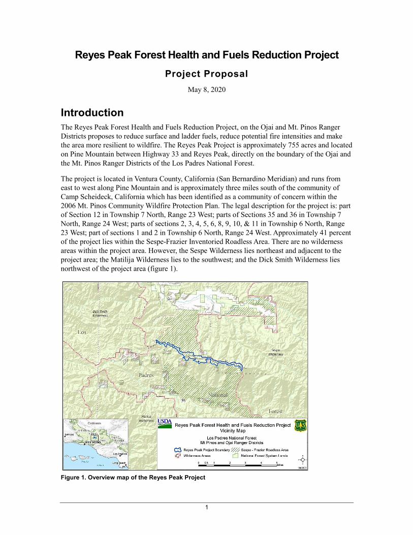
Introduction The Reyes Peak Forest Health and Fuels Reduction Project, on the Ojai and Mt. Pinos Ranger Districts proposes to reduce surface and ladder fuels, reduce potential fire intensities and make the area more resilient to wildfire. The Reyes Peak Project is approximately 755 acres and located on Pine Mountain between Highway 33 and Reyes Peak, directly on the boundary of the Ojai and the Mt. Pinos Ranger Districts of the Los Padres National Forest.
The project is located in Ventura County, California (San Bernardino Meridian) and runs from east to west along Pine Mountain and is approximately three miles south of the community of Camp Scheideck, California which has been identified as a community of concern within the 2006 Mt. Pinos Community Wildfire Protection Plan. The legal description for the project is: part of Section 12 in Township 7 North, Range 23 West; parts of Sections 35 and 36 in Township 7 North, Range 24 West; parts of sections 2, 3, 4, 5, 6, 8, 9, 10, & 11 in Township 6 North, Range 23 West; part of sections 1 and 2 in Township 6 North, Range 24 West. Approximately 41 percent of the project lies within the Sespe-Frazier Inventoried Roadless Area. There are no wilderness areas within the project area. However, the Sespe Wilderness lies northeast and adjacent to the project area; the Matilija Wilderness lies to the southwest; and the Dick Smith Wilderness lies northwest of the project area (figure 1).
Figure 1. Overview map of the Reyes Peak Project
Reyes Peak Proposed Action
2
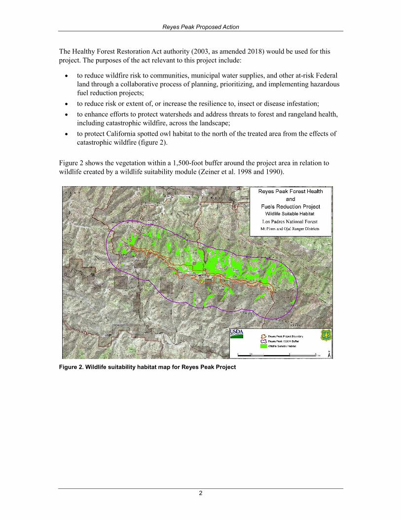
The Healthy Forest Restoration Act authority (2003, as amended 2018) would be used for this project. The purposes of the act relevant to this project include:
• to reduce wildfire risk to communities, municipal water supplies, and other at-risk Federal land through a collaborative process of planning, prioritizing, and implementing hazardous fuel reduction projects;
• to reduce risk or extent of, or increase the resilience to, insect or disease infestation; • to enhance efforts to protect watersheds and address threats to forest and rangeland health,
including catastrophic wildfire, across the landscape; • to protect California spotted owl habitat to the north of the treated area from the effects of
catastrophic wildfire (figure 2).
Figure 2 shows the vegetation within a 1,500-foot buffer around the project area in relation to wildlife created by a wildlife suitability module (Zeiner et al. 1998 and 1990).
Figure 2. Wildlife suitability habitat map for Reyes Peak Project
Reyes Peak Proposed Action
3
Background Information/Existing Condition
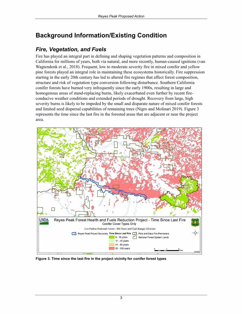
Fire, Vegetation, and Fuels Fire has played an integral part in defining and shaping vegetation patterns and composition in California for millions of years, both via natural, and more recently, human-caused ignitions (van Wagtendonk et al., 2018). Frequent, low to moderate severity fire in mixed conifer and yellow pine forests played an integral role in maintaining these ecosystems historically. Fire suppression starting in the early 20th century has led to altered fire regimes that affect forest composition, structure and risk of vegetation type conversion following disturbance. Southern California conifer forests have burned very infrequently since the early 1900s, resulting in large and homogenous areas of stand-replacing burns, likely exacerbated even further by recent fire-conducive weather conditions and extended periods of drought. Recovery from large, high severity burns is likely to be impeded by the small and disparate nature of mixed conifer forests and limited seed dispersal capabilities of remaining trees (Nigro and Molinari 2019). Figure 3 represents the time since the last fire in the forested areas that are adjacent or near the project area.
Figure 3. Time since the last fire in the project vicinity for conifer forest types
Reyes Peak Proposed Action
4
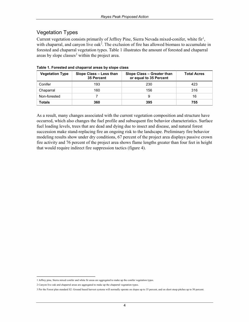
Vegetation Types Current vegetation consists primarily of Jeffrey Pine, Sierra Nevada mixed-conifer, white fir1, with chaparral, and canyon live oak2. The exclusion of fire has allowed biomass to accumulate in forested and chaparral vegetation types. Table 1 illustrates the amount of forested and chaparral areas by slope classes3 within the project area.
Table 1. Forested and chaparral areas by slope class Vegetation Type Slope Class – Less than
35 Percent Slope Class – Greater than
or equal to 35 Percent Total Acres
Conifer 193 230 423 Chaparral 160 156 316 Non-forested 7 9 16 Totals 360 395 755
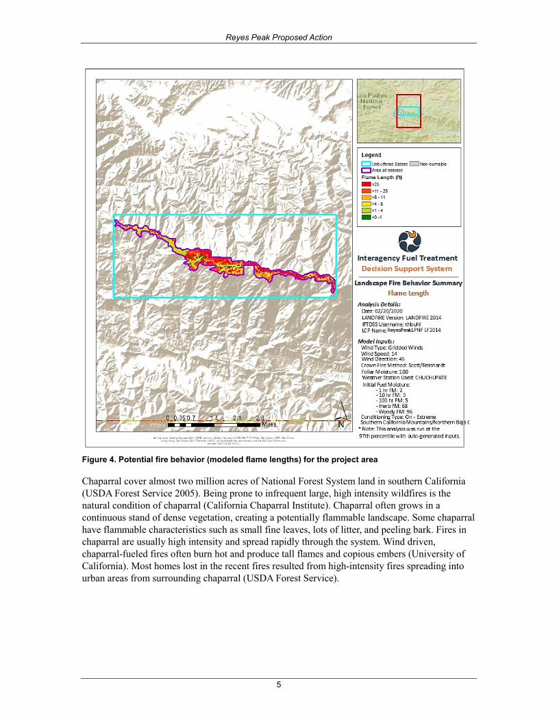
As a result, many changes associated with the current vegetation composition and structure have occurred, which also changes the fuel profile and subsequent fire behavior characteristics. Surface fuel loading levels, trees that are dead and dying due to insect and disease, and natural forest succession make stand-replacing fire an ongoing risk to the landscape. Preliminary fire behavior modeling results show under dry conditions, 67 percent of the project area displays passive crown fire activity and 76 percent of the project area shows flame lengths greater than four feet in height that would require indirect fire suppression tactics (figure 4).
1 Jeffrey pine, Sierra mixed conifer and white fir areas are aggregated to make up the conifer vegetation types.
2 Canyon live oak and chaparral areas are aggregated to make up the chaparral vegetation types.
3 Per the Forest plan standard S2: Ground based harvest systems will normally operate on slopes up to 35 percent, and on short steep pitches up to 50 percent.
Reyes Peak Proposed Action
5
Figure 4. Potential fire behavior (modeled flame lengths) for the project area
Chaparral cover almost two million acres of National Forest System land in southern California (USDA Forest Service 2005). Being prone to infrequent large, high intensity wildfires is the natural condition of chaparral (California Chaparral Institute). Chaparral often grows in a continuous stand of dense vegetation, creating a potentially flammable landscape. Some chaparral have flammable characteristics such as small fine leaves, lots of litter, and peeling bark. Fires in chaparral are usually high intensity and spread rapidly through the system. Wind driven, chaparral-fueled fires often burn hot and produce tall flames and copious embers (University of California). Most homes lost in the recent fires resulted from high-intensity fires spreading into urban areas from surrounding chaparral (USDA Forest Service).
Reyes Peak Proposed Action
6
Fire Regime Groups4 Fire has played an important ecological role in the history of the ecosystems of the Los Padres National Forest. Approximately 8 million lightning strikes occur globally each day, and lightning starts more than 6,000 fires in the United States each year (Pyne 1982). Since the beginning of the early 20th century, the frequency of natural fire has decreased dramatically. This decrease has corresponded with an increased demand for wildland fire suppression to protect life and property.
The natural or historic fire regime is a general classification of the role fire plays in an ecosystem. The concept of a fire regime provides an integrated way of classifying the impacts of these diverse spatial and temporal patterns of fire and impacts of fire at an ecosystem or landscape level (Hardy et al. 1998).
Coarse scale definitions for natural (historical) fire regimes have been developed and interpreted for fire and fuels management. The five natural (historical) fire regimes are classified based on average number of years between fires (fire frequency) combined with the severity (amount of replacement) of the fire on the dominant over story vegetation (Hann and Bunnell 2001) and are displayed in table 2.
Table 2. Fire regime groups Fire Regime Group Frequency/Severity Severity Description
Fire Regime Group I 0-35 years, low/mixed severity
Generally low-severity fires replacing less than 25% of the dominant over story vegetation; can include mixed-severity fires that replace up to 75% of the over story.
Fire Regime Group II 0-35 years, replacement severity
High-severity fires replacing greater than 75% of the dominant over story vegetation.
Fire Regime Group III 35 – 200 years, mixed/low severity
Generally mixed-severity; can also include low-severity fires.
Fire Regime Group IV 35 – 200+ years, replacement severity
High-severity fires
Fire Regime Group V 200+ years, replacement/ any severity
Generally, replacement-severity; can include any severity type in this frequency range.
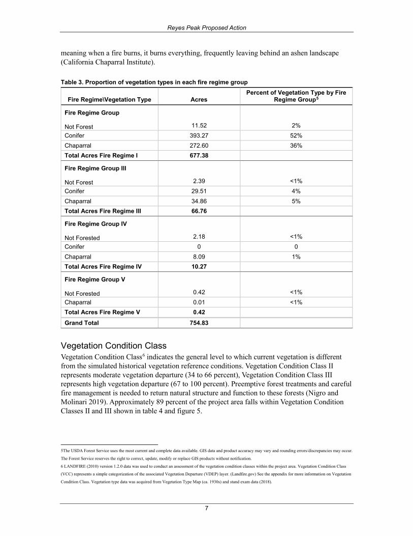
Approximately 89 percent of the Reyes Peak project area is classified as Fire Regime Group I with a less than 35-year fire return interval and a low/mixed fire severity. The proportion of vegetation types by acre and percentage are contained within each fire regime group and displayed in table 3.
In table 3, LANDFIRE data fire regime group data was intersected with vegetation types to show the distribution of vegetation types within mapped Fire Regime Groups in the project area. The natural fire return interval for chaparral is 30 to 150 years. Today, there are more fires than the chaparral ecosystem can tolerate (Chaparral Institute). As displayed in table 1, there are approximately 272 acres of the project area that is characterized as chaparral within Fire Regime Group I. Fire Regime Group I is defined as having a 0- to 35-year frequency with a low/mixed fire severity. The Chaparral Institute noted, chaparral has a high-intensity, crown fire regime,
4 LANDFIRE (2010) version 1.2.0 data was used to conduct an assessment of the fire regime groups (Landfire.gov) See the appendix for more information on Fire
Regime Groups.
Reyes Peak Proposed Action
7
meaning when a fire burns, it burns everything, frequently leaving behind an ashen landscape (California Chaparral Institute).
Table 3. Proportion of vegetation types in each fire regime group
Fire Regime\Vegetation Type Acres Percent of Vegetation Type by Fire
Regime Group5
Fire Regime Group Not Forest 11.52 2% Conifer 393.27 52% Chaparral 272.60 36% Total Acres Fire Regime I 677.38
Fire Regime Group III Not Forest 2.39 <1% Conifer 29.51 4% Chaparral 34.86 5% Total Acres Fire Regime III 66.76
Fire Regime Group IV Not Forested 2.18 <1% Conifer 0 0 Chaparral 8.09 1% Total Acres Fire Regime IV 10.27
Fire Regime Group V Not Forested 0.42 <1% Chaparral 0.01 <1% Total Acres Fire Regime V 0.42
Grand Total 754.83
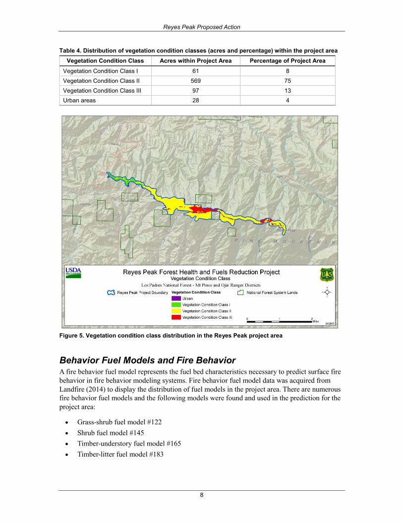
Vegetation Condition Class Vegetation Condition Class6 indicates the general level to which current vegetation is different from the simulated historical vegetation reference conditions. Vegetation Condition Class II represents moderate vegetation departure (34 to 66 percent), Vegetation Condition Class III represents high vegetation departure (67 to 100 percent). Preemptive forest treatments and careful fire management is needed to return natural structure and function to these forests (Nigro and Molinari 2019). Approximately 89 percent of the project area falls within Vegetation Condition Classes II and III shown in table 4 and figure 5.
5The USDA Forest Service uses the most current and complete data available. GIS data and product accuracy may vary and rounding errors/discrepancies may occur.
The Forest Service reserves the right to correct, update, modify or replace GIS products without notification.
6 LANDFIRE (2010) version 1.2.0 data was used to conduct an assessment of the vegetation condition classes within the project area. Vegetation Condition Class
(VCC) represents a simple categorization of the associated Vegetation Departure (VDEP) layer. (Landfire.gov) See the appendix for more information on Vegetation
Condition Class. Vegetation type data was acquired from Vegetation Type Map (ca. 1930s) and stand exam data (2018).
Reyes Peak Proposed Action
8
Table 4. Distribution of vegetation condition classes (acres and percentage) within the project area Vegetation Condition Class Acres within Project Area Percentage of Project Area
Vegetation Condition Class I 61 8 Vegetation Condition Class II 569 75 Vegetation Condition Class III 97 13 Urban areas 28 4
Figure 5. Vegetation condition class distribution in the Reyes Peak project area
Behavior Fuel Models and Fire Behavior A fire behavior fuel model represents the fuel bed characteristics necessary to predict surface fire behavior in fire behavior modeling systems. Fire behavior fuel model data was acquired from Landfire (2014) to display the distribution of fuel models in the project area. There are numerous fire behavior fuel models and the following models were found and used in the prediction for the project area:
• Grass-shrub fuel model #122• Shrub fuel model #145• Timber-understory fuel model #165• Timber-litter fuel model #183
Reyes Peak Proposed Action
9
Timber-understory fuel model #165 comprises approximately 40 percent (305 acres) of the project area and consists of a very high load or timber with understory shrubs and small trees. Fire behavior rate of spread and flame lengths are moderate in this fuel model. Grass-shrub fuel model #122 comprises approximately 36 percent (269 acres) of the project area and consists of a moderate load of grasses and shrubs. Fire rate of spread is high and flame length is moderate in this fuel model. A very high load of shrubs (fuel model #147) comprises approximately 4 percent and is characterized by high fire rates of spread and flame lengths. Timber-litter fuel model #183 makes up approximately three percent of the area and typically exhibits very low rates of spread and low flame lengths. Fuel models comprising less than 2 percent of the project area are not discussed in detail (Landfire 2014).
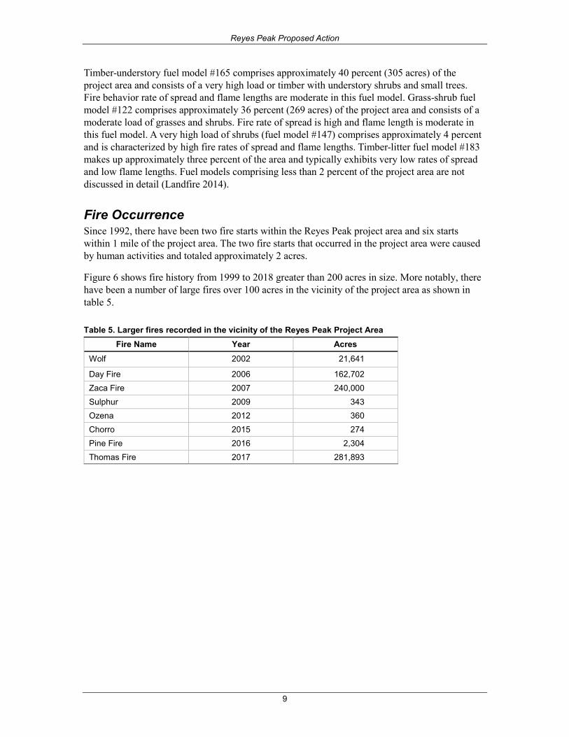
Fire Occurrence Since 1992, there have been two fire starts within the Reyes Peak project area and six starts within 1 mile of the project area. The two fire starts that occurred in the project area were caused by human activities and totaled approximately 2 acres.
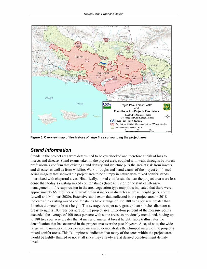
Figure 6 shows fire history from 1999 to 2018 greater than 200 acres in size. More notably, there have been a number of large fires over 100 acres in the vicinity of the project area as shown in table 5.
Table 5. Larger fires recorded in the vicinity of the Reyes Peak Project Area Fire Name Year Acres
Wolf 2002 21,641
Day Fire 2006 162,702 Zaca Fire 2007 240,000 Sulphur 2009 343 Ozena 2012 360 Chorro 2015 274 Pine Fire 2016 2,304 Thomas Fire 2017 281,893
Reyes Peak Proposed Action
10
Figure 6. Overview map of fire history of large fires surrounding the project area
Stand Information Stands in the project area were determined to be overstocked and therefore at risk of loss to insects and disease. Stand exams taken in the project area, coupled with walk-throughs by Forest professionals confirm that existing stand density and structure puts the area at risk from insects and disease, as well as from wildfire. Walk-throughs and stand exams of the project confirmed aerial imagery that showed the project area to be clumpy in nature with mixed conifer stands intermixed with chaparral areas. Historically, mixed conifer stands near the project area were less dense than today’s existing mixed conifer stands (table 6). Prior to the start of intensive management in fire suppression in the area vegetation type map plots indicated that there were approximately 65 trees per acre greater than 4 inches in diameter at breast height (pers. comm. Lowell and Molinari 2020). Extensive stand exam data collected in the project area in 2018 indicates the existing mixed conifer stands have a range of 0 to 180 trees per acre greater than 4 inches diameter at breast height. The average trees per acre greater than 4 inches diameter at breast height is 100 trees per acre for the project area. Fifty-four percent of the measure points exceeded the average of 100 trees per acre with some areas, as previously mentioned, having up to 180 trees per acre greater than 4 inches diameter at breast height. Table 6 illustrates the densification that has occurred in the project area over the past 90 years. Also, of note, the wide range in the number of trees per acre measured demonstrates the clumped nature of the project’s mixed conifer areas. This “clumpiness” indicates that many of the acres within the project area would be lightly thinned or not at all since they already are at desired post-treatment density levels.
Reyes Peak Proposed Action
11
Table 6. Trees per acre (TPA): Historic versus existing conditions Trees Per Acre by Year 4 - 12" 12 - 24" 24 - 36" > 36" Total/Range
1930 Ave TPA Acres 20 34 2 9 65
2018 Ave TPA Acres 9 44 34 13 100
1930 Range TPA Acre 5 - 50 20 - 45 0 - 10 0 - 35 0 - 45
2018 Range TPA Acre 0 - 100 20 - 180 20 - 140 0 - 80 0 - 180
Comparing the 1930s stand exam data with the stand exams from 2018, there are more trees per acre in the project area, but the existing trees are generally larger7 than under historic conditions. In some areas, it would be necessary to thin up to 24 inches diameter at breast height to alleviate the density-induced stress on the larger trees.
The project area contains approximately 423 acres of mixed conifer dominated stands (table 1). These stands are experiencing elevated levels of bark beetle activity, California fivespined ips (Ips paraconfusus) and pinyon ips (Ips confusus), and associated increasing tree mortality that has been exacerbated by the ongoing drought. The project area was identified in the National Insect and Disease Forest Risk Assessment of 2012 (NIDFRA) as being at risk from both of these beetles. According to the risk rating models used by the Risk Assessment, the areas proposed for treatment in this project are categorized as high risk for pests that could destroy over 25 percent of basal area due to current forest conditions. This mortality combined with stand structure and drought is increasing the risk of a stand-replacing wildfire.
Additionally, modelling of insect and disease risk for the proposed treatment units using the Forest Vegetation Simulator shows a moderate to high risk of mortality from beetle infestation. According to Oliver (1995), Jeffrey and pinyon pine trees, in stands where basal areas are over 120 square feet of basal area per acre, are at imminent risk of bark beetle-associated mortality. The average existing basal area in our pine and mixed conifer stand is slightly over 120 basal area with many stands well in excess of that threshold. Treatments that reduce stocking or densities below this threshold significantly reduce risk and potentially high mortality if bark beetles invade treated stands. Prevention is not guaranteed but improves the chances that bark beetles would bypass treated stands in search for more preferable conditions.
Within the project area, there are approximately 316 acres of chaparral. The extreme drought in recent years has increased the risk to the campgrounds and California spotted owl habitat in the area. Some drought-related mortality in the chaparral is evident within the project area. This drought mortality adds dead fuels to the landscape.
Desired Conditions The long-term goal of vegetation management is to perpetuate plant communities by maintaining or re-introducing fire regimes appropriate to each type, while at the same time protecting human communities from destructive wildland fires (USDA Forest Service 2005). In the long term, the desired condition for the national forest land would be to: (1) create forests more resistant to the 7 Large trees are defined by the Forest Plan as those larger than 24 inches diameter at breast height. Small trees are those less than 24 inches diameter at breast
height. LMP, Part 2 Implement vegetation management activities to reduce tree densities and fuel loading in yellow pine and mixed conifer forests to levels similar to
those that characterized forests of the pre-suppression and early suppression eras (CA. 7880-1930). Restore species composition comparable to forests of the same
era with an emphasis on increasing the relative abundance of large-diameter (greater than 24 inches diameter breast height), shade-intolerant conifer species. LMP,
Part 2 Pg. 117.
Reyes Peak Proposed Action
12
effects of drought, insect and disease outbreaks, and stand-killing crown fires; (2) encourage tree recruitment that contain a species mix more like pre-settlement composition, (with a higher representation of shade-intolerant species such as ponderosa pine that have declined during the period of fire suppression); (3) re-create stand densities more like those of the pre-suppression era; and (4) encourage a stand structure that emphasizes large-diameter trees.
Thinning to remove ladder fuels and reduce canopy cover is generally recommended to minimize crown fire hazard (J. H. Scott ad Reinhardt 2001). The reduction in crown fire potential provides for increased success of fire suppression and also reduces the risk to firefighters and the public in a suppression action. The decrease in crown fire potential also allows fire managers to use more tools in suppression efforts.
In addition, the reduction in the potential for crown fire reduces the likelihood of reduced forest health. The risk of losing forest structure and continuity is high in large severe burning fires that produce crown fire. Forest diversity is also lost in large landscape fires that burn at high intensity.
Lowering flame lengths decreases the likelihood that there would be crown fire initiation. Lowering flame lengths increases the ability to actively suppress fires effectively during a severe fire season. Using hand crews is the most effective way to attack wildfires; hand crews are generally not effective with flame lengths over 4 feet in height. The activities proposed reduce the flame lengths in treatment units, so hand crews can be utilized.
Six percent, approximately 311 acres, of the Sespe-Frazier Inventoried Roadless Area lies within the project area. This inventoried roadless area lies within the Sespe Place as described in the Land Management Plan (LMP), pages 80 to 82. The program emphasis, in part is to continue to serve as a high quality primitive recreation area and wildlife refuge for varied species, including the California condor, and focus on reducing risks from wildland fire to maintain ecosystem stability and promote a natural fire regime. Fuel treatments are ongoing in Tecuya Mountain, Cuddy Valley, and Frazier Mountain areas, and multiple fire lines within the inventoried roadless area have been used during fire management operations. Dozer lines have been continuously re-opened within the project area as a result of the Day, Zaca, Pine, and Thomas fires. Overall, the Sespe-Frazier Inventoried Roadless Area has low wilderness values and characteristics with uses that cannot be effectively managed as wilderness (LMP amendment, p. 25).
The understory ladder fuels, existing hazardous fuel loads and continued periods of drought place these areas at risk from wildfire. The existing condition of the project area is not in line with the goals and desired conditions derived from the Forest Plan as described below and the 2000 National Strategic Plan Goal 1 – Reduce the risk from catastrophic wildland fire. In addition, the National Fire Plan was developed following a landmark wildland fire season, with the intent of actively responding to severe wildland fires and their impacts to communities while ensuring sufficient firefighting capacity for the future. It addresses five key points: firefighting, rehabilitation, hazardous fuels reduction, community assistance, and accountability.
The National Strategy (Final Phase in the Development of NCWFMS 2014) recognizes and accepts fire as a natural process necessary for the maintenance of many ecosystems, and strives to reduce conflicts between fire-prone landscapes and people. By simultaneously considering the role of fire in the landscape, the ability of humans to plan for and adapt to living with fire, and the need to be prepared to respond to fire when it occurs, the Cohesive Strategy takes a holistic approach to the future of wildland fire management.
Reyes Peak Proposed Action
13
Land Management Plan Direction The Los Padres National Forest Land Management Plan consists of three parts: (1) Southern California National Forests Vision (USDA 2005a), (2) Los Padres National Forest Strategy (USDA 2005b), and (3) Design Criteria for the Southern California National Forests (USDA 2005c).
The Reyes Peak Project is consistent with the Southern California Forests Vision (Part 1), the Los Padres National Forest Strategy (Part 2) and the Design Criteria for the Southern California National Forests (Part 3).
The Southern California National Forests Vision (USDA 2005a) includes the following goals that states, in part:
• Goal 1.1 - Community Protection (USDA 2005a, p. 20). Improve the ability of southern California communities to limit loss of life and property and recover from the high intensity wildland fires that are a natural part of this state’s ecosystem.
• Goal 1.2 - Restoration of Forest Health (USDA 2005a, p. 21). Restore forest health where alteration of natural fire regimes has put human and natural resource values at risk.
• Goal 1.2.1 - Fire Regime I (0 to 35 years - low severity) (USDA 2005a, p. 23). Reduce the potential for widespread losses of montane conifer forests caused by severe, extensive, stand-replacing fires.
• Goal 1.2.2 - Reduce the number of acres at risk from excessively frequent fires while improving defensible space around communities (USDA 2005a, pp. 26-27). In addition to protecting urban areas, strategically placed blocks of young chaparral around certain forest types (montane conifer and bigcone Douglas-fir forests) could be used to reduce the risk of crown fires. For example, burning chaparral around bigcone Douglas-fir forests (a key habitat of California spotted owl) could reduce tree mortality in wildland fires. Likewise, burning at the interface of chaparral and these forests could reduce the spread of crown fires.
• Goal 6.2 - Biological Resource Condition (USDA 2005a, p. 45). Provide ecological conditions to sustain viable populations of native and desired non-native species.
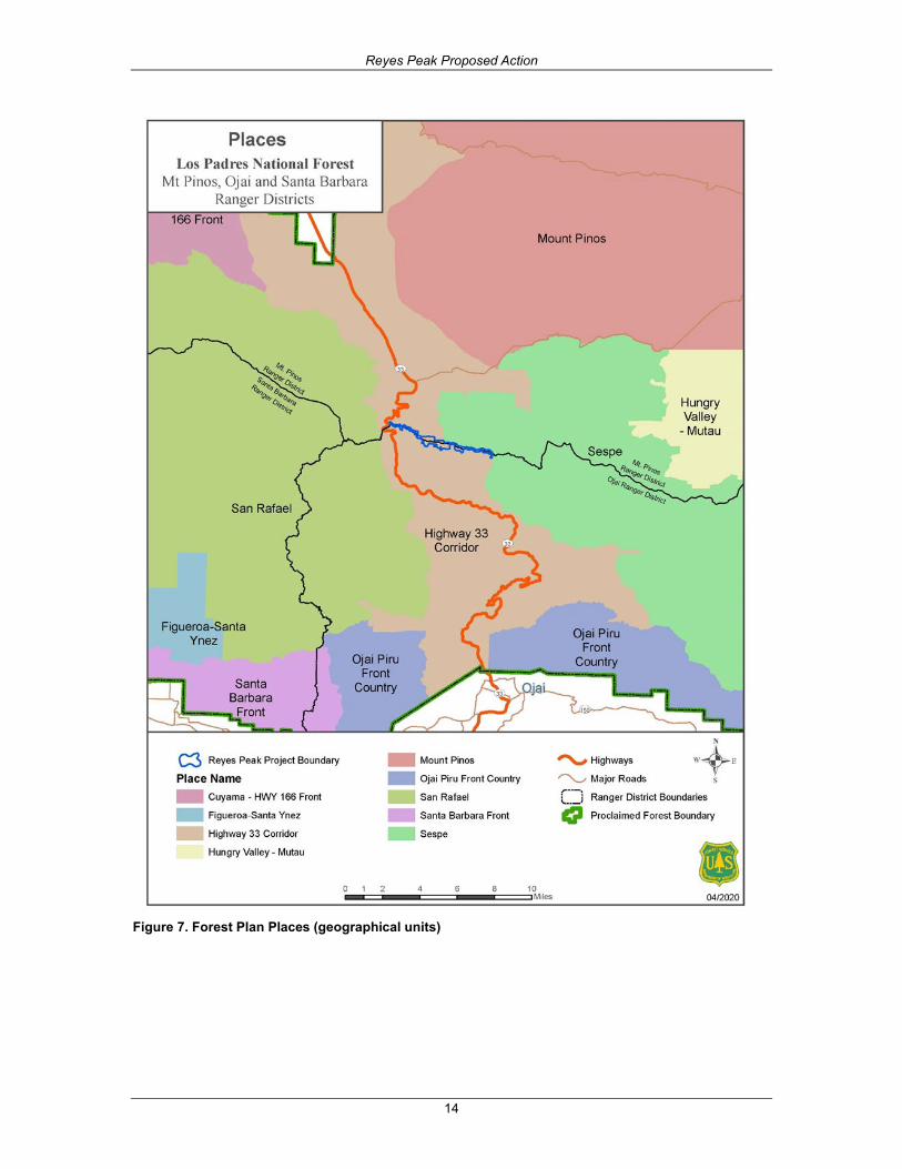
The Reyes Peak project is within two “places” (figure 7) as described in the Los Padres National Forest Strategy (LMP 2005b).
Reyes Peak Proposed Action
14
Figure 7. Forest Plan Places (geographical units)

Reyes Peak Proposed Action
15
The Sespe Place program emphasis includes, in part:
• “focus will be on reducing risks from wildland fire to maintain ecosystem stability and promote a natural fire regime”
• “continue to serve as a high quality primitive recreation area and wildlife refuge for varied species, including the California condor”
The Highway 33 Corridor Place program emphasis includes, in part:
• Vegetation management includes the creation of community defense zones around urbanized areas while addressing forest health and wilderness values.
• Focus on reducing risks from wildland fire to maintain water and scenic quality.
The Los Padres National Forest Strategy also outlines program strategies and tactics (LMP 2005b, Appendix B). These strategies and tactics for the restoration of forest health include:
• Implement vegetation management activities to reduce tree densities and fuel loading in yellow pine and mixed conifer forests to levels similar to those that characterized forest of the pre-suppression and early suppression eras (ca. 1880 to 1930). Restore species composition comparable to forests of the same era with an emphasis on increasing the relative abundance of large-diameter (greater than 24 inches diameter at breast height), shade-intolerant conifer species.
• Remove ladder fuels and forest floor fuel accumulations to protect stands of bigcone Douglas-fir from stand-replacing crown fires8. Reduce fuel loading in chaparral adjacent to fir stands so that future fires are less likely to initiate crown fires from surrounding shrublands.
• Manage Critical Biological land use zones so that activities and discretionary uses are either neutral or beneficial for the species and habitats for which the area was established.
• Treat fuel loading in chaparral to reduce the likelihood that fires originating in this type would generate crown fires in adjacent forested stands.
• Thin conifer stands to prevent water stress and damage by bark beetles. • Maintain the existing system of roadside fuelbreaks and fuelbreaks along watershed
boundaries to minimize fire size and the number of communities threatened by both fires and floods.
Purpose and Need The purpose of the project is to provide safe and effective locations from which to perform fire suppression operations, to slow the spread of a wildland fire at these strategic fuelbreak locations, and to reduce the potential for the loss of life, property, and natural resources. Approximately 1,200 acres of suitable California spotted owl roosting and foraging habitat is located on the north slope of Reyes Peak. Protecting this habitat is a priority to help reduce habitat loss from high intensity fires (LMP, Part 1, p. 46). There is a need to reduce surface and ladder fuels, reduce potential fire intensities and make the area more resilient to wildfire. Surface fuel loading levels, trees that are dead and dying due to insect and disease, and natural forest succession make 8 Bigcone Douglas-fir stands are adjacent to, not within, the project boundary.

Reyes Peak Proposed Action
16
stand-replacing fire an ongoing risk to the landscape. Historically, periodic lower intensity fire would reduce surface fuel levels naturally and thin stands, thereby reducing the risk of stand-replacing wildfire. The current fire regime has been influenced by decades of fire suppression, and therefore, removing natural fire as a process on the landscape.
The project area is close to the wildland-urban interface (approximately 3 miles from the community of Camp Scheideck) and there is a concern if a large wildfire were to occur in the area. Removing standing and down fuels reduces fuel loading levels and increases our ability to directly suppress wildfires in a safe and efficient manner. Important infrastructure lies within or adjacent to the project area, including the community of Camp Scheideck, Reyes Peak Campground, and the Ozena Fire Station.
This area was identified in the 2015 Strategic Fuel Break Assessment as an area needing treatment and the area was recently opened up under the Thomas fire when they installed a firebreak along the ridgeline. Past fire suppression activities have led to unstable conditions in the mixed conifer and pinyon-juniper stands by allowing widespread accumulation of fuels in the form of litter accumulations, coarse woody debris, and understory growth of shrubs and conifer regeneration (Goforth and Minnich 2008). The existing hazardous fuel levels including understory ladder fuels, existing fuel loads, and continued periods of drought place the stands at risk from wildfire.
The Los Padres National Forest Strategy includes a prescribed fire annual need goal of 10,000 acres. Some projects placed in this category are part of an overall landscape mosaic designed to limit the spread of wildland fire. Prescribed fire is also used to help restore and maintain lands in the coniferous forest areas, currently categorized as Condition Class 1 or 2 (USDA Forest Service 2005). The strategy includes an annual need of 400 acres of fuelbreak construction. Most of the planned fuelbreaks are also along roads and ridgetops and are proposed for limiting the spread of wildland fire. Fuelbreaks are sometimes constructed near communities to provide some level of future protection in cases where land ownership patterns or topography limit the applicability of the Wildland/Urban Interface Defense and Threat Zones concept (USDA Forest Service 2005).
The Land Management Plan 2005b, page 81 states, in part: with the exception of large periodic wildland fires, the natural fire regime has largely been excluded from the Sespe Place for many decades. Access for firefighting is limited to foot travel or aerial suppression, and there is very limited potential for motorized vehicle use during emergencies. Unlike most of the areas in the Sespe Place the proposed project is in an area where there is good access and is relatively close, 6-7 minutes to a fire station (Strategic Fuelbreak Assessment).
The Land Management Plan 2005b, page 59 states, in part: the vegetation of the Highway 33 Corridor and surrounding areas periodically experience numerous large, landscape-changing wildland fires that sometimes exceed 100,000 acres. Community protection from wildland fire is important to the area around Ojai and the many small blocks of private land that make up approximately 10 percent of the land base within the Corridor.
Reyes Peak Proposed Action
17
Proposed Action Prescribed fire and non-fire treatments are designed to achieve or trend toward the desired condition. The proposed treatments would reduce hazardous surface, ladder and crown fuels. The most appropriate fuel treatment strategy is often thinning (removing ladder fuels and decreasing crown density) followed by prescribed fire, piling and burning fuels. This proposal would create a variable-width, shaded fuelbreak9 in order to reduce fuel loading, and provide for firefighter and public safety. Fuelbreaks are sometimes constructed near communities to provide some level of future protection in cases where land ownership patterns or topography limit the applicability of the Wildland/Urban Interface Defense and Threat Zones concept (USDA Forest Service 2005, p. 22). To achieve this, various types of vegetation treatments are proposed including mechanical and hand thinning of trees and shrubs, mechanical and/or hand-piling and burning of cut material, mechanical mastication of smaller trees and shrubs, and prescribed pile burning and/or under burning.
Mixed conifer stands through-out the project area would be thinned to a range of 60 to 100 square feet basal area per acre with a target of 80 square feet per acre. High stocking levels, overlapping crown canopies, and a dense understory, contribute to resource competition, leaving trees in the project area at risk to more insect attack. Thinning to this level would allow us to reduce competition, remove fuels, improve health on the remaining trees and increase the overall average stand diameter. Outside of the inventoried roadless area, trees would be thinned between the less than 1-inch up to 24-inch diameter at breast height class, which is consistent with the Land Management Plan. Trees between the 24-inch and 64-inch diameter at breast height class would be retained unless removal is needed for safety reasons or if the trees are impacted by dwarf mistletoe. Worker safety is a priority for all projects and removal of trees in the 24-inch to 64-inch diameter at breast height class would be on a case-by-case basis to provide for the safety of employees, contractors and the public, and overall forest health.
Chaparral shrubs would be reduced by mastication or cutting by hand to meet project objectives and to establish an effective fuel break. A portion of the project area was previously used as a fire break during the Day, Zaca, Pine, and Thomas Fires. Fuel breaks are not designed to stop fire spread, especially during periods of strong winds when fire brands can be blown across these linear features (Agee et al. 2000). Fuel breaks can provide firefighting resources opportunities to construct fireline under less extreme fire weather conditions by providing areas of lower fire intensities and improved access.
Preference would be made to remove older more decadent chaparral over younger species. The ratio of dead to live fuel is much greater in old than in young chaparral and varies from species to species. Chaparral shrubs are very flammable due to the resinous foliage, woody stems, accumulated litter, and standing dead branches. Flammability of chaparral species increases over time through deposition of flammable leaf litter that contains volatile oils (SBCC 2020).
A portion of the project is within the Sespe-Frazier Inventoried Roadless Area. The Roadless Rule allows the cutting, sale, or removal of generally small diameter timber if needed "to maintain or restore the characteristics of ecosystem composition and structure, such as to reduce the risk of
9 Shaded fuelbreak: A linear path through a forested area in which surface and canopy fuel has been altered but where significant over story is retained to shade
surface fuels (firewords.net)
Reyes Peak Proposed Action
18
uncharacteristic wildfire effects, within the range of variability that would be expected to occur under natural disturbance regimes of the current climatic period" (36 CFR 294.13(b)(l)(ii)).
Consistent with the 2001 Roadless Area Conservation Rule, generally only smaller diameter timber would be cut or removed within the inventoried roadless area. Within the project area, trees range between 1-inch up to 64 inches diameter at breast height. The project is proposing to thin the lower one-half of the diameter class level within the inventoried roadless area between less than 1-inch and 23.9 inches diameter at breast height. Large trees are defined by the Forest Plan as those larger than 24 inches diameter at breast height (LMP Part 2). Small trees are those less than 24 inches diameter at breast height. Trees 24 inches diameter at breast height and larger would be retained within the project’s inventoried roadless area unless removal is needed for safety reasons or dwarf mistletoe infestations.
Proposed treatments are as follows and show in table 7:
Masticate - Shrubs and trees would be masticated throughout the project area. Mastication helps to moderate fire behavior by reducing fuel bed depth. To accomplish this, a tracked or rubber-tired machine chops, shreds, and/or grinds small trees, limbs, shrubs, and dead woody debris into chips. Mastication would be contingent on access and slope. Areas typically less than 35 percent slope would be chosen for mastication treatments.
Mechanical thinning - Thinning would use mechanized equipment to remove trees from the understory in order to reduce ladder fuels. Areas typically less than 35 percent slope would be chosen for thinning treatments.
Thin by Hand - This method of thinning trees and shrubs would involve the use of hand-tools or chainsaws to create a desired spacing. Hand thinning would be implemented on slopes greater than 35 percent or in other areas deemed unsuitable for mechanized equipment.
Lop and Scatter - Option in areas of steep slope determined ineffective for piling and safety concerns for implementation personnel.
Pruning Trees - Tree branches/limbs of remaining trees would be pruned using hand tools and chainsaws. Trees would be pruned approximately 8 to10 feet above ground level.
Firewood - Suitable cut trees would be made available for public firewood utilization.
Pile and Burn - Cut trees, shrubs, pruned limbs, and dead and down woody material would be piled by hand or by machine and subsequently burned. Piles would be located away from residual trees and shrub patches to minimize scorch to the canopies and trunks of trees.
Prescribed fire - Prescribed fire would be used in areas as determined by the responsible official. This would be accomplished by applying low to moderate intensity fire using hand firing methods including drip torches. Prescribed fire is used to minimize the potential for unwanted wildfires by reducing surface and ladder fuels and breaking up contiguous vegetation. It also enables fire managers to reintroduce fire to a fire-adapted ecosystem.
Hazard Tree Removal - The removal of hazard trees (live and dead) of all sizes would occur along roads, trails, campgrounds and landings to provide for safety of personnel and the public.
Reyes Peak Proposed Action
19
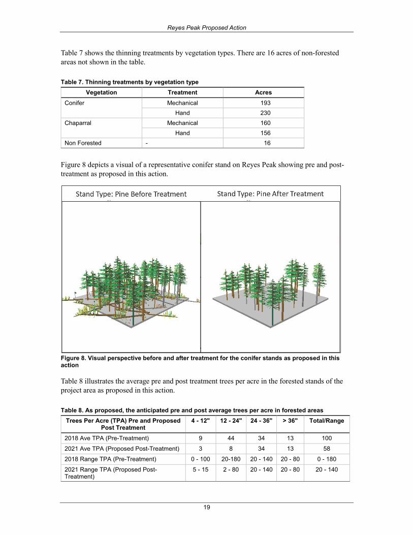
Table 7 shows the thinning treatments by vegetation types. There are 16 acres of non-forested areas not shown in the table.
Table 7. Thinning treatments by vegetation type Vegetation Treatment Acres
Conifer Mechanical 193 Hand 230 Chaparral Mechanical 160 Hand 156 Non Forested - 16
Figure 8 depicts a visual of a representative conifer stand on Reyes Peak showing pre and post-treatment as proposed in this action.
Figure 8. Visual perspective before and after treatment for the conifer stands as proposed in this action
Table 8 illustrates the average pre and post treatment trees per acre in the forested stands of the project area as proposed in this action.
Table 8. As proposed, the anticipated pre and post average trees per acre in forested areas Trees Per Acre (TPA) Pre and Proposed
Post Treatment 4 - 12" 12 - 24" 24 - 36" > 36" Total/Range
2018 Ave TPA (Pre-Treatment) 9 44 34 13 100
2021 Ave TPA (Proposed Post-Treatment) 3 8 34 13 58
2018 Range TPA (Pre-Treatment) 0 - 100 20-180 20 - 140 20 - 80 0 - 180
2021 Range TPA (Proposed Post-Treatment)
5 - 15 2 - 80 20 - 140 20 - 80 20 - 140

Reyes Peak Proposed Action
20
Design Elements Design elements are actions or instructions used to help avoid or reduce any unintended or negative effects of the project. Design elements are an important part of the proposed action and are proposed to protect sensitive wildlife, plants, habitats, soils, scenery, air quality, and historic and archaeological sites. Design elements incorporate applicable Forest Service Handbook and Manual direction, Forest Plan standards and guidelines, best management practices, conservation measures and any Terms and Conditions from appropriate Biological Opinions for threatened and endangered species and Programmatic Agreements for managing historic proprieties and cultural resources.
The following design elements are proposed and associated with the proposed action. The final decision may include more detailed measures. Additional design elements such as protection or mitigation measures or terms and conditions would be established in consultation with regulatory agencies.
Botanical Resources 1. Review sensitive species occurrence records from the Forest Service threatened, endangered,
and sensitive plant species database prior to project implementation.
2. Exclude heavy equipment operation from areas populated by sensitive species.
3. Avoid individuals within sensitive species populations during manual operations.
4. Exclude piling of material within areas populated by sensitive species.
5. If sensitive species populations not yet known are discovered within the project area, consultwith the forest personnel to ensure project design features are sufficient to provide forconservation of the botanical resource.
6. LMP-S32: When surveys for species presence/absence are done for threatened, endangered,and proposed species, use established survey protocols, where such protocols exist.
7. Use regionally approved standard clauses in contracts for equipment cleaning.
8. Earth-disturbing equipment used on National Forest System lands shall be cleaned to removeall visible plant parts, dirt, and material that may carry seed of non-native invasive species.Cleaning shall occur prior to entry into the project area and again upon leaving the projectarea, if implementation occurred within existing infestations.
9. Review existing infestations from the Forest Service invasive species inventory prior toimplementation.
10. Existing infestations should be avoided to the greatest practical extent.
11. Treatment activities which cannot avoid infested areas would employ risk reductionstrategies, such as working in infested areas last, working in infested areas when propagulesare not viable, limiting the number of people within the infested area, and cleaningequipment, clothing, etc. before moving to other un-infested National Forest System lands.
Fuels 1. Dead and down material left after treatment should be less than 10 tons per acre in the
forested treatment areas where available.
Reyes Peak Proposed Action
21
2. Selectively remove brush species along the edge of the fuel break to reduce the appearance of harsh edges.
3. All prescribed fire activities would occur with approvals from the appropriate local air pollution control district and under conditions established in an approved Prescribed Fire Burn Plan.
4. All burning would take place under the guidelines set forth in a prescribed fire burn plan developed specifically for this project area approved by the Responsible Official. Prescribed fire plans address parameters for weather, fire behavior, air quality and contingency resources.
5. Prescribed burning control lines would be constructed as needed for holding actions and/or to protect resource concerns. This includes black line, fireline, pruning, saw line and hose lays. Existing roads, trails and natural barriers would be used as control lines where possible.
6. Prescribed fire control lines adjacent to or that intersect existing roads and trails would be obliterated to reduce the potential for unauthorized use.
Heritage 1. Areas identified as impenetrable brush would be surveyed post-implementation.
2. Known heritage resources that can be impacted by operations would be flagged and protection measures would be applied.
3. No pile burning would occur within known heritage site boundaries.
4. Trees near known cultural resources would be felled away from site boundaries, to avoid damage to sensitive features or artifacts.
5. Upon ground disturbing activities, if unanticipated resources are discovered, cease project work in the area and notify the Forest Archaeologist and Tribal Liaison immediately. If human remains are uncovered, suspend activities immediately and notify the Forest Archaeologist, Tribal Liaison and local law enforcement. Project work in the area of the unanticipated discovery would not resume until the discovery has been secured and evaluated.
Hydrology and Soils 1. Designate season of use to avoid or restrict road use during periods when use would likely
damage the roadway surface or road drainage features. (National BMP Road-4. Road Operations and Maintenance).
2. Use suitable measures to avoid or minimize adverse effects to soil and watershed resources when proposed operations involve use of roads by traffic and during periods for which the road was not designed. (National BMP Road-4. Road Operations and Maintenance).
3. Refueling of equipment and storage of fuel and other hazardous materials would not occur within riparian conservation areas (perennial and seasonal streams, seeps, springs, and meadows). When landings are located within riparian conservation areas, refueling would occur outside riparian conservation areas in an approved refueling area. Use suitable measures around vehicle service storage, storage and refueling areas, chemical storage and

Reyes Peak Proposed Action
22
use areas, and waste dumps to fully contain spills and avoid or minimize soil contamination and seepage to groundwater. (National BMP Road-10. Equipment Refueling and Servicing).
4. Landing locations should be located outside of riparian conservation areas where possible,unless infeasible due to topography. Landings within riparian conservation areas may occurwhere there is existing disturbance (instead of constructing a new one); such landings wouldrequire special protective measures as specified by an earth scientist or biologist. (NationalBMP Veg-2. Erosion Prevention and Control).
5. Do not permit use of mechanical equipment on slopes greater than 35 percent or on steeperslopes with short pitches (National BMP Veg-2. Erosion Prevention and Control).
6. Operate equipment when soil compaction, displacement, erosion, and sediment runoff wouldbe minimized. (National BMP Veg-2. Erosion Prevention and Control).
7. Avoid ground equipment operations on unstable, wet, or easily compacted soils unlessoperation can be conducted without causing excessive rutting, soil puddling, or runoff ofsediments directly into waterbodies.
8. Riparian conservation areas would be 100 meters (328 feet) on perennial streams, or 30meters (98 feet) on intermittent streams, measured as the slope distance from either bank ofthe channel. Other special aquatic features, such as wetlands, seeps and springs, also have100-meter riparian conservation areas (National BMP Veg-3. Aquatic Management Zones).
9. No self-propelled ground-skidding equipment is allowed within the riparian conservationareas (exceptions would require input by an earth scientist or biologist as described inStandard 47 and Appendix E of the Land Management Plan).
10. There would be no removal of riparian plant species.
11. Within riparian conservation areas, retain snags and downed logs to the extent possible.Exceptions would be made if snags and logs are identified as a threat to life, property, orsustainability of riparian conservation areas (Standard 15, LMP Part 3, p. 6) (National BMPVeg-3. Aquatic Management Zones).
12. Water bars or leadout ditches may be constructed in firelines to minimize erosion. Water barsor leadout ditches would be installed according to the following recommended minimumintervals (table 9).
Table 9. Recommended minimum interval guidelines for the installation of water bars Fireline Gradient (% slope) Distance Between Water-Bars
(feet) Distance Between Water-Bars
(chains) 0 to 5 no water-bars needed no water-bars needed 6 to 15 200 3
16 to 30 100 1.5 31 to 49 75 1
> 50 50 0.5
Reyes Peak Proposed Action
23
Recreation 1. Where there is a safety concern for recreationists, implement temporary closures in the
project area. Ensure that sufficient public and internal notice is provided prior to thoseclosures.
2. Throughout the duration of the project, communicate with the recreational staff to coordinateclosures and/or consultation for privacy screening or potential off highway vehicle trespassduring implementation.
Silviculture 1. In all treatments, all live and dead trees posing a safety hazard to management activities or to
the public would be removed within the treated areas.
2. In all units, as soon as possible, and no longer than 24 hours after tree cutting, all activity-created fir and pine tree stumps greater or equal to 16 inches in diameter would be treatedwith a borax compound to inhibit the spread of annosus root disease.
3. All black oak encountered would be left unless they are deemed a hazard tree or if removal isneeded for operations.
Wildlife 1. LMP- S14: Where available and within the capability of the site retain a minimum of six
downed logs per acre (minimum 12 inches diameter and 120 total linear feet) and 10 to 15hard snags per 5 acres (minimum 16 inches diameter at breast height and 40 feet tall, or nextlargest available). Exception allowed in Wildland/Urban Interface Defense Zones, fuelbreaks,and where they pose a safety hazard. LMP - S15: Within riparian conservation areas retainsnags and downed logs unless they are identified as a threat to life, property, or sustainabilityof the riparian conservation area.
2. LMP - S17: In areas outside of Wildland/Urban Interface Defense Zones and fuelbreaks,retain soft snags and acorn storage trees unless they are a safety hazard, fire threat, orimpediment operability.
3. LMP - S18: Protect known active and inactive raptor nest areas. Extent of protection wouldbe based on proposed management activities, human activities existing at the onset of nestinginitiation, species, topography, vegetative cover, and other factors. When appropriate, a no-disturbance buffer around active nest sites would be required from nest-site selection tofledging.
4. LMP- S19: Protect all spotted owl territories identified in the Statewide CaliforniaDepartment of Fish and Game database (numbered owl sites) and new sites that meet the statecriteria by maintaining or enhancing habitat conditions over the long term to the greatestextent practicable while protecting life and property. Use management guidelines in thespecies conservation strategy (or subsequent species guidance document; see Appendix H) tofurther evaluate protection needs for projects, uses and activities.
5. LMP- S20: Maintain a limited operating period prohibiting activities within approximately0.25 miles of a California spotted owl nest site, or activity center where nest site is unknown,during the breeding season (February 1 through August 15), unless surveys confirm that theowls are not nesting. Follow the USDA Forest Service (1993, 1994 or subsequent) protocol to
Reyes Peak Proposed Action
24
determine whether owls are nesting. The limited operating period does not apply to existing road and trail use and maintenance, use of existing developed recreation sites, or existing special-uses, such as recreation residence tracts. When evaluating the need to implement a limited operating period, site- and project-specific factors need to be considered (use species management strategy or subsequent guidance; see Appendix H).
6. LMP- S28: Avoid or minimize disturbance to breeding and roosting California condors byprohibiting or restricting management activities and human uses within 1.5 miles of activeCalifornia condor nest sites and within 0.5 miles of active roosts.
7. Avoid rocky outcrops with mechanical treatments.
8. Trash associated with this project would be removed and properly disposed of. A forestwildlife biologist or designee would brief all personnel involved in implementing the projecton the importance of not leaving hazardous materials exposed and daily removal of allgarbage fragments to maintain condor health. Garbage removal would be stipulated inmechanical brush treatment contracts.
9. Workers would undergo “hazing” training pursuant to the September 3, 2014 CaliforniaCondor Recovery Program memo. If any California condors are attracted to work sites, thehazing measures would be implemented to avoid the possibility that the birds would becomehabituated to human activities, which poses a risk to their well-being.
10. Active goshawk nest stands (30 acres) would be avoided during project implementation. Thelimited operating period for goshawk within post-fledging family area (PFA) is March 1 -September 30. Treatments would only occur during the non-breeding season of October 1through February 28 if goshawks are found and determined to be nesting within the projectarea.
11. LMP-S32: When surveys for species presence/absence are done for threatened, endangered,and proposed species, use established survey protocols, where such protocols exist.
Reyes Peak Proposed Action
25
References Agee et al., 2000. The use of shaded fuelbreaks in landscape fire management. Forest and
Ecology Management, 127, pp. 55-66.
California Chaparral Institute. 2020. The Basics on Fire in the Chaparral. USGS Western Ecological Research Center. http://www.californiachaparral.com/fire/firenature.html
Goforth and Minnich 2008. Densifiati, stand-replacing wildlife, and extirpation of mixed conifer forest in Cuyamaca Rancho State Park, southern California Forest Ecology and Management 256.
Hann, W.J.; Bunnell, D.L. 2001 Fire and land management planning and implementation across multiple scales. Int. J. Wildland Fire. 10:389-403.
Hardy, C.C., Menakis, J.P. Brown, JK, 1998. Mapping Historic Fire Regimes for the Western United States: Integrating Remote Sensing and Biophysical Data.
J. H. Scott and Reinhardt 2001 Assessing Crown Fire Potential by Linking Models of Surface and Crown Fire Behavior. Research Paper RMRS-RP-29., Boise, ID. US Department of Agriculture, Forest Service. Rocky Mountain Research Station. 66 pages.
Nigro and Molinari 2019. Status and trends of fire activity in southern California yellow pine and mixed conifer forests. Forest Ecology and Management 441. Pages 20-31.
Oliver 1995. Is Self-Thinning in Ponderosa Pine Ruled by Dendroctonus Bark Beetles? In: Proceedings of the 1995 National Silvicultural Workshop. Mescalero, NM. General Technical Report RM-GTR-267. Fort Collins, CO. US Department of Agriculture, Forest Service. Rocky Mountain Forest and Range Experiment Research Pages 213-218.
Pyne SJ. 1982. Fire in America, A Cultural History of Wildland and Rural Fire. Seattle (WA): University of Washington Press. 654 p.
SBCC 2020. Santa Barbara City College Biological Sciences. Fire Ecology and the Chaparral. 2010. www.biosbcc.net/b100plant/htm/fire.htm
LANDFIRE 2010. version 1.2.0 data Vegetation Condition Class Categorization of Associated Vegetation Departure. https://www.Landfire.gov
USDA 2015. Strategic fuelbreak assessment for the Los Padres National Forest. Santa Lucia, Mt. Pinos, Ojai, and Santa Barbara Ranger District. Prepared by Adaptive Management Service Enterprise Team. US Department of Agriculture, Forest Service. 348 pages.
USDA 2012. National Best Management Practices for Water Quality Management on National Forest System Lands. Volume 1: National Core BMP Technical Guide. US Department of Agriculture, Forest Service. 177 pages. https://www.fs.fed.us/biology/resources/pubs/watershed/FS_National_Core_BMPs_April2012.pdf
Reyes Peak Proposed Action
26
USDA 2005. Land Management Plan Part 1 Vision. Angeles, Cleveland, Los Padres, San Bernardino National Forests. R5-MB-075. Land Management Plan Part 2 Los Padres National Forest Strategy. R5-MB-078. Land Management Plan Part 3 Design Criteria Angeles, Cleveland, Los Padres, San Bernardino National Forests. R5-MB-080. Pacific Southwest Region, CA. US Department of Agriculture, Forest Service. Los Padres National Forest. September 2005.
U.S. Fish and Wildlife Service. 2012. Protocol for Surveying Proposed Management Activities that may Impact Northern Spotted Owls. Endorsed by the U.S. Fish and Wildlife Service, February 2, 2011, Revised January 9, 2012. 42 pp.
U.S. Fish and Wildlife Service. 1992. Protocol for Surveying Proposed Management Activities that may Impact Northern Spotted Owls. 1992. Endorsed by the U.S. Fish and Wildlife Service. 7 March 1991, Revised March 17, 1992. 18 pp.
University of California. 2020. Climate, Fire, and Habitat in Southern California https://ucanr.edu/sites/SAFELandscapes/Fire_in_Southern_California_Ecosystems/
van Wagtendonk et al. 2018. Fire in California's Ecosystems (second ed.), University of California Press, California (2018).
Zeiner et al. 1998 and 1990 California Wildlife Habitat Relationships.
Reyes Peak Proposed Action
27
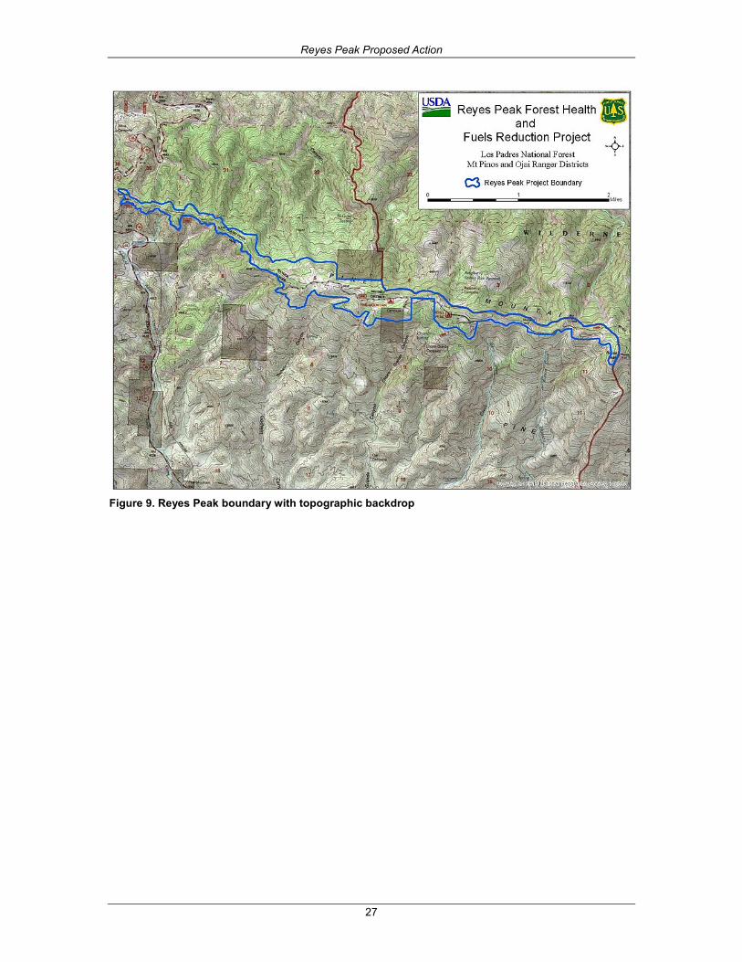
Figure 9. Reyes Peak boundary with topographic backdrop