Embed Size (px)
Citation preview
MEDIA RELEASE 4 September 2018
RIO TINTO RESUMES DRILLING AT THE CITADEL FARM-IN PROJECT
Highlights
Rio Tinto Exploration Pty Limited has commenced a drill campaign of up to 3,050m at the Citadel Project, through which Rio Tinto can earn 75% by spending $60 million
Drilling to test several prospective copper-gold targets, including Folly
Rio Tinto continue to review the Magnum Dome complex, hosting the previously defined Magnum and Calibre gold-copper resources
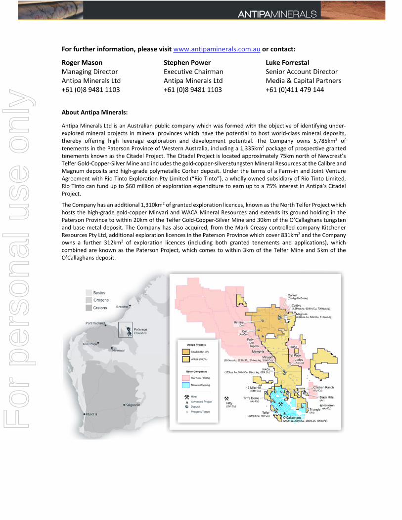
Antipa Minerals Ltd (ASX: AZY) (‘Antipa’, ‘the Company’) is pleased to announce the commencement of the 2018 drill programme at the Citadel Project (the “Project”) as part of the $60M farm‐in by Rio Tinto Exploration Pty Limited (‘Rio Tinto’), a wholly owned subsidiary of Rio Tinto Limited. The Citadel Project is located in the prospective Paterson Province, 80km north of Newcrest’s Telfer gold‐copper‐silver mine in northern Western Australia (Figure 1). Under the terms of the farm‐in agreement, Rio Tinto continues to operate the Citadel Project. Rio Tinto has proposed, subject to any changes which may be made consequent upon results, field conditions and ongoing review, a reverse circulation drill programme of up to 3,050m to test several intrusion related, with potential porphyry affinities, copper‐gold targets, including:
Folly: Hosted within the highly prospective El Paso Corridor (Figure 1) and supported by existing lithological, geochemical and geophysical data:
o Favourable lithology, including porphyritic‐granites in proximity to “reactive” carbonate sequences;
o Geochemical anomalies typical of mineralised intrusion related or porphyry systems, copper values up to 175ppm and 565ppm in soils and rock‐chips, respectively;
o Aerial electromagnetic (‘AEM’) conductivity and magnetic geophysical anomalies hosted within classic “doughnut” interpreted alteration halos surrounding felsic intrusions; and
o Shallow younger cover with areas of sub‐crop.
GT1: Located 15km northwest of Folly in a favourable geological and structural setting within the highly prospective El Paso Corridor. The GT1 target is supported by overlapping magnetic and AEM conductivity anomalies.
MB1: Located 10km northeast of Folly the available magnetic data supports a buried copper‐gold intrusion related or porphyry target.
Rio Tinto also continues to review the wider Citadel Project area including the Magnum Dome for the identification of new targets, activities include:
Compilation of all historic and current datasets (completed);
Re‐logging of Calibre and Magnum deposit diamond drill core (completed);
Generation of a Magnum Dome structural model (in progress); and
Definition of RC and/or diamond drilling targets (pending).
For
per
sona
l use
onl
y

Figure 1: Paterson Province magnetic plan showing the Citadel Project and proximal Antipa tenements
(“brighter” regions), the El Paso Corridor and deposit/prospect locations including Folly, GT1 and
MB1. NB: Over airborne magnetic image (Pseudo-colour First Vertical Derivative and typically a 50 to 100m flight-line
spacing at an altitude of 30m).
Farm-in Terms
The farm‐in agreement with Rio Tinto requires the following expenditure to be incurred (or paid) by Rio Tinto to earn up to a 75% joint venture interest in the Citadel Project:
$3 million exploration expenditure within 18 months of execution of the farm‐in agreement (execution date: 9 October 2015). This has now been satisfied. No joint venture interest was earned by the incurring of this amount.
$8 million exploration expenditure within a further 3 year period commencing 11 April 2017 to earn a 51% joint venture interest. Rio Tinto is in the second year of this stage.
$14 million exploration expenditure within a further 3 year period to earn a 65% joint venture interest. Antipa may elect to contribute at this point and maintain a 35% joint venture interest.
$35 million exploration expenditure within a further 3 year period to earn a 75% joint venture interest.
Rio Tinto has a right to withdraw from the farm‐in at the completion of each annual exploration programme.
For
per
sona
l use
onl
y
For further information, please visit www.antipaminerals.com.au or contact:
Roger Mason Managing Director Antipa Minerals Ltd +61 (0)8 9481 1103
Stephen Power Executive Chairman Antipa Minerals Ltd +61 (0)8 9481 1103
Luke Forrestal Senior Account Director Media & Capital Partners +61 (0)411 479 144
About Antipa Minerals:
Antipa Minerals Ltd is an Australian public company which was formed with the objective of identifying under‐explored mineral projects in mineral provinces which have the potential to host world‐class mineral deposits, thereby offering high leverage exploration and development potential. The Company owns 5,785km2 of tenements in the Paterson Province of Western Australia, including a 1,335km2 package of prospective granted tenements known as the Citadel Project. The Citadel Project is located approximately 75km north of Newcrest’s Telfer Gold‐Copper‐Silver Mine and includes the gold‐copper‐silver±tungsten Mineral Resources at the Calibre and Magnum deposits and high‐grade polymetallic Corker deposit. Under the terms of a Farm‐in and Joint Venture Agreement with Rio Tinto Exploration Pty Limited (“Rio Tinto”), a wholly owned subsidiary of Rio Tinto Limited, Rio Tinto can fund up to $60 million of exploration expenditure to earn up to a 75% interest in Antipa’s Citadel Project.
The Company has an additional 1,310km2 of granted exploration licences, known as the North Telfer Project which hosts the high‐grade gold‐copper Minyari and WACA Mineral Resources and extends its ground holding in the Paterson Province to within 20km of the Telfer Gold‐Copper‐Silver Mine and 30km of the O’Callaghans tungsten and base metal deposit. The Company has also acquired, from the Mark Creasy controlled company Kitchener Resources Pty Ltd, additional exploration licences in the Paterson Province which cover 831km2 and the Company owns a further 312km2 of exploration licences (including both granted tenements and applications), which combined are known as the Paterson Project, which comes to within 3km of the Telfer Mine and 5km of the O’Callaghans deposit.
For
per
sona
l use
onl
y

Competent Persons Statement – Exploration Results:
The information in this report that relates to the Exploration Results is based on and fairly represents information and supporting documentation compiled by Mr Roger Mason, a Competent Person who is a Member of The Australasian Institute of Mining and Metallurgy. Mr Mason is a full‐time employee of the Company. Mr Mason is the Managing Director of Antipa Minerals Limited, is a substantial shareholder of the Company and is an option holder of the Company. Mr Mason has sufficient experience relevant to the style of mineralisation and type of deposit under consideration and to the activity being undertaking to qualify as a Competent Person as defined in the 2012 Edition of the ‘Australasian Code for Reporting of Exploration Results, Mineral Resources and Ore Reserves’. Mr Mason consents to the inclusion in the report of the matters based on his information in the form and context in which it appears.
Various information in this report which relates to Citadel Project Exploration Results have been extracted from the following announcements:
Report entitled “Rio Tinto – Antipa Citadel Project Joint Venture” created on 9 October 2015;
Report entitled “Rio Tinto Elects to Proceed to Stage 2 of Citadel Farm‐In” created on 12 April 2017;
Report entitled “Citadel Project 2017 Exploration Programme Update” created on 8 November 2017;
Report entitled “Citadel Project 2018 Exploration Programme” created on 27 March 2018; and
Report entitled “Presentation – Diggers and Dealers Conference Revised” created on 6 August 2018.
All of which are available to view on www.antipaminerals.com.au and www.asx.com.au. The company confirms that it is not aware of any new information or data that materially affects the information included in the original market announcements.
Competent Persons Statement – Mineral Resource Estimations for the Minyari-WACA Deposits, Calibre Deposit and Magnum Deposit:
The information in this report that relates to relates to the estimation and reporting of the Minyari‐WACA deposits Mineral Resources is extracted from the report entitled “Minyari/WACA Deposits Maiden Mineral Resources” created on 16 November 2017, the Calibre deposit Mineral Resource information is extracted from the report entitled “Calibre Deposit Mineral Resource Update” created on 17 November 2017 and the Magnum deposit Mineral Resource information is extracted from the report entitled “Calibre and Magnum Deposit Mineral Resource JORC 2012 Updates” created on 23 February 2015, all of which are available to view on www.antipaminerals.com.au and www.asx.com.au. The Company confirms that it is not aware of any new information or data that materially affects the information included in the original market announcements. The Company confirms that the form and context in which the Competent Person’s findings are presented have not been materially modified from the original market announcements.
Forward-Looking Statements:
This document may include forward‐looking statements. Forward‐looking statements include, but are not limited to, statements concerning Antipa Mineral Ltd’s planned exploration programme and other statements that are not historical facts. When used in this document, the words such as "could," "plan," "estimate," "expect," "intend," "may," "potential," "should," and similar expressions are forward‐looking statements. Although Antipa Minerals Ltd believes that its expectations reflected in these forward‐looking statements are reasonable, such statements involve risks and uncertainties and no assurance can be given that actual results will be consistent with these forward‐looking statements.
For
per
sona
l use
onl
y
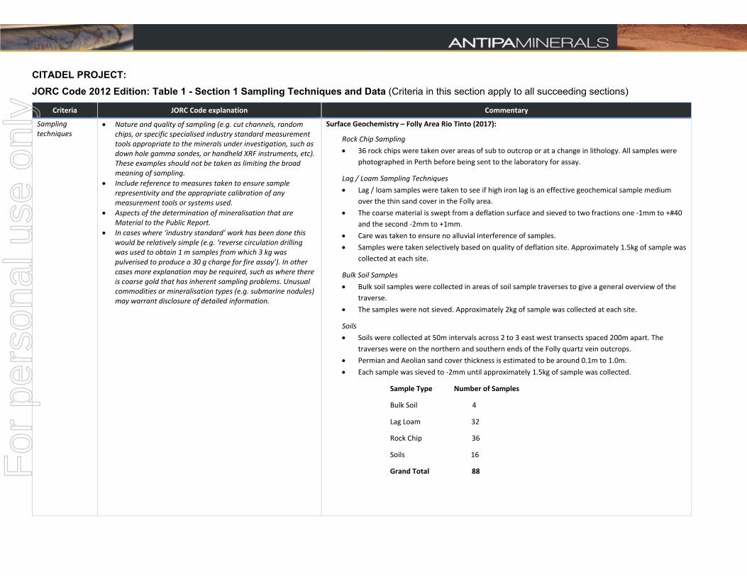
CITADEL PROJECT: JORC Code 2012 Edition: Table 1 - Section 1 Sampling Techniques and Data (Criteria in this section apply to all succeeding sections)
Criteria JORC Code explanation Commentary
Sampling techniques
Nature and quality of sampling (e.g. cut channels, random chips, or specific specialised industry standard measurement tools appropriate to the minerals under investigation, such as down hole gamma sondes, or handheld XRF instruments, etc). These examples should not be taken as limiting the broad meaning of sampling.
Include reference to measures taken to ensure sample representivity and the appropriate calibration of any measurement tools or systems used.
Aspects of the determination of mineralisation that are Material to the Public Report.
In cases where ‘industry standard’ work has been done this would be relatively simple (e.g. ‘reverse circulation drilling was used to obtain 1 m samples from which 3 kg was pulverised to produce a 30 g charge for fire assay’). In other cases more explanation may be required, such as where there is coarse gold that has inherent sampling problems. Unusual commodities or mineralisation types (e.g. submarine nodules) may warrant disclosure of detailed information.
Surface Geochemistry – Folly Area Rio Tinto (2017):
Rock Chip Sampling
36 rock chips were taken over areas of sub to outcrop or at a change in lithology. All samples were
photographed in Perth before being sent to the laboratory for assay.
Lag / Loam Sampling Techniques
Lag / loam samples were taken to see if high iron lag is an effective geochemical sample medium
over the thin sand cover in the Folly area.
The coarse material is swept from a deflation surface and sieved to two fractions one ‐1mm to +#40
and the second ‐2mm to +1mm.
Care was taken to ensure no alluvial interference of samples.
Samples were taken selectively based on quality of deflation site. Approximately 1.5kg of sample was
collected at each site.
Bulk Soil Samples
Bulk soil samples were collected in areas of soil sample traverses to give a general overview of the
traverse.
The samples were not sieved. Approximately 2kg of sample was collected at each site.
Soils
Soils were collected at 50m intervals across 2 to 3 east west transects spaced 200m apart. The
traverses were on the northern and southern ends of the Folly quartz vein outcrops.
Permian and Aeolian sand cover thickness is estimated to be around 0.1m to 1.0m.
Each sample was sieved to ‐2mm until approximately 1.5kg of sample was collected.
Sample Type Number of Samples
Bulk Soil 4
Lag Loam 32
Rock Chip 36
Soils 16
Grand Total 88
For
per
sona
l use
onl
y

Criteria JORC Code explanation Commentary
Surface Geochemistry – Folly Area “Chadwick” consortium:
Reference 1988 DMIRS Annual Report A24658 (available publicly online via DMIRS WAMEX portal).
Drill Results:
This release has no reference to previously unreported drill results.
Airborne Electromagnetic and Magnetic Survey – Rio Tinto / Antipa (2017):
Folly and MB1 magnetic anomalies and Folly EM conductivity anomaly:
An Airborne Electromagnetic and Magnetic Survey was undertaken in 2017 by New Resolution
Geophysics (NRG™), an independent geophysical contractor/service provider.
The survey employed the following equipment and sampling techniques:
Survey Type = Time Domain Airborne Electromagnetics and Magnetics:
Electromagnetic System
Type Xcite™
Weight ~450kg
Structure Fully inflatable frame
Aircraft Type AS350B Series
Engine Type Turbine
Fuel Type JetA1
Acquisition System
Type NRG RDAS II
CPU Dual Core ARM 1.5Ghz
Operation Temperature ‐10 to 65 Degrees C
Standard Sampling Rate 20 Hz (capable of >1kHz)
Magnetometer Counter
Type NRG RDAC ll
Internal System Noise <0.0001 nT
Adc Inputs 24
Magnetometer Inputs 4
Recording Rate 20 Hz (capable of >1kHz)
Magnetometer Sensor
Type Single Sensor Scintrex CS3
Measurement Range 15 000 – 105 000 nT
Gradient Tolerance 40 000 nT/m
For
per
sona
l use
onl
y
Criteria JORC Code explanation Commentary
Operating Temperature ‐40 to +50 Degrees C
Recording Rate 20 Hz (capable of >1kHz)
Xcite Geometry
Rx ‐Bird GPS
Horizontal offset [m] (GPS in front of Rx) 9.2
Vertical offset [m] (GPS higher than Rx) 0.5
Helicopter ‐ Mag Bird
Effective tow rope length in flight [m] 10
Tow rope angle with horizontal [deg] 60
Tow rope vertical [m] 8.66
Tow rope horizontal [m] 5.00
Helicopter ‐ Receiver
Effective tow rope length in flight [m] 28
Tow rope angle with horizontal [deg] 60
Tow rope vertical [m] 24.25
Tow rope horizontal [m] 14.00
Receiver (Z‐component)
Diameter [m] 1.00
Area [m^2] 0.79
Turns 100.00
Effective Area [m^2] 78.54
Receiver (X‐component)
Diameter [m] Not Round
Area [m^2] 0.13
Turns 200.00
Effective Area [m^2] 26.39
Bucking Coil
Diameter [m] 3.2
Area [m^2] 8.0
For
per
sona
l use
onl
y

Criteria JORC Code explanation Commentary
Turns 1.0
Effective Area [m^2] 8.0
Transmitter
Diameter [m] 18.4
Area [m^2] 265.9
Turns 4.0
Effective Area [m^2] 1063.6
Transmitter‐Receiver
Horizontal offset of centre [m] 0
Vertical offset of centre [m] (Tx below Rx) 0.5
Airborne Electromagnetic GEOTEM Survey ‐ BHP Minerals Pty Ltd (1996):
GT1 EM conductivity anomaly:
GEOTEM data reference 1997 DMIRS Annual Report A51334 (available publicly online
via DMIRS WAMEX portal).
Drilling techniques
Drill type (e.g. core, reverse circulation, open‐hole hammer, rotary air blast, auger, Bangka, sonic, etc) and details (e.g. core diameter, triple or standard tube, depth of diamond tails, face‐sampling bit or other type, whether core is oriented and if so, by what method, etc).
This release has no reference to previously unreported drill results.
Drill sample recovery
Method of recording and assessing core and chip sample recoveries and results assessed.
Measures taken to maximise sample recovery and ensure representative nature of the samples.
Whether a relationship exists between sample recovery and grade and whether sample bias may have occurred due to preferential loss/gain of fine/coarse material.
This release has no reference to previously unreported drill results.
Logging Whether core and chip samples have been geologically and geotechnically logged to a level of detail to support appropriate Mineral Resource estimation, mining studies and metallurgical studies.
Whether logging is qualitative or quantitative in nature. Core (or costean, channel, etc) photography.
The total length and percentage of the relevant intersections logged.
This release has no reference to previously unreported drill results.
Sub‐sampling techniques and
If core, whether cut or sawn and whether quarter, half or all core taken.
If non‐core, whether riffled, tube sampled, rotary split, etc and
This release has no reference to previously unreported drill results.
For
per
sona
l use
onl
y
Criteria JORC Code explanation Commentary
sample preparation
whether sampled wet or dry.
For all sample types, the nature, quality and appropriateness of the sample preparation technique.
Quality control procedures adopted for all sub‐sampling stages to maximise representivity of samples.
Measures taken to ensure that the sampling is representative of the in situ material collected, including for instance results for field duplicate/second‐half sampling.
Whether sample sizes are appropriate to the grain size of the material being sampled.
Quality of assay data and laboratory tests
The nature, quality and appropriateness of the assaying and laboratory procedures used and whether the technique is considered partial or total.
For geophysical tools, spectrometers, handheld XRF instruments, etc, the parameters used in determining the analysis including instrument make and model, reading times, calibrations factors applied and their derivation, etc.
Nature of quality control procedures adopted (e.g. standards, blanks, duplicates, external laboratory checks) and whether acceptable levels of accuracy (i.e. lack of bias) and precision have been established.
Surface Geochemistry – Folly Area Rio Tinto:
Sample preparation was completed at ALS Laboratory Group in Perth.
Best practice sample preparation involved oven drying, coarse crushing of the sample using a
primary crusher down to crushed size of approximately 70% passing 2mm, followed by pulverisation
of a rotary split 1kg aliquot to a grind size of approximately 85% passing 75 µm via a ring mill
pulveriser using a carbon steel ring set. The pulverised sample is then further split into a sub–
sample/s for analysis.
The 0.25 gram pulverised sub–samples were digested and refluxed with hydrofluoric, nitric,
hydrochloric and perchloric acids (“four acid digest”) suitable for silica based samples. This digest is
considered to approach a total dissolution for most minerals.
Analytical methods used were Inductively Coupled Plasma Atomic Emission Spectroscopy / Mass
Spectrometry (ICP–AES / ICP‐MS) for Ag, Al, As, Au, Ba, Be, Bi, Ca, Cd, Ce, Co, Cr, Cs, Cu, Fe, Ga, Ge,
Hf, In, K, La, Li, Mg, Mn, Mo, Na, Nb, Ni, P, Pb, Pd, Pt, Rb, Re, S, Sb, Sc, Sn, Sr, Ta, Te, Th, Ti, Tl, U, V,
W, Y, Zn and Zr.
Note that based on the analytical technique described above, the assay results for Au, Pd and Pt are
considered semi‐quantitative in nature and with the Au results being determined from only 0.25g of
material dissolved sample material they must be treated with caution. The Au, Pd and Pt data are
obtained by this method for the purposes of identifying low level geochemical anomalism.
A lead collection Fire Assay on a 50g sample with Inductively Coupled Plasma Atomic Absorption
Spectroscopy (ICP‐AAS) undertaken to determine gold content with a detection limit of 0.005ppm
(for selected mineralised samples).
Ore grade ICP‐AES analysis was completed on samples returning results above upper detection limit.
Surface Geochemistry – Folly Area “Chadwick” consortium:
Reference 1988 DMIRS Annual Report A24658 (available publicly online via DMIRS WAMEX portal).
Airborne Electromagnetic and Magnetic Survey – Folly and MB1 magnetic anomalies and Folly EM anomaly:
The Airborne Electromagnetic and Magnetic Survey was undertaken by New Resolution Geophysics
(NRG™), an independent geophysical contractor/service provider.
For
per
sona
l use
onl
y
Criteria JORC Code explanation Commentary
The AEM survey involved acquisition of airborne data at 300m line spacing, 60° heading from north.
A total of 1,150 line‐km was completed during the 2017 AEM survey.
A nominal survey altitude of 37m (Tx‐Rx array) and 61m (helicopter) was employed which was dependent on safety considerations and tree canopy height. A minimum line length of 3km was utilized for the flight path.
Review of the data can be summarised by:
Data quality was considered to be of high quality.
The pilot was of high Calibre with impressive line and height following.
No gaps “drop outs” were observed in any of the database fields.
Filtering of Raw data was minimal and very close to the final product.
Previously obtained aeromagnetic surveys involved acquisition of airborne data at 50 to 100m line
spacing, 60° heading from north.
Drill Results:
This release has no reference to previously unreported drill results.
Verification of sampling and assaying
The verification of significant intersections by either independent or alternative company personnel.
The use of twinned holes.
Documentation of primary data, data entry procedures, data verification, data storage (physical and electronic) protocols.
Discuss any adjustment to assay data.
2017 and 1988 Folly area surface geochemical sampling programmes:
The 2017 and 1988 Folly area surface sampling programmes were geochemical reconnaissance in
nature. These two generations of results showed significant compatibility, considered sufficient to
verify the various surface geochemical responses.
Drill Results:
This release has no reference to previously unreported drill results.
Location of data points
Accuracy and quality of surveys used to locate drill holes (collar and down‐hole surveys), trenches, mine workings and other locations used in Mineral Resource estimation.
Specification of the grid system used.
Quality and adequacy of topographic control.
km = kilometre; m = metre; mm = millimetre.
Novatel DL‐V3L1L2 with real time differential correction (12 satellites), 20 Hz recording rate was used
for GPS positioning.
The EM survey coordinates are in WGS84 UTM zone 51S coordinates.
This release has no reference to previously unreported drill results.
Data spacing and distribution
Data spacing for reporting of Exploration Results.
Whether the data spacing and distribution is sufficient to establish the degree of geological and grade continuity appropriate for the Mineral Resource and Ore Reserve estimation procedure(s) and classifications applied.
Whether sample compositing has been applied.
Drill Results:
This release has no reference to previously unreported drill results.
2017 and 1988 Folly area surface geochemical sampling programmes:
Data spacing etc as described under “Sampling Techniques” section above.
Airborne Electromagnetic and Magnetic Surveys – Folly and MB1 magnetic anomalies and Folly EM anomaly:
The AEM survey involved acquisition of airborne data at 300m line spacing, 60° heading from north.
For
per
sona
l use
onl
y
Criteria JORC Code explanation Commentary
Previously obtained aeromagnetic surveys involved acquisition of airborne data at 50 to 100m line
spacing, 60° heading from north.
Orientation of data in relation to geological structure
Whether the orientation of sampling achieves unbiased sampling of possible structures and the extent to which this is known, considering the deposit type.
If the relationship between the drilling orientation and the orientation of key mineralised structures is considered to have introduced a sampling bias, this should be assessed and reported if material.
Drill Results:
This release has no reference to previously unreported drill results.
2017 and 1988 Folly area surface geochemical sampling programmes:
Orientation of sampling etc as described under “Sampling Techniques” section above.
Sample security The measures taken to ensure sample security. 2017 and 1988 Folly area surface geochemical sampling programmes:
The 2017 and 1988 Folly area surface sampling programmes were geochemical reconnaissance in
nature and standard sample security procedures applied.
Drill Results:
This release has no reference to previously unreported drill results.
Audits or reviews The results of any audits or reviews of sampling techniques and data.
2017 and 1988 Folly area surface geochemical sampling programmes:
The 2017 and 1988 Folly area surface sampling programme results were audited by both Rio Tinto
and Antipa Minerals technical personnel.
Drill Results:
This release has no reference to previously unreported drill results.
Airborne Electromagnetic and Magnetic Survey – Folly and MB1 magnetic anomalies and Folly EM anomaly:
All digital Airborne Electromagnetic and Magnetic data was subjected to rigorous auditing and
vetting by the independent geophysical contractor/service provider and data manager NRG™.
CITADEL PROJECT AREA Section 2 – Reporting of Exploration Results (Criteria listed in the preceding section also apply to this section)
Criteria JORC Code explanation Commentary
Mineral tenement and land tenure status
Type, reference name/number, location and ownership including agreements or material issues with third parties such as joint ventures, partnerships, overriding royalties, native title interests, historical sites, wilderness or national park and environmental settings.
The security of the tenure held at the time of reporting along with any known impediments to obtaining a licence to operate in the area.
The Airborne Electromagnetic and Magnetic survey is located within Exploration Licenses E45/4561
and E45/2876.
Antipa currently has a 100% interest in all Citadel Project tenements, including E45/4561, and there
are no royalties on these tenements.
On 9 October 2015 Farm‐in and JV Agreements were executed between Antipa and Rio Tinto
Exploration Pty Limited (Rio Tinto).
E45/2876, E45/2877 and E45/4561 are contained completely within land where the Martu People
have been determined to hold Native Title rights. No historical or environmentally sensitive sites
For
per
sona
l use
onl
y
Criteria JORC Code explanation Commentary
have been identified in the area of work.
E45/2874, E45/2901, E45/4212, E45/4213 and E45/4214 are contained completely within land
where the Nyangumarta People have been determined to hold Native Title rights. No historical or
environmentally sensitive sites have been identified in the area of work.
The tenements are all in ‘good standing’ with the Western Australian DMIRS.
There are no known impediments exist, including to obtain a licence to operate in the area.
Exploration done by other parties
Acknowledgment and appraisal of exploration by other parties.
Prior to 1988 limited to no mineral exploration activities.
1988 consortium consisting of Chadwick Holdings Pty Ltd, Ballup Pty Ltd and North West Exploration
Plc conducted reconnaissance exploration over then tenement E45/658, specifically the region in the
southwest corner of current tenement E45/4561, including “The Folly” and “The Tor” prospects.
1991 to 1996 BHP Australia (BHP Mineral Pty Ltd) completed various regional airborne geophysical
surveys (e.g. aeromagnetics, radiometrics, GeoTEM, ground magnetics, surface EM), geochemical
Aircore and selected diamond drilling programmes across a significant area which covered the
Citadel Project. Whilst this era of exploration highlighted a number of areas as being variously
anomalous, BHP did not locate any basement (Proterozoic) precious or base metal mineralisation. In
1995 BHP Minerals completed an MMI‐A/MMI‐B soil programme over an area which was ultimately
found to be the region within which the Magnum deposit was located.
1997 to 2002 JV partners Croesus‐Gindalbie completed minor surface geophysical surveys (e.g.
electromagnetics) and various drilling programmes across parts of the Citadel Project (i.e. 17 x
Diamond, 10 x RC and 134 x Aircore drillholes) leading to the discovery of the Magnum Au‐Cu‐Ag
deposit, and its partial delineation, in 1998.
2002 to 2003 JV partners Teck Cominco and Croesus‐Gindalbie completed detailed aeromagnetic
and radiometric surveys over the entire Citadel Project, Pole‐Pole IP over 8 targets and limited
drilling (i.e. 4 x Diamond drillholes) within the Citadel Project.
2004 to 2005 JV partners NGM Resources and Croesus‐Gindalbie completed limited drilling (i.e. 3 x
Diamond drillholes) at selected Citadel Project prospects intersecting minor Au‐Cu‐Ag mineralisation
at the Colt prospect.
2006 to 2010 Glengarry Resources/Centaurus Metals undertook re‐processing of existing data and
re‐logging of some drillcore. No drilling or geophysical surveys were undertaken and so no new
exploration results were forthcoming.
2011 to 2015 Antipa Minerals Ltd exploration of the Citadel Project including both regional and
prospect/area scale geophysical surveys (i.e. VTEM, ground EM, DHEM, ground magnetics and
ground gravity) and geochemical surveys (i.e. MMI‐M™ and SGH™ soil programmes) and drilling
programmes (i.e. diamond and RC) resulting in two greenfield discoveries in 2012, i.e. Calibre and
Corker, and subsequent drilling programmes.
October 2015 to March 2017 Antipa Minerals Ltd operators under a Farm‐in Agreement executed on
the 9 October 2015 between Antipa and Rio Tinto Exploration Pty Limited (“Rio Tinto”), a wholly
For
per
sona
l use
onl
y
Criteria JORC Code explanation Commentary
owned subsidiary of Rio Tinto Limited. RC drilling at Calibre late 2015, and in 2016 an extensive IP
survey, a regional target RC drilling programme and single (deep) diamond drill hole were
completed.
April 2017 to August 2018 Rio Tinto operators under the Farm‐in Agreement (see above). Further
extensive IP survey (predominantly gradient array IP with some pole‐dipole IP) in the southeastern
portion of E45/2877, an Air Core drilling Programme in the central region (Rimfire area) of E45/2876,
an RC drilling programme in the central region (Rimfire area) of E45/2876 and also the central region
(Calibre deposit area) of E45/2877, Folly area reconnaissance mapping and surface geochemical
sampling, and an aerial electromagnetic survey primarily over E45/4561 were completed.
Geology Deposit type, geological setting and style of mineralisation. The geological setting is Paterson Province Proterozoic aged meta‐sediment hosted hydrothermal
shear, fault and strata/contact controlled precious and/or base metal mineralisation which is
typically sulphide bearing. The mineralisation in the region is interpreted to be felsic to intermediate
reduced to weakly oxidized intrusion related (i.e. granite ± porphyry). The Paterson is a low grade
metamorphic terrane but local hydrothermal alteration and/or contact metamorphic mineral
assemblages and styles are indicative of a high‐temperature local environment. Mineralisation styles
include vein, stockwork, breccia and skarns.
Drill hole Information
A summary of all information material to the understanding of the exploration results including a tabulation of the following information for all Material drill holes:
easting and northing of the drill hole collar
elevation or RL (Reduced Level – elevation above sea level in metres) of the drill hole collar
dip and azimuth of the hole
down hole length and interception depth
hole length.
If the exclusion of this information is justified on the basis that the information is not Material and this exclusion does not detract from the understanding of the report, the Competent Person should clearly explain why this is the case.
This release has no reference to previously unreported drill results.
Data aggregation methods
In reporting Exploration Results, weighting averaging techniques, maximum and/or minimum grade truncations (e.g. cutting of high grades) and cut‐off grades are usually Material and should be stated.
Where aggregate intercepts incorporate short lengths of high grade results and longer lengths of low grade results, the procedure used for such aggregation should be stated and some typical examples of such aggregations should be shown in detail.
The assumptions used for any reporting of metal equivalent values should be clearly stated.
This release has no reference to previously unreported drill results, sampling, assays or
mineralisation.
For
per
sona
l use
onl
y
Criteria JORC Code explanation Commentary
Relationship between mineralisation widths and intercept lengths
These relationships are particularly important in the reporting of Exploration Results.
If the geometry of the mineralisation with respect to the drill hole angle is known, its nature should be reported.
If it is not known and only the down hole lengths are reported, there should be a clear statement to this effect (e.g. ‘down hole length, true width not known’).
This release has no reference to previously unreported drill results, sampling, assays or
mineralisation.
Diagrams Appropriate maps and sections (with scales) and tabulations of intercepts should be included for any significant discovery being reported These should include, but not be limited to a plan view of drill hole collar locations and appropriate sectional views.
All appropriate maps (with scales) and tabulations of survey parameters are reported.
This release has no reference to previously unreported drill results, sampling, assays or
mineralisation.
Balanced reporting
Where comprehensive reporting of all Exploration Results is not practicable, representative reporting of both low and high grades and/or widths should be practiced to avoid misleading reporting of Exploration Results.
The Company believes that the ASX announcement is a balanced report with all material results
reported.
Additional significant results can be found in previous public reports.
Other substantive exploration data
Other exploration data, if meaningful and material, should be reported including (but not limited to): geological observations; geophysical survey results; geochemical survey results; bulk samples – size and method of treatment; metallurgical test results; bulk density, groundwater, geotechnical and rock characteristics; potential deleterious or contaminating substances.
This announcement refers to previous exploration results including geophysics, drill results and
geology which can be found in previous public reports.
Further work The nature and scale of planned further work (e.g. tests for lateral extensions or depth extensions or large‐scale step‐out drilling).
Diagrams clearly highlighting the areas of possible extensions, including the main geological interpretations and future drilling areas, provided this information is not commercially sensitive.
Geophysical (± geochemical) anomalies identified by the 2017 Airborne Electromagnetic and
Magnetic survey are currently planned to be the subject of further investigation and evaluation via a
Reverse‐circulation (RC) drilling programme.
Relevant diagrams can be found in the attached report or in previous public reports.
For
per
sona
l use
onl
y