Embed Size (px)
Citation preview
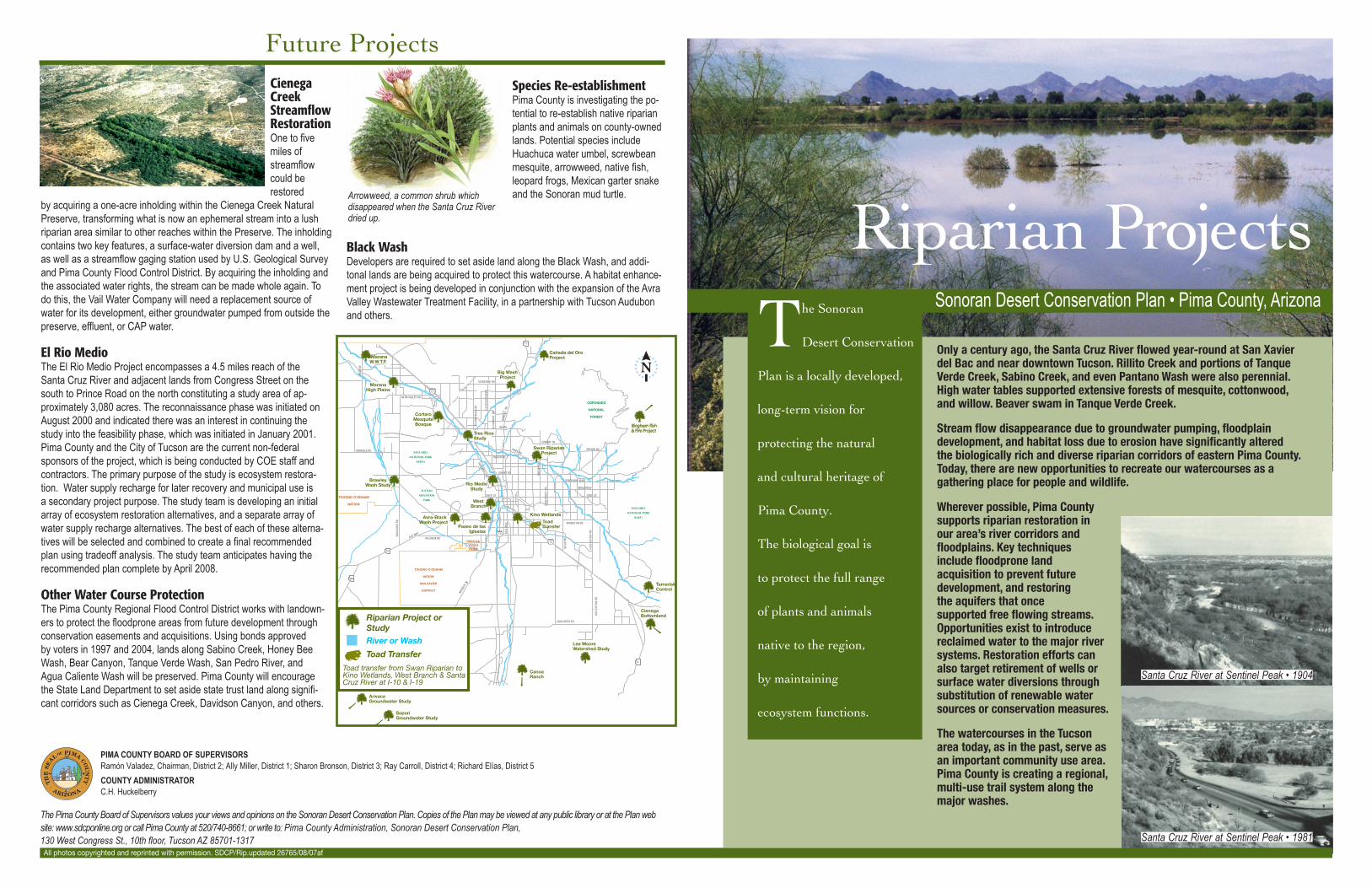
Riparian Projects
Santa Cruz River at Sentinel Peak • 1981
The Sonoran
Desert Conservation
Plan is a locally developed,
long-term vision for
protecting the natural
and cultural heritage of
Pima County.
The biological goal is
to protect the full range
of plants and animals
native to the region,
by maintaining
ecosystem functions.
Sonoran Desert Conservation Plan • Pima County, Arizona
Santa Cruz River at Sentinel Peak • 1904
Wherever possible, Pima County supports riparian restoration in our area’s river corridors and floodplains. Key techniques include floodprone land acquisition to prevent future development, and restoring the aquifers that once supported free flowing streams. Opportunities exist to introduce reclaimed water to the major river systems. Restoration efforts can also target retirement of wells or surface water diversions through substitution of renewable water sources or conservation measures.
The watercourses in the Tucson area today, as in the past, serve as an important community use area. Pima County is creating a regional, multi-use trail system along the major washes.
Only a century ago, the Santa Cruz River flowed year-round at San Xavier del Bac and near downtown Tucson. Rillito Creek and portions of Tanque Verde Creek, Sabino Creek, and even Pantano Wash were also perennial. High water tables supported extensive forests of mesquite, cottonwood, and willow. Beaver swam in Tanque Verde Creek.
Stream flow disappearance due to groundwater pumping, floodplain development, and habitat loss due to erosion have significantly altered the biologically rich and diverse riparian corridors of eastern Pima County. Today, there are new opportunities to recreate our watercourses as a gathering place for people and wildlife.
Species Re-establishmentPima County is investigating the po-tential to re-establish native riparian plants and animals on county-owned lands. Potential species include Huachuca water umbel, screwbean mesquite, arrowweed, native fish, leopard frogs, Mexican garter snake and the Sonoran mud turtle.
Black WashDevelopers are required to set aside land along the Black Wash, and addi-tonal lands are being acquired to protect this watercourse. A habitat enhance-ment project is being developed in conjunction with the expansion of the Avra Valley Wastewater Treatment Facility, in a partnership with Tucson Audubon and others.
Future Projects
PIMA COUNTY BOARD OF SUPERVISORSRamón Valadez, Chairman, District 2; Ally Miller, District 1; Sharon Bronson, District 3; Ray Carroll, District 4; Richard Elías, District 5
COUNTY ADMINISTRATOR C.H. Huckelberry
The Pima County Board of Supervisors values your views and opinions on the Sonoran Desert Conservation Plan. Copies of the Plan may be viewed at any public library or at the Plan web site: www.sdcponline.org or call Pima County at 520/740-8661; or write to: Pima County Administration, Sonoran Desert Conservation Plan, 130 West Congress St., 10th floor, Tucson AZ 85701-1317
Cienega Creek Streamflow RestorationOne to five miles of streamflow could be restored
by acquiring a one-acre inholding within the Cienega Creek Natural Preserve, transforming what is now an ephemeral stream into a lush riparian area similar to other reaches within the Preserve. The inholding contains two key features, a surface-water diversion dam and a well, as well as a streamflow gaging station used by U.S. Geological Survey and Pima County Flood Control District. By acquiring the inholding and the associated water rights, the stream can be made whole again. To do this, the Vail Water Company will need a replacement source of water for its development, either groundwater pumped from outside the preserve, effluent, or CAP water.
El Rio MedioThe El Rio Medio Project encompasses a 4.5 miles reach of the Santa Cruz River and adjacent lands from Congress Street on the south to Prince Road on the north constituting a study area of ap-proximately 3,080 acres. The reconnaissance phase was initiated on August 2000 and indicated there was an interest in continuing the study into the feasibility phase, which was initiated in January 2001. Pima County and the City of Tucson are the current non-federal sponsors of the project, which is being conducted by COE staff and contractors. The primary purpose of the study is ecosystem restora-tion. Water supply recharge for later recovery and municipal use is a secondary project purpose. The study team is developing an initial array of ecosystem restoration alternatives, and a separate array of water supply recharge alternatives. The best of each of these alterna-tives will be selected and combined to create a final recommended plan using tradeoff analysis. The study team anticipates having the recommended plan complete by April 2008.
Other Water Course ProtectionThe Pima County Regional Flood Control District works with landown-ers to protect the floodprone areas from future development through conservation easements and acquisitions. Using bonds approved by voters in 1997 and 2004, lands along Sabino Creek, Honey Bee Wash, Bear Canyon, Tanque Verde Wash, San Pedro River, and Agua Caliente Wash will be preserved. Pima County will encourage the State Land Department to set aside state trust land along signifi-cant corridors such as Cienega Creek, Davidson Canyon, and others.
All photos copyrighted and reprinted with permission. SDCP/Rip.updated 26765/08/07af
Arrowweed, a common shrub which disappeared when the Santa Cruz River dried up.
86
286286
19
10
83
10
77
AV RA VALLEY RD
TRI
OCDR
INA RD
SNYDER RD
SUNRISE DR
MANVILLE RD
22N D ST
6T
H A
EV
VA LENCIA RD
SAN
DA
RIO
RD
TH
GU
OH
DR N
O
SAHU ARITA RD
RIVER RD
AJO WAY
SPEED WAY BLVD
IRVINGT ON RD
BROA DW AY
22ND . ST.
WSN
AD
R
RC
AYDR TF
ORC
K BL
OD
R TH
GU
OH
DR N
O.
GRANT RD
RO GER RD
SILVERBELL RD
ORA
CLE
RD
AL
AD
AN
ACR
D
AL
LLO
HCLB
ADV
.
DR ELA
DYNR
OHT
MIS
SION RD
TOHONO O’ODHAM
NATION
SAN XAVIER
DISTRICT
TOHONO O’ODHAM
NATION
PASCUAYAQUITRIBE
SAGUARO
NATIONAL PARK
(WEST)
TUCSON
MOUNTAIN
PARK
CORONADO
NATIONAL
FOREST
SAGUARO
NATIONAL PARK
(EAST)
River or Wash
Toad transfer from Swan Riparian to Kino Wetlands, West Branch & Santa Cruz River at I-10 & I-19
Paseo de lasIglesias
Kino Wetlands
Swan RiparianProject
Tres RiosStudy
CortaroMesquiteBosque
Riparian Project or Study
CienegaBottomland
CanoaRanch
TA NGERINE RD
MaranaW.W.T.F.
Arivaca Groundwater Study
SoporiGroundwater Study
ToadTransfer
TamariskControl
MaranaHigh Plains
Rio MedioStudy
WestBranch
Avra-Black Wash Project
Cañada del OroProject
Big WashProject
BrawleyWash Study
Toad TransferLee Moore Watershed Study
Bingham Fish& Fire Project
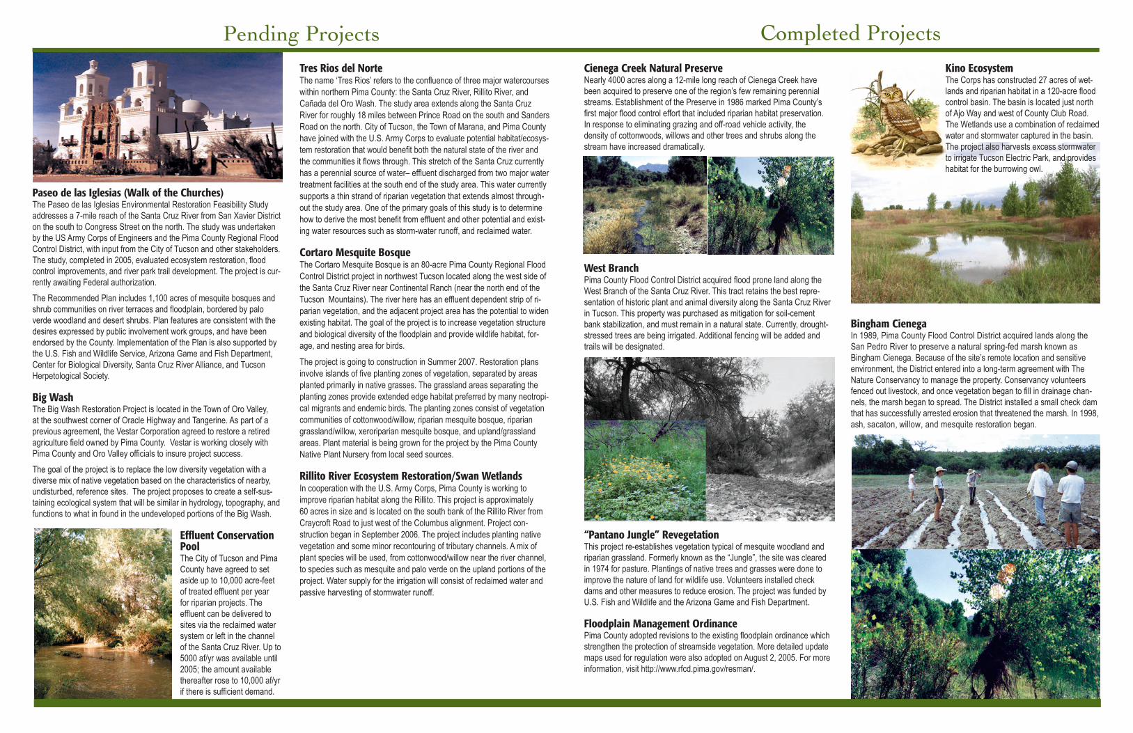
Kino EcosystemThe Corps has constructed 27 acres of wet-lands and riparian habitat in a 120-acre flood control basin. The basin is located just north of Ajo Way and west of County Club Road. The Wetlands use a combination of reclaimed water and stormwater captured in the basin. The project also harvests excess stormwater to irrigate Tucson Electric Park, and provides habitat for the burrowing owl.
Bingham CienegaIn 1989, Pima County Flood Control District acquired lands along the San Pedro River to preserve a natural spring-fed marsh known as Bingham Cienega. Because of the site’s remote location and sensitive environment, the District entered into a long-term agreement with The Nature Conservancy to manage the property. Conservancy volunteers fenced out livestock, and once vegetation began to fill in drainage chan-nels, the marsh began to spread. The District installed a small check dam that has successfully arrested erosion that threatened the marsh. In 1998, ash, sacaton, willow, and mesquite restoration began.
Pending Projects
Paseo de las Iglesias (Walk of the Churches)The Paseo de las Iglesias Environmental Restoration Feasibility Study addresses a 7-mile reach of the Santa Cruz River from San Xavier District on the south to Congress Street on the north. The study was undertaken by the US Army Corps of Engineers and the Pima County Regional Flood Control District, with input from the City of Tucson and other stakeholders. The study, completed in 2005, evaluated ecosystem restoration, flood control improvements, and river park trail development. The project is cur-rently awaiting Federal authorization.
The Recommended Plan includes 1,100 acres of mesquite bosques and shrub communities on river terraces and floodplain, bordered by palo verde woodland and desert shrubs. Plan features are consistent with the desires expressed by public involvement work groups, and have been endorsed by the County. Implementation of the Plan is also supported by the U.S. Fish and Wildlife Service, Arizona Game and Fish Department, Center for Biological Diversity, Santa Cruz River Alliance, and Tucson Herpetological Society.
Big Wash The Big Wash Restoration Project is located in the Town of Oro Valley, at the southwest corner of Oracle Highway and Tangerine. As part of a previous agreement, the Vestar Corporation agreed to restore a retired agriculture field owned by Pima County. Vestar is working closely with Pima County and Oro Valley officials to insure project success.
The goal of the project is to replace the low diversity vegetation with a diverse mix of native vegetation based on the characteristics of nearby, undisturbed, reference sites. The project proposes to create a self-sus-taining ecological system that will be similar in hydrology, topography, and functions to what in found in the undeveloped portions of the Big Wash.
Effluent Conservation Pool The City of Tucson and Pima County have agreed to set aside up to 10,000 acre-feet of treated effluent per year for riparian projects. The effluent can be delivered to sites via the reclaimed water system or left in the channel of the Santa Cruz River. Up to 5000 af/yr was available until 2005; the amount available thereafter rose to 10,000 af/yr if there is sufficient demand.
Tres Rios del NorteThe name ‘Tres Rios’ refers to the confluence of three major watercourses within northern Pima County: the Santa Cruz River, Rillito River, and Cañada del Oro Wash. The study area extends along the Santa Cruz River for roughly 18 miles between Prince Road on the south and Sanders Road on the north. City of Tucson, the Town of Marana, and Pima County have joined with the U.S. Army Corps to evaluate potential habitat/ecosys-tem restoration that would benefit both the natural state of the river and the communities it flows through. This stretch of the Santa Cruz currently has a perennial source of water– effluent discharged from two major water treatment facilities at the south end of the study area. This water currently supports a thin strand of riparian vegetation that extends almost through-out the study area. One of the primary goals of this study is to determine how to derive the most benefit from effluent and other potential and exist-ing water resources such as storm-water runoff, and reclaimed water.
Cortaro Mesquite BosqueThe Cortaro Mesquite Bosque is an 80-acre Pima County Regional Flood Control District project in northwest Tucson located along the west side of the Santa Cruz River near Continental Ranch (near the north end of the Tucson Mountains). The river here has an effluent dependent strip of ri-parian vegetation, and the adjacent project area has the potential to widen existing habitat. The goal of the project is to increase vegetation structure and biological diversity of the floodplain and provide wildlife habitat, for-age, and nesting area for birds.
The project is going to construction in Summer 2007. Restoration plans involve islands of five planting zones of vegetation, separated by areas planted primarily in native grasses. The grassland areas separating the planting zones provide extended edge habitat preferred by many neotropi-cal migrants and endemic birds. The planting zones consist of vegetation communities of cottonwood/willow, riparian mesquite bosque, riparian grassland/willow, xeroriparian mesquite bosque, and upland/grassland areas. Plant material is being grown for the project by the Pima County Native Plant Nursery from local seed sources.
Rillito River Ecosystem Restoration/Swan WetlandsIn cooperation with the U.S. Army Corps, Pima County is working to improve riparian habitat along the Rillito. This project is approximately 60 acres in size and is located on the south bank of the Rillito River from Craycroft Road to just west of the Columbus alignment. Project con-struction began in September 2006. The project includes planting native vegetation and some minor recontouring of tributary channels. A mix of plant species will be used, from cottonwood/willow near the river channel, to species such as mesquite and palo verde on the upland portions of the project. Water supply for the irrigation will consist of reclaimed water and passive harvesting of stormwater runoff.
Completed Projects
Cienega Creek Natural PreserveNearly 4000 acres along a 12-mile long reach of Cienega Creek have been acquired to preserve one of the region’s few remaining perennial streams. Establishment of the Preserve in 1986 marked Pima County’s first major flood control effort that included riparian habitat preservation. In response to eliminating grazing and off-road vehicle activity, the density of cottonwoods, willows and other trees and shrubs along the stream have increased dramatically.
West BranchPima County Flood Control District acquired flood prone land along the West Branch of the Santa Cruz River. This tract retains the best repre-sentation of historic plant and animal diversity along the Santa Cruz River in Tucson. This property was purchased as mitigation for soil-cement bank stabilization, and must remain in a natural state. Currently, drought-stressed trees are being irrigated. Additional fencing will be added and trails will be designated.
“Pantano Jungle” RevegetationThis project re-establishes vegetation typical of mesquite woodland and riparian grassland. Formerly known as the “Jungle”, the site was cleared in 1974 for pasture. Plantings of native trees and grasses were done to improve the nature of land for wildlife use. Volunteers installed check dams and other measures to reduce erosion. The project was funded by U.S. Fish and Wildlife and the Arizona Game and Fish Department.
Floodplain Management OrdinancePima County adopted revisions to the existing floodplain ordinance which strengthen the protection of streamside vegetation. More detailed update maps used for regulation were also adopted on August 2, 2005. For more information, visit http://www.rfcd.pima.gov/resman/.