Embed Size (px)
Citation preview
4/5/2012
1
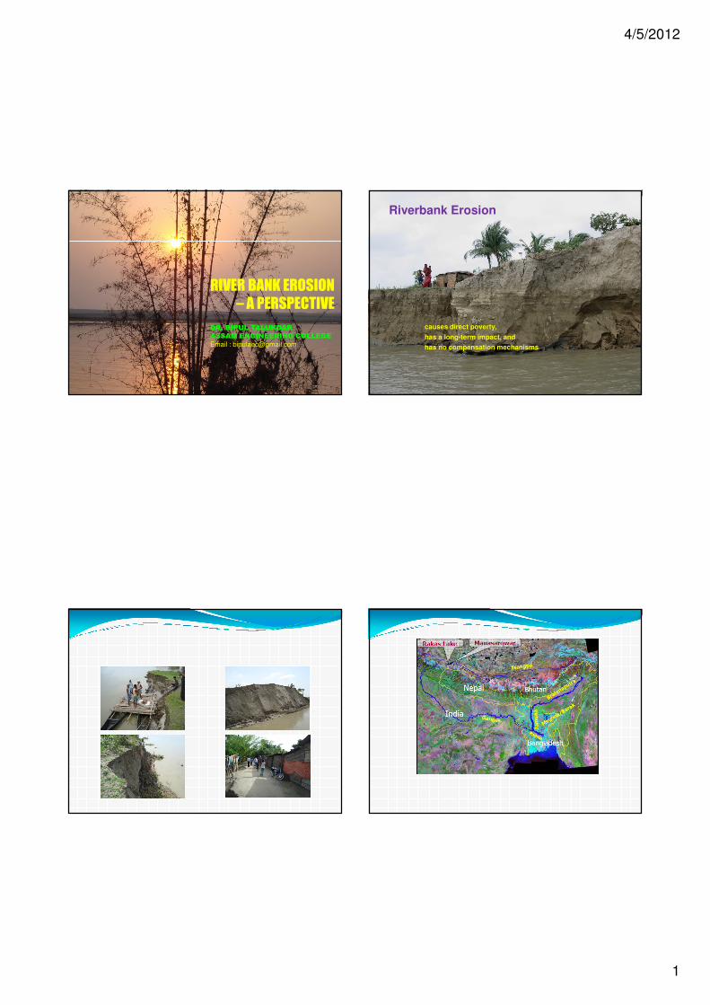
RIVER BANK EROSION
– A PERSPECTIVE
DR. BIPUL TALUKDAR
ASSAM ENGINEERING COLLEGE
Email : [email protected]
causes direct poverty,
has a long-term impact, and
has no compensation mechanisms
Riverbank Erosion
4/5/2012
2
Brahmaputra Basin
Erosion
Since 1954
Total area eroded = 4,25,900 Ha. (7%)
Rate of erosion = 8,500 Ha./Year
No. of villages eroded = 4521 nopopulation affected = 9,00,000
Affected ReachesModerate to Severe = 130Most Severe = 25
Oil Installations/Tea Gardens/ Important Towns and Cities/ Heritage Sites = 18.
Typical Erosion Phenomenon
In BRAHMAPUTRA
Brahmaputra is widening at an Alarming
Rate
1. First survey (1912-28): area: 3,870 km²
2. Second survey (1963-75): area: 4,850 km²
3. Third survey (2006 NESAC): area: 6,080 km²
Indications
The river area increased by around 50% by the way of erosion
The annual average loss of land is nearly 8500 ha
4/5/2012
3
SegmentSegmentSegmentSegment
Within Within Within Within
LongitudeLongitudeLongitudeLongitude
Total Erosion and Fill from 1912Total Erosion and Fill from 1912Total Erosion and Fill from 1912Total Erosion and Fill from 1912----28 to 199628 to 199628 to 199628 to 1996North BankNorth BankNorth BankNorth Bank South BankSouth BankSouth BankSouth Bank Total erosion & Fill on both the Total erosion & Fill on both the Total erosion & Fill on both the Total erosion & Fill on both the
BanksBanksBanksBanks
Erosion(E) Erosion(E) Erosion(E) Erosion(E)
(km(km(km(km2222))))
Fill(F) Fill(F) Fill(F) Fill(F)
(km(km(km(km2222))))
Net Effect Net Effect Net Effect Net Effect
(km(km(km(km2222))))
Erosion(E) Erosion(E) Erosion(E) Erosion(E)
(km(km(km(km2222))))
Fill(F) Fill(F) Fill(F) Fill(F)
(km(km(km(km2222))))
Net Effect Net Effect Net Effect Net Effect
(km(km(km(km2222))))
Erosion(E) Erosion(E) Erosion(E) Erosion(E)
(km(km(km(km2222))))
Fill(F) Fill(F) Fill(F) Fill(F)
(km(km(km(km2222))))
Net Net Net Net
Effect Effect Effect Effect
(km(km(km(km2222))))
95040’-95000’ 80.66 49.39 31.27 212.15 5.30 206.85 292.81 54.69 238.12
95000’-94000’ 254.5 118.58 135.92 138.54 84.06 54.48 393.04 202.64 190.4
94000’-93000’ 311.71 50.50 261.21 183.65 203.63 19.98 495.36 254.13 241.23
93000’-92000’ 142.28 195.43 53.15 208.11 260.51 52.40 350.39 455.94 105.55
92000’-91000’ 184.14 167.86 16.28 176.33 56.90 119.43 360.47 224.76 135.71
91000’-90000’ 268.71 277.16 8.44 197.8 21.45 176.35 466.51 298.61 167.9
Total 1242.00 858.92 383.08 1116.58 631.85 484.73 2358.58 1490.77 867.81
(Source : The Morphology of the Brahmaputra in Assam by J. N. Sharma)
Probable Causes of Erosion� River Instability Soil Erosion, Sediment
Transport and Deposition
� Himalayan mountain slopes shed large quantities of sediment (i) intense monsoon rainfall
(ii) high tectonic activities
(iii) soil conditions and
(iv) human intervention
� Steep slope of river Brahmaputra as well as all north bank tributaries
4/5/2012
4
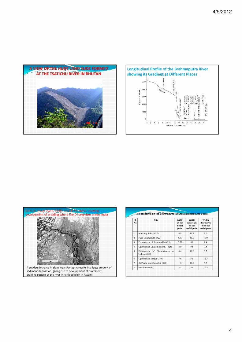
A VIEW OF THE HUGE LAND SLIDE FORMED
AT THE TSATICHU RIVER IN BHUTANLongitudinal Profile of the Brahmaputra River
showing its Gradient at Different Places
Landsat image (April, 1988) around Passighat showing
development of braiding where the Dihang river enters India
A sudden decrease in slope near Passighat results in a large amount of
sediment deposition, giving rise to development of prominent
braiding pattern of the river in its flood plain in Assam.
Sl.
No
.
Site Width
at the
nodal
point
Width
upstream
of the
nodal point
Width
downstrea
m of the
nodal point
1. Murkong Selek (627) 4.8 11.7 9.6
2. Near Disangmukh (522) 5.10 11.0 10.0
3. Downstream of Jhanzimukh (495) 3.75 8.0 8.4
4. Upstream of Dhansiri (North) (425) 4.0 9.6 7.5
5. Downstream of Dhansirimukh at
Galmiri (420)
4.4 11.0 5.2
6. Upstream of Tezpur (335) 3.6 5.5 12.3
7. At Pandu near Guwahati (198) 1.2 11.0 7.5
8. Pancharatna (85) 2.4 8.0 10.5
Nodal points on the Brahmaputra (Source : Brahmaputra Board)

4/5/2012
5
Satellite image of the river Brahmaputra (2008) just downstream of Guwahati
City indicating intense braiding. Width of the river at Pandu (near Guwahati) is 1.2 km but in down stream it is about 18 km.
Bed Level Variation in Alluvial Streams
Modes of Bank Erosion
Sediment gets into the river not only from the catchment area but is also contributed by erosion of its banks. Cause of failure of river banks can be any of the following singly or in combination.
1) Underwater erosion along the toe of bank during the falling stage of the river.
2) Direct erosion of the river bank.3) Sloughing of saturated bank caused by rapid drawdown.4) Liquefaction of saturated silty and sandy bank material.5) Erosion due to seepage from banks at low river discharge.6) Scour along waterline due to wind or wave wash of passing
vessels. Failures under 1, 3, 4 and 5 depend more on the properties of the bank
material than direct erosive action of stream flow.
� Sediment Transported by Brahmaputra has two main sources :
1. Soil Erosion (Man made)
2. Mass wasting (mostly not man made)
4/5/2012
6
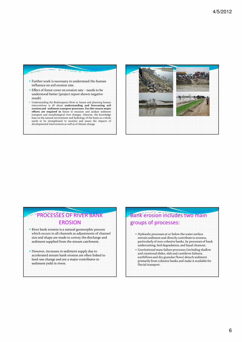
� Further work is necessary to understand the human influence on soil erosion rate.
� Effect of forest cover on erosion rate – needs to be understood better (project report shown negative result)
� Understanding the Brahmaputra River in Assam and planning humaninterventions is all about understanding and forecasting soilerosion and sediment transport processes. For this reason majorefforts are required in future to measure and analyse sedimenttransport and morphological river changes. Likewise, the knowledgebase on the natural environment and hydrology of the basin as a wholeneeds to be strengthened to monitor and assess the impacts ofdevelopmental interventions as well as of climate change.
PROCESSES OF RIVER BANK
EROSION� River bank erosion is a natural geomorphic process
which occurs in all channels as adjustments of channel size and shape are made to convey the discharge and sediment supplied from the stream catchment.
� However, increases in sediment supply due to accelerated stream bank erosion are often linked to land-use change and are a major contributor to sediment yield in rivers.
Bank erosion includes two main
groups of processes:
� Hydraulic processes at or below the water surface entrain sediment and directly contribute to erosion, particularly of non-cohesive banks, by processes of bank undercutting, bed degradation, and basal cleanout.
� Gravitational mass failure processes (including shallow and rotational slides, slab and cantilever failures, earthflows and dry granular flows) detach sediment primarily from cohesive banks and make it available for fluvial transport.
4/5/2012
7
� Identification of bank erosion processes is important for determining suitable measurement techniques and for choosing appropriate remedial options.
�The conditions under which different processes occur are determined by bank material characteristics and local soil moisture conditions (O’Neill and Kuhns 1994).
GRAVITATIONAL FAILURE MECHANISMS
� Shallow Slides
� These are shallow failures where a layer of material moves along a plane parallel to the bank surface. They are typical of soils with low cohesion, and occur when the angle of the bank exceeds the angle of internal friction of the bank material. Typically they occur where banks are moderately steep.

4/5/2012
8
Rotational failures
� Rotational failures are deep-seated movements of material both downward and outward along a curved slip surface and are common on cohesive banks with slopes less than 60°.
� commonly a result of scour at the base of the bank and/or high pore water pressure within the bank material.
� Often they will occur during rapid drawdown following high flow events.
Slab failure� Slab failures are the sliding and
forward toppling of a deep-seated mass into the channel.
� They are associated with steep, low height, fine-grained cohesive banks and tend to occur during lower flow conditions.
� They result from the combination of scour at the bank toe, high pore water pressure in the bank material and the development of tension cracks at the top of the bank.
Cantilever failure
� Cantilever failures are the collapse of an overhanging block into the channel, often occurring after the bank has been undercut. They tend to occur in a composite of fine/coarse grained materials, and to be active during low flow conditions.
Wet earthflow
� This type of failure occurs where the loss of strength of a section of bank due to saturation increases bank weight and decreases bank material strength to a point where the soil flows as a highly viscous liquid. Failures typically occur on low angle banks and the affected material flows down the bank to form lobes of material at the toe.
4/5/2012
9
Popout failure� Popout failure is a term used to
describe failures where small to medium sized blocks are forced out at or near the base of the river bank due to excessive pore-water pressure and overburden. A slab of material in the lower half of the bank will fall out, leaving an alcove-shaped cavity.
� This mode of failure is usually associated with steep banks and saturated finer-grained cohesive bank materials that allow the build up of positive pore-water pressure and/or strong seepage within its structure.
Dry granular flow
� This type of failure typically occurs on non-cohesive banks at, or close to, the angle of repose, which are undercut, thereby increasing the local bank angle above the friction angle. Individual grains roll, slide and bounce down the bank in a layer, a few grains thick. Usually there is a toe accumulation of loose grains in cones and fans.
Soil/rockfall� This only occurs on weakly-cohesive steep eroding
banks where individual grains or blocks of soil fall directly into the channel (Thorne 1998). They often occur when a stream undercuts the toe of a sand, gravel, or deeply weathered rock bank.
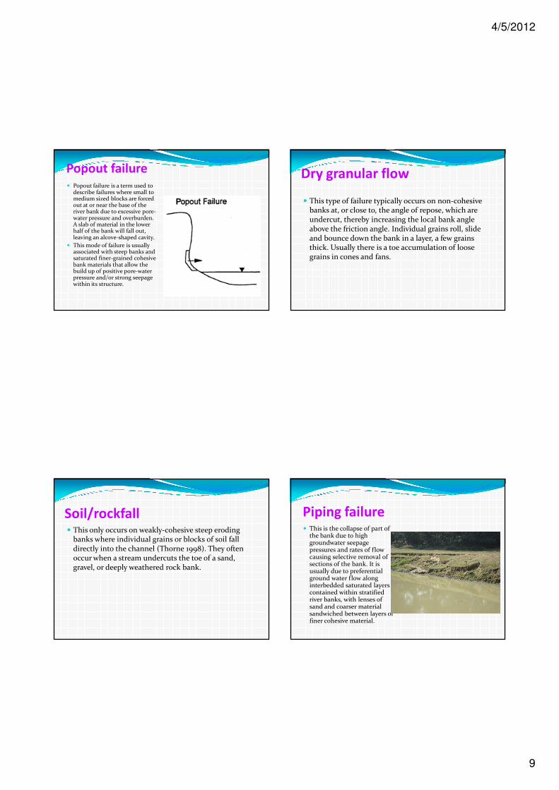
Piping failure� This is the collapse of part of
the bank due to high groundwater seepage pressures and rates of flow causing selective removal of sections of the bank. It is usually due to preferential ground water flow along interbedded saturated layers contained within stratified river banks, with lenses of sand and coarser material sandwiched between layers of finer cohesive material.
4/5/2012
10
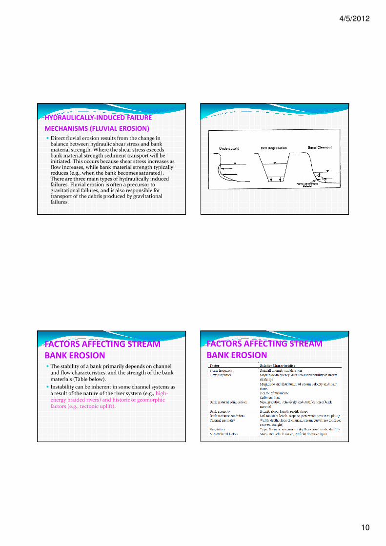
HYDRAULICALLY-INDUCED FAILURE
MECHANISMS (FLUVIAL EROSION)
� Direct fluvial erosion results from the change in balance between hydraulic shear stress and bank material strength. Where the shear stress exceeds bank material strength sediment transport will be initiated. This occurs because shear stress increases as flow increases, while bank material strength typically reduces (e.g., when the bank becomes saturated). There are three main types of hydraulically induced failures. Fluvial erosion is often a precursor to gravitational failures, and is also responsible for transport of the debris produced by gravitational failures.
FACTORS AFFECTING STREAM
BANK EROSION� The stability of a bank primarily depends on channel
and flow characteristics, and the strength of the bank materials (Table below).
� Instability can be inherent in some channel systems as a result of the nature of the river system (e.g., high-energy braided rivers) and historic or geomorphic factors (e.g., tectonic uplift).
FACTORS AFFECTING STREAM
BANK EROSION
4/5/2012
11
Conclusion� The Brahmaputra river is the main cause of erosion
and flooding in Assam. The combination of twoextreme processes – tectonics and monsoon rainfallcauses great river instability.
� Lot more short term and piece wise works have beendone for flood and erosion management. No long termstrategy has been planned till now.
� Erosion needs to be addressed first to sustain floodprotection works.
� Two types of action plan are needed : immediate &long.
Contd.� Development of erosion prediction, flood forecasting,
flood plain zoning, quality data acquisition, regionaland international co-operation, research tounderstand the river system come under immediateactions to be done.
� Before implementation, long term strategies need indepth studies.
References:
1. “The morphology of the Brahmaputra river”, Proceedingsof the morphology workshop, IEI Guwahati, 19-20 Nov.,2007.
2. Garde, R.J. and Rangaraju, K.G., “Mechanics of sedimenttransport and alluvial stream problems”, Wiley EasternLtd., 1977.
3. Singh,V.P, Sharma, N. and Ojha, C.S.P., “TheBrahmaputra basin water resources”, 2004.
4. Goswami, D.C., “Brahmaputra river, Assam, India :Physiography, basin denudation and channelaggradation”, WRR, Vol. 21, pp. 959-978.
5. Various reports of State Water Resources Departmentand Brahmaputra Board.

4/5/2012
12
� O’Neill, M.P.; Kuhns, M.R. 1994: Stream bank erosion and flushing flows. Stream Notes July 1994. Stream System Technology Center, Fort Collins, Colorado.
� Thorne, C.R. 1998: Stream Reconnaissance Handbook. John Wiley and Sons Ltd, Chichester, England, 133 pp.
THANKS