Embed Size (px)
Citation preview
River Spey
CATCHMENTMANAGEMENTPLAN
June 2003

River Spey
CATCHMENTMANAGEMENTPLAN
Foreword
The River Spey is tremendously important for the economy,the local community and the environment of Badenoch &Strathspey and Moray. More than that, the River Spey isrenowned for its purity and it is of both national andinternational importance for its salmon rod fishery, whiskydistilling industry and its wildlife. It provides for majordomestic and industrial water supplies, as well as a challengingenvironment for outdoor pursuits. Demands on the RiverSpey, its tributaries and water bodies within the catchmentare likely to increase in the future.
This is a time of considerable change in terms of thelegislation, policies and procedures that will affect the way thewaters of the River Spey catchment will be managed in thefuture. The selection of the River Spey as a Special Area ofConservation, the designation of the Cairngorms NationalPark and the implementation of the EC Water FrameworkDirective, all reinforce the need to develop a more integratedapproach to the way the water resource is managed. In lightof these changes, an informal Steering Group of the keyregulatory bodies in the River Spey catchment was formed,whose remit is to produce a Catchment Management Plan.This group comprises the Spey Fishery Board, ScottishNatural Heritage, the Scottish Environment ProtectionAgency, and the Highland and Moray Councils.
To this end, the Steering Group set up an initial publicconsultation in June 2000, seeking people’s views on the keyissues affecting the waters of the River Spey catchment. Thiswas followed by more in-depth consideration of these issuesby five Working Groups, whose recommendations for actionformed the basis of a consultative draft CatchmentManagement Plan, launched in September 2002. The WorkingGroups comprised representatives from a wide range ofinterests within the catchment. The public consultation on thedraft Catchment Management Plan elicited further views andcomment from a broad cross-section of interests, which hashelped to shape the final Plan. The Steering Group would like
to take this opportunity to thank all those who haveparticipated in the development of the Plan, either via thepublic consultations or through one or other of the WorkingGroups, for their time and effort, and for their valuablecontribution to the process.
The River Spey Catchment Management Plan sets out astrategic framework for the wise and sustainable use of thewater resource, and for the protection and enhancement ofwater quality and natural heritage within the River Speycatchment. In so doing, it recognises the need to accommodatethe social and economic well-being of communities along theriver and its tributaries. A fundamental principle behind thedevelopment of the Plan was to secure the support, andencourage participation, of all those with an interest in theRiver Spey and its tributaries. Through the development ofthis Plan, a strong commitment has been shown byorganisations, agencies and individuals towards workingtogether to tackle some of the more difficult and contentiousissues, and to ensure the future sustainable management ofthis valuable resource. The success of this Plan will bemeasured by the continuing level of co-operation andcommitment to achieving the management objectives anddelivery of the recommended actions.
It should be noted that the views expressed in this Plan arethe result of a great deal of positive co-operation between allthe partner organisations involved. It has not been possiblehowever, to accommodate each and every individual view,some of which may differ from the views expressed in thisdocument. Furthermore, while the Plan represents a generalconsensus reached amongst all the partners, nothing in thedocument overrides actions which any of the partnercompetent authorities are obliged to take as a result of theirresponsibilities and statutory duties, nor of individual rightsand interests.
Spey Catchment Steering GroupJune 2003
1
Contents
Map 1 River Spey Catchment IFCForeword 1Summary of Management Objectives 4Acronyms and Abbreviations 7Glossary of Terms Used 8
1. INTRODUCTION
1.1 The Special Qualities of the River Spey 91.2 Why Have a Catchment Management Plan? 91.3 Legislative Background 101.4 Cairngorms National Park 111.5 Status of the Catchment Management Plan 111.6 Integration with Other Plans and Policies 121.7 How the CMP was developed 121.8 Implementation of the CMP 121.9 European and Other Funding Assistance 131.10 Structure of Report 13
2. CATCHMENT REVIEW
2.1 Catchment and Administrative Boundaries 142.2 Geology and Geomorphology 142.3 Precipitation and Climate Change 152.4 Population and Employment 152.5 Water Quality 152.6 Domestic and Industrial Water Supply 162.7 Hydro-electric Power 162.8 Flooding and Development 162.9 Fisheries 162.10 Natural Heritage 172.11 Land Use 172.12 Cultural Heritage 172.13 Recreation and Tourism 17
3. WATER QUALITY ISSUES
3.1 Environmental Quality Standards 183.2 Waste Water Discharges 183.3 Discharge of Cooling Water from Distilleries 193.4 Farm Waste 193.5 Forest Management 203.6 Contaminated Land 20
Table of Management Actions 21
4. CONTROL OF RIVER WATER ISSUES
4.1 Flood Risk Areas 254.2 Recording Flood Events 254.3 Controlling Flooding 264.4 Flood Warning Schemes 274.5 Maintenance (of watercourses, etc) 274.6 Water Resource Management 284.7 Domestic and Industrial Water Supply 29
Table of Management Actions 30
River Spey
CATCHMENTMANAGEMENTPLAN
2
5. FISHERIES MANAGEMENT ISSUES
5.1 Atlantic Salmon 355.2 Brown Trout and Sea Trout 365.3 Rainbow Trout 365.4 Pike 365.5 Conservation of Other Fish Species 375.6 Fishery Awareness and Education 37
Table of Management Actions 38
6. HABITATS AND SPECIES ISSUES
6.1 Specially Protected Habitats and Species 436.2 Water Vole 446.3 Riverine and Wetland Birds 446.4 Sawbills 456.5 Specialist River Shingle Invertebrates 456.6 Invasive Species 45
Table of Management Actions 46
7. FARMING ISSUES
7.1 Agri-environment Schemes 507.2 Good Practice Demonstration Farms/Sites 517.3 Floodplain Management 517.4 Breeding Farmland Waders and Wildfowl 517.5 Moorland Management 52
Table of Management Actions 53
8. FORESTRY AND WOODLAND ISSUES
8.1 Woodland Management 588.2 Floodplain and Riparian Woodland Management 598.3 Tree Species Under Threat 60
Table of Management Actions 61
9. COMMUNITY ECONOMIC DEVELOPMENT ISSUES
9.1 Future Housing Development in the Catchment 639.2 Private Water Supply and Treatment 649.3 Commercial and Industrial Developments 649.4 Mineral Extraction 649.5 Road and Railway Works 649.6 Green Tourism Business Scheme 659.7 Distilling Industry - Abstractions and Discharges 659.8 Information, Interpretation and Awareness 66
Table of Management Actions 67
10. ACCESS AND RECREATION ISSUES
10.1 Local Formal and Informal Access to River Banks and Lochs 7210.2 Canoeing and Rafting on the River Spey 7310.3 Recreation on and Around Lochs 7410.4 Economic Importance of Water-Related Recreation 74
Table of Management Actions 75
Appendix A Funding Partner Addresses 78Appendix B Useful References 79List of photographs 80Map 2 Catchment and Administrative Boundaries 81Map 3 Solid Geology 82Map 4 Water Quality Classification 83Map 5 Land Classification 84
3
River Spey
CATCHMENTMANAGEMENTPLAN
Summary of Management Objectives
3. WATER QUALITY
3.1 Maintain the current high water quality standards in the Spey and determine the ecological requirements and tolerancelimits of freshwater pearl mussel and sea lamprey.
3.2 Improve effluent discharges where pollution is occurring and ensure that Waste Water Treatment Plants have sufficientcapacity to cope with any planned expansions.
3.3 Set discharge consents for distillery cooling waters which both protect the ecology of receiving tributary burns and meetthe requirements of the relevant European Directives.
3.4 Raise awareness of the problems associated with diffuse pollution from land management practices and provide bettersupport mechanisms for combating the problem.
3.5 Develop a better understanding of the implications for water quality and freshwater ecology of forestry managementwithin the catchment.
3.6 Determine the extent of the problem of contaminated land within the Spey catchment and restore any such areas tobeneficial use.
4. CONTROL OF RIVER WATER
4.1 Identify ‘Flood Risk’ areas in Local Authority Development Plans, with appropriate policies for controlling developmentand mitigating impact.
4.2 Improve the way that data are stored and disseminated about flood events to help identify flood-prone locations withinthe River Spey catchment.
4.3 Develop a strategic vision for flood management and reach agreement and understanding over a definition for‘emergency’ in the context of flooding, ensuring that all regulatory bodies work to a standard development controlframework.
4.4 Ensure that an effective flood warning system continues to operate in the River Spey catchment.
4.5 Reach agreement and understanding over definitions for ‘maintenance’ and ‘de minimus’ and ensure that all regulatorybodies work to a standard development control framework.
4.6 Gain a better understanding of the overall water resource capability of the Spey catchment and establish the optimumlow flow mitigation measures for the catchment.
4.7 Establish an integrated approach for assessing future demand for domestic and industrial water supply.
4
5. FISHERIES MANAGEMENT
5.1 Conserve Atlantic salmon stocks in the River Spey through implementing plans and policies which safeguard andenhance freshwater salmon habitat, access and migration, and also mitigate against over-exploitation and predation.
5.2 Improve knowledge and understanding of trout distribution and biology within the catchment and co-ordinatemanagement with other fisheries.
5.3 Further the knowledge and understanding of the impact of rainbow trout on native fish species and co-ordinate fishfarming with other fishery activities.
5.4 Promote and manage the pike fishery more effectively and prevent the introduction of non-native fish species throughlive baiting.
5.5 Improve baseline knowledge of other fish species and safeguard the remaining eel stocks within the catchment.
5.6 Raise awareness of the economic and ecological importance of the Spey catchment’s fish and fisheries and improvemarketing of the resource.
6. HABITATS AND SPECIES
6.1 Conserve and enhance the Atlantic salmon, sea lamprey, freshwater pearl mussel and otter populations of theRiver Spey and its catchment.
6.2 Conserve and enhance the fragmented and endangered water vole populations of the River Spey catchment based onan improved understanding of their distribution.
6.3 Conserve and enhance the riverine bird populations of the River Spey catchment based on an improvedunderstanding of their distribution.
6.4 Resolve the contentious issue of the management of sawbill ducks.
6.5 Conserve and enhance the specialist river shingle invertebrate populations of the River Spey catchment based onan improved understanding of their distribution.
6.6 Develop, promote and support a strategic approach towards the control of invasive riverine species.
7. FARMING
7.1 Promote, through existing or new agri-environment and other schemes, agricultural practices which benefit waterquality and riparian and wetland habitats.
7.2 Develop and promote demonstrations of good farming practice which contribute to the aims and objectives ofintegrated catchment management.
7.3 Investigate the scope for management of flooding and the river system by the use of natural floodplains.
7.4 Assess the nature conservation value of breeding waders and wildfowl on farmland within the catchment and promote‘wader/wildfowl friendly’ management practices.
7.5 Raise awareness of, and promote, moorland management practices which help to safeguard water quality and riverhabitats.
8. FORESTRY AND WOODLANDS
8.1 Develop a vision for the contribution of woodlands to management of the catchment while promoting and supportinggood woodland management practice.
8.2 Consider the potential for floodplain and riparian woodlands to contribute towards flood control, river bank stabilisationand assist with water quality management.
8.3 Conserve and enhance scarce or threatened tree species associated with the river system.
5
9. COMMUNITY ECONOMIC DEVELOPMENT
9.1 Develop greater co-ordination to allow for the linkages between housing development, water and wastewater capacityand environmental issues on quality, including water saving and pollution minimisation measures.
9.2 Improve the adequacy of private water supply and wastewater facilities to meet existing demand and comply withexisting consent.
9.3 Prevent pollution from new developments at both construction and operational stages.
9.4 Increase awareness and understanding of the implications of modified permitted development arrangements arising fromthe River Spey SAC designation.
9.5 Prevent pollution or obstructions from significant structural works across the river or from ongoing maintenance andrepair works nearby.
9.6 Mitigate the impact of higher numbers of visitors on both water supply and wastewater systems and also on the naturalheritage and fisheries of the river system.
9.7 Safeguard the quality and quantity of water in the sub-catchments of private distillery supplies and consider any positiveapplication of heated water.
9.8 Raise the profile of the economic, cultural and environmental importance of the river and its tributaries among residentsand visitors and establish a better basis for the sharing of information.
10. ACCESS AND RECREATION
10.1 Ensure that rights of access (to river banks and other water bodies) are exercised responsibly and any new strategy ofaccess to rivers and lochs is fully integrated with all other relevant interests.
10.2 Increase integration between the interests of anglers and canoeists on the river system.
10.3 Improve the integration of water and land-based recreation activities on and around lochs insofar as they impact on eachother and on nature conservation interests, and consider the potential conflicts if motorised water sports took place.
10.4 Improve the level of understanding of the volume, economic value, and the costs to the environment, of water-relatedtourism and recreation.
6

Acronyms and Abbreviations
AFI Area Framework for InterpretationBAP Biodiversity Action PlanBOD Biochemical Oxygen DemandCEH Centre for Ecology & HydrologyCMP Catchment Management PlanCNPA Cairngorms National Park AuthorityCSO Combined Sewer OverflowDCS Deer Commission for ScotlandDMP Deer Management PlanEC/EU European Commission/UnionESA Environmentally Sensitive AreaFAG Flood Appraisal GroupFC Forestry CommissionFE Forest EnterpriseFRS Fisheries Research ServicesFWAG Farming & Wildlife Advisory GroupGTBS Green Tourism Business SchemeGPDO General Permitted Development OrderHAP Habitat Action PlanK&G GC Kingston & Garmouth Golf ClubIFM Institute of Fisheries ManagementLBAP Local Biodiversity Action PlanLDR Long Distance RouteMBSE Moray, Badenoch & Strathspey EnterpriseMLURI Macaulay Land Use Research InstituteNERPB North East River Purification BoardNFUS National Farmers Union of ScotlandNoSWA North of Scotland Water AuthorityNVZ Nitrate Vulnerable ZonePAAS Pike Anglers Alliance for ScotlandRSPB Royal Society for the Protection of BirdsRSS Rural Stewardship SchemeSAC Special Area of ConservationSCA Scottish Canoe AssociationSCSG Spey Catchment Steering GroupSEERAD Scottish Executive Environment and
Rural Affairs DepartmentSEPA Scottish Environment Protection AgencySFB Spey Fishery BoardSFCA Scottish Federation for Coarse AnglingSFCC Scottish Fisheries Co-ordination CentreSFGS Scottish Forestry Grant SchemeSLF Scottish Landowners FederationSNH Scottish Natural HeritageSRT Spey Research TrustSSE Scottish & Southern Energy plcSSSI Site of Special Scientific InterestSTB Scottish Tourist BoardSUDS Sustainable Urban Drainage SystemSW Scottish WaterSWT Scottish Wildlife TrustWGS Woodland Grant SchemeWFD Water Framework DirectiveWTW Water Treatment WorksWWTP Waste Water Treatment Plant
7
Glossary of Terms Used
Abstraction Drawing water out of a river or catchment for industrial or irrigation purposes (includes public water supply)
Acid rain Deposition of acid pollutants from the atmosphere in gaseous, particulate or dissolved form
Agri-environment scheme Government-funded support mechanisms for sustainable agricultural activity with targeted benefits for the environment(e.g. ESA and RSS)
Algal bloom An excessive growth of algae in a loch or reservoir which typically results from high nutrient concentrations
Algae Microscopic plants which occur naturally in both fresh and salt water. Blue-green algae are of particular concern as theycan produce toxins
Aquaculture The captive rearing of fish for consumption or fishery enhancement
Bank stabilisation Prevention of river bank erosion by increasing the strength of the bank by natural materials or by engineering
Biodiversity The total range of the variety of life forms on earth or any given part of it, the ecological roles they perform, and thegenetic diversity they contain
Buffer strip An area of vegetated land separating a watercourse (or body of water) from intensively managed land, normallyestablished or managed to conserve or enhance water quality and which may also benefit habitat and species diversity
Catchment A discrete geographical unit within which all water drains to the same end-point or outflow. NB. Groundwatercatchments do not necessarily coincide with surface water catchments
Catchment management A process whereby all activities within a loch or river catchment are considered in relation to their impact on each otherand on the quality and quantity of surface and groundwater
Competent authority Under the Habitats Regulations, any Minister, government department, public or statutory undertaker, public body of anydescription, or person holding a public office
Croys Man-made structures, often in pairs, which are constructed in river channels to influence patterns of water flow anderosion
Diffuse pollution Sources of pollution having no clearly definable point of origin, e.g. derived from land-use practices
Ecosystem A community of interdependent organisms and the environment which they inhabit
Engineering Generally large-scale intervention in river channels, usually involving physical structures
Erosion The process by which sediments are mobilised and transported by rivers
Floodplain The floor of a strath or river valley which is inundated by water when a river floods
Freshet Compensatory release of water from dam or reservoir
Fry Young or newly hatched fish
General Permitted Development An Order, last consolidated in Scotland in 1992, under which the First Minister, in exercise of his powers conferredOrder under planning legislation, grants planning permission for a number of classes of development subject to various stated
qualifications
Glaciation Colder climatic period resulting in the extension of the polar ice caps and the formation of valley glaciers in mountainareas. The last glaciation to affect Scotland ended about 10,000 years ago
Groundwater Water contained in underground strata, which fills voids in soils and permeable geological formations
Indicative Forestry Strategy A strategy, prepared and incorporated within a Structure Plan, which seeks to accommodate future commercial forestplanting in an environmentally acceptable way, by identifying preferred, potential and sensitive areas for forestry
Indigenous Of a plant or animal, originating naturally in a region
Lamprey Primitive, eel-like fish lacking a lower jaw and with a sucker-like disc around its mouth
Local Plan Prepared and adopted by planning authorities according to statute, expressing specific policy guidance and advice fordevelopment in each locality, in conformity with the Structure Plan
Nutrients Chemical substances required for growth by organisms (including plants, crops and algae), e.g. phosphorus and nitrogen
Nutrient budgeting Balancing the added nutrient (e.g. fertilisers, manure) inputs onto land with the crop or livestock outputs to avoidsurpluses leaching or being washed into the environment
Over-grazing Condition where livestock (wild and domestic) numbers are high, resulting in reduced vegetation cover and increasingsusceptibility of soils to erosion
Parr Young salmon with blue/grey finger-like markings on its sides, younger than a smolt
Phosphorus A nutrient essential in the life cycle of all living organisms, present in all animal and vegetable matter
Point source pollution Pollution which is traceable to a specific source with a clearly identifiable point of origin. Usually from a pipe or otherwell defined outfall, often associated with the built environment
Potable water Water of suitable quality for drinking
Q95 The flow in a river that is exceeded for 95% of the time (ie. the lower flows or dry weather flows)
Riparian Pertaining to land bordering a river or burn
Run-off Rainwater draining from an area of land capable of transporting nutrients, fertilisers, sediment etc
Sediments The unconsolidated (loose) material transported by a river, a mixture of particles ranging from fine sediments, usuallyless than 2mm in diameter (sands, silts and clays), to coarser sediments like pebbles, stones and boulders
Septic tank Tank receiving and treating sewage by bacteria where effluent overflows
Smolt Fully silvered juvenile salmon migrating, or about to migrate, to the sea
Spring fish Salmon which return to fresh water in the early part of the year (usually before 1 May)
Stocking (of fish) The introduction of captive-reared fish into an area to supplement or replace other fish
Surface waters Rivers, lochs, estuaries and coastal waters
Sustainable Contemporary use and management of a resource that does not compromise its management and use in the future
Tributary A smaller burn or stream flowing into a larger river channel
8
River Spey
CATCHMENTMANAGEMENTPLAN
1.1 The Special Qualities of the River Spey
In its 1995 River Spey Catchment Review, the North EastRiver Purification Board described the waters of the RiverSpey catchment as being ‘almost pristine’. In 1998, the mainstem of the River Spey was notified as a Site of SpecialScientific Interest and received a further accolade by beingproposed as a Special Area of Conservation (SAC), formingpart of the Natura 2000 network, which represents some ofthe finest nature conservation areas in the EuropeanCommunity. The River Spey qualifies as an SAC on account ofits internationally important populations of Atlantic salmon,sea lamprey, otter and freshwater pearl mussel. It is expectedthat the River Spey will be designated as a European site indue course, forming part of a network of specially protectedsites across Europe.
It is not surprising, therefore, that the very high quality of thewater within the catchment provides habitats for many plants,insects, birds and mammals. Nor is it surprising that the nameof the River Spey plays an important role in marketing and isassociated with quality, particularly in the whisky and salmonfishing industries. The River Spey evokes images of a clean andhealthy environment, a diversity of wildlife and of social andeconomic well-being.
However, we cannot be complacent and there is alwaysroom for improvement. While the waters of the River Speycatchment are of the very highest quality, there are stilllocalised areas where water quality is less than satisfactoryand efforts are being made to improve these. Differentfactors affect different parts of the catchment. For example,the sensitive mountainous areas may be at risk from acid rainin some places, or from inappropriate development. Thelower part of the catchment is fertile and, as a consequence,may be at risk from any indirect effects of intensive arableagriculture.
Yet equally, farmland and infrastructure are at risk from theeffects of spates and flooding. Many demands are placed onthe aquatic environment of the catchment, ranging from thebasic scenic value of clean rivers and lochs in an area ofoutstanding natural beauty, through recreational activities suchas angling and water sports, to the demands of industry(mainly hydro-power generation and distilling), agriculture, fishfarming and drinking water.
There has always been a need for the waters of the RiverSpey catchment to be used wisely and there is a longtradition of good stewardship of the land in the catchment.Furthermore, the industries that depend on high waterquality have, generally speaking, risen to the challenges ofmatching ever increasing outputs with commensurate steps inthe prevention of pollution from waste water discharges.However, the water resource of the River Spey catchment iscoming under pressure because of the increasing and oftenpotentially conflicting demands placed upon it.
1.2 Why have a Catchment ManagementPlan?
The demands that we place on the water resource create aunique set of management issues and environmentalpressures that need to be considered together. Activitiesbased on the catchment’s water resource, which includesboth surface water and groundwater, are fundamentallyimportant to the local economy and to the economy ofScotland and the UK as a whole. Some of these activities areshowing signs that they are not sustainable in the longer termand these are the sorts of trends that need to be reversed.The demands on the water resource are likely to increase inthe future. In order to meet these demands withoutprejudicing what we have, or indeed to improve things, weneed to start thinking now in a more integrated way abouthow the waters of the catchment are managed.
Introduction1
9
INTRODUCTION
Catchment Management Planning is considered to be aneffective tool for addressing these pressures in a holistic way,through the integration of social, economic andenvironmental ideals and objectives. An integrated approachpromotes greater awareness and understanding ofenvironmental issues and encourages a more open and co-operative approach to decision-making. An integratedapproach may also help to reduce the risk of future conflict,or, for some of the more potentially contentious issues, atleast identify at an early stage all the key interests. The netresult is a more co-ordinated approach to the wise andsustainable use of the water resource of the River Speycatchment, based on the consensus and co-operation of allthose with an interest in the resource.
The classification of the River Spey as an SAC means thatthere should be no deterioration in the conservation statusof the species for which the site qualifies. In effect, this willplace a requirement on any activity that could potentially havean adverse impact on these species to be assessed. Given thescale of interactions between different activities, a CatchmentManagement Plan (CMP) is a useful way of ensuring that theRiver Spey is protected as an SAC, while at the same time
taking account of the other activities in the catchment.
1.3 Legislative Background
In 1999, an informal Steering Group of key agencies andauthorities came together to consider how best to develop amore integrated approach to catchment management. Thiswas partly in response to the Government’s intention todesignate the River Spey as an SAC under the EC HabitatsDirective, but also in light of the EC Water FrameworkDirective which came into force in December 2000.
The Water Framework Directive has been transposed intoScottish Law through the Water Environment and WaterServices (Scotland) Act 2003. A requirement of the newlegislation will be to introduce a new system of managementand planning for our water environment, which in turn willrequire integrated management and protection of waterquantity, quality and physical habitat. This will be achievedthrough the establishment of more strategic planning units -River Basin Districts
The Water Environment and Water Services Act requiresMinisters to introduce regulations to identify River Basin
10
INTRODUCTION
Districts by defining their geographical boundaries. A decisionon the number of Districts covering Scotland is due during2003, but it is unlikely to exceed three. The River Speycatchment will not, therefore, form a single River BasinDistrict. However, the Act also requires SEPA to divide eachDistrict into ‘sub-basins’, and discussions are under wayregarding how many sub-basins may be required. The needfor a catchment-based approach to water resourcemanagement and planning is thus widely accepted, not justprompted by European Directives, but because it isrecognised that activities which take place at one point in thecatchment can have adverse, and sometimes far-reaching,impacts elsewhere. Activities can also, sometimesinadvertently, have impacts on other water uses and users,hence the need for development of a commonunderstanding and integrated approach to water resourcemanagement.
1.4 Cairngorms National Park
A Cairngorms National Park Authority (CNPA) was formallyestablished on 25 March 2003 and will take up its powers on1 September 2003. Much of the upper part of the catchmentin Badenoch & Strathspey and Moray is included within theNational Park boundary. The Park’s aims as set out in theNational Parks (Scotland) Act 2000 are:
• To conserve and enhance the natural and culturalheritage of the area;
• To promote sustainable use of the natural resources ofthe area;
• To promote understanding and enjoyment (includingenjoyment in the form of recreation) of the specialqualities of the area by the public, and
• To promote sustainable economic and socialdevelopment of the area’s communities.
(see Map 2 of catchment and relationship to National Parkarea boundary)
The general purpose of the National Park Authority is toensure that the National Park aims are collectively achieved ina co-ordinated way. One of the first tasks of the CNPA is toprepare a National Park Plan. The Plan should set out thepolicies for managing the National Park, the Authority’s ownfunctions and the functions of all other public bodies andoffice holders.
In terms of planning powers, the Local Authorities will retainresponsibility for preparing Structure Plans, with the NationalPark Authority identified as a statutory consultee. TheNational Park Authority will be responsible for preparing aPark-wide Local Plan, or series of Plans. Development controlwill remain a Local Authority function. However, the NationalPark Authority will have the power to call-in any applicationwhich raises a planning issue that is of significance to the aimsof the National Park.
The National Park Authority has not been identified against anyof the actions in the CMP, other than those actions which relatedirectly to Planning Authority and access functions. However,
the National Park Authority will clearly have a role to play indelivering some of the recommended actions contained in thisPlan in partnership with others. It is also likely that the ParkPlan will build on the work of the former CairngormsPartnership. The vision for water, identified in the CairngormsPartnership Management Strategy (1997) was: “…to maintain,protect and enhance the quality and abundance of water, andto reconcile the social, economic and environmental demandsplaced on the water resource, both within the Cairngorms areaand beyond”. Integrated catchment management wasrecognised as the way forward, in taking account of thecomplexity of interactions and potential impacts on the waterresource.
1.5 Status of the CatchmentManagement Plan
The CMP currently has no statutory status and should beconsidered as supplementary guidance for the variousorganisations, agencies and individuals with responsibilities forthe well-being of the river and its associated environment andcommunities. The CMP does not need to be approved byScottish Ministers, and there is no procedure for a PublicLocal Inquiry. Further, there is currently no guidance toindicate that developments or other activities must complywith the Plan. However, Planning Authorities will have regardto the CMP in the consideration of planning applications andin the preparation of Local Plans. The aims and objectives ofthe CMP will therefore be a material consideration indecisions reached. This will also apply to other organisationsand agencies, particularly in the way they will incorporatethese aims and objectives into their decision-makingprocesses and into the development of any plans andprojects.
The River Spey catchment is at present covered by twoLocal Authority Structure and Local Plans. In due course,there will also be a Local Plan for the Cairngorms NationalPark area. The Highland Structure Plan, approved in 2001,sets out a strategy towards sustainable development over thenext twenty years. Policy NH3 supports the production ofintegrated CMPs and has already identified the River Speycatchment for such a sustainable development strategy. TheBadenoch & Strathspey Local Plan was adopted in 1997 anda replacement Plan or Plans, in due course, will be preparedby the CNPA for the area within the National Park, and bythe Highland Council for the area outside the National Park(see 1.4 above).
The Moray Structure Plan, approved in 1999, set the basis forthe adoption of the Moray Local Plan in 2000. Both theHighland and Moray Councils have also produced‘Community Plans’ which aim to bring together all agenciesdelivering local services, including the business and voluntarysectors, in order to identify collectively the needs and viewsof individuals and communities, and agree a strategic vision forfuture social, economic and environmental sustainability.A number of measures that are recommended in this CMPwill most effectively be delivered through incorporation intothe current and future Local Authority and National Parkplanning processes.
11
INTRODUCTION
1.6 Integration with other Plans andPolicies
There are a number of other plans and policy statements inplace or under development which are of direct relevance tothe catchment and the objective of integrated water resourcemanagement. These include the Cairngorms, and the NorthEast, Local Biodiversity Action Plans; ‘Natural Heritage Futures’,SNH’s visionary approach in setting goals for the naturalheritage; the Spey Fishery Board’s Fishery Management Planand the Scottish Water’s (formerly NoSWA’s)EnvironmentalAction Plan. Most of the catchment is also covered by boththe Highland and Moray Indicative Forestry Strategies. Theformer Cairngorms Partnership ‘Forest of Spey’ initiative isalso of relevance to integrated catchment management,particularly insofar as it seeks to promote the restoration ofriparian and floodplain woodlands.
Furthermore, the forthcoming River Basin Management Plansunder the Water Framework Directive will become theprimary means by which water environment objectives arearrived at. Clearly it will be easier to implement River BasinManagement Plans if their objectives and priorities are alsointegrated into other relevant plans and policies such as thoselisted above. Better communication between the authoritiesresponsible for these respective plans is already evidentthrough the development of the River Spey CatchmentManagement Plan. The more that other plans, strategies andprogrammes make reference to the CMP, the greater the linkswill become and the more effective the CMP will be.
1.7 How the CMP was Developed
The development of the Catchment Management Plan hasevolved in five stages as shown in Figure 1 below. The firststage was an initial public consultation seeking people’s viewson the key water resource management issues within thecatchment. The second and third stages were theconsideration of some of these key issues in more depth byfive Working Groups, who each made recommendations foraction. The fourth stage was to collate theserecommendations into a consultative draft CatchmentManagement Plan. This was followed by a fifth and final stageof reviewing the draft document and then producing a fullyintegrated Catchment Management Plan.
The Steering Group undertook an extensive publicconsultation in the summer of 2000 to elicit people’s viewsabout their concerns, or to provide comment on the keyissues facing the River Spey and its tributaries. Publicparticipation in this exercise was sought through aconsultative document, ‘River Spey - Towards a CatchmentManagement Plan’. This was made widely available throughoutthe catchment, promoted by the partner organisationsthemselves, through the media and on websites. Theconsultation generated considerable interest and views andcomments were received from a wide range of organisationsand individuals with an interest in the future management ofthe water resource of the River Spey catchment. An interim‘Issues Paper’ was produced on the back of this publicconsultation.
There followed a period of further discussion of the keyissues by five Working Groups, made up of a number ofrepresentatives from organisations and agencies, plus
individuals, who had volunteered to contribute time,knowledge and expertise to the process. The issues identifiedduring the initial public consultation were divided into fivebroad topic areas as follows:
• Water Quality
• Management and Control of River Water
• Fisheries Management
• Nature Conservation, Agriculture and Forestry
• Community Economic Development and Recreation
The remit of these Working Groups was to discuss the keyissues in more depth and to draw up a series ofrecommendations for future action which would both help toaddress these issues and contribute to a more integratedapproach to the management of the water resource.Culminating in a Workshop in May 2002, the output fromthese Working Groups marked the completion of the thirdstage in the development of the Catchment ManagementPlan.
The fourth stage comprised a public consultation on a draftPlan containing recommendations from the five WorkingGroups. The fifth and final stage was a review of the draft Planin light of feedback from the consultation, followed bypublication of the final Catchment Management Plan.
The management objectives set out in chapters 3-10 providethe foundation of the River Spey Catchment ManagementPlan. These, together with the recommendations for action,have been derived through a collaborative and consultativeprocess. The initial public consultation on key issues provideda focus for deliberation of the activities that take place withinthe catchment which impact in some way on the waterresource. Organisations, agencies, associations, communitiesand individuals who contributed their time and expertise tothe Working Groups all helped to shape the Plan. The secondpublic consultation, on the consultative draft CatchmentManagement Plan, provided further opportunity forinterested parties to help focus the Plan and to define aseries of actions which will help to ensure future sustainablemanagement of this valuable resource.
1.8 Implementation of the CMP
The current terms of reference for the Spey CatchmentSteering Group are to develop with partners a CatchmentManagement Plan. The initiative is being part-funded by theEuropean Commission (see section 1.9 below) until 2004and will oversee the completion of the CMP and theimplementation of some of the recommended actions. It isenvisaged that the CMP will be ‘adopted’ by each of the fiveorganisations of the SCSG as a working document for theriver, and other organisations named in the CMP will beencouraged to sign up to complete, or contribute to, theachievement of the various objectives and actions.The CMPcovers a wide range of issues relating to the water resourceof the River Spey catchment for which a number ofmanagement objectives have been defined.
The CMP also contains a large number of recommendedactions which, if implemented, will contribute to the futuresustainable management of this valuable resource. One of thekey criticisms of this Plan during the public consultation was
12
13
INTRODUCTION
1 River Spey Catchment Review, 1995; NERPB publication 2 Land Use in the River Spey Catchment, 1988; ACLU publication
the sheer volume of recommended actions and theprojected time scales for delivery of many of them.Furthermore, questions were raised about the financialimplications of implementation of the Plan.
It is important to recognise that the Catchment ManagementPlan is simply part of an on-going process of developing amore integrated approach to management. The Plantherefore needs to be aspirational if it is to achieve theseobjectives and to implement the actions. This Plan cannotcommit organisations and agencies to funding the actions, andthe time scales given are simply a measure of the priorityattached to each action. Nevertheless, the Steering Group feltit important to identify all the known key issues at this stageand to discuss and agree how best they might be addressed,and who might be involved, either in a lead role or in asupporting role. One of the benefits of an aspirational Plansuch as this is that, as well as providing a focus for future workpriorities for organisations and agencies, it may also giveadded weight to any application for special funding (e.g.European Commission or Heritage Lottery Funding) forimplementing some of the actions.
Future monitoring of the CMP is fundamental to thesuccessful implementation of integrated management andeffective delivery of the recommendations within the Plan.The Catchment Management Plan will be monitored annually,with a major review once every five or six years, and it will beupdated regularly to reflect progress made on therecommended actions. It is important to note that becausethis Plan will be monitored, reviewed and regularly updated,priorities for action are likely to change over time as newissues arise and progress is made towards implementingsome of the recommendations. However, issues may arise inthe future which are not covered in the Plan. For example,while ‘invasive species’ is a current issue and has beenconsidered in detail, ‘reintroductions’, such as thereintroduction of beavers, is not a current issue in the RiverSpey catchment. The mechanism put in place for periodicreview will therefore enable new issues to beaccommodated and addressed.
Figure 1: Development of the River Spey CatchmentManagement Plan
Public consultation on key issues (April-June2000)
Working Groups (April-October 2001)
Workshop for participants (May 2002)
Public consultation on draft CMP(September-November 2002)
Publication of final CMP (June 2003)
Implementation of CMP
Annual review of progress with a major reviewevery five or six years
1.9 European and Other FundingAssistance
A major award of European funding was announced by theScottish Executive’s Deputy Finance Minister, Peter Peacock, inAugust 2001 to assist in the development of an integratedapproach to catchment management for the River Spey. Thefunding is provided by the Highlands and Islands SpecialTransitional Programme through the European AgriculturalGuidance and Guarantee Fund. The award of just over£75,000 is match-funded by the organisations of the SpeyCatchment Steering Group, plus Moray Badenoch &Strathspey Enterprise, the Cairngorms Partnership andsportscotland.
The funding is being used to help finance a three year ProjectManager post, whose main job is to produce the CatchmentManagement Plan. In addition, the funding will also contributetowards a number of other, related projects which wereidentified as actions in the initial public consultation. Specifically,these relate to improving water quality through a pilot farmwater and waste management scheme; assessing theeconomic value of water-related recreation and tourism;seminars and workshops to raise awareness of the specialenvironmental qualities of the River Spey; an environmentaleducation resource for schools; and a code of practice forriver engineering works.
1.10 Structure of Report
The Catchment Management Plan contains three mainsections. This chapter serves as an introduction whichprovides the background to the development and objectivesof the CMP, plus information on how the CMP integrateswith other plans and policies. Chapter 2 provides generalinformation about the catchment, but for more detailedbackground information, reference should be made to anearlier catchment review1 and the proceedings of asymposium2 on the physical, environmental, land-usemanagement and socio-economic trends and patterns of thecatchment. It is important to note that not each and everyissue that could be of any relevance to the River Spey, or tothe water resource of the catchment, has been included inthis Plan. This Plan deals with those issues that have beenidentified, through the consultative process, as being the keyissues for sustainable water resource management.Chapters 3 to 10 describe in detail the key issues and theseare set out in a number of sections. Each section is concludedwith a table containing a summary of the issue plus a list ofmanagement objectives and management actions.Note that the table of actions identifies a ‘lead’ agency ororganisation and a list of ‘others’ who might be involved orcontribute towards delivery of that action.
A proposed timescale is also given as a target for any givenaction. This is not a precise deadline, rather it is anapproximation of expected commencement (orcompletion) and is presented as short, medium and long-term, each corresponding to 1 to 3 years, 4 to 6 years and 6years plus. The actions themselves are not listed in any orderof priority, rather the timescale for delivery reflects the factthat although some actions are clearly of priority,implementation may take some time because of the natureor complexity of the issue, or both.
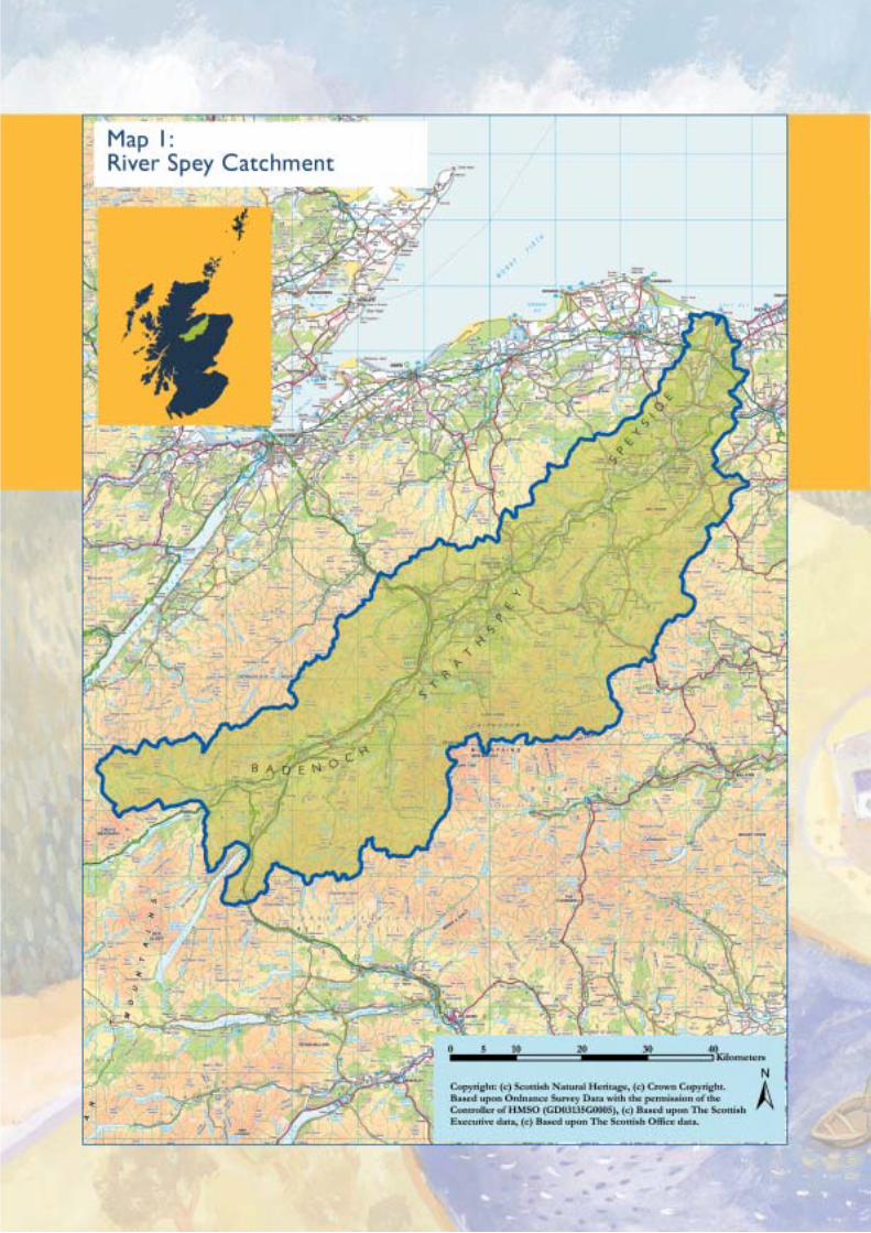
2.1 Catchment and AdministrativeBoundaries
The River Spey rises in the high ground of the Monadhliathand Cairngorm Mountain ranges and flows in a north-easterly direction through narrow straths and scenic rivervalleys before discharging into the Moray Firth beyond thefertile farmlands of Morayshire. The upper part of thecatchment is characterised by its mountainous areas, thehighest point being the summit of Ben Macdui at 1,309metres above sea level.
The River Spey is the seventh largest river in Britain, with acatchment area of over 3,000 km2, and a stream networklength of about 36,500 km, of which the main rivercomprises 157 km. The catchment is split between twoLocal Authority administrations, the Highland and MorayCouncils. Two thirds (67%) of the catchment falls within theCairngorms National Park and just over half (53%) of theNational Park area lies within the River Spey catchment(see map 2).
The terms ‘upper’ and ‘lower’ catchment mean differentthings to different people. Both these terms are usedfrequently throughout the document. Therefore, as ageneral guide, for the purpose of this document, the ‘upper’River Spey catchment is taken to be the land upstream ofabout Grantown-on-Spey. The upper catchment thereforeincludes many of the major tributaries, such as the riversDulnain, Nethy, Druie, Feshie, Tromie and Truim. On thisbasis the River Avon would be described as being in the‘lower’ catchment, but it should be noted that land-useactivities (e.g. hill sheep farming, forestry and sportingestates) in the upper reaches of the River Avon are similarto those activities found in the upper catchment generally.Reference should be made to the fold-out map attached tothe inside back cover of this document for names of riversand other places mentioned in the text.
2.2 Geology and Geomorphology
The solid geology of the River Spey catchment is dominatedby slow-weathering crystalline rocks (schists and gneisses) inthe uplands which were laid down in the Cambrian period.These are intruded in a number of places by granite and, tothe north, are overlain by Devonian ‘Old Red’ sandstones inthe Moray Firth coastal plain. In the north-east corner of thecatchment, a band of limestone rock runs in an arc fromDufftown to Tomintoul, both village communities havingexploited the rock with quarries. The limestone, a crystalline,metamorphic rock, has virtually no chemical effect on thewatercourse in this area and there is no noticeable differencein the pH compared with watercourses in other parts of thecatchment. Map 3 illustrates the solid geology of the RiverSpey catchment.
The river system was initiated in the mid-Tertiary, and duringthe last 500,000 years the geography of the catchment as wesee it today was moulded by a sequence of four ice ages.Glacial erosion deepened many valleys and when the glaciersmelted, barriers of sediment were deposited across the endof these valleys, causing the formation of long lochs such asLochs Ericht, Einich and Avon. Most of the lower valleys arefilled with outwash terraces and the coastal plain containssuperb raised beach shingle bar formations.
Following the retreat of the glaciers, drift deposits were laiddown over the bare rocks on the lower ground. Constantscouring by sand and water has meant that the bedrock ofthe higher ground, such as the Cairngorm plateau, has little orno soil cover. Thus, when it rains, there is little cover for thewater to soak into and it runs off directly into a watercourse.The burns on these hillsides react rapidly to any change inweather conditions, there is little water retention, and spatescan occur at any time of year.
For most of its length, the River Spey flows through a wide,alluvial plain composed of silts, sands and water-borne
River Spey
CATCHMENTMANAGEMENTPLAN
Catchment Review2
14
pebbles. In places, these large accumulations of sand andgravel are quarried as need arises. The plain is mostly fertilebut subject to periodic inundation, creating problems forfarmers and householders. In upland areas, there areextensive beds of peat, some many metres thick.
2.3 Precipitation and Climate Change
The NERPB’s 1995 Catchment Review shows that averageannual precipitation over the catchment broadly follows thatof the relief of the catchment, with the highest precipitation inthe mountainous areas and the lowest on the coastal plain ofthe Moray Firth. There are striking differences in the rainfallpattern between the upper and lower catchment. Forexample, while precipitation in the upper catchment fallspredominantly in the period August-February, it is the monthsof July and August which provide the highest rainfall in thelower catchment. The upper catchment receives most of itsprecipitation from frontal systems while the pattern of rainfallin the lower catchment is dominated by convective summerstorms. Much of the precipitation in winter months can fall assnow at all levels and there are semi-permanent snow beds insome of the highest, north-facing corries in the Cairngorms.
The Scottish climate is typified by mild winters andsuppressed daytime temperatures in spring and summer.Rainfall and extensive cloud cover are frequent along thewest coast, while the east is more continental in characterwith colder winters, warmer summers and less rain. Over thetwentieth century, Scotland has seen a 0.4˚C rise in theaverage annual temperature and more recently, annualprecipitation values across Scotland have increased, but withsignificant shifts in locational and seasonal trends. There is nowfirm evidence that these current changes are caused bygreenhouse gases rather than by natural changes in solarradiance.
The UK Climate Impacts Programme (1998) looked atclimate change scenarios for the whole of the UK. A furtherstudy conducted by the Scottish Executive (2001) consideredregional climate change scenarios for Scotland. This latterstudy reveals that overall we can expect a slight rise in themean and annual temperature. We can also expect anincrease in average annual rainfall with autumn and winterseasons receiving the greatest increase. However, it is possiblethat summer precipitation may decline in some areas andtrends from last century indicate that such regions may bethe north east (i.e. around Aberdeenshire).
The land and water resource management issues that arebeing addressed by this Plan are both affected and influencedby the current climate. It is important, therefore, that duerecognition is given to the predicted future scenarios at global,national and regional level. A number of the recommendedactions in this Plan, particularly those that relate to the controland management of river water, will be most affected by this.
2.4 Population and Employment
There are only 23,000 permanent residents in the catchmentarea, but Strathspey, especially around Aviemore andGrantown, has a large number of holiday visitors. So insummer, and during the ski season, population levels are muchhigher. Population growth is occurring around Aviemore butis fairly static elsewhere. The settlement pattern is traditionally
one of small planned towns (Kingussie, Grantown, Aberlour,Fochabers, Kingston) none of which is built up to the river’sedge – they maintain a healthy distance back! There arenumerous small villages of fewer than 500 residents (likeCarrbridge, Nethybridge, Craigellachie, Garmouth) but nocommunity (except Aviemore at the height of its touristseason) has more than 3,000 inhabitants. For all the activitiesin Badenoch, Strathspey and Speyside, this is a low populationdensity area.
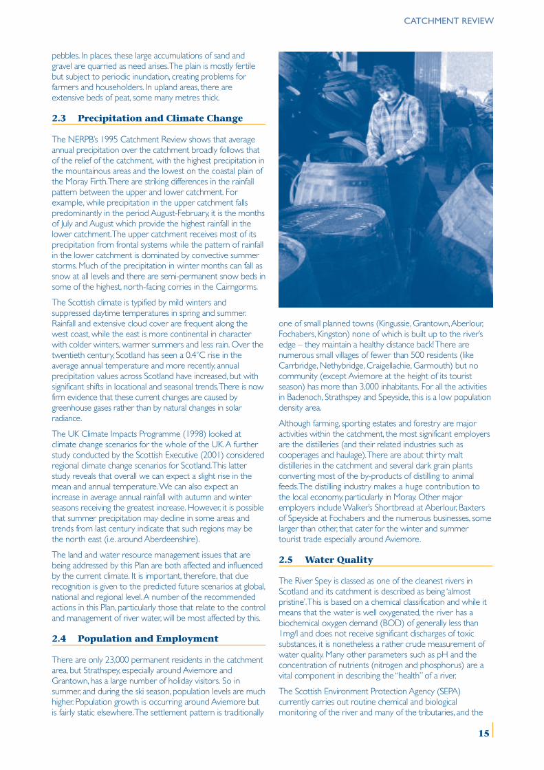
Although farming, sporting estates and forestry are majoractivities within the catchment, the most significant employersare the distilleries (and their related industries such ascooperages and haulage). There are about thirty maltdistilleries in the catchment and several dark grain plantsconverting most of the by-products of distilling to animalfeeds. The distilling industry makes a huge contribution tothe local economy, particularly in Moray. Other majoremployers include Walker’s Shortbread at Aberlour, Baxtersof Speyside at Fochabers and the numerous businesses, somelarger than other, that cater for the winter and summertourist trade especially around Aviemore.
2.5 Water Quality
The River Spey is classed as one of the cleanest rivers inScotland and its catchment is described as being ‘almostpristine’. This is based on a chemical classification and while itmeans that the water is well oxygenated, the river has abiochemical oxygen demand (BOD) of generally less than1mg/l and does not receive significant discharges of toxicsubstances, it is nonetheless a rather crude measurement ofwater quality. Many other parameters such as pH and theconcentration of nutrients (nitrogen and phosphorus) are avital component in describing the “health” of a river.
The Scottish Environment Protection Agency (SEPA)currently carries out routine chemical and biologicalmonitoring of the river and many of the tributaries, and the
CATCHMENT REVIEW
15
CATCHMENT REVIEW
16
combination of these is used to determine the river qualityclass. Much of the river and tributaries are in the highest class.The EC Water Framework Directive, which came into forcein December 2000, will introduce a new statutoryrequirement to set and achieve ‘good ecological status’ targetswhich will have the potential to protect and restore maritime,freshwater and wetland biodiversity. This will require a morecomprehensive classification system than currently in placeand will take account of flora, fauna, physical habitat, etc. Map4 shows the water quality classification for those parts of theRiver Spey and tributaries which have been graded.
2.6 Domestic and Industrial Water Supply
The majority of drinking water within the River Speycatchment is provided through a public supply network.However, numerous private supplies do serve single orgroups of domestic properties as well as commercialoperations, including many of the catchment’s whiskydistilleries. Scottish Water is responsible for supplying awholesome drinking water service to its customers andachieves this by making abstractions from a range of sources.Current demands for better drinking water quality havemeant that many smaller sources have been abandoned forstrategic regional schemes that allow for better control ofwater quality and reduce the overall treatment costs.However, small sources are still used in remote areas.
The flow of water through the catchment is monitored bySEPA, using a network of gauging stations. The lowest stationat Boat O’Brig shows an average daily flow of about 65m3swith a dry weather flow (Q95) of about 19m3s. A total of0.38m3s is currently abstracted for drinking water supply fromthe catchment, with a current limit of 0.45m3s. The WaterAuthority is required (under various Water Acts) to apply tothe Scottish Ministers for a Water Order if it requires anabstraction for public supply. There are two major sources inthe River Spey catchment controlled by such Water Orders; asurface abstraction at Loch Einich and a groundwaterabstraction from the river terrace gravels at Fochabers (theDipple Wellfield). The former supplies most of the towns andlarger villages of Badenoch & Strathspey upstream ofGrantown, with the subsequent effluent being returned tothe river via the various Waste Water Treatment Works(WWTW) in the upper catchment. The latter supplies muchof the Moray plain and results in a net export from the lowercatchment in the order of 75% of the total abstraction.
Despite the development of these large abstractions, thereremain a few local village supplies controlled by WaterOrders as well as numerous private sources which areuncontrolled, but which result in little net loss to the waterresource within the catchment.
2.7 Hydo-electric Power
The River Spey catchment is used at a number of points toprovide water, via diversion to neighbouring catchments forthe generation of hydro-power. There are two main schemesin operation in the upper catchment. Firstly, Scottish &Southern Energy plc diverts water from the catchments ofthe rivers Tromie and Truim to Loch Ericht (Tummel/Taycatchment). Secondly, Alcan Smelting & Power UK divertswater from the River Spey itself (at Spey Dam), and from the
River Mashie to the River Pattack (Loch Laggan/Speancatchment) for hydro-power generation at Fort William. It isestimated that as much as 70% of the water resources of theupper catchment are diverted for hydro-power generation.However, data on the actual quantities diverted are notcurrently available. The dams associated with these schemeshave little storage capacity, acting primarily as diversionarystructures. However, they do assist in the amelioration ofsome flood peak flows.
The schemes were established by various private Acts ofParliament between 1921 and 1942. The compensationarrangements have been designed to allow abstraction if thenatural flow is above 0.68m3s (the hands-off flow). If the flowfalls below this level then no abstraction occurs and all thewater is passed to the river. The hands-off flows have beensupplemented with physical features to allow the passage offish upstream, where appropriate, and 22 days of freshets arereleased from the Spey Dam to the river to provide anaspect of the hydrological regime necessary for the migrationof salmonids in the River Spey.
2.8 Flooding and Development
Development within the floodplain has created problems forboth property owners and Local Authorities alike. As a resultof a number of specific cases, and also in light of experienceelsewhere in Scotland, The Highland Council has instigatedmore stringent reviews of ‘zoning’ within the planning processin order to lessen the likelihood of future flooding. The sitingof new developments in the floodplain needs to be carefullyconsidered and consideration also needs to be given to thepossible consequences of flooding for existing buildings.
Planning Authorities have particular problems with planningapplications close to the river in the context of bothflooding and erosion. The uncertainty of future flood events,their height and intensity, make it difficult to pose questionson the likely outcome of any flood event. The Highland andMoray Councils adhere closely to the advice given in NationalPlanning Policy Guideline 7 on flooding (currently beingrevised under Scottish Planning Policy 7). As a consequence,any new developments should be secure from flooding fromknown rainfall events and river capacity. Currently a blanket 1in 100 year return period is used but variable periods arebeing considered based on risk assessment, e.g. hospitals andhouses need different levels of surety.
2.9 Fisheries
The River Spey is one of Western Europe’s primary rivers forAtlantic salmon and sea trout. During the period1997 to2001, the river supported a rod fishery with a 5-year averagecatch of 7,771 salmon and 3,485 sea trout. Figures from a1988 survey indicated that the rod fishery generated inexcess of £7 million per annum to the local economy, andemployed over 468 full-time equivalent jobs within thecatchment. The Spey Fishery Board was established under the1860s Salmon Fisheries legislation, as presently stated in theSalmon Act 1986, and is responsible for the management,protection, enhancement and conservation of salmon and seatrout stocks in the river.
This remit is carried out in a number of ways. Under itsmanagement arm, a team of bailiffs patrols the river and
17
CATCHMENT REVIEW
coastline to deter poachers. The bailiffs also run the Board’shatchery, where up to 1 million River Spey salmon arehatched and planted out to enhance depleted areas of theriver. As the Board’s research arm, the Spey Research Trustcarries out monitoring of stocks which helps to guidemanagement, such as stocking the river. The Research Trustalso promotes public awareness of the Board’s work, and hasa successful ‘Salmon Go To School’ programme where pupilsat local primary schools hatch and rear their own juvenile fishin the classroom.
Other fisheries also exist in the catchment, for brown trout,pike and eels, but little information is available on either theextent or economic importance. In addition, there are severalrainbow trout fisheries and trout farms. The management ofthese activities is not formally co-ordinated, but because allare linked to the sustainability of the salmon and sea troutfishery, the Spey Fishery Board is promoting integratedmanagement among all parties involved.
2.10 Natural Heritage
The aquatic fauna of the River Spey and tributaries reflect theclean nature and the physical and chemical changes thatoccur from source to mouth of the river, but there arerelatively few extremely rare species. The main stem of theRiver Spey was notified as a Site of Special Scientific Interestin 1998 on account of its important populations of Atlanticsalmon, sea lamprey, otter and freshwater pearl mussel. It isalso a candidate Special Area of Conservation under the ECHabitats Directive. The River Spey is one of the mostimportant rivers in Western Europe for freshwater pearlmussel and although stretches have been severely affected bypearl fishers, a recent survey has indicated a sizeablepopulation with a healthy breading stock. The mussel hasdeclined drastically throughout much of its global range. Twosections of the River Spey are of outstanding biological andgeomorphological interest. They are the lower River Spey andthe Insh Marshes. The former has a range of shingle islandsand alluvial alder woodland habitats on a scale that isexceptional in Britain, while the Insh Marshes represent thelast relatively natural example of all the great floodplainsystems which once dominated the valleys of Britain. It is alsoa great haven for winter migratory birds.
2.11 Land Use
Hill farming, forestry and sporting estates dominate the land-use pattern in the upper catchment, while cattle rearing,extensive commercial forestry and arable farming becomemore prevalent as the valley floor widens. Parts of the RiverSpey catchment also form very important water supplycatchment areas. Agricultural practices are limited to a largeextent by the topography of the catchment with only a verysmall area, about 5%, towards the northern end of thecatchment offering much flexibility. About 50% of the RiverSpey catchment is mountain and moorland and used asrough grazing. Between the unimproved rough grazings of thehigh ground and the more sheltered valley floor, theremaining 45% of ‘intermediate ground’ presents the mostdiversity of land use and the greatest likelihood of changesresulting from changing economic pressures. It is here thatthere is greatest competition between farming, forestry and
sport. The landform, underlying geology and soils allcontribute to shaping the land-use pattern for the River Speycatchment. Map 5 illustrates the major land classifications ofthe River Spey catchment.
2.12 Cultural Heritage
There is a wealth of cultural heritage associated with thenumerous bridges which span the River Spey. The river wasmostly forded or crossed by ferry until the 18th and 19th
centuries. At least ten small ferries plied the River Spey atappropriate points, some continuing until the 20th century.One of the oldest bridges on the River Spey is theGarvamore bridge, built in 1831 by General Wade. ThomasTelford designed the Craigellachie Bridge which was builtbetween 1812 and 1814 and is the oldest surviving bridge inScotland. The lowest bridge on the River Spey is the massiveGarmouth viaduct built in 1886. Its size and strength weremade necessary by the width and power of the River Speyhere, and by its constantly changing course. The ice house atTugnet is an impressive reminder of the importance of thesalmon netting operation at the mouth of the River Spey.
There is a reference to timber floating on the River Spey asearly as 1539. During the 18th and 19th centuries, Strathspeybecame the scene of the greatest log floating activity in thecountry and Speymouth became the premier exporter oftimber in Britain. There appear to have been periods of bitterconflict on the River Spey when floats demolished cruives(for catching salmon) and fights broke out between floatersand ghillies. After a series of legal actions the Courts upheldthe right to float timber. This right of navigation was endorsedin a more recent dispute taken to the House of Lords wherethe right to canoe down the River Spey and other rivers usedfor logging was upheld. Today the main navigational use of theRiver Spey is for recreation in the form of canoeing.
2.13 Recreation and Tourism
There are two water-sports centres in the catchment, at LochMorlich and Loch Insh. At Loch Morlich sailing and canoeing isrestricted to parts of the loch but at Loch Insh canoeists canalso travel down the River Spey. The River is particularly wellknown for the exciting ‘white water’ canoeing and rafting in itsmiddle reaches. Together, Badenoch, Strathspey and Speysideare popular holiday destinations and generate substantialincome annually through tourism for the local economy. TheSpeyside Way long-distance route has been extended andnow runs between Buckie and Aviemore with proposals toextend it further to Newtonmore in the future. Other localfootpaths exist or are planned and many of the villages alongthe River Spey enjoy informal access to the river forswimming and walking.
3.1 Environmental Quality Standards
Water quality within the River Spey catchment is generallyvery good, but in places, and on occasion the issue ofenrichment due to increased phosphorus and nitrogen levelsneeds to be addressed. Sewage discharges and agriculturalrun-off can cause an increase in nutrient levels. There havebeen incidents of blue-green algal blooms, which producetoxins, creating an animal and public health issue in some ofthe lochs around Aviemore. Potentially, this could be inconflict with recreational use in some areas. Carefulconsideration needs to be given to phosphate sourcesupstream of standing waters and there is scope for acombined project to establish nutrient limits for standingwaters in the catchment. There is also concern that, withmuch of the upper catchment being moorland, land-usechanges in these areas are managed in such a way thatimplications for water quality are fully addressed.
The concentration of copper, which can originate fromeffluent from discharges, does not meet the environmentalquality standard in some tributaries. However, there are alsotributaries where the background concentration is high dueto natural geological factors, such as the weathering ofcopper-containing minerals in, for example, the Ben Rinnescatchment.
Currently, the water quality requirements for SAC qualifyingspecies like freshwater pearl mussel and sea lamprey arepoorly understood. The species may be vulnerable toincreased phosphorus and nitrogen, due to the promotion ofgrowths of algae or plants on the river bed. Furthermore, theeffects of pollutants such as dissolved copper or low levels ofpesticides on freshwater pearl mussel are not known andthey are potentially at risk from discharges of sewage anddistillery effluent discharges, as well as diffuse pollution arisingfrom agricultural or forestry activity. Further research is
required into the water quality requirements of this species,as well as a better understanding of its tolerance to potentialpollutants.
3.2 Waste Water Discharges
Waste water can arise from domestic sources and fromindustrial activity. Generally speaking, the Waste WaterTreatment Plants (WWTP) in the catchment, treating bothsewage and industrial effluents, meet discharge consent levelsset by SEPA. Localised problems can occur occasionally, suchas surface water and foul sewage misconnections andproblems with Combined Sewer Overflows. It is often notunderstood that generally all the public drainage systemsserving settlements in the catchment are served by“combined” systems. At times of heavy rain the sewercapacity can be exceeded and overflows, which deal withsurges of water run-off from roofs and roadways, spill into thestreams. These discharges are generally untreated or receivesimple screening to remove gross sewage solids only. Theyare, however, only of a short duration.
With development pressure in areas not served by publicsewers, proliferation of septic tanks is an issue in some areas.Particular attention must also be made to rural development,such as caravan and camping sites (see issue 9.2). As part oftheir future investment programme, Scottish Water plans toupgrade a number of WWTPs throughout the catchmentover the next 5 years. In addition, Moray Council hasidentified the need for WWTP upgrades at Dufftown,Mosstodloch and Tomintoul to accommodate futuredevelopment. Investment works at WWTPs will be requiredto comply with the consent standards imposed on dischargesby SEPA. With the pressure for future growth, there is a needto consider existing and future WWTP capacities in thecontext of Planning Authority Strategic and Local Plans.
River Spey
CATCHMENTMANAGEMENTPLAN
Water Quality Issues3
18
While wastewater discharges are generally meeting consentlevels, parts of the river system do show enrichment fromtime to time. Enrichment can also be due to diffuse pollution(see 3.4 below) and spate conditions, neither of which can beaddressed through consents. There is also the question as towhether the existing consents are adequate for protectingthe receiving waters in light of the SAC status of the river. Itwill be important to establish clear standards for the receivingwaters and it would also be useful to explore possibletechniques for allocation of the River Spey’s capacity toabsorb wastewater discharges. This would also apply to non-sewage discharges. The Water Framework Directive containswithin it an objective of ‘no deterioration’. Where waterquality pressures are responsible for a deterioration inecological status or prevent the objective of reaching “goodecological status”, there will be a requirement for restorativemeasures to be put in place.
A by-product from wastewater treatment works is sewagesludge. Scottish Water’s policy is to seek a sustainable,beneficial and cost effective re-use wherever possible, andhave a number of outlets for sludge. Spreading on agriculturalland is one such outlet and this is monitored and recorded byScottish Water and SEPA. The relevant legislation is the SludgeUse in Agriculture Regulations 1989, and updated regulationsare expected in the near future. In anticipation of this, allsewage sludge is treated before being recycled to land.
The food and drinks industry is well represented in thecatchment. Some of the industrial effluent is treated incombination with sewage or separately, e.g. at many distilleriesand at Baxters of Speyside. The effluent from these industrialpremises is generally high in organic strength, giving a veryhigh biochemical oxygen demand (BOD) and there are alsoother issues to be considered, such as the pH and coppercontent of the waste. However, with neutralisation of the pH,addition of nutrients and balancing of flows, these wastes cannormally be treated effectively by conventional biologicaltreatment systems.
In addition to the organic effluents (from sewage, distilling andfood processing) there are other sources of point sourcepollution. These can come from mineral workings, where highconcentrations of suspended solids can be of concern, andfrom urban drainage. The latter is mainly from areas ofindustrial or residential development drained on a separatesystem. The problems include pollution by oil, suspendedsolids and occasionally toxic materials. SEPA promotes theestablishment of Sustainable Urban Drainage Systems(SUDS) and through planning liaison, new developments canincorporate “soft” engineering solutions to these historicalproblems. SEPA also encourages the Planning Authorities toinclude the requirement for these as a Local Plan policy.Recent amendments to the Building Regulations have alsopromoted these systems.
3.3 Discharge of Cooling Water FromDistilleries
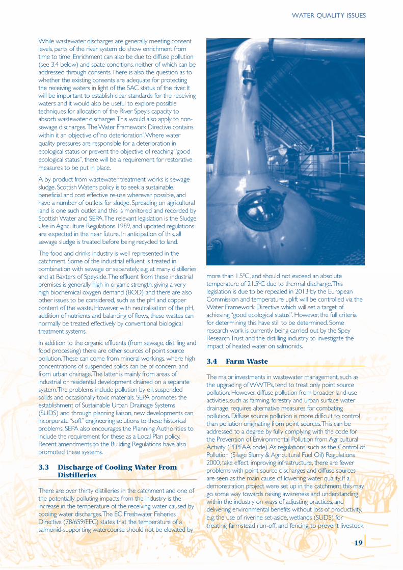
There are over thirty distilleries in the catchment and one ofthe potentially polluting impacts from the industry is theincrease in the temperature of the receiving water caused bycooling water discharges. The EC Freshwater FisheriesDirective (78/659/EEC) states that the temperature of asalmonid-supporting watercourse should not be elevated by
more than 1.50C, and should not exceed an absolutetemperature of 21.50C due to thermal discharge. Thislegislation is due to be repealed in 2013 by the EuropeanCommission and temperature uplift will be controlled via theWater Framework Directive which will set a target ofachieving “good ecological status”. However, the full criteriafor determining this have still to be determined. Someresearch work is currently being carried out by the SpeyResearch Trust and the distilling industry to investigate theimpact of heated water on salmonids.
3.4 Farm Waste
The major investments in wastewater management, such asthe upgrading of WWTPs, tend to treat only point sourcepollution. However, diffuse pollution from broader land-useactivities, such as farming, forestry and urban surface waterdrainage, requires alternative measures for combatingpollution. Diffuse source pollution is more difficult to controlthan pollution originating from point sources. This can beaddressed to a degree by fully complying with the code forthe Prevention of Environmental Pollution from AgriculturalActivity (PEPFAA code). As regulations, such as the Control ofPollution (Silage Slurry & Agricultural Fuel Oil) Regulations2000, take effect, improving infrastructure, there are fewerproblems with point source discharges and diffuse sourcesare seen as the main cause of lowering water quality. If ademonstration project were set up in the catchment this maygo some way towards raising awareness and understandingwithin the industry on ways of adjusting practices, anddelivering environmental benefits without loss of productivity,e.g. the use of riverine set-aside, wetlands (SUDS) fortreating farmstead run-off, and fencing to prevent livestock
WATER QUALITY ISSUES
19
WATER QUALITY ISSUES
from gaining access to watercourses.
The Groundwater Regulations 1998 requires SEPA to controlthe disposal of all List 1 and 11 substances, for example thosecontained in sheep dip and other pesticides. Disposals mayonly be made through an authorisation from SEPA. Sheep dipis considered a main threat, including the impact on privategroundwater drinking supplies, and the GroundwaterRegulations have tried to address the situation. However,movement towards mobile dippers may increase the loadingon a restricted number of sites and there are still concernsregarding flock management after dipping, especially wherethis takes place near watercourses.
The issue of diffuse pollution generally is not restricted merelyto ‘run-off ’, the effect of infiltration of fertilisers and pesticideson water quality (surface and groundwaters) gives cause forconcern. The promotion of buffer strips to protect surfacewater quality from phosphorus and nitrogen run-off wouldbe beneficial. The proposal to designate the lower part of thecatchment as a Nitrate Vulnerable Zone (NVZ) under theNitrates Directive, will address nutrient inputs in this area butin the upper reaches of the river, where oligotrophicconditions prevail, very small increases in nutrients can havesignificant environmental effects. This requires a moreproactive approach and the application of voluntaryrestrictions, in accordance with best practice.
Other types of pollution from a number of agriculturalsources can also pollute watercourses, e.g. organic manure,diesel, waste oil and plastics. A scheme to uplift agriculturalwaste has been piloted in the Cairngorms StrathsEnvironmentally Sensitive Area and this is now into its secondphase. A review of the success of this scheme would enablean assessment to be made of the desirability of extending itto the wider catchment. In addition, farm audits to checkstorage of oil, slurry and farm chemicals, together withnutrient budgeting and other good practice initiatives, wouldall facilitate environmental improvement.
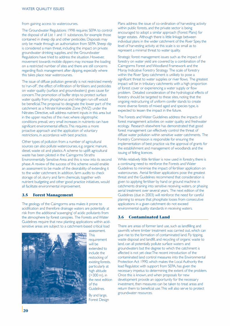
3.5 Forest Management
The geology of the Cairngorms area makes it prone toacidification and therefore drainage waters are potentially atrisk from the additional ‘scavenging’ of acidic pollutants fromthe atmosphere by forest canopies. The Forests and WaterGuidelines require that new planting applications within acid-sensitive areas are subject to a catchment-based critical load
assessment.Thisrequirementwill beextended toinclude therestocking ofexisting forests,particularly athigh altitude(>300 m), inthe next editionof theGuidelines.
By and large,Forest Design
Plans address the issue of co-ordination of harvesting activitywithin public forests, and the private sector is beingencouraged to adopt a similar approach (Forest Plans) forlarger estates. Although there is little linkage betweenindividual plans in the wider catchment of the River Spey, thelevel of harvesting activity at this scale is so small as torepresent a minimal threat to water quality.
Strategic forest management issues such as the impact offorestry on water yield are covered by a combination of theCairngorms Forest and Woodland Framework and theMoray Indicative Forestry Strategy. The scale of forestrywithin the River Spey catchment is unlikely to pose asignificant threat to water supplies or river flows. The greatestimpact will be in tributary catchments with a high proportionof forest cover or experiencing a water supply or flowproblem. Detailed consideration of the hydrological effects offorestry should be targeted to these sites, noting that theongoing restructuring of uniform conifer stands to createmore diverse forests of mixed aged and species type, isexpected to lessen the impact in the future.
The Forests and Water Guidelines address the impacts offorest management activities on water quality and freshwaterecology. Research elsewhere has demonstrated that goodforest management can effectively control the threat ofdiffuse water pollution within sensitive water catchments. TheForestry Commission is responsible for ensuring theimplementation of best practice via the approval of grants forthe establishment and management of woodlands and theissuing of felling licences.
While relatively little fertiliser is now used in forestry, there isa continuing need to reinforce the Forests and WaterGuidelines to minimise the impact of fertiliser application onwatercourses. Aerial fertiliser applications pose the greatestthreat and the Guidelines recommend that consideration isgiven to applying fertiliser by hand or ground machine incatchments draining into sensitive receiving waters, or phasingaerial treatment over several years. The next edition of theGuidelines (due in 2003) will reinforce the need for carefulplanning to ensure that phosphate losses from consecutiveapplications in a given catchment do not exceedenvironmental quality standards in receiving waters.
3.6 Contaminated Land
There are areas of former land use, such as landfilling andsawmills where timber treatment was carried out, which cangive rise to the formation of contaminated land. Fly tipping,waste disposal and landfill, and recycling of organic waste toland, can all potentially pollute surface waters andgroundwaters but the degree to which the catchment isaffected is not yet clear. The recent introduction of thecontaminated land control measures into the EnvironmentalProtection Act 1990, which makes the Local Authority thelead Regulator, with support from SEPA, has given thenecessary impetus to determining the extent of the problem.Once this is known, and when proposals for newdevelopment provide an opportunity for the necessaryinvestment, then measures can be taken to treat areas andreturn them to beneficial use. This will also serve to protectgroundwater resources.
20
ISSUE 3.1 ENVIRONMENTAL QUALITY STANDARDS
Water quality standards in the River Spey catchment are generally very good but there are localised enrichment problemsleading to incidents of blue-green algal blooms which need to be addressed.
Water quality requirements for the freshwater pearl mussel are poorly understood; the species may be vulnerable to increasedphosphorus and nitrogen and also to dissolved copper and low levels of herbicides.
MANAGEMENT OBJECTIVE 3.1
Maintain the current high water quality standards in the River Spey catchment and address local enrichment issues as theyoccur.
Determine the ecological requirements and tolerance limits of SAC qualifying species, with particular regard to sealamprey and freshwater pearl mussel.
No. Action Lead Others Timescale*
3.1.1 Using existing data, determine current trophic status of, SEPA SNH Mediumand set nutrient limits for, standing waters (>1km2)in the catchment.
3.1.2 Through research and field comparisons, establish SNH Research Institutes Shortecological requirements of freshwater pearl mussel SEPA Scottish Waterin terms of range of nutrient and pesticide concentrations.
3.1.3 Through research and study of existing data, establish SEPA Distillers Mediumfreshwater pearl mussel eco-toxicological levels for SNH Research Institutespollutants such as copper, including research into theforms and sources of copper which may be toxic.
* Short, medium and long are defined by 1 to 3 years, 4 to 6 years and 6 years plus respectively. This definition for the timescaleapplies throughout the document.
WATER QUALITY ISSUES
21
WATER QUALITY ISSUES
ISSUE 3.2 WASTEWATER DISCHARGES
Localised problems with wastewater discharges occur occasionally, usually as a result of sewer capacity being exceeded at timesof heavy rainfall or foul sewage cross-connections.
Development pressure in areas not served by public sewers is resulting in a proliferation of septic tanks.
There is a question as to whether current discharge consents are adequate for protecting the receiving waters of the catchment inlight of the river’s SAC status and how existing and future WWTP capacities will cope with the pressure for future growth.
MANAGEMENT OBJECTIVE 3.2
Improve effluent discharges where pollution is occurring and ensure the achievement of no deterioration in ecologicalstatus for the River Spey and tributaries.
Ensure that WWTP have sufficient capacity to cope with any planned expansions, either by industry or for residentialprovision, prior to approval of any such proposal.
No. Action Lead Others Timescale
3.2.1 With the objective of determining good ecological SEPA Scottish Water Mediumstatus, set water quality standards for the existing effluent SEERADdischarges to the receiving waters of the catchment. Industry
3.2.2 In the context of Local Authority Development Plans Scottish Water SEPA Shortand industry plans for expansion over the next Highland Council Industry10 years, assess existing WWTP capacity to ensure Moray Councilcompliance with water quality standards.
3.2.3 Monitor and record all wastewater treatment sludges Scottish SEPA Short/Mediumwhich are recycled to agricultural land and review sludge Water SEERADpolicy to reflect changing legislative requirements.
3.2.4 Promote the adoption of Sustainable Urban SEPA Highland Council ShortDrainage Systems (SUDS). Scottish Water Moray Council
3.2.5 Ensure discharge consents are set to protect water SEPA Scottish Water Mediumquality with particular regard to nutrients and their Industryecological effects.
ISSUE 3.3 DISCHARGE OF COOLING WATER FROM DISTILLERIES
Increases in river temperature caused by cooling water discharges from distilleries may have an adverse impact onaquatic ecology, and on salmonids in particular.
MANAGEMENT OBJECTIVE 3.3
Set discharge consents for distillery cooling waters, which both protect the ecology of receiving tributaries and meet therequirements of the relevant European Directives.
No. Action Lead Others Timescale
3.3.1 Agree the interpretation of ‘good ecological status’ SEPA SNH Shortin the context of temperature uplift in watercourses. SEERAD Industry
3.3.2 In the context of the EC Freshwater Fish and Water Distillers SEPA ShortFramework Directives, carry out further scientific SRT SEERADresearch into the impacts of temperature uplift on FRSsalmonids to ensure that good ecological status is achieved.
22
ISSUE 3.4 FARM WASTE
Diffuse pollution from land-use activities is more difficult to control than point source pollution. Diffuse pollution is notrestricted simply to “run-off”: the infiltration of pollutants such as fertilisers and pesticides gives cause for concern. Theoligotrophic waters of the upper part of the catchment are particularly sensitive to very small increases in nutrients.
MANAGEMENT OBJECTIVE 3.4
Raise awareness of the problems associated with diffuse pollution from land management practices and provide bettersupport mechanisms for combating the problem.
Ensure good ecological status is achieved through best practice management, through enforcement of the proposedNitrate Vulnerable Zone and through the Groundwater Regulations.
No. Action Lead Others Timescale
3.4.1 In conjunction with the Rural Stewardship Scheme and NFUS Farmers & Mediumother agricultural support systems (e.g. set-aside), identify FWAG Croftersareas and encourage farmers to enter schemes where SAC FWAGbuffer strips could most effectively improve riparian SFBhabitat and reduce the amount of diffuse pollution SNHentering watercourses.
3.4.2 Assess impact of pesticides on surface water and SEPA Scottish Water Mediumgroundwater and produce best practice guidelines. SEERAD
NFUS
3.4.3 Evaluate the success of the farm waste collection Agriculture Forum SEPA Shortscheme within the Cairngorms Straths ESA. FWAG
NFUS
3.4.4 Investigate the scope for improved farm waste SEERAD NFUS Shortmanagement through nutrient budgeting and other FWAG SLFwaste minimisation and efficiency measures. SFB
SEPASNH
3.4.5 Promote the adoption of nutrient budgeting and SEERAD NFUS Mediumsustainable drainage systems (SUDS: e.g. reed beds) for FWAGthe treatment of surface water in appropriate areas as SACidentified by the study in 3.4.4 above. SLF
SFBSNHSEPA
WATER QUALITY ISSUES
23
WATER QUALITY ISSUES
ISSUE 3.5 FOREST MANAGEMENT
The geology of the Cairngorms area makes it prone to acidification and acid-sensitive headwater catchments are likely to bemore vulnerable to the effects of forestry management practices.
The hydrological effects of forestry are likely to be greatest in tributary catchments with a high proportion of forest cover, orwhere there are water supply or flow issues.
MANAGEMENT OBJECTIVE 3.5
Develop a better understanding of the implications for water quality and freshwater ecology of forestry managementwithin the catchment.
No. Action Lead Others Timescale
3.5.1 Define acceptable limits for change at sub-catchment FC Highland Council Medium(or tributary) level, in terms of expanding the woodland Moray Councilarea and the extent of areas harvested. SEPA
SNH
3.5.2 Identify and develop plans for those tributary catchments FC SEPA Mediummost at risk from the effects of forestry on water yield Highland Counciland acidification. Moray Council
Forest of Spey
3.5.3 Explore the potential to co-ordinate felling in both public FC SEPA Mediumand private sector, particularly within acid-sensitive Highland Councilheadwater catchments. Moray Council
3.5.4 Assess the impact of harvesting on locally sensitive species FC SEPA Mediumsuch as freshwater pearl mussel. SNH
Scottish Water
3.5.5 Consider extending the pilot work at 3.4.4 to cover FC SEPA Shortrecent and past forestry schemes. SNH
Scottish Water
ISSUE 3.6 CONTAMINATED LAND
Historical practices have resulted in pockets of land which are contaminated with materials harmful to the environment but thedegree to which the catchment is affected is not yet clear.
MANAGEMENT OBJECTIVE 3.6
Through the powers of the Environmental Protection Act 1990, determine the extent of the problem of contaminatedland within the River Spey catchment and restore any such areas to beneficial use.
No. Action Lead Others Timescale
3.6.1 Complete an inventory of contaminated land within Highland Council SEPA Shortthe River Spey catchment. Moray Council
24
4.1 Flood Risk Areas
Flooding in a river catchment of this size poses a numberof problems, particularly for farmers and land managers,although there are also a few settlements within thecatchment that periodically are at risk of major inundationor are affected by localised flooding. Historically, the firstflood protection embankments in Badenoch & Strathspeywere constructed in 1788 and most of the embankmentswe see today were completed by about 1820. TheDepartment of Agriculture put forward further floodprotection proposals in the 1950s but these were neverimplemented.
The current Badenoch & Strathspey Local Plan identifiessome Flood Risk Areas, within which developmentproposals will be considered inter alia in the context ofpossible flooding. These Flood Risk Areas are based onflooding incidents along the River Spey in the late 1980sand early 1990s plus an assessment of flood-prone areasidentified in the Cuthbertson Report to Highland RegionalCouncil. Flood Prevention Schemes are programmed forsections of the River Gynack at Kingussie and the RiverSpey at Aviemore for 2003/04.
Moray Council has identified the settlements of Garmouthand Kingston as particularly at risk from flooding, due toalterations in the channel and coastline at the river estuary.A Flood Prevention Scheme for Garmouth is in thereserve programme of works, although currentlysecondary to the main Moray Flood Prevention Schemeprojects. There are no other flooding issues currentlyunder consideration along the length of the River Spey inMoray, although agricultural land is known to floodperiodically in the Rothes area.
There is a need to assess Flood Prevention Schemes fortheir likely effect on downstream interests. There is also aneed to assess the direct and indirect impacts of FloodPrevention Schemes on riparian habitats and species.
In terms of flood risk, research is required on the possiblefuture hydrology of the River Spey catchment(precipitation and flows) as a result of global warming. Thiswill not only inform flood risk, but will also inform thepossible needs for SUDS or upgraded CSOs to deal withsurge run-off, and more water supply upgrades to dealwith seasonal water shortages.
4.2 Recording Flood Events
Flood events that occur on the River Spey are complexand varied. They can be much more than just rainfallevents and flooding can occur in an area that has had norainfall. Snowmelt, flash flood tributaries, abnormal tides atthe river mouth, wind effects, size of sub-catchment, typeof ground cover and in-channel deposits all contribute to acomplex interaction of elements.
SEPA holds data on the peak levels and flows at manygauging stations in the River Spey catchment, several ofwhich have records dating back to 1951 or earlier. SEPA’spredecessor body also undertook brief surveys of theextent of the flood ‘envelope’ following the major floodingevents of the late 1980s and early 1990s. These are onpaper form at present. Flood envelope maps indicate thefull extent of inundation, but often neglect importantissues like the depth of flooding, although this can beascertained by subsequent surveying.
The two Local Authorities have statutory responsibilitiesunder the Flood Prevention and Land Drainage Act 1997
River Spey
CATCHMENTMANAGEMENTPLAN
4 Control of River Water Issues
25
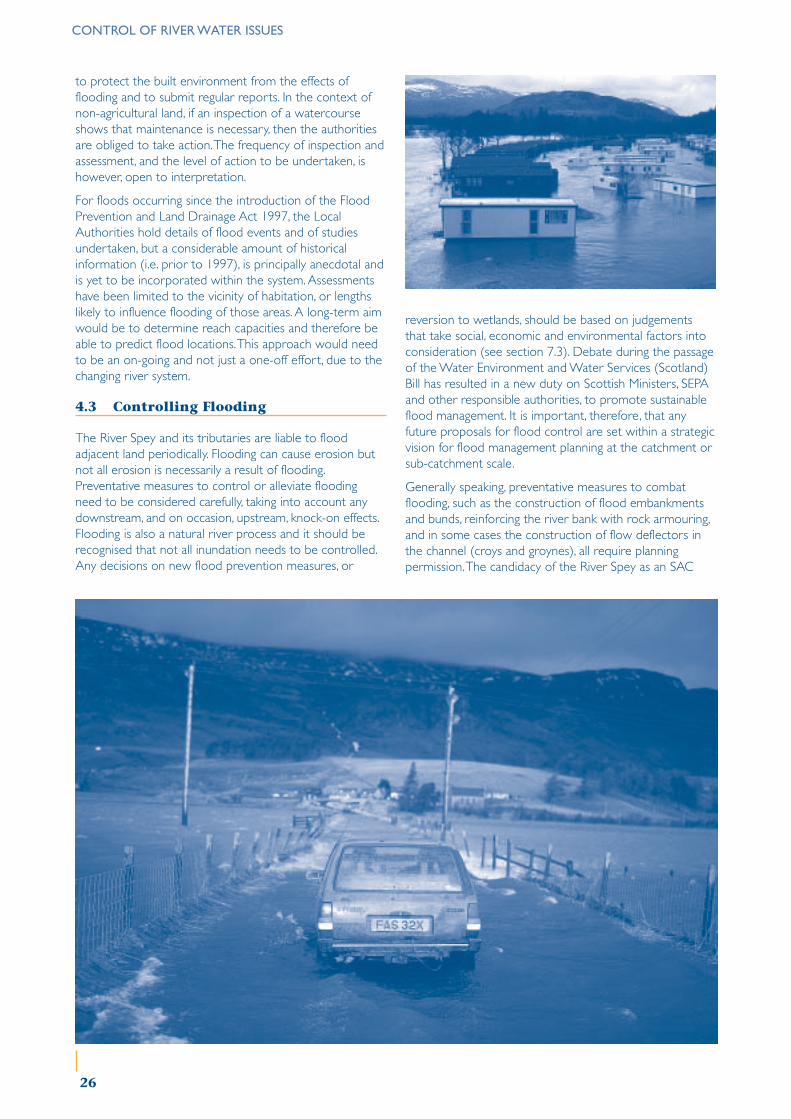
CONTROL OF RIVER WATER ISSUES
to protect the built environment from the effects offlooding and to submit regular reports. In the context ofnon-agricultural land, if an inspection of a watercourseshows that maintenance is necessary, then the authoritiesare obliged to take action. The frequency of inspection andassessment, and the level of action to be undertaken, ishowever, open to interpretation.
For floods occurring since the introduction of the FloodPrevention and Land Drainage Act 1997, the LocalAuthorities hold details of flood events and of studiesundertaken, but a considerable amount of historicalinformation (i.e. prior to 1997), is principally anecdotal andis yet to be incorporated within the system. Assessmentshave been limited to the vicinity of habitation, or lengthslikely to influence flooding of those areas. A long-term aimwould be to determine reach capacities and therefore beable to predict flood locations. This approach would needto be an on-going and not just a one-off effort, due to thechanging river system.
4.3 Controlling Flooding
The River Spey and its tributaries are liable to floodadjacent land periodically. Flooding can cause erosion butnot all erosion is necessarily a result of flooding.Preventative measures to control or alleviate floodingneed to be considered carefully, taking into account anydownstream, and on occasion, upstream, knock-on effects.Flooding is also a natural river process and it should berecognised that not all inundation needs to be controlled.Any decisions on new flood prevention measures, or
reversion to wetlands, should be based on judgementsthat take social, economic and environmental factors intoconsideration (see section 7.3). Debate during the passageof the Water Environment and Water Services (Scotland)Bill has resulted in a new duty on Scottish Ministers, SEPAand other responsible authorities, to promote sustainableflood management. It is important, therefore, that anyfuture proposals for flood control are set within a strategicvision for flood management planning at the catchment orsub-catchment scale.
Generally speaking, preventative measures to combatflooding, such as the construction of flood embankmentsand bunds, reinforcing the river bank with rock armouring,and in some cases the construction of flow deflectors inthe channel (croys and groynes), all require planningpermission. The candidacy of the River Spey as an SAC
26
CONTROL OF RIVER WATER ISSUES
brings with it additional controls of the operations thatpreviously enjoyed permitted development rights underthe General Permitted Development Order. In particular,this has implications for Class 20 of the GPDO foroperations designed to ‘improve or maintainwatercourses’.
Under certain circumstances, action has to be takenquickly to deal with flooding emergencies. Individualowners are responsible for dealing with floodingemergencies although Local Authorities have a general‘duty of care’ to assist with such incidents. The planningsystem does not recognise emergencies although someelements of the planning system do recognise that‘emergency works’, in the interest of public safety, may bea defence against enforcement action. The main stem ofthe River Spey is a designated SSSI and the 1981 Wildlife& Countryside Act also recognises that ‘emergency works’may be a defence against enforcement action, butunfortunately, like the Planning Acts, does not define‘emergency’.
The reservoirs on the Tromie and at Spey Damrespectively have no storage capacity or infrastructure touse their systems to regulate flood control or toameliorate the impacts of low flow. Essentially, these twoschemes are diverting water rather than storing water.Emptying of reservoirs as river levels rise might be a wayof mitigating a flood event and these two reservoirs couldbe used to ameliorate the effects of flooding. However, any‘spillage’ of water out of the reservoir represents a lostrevenue to the respective commercial interests. It may beadvisable to involve the industrial and commercialoperators within the catchment area in flood preventionplanning.
Control of river water through manipulating reservoirlevels could have an adverse impact on the ecology of therivers, and of the reservoirs themselves. A constant flow isnot necessarily in the best interest of the ecology of ariver as loss of river dynamics may result in an overall lossof biodiversity. Outflows from these schemes (the‘compensation flows’) were set in statute when theschemes were established and it is not yet clear how thiswill be affected by the imposition of new abstraction andimpoundment regulatory regimes under the WaterFramework Directive.
4.4 Flood Warning Schemes
SEPA has discretionary powers to implement floodwarning schemes and operates two of these within theRiver Spey catchment in partnership with the Police andLocal Authorities. The upper River Spey is divided intothree flood warning areas, from Spey Dam to Loch Insh,from Loch Insh to Grantown, and the River Dulnain. Thelower River Spey is divided into two flood warning areas,from Grantown to Fochabers and from Fochabers to SpeyBay.
An initial ‘Flood Watch’ alert, based on rising water levelsand weather forecast information, is generated for theupper and/or lower catchment areas. More serious ‘Flood
Warning’ or ‘Severe Flood Warning’ alerts, based on pre-set water level thresholds, are issued for the five sub-sections of the catchment. A total of 14 gauging stations,and rain gauges linked by telemetry, are used both togenerate alarms automatically and, by interrogation, formore detailed assessment of flood development. Alarmsare transmitted to base stations at SEPA offices in Dingwallor Aberdeen and automatically forwarded to SEPA dutyofficers who issue alerts to the Police and also to the‘Floodline’ recorded message system for the public. Theduty officers provide ongoing information and advice tothe Police and Local Authorities for the duration of theflood event. The ‘Floodline’ system is kept regularlyupdated with the latest alerts covering the various sectionsof the catchment. The public is encouraged to dial in toFloodline (0845 988 1188) to find out the latest floodwarning information, which may also be carried ontelevision and radio bulletins.
4.5 Maintenance (of watercourses, riverbanks, gravel beds, bridges and theriver mouth)
There are limited statutory obligations in terms of theFlood Prevention and Land Drainage Act 1997 for‘maintenance’ of watercourses in agricultural areas. Regularmaintenance of watercourses, such as repairing the riverbank and erosion hollows, or removing fallen trees oraccumulations of gravel from the channel, has declined inrecent years, primarily as a result of increasing costs.Furthermore, removal of river deposits, a readily availablesource of raw materials used for small-scale building anddevelopment projects, is no longer viable due to aggregatetax. This has tended to lead to larger-scale, but lessfrequent, intervention management, requiring the use ofmachinery.
Deposition downstream of a built structure, such as abridge or a croy, can create changes in the river channelthrough build-up of sediments. Changes can also occurthrough the natural accumulation of gravel and sedimentsin the river channel. Not to ‘maintain’ built structures, or toremove accumulations of gravel deposits, is viewed bysome as potentially having adverse consequences for thestructure in question or possibly flooding of adjacent land.Others view this as an opportunity for habitat creationand enhanced biodiversity, both within the channel and onadjacent land. There is also a view that ‘maintenance’proposals run the risk of damaging the river environment,including the habitat of specially protected species such assalmon and freshwater pearl mussel, or of making anoriginal problem worse. There is therefore divided opinionas to the social, economic and environmental benefits of‘maintaining’ a water course and this, like ‘emergencyworks’, is another concept requiring clarification anddefinition. Given these different perspectives, the‘maintenance’ of any water course should be viewed inlight of a strategic approach to management of the riversystem.
There is tension between land managers and regulatorybodies over the level at which ‘maintenance’ work is
27
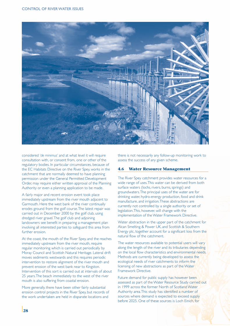
CONTROL OF RIVER WATER ISSUES
considered ‘de minimus’ and at what level it will requireconsultation with, or consent from, one or other of theregulatory bodies. In particular circumstances, because ofthe EC Habitats Directive on the River Spey, works in thecatchment that are normally deemed to have planningpermission under the General Permitted DevelopmentOrder, may require either written approval of the PlanningAuthority or even a planning application to be made.
A fairly major and recent erosion event took placeimmediately upstream from the river mouth adjacent toGarmouth. Here the west bank of the river continuallyerodes ground from the golf course. The latest repair wascarried out in December 2000 by the golf club, usingdredged river gravel. The golf club and adjoininglandowners see benefit in preparing a management planinvolving all interested parties to safeguard this area fromfurther erosion.
At the coast, the mouth of the River Spey, and the reachesimmediately upstream from the river mouth, requireregular monitoring which is carried out periodically byMoray Council and Scottish Natural Heritage. Lateral driftmoves sediments westwards and this requires periodicintervention to restore alignment of the river mouth andprevent erosion of the west bank near to Kingston.Intervention of this sort is carried out at intervals of about25 years. The beach immediately to the west of the rivermouth is also suffering from coastal erosion.
More generally, there have been other fairly substantialerosion control projects in the River Spey, but records ofthe work undertaken are held in disparate locations and
there is not necessarily any follow-up monitoring work toassess the success of any given scheme.
4.6 Water Resource Management
The River Spey catchment provides water resources for awide range of uses. This water can be derived from bothsurface waters (lochs, rivers, burns, springs) andgroundwaters. The principal uses of the water are fordrinking water, hydro-energy production, food and drinkmanufacture, and irrigation. These abstractions arecurrently not controlled by a single authority or set oflegislation. This, however, will change with theimplementation of the Water Framework Directive.
Water abstraction in the upper part of the catchment forAlcan Smelting & Power UK, and Scottish & SouthernEnergy plc, together account for a significant loss from thenatural flow of the catchment.
The water resources available to potential users will varyalong the length of the river and its tributaries dependingon the local flow characteristics and environmental needs.Methods are currently being developed to assess theecological needs of river catchments to inform thelicensing of new abstractions as part of the WaterFramework Directive.
Future demand for public supply has however beenassessed as part of the Water Resource Study carried outin 1999 across the former North of Scotland WaterAuthority area. This study has identified a number ofsources where demand is expected to exceed supplybefore 2025. One of these sources is Loch Einich, for
28
which improvements to the supply network have beenproposed to extend its life by reducing leakage andthereby increasing capacity.
Demand management should also be considered in futureto ensure that the supply is able to meet demand up toand beyond the strategic window of 2025. However, noassessment has been made of how the Water Authority’splans fit in with other planned uses of water and howthese might be exploited to address the needs of morethan one of the water users.
Data on the availability and use of water has so far not beenused to produce an integrated plan for the area to assistplanners and developers compared, for example, with theIndicative Forestry Strategies produced by Local Authorities.Furthermore, in some areas, current demand for waterresources is likely to exceed the capacity of current sourcesand appropriate strategies will need to be developed tomanage demand and develop alternative supplies. Key waterusers should be involved in the development of anintegrated water resource strategy for the catchment.’
4.7 Domestic and Industrial WaterSupply
The most significant abstractions have, to date, beenregulated and as such have been able to provide data onthe amounts of water taken from the catchment fordrinking water and hydro-power generation. Smallerabstractions however, depending on the time and locationof use, can also have a significant effect on the quality ofthe local watercourse.
As well as domestic and hydro-power water supply, theRiver Spey catchment also supports other industrial usersof water including the food and drink industry and theagriculture industry. Water is abstracted for industrialprocesses and may also be used as an ingredient forproducts themselves (e.g. in whisky). Cooling water usedby the distilling industry is returned to the river system.The use of water for irrigation by farmers and other landholders (e.g. golf courses) is primarily concentratedtowards the lower end of the Spey and its tributaries,where the cultivation of root crops is viable. As theseabstractions are not currently controlled by a regulatoryframework, little or no data are available about the extentand magnitude of these abstractions. However, some dataare available on water abstraction by the distillery sector.
Current abstractions from the catchment are regulated byusing a mix of mechanisms that focus on the mostsignificant users. Many potentially significant abstractionsare, therefore, not regulated at present. The WaterFramework Directive will require a review of theabstraction licensing system used in Scotland and it is likelythat a single agency will be appointed to administer thenew system. Abstractions, although of a significant scale,are not thought to be causing any problems for the statusof surface waters and groundwaters in the catchment. Itwould therefore be useful to address the magnitude andlocations of present abstractions to establish the mostappropriate level of control for different users.
CONTROL OF RIVER WATER ISSUES
29
ISSUE 4.1 FLOOD RISK AREAS
Flooding in a river catchment of this size poses a number of problems, particularly for farmers and land managers althoughthere are also a few settlements within the catchment that periodically are at risk from, or are affected by, localised flooding.
Flood Prevention Schemes must include assessments of their likely direct and indirect effects downstream and on riparianhabitats and species.
MANAGEMENT OBJECTIVE 4.1
Identify ‘Flood Risk’ areas in Local Authority Development Plans, with appropriate policies for controlling developmentand mitigating impact.
No. Action Lead Others Timescale*
4.1.1 Development Plans to identify flood risk or ‘flood Highland Council SEPA Shortconsultation’ areas, based on advice from SEPA, and Moray Councilfrom Flood Appraisal Groups, and to incorporatepolicies for control of development in such areas.
* Short, medium and long are defined by 1 to 3 years, 4 to 6 years and 6 years plus respectively. This definition for thetimescale applies throughout the document.
ISSUE 4.2 RECORDING FLOOD EVENTS
Flood events that occur on the River Spey are complex and varied. Access to flood data requires improvement.
SEPA holds data on the peak levels and flows at many gauging stations in the River Spey catchment, several of which haverecords dating back to 1951 or earlier. SEPA’s predecessor body undertook brief surveys of the extent of the flood ‘envelope’following the major flooding events of the late 1980s and 1990s. These are on paper form at present. Flood envelope mapsindicate the full extent of inundation, but often neglect important issues like the depth of flooding.
The Local Authorities hold details of flood events and of studies undertaken, but a considerable amount of historicalinformation (i.e. prior to 1997) is yet to be incorporated within the system. Assessments have been limited to the vicinityof habitation, or lengths likely to influence flooding of those areas.
MANAGEMENT OBJECTIVE 4.2
Improve the way that data are stored and disseminated about flood events to help identify flood-prone locationswithin the River Spey catchment.
No. Action Lead Others Timescale
4.2.1 Collate and disseminate historic flooding data into an Highland Council SEPA Shortelectronic system to improve understanding of Moray Councilhistoric events, and devise a system for predictivemodelling for flooding.
CONTROL OF RIVER WATER ISSUES
30
ISSUE 4.3 CONTROLLING FLOODING
The River Spey and its tributaries are liable to flood adjacent land periodically, posing problems particularly for farmers and landmanagers. Flooding is a natural process and not all inundation needs to be controlled. Decisions on new flood preventionschemes, or reversion to wetlands, should take social, economic and environmental factors into consideration.
It is difficult to agree on what constitutes an ‘emergency’ in the context of a dynamic river system like the River Spey.
Preventative measures to combat flooding, such as the construction of flood embankments and bunds, reinforcing the riverbank with rock armouring or the construction of flow deflectors in the channel (croys and groynes) may require planningpermission.
The River Spey SAC designation brings with it additional controls for operations that previously enjoyed permitteddevelopment rights under the General Permitted Development Order. In particular, this has implications for Class 20 of theGPDO for operations designed to ‘improve or maintain watercourses’.
There is tension between landowners/river managers and regulatory bodies over the bureaucracy and control mechanisms tocarry out works which are perceived as ‘essential’ or preventative; agreement on procedures is needed.
The Local Authorities have statutory responsibilities under the Flood Prevention and Land Drainage Act 1997 to protect thebuilt environment from the effects of flooding, but this does not extend to agricultural land.
In the context of non-agricultural land, if an inspection of a watercourse shows that maintenance is necessary, then theauthorities are obliged to take action. The frequency of inspection and assessment, and the level of action to be undertaken, ishowever open to interpretation.
Emptying of the loch ‘reservoirs’ on the Tromie and at Spey Dam as river levels rise might be a way of mitigating a floodevent. However, manipulating river levels like this could have an adverse impact on the ecology of the rivers and storagereservoirs, while any spillage or loss of water out of the loch ‘reservoirs’ represents lost revenue to the industry.
MANAGEMENT OBJECTIVE 4.3
Develop a catchment-wide, strategic vision for flood management and identify areas appropriate for natural inundation,and areas for which flood controls are appropriate. Reach agreement and understanding over a definition for ‘emergency’in the context of flooding and ensure that all regulatory bodies work to a standard development control framework fordealing with ‘emergencies’ in light of current legislation.
No. Action Lead Others Timescale
4.3.1 Investigate the terms of reference for a strategic Flood Highland Council ShortManagement Plan for the whole catchment area. Moray Council
4.3.2 Achieve an understanding of ‘emergency’ in the context SCSG Scottish Executive Mediumof flood conditions.
4.3.3 Produce guidelines in the form of a published ‘Code SCSG Shortof Practice’ for the control of works on the river andriver banks, which includes (i) procedures for dealingwith emergencies resulting from flood conditions, (ii)procedures for agreeing ‘preventative’ essentialmaintenance works.
4.3.4 Produce a ‘Code of Practice’ for assessing the impact of, SCSG Mediumand consulting on, works deemed necessary to protectthe built environment from flooding.
4.3.5 Involve business interests in flood prevention planning. Highland Council SNH MediumMoray Council SEPA
SFBBusiness Interests
CONTROL OF RIVER WATER ISSUES
31

ISSUE 4.4 FLOOD WARNING SCHEMES
SEPA has discretionary powers to implement flood warning schemes and operates these in partnership with the Policeand Local Authorities. Flood warning alerts are generated automatically and issued to the Police by SEPA duty officers.The latest information on flood alerts is also placed on the ‘Floodline’ system for dial-up access by the public.
MANAGEMENT OBJECTIVE 4.4
Ensure that an effective flood warning system continues to operate in the River Spey catchment.
No. Action Lead Others Timescale
4.4.1 Continue to monitor and review the effectiveness of the SEPA Northern & Grampian ShortRiver Spey flood warning system. Constabulary
Highland CouncilMoray Council
CONTROL OF RIVER WATER ISSUES
32
ISSUE 4.5 MAINTENANCE (OF WATERCOURSES, RIVER BANKS, GRAVEL BEDS,BRIDGES AND THE RIVER MOUTH)
There is no requirement under the Flood Prevention and Land Drainage Act for ‘maintenance’ of watercourses in agriculturalareas.
Regular maintenance of watercourses, such as repairing the river bank, small-scale erosion hollows, or removing fallen trees oraccumulations of gravel from the channel, has declined in recent years, primarily as a result of increasing costs.
There is tension between land owners/river managers and regulatory bodies over the level at which ‘maintenance’ work isconsidered ‘de minimus’ and at what level it will require consultation with, or consent from, one or other of the regulatorybodies.
Immediately upstream from the river mouth adjacent to Garmouth, the west bank continually erodes ground from the golfcourse. At the mouth of the River Spey, lateral drift moves sediments westwards requiring periodic intervention to restorealignment of the river mouth and prevent erosion of the west bank near to Kingston.
There have been other fairly substantial erosion control projects throughout the catchment, but records of the workundertaken are held in disparate locations and there is little follow-up monitoring to assess the success of any scheme.Many works are undertaken as ‘emergency works’ but there is no legal definition of ‘emergency’.
MANAGEMENT OBJECTIVE 4.5
Reach agreement and understanding over definitions for ‘maintenance’ and ‘de minimus’ and ensure that all regulatorybodies work to a standard development control framework in light of current legislation. Improve the analysis andmonitoring of past and present erosion control schemes in the river catchment.
No. Action Lead Others Timescale
4.5.1 Investigate the opportunities and constraints of an SCSG SLF Medium‘Agreement’ between regulatory bodies, and owners, asto an annual programme of ‘maintenance’.
4.5.2 Consider creation of a register of erosion maintenance SEPA Moray Council Shortworks, both those already completed, and those proposed, Highland Counciland ensure monitoring and assessment of the effects. SNH
4.5.3 Prepare a Management Plan for the highly dynamic lower Moray Council SNH Shortstretch of the River Spey which would seek to integrate SEPAland and fishery management objectives with the Crown Estateconservation objectives for the various features and G Lennox Estateprocesses of natural heritage importance concentrated Speymouth Anglingon this part of the river. Assoc.
G&K GCSWT
FESW
4.5.4 Achieve an understanding of, ‘emergency’, ‘maintenance’ SCSG Scottish Executive Mediumand ‘de minimus’ in the context of river works to preventor repair erosion.
CONTROL OF RIVER WATER ISSUES
33
ISSUE 4.6 WATER RESOURCE MANAGEMENT
The water resources available to potential users vary along the length of the river and its tributaries, depending on local flowcharacteristics and environmental needs.
No integrated assessment of the water resource available within the catchment has been made for the River Spey to date.
Water abstraction in the upper part of the catchment for industrial purposes accounts for a significant loss from the naturalflow of the catchment. It is also recognised that the limited storage of these schemes does not lend itself to retention of waterfor release during low flow periods, but this may need further investigation.
Any ‘spillage’ or loss of water out of the loch reservoirs represents lost revenue to the industry.
MANAGEMENT OBJECTIVE 4.6
Gain a better understanding of the overall water resource capability of the River Spey catchment and establish theoptimum low flow mitigation measures for the catchment, taking account both of socio-economic and environmentalconsiderations, as well as engineering and legislative constraints.
No. Action Lead Others Timescale
4.6.1 Establish and map the available water resources for the SEPA SSE MediumRiver Spey catchment. (see 9.1.6). Alcan Smelting
Scottish Water
4.6.2 Investigate the opportunities and constraints of an Alcan Smelting Highland Council Long‘Agreement’ with the two major water diverting SSE Moray Councilcompanies to manipulate flows in times of drought SEPA SNHthreat. SFB
ISSUE 4.7 DOMESTIC AND INDUSTRIAL WATER SUPPLY
The principal uses of the water resource are for drinking water, hydro-energy production, food and drink manufacture, andirrigation.
A Water Resource Study carried out by NoSWA in 1999 identified a number of sources where water demand is expected toexceed supply before 2025.
No assessment has been made of how the Water Authority’s plan fits in with other planned uses of water. Key water usersneed to be involved in the development of an integrated water resource strategy for the catchment.
The most significant abstractors are regulated and, as such, have been able to provide data on abstractions. Smallerabstractors, however, are unregulated and, depending on the time and location of use, can have a significant effect on thequality of a local watercourse.
MANAGEMENT OBJECTIVE 4.7
Establish an integrated approach for assessing future demand for domestic and industrial water supply.
No. Action Lead Others Timescale
4.7.1 Develop an integrated water resource strategy (domestic, SEPA Scottish Water Shortcommercial, agricultural and hydro) in order to plan for SSEsustainable levels of abstraction. Distilleries
NFUSAlcan Smelting
SFBHighland CouncilMoray Council
CONTROL OF RIVER WATER ISSUES
34
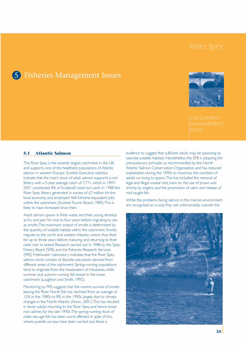
River Spey
CATCHMENTMANAGEMENTPLAN
5.1 Atlantic Salmon
The River Spey is the seventh largest catchment in the UK,and supports one of the healthiest populations of Atlanticsalmon in western Europe. Scottish Executive statisticsindicate that the river’s stock of adult salmon supports a rodfishery with a 5-year average catch of 7,771, which in 1997-2001 constituted 8% of Scotland’s total rod catch. In 1988 theRiver Spey fishery generated in excess of £7 million for thelocal economy, and employed 468 full-time equivalent jobswithin the catchment (Scottish Tourist Board, 1989). This islikely to have increased since then.
Adult salmon spawn in fresh water, and their young developas fry and parr for one to four years before migrating to seaas smolts. The maximum output of smolts is determined bythe quantity of suitable habitat within the catchment. Smoltsmigrate to the north and western Atlantic, where they feedfor up to three years before maturing and returning to theirnatal river to breed. Research carried out in 1988 by the SpeyFishery Board (SFB) and the Fisheries Research Services(FRS) Freshwater Laboratory indicates that the River Speysalmon stock consists of discrete sub-stocks derived fromdifferent areas of the catchment. Spring-running populationstend to originate from the headwaters of tributaries, whilesummer and autumn-running fish breed in the lowercatchment (Laughton and Smith, 1992).
Monitoring by FRS suggests that the marine survival of smoltsleaving the River North Esk has declined from an average of15% in the 1980s to 8% in the 1990s, largely due to climaticchanges in the North Atlantic (Anon., 2001). This has resultedin fewer adults returning to the River Spey, and hence lowerrod catches for the late 1990s. The spring-running stock ofolder sea-age fish has been worst affected. In spite of this,where juvenile surveys have been carried out, there is
evidence to suggest that sufficient adults may be spawning tosaturate suitable habitats. Nonetheless, the SFB is adopting theprecautionary principle, as recommended by the NorthAtlantic Salmon Conservation Organisation, and has reducedexploitation during the 1990s to maximise the numbers ofadults surviving to spawn. This has included the removal oflegal and illegal coastal nets, bans on the use of prawn andshrimp by anglers, and the promotion of catch and release ofrod-caught fish.
While the problems facing salmon in the marine environmentare recognised as crucial, they are unfortunately outwith the
Fisheries Management Issues5
35
FISHERIES MANAGEMENT ISSUES
scope of the Catchment Management Plan. However,several freshwater factors also threaten the health of theRiver Spey’s salmon population, all of which are within thescope of integrated catchment management. These includeman-made barriers to fish passage, water quality, predationof adults and juveniles, degradation of juvenile andspawning habitat through civil engineering and pollution,and the introduction of disease, parasites, and non-nativespecies. If the salmon population is to be managedsustainably, action should be taken to identify, prevent andrectify these threats. A detailed programme of researchand monitoring is also required to manage such problems,and to assess the status of the salmon population. Throughits statutory duties the SFB already addresses many ofthese issues, in collaboration with riparian owners,government agencies and Local Authorities. However, in2003 the SFB will carry out a review of its activities, andformulate a five year fishery management plan. The issuesand objectives presented here will be addressed in greaterdetail in the course of this exercise.
5.2 Brown Trout and Sea Trout
Brown trout are ubiquitous throughout the River Speycatchment. Scottish Executive statistics show that the sea-going form of the species (‘sea trout’) provides a significantrod fishery, with a 5-year average catch of 3,485. In 1997-2001 the River Spey sea trout fishery constituted 10% ofthe total Scottish rod catch, and the River Spey istherefore one of the country’s premier sea trout rivers.
Resident brown trout also provide localised fisheries, buttheir economic importance is difficult to assess due to theinformal nature of management. Access to fishing is eitheradministered by angling associations or estates issuing daytickets, or is not controlled at all. There is one formalProtection Order in place in the upper River Spey andSpey Dam area, managed by the Badenoch & StrathspeyAngling Association. To maintain revenue, manyassociations and estates augment stocks by introducingnon-native hatchery-reared trout. However, such stockingmay have detrimental effects on other fisheries and greaterco-ordination is required.
Despite the significance of the fisheries, the biology of theRiver Spey’s brown and sea trout populations is poorlyunderstood. FRS research throughout Scotland suggeststhat there may be several sub-stocks of trout within thecatchment, ranging from those which have access to thesea, to those that are isolated above waterfalls or in hilllochs. However, all trout have similar biologicalrequirements to those of salmon, including clean water,access to suitable spawning habitat, and an adequate foodsupply. In contrast to salmon, however, juvenile trout preferdeeper water and areas with abundant riparian vegetation,and therefore require a different approach to habitatmanagement.
Hence many of the factors that potentially affect salmon infresh water also impact upon trout, and actions to avoidthese will be mutually beneficial for both species. Since theSFB is also responsible for the conservation of sea trout, its
fishery management plan will consider management andresearch for all trout in the catchment.
5.3 Rainbow Trout
Rainbow trout are not native to Scotland, but have beenintroduced to the River Spey catchment for both fisheryand aquacultural purposes. There are four commercial put-and-take fisheries, and several private lochs and pondsoperating informal fisheries. However, there is noinformation on the economic value of these fisheries. Inaddition there are two trout farms within the catchment,run by Rothiemurchus Estate (Aviemore) and InvernessFish Farming (Alvie).
The major issue regarding rainbow trout is their ecologicalimpact on native fish species when introduced to lochs, orwhen they escape into the River Spey and its tributaries.Although neither the SFB nor FRS have evidence of self-sustaining populations within the catchment, rainbow troutmay disrupt indigenous freshwater ecosystems bycompeting with salmon and trout for food, and preying onmembers of all other fish species. However, there is no co-ordination of the introduction or distribution of rainbowtrout within the catchment.
The movement of fish (rainbow trout, brown trout, salmonand Arctic charr) into the River Spey catchment as part ofthe operation of the two fish farms may pose problems.Diseases and parasites are known to proliferate withinfarmed stocks, and can be transmitted to wild fishpopulations. Currently the regulations governingaquaculture are being reviewed by the Scottish Executive,and the Highland Council is developing Framework Plansfor fish farming to avoid such problems. Despite theeconomic importance of rainbow trout fisheries and farmsin the catchment, more co-ordination is required tomanage their potential impact on indigenous fish species.
5.4 Pike
Pike are common in the slower-flowing, middle reaches ofthe River Spey, and also in lochs Insh, Morlich and Alvieand at Spey Dam. The pike population supports a smallfishery which could be expanded if promoted more widely.However, as for brown trout, there is little biologicalinformation to support the management of such a fishery.
There are two perceived issues regarding the pikepopulation. First, the species has been regarded as a majorpredator of salmon and trout, and numbers have beencontrolled in the past by the SFB using nets. Second,angling for pike can involve the use of live bait brought infrom outside the catchment. This poses a threat in termsof the introduction of disease. Furthermore, bait is oftenreleased alive after fishing, and in other parts of Scotlandmay have resulted in the introduction of non-nativespecies, often with adverse effects for the indigenous fishcommunities. So far, this is not known to have occurred inthe River Spey catchment, but there is a need to prevent itby managing the pike fishery more effectively. While theScottish Federation for Coarse Angling (SFCA) and the
36
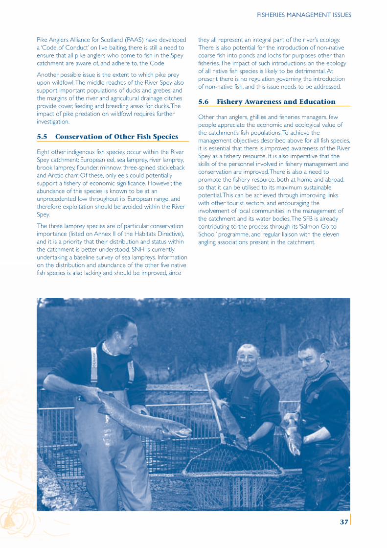
FISHERIES MANAGEMENT ISSUES
Pike Anglers Alliance for Scotland (PAAS) have developeda ‘Code of Conduct’ on live baiting, there is still a need toensure that all pike anglers who come to fish in the Speycatchment are aware of, and adhere to, the Code
Another possible issue is the extent to which pike preyupon wildfowl. The middle reaches of the River Spey alsosupport important populations of ducks and grebes, andthe margins of the river and agricultural drainage ditchesprovide cover, feeding and breeding areas for ducks. Theimpact of pike predation on wildfowl requires furtherinvestigation.
5.5 Conservation of Other Fish Species
Eight other indigenous fish species occur within the RiverSpey catchment: European eel, sea lamprey, river lamprey,brook lamprey, flounder, minnow, three-spined sticklebackand Arctic charr. Of these, only eels could potentiallysupport a fishery of economic significance. However, theabundance of this species is known to be at anunprecedented low throughout its European range, andtherefore exploitation should be avoided within the RiverSpey.
The three lamprey species are of particular conservationimportance (listed on Annex II of the Habitats Directive),and it is a priority that their distribution and status withinthe catchment is better understood. SNH is currentlyundertaking a baseline survey of sea lampreys. Informationon the distribution and abundance of the other five nativefish species is also lacking and should be improved, since
they all represent an integral part of the river’s ecology.There is also potential for the introduction of non-nativecoarse fish into ponds and lochs for purposes other thanfisheries. The impact of such introductions on the ecologyof all native fish species is likely to be detrimental. Atpresent there is no regulation governing the introductionof non-native fish, and this issue needs to be addressed.
5.6 Fishery Awareness and Education
Other than anglers, ghillies and fisheries managers, fewpeople appreciate the economic and ecological value ofthe catchment’s fish populations. To achieve themanagement objectives described above for all fish species,it is essential that there is improved awareness of the RiverSpey as a fishery resource. It is also imperative that theskills of the personnel involved in fishery management andconservation are improved. There is also a need topromote the fishery resource, both at home and abroad,so that it can be utilised to its maximum sustainablepotential. This can be achieved through improving linkswith other tourist sectors, and encouraging theinvolvement of local communities in the management ofthe catchment and its water bodies. The SFB is alreadycontributing to the process through its ‘Salmon Go toSchool’ programme, and regular liaison with the elevenangling associations present in the catchment.
37
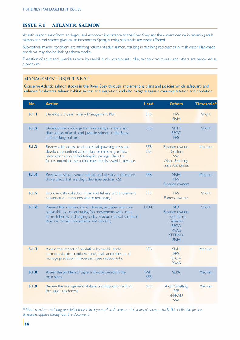
FISHERIES MANAGEMENT ISSUES
ISSUE 5.1 ATLANTIC SALMON
Atlantic salmon are of both ecological and economic importance to the River Spey and the current decline in returning adultsalmon and rod catches gives cause for concern. Spring-running sub-stocks are worst affected.
Sub-optimal marine conditions are affecting returns of adult salmon, resulting in declining rod catches in fresh water. Man-madeproblems may also be limiting salmon stocks.
Predation of adult and juvenile salmon by sawbill ducks, cormorants, pike, rainbow trout, seals and otters are perceived asa problem.
MANAGEMENT OBJECTIVE 5.1
Conserve Atlantic salmon stocks in the River Spey through implementing plans and policies which safeguard andenhance freshwater salmon habitat, access and migration, and also mitigate against over-exploitation and predation.
No. Action Lead Others Timescale*
5.1.1 Develop a 5-year Fishery Management Plan. SFB FRS ShortSNH
5.1.2 Develop methodology for monitoring numbers and SFB SNH Shortdistribution of adult and juvenile salmon in the Spey, SFCCand stocking policies. FRS
5.1.3 Review adult access to all potential spawning areas and SFB Riparian owners Mediumdevelop a prioritised action plan for removing artificial SSE Distillersobstructions and/or facilitating fish passage. Plans for SWfuture potential obstructions must be discussed in advance. Alcan Smelting
Local Authorities
5.1.4 Review existing juvenile habitat, and identify and restore SFB SNH Mediumthose areas that are degraded (see section 7.5). FRS
Riparian owners
5.1.5 Improve data collection from rod fishery and implement SFB FRS Shortconservation measures where necessary. Fishery owners
5.1.6 Prevent the introduction of disease, parasites and non- LBAP SFB Shortnative fish by co-ordinating fish movements with trout Riparian ownersfarms, fisheries and angling clubs. Produce a local ‘Code of Trout farmsPractice’ on fish movements and stocking. Fisheries
SFCAPAAS
SEERADSNH
5.1.7 Assess the impact of predation by sawbill ducks, SFB SNH Mediumcormorants, pike, rainbow trout, seals and otters, and FRSmanage predation if necessary (see section 6.4). SFCA
PAAS
5.1.8 Assess the problem of algae and water weeds in the SNH SEPA Mediummain stem. SFB
5.1.9 Review the management of dams and impoundments in SFB Alcan Smelting Mediumthe upper catchment. SSE
SEERADSW
* Short, medium and long are defined by 1 to 3 years, 4 to 6 years and 6 years plus respectively. This definition for thetimescale applies throughout the document.
38
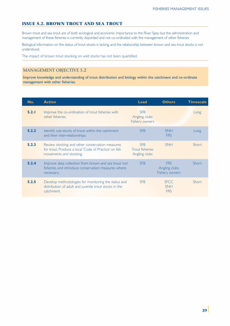
FISHERIES MANAGEMENT ISSUES
ISSUE 5.2. BROWN TROUT AND SEA TROUT
Brown trout and sea trout are of both ecological and economic importance to the River Spey but the administration andmanagement of these fisheries is currently disjointed and not co-ordinated with the management of other fisheries.
Biological information on the status of trout stocks is lacking, and the relationship between brown and sea trout stocks is notunderstood.
The impact of brown trout stocking on wild stocks has not been quantified.
MANAGEMENT OBJECTIVE 5.2
Improve knowledge and understanding of trout distribution and biology within the catchment and co-ordinatemanagement with other fisheries.
No. Action Lead Others Timescale
5.2.1 Improve the co-ordination of trout fisheries with SFB Longother fisheries. Angling clubs
Fishery owners
5.2.2 Identify sub-stocks of trout within the catchment SFB SNH Longand their inter-relationships. FRS
5.2.3 Review stocking and other conservation measures SFB SNH Shortfor trout. Produce a local ‘Code of Practice’ on fish Trout fisheriesmovements and stocking. Angling clubs
5.2.4 Improve data collection from brown and sea trout rod SFB FRS Shortfisheries, and introduce conservation measures where Angling clubsnecessary. Fishery owners
5.2.5 Develop methodologies for monitoring the status and SFB SFCC Shortdistribution of adult and juvenile trout stocks in the SNHcatchment. FRS
39
FISHERIES MANAGEMENT ISSUES
ISSUE 5.3 RAINBOW TROUT
Rainbow trout have been introduced to the catchment by fish farms and put-and-take trout fisheries, but fish movements andstocking are not co-ordinated with other fishery activities.
Escapes of rainbow trout may have detrimental effects on native fish species.
Regulations governing fish farms are currently under review by the Government, and recommendations have been madefor Local Authorities to produce Framework Plans for the operation and development of aquaculture.
MANAGEMENT OBJECTIVE 5.3
Further the knowledge and understanding of the impact of rainbow trout on native fish species and co-ordinate fish farmingwith other fishery activities.
No. Action Lead Others Timescale
5.3.1 Improve the management of rainbow trout introductions SNH FRS Shortthrough the development of a local ‘Code of Practice’ Trout farms SFBon fish movements and stocking’. Fisheries
LBAP
5.3.2 Review trout farm and fishery operations to prevent Trout farms SNH Mediumescapes and disease. Fisheries SFB
5.3.3 Develop a Framework Plan for future trout farm Local Authorities SNH Mediumdevelopments in the catchment. Trout farms FRS
Fisheries SFB
40
FISHERIES MANAGEMENT ISSUES
ISSUE 5.4 PIKE
The pike fishery is under-utilised and not co-ordinated with the management of other fisheries within the catchment.
Pike prey on salmon, trout and other species (including wildfowl), but whether they have an impact on these species in theRiver Spey should be researched.
The use of live-bait fishing for pike can result in the introduction of non-native fish.
MANAGEMENT OBJECTIVE 5.4
Promote and manage the pike fishery more effectively and prevent the introduction of non-native fish species throughlive baiting.
No. Action Lead Others Timescale
5.4.1 Promote the Spey catchment’s pike fishery. PAAS VisitScotland MediumSFCA SFB
Fishery Owners
5.4.2 Prevent the introduction of non-native fish species by LBAP VisitScotland Shortpromoting the SFCA and PAAS ‘Code of Conduct’ on PAAS FRSlive baiting. SFCA
Fishery Owners
5.4.3 Integrate the management of pike with other fisheries. SFB FRS MediumPAASSFCA
5.4.4 Assess the diet of pike within the Spey catchment SFB Pike anglers Longrelative to available prey populations. SFCA SNH
PAAS FRSRSPBSWT
ISSUE 5.5 CONSERVATION OF OTHER FISH SPECIES
Eight other fish species occur in the River Spey catchment but little is known of their distribution and abundance.
Eels have supported informal fisheries in the past in parts of the Spey catchment, but stocks throughout Europe aredepleted. There is no regulation to control the introduction of non-native coarse fish.
MANAGEMENT OBJECTIVE 5.5
Improve baseline knowledge of other fish species and safeguard the remaining eel stocks within the catchment.
No. Action Lead Others Timescale
5.5.1 Complete surveys to establish the distribution and status SNH SFB Shortof sea, river and brook lampreys in the catchment. FRS
5.5.2 Maintain closure of the eel fishery. Fishery owners FRS LongSFB
5.5.3 Consolidate distribution and status data for all other SFCC SNH Mediumnative fish species. SFB
FRS
5.5.4 Review national legislation regarding the introduction SEERAD FRS Mediumof non-native coarse fish species. SNH
41
ISSUE 5.6 FISHERY AWARENESS AND EDUCATION
Greater awareness is required of fish conservation and management amongst fishery owners and personnel, riparian owners,public agencies, local authorities and the general public.
Opportunities for the training of personnel involved in fisheries are limited and could be improved to promote sustainablefisheries management.
There is a need for improved marketing and promotion of fishing in the River Spey catchment.
There is a need for greater involvement of local communities in fisheries conservation and management.
MANAGEMENT OBJECTIVE 5.6
Raise awareness of the economic and ecological importance of the River Spey catchment’s fish and fisheries andimprove marketing of the resource.
No. Action Lead Others Timescale
5.6.1 Promote fisheries tourism within the catchment both VisitScotland Angling clubs Longnationally and internationally. Spey Fishing Trust
PAASSFCA
5.6.2 Develop training programmes for all fishery managers IFM FRS Mediumwhich promote best practice. SNH
SFCCSFB
5.6.3 Develop the scope of the ‘Salmon Go To School’ SFB Schools Shortprogramme and raise awareness more widely within SNHlocal communities. Ranger Services
5.6.4 Increase co-ordination between SFB and angling SFBassociations. Angling clubs Short
FISHERIES MANAGEMENT ISSUES
42
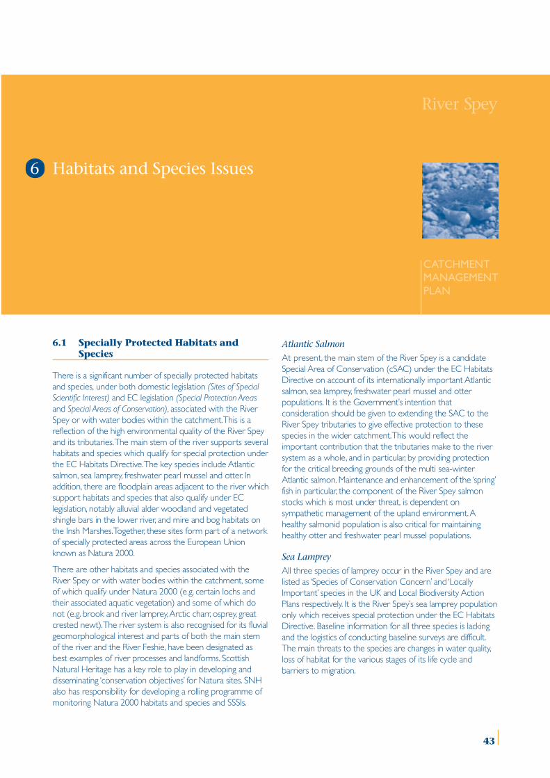
River Spey
CATCHMENTMANAGEMENTPLAN
Habitats and Species Issues
6.1 Specially Protected Habitats andSpecies
There is a significant number of specially protected habitatsand species, under both domestic legislation (Sites of SpecialScientific Interest) and EC legislation (Special Protection Areasand Special Areas of Conservation), associated with the RiverSpey or with water bodies within the catchment. This is areflection of the high environmental quality of the River Speyand its tributaries. The main stem of the river supports severalhabitats and species which qualify for special protection underthe EC Habitats Directive. The key species include Atlanticsalmon, sea lamprey, freshwater pearl mussel and otter. Inaddition, there are floodplain areas adjacent to the river whichsupport habitats and species that also qualify under EClegislation, notably alluvial alder woodland and vegetatedshingle bars in the lower river, and mire and bog habitats onthe Insh Marshes. Together, these sites form part of a networkof specially protected areas across the European Unionknown as Natura 2000.
There are other habitats and species associated with theRiver Spey or with water bodies within the catchment, someof which qualify under Natura 2000 (e.g. certain lochs andtheir associated aquatic vegetation) and some of which donot (e.g. brook and river lamprey, Arctic charr, osprey, greatcrested newt). The river system is also recognised for its fluvialgeomorphological interest and parts of both the main stemof the river and the River Feshie, have been designated asbest examples of river processes and landforms. ScottishNatural Heritage has a key role to play in developing anddisseminating ‘conservation objectives’ for Natura sites. SNHalso has responsibility for developing a rolling programme ofmonitoring Natura 2000 habitats and species and SSSIs.
Atlantic Salmon
At present, the main stem of the River Spey is a candidateSpecial Area of Conservation (cSAC) under the EC HabitatsDirective on account of its internationally important Atlanticsalmon, sea lamprey, freshwater pearl mussel and otterpopulations. It is the Government’s intention thatconsideration should be given to extending the SAC to theRiver Spey tributaries to give effective protection to thesespecies in the wider catchment. This would reflect theimportant contribution that the tributaries make to the riversystem as a whole, and in particular, by providing protectionfor the critical breeding grounds of the multi sea-winterAtlantic salmon. Maintenance and enhancement of the ‘spring’fish in particular, the component of the River Spey salmonstocks which is most under threat, is dependent onsympathetic management of the upland environment. Ahealthy salmonid population is also critical for maintaininghealthy otter and freshwater pearl mussel populations.
Sea Lamprey
All three species of lamprey occur in the River Spey and arelisted as ‘Species of Conservation Concern’ and ‘LocallyImportant’ species in the UK and Local Biodiversity ActionPlans respectively. It is the River Spey’s sea lamprey populationonly which receives special protection under the EC HabitatsDirective. Baseline information for all three species is lackingand the logistics of conducting baseline surveys are difficult.The main threats to the species are changes in water quality,loss of habitat for the various stages of its life cycle andbarriers to migration.
6
43
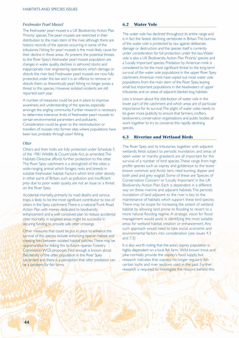
HABITATS AND SPECIES ISSUES
Freshwater Pearl Mussel
The freshwater pearl mussel is a UK Biodiversity Action Plan‘Priority’ species. The pearl mussels are restricted in theirdistribution to the main stem of the river, although there arehistoric records of the species occurring in some of thetributaries. Fishing for pearl mussels is the most likely cause fortheir decline in these areas. At present, the potential threatsto the River Spey’s freshwater pearl mussel population arechanges in water quality, declines in salmonid stocks andinappropriate river engineering operations which damage ordisturb the river bed. Freshwater pearl mussels are now fullyprotected under the law and it is an offence to remove ordisturb them, so theoretically pearl fishing no longer poses athreat to this species. However, isolated incidents are stillreported each year.
A number of measures could be put in place to improveawareness and understanding of the species, especiallyamongst the angling community. Further research is necessaryto determine tolerance limits of freshwater pearl mussels tocertain environmental parameters and pollutants.Consideration could be given to the reintroduction ortransfers of mussels into former sites where populations havebeen lost, probably through pearl fishing.
Otter
Otters and their holts are fully protected under Schedule 5of the 1981 Wildlife & Countryside Act, as amended. TheHabitats Directive affords further protection to the otter.The River Spey catchment is a stronghold of the otter, awide-ranging animal which forages, rests and breeds insuitable freshwater habitat. Factors which limit otter densityin other parts of Britain, such as pollution and insufficientprey due to poor water quality, are not an issue or a threaton the River Spey.
Accidental mortality, primarily by road deaths and varioustraps, is likely to be the most significant contributor to loss ofotters in the Spey catchment. There is a national Trunk RoadAction Plan with money dedicated to biodiversityenhancement and a well conceived plan to reduce accidentalotter mortality in targeted areas might be successful insecuring funding to provide safe otter crossings.
Other measures that could be put in place to enhance thesurvival of this species include enhancing riparian habitat andcreating links between isolated habitat patches. There may beopportunities for linking this to future riparian ForestryCommission WGS proposals. Not enough is known aboutthe density of the otter population in the River Speycatchment and there is a perception that otter predation canbe a problem for fish farms.
6.2 Water Vole
The water vole has declined throughout its entire range andis in fact the fastest declining vertebrate in Britain. The burrowof the water vole is protected by law against deliberatedamage or destruction and the species itself is currentlyunder consideration for full protection under the law. Watervole is also a UK Biodiversity Action Plan ‘Priority’ species anda ‘Locally Important’ species. Predation by American mink isconsidered to be the most significant threat to the long-termsurvival of the water vole populations in the upper River Speycatchment. American mink have wiped out most water volepopulations from the main stem of the River Spey, leavingsmall but important populations in the headwaters of uppertributaries and on areas of adjacent blanket bog habitats.
Less is known about the distribution of water vole in thelower part of the catchment and which areas are of particularimportance for its survival. The plight of water voles needs tobe given more publicity to ensure that farmers, crofters,landowners, conservation organisations and public bodies allwork together to try to conserve this rapidly decliningspecies.
6.3 Riverine and Wetland Birds
The River Spey and its tributaries, together with adjacentwetlands, fields subject to periodic inundation, and areas ofopen water or marshy grassland, are all important for thesurvival of a number of bird species. These range from highprofile species such as osprey and goldeneye to the lesserknown common and Arctic tern, reed bunting, dipper andboth pied and grey wagtail. Some of these are ‘Species ofConservation Concern’ or ‘Locally Important’ in the UKBiodiversity Action Plan. Each is dependent in a differentway on these riverine and adjacent habitats. The periodicinundation of land adjacent to the river is key to themaintenance of habitats which support these bird species.There may be scope for increasing the extent of wetlandhabitat by allowing land prone to flooding to revert to amore natural flooding regime. A strategic vision for floodmanagement would assist in identifying the most suitableareas for wetland habitat creation or enhancement. Anysuch approach would need to take social, economic andenvironmental factors into consideration (see issues 4.3and 7.3)
It is also worth noting that the area’s osprey population ishighly dependent on a local fish farm. Wild brown trout andpike normally provide the osprey’s food supply, butresearch indicates that ospreys no longer regularly fishcertain lochs and river sections used in the past. Furtherresearch is required to investigate the reasons behind this.
44
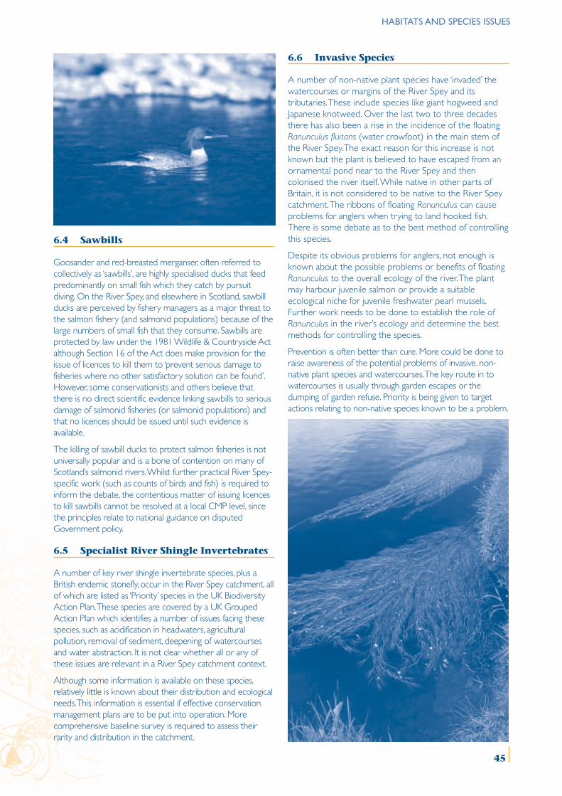
HABITATS AND SPECIES ISSUES
6.4 Sawbills
Goosander and red-breasted merganser, often referred tocollectively as ‘sawbills’, are highly specialised ducks that feedpredominantly on small fish which they catch by pursuitdiving. On the River Spey, and elsewhere in Scotland, sawbillducks are perceived by fishery managers as a major threat tothe salmon fishery (and salmonid populations) because of thelarge numbers of small fish that they consume. Sawbills areprotected by law under the 1981 Wildlife & Countryside Actalthough Section 16 of the Act does make provision for theissue of licences to kill them to ‘prevent serious damage tofisheries where no other satisfactory solution can be found’.However, some conservationists and others believe thatthere is no direct scientific evidence linking sawbills to seriousdamage of salmonid fisheries (or salmonid populations) andthat no licences should be issued until such evidence isavailable.
The killing of sawbill ducks to protect salmon fisheries is notuniversally popular and is a bone of contention on many ofScotland’s salmonid rivers. Whilst further practical River Spey-specific work (such as counts of birds and fish) is required toinform the debate, the contentious matter of issuing licencesto kill sawbills cannot be resolved at a local CMP level, sincethe principles relate to national guidance on disputedGovernment policy.
6.5 Specialist River Shingle Invertebrates
A number of key river shingle invertebrate species, plus aBritish endemic stonefly, occur in the River Spey catchment, allof which are listed as ‘Priority’ species in the UK BiodiversityAction Plan. These species are covered by a UK GroupedAction Plan which identifies a number of issues facing thesespecies, such as acidification in headwaters, agriculturalpollution, removal of sediment, deepening of watercoursesand water abstraction. It is not clear whether all or any ofthese issues are relevant in a River Spey catchment context.
Although some information is available on these species,relatively little is known about their distribution and ecologicalneeds. This information is essential if effective conservationmanagement plans are to be put into operation. Morecomprehensive baseline survey is required to assess theirrarity and distribution in the catchment.
6.6 Invasive Species
A number of non-native plant species have ‘invaded’ thewatercourses or margins of the River Spey and itstributaries. These include species like giant hogweed andJapanese knotweed. Over the last two to three decadesthere has also been a rise in the incidence of the floatingRanunculus fluitans (water crowfoot) in the main stem ofthe River Spey. The exact reason for this increase is notknown but the plant is believed to have escaped from anornamental pond near to the River Spey and thencolonised the river itself. While native in other parts ofBritain, it is not considered to be native to the River Speycatchment. The ribbons of floating Ranunculus can causeproblems for anglers when trying to land hooked fish.There is some debate as to the best method of controllingthis species.
Despite its obvious problems for anglers, not enough isknown about the possible problems or benefits of floatingRanunculus to the overall ecology of the river. The plantmay harbour juvenile salmon or provide a suitableecological niche for juvenile freshwater pearl mussels.Further work needs to be done to establish the role ofRanunculus in the river’s ecology and determine the bestmethods for controlling the species.
Prevention is often better than cure. More could be done toraise awareness of the potential problems of invasive, non-native plant species and watercourses. The key route in towatercourses is usually through garden escapes or thedumping of garden refuse. Priority is being given to targetactions relating to non-native species known to be a problem.
45
HABITATS AND SPECIES ISSUES
ISSUE 6.1 SPECIALLY PROTECTED HABITATS AND SPECIES
The River Spey cSAC currently does not include the tributaries which represent some of the most important areas of thecatchment for spawning Atlantic salmon. Sea lamprey and other lamprey species in the River Spey are poorly recorded makingit difficult to provide effective conservation management guidance to river managers.
The freshwater pearl mussel is a globally threatened species which has a stronghold population in the River Spey. Changes inwater quality, decline in salmonid stocks and inappropriate river engineering pose the most significant threats to this population.
Accidental mortality and fragmented, suitable riparian habitat are probably the two most significant limiting factors tootter distribution in the River Spey catchment.
MANAGEMENT OBJECTIVE 6.1
Conserve and enhance the Atlantic salmon, sea lamprey, freshwater pearl mussel and otter populations of the RiverSpey and its catchment.
No. Action Lead Others Timescale*
6.1.1 Consider the scientific case for, and carry out a public SNH Fishery proprietors Shortconsultation on, a possible extension to the River Spey cSAC SE Competent Authoritiesto include the tributaries of the catchment.
6.1.2 Develop and disseminate ‘conservation objectives’, and a SNH SFB Shortmonitoring programme, for specially protected habitats LBAPand species associated with the River Spey and other water FRSbodies within the catchment. SFCC
6.1.3 Develop efficient, cost-effective survey protocols for sea SNH SFB Shortlamprey and deep water freshwater pearl mussels and Fishery proprietorsproduce appropriate guidance on conservation management SEPAof these species.
6.1.4 Raise awareness amongst targeted local audiences of the LBAP SNH Shortimportant role of freshwater pearl mussel in the ecology and Fishery proprietorseconomy of the River Spey, and problems of illegal pearl fishing. Police
6.1.5 In light of further research on the ecological requirements SEPA SNH Shortof freshwater pearl mussel, and tolerance limits for pollutantssuch as copper, maintain high water quality standards andreview as necessary.
6.1.6 Consider freshwater pearl mussel reintroductions and/or SNH Cairngorms LBAP Longtransfers within the river system.
6.1.7 Assess the distribution of river engineering works and their SNH SFB Mediumrelationship to the distribution of designated features. Fishery Managers
6.1.8 Involve local communities in helping to identify otter accident LBAP SNH Short‘blackspots’, especially around bridges on the A9 and A95 Local Authoritiesand develop ‘otter friendly’ crossing places. Local communities
6.1.9 Collect and make available data on location of otter holts LBAP SNH Mediumand important feeding and resting areas to inform Competent Authoritiesland management decisions. Land managers
6.1.10 Encourage the establishment of good riparian habitat and LBAP SNH Mediumlinks between isolated habitat patches for otters. Forest of Spey
FCLand managers
FWAG
* Short, medium and long are defined by 1 to 3 years, 4 to 6 years and 6 years plus respectively. This definition for the timescaleapplies throughout the document.
46
HABITATS AND SPECIES ISSUES
ISSUE 6.2 WATER VOLE
Little is currently known about the distribution and abundance of the endangered water vole population in the RiverSpey catchment which is susceptible to predation by American mink.
MANAGEMENT OBJECTIVE 6.2
Conserve and enhance the fragmented and endangered water vole populations of the River Spey catchment basedon an improved understanding of their distribution.
No. Action Lead Others Timescale
6.2.1 Conduct a survey of water voles in lowland areas of SWT LBAP ShortMoray and assess the importance of the catchment as a SNHwhole for water voles.
6.2.2 Co-ordinate and instigate American mink trapping SWT SNH Shortprogrammes in target areas and at certain times of year. LBAPProvide support to trapping programme. Give advice on SFBbest practice including how to avoid a ‘by-catch’, SEPAotters in particular. Land managers
FWAG
6.2.3 Identify the remaining water vole areas and provide SWT/LBAP Local Authorities Shortadequate safeguards against future development on SNHor near those areas through the Local Planning process.
6.2.4 Develop and implement a strategic plan for the LBAP SWT Mediumconservation of water voles in the catchment area. SNHGuidance to land managers to be developed and issued. Land managersConsider how measures for water voles might be better SEPAbuilt into agri-environment schemes. SFB
SEERADFWAG
6.2.5 Evaluate the case for reintroduction of water voles into SWT LBAP Longsuitable areas of habitat within the catchment. SNH
Land managers
47
HABITATS AND SPECIES ISSUES
ISSUE 6.3 RIVERINE AND WETLAND BIRDS
A number of bird species depend on the rivers or wetlands. Some of them, of local or national importance, aredistributed throughout the catchment but information on population numbers is patchy. Species include goldeneye,whooper swans, osprey, Slavonian grebes, wagtails, dippers and reed buntings.
MANAGEMENT OBJECTIVE 6.3
Conserve and enhance the riverine bird populations of the River Spey catchment based on an improvedunderstanding of their distribution.
No. Action Lead Others Timescale
6.3.1 Raise awareness of habitat and conservation management RSPB LBAP Shortrequirements of bird species dependent on the river system SNHand associated freshwater bodies for their survival. Land managers
FWAG
6.3.2 Provide nest boxes for goldeneye and monitor their use Goldeneye RSPB Shortto improve effectiveness of the project. Study Group LBAP
SNH
6.3.3 Improve the baseline distribution knowledge of riverine RSPB LBAP Mediumbirds generally in the River Spey catchment, but particularly SNHin Moray.
6.3.4 Develop and promote a strategy to protect riverine bird RSPB LBAP Mediumspecies from disturbance during the breeding season. SNH
Land managers
6.3.5 Investigate use of lochs and rivers by hunting osprey Highland Foundation SNH Shortfor comparison with fish farm use. for Wildlife
ISSUE 6.4 SAWBILLS
There is divided opinion as to whether sawbill ducks (red-breasted merganser and goosander) cause serious economicdamage to salmon and sea trout fisheries and also how to deal with this predator-prey relationship (see issue 5.1).
MANAGEMENT OBJECTIVE 6.4
Resolve the contentious issue of the management of sawbill ducks.
No. Action Lead Others Timescale
6.4.1 Seek guidance from SEERAD on what evidence and SCSG Shortcircumstances constitute ‘serious damage’ (by sawbills)to salmonid fisheries.
6.4.2 Broker a consensus between stakeholders on the SCSG FRS Mediumappropriate management of sawbills within the Fishing interestscatchment. RSPB
Cairngorms LBAP
6.4.3 Continue to count, and improve understanding of, SFB Land managers Shortthe use of the river system by sawbills, including Cairngorms LBAP RSPBtheir impact on fish species.
48
HABITATS AND SPECIES ISSUES
ISSUE 6.5 SPECIALIST RIVER SHINGLE INVERTEBRATES
Lack of knowledge and understanding of the distribution and ecological requirements render a number of specialist rivershingle invertebrate species, some of them nationally rare, vulnerable to environmental and land-use changes.
MANAGEMENT OBJECTIVE 6.5
Conserve and enhance the specialist river shingle invertebrate populations of the River Spey catchment based on animproved understanding of their distribution.
No. Action Lead Others Timescale
6.5.1 Undertake appropriate research/survey to fill gaps in SNH/SEPA LBAP Mediumbaseline knowledge of the presence and distribution SEPAof these species within the catchment.
6.5.2 Assess the importance of the River Spey catchment SNH LBAP Mediumfor these species and relevant management issues. SEPA
6.5.3 Raise awareness of management issues related to the LBAP SNH Mediumimportant and rare river shingle invertebrates with SEPAriver managers. Land managers
FWAG
ISSUE 6.6 INVASIVE SPECIES
Non-native, invasive species have affected parts of the River Spey and other watercourses in the catchment, with one plantspecies, Ranunculus fluitans, in particular causing problems for anglers.
Not enough is known about the impact of these species on the ecology of the watercourses and best means ofcontrolling them.
MANAGEMENT OBJECTIVE 6.6.
Develop, promote and support a strategic approach towards the control of invasive riverine species.
No. Action Lead Others Timescale
6.6.1 Investigate the possible cause of the spread of SNH Land managers ShortRanunculus fluitans in the River Spey and develop SEPAprotocols for its mechanical control, based on an SFBunderstanding of its ecological role in the river system.
6.6.2 Raise awareness, amongst local garden centres and LBAP SNH Shortthrough the media, of the problems associated with SEPAinvasive, non-native species escaping into watercourses. SFB
Local AuthoritiesLocal communities
6.6.3 Assess distribution and impact of invasive non-native Moray Council Land managers Mediumspecies in the lower River Spey catchment and carry SEPAout a feasibility study for their control NE LBAP
49
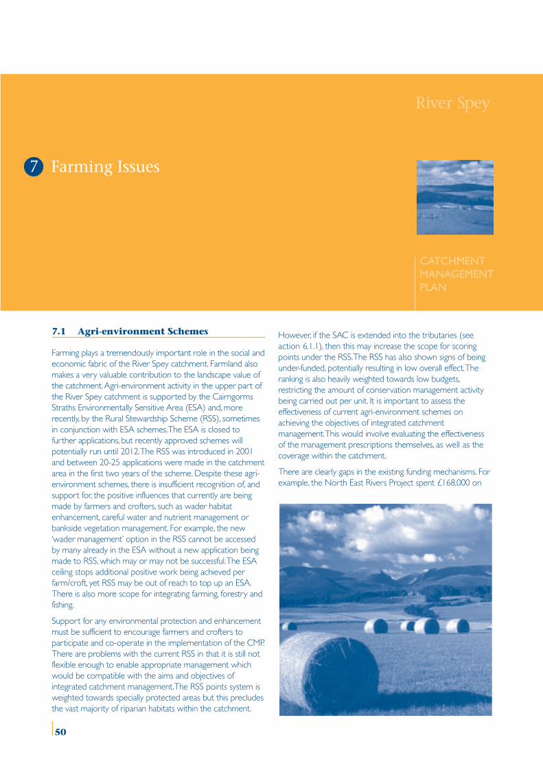
7.1 Agri-environment Schemes
Farming plays a tremendously important role in the social andeconomic fabric of the River Spey catchment. Farmland alsomakes a very valuable contribution to the landscape value ofthe catchment. Agri-environment activity in the upper part ofthe River Spey catchment is supported by the CairngormsStraths Environmentally Sensitive Area (ESA) and, morerecently, by the Rural Stewardship Scheme (RSS), sometimesin conjunction with ESA schemes. The ESA is closed tofurther applications, but recently approved schemes willpotentially run until 2012. The RSS was introduced in 2001and between 20-25 applications were made in the catchmentarea in the first two years of the scheme. Despite these agri-environment schemes, there is insufficient recognition of, andsupport for, the positive influences that currently are beingmade by farmers and crofters, such as wader habitatenhancement, careful water and nutrient management orbankside vegetation management. For example, the new‘wader management’ option in the RSS cannot be accessedby many already in the ESA without a new application beingmade to RSS, which may or may not be successful. The ESAceiling stops additional positive work being achieved perfarm/croft, yet RSS may be out of reach to top up an ESA.There is also more scope for integrating farming, forestry andfishing.
Support for any environmental protection and enhancementmust be sufficient to encourage farmers and crofters toparticipate and co-operate in the implementation of the CMP.There are problems with the current RSS in that it is still notflexible enough to enable appropriate management whichwould be compatible with the aims and objectives ofintegrated catchment management. The RSS points system isweighted towards specially protected areas but this precludesthe vast majority of riparian habitats within the catchment.
However, if the SAC is extended into the tributaries (seeaction 6.1.1), then this may increase the scope for scoringpoints under the RSS. The RSS has also shown signs of beingunder-funded, potentially resulting in low overall effect. Theranking is also heavily weighted towards low budgets,restricting the amount of conservation management activitybeing carried out per unit. It is important to assess theeffectiveness of current agri-environment schemes onachieving the objectives of integrated catchmentmanagement. This would involve evaluating the effectivenessof the management prescriptions themselves, as well as thecoverage within the catchment.
There are clearly gaps in the existing funding mechanisms. Forexample, the North East Rivers Project spent £168,000 on
River Spey
CATCHMENTMANAGEMENTPLAN
Farming Issues7
50
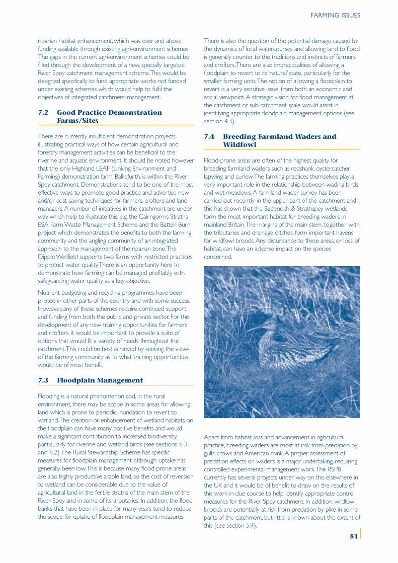
riparian habitat enhancement, which was over and abovefunding available through existing agri-environment schemes.The gaps in the current agri-environment schemes could befilled through the development of a new, specially targeted,River Spey catchment management scheme. This would bedesigned specifically to fund appropriate works not fundedunder existing schemes which would help to fulfil theobjectives of integrated catchment management.
7.2 Good Practice DemonstrationFarms/Sites
There are currently insufficient demonstration projectsillustrating practical ways of how certain agricultural andforestry management activities can be beneficial to theriverine and aquatic environment. It should be noted howeverthat the only Highland LEAF (Linking Environment andFarming) demonstration farm, Balliefurth, is within the RiverSpey catchment. Demonstrations tend to be one of the mosteffective ways to promote good practice and advertise newand/or cost-saving techniques for farmers, crofters and landmanagers. A number of initiatives in the catchment are underway which help to illustrate this, e.g. the Cairngorms StrathsESA Farm Waste Management Scheme and the Batten Burnproject which demonstrates the benefits to both the farmingcommunity and the angling community of an integratedapproach to the management of the riparian zone. TheDipple Wellfield supports two farms with restricted practicesto protect water quality. There is an opportunity here todemonstrate how farming can be managed profitably withsafeguarding water quality as a key objective.
Nutrient budgeting and recycling programmes have beenpiloted in other parts of the country and with some success.However, any of these schemes require continued supportand funding from both the public and private sector. For thedevelopment of any new training opportunities for farmersand crofters, it would be important to provide a suite ofoptions that would fit a variety of needs throughout thecatchment. This could be best achieved by seeking the viewsof the farming community as to what training opportunitieswould be of most benefit.
7.3 Floodplain Management
Flooding is a natural phenomenon and, in the ruralenvironment, there may be scope in some areas for allowingland which is prone to periodic inundation to revert towetland. The creation or enhancement of wetland habitats onthe floodplain can have many positive benefits and wouldmake a significant contribution to increased biodiversity,particularly for riverine and wetland birds (see sections 6.3and 8.2). The Rural Stewardship Scheme has specificmeasures for floodplain management, although uptake hasgenerally been low. This is because many flood-prone areasare also highly productive arable land, so the cost of reversionto wetland can be considerable due to the value ofagricultural land in the fertile straths of the main stem of theRiver Spey and in some of its tributaries. In addition, the floodbanks that have been in place for many years tend to reducethe scope for uptake of floodplain management measures.
There is also the question of the potential damage caused bythe dynamics of local watercourses and allowing land to floodis generally counter to the traditions and instincts of farmersand crofters. There are also impracticalities of allowing afloodplain to revert to its ‘natural’ state, particularly for thesmaller farming units. The notion of allowing a floodplain torevert is a very sensitive issue, from both an economic andsocial viewpoint. A strategic vision for flood management atthe catchment or sub-catchment scale would assist inidentifying appropriate floodplain management options (seesection 4.3).
7.4 Breeding Farmland Waders andWildfowl
Flood-prone areas are often of the highest quality forbreeding farmland waders such as redshank, oystercatcher,lapwing and curlew. The farming practices themselves play avery important role in the relationship between wading birdsand wet meadows. A farmland wader survey has beencarried out recently in the upper part of the catchment andthis has shown that the Badenoch & Strathspey wetlandsform the most important habitat for breeding waders inmainland Britain. The margins of the main stem, together withthe tributaries and drainage ditches, form important havensfor wildfowl broods. Any disturbance to these areas, or loss ofhabitat, can have an adverse impact on the speciesconcerned.
Apart from habitat loss and advancement in agriculturalpractice, breeding waders are most at risk from predation bygulls, crows and American mink. A proper assessment ofpredation effects on waders is a major undertaking, requiringcontrolled experimental management work. The RSPBcurrently has several projects under way on this elsewhere inthe UK and it would be of benefit to draw on the results ofthis work in due course to help identify appropriate controlmeasures for the River Spey catchment. In addition, wildfowlbroods are potentially at risk from predation by pike in someparts of the catchment, but little is known about the extent ofthis (see section 5.4).
FARMING ISSUES
51
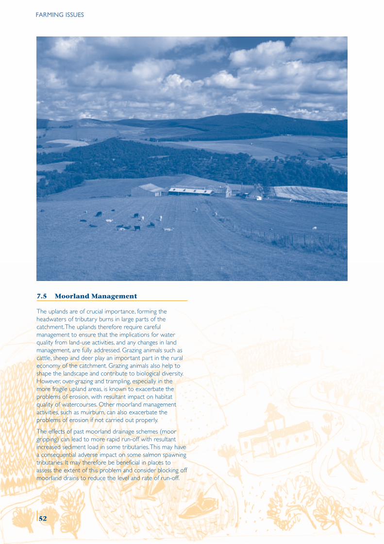
7.5 Moorland Management
The uplands are of crucial importance, forming theheadwaters of tributary burns in large parts of thecatchment. The uplands therefore require carefulmanagement to ensure that the implications for waterquality from land-use activities, and any changes in landmanagement, are fully addressed. Grazing animals such ascattle, sheep and deer play an important part in the ruraleconomy of the catchment. Grazing animals also help toshape the landscape and contribute to biological diversity.However, over-grazing and trampling, especially in themore fragile upland areas, is known to exacerbate theproblems of erosion, with resultant impact on habitatquality of watercourses. Other moorland managementactivities, such as muirburn, can also exacerbate theproblems of erosion if not carried out properly.
The effects of past moorland drainage schemes (moorgripping) can lead to more rapid run-off with resultantincreased sediment load in some tributaries. This may havea consequential adverse impact on some salmon spawningtributaries. It may therefore be beneficial in places toassess the extent of this problem and consider blocking offmoorland drains to reduce the level and rate of run-off.
FARMING ISSUES
52
ISSUE 7.1 AGRI-ENVIRONMENT SCHEMES
There is insufficient funding and flexibility within the current agri-environment schemes to provide the necessary support for anumber of positive management activities that could potentially be undertaken by farmers and crofters to improve waterquality and riparian and wetland habitat.
The Rural Stewardship Scheme points system is biased towards specially protected areas which automatically precludes thevast majority of riparian habitat within the River Spey catchment.
MANAGEMENT OBJECTIVE 7.1
Promote, through existing or new agri-environment and other schemes, agricultural practices which benefit waterquality and riparian and wetland habitats.
No. Action Lead Others Timescale*
7.1.1 Assess the ability of current agri-environment schemes to FWAG/ Farmers & Shortcontribute to integrated catchment management objectives. SEERAD crofters
SNHSFB
SEPANFUS
7.1.2 Lobby for flexibility and increased funding in the existing Farmers & SCSG Shortagri-environment schemes to enable appropriate crofters NFUSmanagement to be carried out to address the objectivesfor integrated catchment management (including provisionfor the support of local path networks).
7.1.3 Lobby for RSS points to be awarded for appropriate Farmers & SCSG Shortworks within the River Spey catchment as being crofters NFUSequivalent to a national designation.
7.1.4 Develop a possible new River Spey ‘catchment SCSG FWAG Shortmanagement scheme’ to broaden the scope for positive Farmers &agri-environment and other initiatives. crofters
NFUS
* Short, medium and long are defined by 1 to 3 years, 4 to 6 years and 6 years plus respectively. This definition for thetimescale applies throughout the document.
FARMING ISSUES
53
FARMING ISSUES
ISSUE 7.2 GOOD PRACTICE DEMONSTRATION FARMS/SITES
Opportunities for developing best practice management demonstrations on farms/sites are currently under-exploitedand under-resourced.
MANAGEMENT OBJECTIVE 7.2
Develop and promote demonstrations of good farming practice which contribute to the aims and objectives ofintegrated catchment management.
No. Action Lead Others Timescale
7.2.1 Encourage and support any pilot project farms to become SCSG Farmers & Short‘demonstration farms’ to highlight good practice, e.g. role croftersof woodland, reed beds, wader habitat management, water FWAGmargin management, grazing or access. Particularly organise SEPAan annual demonstration event. SEERAD
Crown Estate
7.2.2 Create logo for farms to advertise their involvement, to give SCSG Farmers & Shortthe project an identity and to encourage other farmers/groups croftersto visit. SEERAD
FWAG
7.2.3 Support smaller demonstration projects such as SEPA’s SCSG Farmers & ShortHabitat Enhancement Initiatives and the Batten Burn project. crofters
SEERADSEPA
FWAGSFB
7.2.4 Explore opportunities for training and publicity to Lantra Farmers & Shortdisseminate advice and promote best practice on habitat FWAG croftersmanagement, waste management, nutrient budgeting, etc. SEERAD
SEPA
54
ISSUE 7.3 FLOODPLAIN MANAGEMENT
Areas that are prone to periodic inundation are often of relatively high agricultural value and simply letting them revertto wetland is not always an option for social, economic and practical reasons. Such areas are, however, often of highnature conservation value.
MANAGEMENT OBJECTIVE 7.3
Investigate the scope for management of flooding and the river system by the use of natural floodplains.
No. Action Lead Others Timescale
7.3.1 Consider establishing a pilot flooding scheme in a SCSG Land managers Shorttributary or sub-tributary catchment with appropriate SEPAfunding. Pilot should include an assessment of the MLURIbenefit of flooding for conservation interest. Local communities
FWAG
7.3.2 Identify the potential floodplain area to provide flood Highland Council Land managers Mediumalleviation remote from settlements. Moray Council SEPA
SEPA MLURILocal communities
7.3.3 Carry out an appraisal of the full cost (economic and SCSG Land Managers Mediumsocial) of an increase in the use of natural floodplains. Local communities
FARMING ISSUES
55
FARMING ISSUES
ISSUE 7.4 BREEDING FARMLAND WADERS AND WILDFOWL
Farmland and water margins provide a significant proportion of the catchment’s essential wader and wildfowl habitat, butinformation on the extent of this is currently poor.
The issue of predation of breeding wader and wildfowl broods by gulls, crows, American mink and pike is complex andany management prescriptions will need to be based on the results of national research projects.
MANAGEMENT OBJECTIVE 7.4
Assess the nature conservation value of breeding waders and wildfowl on farmland and water margins within thecatchment and promote ‘wader/wildfowl friendly’ management practices.
No. Action Lead Others Timescale
7.4.1 Extend farmland waders survey to wider RSPB SNH Shortcatchment and initiate a monitoring programme. Land managers
LBAP
7.4.2 Identify important areas for wading birds and promote RSPB NFUS Shortbest practice management to farmers/crofters and other FWAG MLURIland managers. SNH
Land managersLBAP
7.4.3 Raise awareness of the issue of impact of predators FWAG NFUS Medium(including gulls, crows, American mink and pike) on LBAP MLURIbreeding waders and wildfowl. RSPB
SNHLand managers
LBAP
7.4.4 Draw on the results of national research projects to FWAG NFUS Mediumdevelop and implement an appropriate predator control LBAP MLURIproject to protect breeding waders and wildfowl. RSPB
SNHLand managers
LBAP
56
ISSUE 7.5 MOORLAND MANAGEMENT
Grazing is a useful management tool, but inappropriate grazing in some of the more fragile upland habitats can exacerbate theproblems of erosion with resultant adverse impacts on water quality.
Past moorland drainage schemes may have an adverse impact on the quality of salmon spawning habitat in some areas.
MANAGEMENT OBJECTIVE 7.5
Raise awareness of, and promote, moorland management practices which help to safeguard water quality and riverhabitats.
No. Action Lead Others Timescale
7.5.1 Raise awareness of the importance of upland tributaries Moorland Forum Land managers Mediumand promote best practice in moorland management Farmers &(including demonstration sites) insofar as it relates to crofterswatercourses and land drainage. Crown Estate
SNHSEPA
7.5.2 Assess the extent of past moorland drainage as an SFB SNH Mediumissue for spawning salmon habitat and identify site(s) Land managersfor remedial action.
FARMING ISSUES
57
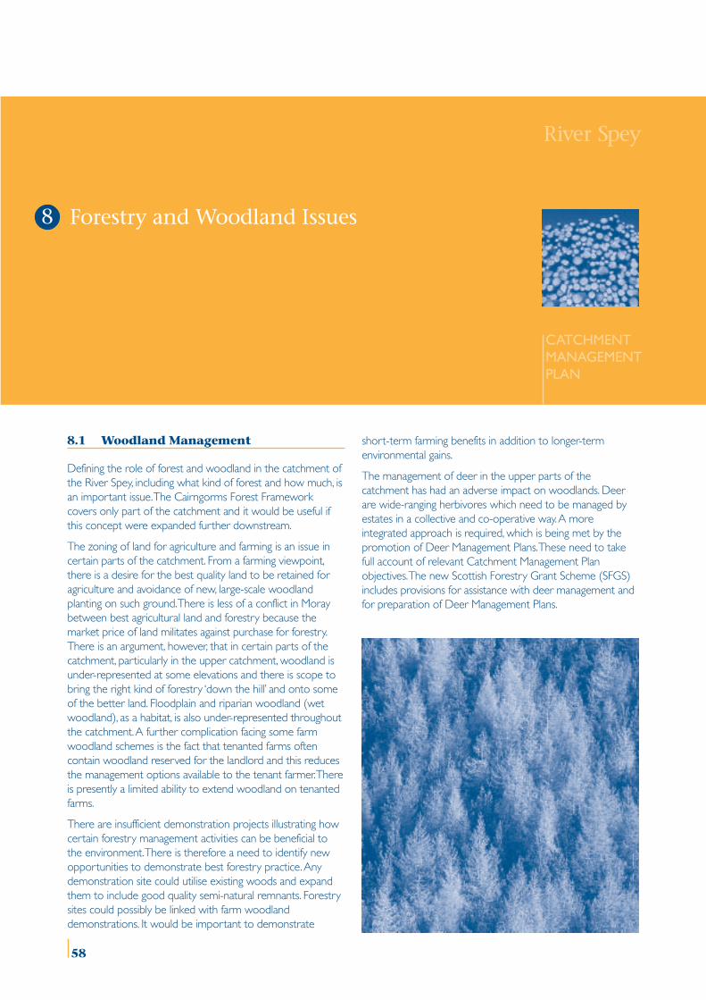
8.1 Woodland Management
Defining the role of forest and woodland in the catchment ofthe River Spey, including what kind of forest and how much, isan important issue. The Cairngorms Forest Frameworkcovers only part of the catchment and it would be useful ifthis concept were expanded further downstream.
The zoning of land for agriculture and farming is an issue incertain parts of the catchment. From a farming viewpoint,there is a desire for the best quality land to be retained foragriculture and avoidance of new, large-scale woodlandplanting on such ground. There is less of a conflict in Moraybetween best agricultural land and forestry because themarket price of land militates against purchase for forestry.There is an argument, however, that in certain parts of thecatchment, particularly in the upper catchment, woodland isunder-represented at some elevations and there is scope tobring the right kind of forestry ‘down the hill’ and onto someof the better land. Floodplain and riparian woodland (wetwoodland), as a habitat, is also under-represented throughoutthe catchment. A further complication facing some farmwoodland schemes is the fact that tenanted farms oftencontain woodland reserved for the landlord and this reducesthe management options available to the tenant farmer. Thereis presently a limited ability to extend woodland on tenantedfarms.
There are insufficient demonstration projects illustrating howcertain forestry management activities can be beneficial tothe environment. There is therefore a need to identify newopportunities to demonstrate best forestry practice. Anydemonstration site could utilise existing woods and expandthem to include good quality semi-natural remnants. Forestrysites could possibly be linked with farm woodlanddemonstrations. It would be important to demonstrate
short-term farming benefits in addition to longer-termenvironmental gains.
The management of deer in the upper parts of thecatchment has had an adverse impact on woodlands. Deerare wide-ranging herbivores which need to be managed byestates in a collective and co-operative way. A moreintegrated approach is required, which is being met by thepromotion of Deer Management Plans. These need to takefull account of relevant Catchment Management Planobjectives. The new Scottish Forestry Grant Scheme (SFGS)includes provisions for assistance with deer management andfor preparation of Deer Management Plans.
River Spey
CATCHMENTMANAGEMENTPLAN
Forestry and Woodland Issues8
58
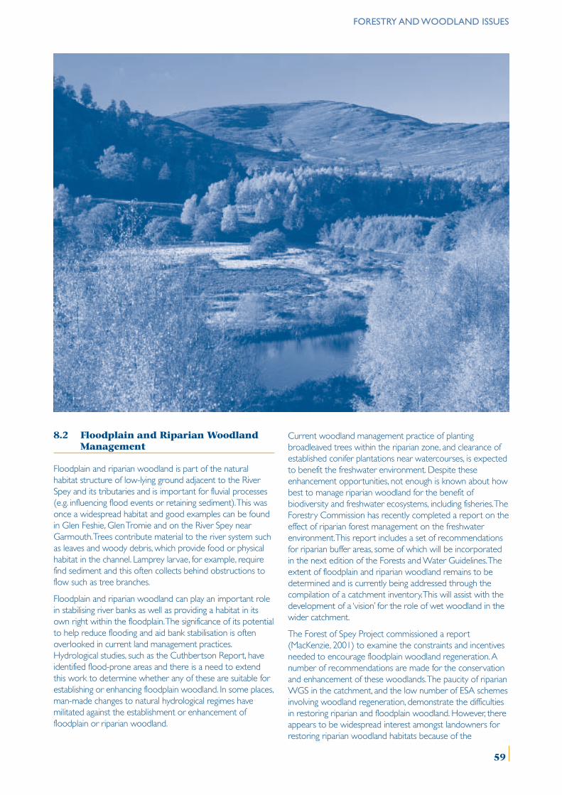
8.2 Floodplain and Riparian WoodlandManagement
Floodplain and riparian woodland is part of the naturalhabitat structure of low-lying ground adjacent to the RiverSpey and its tributaries and is important for fluvial processes(e.g. influencing flood events or retaining sediment). This wasonce a widespread habitat and good examples can be foundin Glen Feshie, Glen Tromie and on the River Spey nearGarmouth. Trees contribute material to the river system suchas leaves and woody debris, which provide food or physicalhabitat in the channel. Lamprey larvae, for example, requirefind sediment and this often collects behind obstructions toflow such as tree branches.
Floodplain and riparian woodland can play an important rolein stabilising river banks as well as providing a habitat in itsown right within the floodplain. The significance of its potentialto help reduce flooding and aid bank stabilisation is oftenoverlooked in current land management practices.Hydrological studies, such as the Cuthbertson Report, haveidentified flood-prone areas and there is a need to extendthis work to determine whether any of these are suitable forestablishing or enhancing floodplain woodland. In some places,man-made changes to natural hydrological regimes havemilitated against the establishment or enhancement offloodplain or riparian woodland.
Current woodland management practice of plantingbroadleaved trees within the riparian zone, and clearance ofestablished conifer plantations near watercourses, is expectedto benefit the freshwater environment. Despite theseenhancement opportunities, not enough is known about howbest to manage riparian woodland for the benefit ofbiodiversity and freshwater ecosystems, including fisheries. TheForestry Commission has recently completed a report on theeffect of riparian forest management on the freshwaterenvironment. This report includes a set of recommendationsfor riparian buffer areas, some of which will be incorporatedin the next edition of the Forests and Water Guidelines. Theextent of floodplain and riparian woodland remains to bedetermined and is currently being addressed through thecompilation of a catchment inventory. This will assist with thedevelopment of a ‘vision’ for the role of wet woodland in thewider catchment.
The Forest of Spey Project commissioned a report(MacKenzie, 2001) to examine the constraints and incentivesneeded to encourage floodplain woodland regeneration. Anumber of recommendations are made for the conservationand enhancement of these woodlands. The paucity of riparianWGS in the catchment, and the low number of ESA schemesinvolving woodland regeneration, demonstrate the difficultiesin restoring riparian and floodplain woodland. However, thereappears to be widespread interest amongst landowners forrestoring riparian woodland habitats because of the
FORESTRY AND WOODLAND ISSUES
59
FORESTRY AND WOODLAND ISSUES
acknowledged benefits to fishing and water quality, preventionof bank erosion and livestock shelter. The two mainconstraints that limit further action are the financial costsinvolved in restoring riparian woodland and the loss ofgrazing land, especially on the floodplain. The new SFGS,however, offers specific support at enhanced rates fordevelopment of new riparian woodland and for managementof existing riparian woodland. One of the conditions ofreceiving the enhanced rate of grant is that woodlandmanagement or expansion proposals should reflect theobjectives of any Catchment Management Plan.
As well as playing a role in stabilising river banks, floodplainand riparian woodland can form an important buffer ornutrient ‘sink’ for agricultural run-off. It also provides a filteringmechanism for removing sediment. Several studies havebeen conducted outwith the UK on the benefits of riparianwoodland for intercepting pollutants draining from adjacentagricultural land. There would be some merit in conducting astudy to see how these results might relate to conditions inthe River Spey catchment.
8.3 Tree Species Under Threat
The health and status of a number of native tree species iscausing concern, either because of disease or associatedproblems, or generally through pressures on abundance anddistribution through competing land-use management. Thetree species of most concern include aspen, alder (die-back),willow (in the upper catchment), wych elm (LBAP species)and ash.
60
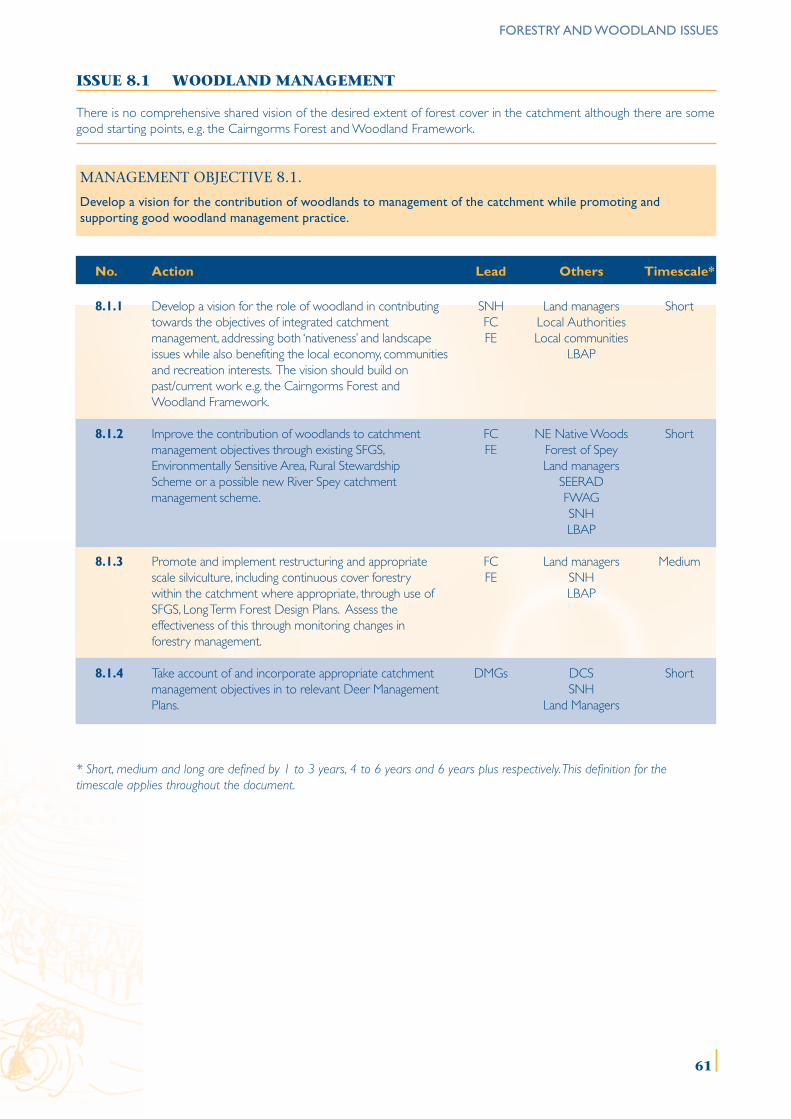
FORESTRY AND WOODLAND ISSUES
61
ISSUE 8.1 WOODLAND MANAGEMENT
There is no comprehensive shared vision of the desired extent of forest cover in the catchment although there are somegood starting points, e.g. the Cairngorms Forest and Woodland Framework.
MANAGEMENT OBJECTIVE 8.1.
Develop a vision for the contribution of woodlands to management of the catchment while promoting andsupporting good woodland management practice.
No. Action Lead Others Timescale*
8.1.1 Develop a vision for the role of woodland in contributing SNH Land managers Shorttowards the objectives of integrated catchment FC Local Authoritiesmanagement, addressing both ‘nativeness’ and landscape FE Local communitiesissues while also benefiting the local economy, communities LBAPand recreation interests. The vision should build onpast/current work e.g. the Cairngorms Forest andWoodland Framework.
8.1.2 Improve the contribution of woodlands to catchment FC NE Native Woods Shortmanagement objectives through existing SFGS, FE Forest of SpeyEnvironmentally Sensitive Area, Rural Stewardship Land managersScheme or a possible new River Spey catchment SEERADmanagement scheme. FWAG
SNHLBAP
8.1.3 Promote and implement restructuring and appropriate FC Land managers Mediumscale silviculture, including continuous cover forestry FE SNHwithin the catchment where appropriate, through use of LBAPSFGS, Long Term Forest Design Plans. Assess theeffectiveness of this through monitoring changes inforestry management.
8.1.4 Take account of and incorporate appropriate catchment DMGs DCS Shortmanagement objectives in to relevant Deer Management SNHPlans. Land Managers
* Short, medium and long are defined by 1 to 3 years, 4 to 6 years and 6 years plus respectively. This definition for thetimescale applies throughout the document.
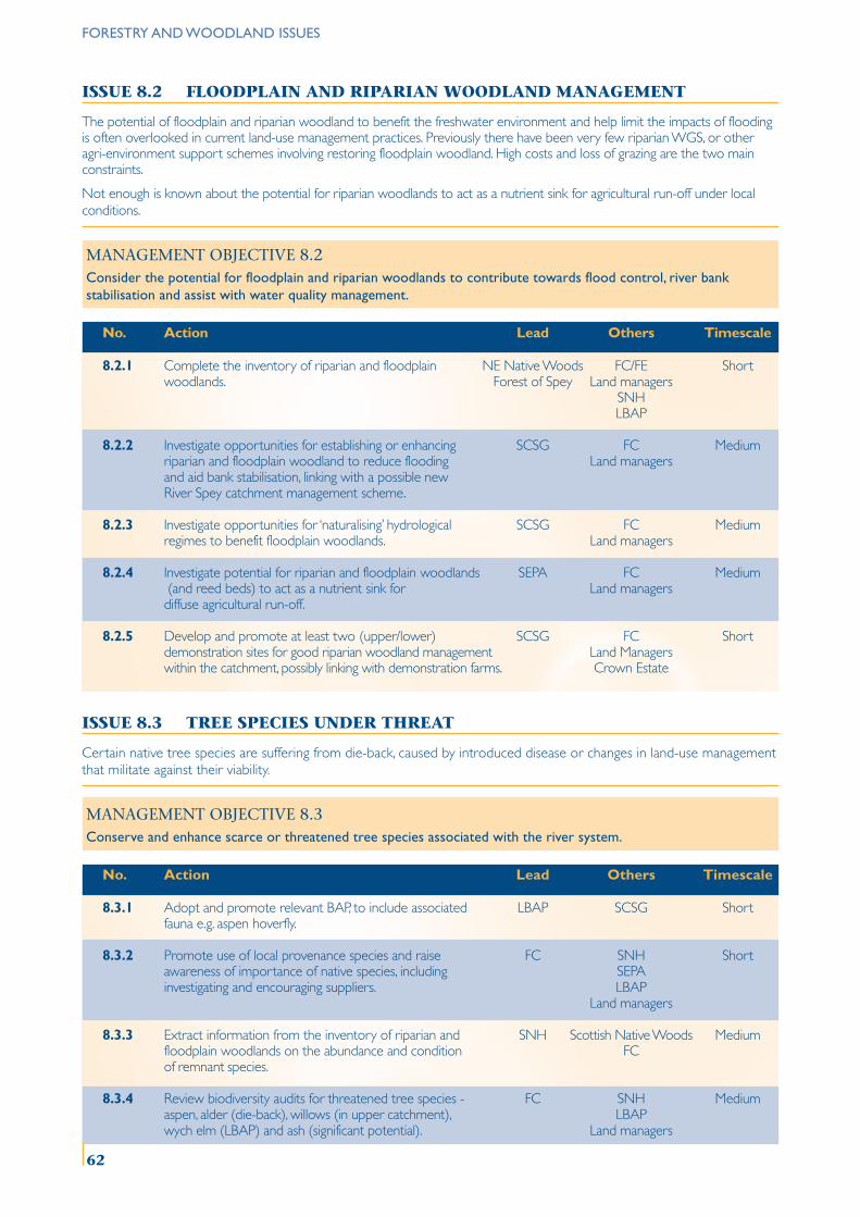
ISSUE 8.2 FLOODPLAIN AND RIPARIAN WOODLAND MANAGEMENT
The potential of floodplain and riparian woodland to benefit the freshwater environment and help limit the impacts of floodingis often overlooked in current land-use management practices. Previously there have been very few riparian WGS, or otheragri-environment support schemes involving restoring floodplain woodland. High costs and loss of grazing are the two mainconstraints.
Not enough is known about the potential for riparian woodlands to act as a nutrient sink for agricultural run-off under localconditions.
MANAGEMENT OBJECTIVE 8.2Consider the potential for floodplain and riparian woodlands to contribute towards flood control, river bankstabilisation and assist with water quality management.
No. Action Lead Others Timescale
8.2.1 Complete the inventory of riparian and floodplain NE Native Woods FC/FE Shortwoodlands. Forest of Spey Land managers
SNHLBAP
8.2.2 Investigate opportunities for establishing or enhancing SCSG FC Mediumriparian and floodplain woodland to reduce flooding Land managersand aid bank stabilisation, linking with a possible newRiver Spey catchment management scheme.
8.2.3 Investigate opportunities for ‘naturalising’ hydrological SCSG FC Mediumregimes to benefit floodplain woodlands. Land managers
8.2.4 Investigate potential for riparian and floodplain woodlands SEPA FC Medium (and reed beds) to act as a nutrient sink for Land managersdiffuse agricultural run-off.
8.2.5 Develop and promote at least two (upper/lower) SCSG FC Shortdemonstration sites for good riparian woodland management Land Managerswithin the catchment, possibly linking with demonstration farms. Crown Estate
ISSUE 8.3 TREE SPECIES UNDER THREAT
Certain native tree species are suffering from die-back, caused by introduced disease or changes in land-use managementthat militate against their viability.
MANAGEMENT OBJECTIVE 8.3Conserve and enhance scarce or threatened tree species associated with the river system.
No. Action Lead Others Timescale
8.3.1 Adopt and promote relevant BAP, to include associated LBAP SCSG Shortfauna e.g. aspen hoverfly.
8.3.2 Promote use of local provenance species and raise FC SNH Shortawareness of importance of native species, including SEPAinvestigating and encouraging suppliers. LBAP
Land managers
8.3.3 Extract information from the inventory of riparian and SNH Scottish Native Woods Mediumfloodplain woodlands on the abundance and condition FCof remnant species.
8.3.4 Review biodiversity audits for threatened tree species - FC SNH Mediumaspen, alder (die-back), willows (in upper catchment), LBAPwych elm (LBAP) and ash (significant potential). Land managers
FORESTRY AND WOODLAND ISSUES
62

River Spey
CATCHMENTMANAGEMENTPLAN
9.1 Future Housing Development in theCatchment
The Badenoch & Strathspey Local Plan (adopted in 1997)identifies housing land for about 3000 new houses over a 15year period, including a new settlement at Cambusmore thatwill require prior Environmental Assessment. Aviemore itself isexpected to see major housing and tourist-relateddevelopments in the short term. The Moray Local Plan(adopted in 2000) identifies housing land for about 470houses up to 2007. The principal settlements for expansionare Fochabers, Dufftown, Aberlour and Rothes. Housingforecasts will be reviewed when Local Plans are next revised.
Water supply and wastewater treatment are under constantreview by Scottish Water and the projected increases indemand need to be considered carefully in the context of thecatchment’s water resource capability (see section 4.7). SW iscurrently investing in upgrades in a number of WaterTreatment Works (WTW), including a major change to theLoch Einich supply network to make better use of the waterfrom this source. This is a sensitive issue given the location ofthe loch within the National Park, particularly in terms ofpossible impact on recreation and natural heritage interests.Upgrading the Einich supply should meet water demand to2016, but beyond this, either another source will be needed,or water will have to be used more efficiently (includingleakage management).
A more integrated method of working between planningauthorities, SW and SEPA is necessary to ensure that thecapacity of both the water supply network, and thewastewater system, can accommodate future housing landallocations and industrial developments. Local HousingDevelopment Forums can assist in this regard. Furthermore, itis important to link environmental capacity with the water
resource. This would help to inform decisions on the longer-term scope for further development. It would also serve toindicate whether, in order to accommodate futuredevelopment, water efficiency measures are necessary.
Housing proposals should incorporate a Sustainable UrbanDrainage System (SUDS) and there is a need to enhance theknowledge of SUDS among developers and advisers. Waterand waste efficiency should be tackled through a numberof means, from educational initiatives which encouragedomestic and business users not to dispose of undesirablematerials in the wastewater treatment system, e.g. oils,greases, sanitary items, through to the adoption of some
Community Economic DevelopmentIssues
9
63
COMMUNITY ECONOMIC DEVELOPMENT ISSUES
sort of water efficiency rating through the Building Controlprocess. Scottish Water is building on existing educationalinitiatives and will be re-launching ‘Bag It & Bin It’ in 2003, acampaign aimed at raising awareness of what not todispose of through the waste water treatment system.
9.2 Private Water Supply and Treatment
There are numerous examples of private water supplies andwastewater treatment, ranging in size from individual wellsand septic tanks, to settlements which may be networkedthrough some form of private water supply and wastewatertreatment system. From time to time these private suppliesand wastewater treatment facilities can give rise to problems,particularly where there are accumulations of housing onvery free draining soils. Under such conditions, percolationcan take place relatively quickly, thus risking effluent andnutrients passing into the water system insufficiently diluted.An example of where there are particular problems is thewater and wastewater treatment facilities at Glenmore, whichare owned and maintained by Forest Enterprise. This servesall of Glenmore village (except Glenmore Lodge which has itsown water supply) and costs are recovered pro rata by FE.Glenmore has both permanent and recreationalaccommodation. The systems operate at close to maximumcapacity during the summer months, and while sewageeffluent currently meets discharge consent levels set by SEPA,there are concerns about water shortage and over-stretchingof the WWTP facility. In addition, the present facilities do notmeet the current standards of the water industry. ForestEnterprise would like to upgrade the water and seweragefacilities in Glenmore and ideally have them fully linked in tothe Scottish Water network.
9.3 Commercial and IndustrialDevelopments
There are a number of significant industrial and commercialdevelopments close to the River Spey or its tributaries. Theserange from large-scale development such as the AviemoreMountain Resort and Cairngorm funicular, to golf courses,sawmills, landfill sites, possible wind farms and land allocationsfor extension of food processing works and distilleries. Thedesignation of the Cairngorms as a National Park in 2003 islikely to lead to the establishment of ‘Gateway Centres’ forboth visitors and businesses.
All such developments will need to ensure that there is nopollution of water during the construction and operationalstages. National Park Gateway Centres should be designed tothe highest environmental standards including water usageand discharge.
Future development proposals should comply with SEPA’sCode of Practice for Construction Works to avoid pollutionof watercourses. For certain developments, both SEPA andthe Planning Authorities will promote the incorporation ofSustainable Urban Drainage Systems (SUDS).
9.4 Mineral Extraction
Sand and gravel deposits are abundant in the alluvial andfluvio-glacial deposits alongside the Spey and tributaries.Borrow pits are commonly opened up for roads contractsand there are numerous examples of temporary workings.Sand and gravel is also extracted on a commercial scale atvarious locations throughout the catchment and there are anumber of hard rock quarries. Controlling the possible run-offof pollutants into watercourses from these mineral extractionsites is achieved through planning conditions and SEPAconsents.
In Moray, the River Spey and nearby land as far downstreamas Ordiequish is designated as an Area of Great LandscapeValue. Due care must be demonstrated in any planningapplication here. North of Ordiequish is a ‘Preferred Area’ forminerals, where specific concerns regarding water qualityneed to be addressed. In Badenoch & Strathspey, theCairngorms National Scenic Area includes the River Speybetween Loch Insh and Aviemore and due care will alsobe necessary for any proposed mineral workings within, or inclose proximity to, this area.
There is unlikely to be any significant pressure for newmineral workings in Badenoch & Strathspey, as the hauldistance to markets to the north and south is relatively long.However, if the Cairngorms National Park leads to anincrease in the use of stone in buildings, there may be interestin opening up sources of local hard rock material.
Together, Local Authority planning control and SEPA consentprovide a fairly rigorous safeguard for watercourses frominadvertent pollution from mineral workings. A greaterdegree of control for the land in close proximity to the RiverSpey cSAC has now been afforded by virtue of the‘suspension’ of the General Permitted Development Order(GPDO) brought about by the Habitats Regulations. Thisaffects permitted development for commercial mineraloperations, and mineral extraction in relation to agricultureand forestry. A full appraisal of the implications of the RiverSpey SAC designation for permitted development rights wasundertaken by David Tyldesley Associates (2000).
9.5 Road and Railway Works
A number of significant road works proposals have beenidentified for the catchment including a new loop road inAviemore, bridge renewal at Ruthven, improvements to theA95 trunk road and the Fochabers and Mosstodlochbypasses. Structural work to the Ruthven Bridge at Kingussieshould avoid possible effects of pollution on the Spey. Thepotential lines for the bypasses of Fochabers andMosstodloch will not involve any new crossing of the river,but there may be some impacts on woodland and to theSpeyside Way Long Distance Route. The Strathspey SteamRailway plans to restore the line from Broomhill to Grantownon Spey, and this will require restoration of the bridge acrossthe River Dulnain.
More generally there is constant repair and maintenance ofexisting roads and bridges throughout the catchment,requiring best practice in order to avoid pollution of
64
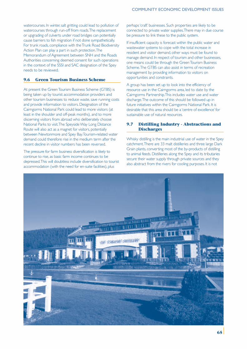
COMMUNITY ECONOMIC DEVELOPMENT ISSUES
watercourses. In winter, salt gritting could lead to pollution ofwatercourses through run-off from roads. The replacementor upgrading of culverts under road bridges can potentiallycause barriers to fish migration if not done sympathetically.For trunk roads, compliance with the Trunk Road BiodiversityAction Plan can play a part in such protection. TheMemorandum of Agreement between SNH and the RoadsAuthorities concerning deemed consent for such operationsin the context of the SSSI and SAC designation of the Speyneeds to be reviewed.
9.6 Green Tourism Business Scheme
At present the Green Tourism Business Scheme (GTBS) isbeing taken up by tourist accommodation providers andother tourism businesses to reduce waste, save running costsand provide information to visitors. Designation of theCairngorms National Park could lead to more visitors (atleast in the shoulder and off-peak months), and to morediscerning visitors from abroad who deliberately chooseNational Parks to visit. The Speyside Way Long DistanceRoute will also act as a magnet for visitors, potentiallybetween Newtonmore and Spey Bay. Tourism-related waterdemand could therefore rise in the medium term after therecent decline in visitor numbers has been reversed.
The pressure for farm business diversification is likely tocontinue to rise, as basic farm income continues to bedepressed. This will doubtless include diversification to touristaccommodation (with the need for en-suite facilities), plus
perhaps ‘craft’ businesses. Such properties are likely to beconnected to private water supplies. There may in due coursebe pressure to link these to the public system.
If insufficient capacity is forecast within the public water andwastewater systems to cope with the total increase inresident and visitor demand, other ways must be found tomanage demand. In respect of tourism and other businesses,one means could be through the Green Tourism BusinessScheme. The GTBS can also assist in terms of recreationmanagement by providing information to visitors onopportunities and constraints.
A group has been set up to look into the efficiency ofresource use in the Cairngorms area, led to date by theCairngorms Partnership. This includes water use and waterdischarge. The outcome of this should be followed up infuture initiatives within the Cairngorms National Park. It isdesirable that this area should be a ‘centre of excellence’ forsustainable use of natural resources.
9.7 Distilling Industry - Abstractions andDischarges
Whisky distilling is the main industrial use of water in the Speycatchment. There are 33 malt distilleries and three large DarkGrain plants, converting most of the by-products of distillingto animal feeds. Distilleries along the Spey and its tributariessecure their water supply through private sources and theyalso abstract from the rivers for cooling purposes. It is not
65
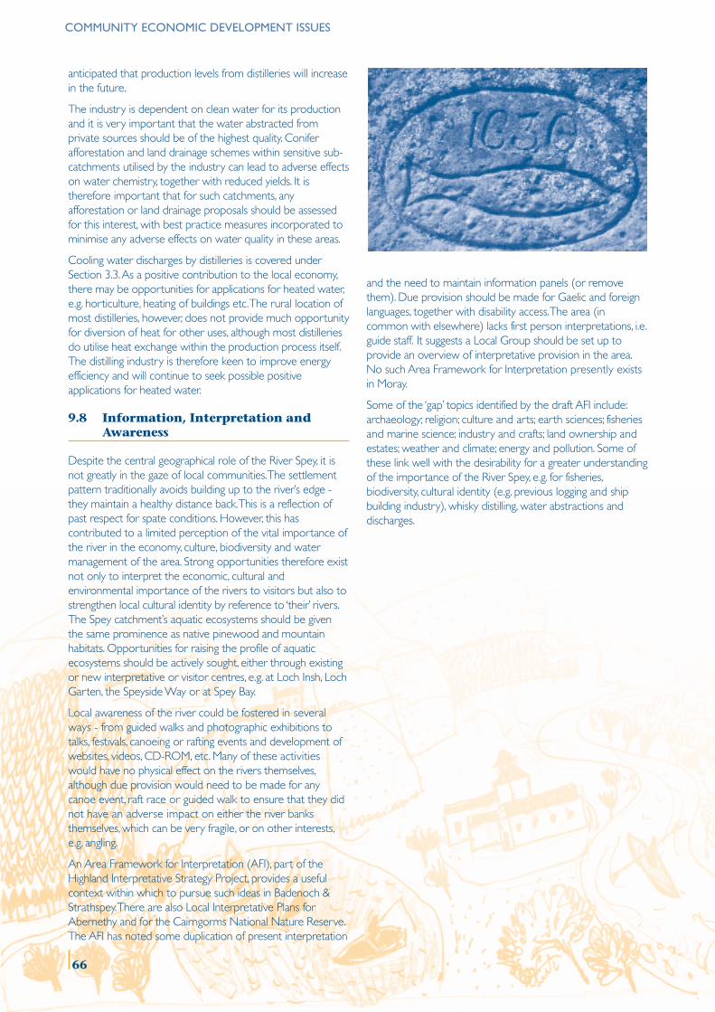
COMMUNITY ECONOMIC DEVELOPMENT ISSUES
anticipated that production levels from distilleries will increasein the future.
The industry is dependent on clean water for its productionand it is very important that the water abstracted fromprivate sources should be of the highest quality. Coniferafforestation and land drainage schemes within sensitive sub-catchments utilised by the industry can lead to adverse effectson water chemistry, together with reduced yields. It istherefore important that for such catchments, anyafforestation or land drainage proposals should be assessedfor this interest, with best practice measures incorporated tominimise any adverse effects on water quality in these areas.
Cooling water discharges by distilleries is covered underSection 3.3. As a positive contribution to the local economy,there may be opportunities for applications for heated water,e.g. horticulture, heating of buildings etc. The rural location ofmost distilleries, however, does not provide much opportunityfor diversion of heat for other uses, although most distilleriesdo utilise heat exchange within the production process itself.The distilling industry is therefore keen to improve energyefficiency and will continue to seek possible positiveapplications for heated water.
9.8 Information, Interpretation andAwareness
Despite the central geographical role of the River Spey, it isnot greatly in the gaze of local communities. The settlementpattern traditionally avoids building up to the river’s edge -they maintain a healthy distance back. This is a reflection ofpast respect for spate conditions. However, this hascontributed to a limited perception of the vital importance ofthe river in the economy, culture, biodiversity and watermanagement of the area. Strong opportunities therefore existnot only to interpret the economic, cultural andenvironmental importance of the rivers to visitors but also tostrengthen local cultural identity by reference to ‘their’ rivers.The Spey catchment’s aquatic ecosystems should be giventhe same prominence as native pinewood and mountainhabitats. Opportunities for raising the profile of aquaticecosystems should be actively sought, either through existingor new interpretative or visitor centres, e.g. at Loch Insh, LochGarten, the Speyside Way or at Spey Bay.
Local awareness of the river could be fostered in severalways - from guided walks and photographic exhibitions totalks, festivals, canoeing or rafting events and development ofwebsites, videos, CD-ROM, etc. Many of these activitieswould have no physical effect on the rivers themselves,although due provision would need to be made for anycanoe event, raft race or guided walk to ensure that they didnot have an adverse impact on either the river banksthemselves, which can be very fragile, or on other interests,e.g. angling.
An Area Framework for Interpretation (AFI), part of theHighland Interpretative Strategy Project, provides a usefulcontext within which to pursue such ideas in Badenoch &Strathspey. There are also Local Interpretative Plans forAbernethy and for the Cairngorms National Nature Reserve.The AFI has noted some duplication of present interpretation
and the need to maintain information panels (or removethem). Due provision should be made for Gaelic and foreignlanguages, together with disability access. The area (incommon with elsewhere) lacks first person interpretations, i.e.guide staff. It suggests a Local Group should be set up toprovide an overview of interpretative provision in the area.No such Area Framework for Interpretation presently existsin Moray.
Some of the ‘gap’ topics identified by the draft AFI include:archaeology; religion; culture and arts; earth sciences; fisheriesand marine science; industry and crafts; land ownership andestates; weather and climate; energy and pollution. Some ofthese link well with the desirability for a greater understandingof the importance of the River Spey, e.g. for fisheries,biodiversity, cultural identity (e.g. previous logging and shipbuilding industry), whisky distilling, water abstractions anddischarges.
66
ISSUE 9.1 FUTURE HOUSING DEVELOPMENT IN THE CATCHMENT
The current Badenoch & Strathspey and Moray Local Plans identify land for about 3000 and 470 new houses, respectively. Thishas implications for both water supply and wastewater treatment.
The projected increases in demand need to be considered carefully in the context of the catchment’s water resource capability.
Major changes are planned for the Loch Einich supply network to make better use of the water from this source to meetdemand until 2016. Beyond that, either another source will be needed, or water will have to be used more efficiently,including leakage management.
MANAGEMENT OBJECTIVE 9.1
Develop greater co-ordination to allow for the linkages between housing development, water and wastewater capacityand environmental issues on quality, including water-saving and pollution minimisation measures.
No. Action Lead Others Timescale*
9.1.1 Scope the Environmental Assessment for the Loch Highland Council Scottish Water ShortEinich water supply upgrade. CNPA SNH
SEPA
9.1.2 Carry out a feasibility study into additional water supply Scottish Water Highland Council Mediumfor the Loch Einich supply catchment area beyond 2016. SEPA
SNH
9.1.3 Assess options for WTW and WWTP to serve Scottish Water SEPA Shortcommunities along river, especially for Aviemore and Highland CouncilCambusmore. Moray Council
SNH
9.1.4 Develop protocol between Planning Authorities, Highland Council Scottish Water ShortScottish Water and SEPA in respect of Development Moray Council SEPAPlans and major applications (including dissemination CNPAof SUDS).
9.1.5 Relate future upgrades of WTW and WWTP against Scottish Water SEPA Mediumlikely SEPA consent levels.
9.1.6 Assess water resource capacity of catchment to Scottish Water SEPA Short/Mediumaccommodate future development. Highland Council
Moray CouncilSNH
CNPA
9.1.7 Promote adoption of water efficiency measures, Scottish Water Mediumincluding in Buildings Regulations, and seek to minimise Highland Councilwater leakage, etc. Moray Council
9.1.8 Develop an educational programme to avoid disposal Scottish Water SEPA Short/Mediumof polluting items in wastewater treatment system.
* Short, medium and long are defined by 1 to 3 years, 4 to 6 years and 6 years plus respectively. This definition for thetimescale applies throughout the document.
COMMUNITY ECONOMIC DEVELOPMENT ISSUES
67
COMMUNITY ECONOMIC DEVELOPMENT ISSUES
ISSUE 9.2 PRIVATE WATER SUPPLY AND TREATMENT
The water and sewerage facilities at Glenmore operate at close to maximum capacity during the summer months, givingrise to concerns about water shortage and wastewater treatment. Other private water supplies and wastewatertreatment facilities can give rise to problems from time to time.
MANAGEMENT OBJECTIVE 9.2
Improve the adequacy of private water supply and wastewater facilities to meet existing demand and comply with existingconsent.
No. Action Lead Others Timescale
9.2.1 Review and implement private water and wastewater Forest Enterprise SEPA Short arrangements including efficiency measures Private Estates Scottish Waterand upgrading.
9.2.2 Investigate any cumulative effects of septic tank SEPA Mediumdischarges from concentrations of houses on freely Highland Councilpercolating soils. Moray Council
ISSUE 9.3 COMMERCIAL AND INDUSTRIAL DEVELOPMENTS
There is the potential for pollution of watercourses during the development and operational stages of a number ofsignificant industrial and commercial developments close to the River Spey or its tributaries, including large-scaledevelopment, golf courses, landfill sites, wind farms and sawmills.
MANAGEMENT OBJECTIVE 9.3
Prevent pollution from new developments at both construction and operational stages.
No. Action Lead Others Timescale
9.3.1 Promote SEPA Guidelines and SUDS for new SEPA Highland Council Shortdevelopments. Moray Council
CNPA
9.3.2 Cross-refer relevant land allocations in Local Plans, and Highland Council Shortrelevant policies in the National Park Plan, to the river’s Moray Councilspecially protected status. CNPA
9.3.3 Scope the issue of fertiliser run-off from golf courses SEPA SNH Mediumthrough the present Golf Course Conservation Initiative. MBSE
9.3.4 Draw up code of practice, if necessary, to address issue SEPA SNH Longof fertiliser run-off from golf courses as part of Golf Course MBSEConservation Initiative.
68
ISSUE 9.4 MINERAL EXTRACTION
Run-off from mineral extraction sites can potentially pollute watercourses.
The Regulations governing the River Spey cSAC affects permitted development rights for commercial mineral operations,and mineral extraction in relation to agricultural and forestry operations.
MANAGEMENT OBJECTIVE 9.4
Increase awareness and understanding of the implications of permitted development arrangements arising from the RiverSpey SAC designation.
No. Action Lead Others Timescale
9.4.1 Prepare explanatory leaflet for circulation to operators Highland Council SNH Shortand other relevant parties. Moray Council
ISSUE 9.5 ROAD AND RAILWAY WORKS
Road and bridge repair and maintenance can potentially pollute watercourses and the replacement or upgrading of culvertscan potentially cause barriers to fish migration.
Run-off from roads in the winter can potentially cause pollution of watercourses.
MANAGEMENT OBJECTIVE 9.5
Prevent pollution or obstructions from significant structural works across the river or from ongoing maintenance andrepair works nearby.
No. Action Lead Others Timescale
9.5.1 Ensure adequate mitigating measures are taken to Highland Council SNH Shortprevent pollution or obstruction of watercourses from Moray Council SEPAstructural works, or repair and maintenance works,and write into relevant applications.
9.5.2 Prepare guidance for Roads Authorities in respect Highland Council SNH Shortof implications of River Spey SSSI and SAC designations, Moray Council SEPAe.g. safeguards against run-off from winter gritting. Scottish Executive
COMMUNITY ECONOMIC DEVELOPMENT ISSUES
69
COMMUNITY ECONOMIC DEVELOPMENT ISSUES
ISSUE 9.6 GREEN TOURISM BUSINESS SCHEME
Tourism-related water demand could rise in the medium term as visitor numbers recover and farm business diversificationcontinues to rise, creating additional pressure on the public water supply and wastewater treatment systems.
The extent and adequacy of private water supplies and septic tanks serving tourist related facilities needs to be investigated.
MANAGEMENT OBJECTIVE 9.6
Mitigate the impact of higher numbers of visitors on both water supply and wastewater systems and also on the naturalheritage and fisheries of the river system.
No. Action Lead Others Timescale
9.6.1 Promote water efficiency and wastewater pollution MBSE Scottish Water Mediumminimisation measures, including through the GTBS.
9.6.2 Recommend to Cairngorms National Park Authority that SCSG Scottish Water Shortwater efficiency should be included in the Park Plan as partof the National Park’s aim of sustainable use of naturalresources of the area.
9.6.3 Include tourism accommodation projections in any Scottish Water SEPA Mediumstudies of future demand for water supply and Highland Councilwastewater treatment. Moray Council
MBSE
9.6.4 Incorporate recreation management information into MBSE SNH Mediumopportunities under GTBS. SFB
Highland CouncilMoray Council
ISSUE 9.7 DISTILLING INDUSTRY – ABSTRACTIONS AND DISCHARGES
Water of the highest quality is required for the whisky distilling industry, the majority of which is abstracted from privatesources. This makes the distilling industry very vulnerable to the effects of land-use changes, such as afforestation and landdrainage schemes, on local watercourses.
Associated with the issues of cooling water discharges potentially adversely affecting the ecology of local burns and thecosts of new infrastructure to meet any tightening of permissible discharge consents, should be consideration of anypositive use of heated water.
MANAGEMENT OBJECTIVE 9.7
Safeguard the quality and quantity of water in the sub-catchments of private distillery supplies and consider any positiveapplication of heated water.
No. Action Lead Others Timescale
9.7.1 Assess afforestation and land drainage proposals with a FC Distilleries Shortview to minimising effects on distillery sub-catchments. SEERAD SEPA
9.7.2 Continue to seek opportunities for possible positive MBSE SEPA Mediumapplications of heated water. Distilleries
70
ISSUE 9.8 INFORMATION, INTERPRETATION AND AWARENESS
Availability of information about the River Spey catchment generally is poor. This has contributed to a lack of awareness andunderstanding of both land-use management issues and the importance of the river in the economy, culture and biodiversity ofthe area.
It is at present difficult to access all the relevant information on best practice management as it is often held in disparateplaces or is under-publicised.
MANAGEMENT OBJECTIVE 9.8
Raise the profile of the economic, cultural and environmental importance of the river and its tributaries among residentsand visitors and establish a better basis for the sharing of information.
No. Action Lead Others Timescale
9.8.1 Look for ways to celebrate the River Spey and raise the SCSG sportscotland Longlevel of local involvement with the river by linking into MBSEcultural and sporting events.
9.8.2 Support the implementation of relevant initiatives under Highland Council Mediumthe AFI for Badenoch & Strathspey.
9.8.3 Seek preparation of an AFI for Moray and link to work Moray Council Speyside Way Shorton Speyside Way. Management
Group
9.8.4 Seek opportunities for raising the profile of the SCSG Visitor centres Mediumimportance of the catchment’s aquatic ecosystems.
9.8.5 Prepare maps and leaflets of local footpath networks Highland Council SNH Shortadjacent to riversides. Moray Council MBSE
FELocal communities
9.8.6 Create a link to existing websites for general awareness SCSG MBSE Mediumraising of the River Spey catchment.
9.8.7 Compile a directory of advisers, contractors, suppliers for SCSG Farmers Shortall land-use management activities together with a FWAG FCcompilation of all ‘Codes of Good Practice’. SLF
9.8.8 Compile relevant information into GIS format and make SCSG Research Institutes Shortit available for land-use management and biodiversityzoning within the catchment.
COMMUNITY ECONOMIC DEVELOPMENT ISSUES
71
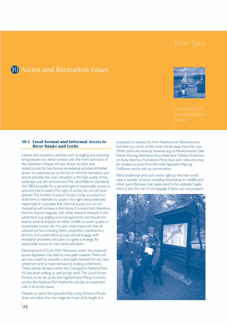
10.1 Local Formal and Informal Access toRiver Banks and Lochs
Leisure and recreation activities such as angling and canoeingbring people into direct contact with the rivers and lochs ofthe catchment. People are also drawn to lochs andwatercourses for less formal recreational activities. Whetherdrawn to watercourses by formal or informal recreation andleisure activities, the main attraction is the high quality of thelandscape and the environment. The Land Reform (Scotland)Act 2003 provides for a general right of responsible access toland and inland waters. The right of access has not yet beendefined. The Scottish Outdoor Access Code, at present indraft form, is intended to assist in this right being exercisedresponsibly. It is possible that informal access (i.e. not onfootpaths) will increase in the future. It is important, therefore,that this should integrate with other relevant interests in thecatchment (e.g. angling, land management) and should notlead to adverse impacts on either wildlife or water quality, orexacerbate erosion etc. It is also vitally important that allrelevant parties, including fishery proprietors, landowners,farmers and conservation groups should engage withrecreation providers and users to agree a strategy forresponsible access to river banks and lochs.
Development of Core Path Networks under the proposedaccess legislation may lead to new path creation. There willalso be a need to consider a local path network for any newsettlement and to meet demand at existing settlements.There will be demand within the Cairngorms National Parkfor low-level walking as well as high level. The Local AccessForums to be set up for the Highland and Moray Councils,and for the National Park Authority, will play an importantrole in all access issues.
Despite its name, the Speyside Way Long Distance Routedoes not follow the river edge for much of its length. It is
proposed to extend this from Aviemore to Newtonmore,but here too, much of the route will be away from the river.Other paths are close by, however, e.g. at Newtonmore, GlenFeshie, Kincraig, Rothiemurchus, Aviemore Orbital, Grantown-on-Spey, Aberlour, Fochabers. More local path networks maybe created as spurs from the main Speyside Way, e.g.Dufftown, and to link up communities.
Paths, bridleways and cycle tracks right by the river couldraise a number of issues including disturbance to wildlife andother users. Because river banks tend to be relatively fragile,there is also the risk of soil slippage if banks are not properly
River Spey
CATCHMENTMANAGEMENTPLAN
10 Access and Recreation Issues
DRAFT DRAFT DRAFT DRAFT DRAFT DRAFT DRAFT River Spey
CATCHMENTMANAGEMENTPLAN
10 Access and Recreation Issues
72
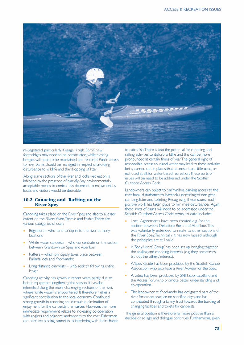
re-vegetated, particularly if usage is high. Some newfootbridges may need to be constructed, while existingbridges will need to be maintained and repaired. Public accessto river banks should be managed in respect of avoidingdisturbance to wildlife and the dropping of litter.
Along some sections of the river and lochs, recreation isinhibited by the presence of blackfly. Any environmentallyacceptable means to control this deterrent to enjoyment bylocals and visitors would be desirable.
10.2 Canoeing and Rafting on theRiver Spey
Canoeing takes place on the River Spey, and also to a lesserextent on the Rivers Avon, Tromie and Feshie. There arevarious categories of user:
• Beginners – who tend to ‘dip in’ to the river at manylocations;
• White water canoeists – who concentrate on the sectionbetween Grantown on Spey and Aberlour;
• Rafters – which principally takes place betweenBallindalloch and Knockando;
• Long distance canoeists – who seek to follow its entirelength.
Canoeing activity has grown in recent years, partly due tobetter equipment lengthening the season. It has alsointensified along the more challenging sections of the river,where ‘white water’ is encountered. It therefore makes asignificant contribution to the local economy. Continuedstrong growth in canoeing could result in diminution ofenjoyment for the canoeists themselves. However, the moreimmediate requirement relates to increasing co-operationwith anglers and adjacent landowners to the river. Fishermencan perceive passing canoeists as interfering with their chance
to catch fish. There is also the potential for canoeing andrafting activities to disturb wildlife and this can be morepronounced at certain times of year. The general right ofresponsible access to inland water may lead to these activitiesbeing carried out in places that at present are little used, ornot used at all, for water-based recreation. These sorts ofissues will be need to be addressed under the ScottishOutdoor Access Code.
Landowners can object to car/minibus parking, access to theriver bank, disturbance to livestock, undressing to don gear,camping, litter and toileting. Recognising these issues, muchpositive work has taken place to minimise disturbances. Again,these sorts of issues will need to be addressed under theScottish Outdoor Access Code. Work to date includes:
• Local Agreements have been created e.g. for thesection between Delliefure Burn and Aberlour. Thiswas voluntarily extended to relate to other sections ofthe River Spey. Technically it has now lapsed, althoughthe principles are still valid.
• A ‘Spey Users’ Group’ has been set up, bringing togetherthe angling and canoeing interests (e.g. they sometimestry out the others’ interest).
• A ‘Spey Guide’ has been produced by the Scottish CanoeAssociation, who also have a River Adviser for the Spey.
• A video has been produced by SNH, sportscotland andthe Access Forum, to promote better understanding andco-operation.
• The landowner at Knockando has designated part of theriver for canoe practice on specified days, and hascontributed through a family Trust towards the building ofchanging facilities and toilets for canoeists.
The general position is therefore far more positive than adecade or so ago and dialogue continues. Furthermore, given
ACCESS & RECREATION ISSUES
73
ACCESS & RECREATION ISSUES
the recent growth in canoeing in recent years, any specificareas or issues concerning additional canoe facilities could beconsidered in Local Plans and also through Local AccessForums.
Detailed information is required on current canoeing andrafting activity on the River Spey and other tributaries, to actas a baseline for monitoring likely future growth. Managing theimpact of growth, whether in the form of agreement, facilitiesor general education, will depend on an understanding of the‘carrying capacity’ of the river. This is a function of:
• Scope for launching and changing without unreasonablyaffecting others;
• Scope for camping or bothying without unreasonablyaffecting others;
• Scope for canoeing/rafting without unreasonably affectingthe enjoyment of anglers and vice-versa (this may behelped to a limited extent, depending on season and flowconditions, by the different times of the day when anglersand paddlers are generally active);
• Scope for canoeists/rafters to reasonably avoid affectingeach other’s enjoyment.
The Environment Agency in England and Wales carried outand published research in November 2000 on the impact ofcanoeing on angling and fish stocks. It was concluded thatthere is no empirical evidence linking canoeing with damageof spawning grounds and stocks. It did, however, re-affirm theneed for an effective communication network betweenanglers and canoeists. This research can also be taken to applyto Scottish salmon rivers.
10.3 Recreation on and Around Lochs
There are two focal areas within the catchment forformalised water-based activities, at Loch Morlich and at LochInsh. Other forms of recreation such as walking, cycling andorienteering, are also popular, particularly around LochMorlich. Some of the other lochs within the catchment havemore intrinsic appeal for quiet, informal recreation and manyof these are also of great importance for nature conservation.While sailing, canoeing, kayaking and wind surfing take placeon Loch Morlich and Loch Insh, both lochs are also ofimportance for breeding birds. Marker buoys are placedstrategically at the start of the canoeing and sailing season tozone Loch Morlich to help minimise disturbance to wildlife. Itis the shallow margin of the loch which is most vulnerable todisturbance and the marker buoys delineate those areaswhich are to be avoided by water recreation users during thebreeding season. In this way, some impacts can be reduced tosome degree. However, disturbance to wildlife is as likely tocome from recreational activities around the loch marginsand there is a need to raise awareness of the wildlifesensitivity and high environmental quality of both LochMorlich and Loch Insh amongst all recreation users.
No motorised water craft are permitted at present to usethese lochs (e.g. jet biking, water skiing), although there isprovision for safety and coaching motorised craft. However, asrestrictions increase on lochs further south (e.g. LochLomond and Trossachs; Lake District), there may be pressureto seek alternative locations further north. The loch at SpeyDam may also be affected by this.
Motorised water sports would conflict with canoeing,sailing and wind surfing. There would also be conflict withother forms of quiet, informal recreation such as walkingand birdwatching. Motorised water sports would also havea greater impact on wildlife. Any potential income to thelocal economy by permitting such activities would have tobe seen in the context of any income lost by these otheractivities being deterred. On balance, the wish is likely tobe to continue to control and regulate any motorisedwater sports on lochs within the catchment. For lochsMorlich and Insh, effective controls are already in place onslipway and vehicular access which deter motorised watersports. There may, however, be a need in due course toformally regulate motorised water sports on these lochsor elsewhere. This could be achieved through the use ofbylaws, through either the local authority or theCairngorms National Park Authority. The use of smalloutboard motors on fishing boats may require exemptionfrom any such controls.
10.4 Economic Importance ofWater-Related Recreation
Up-to-date information on the volume and value to the localeconomy of water-related recreation and tourism is muchneeded. Whilst some work was carried out in the late 1980son the value of salmon fishing and netting in Scotland, a studywhich brings this evaluation up-to-date, but focusing on theRiver Spey catchment, and broadened to include all forms ofwater-based and water-related recreation and tourism, wouldbe of great benefit.
Such a study might initially include –
• Canoeing and rafting
• Sailing and wind surfing
• Angling (all types)
• Speyside Way LDR
• Loch or river related walking facilities, e.g. Rothiemurchus,Glenmore
Beyond this, such information would also be useful ontourism and recreation indirectly linked to the waterresource. Examples include –
• RSPB Loch Garten Centre
• Other bird watching e.g. Insh Marshes, Spey Bay
• Visits to distilleries
Currently there is no objective assessment of the value ofthese activities to the local area and employment, eitherdirectly or indirectly. Ideally such a study would examine notonly the social and economic benefits of recreation in theRiver Spey catchment area, but also the costs to theenvironment of these activities, such as litter, pollution,disturbance to wildlife and the financial expenditure requiredto ameliorate this.
74
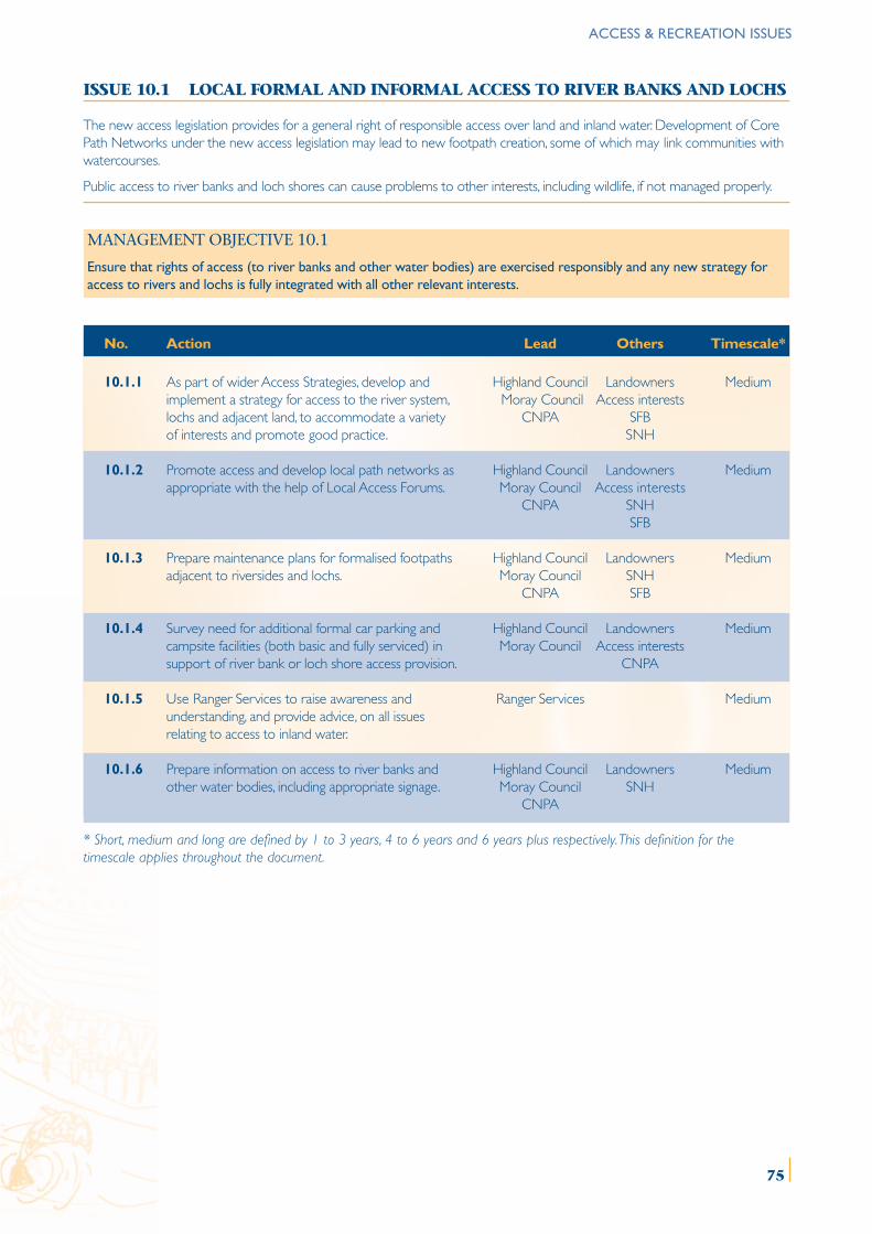
ACCESS & RECREATION ISSUES
ISSUE 10.1 LOCAL FORMAL AND INFORMAL ACCESS TO RIVER BANKS AND LOCHS
The new access legislation provides for a general right of responsible access over land and inland water. Development of CorePath Networks under the new access legislation may lead to new footpath creation, some of which may link communities withwatercourses.
Public access to river banks and loch shores can cause problems to other interests, including wildlife, if not managed properly.
MANAGEMENT OBJECTIVE 10.1
Ensure that rights of access (to river banks and other water bodies) are exercised responsibly and any new strategy foraccess to rivers and lochs is fully integrated with all other relevant interests.
No. Action Lead Others Timescale*
10.1.1 As part of wider Access Strategies, develop and Highland Council Landowners Mediumimplement a strategy for access to the river system, Moray Council Access interestslochs and adjacent land, to accommodate a variety CNPA SFBof interests and promote good practice. SNH
10.1.2 Promote access and develop local path networks as Highland Council Landowners Mediumappropriate with the help of Local Access Forums. Moray Council Access interests
CNPA SNHSFB
10.1.3 Prepare maintenance plans for formalised footpaths Highland Council Landowners Mediumadjacent to riversides and lochs. Moray Council SNH
CNPA SFB
10.1.4 Survey need for additional formal car parking and Highland Council Landowners Mediumcampsite facilities (both basic and fully serviced) in Moray Council Access interestssupport of river bank or loch shore access provision. CNPA
10.1.5 Use Ranger Services to raise awareness and Ranger Services Mediumunderstanding, and provide advice, on all issuesrelating to access to inland water.
10.1.6 Prepare information on access to river banks and Highland Council Landowners Mediumother water bodies, including appropriate signage. Moray Council SNH
CNPA
* Short, medium and long are defined by 1 to 3 years, 4 to 6 years and 6 years plus respectively. This definition for thetimescale applies throughout the document.
75
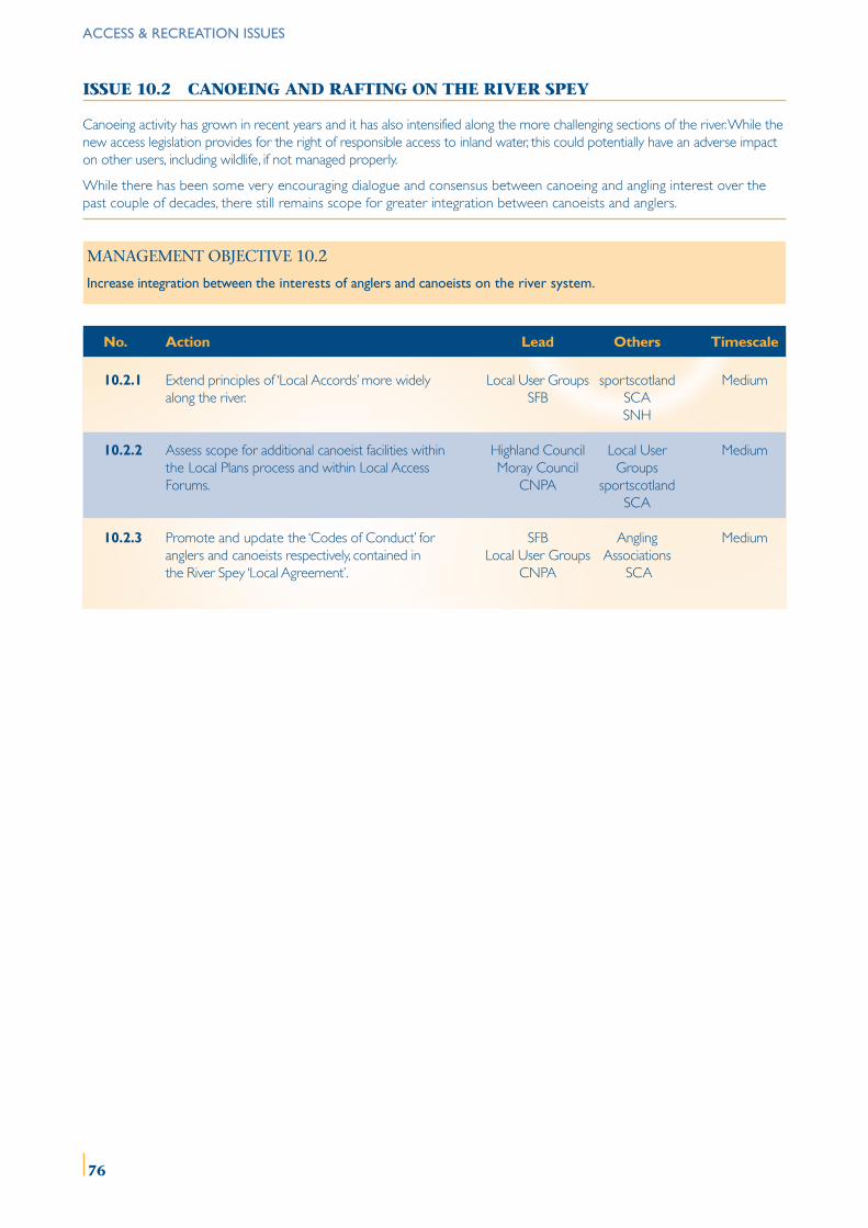
ISSUE 10.2 CANOEING AND RAFTING ON THE RIVER SPEY
Canoeing activity has grown in recent years and it has also intensified along the more challenging sections of the river. While thenew access legislation provides for the right of responsible access to inland water, this could potentially have an adverse impacton other users, including wildlife, if not managed properly.
While there has been some very encouraging dialogue and consensus between canoeing and angling interest over thepast couple of decades, there still remains scope for greater integration between canoeists and anglers.
MANAGEMENT OBJECTIVE 10.2
Increase integration between the interests of anglers and canoeists on the river system.
No. Action Lead Others Timescale
10.2.1 Extend principles of ‘Local Accords’ more widely Local User Groups sportscotland Mediumalong the river. SFB SCA
SNH
10.2.2 Assess scope for additional canoeist facilities within Highland Council Local User Mediumthe Local Plans process and within Local Access Moray Council GroupsForums. CNPA sportscotland
SCA
10.2.3 Promote and update the ‘Codes of Conduct’ for SFB Angling Mediumanglers and canoeists respectively, contained in Local User Groups Associationsthe River Spey ‘Local Agreement’. CNPA SCA
ACCESS & RECREATION ISSUES
76
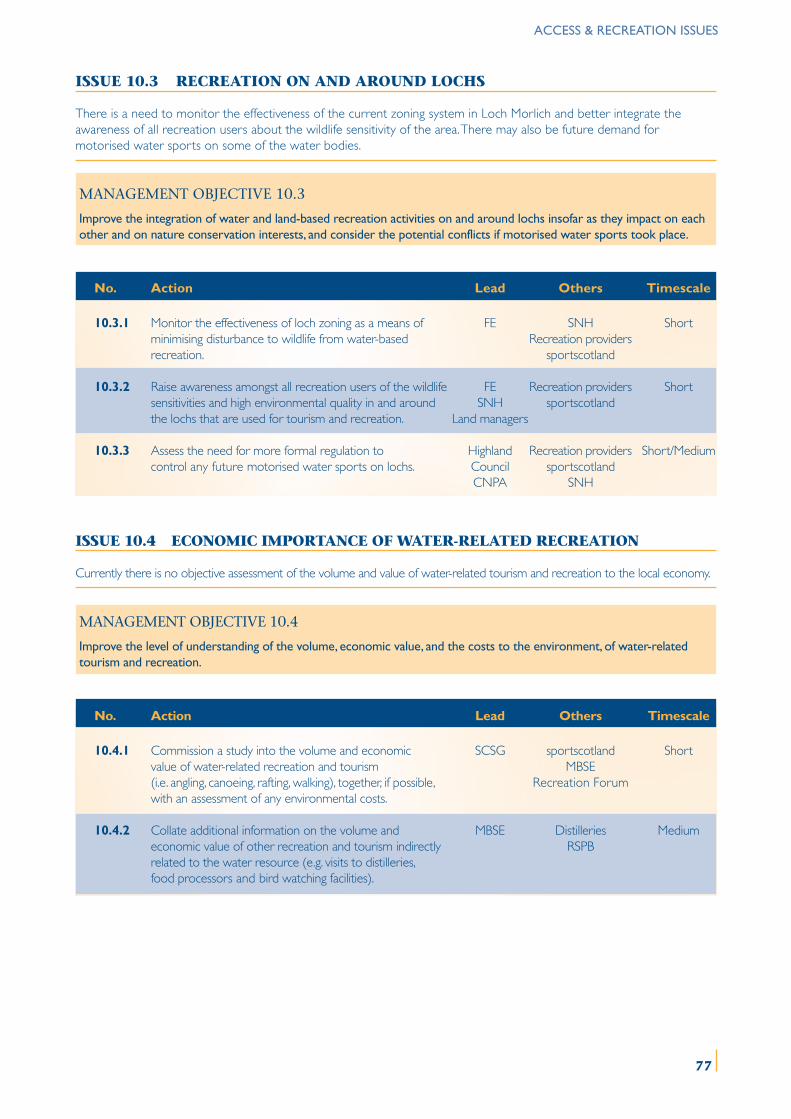
ISSUE 10.3 RECREATION ON AND AROUND LOCHS
There is a need to monitor the effectiveness of the current zoning system in Loch Morlich and better integrate theawareness of all recreation users about the wildlife sensitivity of the area. There may also be future demand formotorised water sports on some of the water bodies.
MANAGEMENT OBJECTIVE 10.3
Improve the integration of water and land-based recreation activities on and around lochs insofar as they impact on eachother and on nature conservation interests, and consider the potential conflicts if motorised water sports took place.
No. Action Lead Others Timescale
10.3.1 Monitor the effectiveness of loch zoning as a means of FE SNH Shortminimising disturbance to wildlife from water-based Recreation providersrecreation. sportscotland
10.3.2 Raise awareness amongst all recreation users of the wildlife FE Recreation providers Shortsensitivities and high environmental quality in and around SNH sportscotlandthe lochs that are used for tourism and recreation. Land managers
10.3.3 Assess the need for more formal regulation to Highland Recreation providers Short/Mediumcontrol any future motorised water sports on lochs. Council sportscotland
CNPA SNH
ISSUE 10.4 ECONOMIC IMPORTANCE OF WATER-RELATED RECREATION
Currently there is no objective assessment of the volume and value of water-related tourism and recreation to the local economy.
MANAGEMENT OBJECTIVE 10.4
Improve the level of understanding of the volume, economic value, and the costs to the environment, of water-relatedtourism and recreation.
No. Action Lead Others Timescale
10.4.1 Commission a study into the volume and economic SCSG sportscotland Shortvalue of water-related recreation and tourism MBSE(i.e. angling, canoeing, rafting, walking), together, if possible, Recreation Forumwith an assessment of any environmental costs.
10.4.2 Collate additional information on the volume and MBSE Distilleries Mediumeconomic value of other recreation and tourism indirectly RSPBrelated to the water resource (e.g. visits to distilleries,food processors and bird watching facilities).
ACCESS & RECREATION ISSUES
77
Appendix A : Funding Partner Addresses
The Highland Council
Planning and Development Service 100 High StreetGlenurquhart Road KingussieInverness IV3 5NX Inverness-shire PH21 1HYTel : 01463 702250 Tel : 01540 661700
Scottish Environment Protection Agency
Erskine Court Pinefield Industrial EstateThe Castle Business Park 28 Perimeter RoadStirling FK9 4TR ElginTel : 01786 457700 Morayshire IV30 6AF
Tel : 01343 547663
Scottish Natural Heritage
Achantoul 32 Reidhaven StreetAviemore ElginInverness-shire PH22 IQD Morayshire IV30 1QHTel : 01479 810477 Tel : 01343 541551
Spey Fishery Board
121 High Street 1 Nether Borlum CottagesForres KnockandoMorayshire IV36 1AB Aberlour AB38 7SDTel : 01309 672216 Tel : 01340 810841
Moray Badenoch & Strathspey Enterprise
The ApexForres Enterprise ParkForresMorayshire IV36 2ABTel : 01309 696000
Moray Council
Department of Environmental ServicesHigh StreetElginMorayshire IV30 1BXTel : 01343 543451
Cairngorms Partnership (now transferred to the Cairngorms National Park Authority)
14 The SquareGrantown-on-SpeyMorayshire PH26 3HGTel : 01479 873535
sportscotland
Caledonia HouseSouth GyleEdinburgh EH12 9DQTel : 0131 317 7200
78
Appendix B : Useful References
Anon. (2001) Report of the Working Group on North Atlantic Salmon. ICES C.M. 2001/ACFM:15
Broadmeadow, S. & Nisbet, T.R. 2002. The effect of riparian woodland management on the freshwaterenvironment. SNIFFER Report SR(02)06F, 162 pp.
Cairngorms Partnership. Cairngorms Forest and Woodland Framework.
Cairngorms Partnership (2002) Cairngorms Local Biodiversity Action Plan. Ed. P Cosgrove
Cairngorms Partnership (2000) Cairngorms Rivers Initiative - Phase 1.
Cairngorms Partnership Management Strategy (1997) Managing the Cairngorms.
Cuthbertson & Partners (1990) Flooding in Badenoch & Strathspey. Final reports to the Highland Regional Council, Vols.,1,2 and 3
David Tyldesley and Associates (2000) Implications of the River Spey SAC for Permitted Development Rights.Scottish Natural Heritage Commissioned Report F99AA507
Forestry Commission (2000) Forests and Water Guidelines. (Third Edition).
Highland Council. Badenoch & Strathspey Local Plan, Adopted 1997.
Highland Council. The Highland Structure Plan. Approved 2001.
Hulme, M., Crossley, J. and Lu, X. (2001). An Exploration of Regional Climate Change Scenarios for Scotland.The Scottish Executive Central Research Unit.
Hulme, M. and Jenkins G. (eds). (1998). UK Climate Impacts Programme. Technical Report No. 1.
Jenkins, D. (1988). Land Use in the River Spey Catchment. Aberdeen Centre for Land Use. Symposium No 1.
Laughton, R. and Smith, G. (1992) The relationship between the date of entry and the estimated spawningposition of adult Atlantic salmon (Salmo salar) in two major East coast rivers. In : Priede, I.G. and Swift, S.M.(eds). Wildlife Telemetry: Remote Monitoring and Tracking of Animals. Ellis Horwood Ltd.,Chichester, England. Pp. 423-433.
MacKenzie, N. Treeline, Riparian and Floodplain Woodlands in the Forest of Spey. Report to the CairngormsPartnership (2001)
Moray Council. Moray Structure Plan. Approved 1999.
Moray Council. Moray Local Plan. Adopted 2000.
NE Scotland Biodiversity Action Plan Partnership (2001) Wet and Riparian Woodland Habitat Action Plan.
North East River Purification Board Publication (1995) River Spey Catchment Review.
Parrott, J., Mackenzie, N. Restoring and Managing Riparian Woodlands. Scottish Native Woods (2000)
Scottish Executive (2001) Rivers, Lochs, Coasts. The Future for Scotland’s Waters.
Scottish Executive (2002) Protection of Scotland’s Water Environment. Consultation on Further Scottish NitrateVulnerable Zones.
Scottish Executive (2003) The Cairngorms National Park Designation, Transitional and ConsequentialProvisions (Scotland) Order 2003.
Scottish Executive. National Planning Policy Guideline 7, Planning and Flooding.
Scottish Executive (draft 2003). Scottish Planning Policy 7, Planning and Flooding.
Scottish Executive (2002) The Future for Scotland’s Waters: Proposals for Legislation.
Scottish Executive (2001) The Rural Stewardship Scheme. Explanatory Book. The Stationery Office Bookshop.
Scottish Natural Heritage (2002) Natural Heritage Futures - North East Glens; Moray Firth; Central Highlands;Cairngorms Massif.
Scottish Natural Heritage (2003). Consultative Draft Scottish Outdoor Access Code.
Scottish Tourist Board (1989) The Economic Importance of Salmon Fishing and Netting in Scotland,Summary report. Scottish Tourist Board and Highlands and Islands Development Board Report.
SOAFD (1993) Cairngorms Strath Environmentally Sensitive Area : Explanatory Leaflet for Farmers. HMSO publication.
Spey District Fishery Board (1998) Management Report and Policy Review.
WWF (Scotland) (2000), Farming and Watercourse Management Handbook. 79
ForewordSalmon fisherman on the River Spey ...................................................................................................................... 1Canoeing on the River Spey ........................................................................................................................................ 4
Chapter 1The meeting of the River Spey and the River Calder at Newtonmore ............................................ 9,10
Chapter 2River bailiffs with broodstock salmon at the SFB’s Knockando hatchery .............................................. 14A Speyside cooperage preparing casks for whisky storage at Craigellachie ........................................ 15
Chapter 3The clear waters of the River Spey tumble over a rocky stream bed .................................................... 18Checking the stills in the Speyside Distillery ........................................................................................................ 19Pine forest timber operations ..................................................................................................................................... 20
Chapter 4Installing the domestic water supply for the upper catchment, Glen Einich ........................................ 25The Speyside Holiday Park and Chalets, Aviemore, in the February 1990 floods ........................... 26The River Spey overtopping its banks at Laggan in the February 1990 floods ............................... 26Spey Dam at Laggan during summer low water levels showing silt layers ........................................... 28
Chapter 5The military bridge over the River Spey at Grantown, a popular spot for salmon anglers ......... 35Salmon fisherman on the River Spey ................................................................................................................... 35River bailiffs with broodstock salmon at the SFB’s Knockando hatchery .............................................. 37
Chapter 6Common terns nesting on River Spey shingle ................................................................................................... 43Red breasted merganser, a sawbill duck ................................................................................................................. 45Water crowfoot (Ranunculus species) .................................................................................................................... 45
Chapter 7Mid Fodderletter Farm on Avonside. Mixed farming and forestry .................................................... 50Harvest time on the valley floor at Rothiemurchus ................................................................................... 50Nesting curlew, a breeding farmland wader species ........................................................................................ 51Mid Fodderletter Farm on Avonside. Mixed farming and forestry .................................................... 52
Chapter 8A forest crop. Felled timber stacked and ready for pulping ......................................................................... 58Larch and pine plantation ............................................................................................................................................. 58Riparian and floodplain woodland at Kinrara, Aviemore ............................................................................... 59
Chapter 9The campsite managed by Forest Enterprise at Glenmore Forest Park ............................................... 63Installing the domestic water supply for the upper catchment, Glen Einich ........................................ 63The Tormore Distillery near Cromdale .................................................................................................................. 65The carved stone above the Tugnet ice house entrance .............................................................................. 66
Chapter 10Sailing on Loch Insh at Kincraig ................................................................................................................................... 72Speyside Way walkers at Craigellachie in Moray ............................................................................................... 72Canoeing on the River Spey ........................................................................................................................................ 73
All photography by David GowansFor ‘Davnik Photography’ Tel: 0771 8130259Email [email protected]
List of photographs:
80
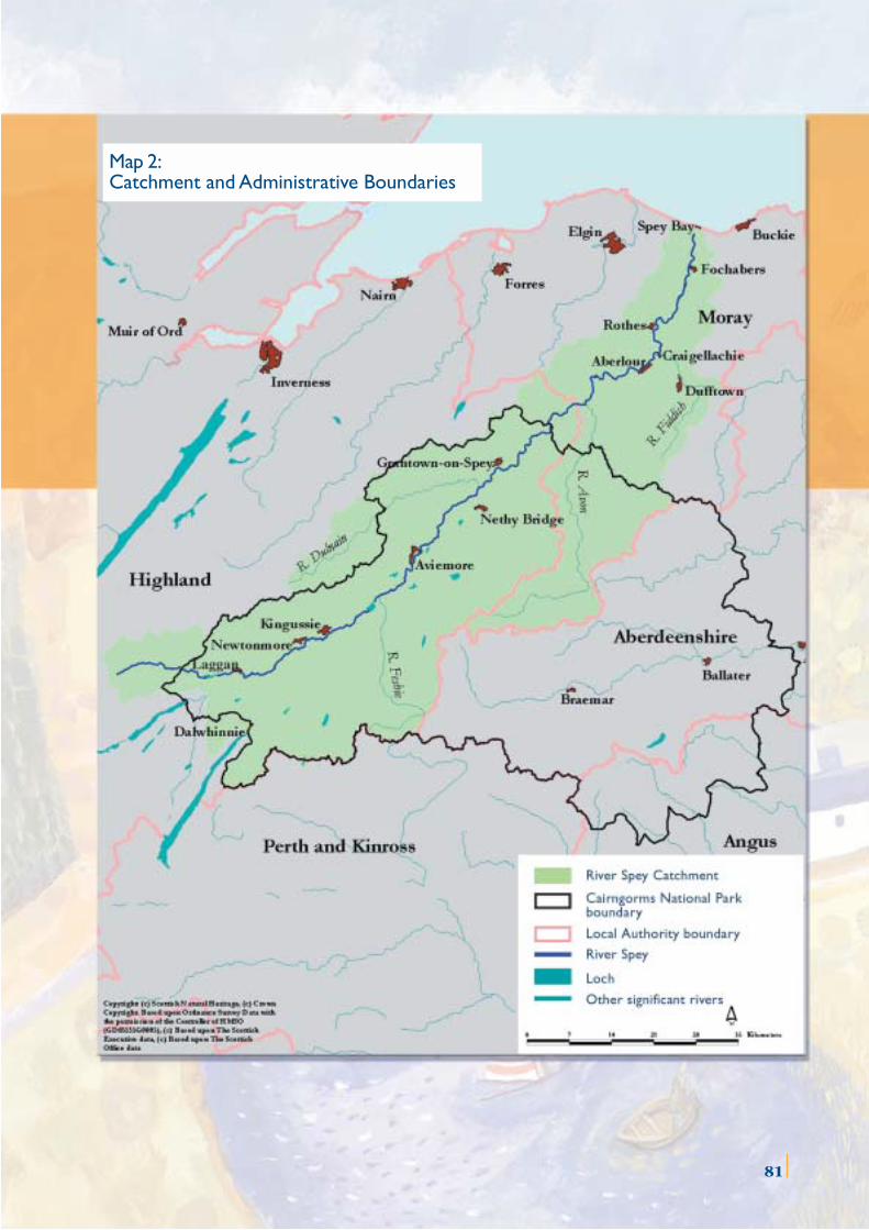
81
Map 2:Catchment and Administrative Boundaries
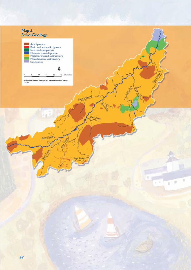
Map 3:Solid Geology
82
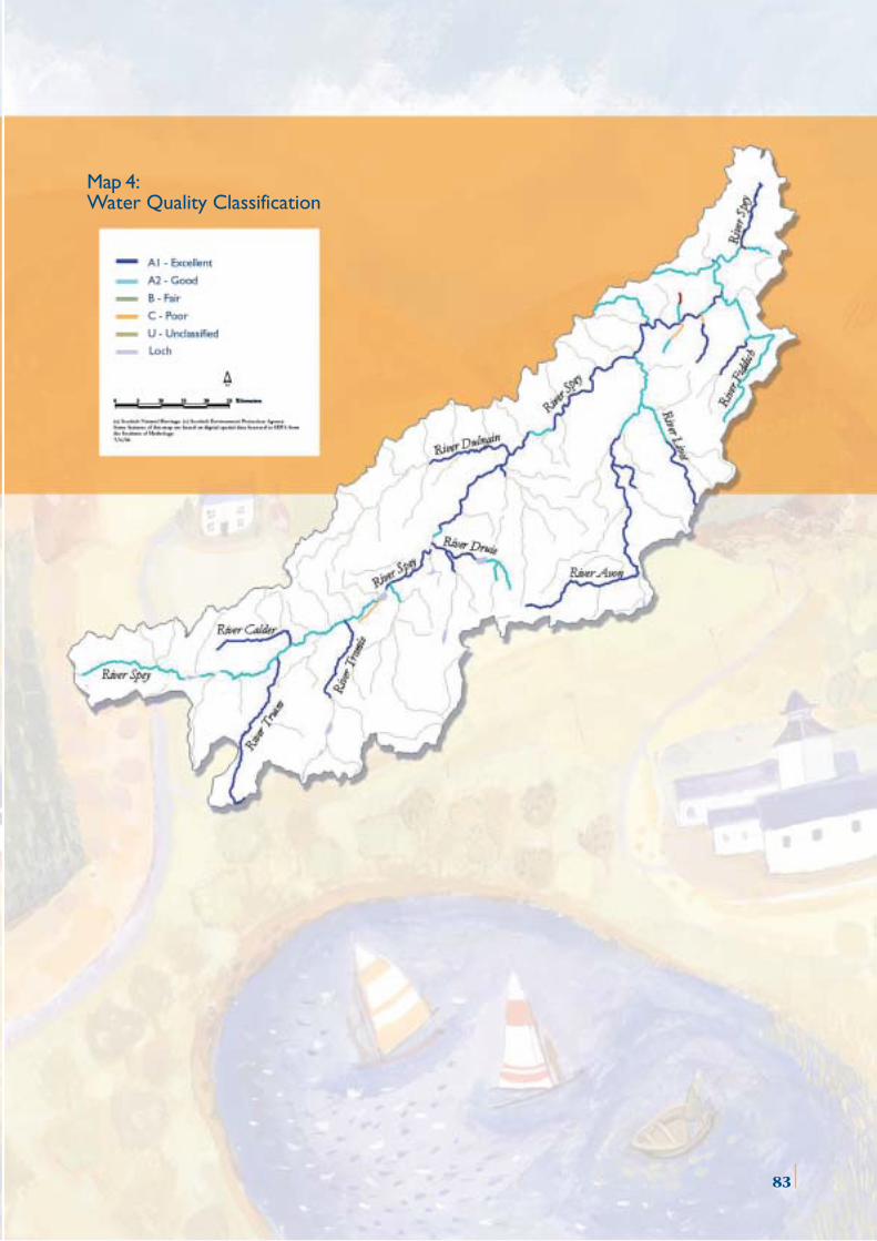
Map 4:Water Quality Classification
83
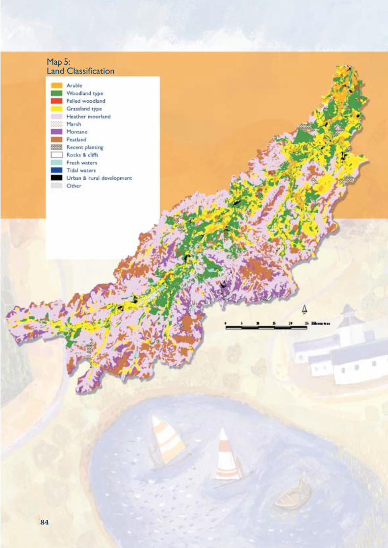
86
Map 5:Land Classification
84
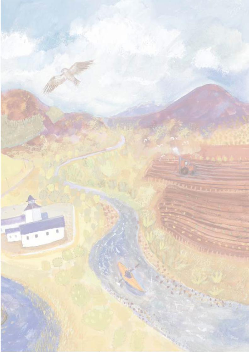

Further copies of this report can be obtained from:
Spey Catchment Steering Groupc/o Achantoul, Aviemore,
Inverness-shire PH22 1QDTel : 01479 810477
Fax : 01479 811363e-mail: [email protected]
This report is also available on the following partnerorganisation websites:
http://www.highland.gov.uk/plintra/riverspey/spey.htm
http://www.moray.org/environment/riverspeyplan.htm
http://www.snh.org.uk/news/pc-intro.htm
http://www.sepa.org.uk/publications/
http://www.hie.co.uk/mbse/riverspey
http://www.sportscotland.org.uk/riverspeycmp.pdf
Pelic
an D
esig
n C
onsu
lt ant
s [
ww
w.p
elic
an-d
esig
n.co
m ]
Pain
t ing/
illus
t rat
ion
by G
illia
n Jo
nes
[ em
ail:
gijo
@ec
osse
.net
]