Embed Size (px)
Citation preview
Trailable and Portable boat
launching locations
North Wales & Borders
River Weaver
Author: Derek Smith
We would like to thank Derek for kindly putting this
information together for waterway visitors
As the information was provided by a third party we cannot guarantee or warrant its completeness or accuracy and accordingly the Trust does not
accept any liability for any inaccuracy or omission in the information provided
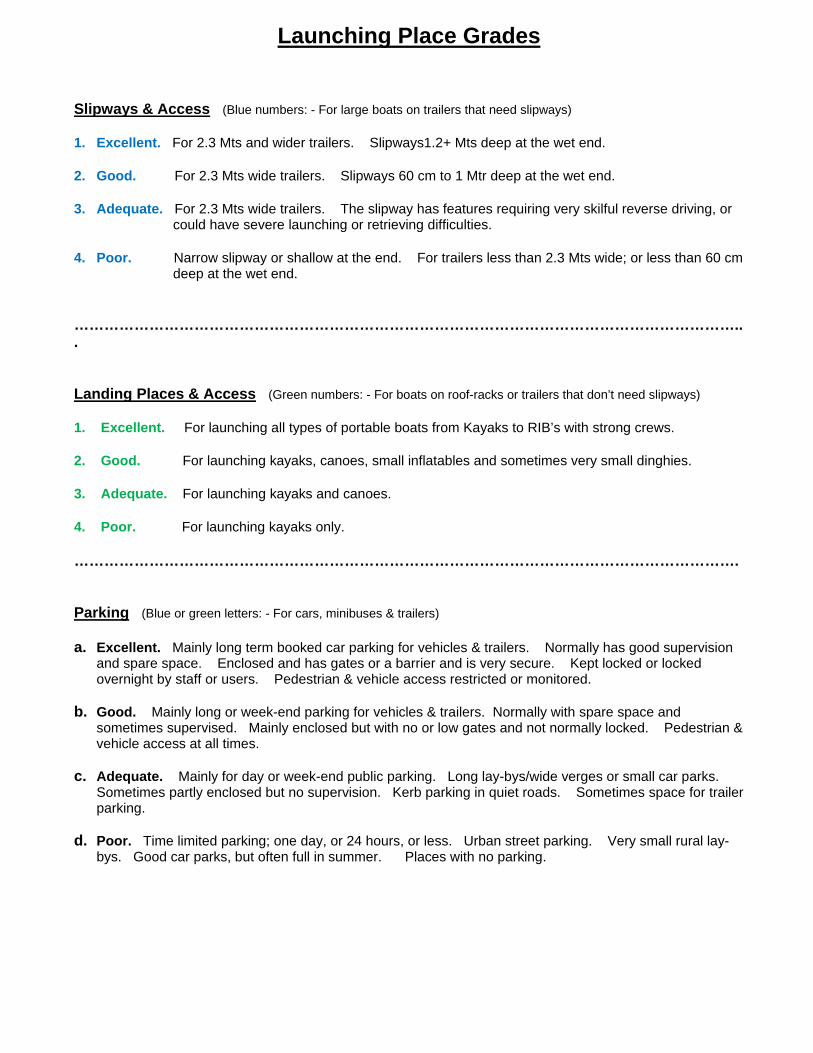
Launching Place Grades Slipways & Access (Blue numbers: - For large boats on trailers that need slipways) 1. Excellent. For 2.3 Mts and wider trailers. Slipways1.2+ Mts deep at the wet end. 2. Good. For 2.3 Mts wide trailers. Slipways 60 cm to 1 Mtr deep at the wet end. 3. Adequate. For 2.3 Mts wide trailers. The slipway has features requiring very skilful reverse driving, or
could have severe launching or retrieving difficulties. 4. Poor. Narrow slipway or shallow at the end. For trailers less than 2.3 Mts wide; or less than 60 cm
deep at the wet end. ……………………………………………………………………………………………………………………... Landing Places & Access (Green numbers: - For boats on roof-racks or trailers that don’t need slipways) 1. Excellent. For launching all types of portable boats from Kayaks to RIB’s with strong crews. 2. Good. For launching kayaks, canoes, small inflatables and sometimes very small dinghies. 3. Adequate. For launching kayaks and canoes. 4. Poor. For launching kayaks only. ……………………………………………………………………………………………………………………. Parking (Blue or green letters: - For cars, minibuses & trailers) a. Excellent. Mainly long term booked car parking for vehicles & trailers. Normally has good supervision
and spare space. Enclosed and has gates or a barrier and is very secure. Kept locked or locked overnight by staff or users. Pedestrian & vehicle access restricted or monitored.
b. Good. Mainly long or week-end parking for vehicles & trailers. Normally with spare space and
sometimes supervised. Mainly enclosed but with no or low gates and not normally locked. Pedestrian & vehicle access at all times.
c. Adequate. Mainly for day or week-end public parking. Long lay-bys/wide verges or small car parks. Sometimes partly enclosed but no supervision. Kerb parking in quiet roads. Sometimes space for trailer parking.
d. Poor. Time limited parking; one day, or 24 hours, or less. Urban street parking. Very small rural lay-
bys. Good car parks, but often full in summer. Places with no parking.
1
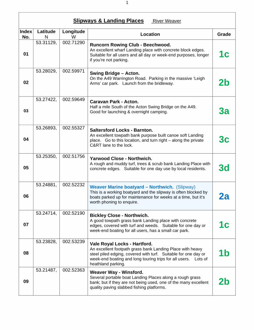
Slipways & Landing Places River Weaver
Index No.
Latitude N
Longitude W
Location Grade
01
53.31129, 002.71290
Runcorn Rowing Club - Beechwood.An excellent wharf Landing place with concrete block edges. Suitable for all users and all day or week-end purposes, longer if you’re not parking.
1c
02
53.28029, 002.59971
Swing Bridge – Acton.On the A49 Warrington Road. Parking in the massive ‘Leigh Arms’ car park. Launch from the bridleway. 2b
03
53.27422, 002.59649
Caravan Park - Acton.Half a mile South of the Acton Swing Bridge on the A49. Good for launching & overnight camping. 3a
04
53.26893, 002.55327
Saltersford Locks - Barnton.An excellent towpath bank purpose built canoe soft Landing place. Go to this location, and turn right – along the private C&RT lane to the lock.
3c
05
53.25350, 002.51756
Yarwood Close - Northwich.A rough and muddy turf, trees & scrub bank Landing Place with concrete edges. Suitable for one day use by local residents. 3d
06
53.24881, 002.52232
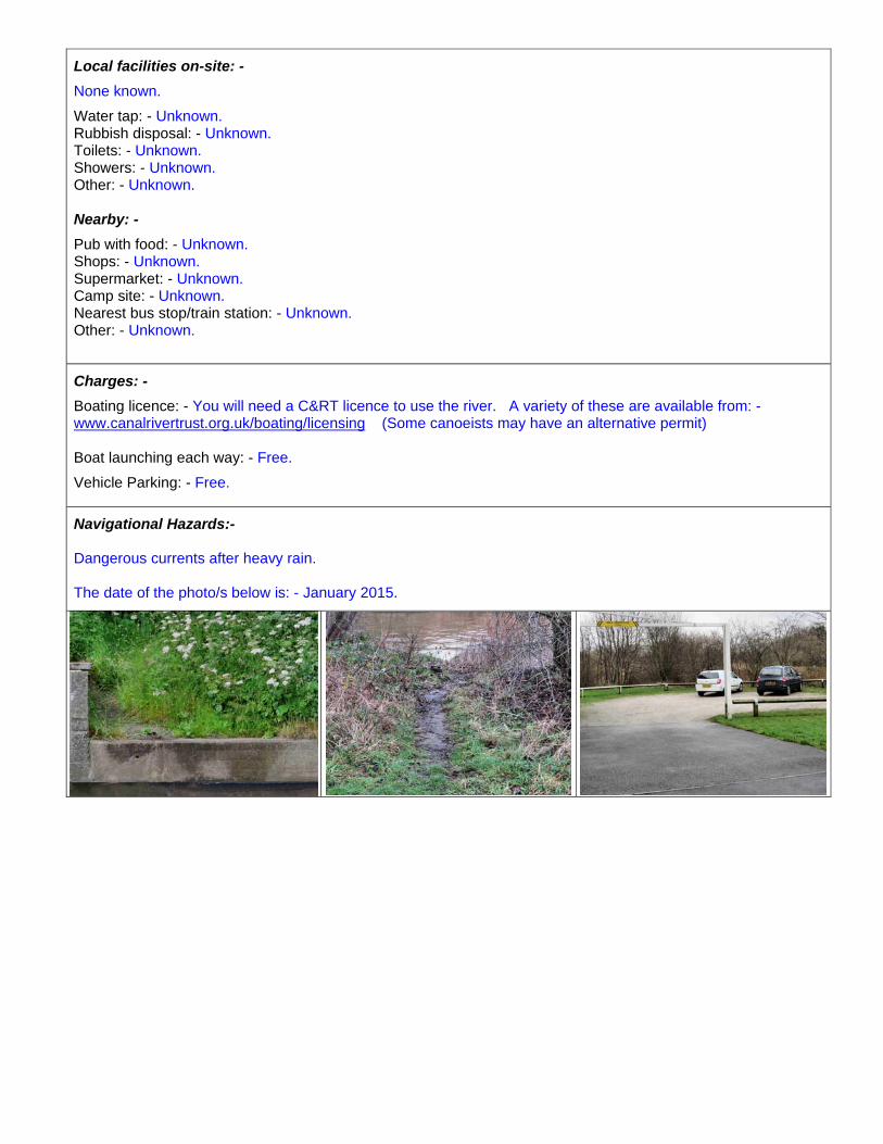
Weaver Marine boatyard – Northwich. (Slipway)This is a working boatyard and the slipway is often blocked by boats parked up for maintenance for weeks at a time, but it’s worth phoning to enquire.
2a
07
53.24714, 002.52190
Bickley Close - Northwich.A good towpath grass bank Landing place with concrete edges, covered with turf and weeds. Suitable for one day or week-end boating for all users, has a small car park.
1c
08
53.23828, 002.53239
Vale Royal Locks - Hartford.An excellent footpath grass bank Landing Place with heavy steel piled edging, covered with turf. Suitable for one day or week-end boating and long touring trips for all users. Lots of heathland parking.
1b
09
53.21487, 002.52363
Weaver Way - Winsford.Several portable boat Landing Places along a rough grass bank; but if they are not being used, one of the many excellent quality paving slabbed fishing platforms.
2b
2
10
53.19323, 002.51665
Red Lion Hotel - Winsford.An excellent public towpath fishing point and Landing Place. Parking and access to the towpath is private and belongs to the hotel.
2b
11
53.19041, 002.51697
Bottom Flash - Winsford. (Slipway)Public, owned by Cheshire West & Chester Council, and has a 14 hours parking limit unless you park privately next door. Shallow and only suitable for very small boats.
4a
Index No.
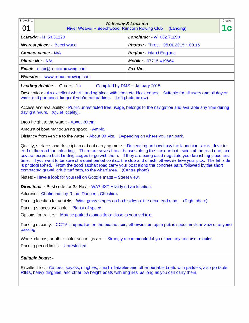
01 Waterway & Location
River Weaver ~ Beechwood; Runcorn Rowing Club (Landing)
Grade
1cLatitude: - N 53.31129 Longitude: - W 002.71290
Nearest place: - Beechwood Photos: - Three. 05.01.2015 ~ 09.15
Contact name: - N/A Region: - Inland England
Phone No: - N/A Mobile: - 07715 419864
Email: - [email protected] Fax No: -
Website: - www.runcornrowing.com
Landing details: - Grade: - 1c Compiled by DMS ~ January 2015
Description: - An excellent wharf Landing place with concrete block edges. Suitable for all users and all day or week-end purposes, longer if you’re not parking. (Left photo below)
Access and availability: - Public unrestricted free usage, belongs to the navigation and available any time during daylight hours. (Quiet locality).
Drop height to the water: - About 30 cm.
Amount of boat manoeuvring space: - Ample.
Distance from vehicle to the water: - About 30 Mts. Depending on where you can park.
Quality, surface, and description of boat carrying route: - Depending on how busy the launching site is, drive to end of the road for unloading. There are several boat houses along the bank on both sides of the road end, and several purpose built landing stages to go with them. If they are being used negotiate your launching place and time. If you want to be sure of a quiet period contact the club and check, otherwise take your pick. The left side is photographed. From the good asphalt road carry your boat along the concrete path, followed by the short compacted gravel, grit & turf path, to the wharf area. (Centre photo)
Notes: - Have a look for yourself on Google maps – Street view.
Directions: - Post code for SatNav: - WA7 4XT ~ fairly urban location.
Address: - Cholmondeley Road, Runcorn, Cheshire.
Parking location for vehicle: - Wide grass verges on both sides of the dead end road. (Right photo)
Parking spaces available: - Plenty of space.
Options for trailers: - May be parked alongside or close to your vehicle.
Parking security: - CCTV in operation on the boathouses, otherwise an open public space in clear view of anyone passing.
Wheel clamps, or other trailer securings are: - Strongly recommended if you have any and use a trailer.
Parking period limits: - Unrestricted.
Suitable boats: -
Excellent for: - Canoes, kayaks, dinghies, small inflatables and other portable boats with paddles; also portable RIB's, heavy dinghies, and other low height boats with engines, as long as you can carry them.
Local facilities on-site: - If any of the boat clubs are open just ask.
Water tap: - Unknown. Rubbish disposal: - Unknown. Toilets: - Unknown. Showers: - Unknown.
Nearby: - Unknown. Pub with food: - Unknown. Shops: - Unknown. Supermarket: - Unknown. Camp site: - Unknown. Nearest bus stop/train station: - Unknown. Other: - Unknown.
Charges: -
Boating licence: - You will need a C&RT licence to use the river. A variety of these are available from: - www.canalrivertrust.org.uk/boating/licensing (Some canoeists may have an alternative permit)
Boat launching each way: - Free.
Vehicle & trailer parking: - Free.
Navigational Hazards:-
Dangerous currents after heavy rain.
The date of the photo/s below is: - January 2015.
Index No.
02 Waterway & Location
River Weaver ~ Acton Swing Bridge; Acton Bridge, The Leigh Arms (Landing)
Grade
2bLatitude: - N 53.28029 Longitude: - W 002.59971
Nearest place: - Acton Bridge village Photos: - Six. 05.01.2015 ~ 11.15 am
Contact name: - Unknown. Region: - Inland England.
Phone No: - 01606 853327 Mobile: -
Email: - Use website form. Fax No: -
Website: - www.leigharms.co.uk
Landing details: - Grade: - 2b Compiled by DMS ~ January 2015
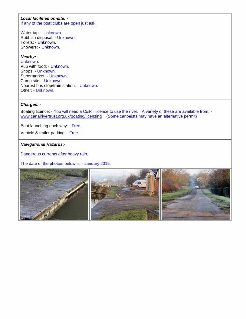
Description: - A good sloping towpath grass bank Landing place with stone slab edges. Most suitable for one day or week-end use. (Left photo below)
Access and availability: - Public unrestricted free usage of the landing; belongs to the navigation and available any time during daylight hours. (Quiet locality, but very popular with walkers in the summer). Drop height to the water: - About 20 cm.
Amount of boat manoeuvring space: - Sufficient.
Distance from vehicle to the water: - About 40 Mts, depending on where you park.
Quality, surface, and description of boat carrying route: - Park on the pub car park in the corner nearest the bridge – the car park is massive, but if you’re a large party best phone them first. Carry your boat out onto the pavement, round the corner, and through the public footpath small gate on your left. (Center photo). Carry down the excellent wide asphalt bridleway and down the good grass bank to the landing. There is a very rough and challenging short cut just behind the small tree on the left.
Notes: - Have a look for yourself on Google maps – Street view.
Directions: - Post code for SatNav: - CW8 4QT ~ fairly rural location.
Address: - Warrington Road A49, The Leigh Arms, Little Leigh, Nr. Northwich, Cheshire.
Parking location for vehicle: - Private pub car park. Frequently used by walkers and canoeists. (Right photo)
Parking spaces available: - Plenty of space.
Options for trailers: - May be parked attached to your car, alongside or close to your car, depending on space available. Parking security: - CCTV in operation but not sure of the coverage, otherwise it’s enclosed private and staffed daytime, but with no gates or barrier.
Wheel clamps, or other trailer securings are: - Strongly recommended if you have any and use a trailer.
Parking period limits: - Negotiable, if you want to park overnight check with the pub.
Suitable boats: -
Good for: - Canoes, kayaks, small inflatables and very small dinghies. (Unsuitable for larger boats)
Local facilities on-site: -
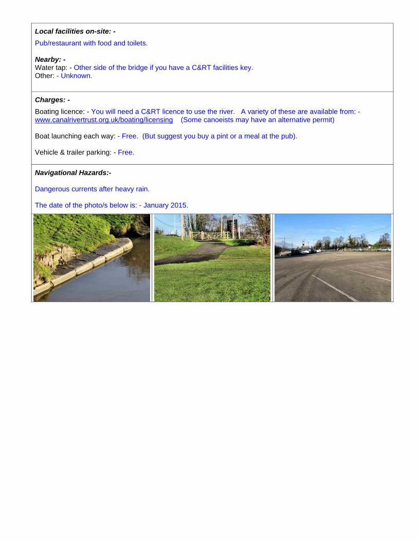
Pub/restaurant with food and toilets.
Nearby: - Water tap: - Other side of the bridge if you have a C&RT facilities key. Other: - Unknown.
Charges: -
Boating licence: - You will need a C&RT licence to use the river. A variety of these are available from: - www.canalrivertrust.org.uk/boating/licensing (Some canoeists may have an alternative permit)
Boat launching each way: - Free. (But suggest you buy a pint or a meal at the pub).
Vehicle & trailer parking: - Free.
Navigational Hazards:-
Dangerous currents after heavy rain.
The date of the photo/s below is: - January 2015.
Index No.
03 Waterway & Location
River Weaver ~ Acton Bridge; Caravan Park (Landing)
Grade
3aLatitude: - N 53.27422 Longitude: - W 002.59649
Nearest place: - Acton Bridge village Photos: - Three. 05.01.2015 ~ 12.30 pm
Contact name: - Mr & Mrs J Done Region: - Inland England
Phone No: - 01606 852319 Mobile: -
Email: - [email protected] Fax No: -
Website: - www.woodbinecottage-caravanpark.co.uk
Landing details: - Grade: - 3a Compiled by DMS ~ January 2015
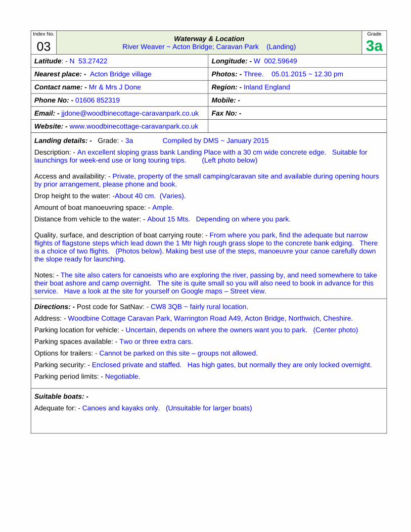
Description: - An excellent sloping grass bank Landing Place with a 30 cm wide concrete edge. Suitable for launchings for week-end use or long touring trips. (Left photo below)
Access and availability: - Private, property of the small camping/caravan site and available during opening hours by prior arrangement, please phone and book. Drop height to the water: -About 40 cm. (Varies).
Amount of boat manoeuvring space: - Ample.
Distance from vehicle to the water: - About 15 Mts. Depending on where you park.
Quality, surface, and description of boat carrying route: - From where you park, find the adequate but narrow flights of flagstone steps which lead down the 1 Mtr high rough grass slope to the concrete bank edging. There is a choice of two flights. (Photos below). Making best use of the steps, manoeuvre your canoe carefully down the slope ready for launching.
Notes: - The site also caters for canoeists who are exploring the river, passing by, and need somewhere to take their boat ashore and camp overnight. The site is quite small so you will also need to book in advance for this service. Have a look at the site for yourself on Google maps – Street view.
Directions: - Post code for SatNav: - CW8 3QB ~ fairly rural location.
Address: - Woodbine Cottage Caravan Park, Warrington Road A49, Acton Bridge, Northwich, Cheshire.
Parking location for vehicle: - Uncertain, depends on where the owners want you to park. (Center photo)
Parking spaces available: - Two or three extra cars.
Options for trailers: - Cannot be parked on this site – groups not allowed.
Parking security: - Enclosed private and staffed. Has high gates, but normally they are only locked overnight.
Parking period limits: - Negotiable.
Suitable boats: -
Adequate for: - Canoes and kayaks only. (Unsuitable for larger boats)
Local facilities on-site: -
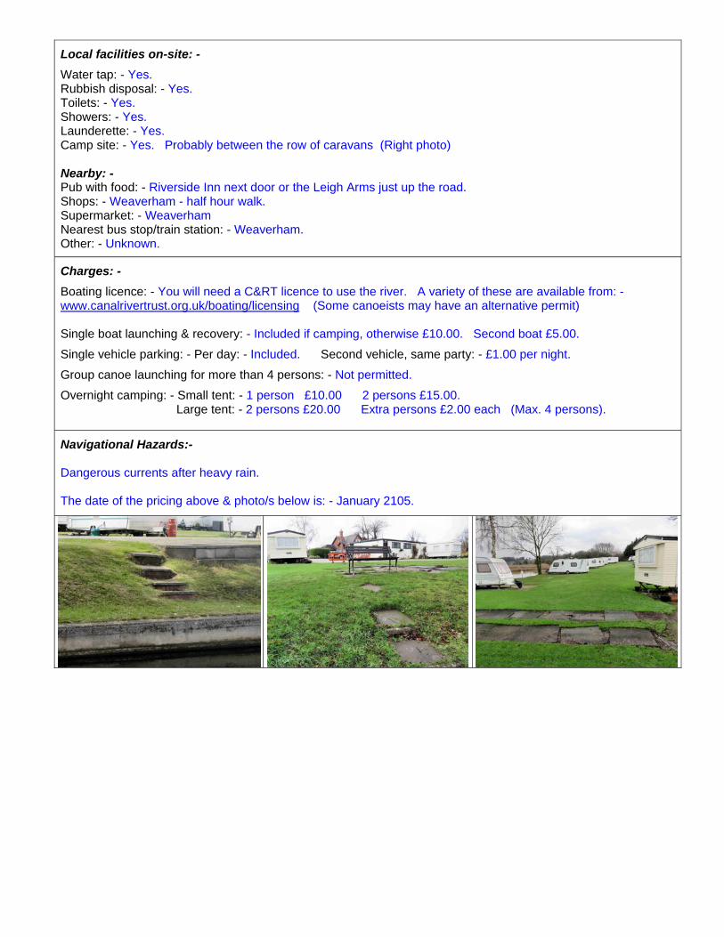
Water tap: - Yes. Rubbish disposal: - Yes. Toilets: - Yes. Showers: - Yes. Launderette: - Yes. Camp site: - Yes. Probably between the row of caravans (Right photo)
Nearby: - Pub with food: - Riverside Inn next door or the Leigh Arms just up the road. Shops: - Weaverham - half hour walk. Supermarket: - Weaverham Nearest bus stop/train station: - Weaverham. Other: - Unknown.
Charges: -
Boating licence: - You will need a C&RT licence to use the river. A variety of these are available from: - www.canalrivertrust.org.uk/boating/licensing (Some canoeists may have an alternative permit)
Single boat launching & recovery: - Included if camping, otherwise £10.00. Second boat £5.00.
Single vehicle parking: - Per day: - Included. Second vehicle, same party: - £1.00 per night.
Group canoe launching for more than 4 persons: - Not permitted.
Overnight camping: - Small tent: - 1 person £10.00 2 persons £15.00. Large tent: - 2 persons £20.00 Extra persons £2.00 each (Max. 4 persons).
Navigational Hazards:-
Dangerous currents after heavy rain.
The date of the pricing above & photo/s below is: - January 2105.
Index No.
04 Waterway & Location
River Weaver ~ Barnton; Saltersford Locks (Landing)
Grade
3cLatitude: - N 53.26893 Longitude: - W 002.55327
Nearest place: - Barnton. Photos: - Two 08.01.2015 ~ 09.45 am
Contact name: - N/A Region: - Inland England
Phone No: - N/A Mobile: - N/A
Email: - None. Fax No: -
Website: - None.
Landing details: - Grade: - 3c Compiled by DMS ~ January 2015
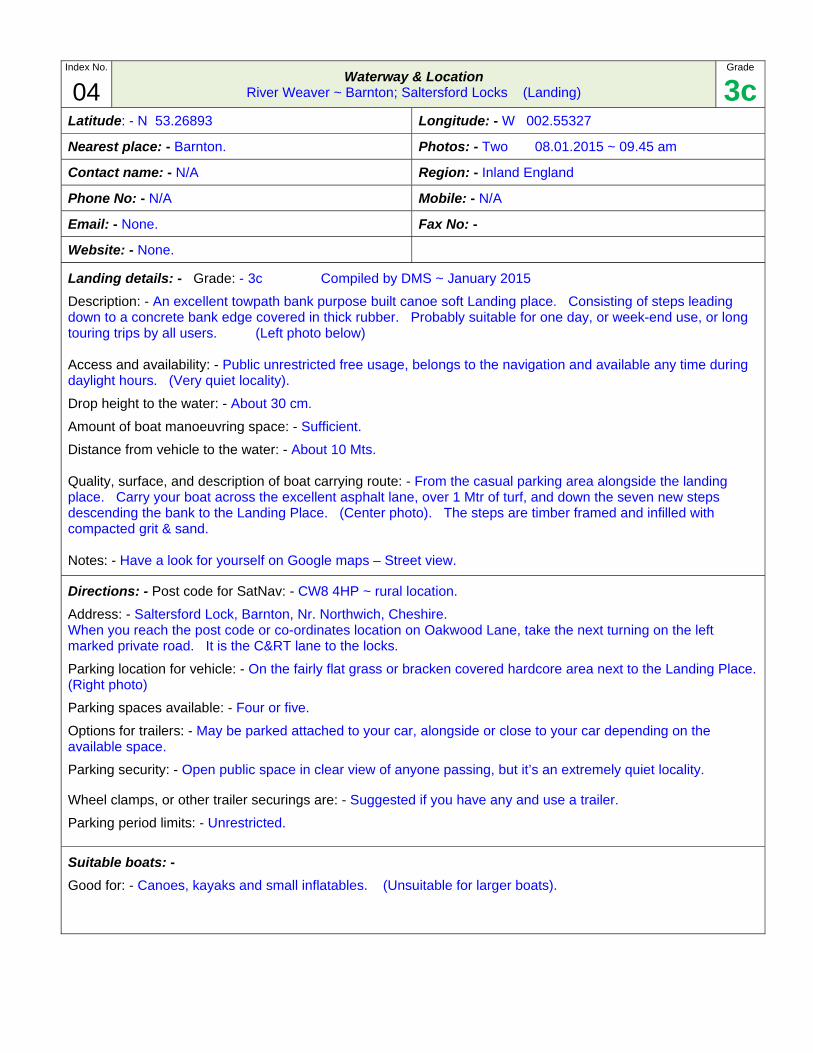
Description: - An excellent towpath bank purpose built canoe soft Landing place. Consisting of steps leading down to a concrete bank edge covered in thick rubber. Probably suitable for one day, or week-end use, or long touring trips by all users. (Left photo below)
Access and availability: - Public unrestricted free usage, belongs to the navigation and available any time during daylight hours. (Very quiet locality). Drop height to the water: - About 30 cm.
Amount of boat manoeuvring space: - Sufficient.
Distance from vehicle to the water: - About 10 Mts.
Quality, surface, and description of boat carrying route: - From the casual parking area alongside the landing place. Carry your boat across the excellent asphalt lane, over 1 Mtr of turf, and down the seven new steps descending the bank to the Landing Place. (Center photo). The steps are timber framed and infilled with compacted grit & sand.
Notes: - Have a look for yourself on Google maps – Street view.
Directions: - Post code for SatNav: - CW8 4HP ~ rural location.
Address: - Saltersford Lock, Barnton, Nr. Northwich, Cheshire. When you reach the post code or co-ordinates location on Oakwood Lane, take the next turning on the left marked private road. It is the C&RT lane to the locks.
Parking location for vehicle: - On the fairly flat grass or bracken covered hardcore area next to the Landing Place.(Right photo)
Parking spaces available: - Four or five.
Options for trailers: - May be parked attached to your car, alongside or close to your car depending on the available space.
Parking security: - Open public space in clear view of anyone passing, but it’s an extremely quiet locality.
Wheel clamps, or other trailer securings are: - Suggested if you have any and use a trailer.
Parking period limits: - Unrestricted.
Suitable boats: -
Good for: - Canoes, kayaks and small inflatables. (Unsuitable for larger boats).
Local facilities on-site: -
Unknown. None.
Nearby: -
Pub with food: - Unknown. Shops: - Unknown. Supermarket: - Unknown. Camp site: - Unknown. Nearest bus stop/train station: - Unknown. Other: - Unknown.
Charges: -
Boating licence: - You will need a C&RT licence to use the river. A variety of these are available from: - www.canalrivertrust.org.uk/boating/licensing (Some canoeists may have an alternative permit)
Boat launching each way: - Free.
Vehicle & trailer parking: - Free.
Navigational Hazards:-
Dangerous currents after heavy rain.
The date of the photo/s below is: - January 2015.
Index No.
05 Waterway & Location
River Weaver ~ Northwich; Yarwood Close (Landing)
Grade
3dLatitude: - N 53.25350 Longitude: - W 002.51756
Nearest place: - Northwich Photos: - Two. 05.01.2015 ~ 14.00
Contact name: - N/A Region: - Inland England
Phone No: - N/A Mobile: - N/A
Email: - None. Fax No: -
Website: - None.
Landing details: - Grade: - 3d Compiled by DMS ~ January 2015
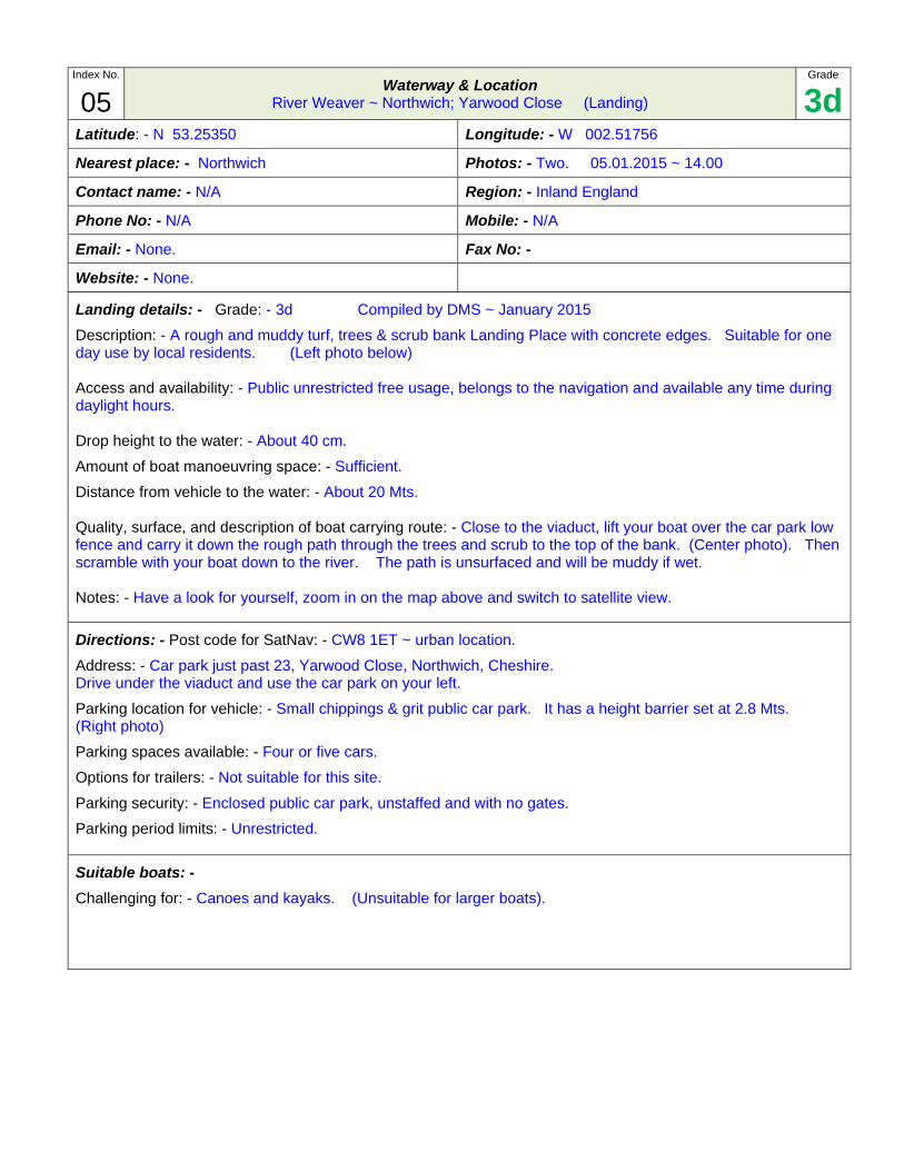
Description: - A rough and muddy turf, trees & scrub bank Landing Place with concrete edges. Suitable for one day use by local residents. (Left photo below)
Access and availability: - Public unrestricted free usage, belongs to the navigation and available any time during daylight hours.
Drop height to the water: - About 40 cm.
Amount of boat manoeuvring space: - Sufficient.
Distance from vehicle to the water: - About 20 Mts.
Quality, surface, and description of boat carrying route: - Close to the viaduct, lift your boat over the car park low fence and carry it down the rough path through the trees and scrub to the top of the bank. (Center photo). Then scramble with your boat down to the river. The path is unsurfaced and will be muddy if wet.
Notes: - Have a look for yourself, zoom in on the map above and switch to satellite view.
Directions: - Post code for SatNav: - CW8 1ET ~ urban location.
Address: - Car park just past 23, Yarwood Close, Northwich, Cheshire. Drive under the viaduct and use the car park on your left.
Parking location for vehicle: - Small chippings & grit public car park. It has a height barrier set at 2.8 Mts. (Right photo)
Parking spaces available: - Four or five cars.
Options for trailers: - Not suitable for this site.
Parking security: - Enclosed public car park, unstaffed and with no gates.
Parking period limits: - Unrestricted.
Suitable boats: -
Challenging for: - Canoes and kayaks. (Unsuitable for larger boats).
Local facilities on-site: -
None known.
Water tap: - Unknown. Rubbish disposal: - Unknown. Toilets: - Unknown. Showers: - Unknown. Other: - Unknown.
Nearby: -
Pub with food: - Unknown. Shops: - Unknown. Supermarket: - Unknown. Camp site: - Unknown. Nearest bus stop/train station: - Unknown. Other: - Unknown.
Charges: -
Boating licence: - You will need a C&RT licence to use the river. A variety of these are available from: - www.canalrivertrust.org.uk/boating/licensing (Some canoeists may have an alternative permit)
Boat launching each way: - Free.
Vehicle Parking: - Free.
Navigational Hazards:-
Dangerous currents after heavy rain.
The date of the photo/s below is: - January 2015.
Index No.
06 Waterway & Location
River Weaver ~ Northwich; Weaver Marine boatyard (Slipway)
Grade
2aLatitude: - N 53.24881 Longitude: - W 002.52232
Nearest place: - Winsford Photos: - Two. 08.01.2015 ~ 11.00 am
Contact name: - Region: - Inland England
Phone No: - 01606 77870 Mobile: -
Email: - [email protected] Fax No: -
Website: - www.jalsea.co.uk
Ramp Description: - Grade: - 2a Compiled by DMS ~ January 2015
Slipway Type: - Good concrete slipway entirely dug deep into the bank, and finishing level with the bank. Most suitable for week-end users and holiday touring trips. (Photo below)
Access: - Private, property of Cathedral Marina, Ely; the parent organisation. Only available by prior arrangement, please phone and book. The slipway will only be available occasionally. This is a working boatyard and the slipway is often blocked by boats parked up for maintenance for weeks at a time, but it’s worth phoning to enquire. (Quiet locality.)
Useable width: - 7 Mts.
Length of the slope above the water: - 6 Mts.
Drop to the water: - 1 Mtr.
Therefore gradient above the water: - 1:6
Length of the slope below the water: - 6 Mts
Depth at the end of the underwater slope: - 0.85 Mts (Will be deeper when the river is high).
Therefore underwater gradient: - 1:7
Length of any level bed after the slope: - Very gradual drop to 1 Mtr over the next 4 Mts.
What’s at the end of the concrete: - Level with the bank - a sudden drop to 1.5+ Mts.
Quality & surface of vehicle manoeuvring area: - Compacted chippings & grit of good quality.
Amount of trailer manoeuvring space: - Ample.
Quality & type of crew boarding facility: - Adequate quality. Remove your trailer, pull the boat back into the slip and use the wharf in the slip cutting on the right hand side.
Height above the water: - About 1 Mtr.
Distance for carrying portable boats: - You can unload your boat and lower it straight onto the water on the slipway.
Notes: - From the information given, remember to consider possible retrieval problems. Have a look for yourself, zoom in on the map above and switch to satellite view.
Directions: - Post code for SatNav: - CW8 1LB ~ fairly urban location.
Address: - Weaver Marine, Saxons Lane, Northwich, Cheshire.
Parking location - vehicle: - Uncertain. It’s a very big site. (Right Photo shows the yard by the slipway)
Parking spaces available for: - Probably four or five units.
Parking for trailer: - May be parked attached to your car or alongside your car or elsewhere on this site.
Parking security: - Enclosed private and staffed, high gated, but normally only locked overnight.
Wheel clamps, or other trailer securings are: - Probably desirable if you have any.
Parking period limits: - Negotiable.
Suitable boats: -
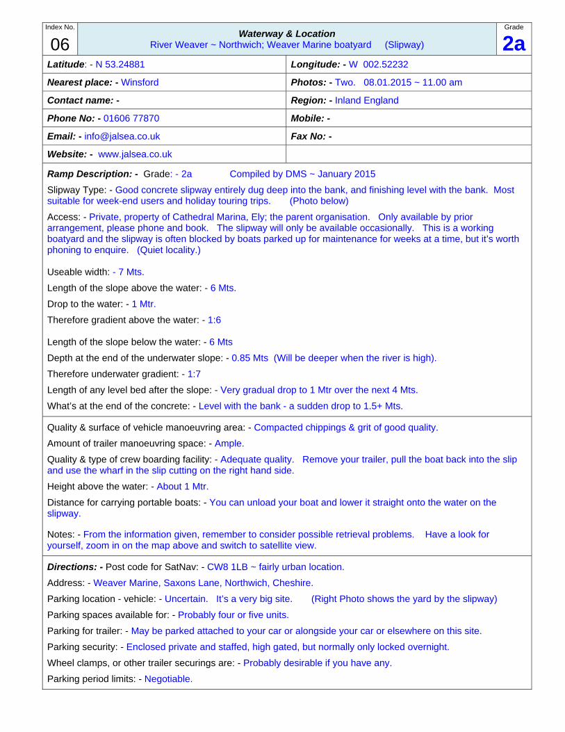
Adequate for: - Residential, long and heavy cabin boats, between about 20ft and 30ft.
Good for: - Canoes, dinghies, small inflatables, other portable boats with paddles; and portable RIB's, heavy dinghies, and other low height boats with engines.
Local facilities on-site: -
Water tap, Elsan disposal, rubbish disposal, toilets, showers, Calor gas, chandlery, engine repairs, launderette, other, overnight moorings
Nearby: -
Petrol: - Unknown. Nearest bus stop/train station: - Unknown. Camp site for canoeists: - Unknown. Supermarket: - Unknown. Other: - Unknown. Restaurant: - Unknown. Shops: - Unknown. Pub with food: - Unknown.
Charges: -
Boating licence: - You will need a C&RT licence to use the river. A variety of these are available from: - www.canalrivertrust.org.uk/boating/licensing. (Some canoeists may have an alternative permit.)
Slipping cost each way: - Please phone and enquire.
Group & individual portable boat launching each way: - Enquire
Vehicle Parking: - Enquire.
Trailer Parking: - Enquire.
Navigational Hazards:-
Dangerous currents after heavy rain.
The date of the pricing above & photo/s below is: - January 2015
Index No.
07 Waterway & Location
River Weaver ~ Northwich; Bickley Close
Grade
1cLatitude: - N 53.24714 Longitude: - W 002.52190
Nearest place: - Northwich Photos: - Two. 05.01.2015 ~ 14.30
Contact name: - N/A Region: - Inland England
Phone No: - N/A Mobile: - N/A
Email: - No entries Fax No (Email): - None.
Website: - N/A
Ramp Description: - Grade: - 1c Compiled by DMS ~ January 2015
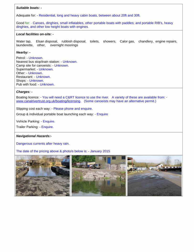
Not a slipway: - A good towpath grass bank Landing place with concrete edges, covered with turf and weeds. Suitable for one day or week-end boating for all users. Use the places where fishermen have cleared the turf and weeks off the concrete. (Left photo below)
Access and availability: - Public unrestricted free usage, belongs to the navigation and available any time during daylight hours.
Drop height to the water: - About 10 cm.
Amount of boat manoeuvring space: - Ample.
Distance from vehicle to the water: - About 15 Mts. Depending on where you park.
Quality, surface, and description of boat carrying route: - Small boats can be carried from the car park through the gap at the side of the barrier, (Right photo), and along the excellent hard surfaced path and across the 1 Mtr of rough grass to a suitable section of concrete bank edge. Large boats will need to be carried through the gap in the middle of the car park fence and down the rough grass slope to the towpath and bank edge. (Center photo).
Notes: - Have a look for yourself, zoom in on the map above and switch to satellite view.
Directions: - Post code for SatNav: - CW9 8TJ ~ urban location.
Address: - Bickley Close, Northwich, Cheshire.
Parking location for vehicle: - On the large excellent large asphalt car park at the end of Bickley Close. Keep driving forward – past the end of the houses on your right, and onto the car park.. (Right photo)
Parking spaces available: - Four or five cars.
Options for trailers: - May be parked attached to your car or alongside or close to your car, there may only be room for the odd single trailer.
Parking security: - Enclosed public car park, unstaffed and with no gates or barrier.
Wheel clamps, or other trailer securings are: - Strongly recommended if you have any and use a trailer.
Parking period limits: - Unrestricted.
Ramp Type: -
Good for: - Canoes, kayaks, dinghies, small inflatables, other portable boats with paddles; and also portable RIB's, heavy dinghies, and other low height boats with engines as long as you can carry them.
Local facilities on-site: -
None known.
Water tap: - Unknown. Rubbish disposal: - Unknown. Toilets: - Unknown. Showers: - Unknown. Other: - Unknown.
Nearby: -
Pub with food: - Unknown. Shops: - Unknown. Supermarket: - Unknown. Camp site: - Unknown. Nearest bus stop/train station: - Unknown. Other: - Unknown.
Charges: -
Boating licence: - You will need a C&RT licence to use the river. A variety of these are available from: - www.canalrivertrust.org.uk/boating/licensing (Some canoeists may have an alternative permit)
Boat launching each way: - Free.
Vehicle & trailer parking: - Free.
Navigational Hazards:-
Dangerous currents after heavy rain.
The date of the photo/s below is: - January 2015.
Index No.
08 Waterway & Location
River Weaver ~ Hartford; Vale Royal Locks
Grade
1bLatitude: - N 53.23828 Longitude: - W 002.53239
Nearest place: - Hartford Photos: - Three. 12.01.2015 ~ 10.45 am
Contact name: - N/A Region: - Inland England
Phone No: - N/A Mobile: - N/A
Email: - No entries Fax No (Email): - None.
Website: - N/A
Ramp Description: - Grade: - 1b Compiled by DMS ~ January 2015
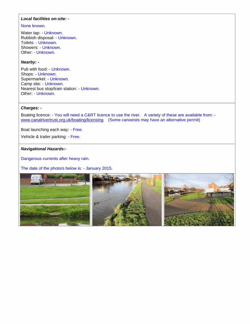
Not a slipway: - An excellent footpath grass bank Landing Place with heavy steel piled edging, covered with turf. Suitable for one day or week-end boating and long touring trips for all users. (Left photo below)
Access and availability: - Public unrestricted free usage, belongs to the navigation and available any time during daylight hours. (Very quiet locality). Drop height to the water: - About 30 cm.
Amount of boat manoeuvring space: - Ample.
Distance from vehicle to the water: - About 25 Mts, depending on where you park.
Quality, surface, and description of boat carrying route: - From your parking place carry your boat along the chippings and grit track back towards the bridge. As you reach the bridge turn left onto the footpath, then immediately right down the gentle slope to the 1 Mtr wide fairly level landing alongside the bridge. (Center photo).
Notes: - Have a look for yourself, zoom in on the map above and switch to satellite view. Having launched go under the bridge to join the main river channel, the headroom under the bridge is about 1.5 Mts.
Directions: - Post code for SatNav: - No post code, use co-ordinates ~ very rural location.
Address: - Vale Royal locks, Vale Royal Drive, Hartford, Northwich, Cheshire.
Go to the co-ordinates on the A556 dual carriageway and turn left down Vale Royal Drive, a narrow lane. An old sign at the start says ‘Private Road – Northwich Anglers’, but ignore this as it also goes to the locks. Turn sharp left at the locked golf club gate, cross the bridge, and the Landing Place is immediately on your right. Avoid all the heathland on the left, which is signed ‘Private- Northwich Anglers’.
Parking location for vehicle: - On the heathland to the right of the track, just past the tree. (Right photo)
Parking spaces available: - Plenty of space.
Options for trailers: - May be parked attached to your car or alongside or close to your car, depending on the available space.
Parking security: - Open public space in clear view of anyone passing, but the locality is so quiet these will probably all be fishermen. The locks are in sight and there’s a lock keeper on duty. In summer he’ll be at his post so ask him to keep an eye on your car, he may be very helpful and offer some good advice.
Wheel clamps, or other trailer securings are: - Suggested, if you have any and use a trailer.
Parking period limits: - Unrestricted.

Ramp Type: -
Excellent for: - Canoes, kayaks, dinghies, small inflatables, other portable boats with paddles; and also portable RIB's, heavy dinghies, and other low height boats with engines as long as you can carry them. You may have to lift your engine when crossing the shallows as you join the main river channel.
Local facilities on-site: -
None known.
Water tap: - Unknown. Rubbish disposal: - Unknown. Toilets: - Unknown.
Nearby: -
Camp site: - Unknown. Other: - Unknown.
Charges: -
Boating licence: - You will need a C&RT licence to use the river. A variety of these are available from: - www.canalrivertrust.org.uk/boating/licensing (Some canoeists may have an alternative permit)
Boat launching each way: - Free.
Vehicle & trailer parking: - Free.
Navigational Hazards:-
Dangerous currents after heavy rain.
The date of the photo/s below is: - January 2015.
Index No.
09 Waterway & Location
River Weaver ~ Weaver Way car park (Landing)
Grade
2bLatitude: - N 53.214866 Longitude: - W 002.523627
Nearest place: - Winsord Photo’s: - Two
Contact name: - N/A Region: - Northern England
Phone No: - N/A Mobile: -
Email: - No entries Fax No: - Email: -
Website: -
Ramp Description: - Grade: - 2b Updated by DMS ~ June 2013
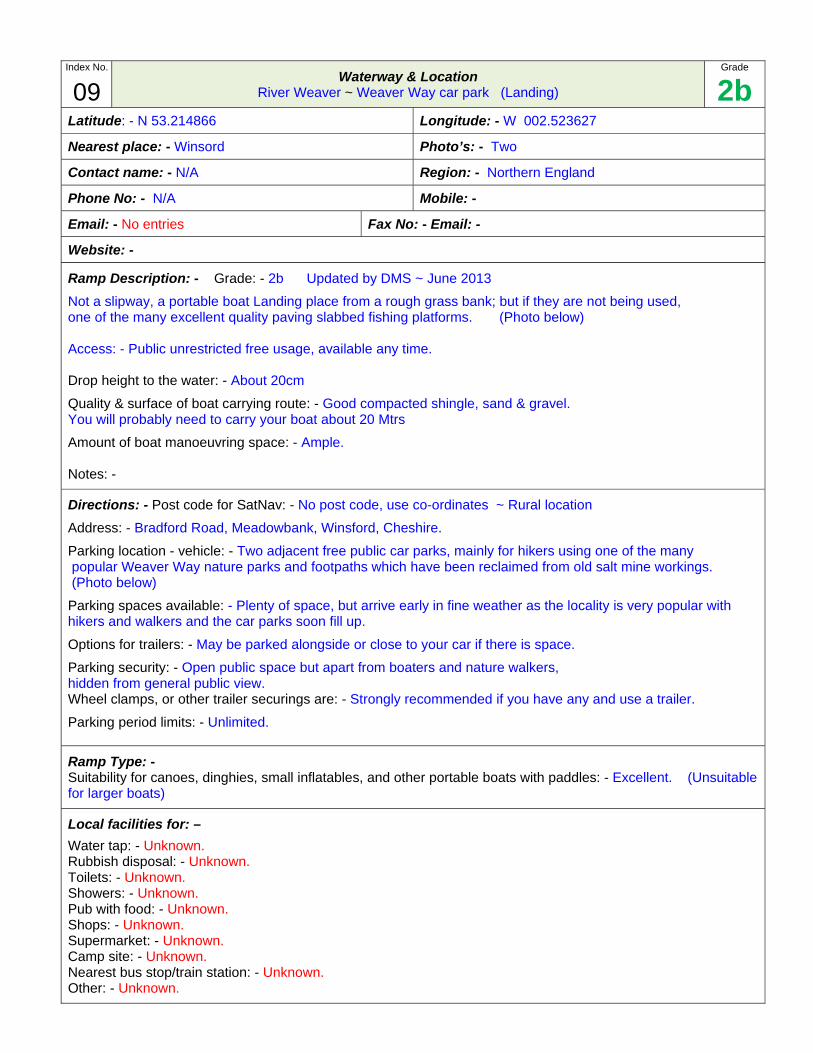
Not a slipway, a portable boat Landing place from a rough grass bank; but if they are not being used, one of the many excellent quality paving slabbed fishing platforms. (Photo below)
Access: - Public unrestricted free usage, available any time.
Drop height to the water: - About 20cm
Quality & surface of boat carrying route: - Good compacted shingle, sand & gravel. You will probably need to carry your boat about 20 Mtrs
Amount of boat manoeuvring space: - Ample.
Notes: -
Directions: - Post code for SatNav: - No post code, use co-ordinates ~ Rural location
Address: - Bradford Road, Meadowbank, Winsford, Cheshire.
Parking location - vehicle: - Two adjacent free public car parks, mainly for hikers using one of the many popular Weaver Way nature parks and footpaths which have been reclaimed from old salt mine workings. (Photo below)
Parking spaces available: - Plenty of space, but arrive early in fine weather as the locality is very popular with hikers and walkers and the car parks soon fill up.
Options for trailers: - May be parked alongside or close to your car if there is space.
Parking security: - Open public space but apart from boaters and nature walkers, hidden from general public view. Wheel clamps, or other trailer securings are: - Strongly recommended if you have any and use a trailer.
Parking period limits: - Unlimited.
Ramp Type: - Suitability for canoes, dinghies, small inflatables, and other portable boats with paddles: - Excellent. (Unsuitable for larger boats)
Local facilities for: –
Water tap: - Unknown. Rubbish disposal: - Unknown. Toilets: - Unknown. Showers: - Unknown. Pub with food: - Unknown. Shops: - Unknown. Supermarket: - Unknown. Camp site: - Unknown. Nearest bus stop/train station: - Unknown. Other: - Unknown.
Charges: -
Boating licence: - You will need a C&RT licence to use the river, or some alternative. A variety of these are available from: - www.canalrivertrust.org.uk/boating/licensing
Boat launching each way: - Free.
Parking cost: - Free.
Navigational Hazards:-
None known.
The date of the pricing above & photo/s below is: - January 2015
Index No.
10 Waterway & Location
River Weaver ~ Winsford; Red Lion Hotel (Landing)
Grade
2bLatitude: - N 53.19323 Longitude: - W 002.51665
Nearest place: - Winsford Photos: - Two. 12.01.2015 ~ 12.00 noon
Contact name: - Region: - Inland England
Phone No: - 01606 552285 Mobile: -
Email: - No entries Fax No (Email): - [email protected]
Website: - www.thered.biz
Ramp Description: - Grade: - 2b Compiled by DMS ~ January 2015
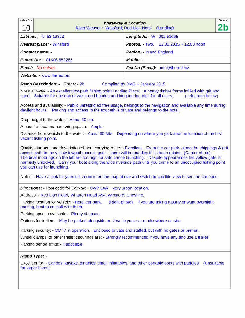
Not a slipway: - An excellent towpath fishing point Landing Place. A heavy timber frame infilled with grit and sand. Suitable for one day or week-end boating and long touring trips for all users. (Left photo below)
Access and availability: - Public unrestricted free usage, belongs to the navigation and available any time during daylight hours. Parking and access to the towpath is private and belongs to the hotel.
Drop height to the water: - About 30 cm.
Amount of boat manoeuvring space: - Ample.
Distance from vehicle to the water: - About 60 Mts. Depending on where you park and the location of the first vacant fishing point.
Quality, surface, and description of boat carrying route: - Excellent. From the car park, along the chippings & grit access path to the yellow towpath access gate – there will be puddles if it’s been raining, (Center photo). The boat moorings on the left are too high for safe canoe launching. Despite appearances the yellow gate is normally unlocked. Carry your boat along the wide riverside path until you come to an unoccupied fishing point you can use for launching.
Notes: - Have a look for yourself, zoom in on the map above and switch to satellite view to see the car park.
Directions: - Post code for SatNav: - CW7 3AA ~ very urban location.
Address: - Red Lion Hotel, Wharton Road A54, Winsford, Cheshire.
Parking location for vehicle: - Hotel car park. (Right photo). If you are taking a party or want overnight parking, best to consult with them.
Parking spaces available: - Plenty of space.
Options for trailers: - May be parked alongside or close to your car or elsewhere on site.
Parking security: - CCTV in operation. Enclosed private and staffed, but with no gates or barrier.
Wheel clamps, or other trailer securings are: - Strongly recommended if you have any and use a trailer.
Parking period limits: - Negotiable.
Ramp Type: -
Excellent for: - Canoes, kayaks, dinghies, small inflatables, and other portable boats with paddles. (Unsuitable for larger boats)
Local facilities on-site: -
Water tap: - Ask at the hotel. Rubbish disposal: - Ask at the hotel. Toilets: - In the hotel. Showers: - Unknown. Accommodation: - Book into the hotel. Other: - Unknown.
Nearby: -
Pub with food: - The hotel. Shops: - Unknown. Supermarket: - Unknown. Camp site: - Unknown. Nearest bus stop/train station: - Unknown. Other: - Unknown.
Charges: -
Boating licence: - You will need a C&RT licence to use the river. A variety of these are available from: - www.canalrivertrust.org.uk/boating/licensing (Some canoeists may have an alternative permit)
Boat launching each way: - Free.
Vehicle & trailer parking: - Free.
Navigational Hazards:-
Dangerous currents after heavy rain.
The date of the photo/s below is: - January 2015.
Index No.
11 Waterway & Location
River Weaver ~ Winsford Bottom Flash (Slipway)
Grades
4a Latitude: - N 53.19041 Longitude: - W 002.51697
Nearest place: - Winsford Photo’s: - Three
Contact name: - Jim & Kath Oakes (Long term parking) Region: - Northern England
Phone No: - 0606 554491 Mobile: -
Email: - Fax No: -
Website: -
Ramp Description: - Grade: - 4d Updated by DMS ~ June 2013
Slipway access: - Public, owned by Cheshire West & Chester Council, and unrestricted within the parking limits.
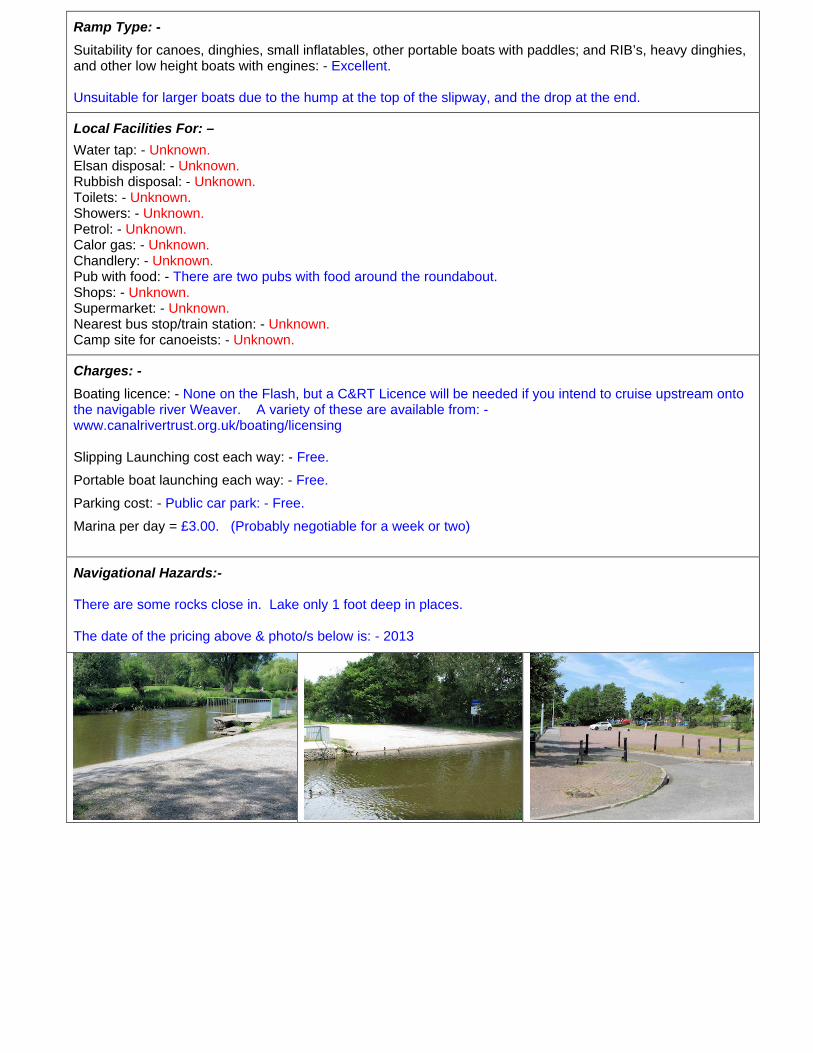
Type: - Good concrete slipway ~ built over the bank. (Photo’s below)
Slipway useable width: - 14 Mts
Length of the slope above the water: - 2.5 Mts
Drop to the water: - 50cm
Gradient above the water: - 1:5
Length of the slope below the water: - 2.5 Mts
Depth at the end of the underwater slope: - 50cm
Underwater gradient: - 1:5
What’s at the end of the concrete: - Sudden drop to 70cm, then a gradual deepening to beyond 1 Mtr.
Quality & surface of vehicle manoeuvring area: - Compacted gravel & grit of excellent quality.
Amount of manoeuvring space: - Enough and quite easy to use.
Crew boarding facility: - 50 Mtr long concrete wharf, difficult to use as it’s protected by a 1 Mtr high substantial steel fence to prevent children falling in the water. Canoeists can use the 20cm high rough concrete blocks by the wharf end. (See photo below)
Quality of boarding facility: - Adequate, if you can climb over the fence to use it.
Height above the water: - 60cm
Distance for carrying portable boats: - You can unload your boat and lower it straight onto the water.
Notes: - Parts of the lake are only 1 foot deep and keep away from south of river. There is lots of silt you can get stuck on. Follow river North for good scenery. Go slow, or the fishermen may catapult bait at you.
Directions: - Post code for SatNav: - CW7 3DD ~ Semi-urban location
Address: - Take the A54 to Winsford; there is a car park and a wooden hut just as you get to a roundabout. Go in to the car park and the slip is in front of you.
Parking location: - On the right of the slipway is a public car park for day parking. (Photo below) On the left is The Dock House, Caravan & Boat Marina, run by Jim & Kath Oakes for long term parking, and this launching site is graded on the assumption you will be parking here.
Parking spaces available: - Lots of space on the public car park. Three or four units in the marina.
Parking for trailer: - Unless it’s very busy, it may be parked attached to your car in either location.
Parking security: - The public vehicle park is an open public space in clear view of anyone passing. The marina is enclosed, gated with a low gate but only locked overnight, however most of the site is hidden from public view.
Wheel clamps, or other trailer securings are: - Strongly recommended if you have any and use a trailer.
Parking period limits: - Public car park 14 hours. In the marina it’s negotiable.
(Only suitable for small trailers)
Ramp Type: -
Suitability for canoes, dinghies, small inflatables, other portable boats with paddles; and RIB’s, heavy dinghies, and other low height boats with engines: - Excellent.
Unsuitable for larger boats due to the hump at the top of the slipway, and the drop at the end.
Local Facilities For: –
Water tap: - Unknown. Elsan disposal: - Unknown. Rubbish disposal: - Unknown. Toilets: - Unknown. Showers: - Unknown. Petrol: - Unknown. Calor gas: - Unknown. Chandlery: - Unknown. Pub with food: - There are two pubs with food around the roundabout. Shops: - Unknown. Supermarket: - Unknown. Nearest bus stop/train station: - Unknown. Camp site for canoeists: - Unknown.
Charges: -
Boating licence: - None on the Flash, but a C&RT Licence will be needed if you intend to cruise upstream onto the navigable river Weaver. A variety of these are available from: - www.canalrivertrust.org.uk/boating/licensing
Slipping Launching cost each way: - Free.
Portable boat launching each way: - Free.
Parking cost: - Public car park: - Free.
Marina per day = £3.00. (Probably negotiable for a week or two)
Navigational Hazards:-
There are some rocks close in. Lake only 1 foot deep in places.
The date of the pricing above & photo/s below is: - 2013