Embed Size (px)
Citation preview
Rivers

• As rivers carve across the land they not only provide water and habitats for special ecosystems, they change the land itself. As water flow they
• ERODE the land. In Winnipeg, the erosion of riverbank property is a huge concern. What are some ways in which riverbank erosion can be reduced?
• Control river levels• line river banks with concrete/rocks • Divert water (floodway)• Slowing boats – no wake zones• Plant trees/shrubs on banks
• Create unique landforms such as “peninsulas” (land surrounded by water on three sides) as the river MEANDERS or wanders. The water eroding softer land causes this.

Oxbow Lakes
• Create an OXBOW LAKE which is a “U-shaped” lake or pond formed when a river’s meander is cut off from the river.
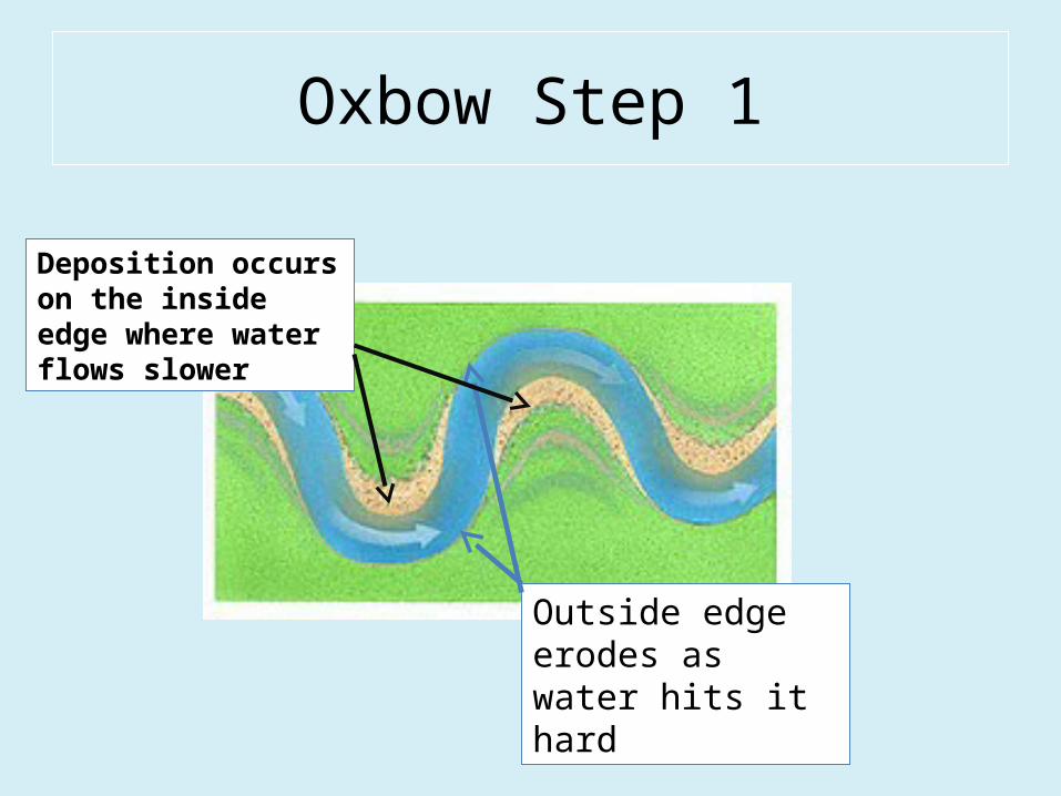
Oxbow Step 1
Outside edge erodes as water hits it hard
Deposition occurs on the inside edge where water flows slower

Oxbow Step 2
New channel begins to form
More sediments are deposited in old channel

Oxbow Step 3
Old channel is completely cut off
Old meander is left as an “Oxbow Lake”

River Deltas
• Creates ALLUVIAL DEPOSITS and DELTAS as the water deposits the minerals it eroded on its journey. Deltas are fan-shaped land forms found at the mouth of rivers (where the river meets a lake, sea, or ocean). The NILE River Delta may be one of the most famous river deltas in the world and was and is important to Egyptian life.
• Draw a triangle around the green delta area formed when the Nile deposits the rich, fertile sediments eroded from the African continent.

River Deltas
• This land is FERTILE and productive agriculturally!• Delta () is the Greek letter D and is in the shape of a triangle!
• In Manitoba the rivers flowing into Lake Winnipeg and Lake Manitoba form marshy deltas, areas that are important for:– Wildlife habitat (both land and aquatic)– Cleaning/purifying water entering the lakes

Old vs. Young Rivers

Old vs. Young Rivers
• Use the table below to compare and contrast young and old rivers.
YOUNG OLD
Fast Slow
Straighter Windy (meandering)
Energetic Less energy
Can move large boulders Move small sediments
Narrower Wider
Cleaner water More sediment/ muddier

The RED River
• As the Red River began only after Lake Agassiz drained some 10000 years ago, it is considered to be a young river. But it behaves like an older river because it has a low flow rate with little energy!
• The areas on the sides of the river create a river valley or a flood plain. The Red River’s flood plain is wide and shallow, much like a gentle plate.
• This creates many problems with flooding.

The RED River Flooding
• Other factors leading to flooding in southern Manitoba include:
Flat, wide flood plain Slow flow
Flows north – mouth is still frozen when south begins to melt
Ice jams
Heavy snow pack Frozen land (no absorption)
Quick thaw Heavy spring rains
Human influence – dams, dikes, levees – keep water from moving naturally
Global warming/climate change

Flood Protection
• People in southern Manitoba, and especially in Winnipeg, are always concerned about flooding.
Small Scale Large Scale
In use Flood insuranceSand bagsRaise buildingsPumpsMore/bigger ditchesFlood walls/levees
FloodwaysDamsClearing out the river bed
Future Ideas Building large holes into the river bedSuper ice/water heaters