Embed Size (px)
Citation preview

April 4, 2008 1

April 4, 2008 2
Daryl Jackson, owner of IrisResources, Inc., has been in water process projects since 1993. He and his brothers developed a process called “Hydro-Evacuation” in May of 1996. This process avoids the strip mine process of mining coal, leaving the land virtually undisturbed.

April 4, 2008 3
Daryl also controls brine water gathered from CBM wells, Daryl also controls brine water gathered from CBM wells, testing each load for tds. He uses the water pumped testing each load for tds. He uses the water pumped from the brine water tanks, streams the water while from the brine water tanks, streams the water while
dumping fly ash to form a slurry. Once level has dumping fly ash to form a slurry. Once level has occurred he adds 3 ft. of topsoil, thus reclamation has occurred he adds 3 ft. of topsoil, thus reclamation has
occurred. His brother now lives and raises horses on the occurred. His brother now lives and raises horses on the completed project. completed project.
Completed Project Reclamations ProjectCompleted Project Reclamations Project
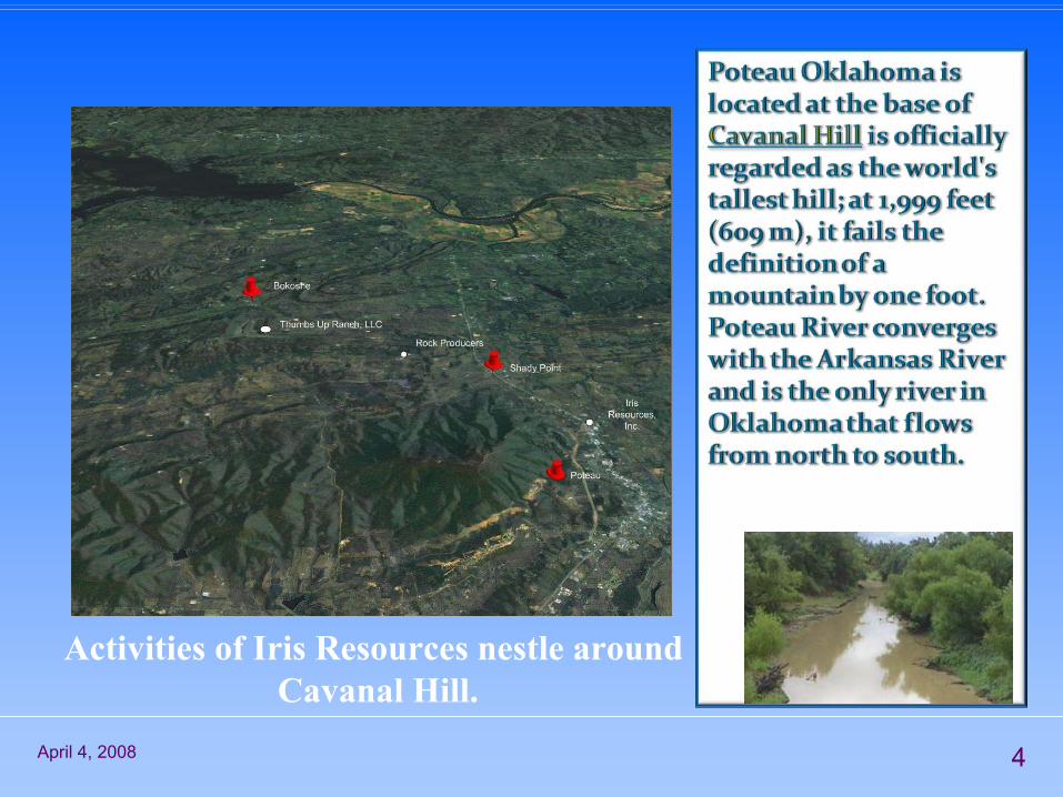
April 4, 2008 4
Activities of Iris Resources nestle aroundCavanal Hill.

April 4, 2008 5
Wister Lake lies to the south of Poteau, on the Poteau River and spans 65490 acre-feet.Wister Lake lies to the south of Poteau, on the Poteau River and spans 65490 acre-feet.
Robert S. Kerr Reservoir is located on theArkansas River in Sequoyah, Le Flore, Haskell,
and Muskogee Counties in the state of Oklahoma, USA. The reservoir is impounded by Robert S. Kerr Lock and Dam at river mile336.2 (km 541.1) on the Arkansas River, just afew miles below its confluence with theCanadian River. The lock and dam are part of the McClellan-Kerr Arkansas River Navigation System, which provides for barge navigation on the Arkansas River and some of its tributaries. The U.S. Army Corps of Engineers maintains the locks and navigation system.

April 4, 2008 6
This is an overflow of one of the localLake reservoirs.
More than 500 named creeks and rivers make up Oklahoma's waterways, and with 200 lakes created by dams, it holds the highest number of
artificial reservoirs in the nation

April 4, 2008 7
This stream flows down the north face of Cavanal Hill. It gully washes in the spring and after strong rainstorms. During the warm months it provides cool water for all and where it pools
there are some perch and young bass.
In high water, the “tube shoot” is popular in the area.

April 4, 2008 8
Let me take you through a short ¼ mile trip of Poteau River. Let me take you through a short ¼ mile trip of Poteau River. The streams coming down the hills and mountains are The streams coming down the hills and mountains are
clean enough, but it feeds into the Poteau River, and that clean enough, but it feeds into the Poteau River, and that is not. People and industry have struck with trash and is not. People and industry have struck with trash and
pollution.pollution.

April 4, 2008 9
Tires and trash line the water for a ¼ mile.Tires and trash line the water for a ¼ mile.

April 4, 2008 10
This is runoff from a factory up on the bank. Piled rocks protecThis is runoff from a factory up on the bank. Piled rocks protect t the entrance to the river and then above piled brush is to the entrance to the river and then above piled brush is to
disguise it.disguise it.

April 4, 2008 11
This, and much more, lies above the brush pile in This, and much more, lies above the brush pile in different locations…different locations…
And the factory lies directly above it all.

April 4, 2008 12
Considering the condition of this ¼ mile strip Considering the condition of this ¼ mile strip of river, it’s disheartening to know that the of river, it’s disheartening to know that the
Poteau River is 206 km/128 mi long. Rising in Poteau River is 206 km/128 mi long. Rising in Scott County, Arkansas, it flows westward Scott County, Arkansas, it flows westward into Oklahoma, south of Heavener, before into Oklahoma, south of Heavener, before turning northeast to flow past the town of turning northeast to flow past the town of Poteau and join the Arkansas River at Fort Poteau and join the Arkansas River at Fort
Smith.Smith.

April 4, 2008 13
Arkansas River and Poteau River Converge

April 4, 2008 14
Blue Heron flying low over the Arkansas River
Please visit your Rivers and Creeks….and discover the Treasures.


![REGULATION (EU) N. 2016/2281 FOR COMFORT CHILLERS...For air-to-water comfort chillers: air flow rate, outdoor measured [m³/h] 91476,00 For water/brine-to-water chillers: Rated brine](https://img.pdfslide.net/doc/110x75/611fcbc5d322f72562008dea/regulation-eu-n-20162281-for-comfort-chillers-for-air-to-water-comfort-chillers.jpg)