Embed Size (px)
Citation preview
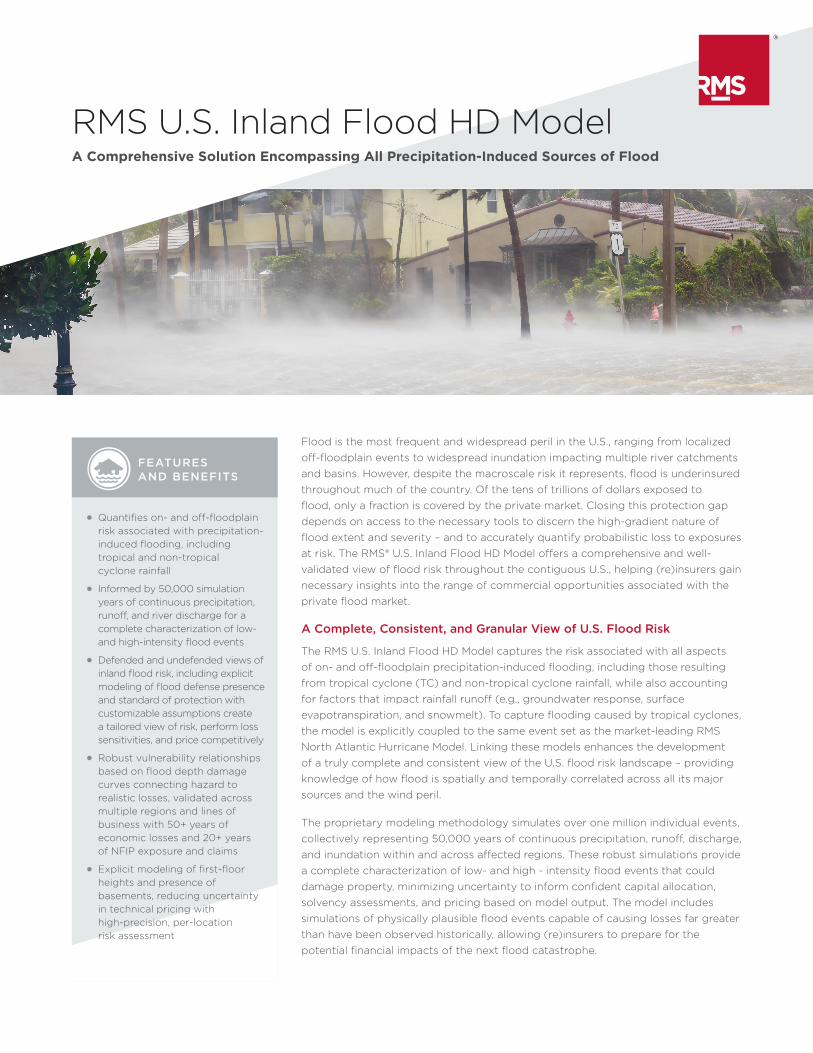
FEATURES AND BENEFITS
RMS U.S. Inland Flood HD ModelA Comprehensive Solution Encompassing All Precipitation-Induced Sources of Flood
Flood is the most frequent and widespread peril in the U.S., ranging from localized off-floodplain events to widespread inundation impacting multiple river catchments and basins. However, despite the macroscale risk it represents, flood is underinsured throughout much of the country. Of the tens of trillions of dollars exposed to flood, only a fraction is covered by the private market. Closing this protection gap depends on access to the necessary tools to discern the high-gradient nature of flood extent and severity – and to accurately quantify probabilistic loss to exposures at risk. The RMS® U.S. Inland Flood HD Model offers a comprehensive and well-validated view of flood risk throughout the contiguous U.S., helping (re)insurers gain necessary insights into the range of commercial opportunities associated with the private flood market.
A Complete, Consistent, and Granular View of U.S. Flood Risk
The RMS U.S. Inland Flood HD Model captures the risk associated with all aspects of on- and off-floodplain precipitation-induced flooding, including those resulting from tropical cyclone (TC) and non-tropical cyclone rainfall, while also accounting for factors that impact rainfall runoff (e.g., groundwater response, surface evapotranspiration, and snowmelt). To capture flooding caused by tropical cyclones, the model is explicitly coupled to the same event set as the market-leading RMS North Atlantic Hurricane Model. Linking these models enhances the development of a truly complete and consistent view of the U.S. flood risk landscape – providing knowledge of how flood is spatially and temporally correlated across all its major sources and the wind peril.
The proprietary modeling methodology simulates over one million individual events, collectively representing 50,000 years of continuous precipitation, runoff, discharge, and inundation within and across affected regions. These robust simulations provide a complete characterization of low- and high - intensity flood events that could damage property, minimizing uncertainty to inform confident capital allocation, solvency assessments, and pricing based on model output. The model includes simulations of physically plausible flood events capable of causing losses far greater than have been observed historically, allowing (re)insurers to prepare for the potential financial impacts of the next flood catastrophe.
• Quantifies on- and off-floodplain risk associated with precipitation-induced flooding, including tropical and non-tropical cyclone rainfall
• Informed by 50,000 simulation years of continuous precipitation, runoff, and river discharge for a complete characterization of low- and high-intensity flood events
• Defended and undefended views of inland flood risk, including explicit modeling of flood defense presence and standard of protection with customizable assumptions create a tailored view of risk, perform loss sensitivities, and price competitively
• Robust vulnerability relationships based on flood depth damage curves connecting hazard to realistic losses, validated across multiple regions and lines of business with 50+ years of economic losses and 20+ years of NFIP exposure and claims
• Explicit modeling of first-floor heights and presence of basements, reducing uncertainty in technical pricing with high-precision, per-location risk assessment

Facilitates Development of Comprehensive U.S. Flood Business Strategies
As the private U.S. market continues to grow, the RMS U.S. Inland Flood HD Model will support favorable risk selection, actuarially sound ratemaking, and effective risk transfer decisions, while informing the reinsurance and capital management of a profitable flood portfolio. The model discerns hazard and loss characteristics at fine resolution, allowing (re)insurers to properly differentiate locations at risk, identify risk concentrations, and inform territory definitions within and across regions at a resolution required for such a high-gradient peril.
High-resolution hazard and loss data layers accompany the probabilistic model and utilize the same underlying methodology as the model. Together, the model and data solutions enable a confident and flexible U.S. flood business strategy from location-level underwriting and pricing through to portfolio, reinsurance, and capital management decisions.
Reflect the Impacts of Flood Mitigation Beyond Publicly Available Data
The RMS U.S. Inland Flood HD Model provides defended and undefended views of flood risk, allowing the market to quantify the sensitivities and impacts of various flood mitigation efforts and failure scenarios and facilitating appropriate flood risk selection, pricing, and portfolio growth decisions throughout the U.S.
FEATURES AND BENEFITS CONTINUED
• Financial model supports innovative products based on sound understanding of cross-peril correlation, duration of events, and multiple events extensively calibrated to USGS river discharge and depth data, ensuring suitability for detailed risk assessment and location-level underwriting
• Informs effective underwriting, pricing, risk selection and differentiation, portfolio management, and risk transfer decisions to develop or grow a profitable flood portfolio
FLASH
PLUVIAL/SURFACE
COASTAL/STORM SURGE
BACKWATER
Heavy or excessive rainfall causes rapid flooding of low-lying areas within minutes or a few hours (typically less than six hours): also possible with a sudden release of water from a levee/dam (failure), ice jam, or other debris
that is not absorbed or routed for drainage that flood low-lying areas or impermeable urban surfaces
Low-pressure weather systems over the ocean elevate sea levels above the normal tidal limit and flood areas of lower elevation near the coast, often exacerbated by heavy rainfall and onshore winds
Upstream flooding caused by downstream conditions, such as channel restriction and/or high flow at a confluence of streams
GROUNDWATERUnderground water levels rise above normal and approach the surface, usually caused by prolonged periods of rainfall, which can last for several weeks or months
Excessive rainfall/snowmelt over an extended period of time causes a river to exceed its capacity and overtop its banks
FLUVIAL/RIVERINE

SUPPORTED SOLUTIONS
• Available as an HD model on the RMS(one)® platform for a full probabilistic solution
• Flood Hazard Data and Risk Score Data products available through the RMS(one) API to enhance workflows at the point of underwriting
• Global Client Support services ensure continuous availability of knowledgeable support staff, fulfillment and deployment services, RMS experts, and product and industry training
• Access to comprehensive, transparent documentation, including model methodology and model validation
• When a catastrophe occurs, the RMS Event Response Team provides accurate accumulation, modeling, and loss estimation information and guidance to clients and the marketplace
Understanding the presence and protection level of flood defenses are a critical part of this process. However, more than 85 percent of the modeled U.S. river network does not have defense information available. Modeling flood risk without a complete view of flood mitigation measures can bias modeled losses, potentially leading to overly conservative views of flood risk and an inefficient use of capital.
To address this gap, RMS incorporates the latest-known levee information from the U.S. Army Corps of Engineers (USACE) National Levee Database and the Federal Emergency Management Agency (FEMA) National Flood Hazard Layers. In addition, RMS utilizes a proprietary stochastic modeling technique that accounts for the likely presence and standard of protection of defenses along the entire modeled river network. The model provides users with the flexibility to adjust defense assumptions when additional information about flood mitigation is known to generate a tailored view of risk.
Minimize Uncertainty with a Comprehensive Suite of Flood Vulnerability Curves
With over 20 years of experience modeling flood risk in the U.S., RMS has developed, calibrated, and validated an extensive suite of water-based damage curves across numerous primary and secondary risk classifications. Building on that expertise, the model’s vulnerability component employs a physics-based analytical flood damage model. This advanced framework of simulation-based vulnerability functions captures the impacts of flood depth, flow velocity, and potential debris impacts on a structure’s risk profile (above and below grade). The model enables users to differentiate risk appropriately and establish accurate risk loadings across hundreds of combinations of building characteristics. An ancillary Industrial Facilities Model (IFM) provides accurate coding for specialized exposures within the industrial lines of business.
Structure Complex Policy Terms
Long-lasting flood events in the U.S. can contribute to a large portion of average annual loss and tail risk metrics. Developing an accurate view of flood risk as an event evolves is dependent on quantifying the cumulative impacts of hazard and vulnerability, in addition to understanding sensitivities around temporal definitions of coverage.
The RMS HD modeling methodology includes continuous temporal simulations, which capture intra- and interseasonal flood patterns, such as event clustering, seasonality, and antecedent conditions. With this approach, (re)insurers can accurately quantify the aggregate impacts of flooding and instill objective, data-driven structuring of multi-event, seasonal, or multi-year policies.
With the new RMS(one) financial model, the market can accurately define and quantify the impacts of time-based flood policy terms, such as hours clauses and aggregate covers. (Re)insurers can explore marginal gains and sensitivities to varying hours clause length for treaties, while also establishing preferred flood coverages for other flood policies and programs, such as flood sub-limits, per-risk treaties, and reinstatements. Furthermore, the HD modeling framework allows for customization of assumptions around the standard of protection of river defenses.
Find Out More
To learn more about the RMS U.S. Inland Flood HD Model, visit our website at www.rms.com or contact your RMS account representative.
©2018 Risk Management Solutions, Inc. RMS is
a registered trademark and the RMS logo is a
trademark of Risk Management Solutions, Inc.
All other trademarks are property of their
respective owners.
20180501
RMS is the world’s leading catastrophe risk modeling company. From earthquakes, hurricanes, and flood to terrorism, agriculture, and infectious diseases, RMS helps financial institutions and public agencies understand, quantify, and manage risk.
RMS7575 Gateway Blvd. Newark, CA 94560 USA
For sales inquiries: +1.510.505.2500 +44.20.7444.7600 [email protected] www.rms.com
YEAR LAUNCHED: 2018
GEOGRAPHIC COVERAGE: Contiguous U.S. (48 states), including the federal district of Washington, D.C.