Embed Size (px)
Citation preview
VOL. 1
ROAD AGENCY FORMATION UNIT
MINISTRY OF WORKS, HOUSING AND COMMUNICATION
KAMPALA-GAYAZA-EUGEMA-ZIROBWE-WOBULENZI ROAD
PACKAGE I: UPGRADING AND STRENGTHENING OF THE: KAMAPALA-GAYAZA-ZIROBWE ROAD
PACKAGE 11: UPGRADING TO PAVED (BITUMEN) STANDARD OF THE ZIROBWE-WOBULENZI ROAD
PHASE I1 : DETAILED ENGINEERING DESIGN
FINAL REPORT
VOLUME B.1.2/1
ENVIRONMENTAL IMPACT ASSESSMEiNT
Prepared by
PHOENIX ENGINEERING & RESEARCH LTD P 0 Box 28442
Plot 7, Summit View Road, Naguru - Kampala
November, 2003
Pub
lic D
iscl
osur
e A
utho
rized
Pub
lic D
iscl
osur
e A
utho
rized
Pub
lic D
iscl
osur
e A
utho
rized
Pub
lic D
iscl
osur
e A
utho
rized
Pub
lic D
iscl
osur
e A
utho
rized
Pub
lic D
iscl
osur
e A
utho
rized
Pub
lic D
iscl
osur
e A
utho
rized
Pub
lic D
iscl
osur
e A
utho
rized


ENYIROMENTAL IMPACT ASSESSMENT
TABLE OF CONTENTS
EXECUTIVE SUMMARY v
........................................................................................................ 1 INTRODUCTION 1
1.1 The Project ....................................................................................................... 1
...................... 1.2 Scope Of Work For Feasibility Study (Terms Of Reference) 1
1.3 Feasibility Study Final Report ........................................................................ 2
........................................................................................... 1.4 Work Carried Out 4
.......................................................................................... 2 PROJECT DESCRIPTION 5
2.1 The Project Works .......................................................................................... 5 .................. 2.1.1 Alignment Option A - Existing Alignment .. ........................ 6
.......................................... 2.1.2 Alignment Option B - Optimised Alignment 6 2.1.3 Alignment Option C - Deviations ........................................................... 7
2.2 Scope of the Study ....................................................................................... 8
2.3 Previous Reports ............................................................................................ 8
3 INSTITUTIONAL AND LEGAL FRAMEWORK OF EmRONMENTAL ................................................................................................................................ P0L.lCY 9
............................................................................................................ 3.1 Overview 9 -' 3.2 Institutional Framework ................................................................................ 10
3.2.1 National Environment Management Authority (NEMA) ......................... 10 .......................................................... 3.2.2 Environmental Liaison Unit (ELU) 10
3.2.3 The Uganda Land Commission ........................................................ 1 0 .................................................. 3.2.4 Non Government Organisations (NGO) 11
3.3 Environmental and Social Assessment Regulations ................................... 11 ...................................................................... 3.3.1 Environmental regulations 1 1
................................................................... 3.3.2 Social Laws and Regulations 11
4 ElLZlRONMENTAL SETTING: BASELRVE CONDITIONS ................................ 12 :
4.1 Location .......................................................................................................... 12
...................................................................... 4.2 The Biophysical Environment 12 ......................................................................................... 4.2.1 Topography 1 2
..................................................................................................... 4.2.2 Climate 12 .................................................................................... 4.2.3 Geology and Soils 13
4.2.4 Water ........................................................................................................ 13 4.2.5 Air Quality ............................................................................................ 1 3
-
EL4 Final Repod28-11-03 Phoenix
4.2.6 Vegetation ................................................................................................ 16 4.2.7 Fauna ......................................................................... ........................ 17
4.3 The Human Environment ............................................................................. 17 4.3.1 Population ........................................................................................... 17 4.3.2 Demographic Structure ........................................................................ 18 4.3.3 PopulationDensity ................................................................................... 18 4.3.4 Urban and Rural Population ................................................................ 1 8 . . .................................................................................. 4.3.5 Social Orgmsation 18
.......................................................................................... 4.3.6 Ethnic Groups 19 ....................................................................................... 4.3.7 Land Tenure 1 9
......................................... 4.3.8 Economic Activities and Standards of Living 20 ............................................................................................... 4.3.9 Agriculture 21
.................................................................................... 4.3.10 Animal Resources 21
......................................................... 4.4 Cultural Heritage in the Project Area 22
4.5 Administrative Arrangement ........................................................................ 22
4.6 Public Services ................................................................................................ 23 .............................................................................................. 4.6.1 Fuel Supply 23 ........................................................................................... 4.6.2 Water Supply 23 ............................................................................................ 4.6.3 Public Health 23
................................................................................... 4.6.4 HIVIAIDS Control 24 ......................................................... ........................................... 4.6.5 Schools i 24
............................................................ 4.6.6 Lack of Ancillary Road Facilities 24
4.7 The Existing Kampala-Gayaza-Zirobwe-Wobulenzi Road ....................... 26
4.8 Settlement Pattern Along the Road .............................................................. 31
........ 5 PROJECTALTERNATIWS AND ROAD STRUCTURE REQUIREMENT 33
5.1 Road Reserve Area (RRA) and Resettlement Approach .......................... 33
5.2 The Project Road: Realignment Options ..................................................... 35
6 EmRONMENTAL IMPACTS AND MITIGATION ............................................. 39
6.1 General ............................................................................................................ 39
6.2 Impact Evaluation Approach ....................................................................... 39
6.3 Environmental Impacts of the Existing Road ............................................. 41 ........................................................ 6.3.1 Health Effects Of Present Road Use 41
........................................................................ 6.3.2 Current Traffic Accidents 41
6.4 Planned Road Works ..................................................................................... 43
6.5 Traffic Growth Forecasts .............................................................................. 43 ........................................ 6.5.1 Impacts Of Road Works and Future Road Use 44
6.5.2 Short-term Negative Impacts of Road Works .......................................... 44 6.5.3 Short-term positive impacts of road works .............................................. 44 6.5.4 Long-Term Negative Impacts Of Road Works ........................................ 44
......................................... 6.5.5 Long-Term Positive Impacts Of Road Works 44 ..................... 6.5.6 Direct Impacts Of Future Road Use .. ............................ 45
................................................................................... 6.5.7 Negative Impacts : 45 6.5.8 Positive, Indirect Impacts Of Future Road Use ..................................... 45
............................................................ 6.5.9 Impacts and Mitigation Measures 45
. . EIA Final Repod28-11-03 11 Phoenix
Karnnala-Gayaza-Zirobwe-Wobulenzi Road EL4
....................................................................... 6.5.10 Biophysical Environment -46 ................................................................................ 6.5.1 1- Human Environment 49
............................................................. 7 ENylRONmNT MANAGEMENT PLAN 59
7.1 Context of the Plan ........................................................................................ 59
................... 7.2 Environment Management Plan : Phase 1 Project Execution 59 7.2.1 Final formulation of the environmental packages ................................... 59 7.2.2 Environmental and Social mitigation at the Implementation Stage: .... 61
......................................... 7.2.3 Monitoring and Responsibility: EWE' Phase 1 61
....................................... 7.3 Environment Management Plan Phase 1 Budget 62
7.4 Environment Management Plan: Phase 2 After Opening Road Upgrade63 7.4.1 Taffic Management ................................................................................ 63 7.4.2 Construction of Ancillary Infrastructures ............................................... 64
.. 7.4.3 Ecosystem Protection in the Road Influence Zone ................................ 64 ............................................ 7.4.4 Advised Benefit Enhancement Measures 64
....................................... 7.4.5 Phasing of the Environment Management Plan 65
................................ 8 DISPLACEMENT AND liWOL UNTAR Y SETTLEMENT 6 7 ...
8.1 Main Characteristics of Settlements along the Project Road .................... 67 ..................................................................................... 8.1.1 Expected impacts 67
............................................................. 8.1.2 Impact on land and cropped area 67 ........................................................................... 8.1.3 Impact on constructions 68
8.2 Recommended Mitigation Measures ............................................................ 70 ....................................................................... 8.2.1 Community participation -71
........................................................ 9 RESETTLEMENT IIMPACT ASSESSMENT. 72
9.1 Objective of the Resettlement Impact Assessment ..................................... 72 9.1.1 The Project Impact in respect to resettlement: ......................................... 72 9.1.3 Cutting of economic valuable trees ......................................................... 73
................................................................ 9.1.4 Loss of agricultural production 73 9.1.5 Displacement of stalls and demolition of Houses ................................... -73
................................................................. 9.1.6 Institutions and Organizations 73 9.1.7 Public Utilities and Infi-astructure ............................................................ 74 . . . ...................................................................................... 9.1.8 Land Acqu~sition 74
9.2 Infrastructure and Social Improvement ...................................................... 74
9.3 Consultation and participation of the population in the resettlement Activities ..................................................................................................................... 74
............................................................................ 9.4 Institutional Arrangement 75 ................................................................... 9.4.1 Sites Affected by the Project 75
........................................................................... 9.4.2 Entitlement Framework 75 9.4.3 Institutional Framework & Involvement of Local leaders ................ ....... 76 9.4.4 Implementation strategies of the plan ................................................ ....... 77 9.4.5 Payment for the lost property and Transparency ...................................... 81 9.4.6 Monitoring and Mitigation Measures ..................... .. ........................ 83
............................................................................... 9.5 Reporting Arrangements 84
9.6 Resettlement Implementation and Evaluation ...................... .. ................. 85
... EIA Final Reportn8-11-03 111 .Phoenix

Kampala-Gavaza-Zirobwe-Wobulenzi Road ELA
10 TOTALCOSTS ........................................................................................ . ................. 86
10.1 Cost of Environment Management Plan: Phase 1 ...................................... 86
10.2 Resettlement Costs ......................................................................................... 88
10.3 Total Cost of the Environment Management Plan and Resettlement ...... 90
11 CONCLUSION AND RECOMMENDA TIONS. .... . . . .. . . . . .. .. .. . . . .. .. . . .. . . .... . .. . .. .... ... . . .... 93
11.1 Conclusion ...................................................................................................... 93
11.2 Recommendations ....................................................................................... 93
APPENDIX A: REPORT ON PUBLIC CONSULTATION ACTIVITY
APPENDIX B: REPORT ON RESETTLEMENT CONSULTATION
APPENDIX C: STATISTICAL ABSTRACTS
APPENDIX D: BIBLIOGRAPHY
EIA Final Reporti28-11-03 iv Plzoenix

EXECUTIW SUMMARY
This Final version of the Environmental Impact Assessment Reports incorporates comments and recommendations issued by RAFU letters dated 11 October 2001 and October 2003. The EIA proposes alignment B on technical, economical and social aspects. This is furth.ermore at the light of the decision made by RAFU selecting Options B for all road sections ciomposing the Project Road the budgeted cost for environmental impact mitigation measures has been validated, whereas the resettlement cost has been detailed in the separate report Resettlement Action Plan (Package I, Part A, Volume 1) and (Package 11, part A, Volumel).
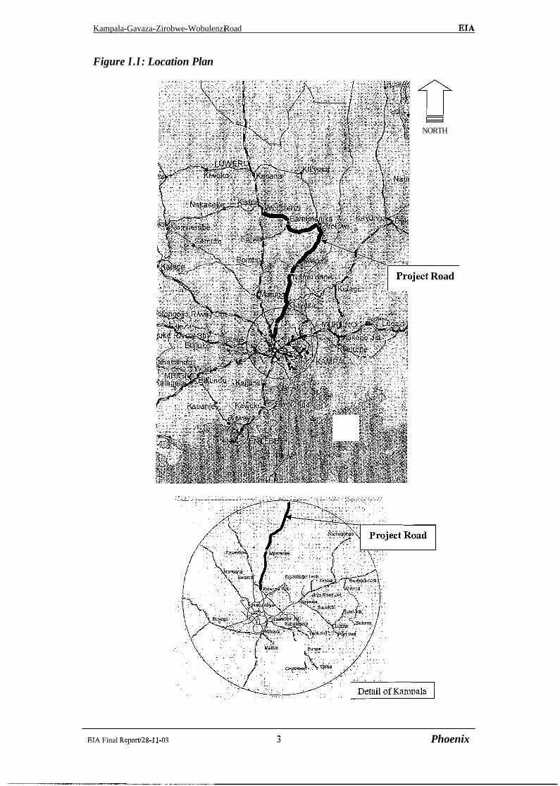
The Project Road lies in the districts of Kampala, Mpigi (now the recently folrmed Wakiso District) and Luwero. It extends north from Kampala to Gayaza (13 km, existing paved road), then continues north on a gravel road to Zirobwe (31 km) before turning north-west to Wobulenzi (23 km). Total length is 67 km. It is part of the road network connecting parts of the nnral Central Region with the urban area of Kampala.
The rural area served by the road has a moderate to high agricultural intensity and a relatively high rural population density. The road connects several rural townships and scattered along its length are various villages, trading centres, schools and educational institutes (tJniversity and agricultural research centres). The area is characterised by flat-topped hills that rise to an average height of about 1250 m (a.s.1.) and are separated by broad, uniform valley slopes, which descend into extensive swamp areas.
This document is part of the Report of a Feasibility Study to determine the technical and economic feasibility of upgrading the road to a paved standard over its entire length including the upgradinglstrengthening of the pavement on existing paved sections. It is Cha.pter 10 of the Feasibility study Main Report but is bound separately as Volume B.1.211 and reviewed by different Ministries and Agencies.
The Feasibility Study assesses three alignment options for upgrading the project road. Alignment A, a geometric design laid over the existing road centreline; Alignment B, an upgrading of the project road within the existing corridor; ancl Alignment C, containing four deviations.
The Feasibility Study also assesses different road cross-section options, but because these options differ by up to only 1 m, their difference is not significant in terms of the E:M.
Alignment A was abandoned early in the Study for engineering reasons (sub-standard road geometry). Consequently Alignment option B is the alignment evaluated in this ELA.
The EM overviews the institutional framework of environmental policy (Section 3 ) and establishes the baseline conditions of the biophysical and human environment as related to the project (Section 4).
EM Final Report/28-11-03 V Phoenix

Public consultation has been carried out at two levels. Firstly public consultation was undertaken with stakeholders along the project corridor. The participants in the consultation process had a strong conviction that paving the road will have a positive and profound impact on their lives and livelihood, and they were genuinely grateful for this "overdue" development. Negative impacts, like road safety, were cited. (Refer Appendix A).
The second level of consultation was with representatives of affected people. (Refer Appendix B). People were in favour of the project from a development viewpoint, but sought fair and reasonable compensation, being replacement cost. Time for people to construct new homes was commonly cited. The feedback from this consultation process has been taken account of in determining the Resettlement Action Plan and RAP budget. (Sections 8 and 9).
On the basis of compensation rates determined by the Chief Government Valuer, the RAP budget is Ush 638,155,641=(Package 1 USh 428,229,500= package 11 Ush 209,826,141=) for Alignment B.
The EL4 identifies the following categories of impacts:
Biophysical Environment Erosion from new excavations and other works Water and soil pollution Air pollution and dust during and post construction Noise and vibration during and post construction Landscape deterioration by earthworks Surface and groundwater drainage obstruction and pollution Soil erosion and sedimentation
Human Environment Loss of farmland and habitat Construction safety risks Health hazards during road construction Employment generated by the project Benefits for local SNIE Water-borne diseases. Displacement and Involuntary Resettlement Expansion of feeder road network Hazards for livestock Activation of transmission corridors for diseases, pests and weeds Road safety hazards Demographic pressure and unsustainable land use Community and environmental services Economic benefits
The positive and negative effects of these impacts are assessed in relation to the construction phase and the post-construction phase since the control and mitigation of the two phases are undertaken by different agencies. The construction phase includes all impacts resulting from the construction of the road and the activities of road construction itself. These will largely be under the control of the Contractor under the supervision of RAFU Environmental Unit who, in close collaboration with MOWHC, will have responsibility for monitoring and control. The post-construction impacts are the more indirect impacts resulting from the changes in the environment due to the road upgrading.
EL4 Final Report128-11-03 vi Phoenix

Kampala-Gavaza-Zirobwe-Wobulenzi Road EL4
SuitabIe mitigation measures are proposed in Section 6 and form the basis of the Environment Management Plan. The budget for the EMP is USh 886,400,000/= for Alignment B
The Resettlement Action Plan (RAP) provides the detailed assessment of resettlement needs and evaluates the funding requirements in compliance with the World Bank OP 4.12
Budget costs for the EMP and the RAP have been incorporated in the Main Iteport on the Feasibility Study for the road upgrade and will be fully reflected in the allocated project funding.
The recommendation of the Environmental Impact Assessment is for Alignment B. The Environment Management Plan described therein is implemented;
The budget for the Environment Management Plan identified therein is included in the cost of the project put forward for funding;
The budget for the Resettlement Action Plan also identified therein is includedl in the cost of the project put forward for funding.
It is also a recommendation of the EM to follow the suggestions of the World Bank to limit the areas to be cleared from constructions and crops to the minimum indispensable for road widening.
EL4 Final RepoN28-11-03 vii Phoenix
1 INTRODUCTION
1.1 The Project
The Kampala-Gayaza Road is a paved road, which commences at the Kalerwe roundabout on the Bombo Road and initially passes through the urban fiinge of Kampala (4.5km) then traverses (9km) through a rural environment in rolling terrain to Gayaza. The Gayaza- Bugema-Zirobwe-Wobulenzi Road is a murram (gravel) road C53.9km). From Gayaza, the road traverses fertile agricultural countryside in a rolling terrain via Zirobwe to Wobulenzi where it rejoins the Bombo Road, which is the primary road linking Kampala with the Gulu area in the north of Uganda.
The location of the project road is illustrated in the Figure 1 .l.
The Project is in two parts. The objective of each part of the Project is
Part A: Feasibility Study. Objective: To determine the technical and economic feasibility of strengthening the
existing paved road and upgrading the existing mmam road to paved standards.
Part B: Detailed Engineering Objective: To undertake detailed engineering design, depending on the results of the
feasibility study, and prepare standard bidding documents for bidding.
The present reporting is for Part A: Feasibility Study and this Environmental Impact Assessment is part of the Final Report for the Feasibility Study.
1.2 Scope Of Work For Feasibility Study (Terms Of Reference)
The scope of consultancy services for the Feasibility Study are fully detailed in Clauses 6 to Clause 9 of the Terms of Reference (TOR). In summary, the scope of works for the Feasibility Study are:
to review the available documentation provided by the Client; to perform works required to obtain objective (a) of the Project objectives; to cany out an Environmental Impact Assessment and a Resettlement Impact Assessment; to consider alternate design standards and alignments as a basis for economic evaluation; to prepare financial and economic cost estimates for the proposed alternatives; to determine optimum alignments, design standards, starting date and staging schedule for the upgrading works; to present detailed benefit streams for each alternative.
EI.4 Final Report128-11-03 1 Phoenix

1.3 Feasibility Study Final Report
A Final Report, which surnmarises all the work performed and the finclings and recommendations of the Feasibility Study, has been prepared. The Final Report is comprised of a Main Report, Drawings and Annex (as detailed below). This Environmental Impact Assessment is part of the Main Report but it is bound separately for independent review by various agencies. The structure of the Final Report is as follows:
Volume B. 1.1 Main Report Chapter 1 : Introduction Chapter 2: Geology And Climate Chapter 3: Soils And Materials Chapter 4: Topography Chapter 5: Hydrology And Hydraulics Chapter 6: Tra%c Chapter 7: Alternative Alignments Chapter 8: Road Geometric Design Chapter 9: Pavement Design Chapter 10: Environmental Impact Assessment (bound as Volume Bi.1.211) Chapter 11: Bill Of Quantities And Construction Cost Estimates Chapter 12: Economic And Financial Evaluation Chapter 13: Conclusions Appendices A CBR Tables and Plots
B Run-Off and Peak Discharge Calculations C Preliminary Hydraulic Design For Bridges And Pipe Culverts D References for Hydrology and Hydraulics Study E Tables of Geometric Design F HDM-4 Outputs
Volume B.1.211
Volume B.1.3 Details.
Volume B. 1.4
Volume B.1.5
Environmental and Social Impact Assessment
Drawings: Maps, Plans, Profiles, Typical Cross-sections and
Drawings: Cross-sections
Annex 1 Traffic Count And 0-D Survey 2 Soils And Materials Investigations And Tests 3 Benchmark Description Cards 4 Road Design Geometric Tables 5 Unit Rate Cost Analysis
A Resettlement Action Plan for alignment (Kampala to Zirobwe) and "(Zirobwe- Wobulenzi) has been prepared as part of the Project and presented as an addendum to the Feasibility Study Final Report (Volume B.l.1). Progress to date, which includes identification of affected properties and consultation with representatives of affected persons, is assessed herein in this EIA to evaluate the cost of resettlement for inclusion in the economic analysis and to determine acceptance of the proposed works by affected ]people for overall project viability .A more detailed chapter in respect to the resettlement and relocation of project affected persons is incorporated as chapter 7 of this report.
EIA Final ReporV28-11-03 2 Phoenix
Kampala-Gavaza-Zirobwe-Wobulenzi Road EL4
Figure I . I : Location Plan
NORTH
~ject Road
EIA Final Reporfl8-11-03 3 Phoenix
1.4 Work Carried Out
Field survey was carried out, in September 2000, and collected the following data:
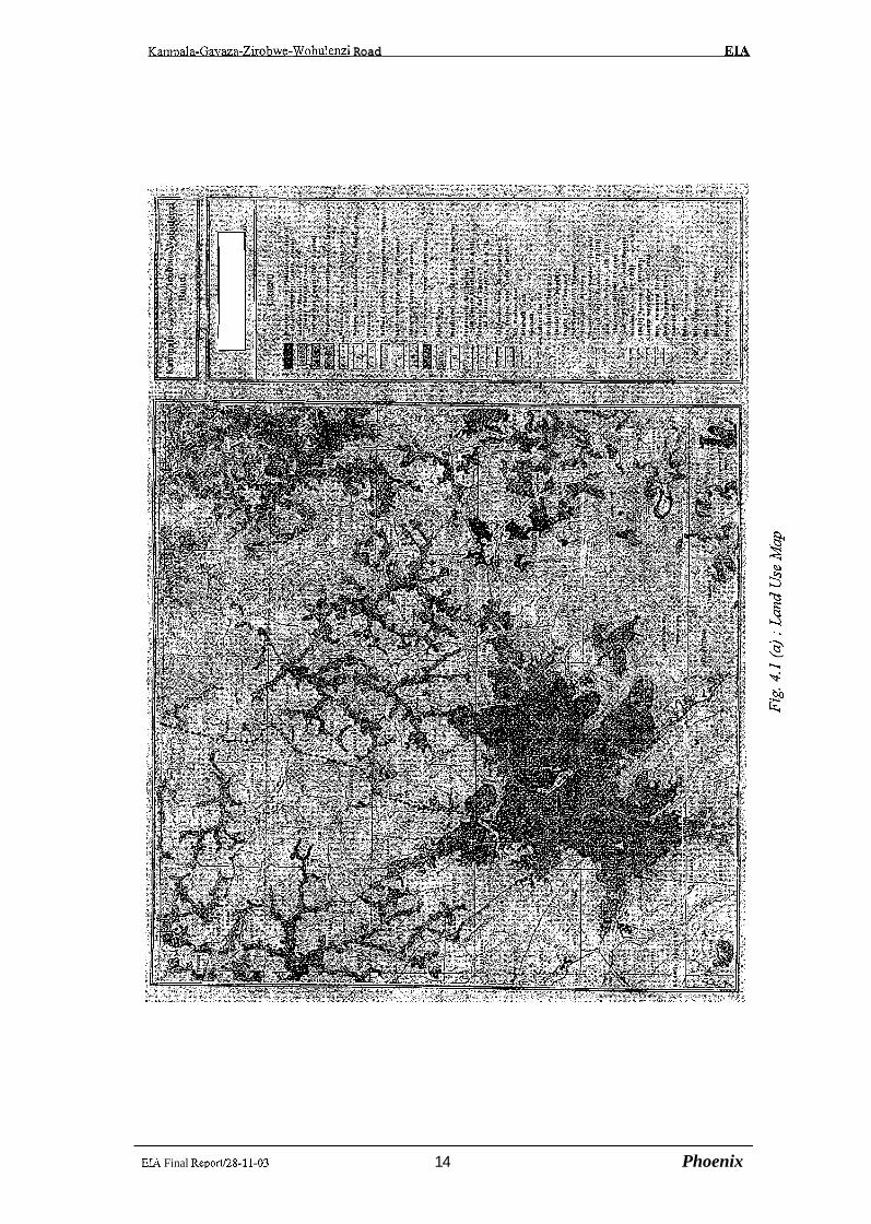
Survey of the ecosystems and human habitats in the Project area, using the following cartographic instruments: - Standard topographic map at scale 1 :50,000 of Kampala and Bombo Regions; - Administrative map at scale 1:50,000 of County and Sub-County, and - Thematic maps on vegetation and land use at scale 1 :50,000.
Documentation on the policy, legal and administrative framework of environmental and resettlement issues.
Collection of statistics on population, land use, land tenure, rural production, and other indicators related to the environmental and socio-economic trends of the project area.
Survey of Road Reserve Area (RRA) and inventory of the constructions and farmlands impacted by road upgrading works and by the enforcement of the rules protecting the road reserve area.
Investigation of the environmental impact of the present road in densely populated areas (air pollution through dust and exhaust emission, safety issues), in ivral areas and in terms of traffic accidents.
Investigation of the expected environmental and social impact of road construction and use, highlighting the positive and negative aspects on short, medium and long term.
Public consultations with local civil leaders, landlords, community development workers, lay people and government official to assess their perception of environmental and resettlement issues, as well as their willingness to participate to environmental protection initiatives.
Informal interviews held on site with field guides who were part of the local community. These focused on their knowledge on their environment and any changes they may have noted in the area over time. Methods of social assessment: A variety of impact assessment methodologies have been utilized in soilrcing the necessary data and these include the Environmental scooping, field observation, focus group discussions with the communities in the project corridor and structured interviews.
EIA Final Report128-11-03 4 Phoenix

Kampala-Gayaza-Zirobwe-Wobulenzi Road EJA
2 PROJECT DESCRIPTION
2.1 The Project Works
The project road is divided into links, which are road sections where there is homogeneity of traffic features such as road environment (urbanlrural), traffic volume, traffic profile (% heavy vehicles) and travel demand (short trip/long trip). In total there are six road sections (links) as described in Table 2.1.
Table 2.1: Class and Type of Existing Road
I S.l Kampala-Nsooba 1 0+000 1 1+300 1.3 1 urban 11 paved I 1 S.2 Nsooba-Mperenve / 1+300 4+600 3.3 urban fringe I1 paved
I S.4 Gayaza-Kiwenda 1 13+500 1 25+200 1 11.7 1 rural I C 1 unpaved I S.3 Mperenve-Gayaza
1 S.5Kiwenda-Zirobwe 1 25+200 44+400 1 19.2 1 rural I C I unpaved I I S.6 ~ i r o b w e - ~ o b u E l 44+400 1 67+400 1 23.0 1 rural 1 C 1 unpaved I
4+600
To achieve the Feasibility Study objective of assessing the viability for strengthening andlor upgrading the existing paved road between Kampala and Gayaza and upgrading to a paved standard the road from Gayaza to Wobulenzi via Zirobwe, two road type options differentiated by cross-section type and road surface structure have been identified for each road section, and three alignment options for the entire route have been assessed. The road type options are summarised in Table 2.2 below and the alignment options are described on the following page.
Table 2.2 : Proposed Road Class and Type
13+500 8.9
S.l Kampala-Nsooba 1 0+000
S.2 Nsooba-Mperenve 1 1+300
I S.5 Kiwenda-Zirobwe 1 25+200 1 44+400 19.2 1 rural III* /IT I unpaved I
S.3 Mperenve-Gayaza
S.4 Gayaza-Kiwenda
1 S.6 Zirobwe-Wobulenzi / 44+400 67+400 1 23.0 1 rural I 111* / I1 1 unpaved I U urban cross-section * widened shoulder
rural
1+300
4+600
EIA Final Report128-11-03
11 1 paved
4+600
13+500
5 Phoenix
1.3
3.3
13+500
25+200
urban
urban fringe
8.9
11.7
U / I *
I* / I
paved
paved
rural
rur a1
11* / I
111* / 11
paved
unpaved

2.1.1 Alignment Option A - Existing Alignment
Early in the Feasibility Study, following completion of the topographic survey, a geometric design was laid over the existing road centreline. This alignment became Alignmc!nt Option A -Existing Alignment.
For this alignment option, in the vertical profile the road level was redesigned to elevate it across swamp areas to accommodate drainage requirements. On the horizontal profile, the alignment closely followed the existing road centreline.
Developed with the intention of having, if compared to other potential options,, the least impact on adjacent land use and the least demand for additional land occupation, this option has many deficiencies at regular intervals along the road length after Gayaza where the existing unpaved road is to be upgraded to a paved road.
From Kampala to Gayaza, the existing road geometry is generally consistent: with the standards set in the MOWHC Road Design Manual. After Gayaza, through to Zirobwe and Wobulenzi, for a road to be upgraded to a paved road with an 80 kph design speed, the existing road alignment has deficiencies, sometimes through the horizontal curves being too tight a radius, but more often through the adverse combination of horizontal curves.
At many locations there are Several consecutive short horizontal curves separated by short straights, or small radii S-bends, or combinations of consecutive S-bends, or kinks in what would otherwise be either a straight road section or a section on a large radius.
Not only is such a design standard inconsistent with the RDM and in particular the section on design form, but the alignment imposes limitations on the occurrence and frequency of forward sight distance necessary for safe overtaking at the higher travel speeds al'forded by the paved road surface. This will affect travel safety.
Consequently, the option for a horizontal alignment which rigidly follows the existing road centreline was abandoned due to these serious deficiencies.
2.1.2 Alignment Option B - Optimised Alignment
This alignment solution follows the existing road corridor and optimises the: separate demands of engineering design standards and social impact limitation.
The horizontal alignment is consistent with the standards specified in the MOWHC Road Design Manual for the appropriate road class design speed, and at trading centres, jn villages and through townships, the horizontal and vertical alignment design is typically d'etemined to reduce cut/fill depths and reduce the degree of shift between the existing and design road centrelines, thereby limiting social impact effects in terms of resettlement and property access.
This is the alignment which is shown on the plans (RP series) and the longitudinal profiIes(PR series) contained in Volume 3 : Drawings, and on the cross-sections cointained in Volume 4 of the Feasibility Study Final Report.
EIA Final Report128-11-03 6 Phoenix

Kampala-Gavaza-Zirobwe-Wobulenzi Road EL4
Whilst the design seeks to limit social impacts, they are not eliminated. These issues are fully explored and plans for the resettlement of affected persons are presented herein in this Environmental Impact Assessment, which is Volume 2 of the Feasibility Study Final Report.
2.1.3 Alignment Option C - Deviations
Over the length of the project road, there are four locations where deviation of the road alignment, away fiom the existing road corridor, would present a shorter route with potential improvement in travel conditions and safety for the through traKic movement. These four deviations are shown on Appendix G of the Feasibility Study Main Report (Volume 1) and a copy of this Appendix has been inserted in this volume following this page. The plans and profiles for each deviation are presented on drawings AA-001a to AA-004d contained in Volume 3 of the Feasibility Study Final Report.
Deviation No 1 - near Gayaza
From km 11+570 at Kasangati on the Mpererwe-Gayaza link to km 14+620,1.2 km north of Gayaza on the Gayaza-Kiwenda link, this deviation is essentially a by-pass of Gayaza. The bypass is about 650 m shorter than the route through Gayaza.
Gayaza is an important district centre and traffic produced by the activities of the centre predominantly travels southwards to Kampala. Although essentially a by-pass of Gayaza, the volume of traffic expected to use the deviation is very low, possibly less than 250 vpd, and the deviation would not obviate the need to strengthen andor upgrade the portion of the Mperenve-Gayaza link from Kasangati through to Gayaza.
Deviation No 2 - north of Busika
From km 3 1+680 to km 32+890, this deviation will eliminate four bends and the road section length will be reduced by approximately 200 m. The deviation crosses an intensive farmed area.
Deviation No 3 -from Vvumba to Kabulanaka, south of Zirobwe
From km 33+510 to km 39+860, this deviation will reduce the actual length of this section of road by about 480 meters. The deviation starts north of Vvumba, bypasses Kakoni and becomes co-incident with the existing road near Ndeeba before bypassing the market area of Bulami village and re-joining the existing road alignment south of Kabulanaka.
Deviation No 4 -West of Zirobwe, from Namawogya through to Bamunanika
From km 48+500 to km 57+270. The deviation (7.3 km long) will reduce the project road length by about 1.5 km. After Namawogya trading centre, the deviation leaves the existing alignment and leading to the north-west enters an area noticeable for the fertility of the soil and the presence of the original vegetation. The deviation generally follows a feeder road serving the Magogo village area and, after crossing the Kayiwagobe river, reaches Kikabya and Kisaku village areas before turning west to join the existing road corridor at Bamunanika.
EIA Final Reporti28-11-03 7 PI20enk
Kampala-Gayaza-Zirobwe-Wobulenzi Road EL4
2.2 Scope of the Study
The Terms of Reference require that "an Environmental Impact Assessment (EIA) and Resettlement Impact Assessment (RIA) will be carried out in accordance with the requirements of EL4 legislation by the Government of Uganda (GOU) and of the Financing Agency as part of the feasibility study".
Any road development has a range of impacts on the environment and community in the area served by the road. These can be considered as positive or negative impacts on the physical or social environment, to be assessed in terms of intensity and duration of impact, and whether they are direct or indirect impacts.
h line with the Terms of Reference, the study has adopted the environmental assessment methodologies advised by the World Bank, to analyze the direct and indirect impacts stemming from:
the road construction process, and: the use of the road after its opening to service.
2.3 Previous Reports
A detailed engineering study and economic evaluation for upgrading1regravell:ing of the Gayaza-Zirobwe-Wobulenzi section of the project road was carried out by Gauff :Ingeniewe in 1993. This study was titled Transport Rehabilitation Project: Upgrading, Regravelling, Rehabilitation of Roads (IDA Credit No P593-UG). Its scope included several roads in the Mpigi and Luwero Districts, one of which was the Gayaza-Zirobwe-Wobulenzi Road.
Available documents from this study are Part 1, Volume I: Engineering Report (Detailed Engineering Study), Oct. 19'93. Part 1, Volume I (Annex): Engineers Cost Estimate, Oct. 1993. Part 1, Volume ITC: Materials Report, Feb. 1993. Part 1, Volume IV: Economic Evaluation, May 1993. Volume LUC: Book of Drawings (A3 size), Feb. 1993. Volume I: Contract Documents, Feb. 1995.
The available documents from the previous study by Gauff Ingenieure in 1993 have been reviewed and the outcomes of such reviews are reported separately in the various technical sections of the Draft Final Report. These earlier documents are reviewed in their historical context and the Feasibility Study reported herein is essentially a stand-alone project.
The Gauff study did not assess the environmental and social impact of the road development.
EIA Final Report128-11-03 8 Phoenix

Kampala-Gayaza-Zirobwe-Wobulenzi Road EL4
3 INSTITUTIONAL AND LEGAL FRAMEWORK OF ENVIRONMENTAL POLICY
3.1 Overview
The National Environment Management Policy for Uganda, stemmed in 1994 from the National Environmental Action Plan (?EM), is to maintain or enhance environmental quality and resource productivity on a long-term basis while promoting sustainable social and economic development. One of the key objectives of the policy is to integrate environmental concerns into all development policies, planning and activities at all levels, and to encourage participation by the people during the development process. With regard to Environmental Impact Assessments (EIA), the policy's objective is to provide a system of EIA and environmental monitoring so that negative impacts arising from a development can be foreseen, eliminated or mitigated. In order to achieve this goal, the policy outlines its strategies as being to:
create a legal EIA process necessitating environmental impact assessments, environmental impact statements and environmental audits for all private and public development projects;
establish a national environmental authority whose function would be to oversee EM, while leaving the actual implementation to the lead agencies involved;
develop EIA capacitylcapability in sectarian ministries-and departments.
Subsequently in May 1995, the National Environment Statute was passed which provided for the establishment of the National Environment Management Authority (NEMA) whose functions are to co-ordinate, monitor and supervise the sustainable management of the environment. The National Environment Action Plan (1995) outlines different roles played by different government ministries and departments in developing environmental awareness. NEAP requires that, each sector ministry has an Environmental Liaison Unit (ELU). NEAP also provides for the creation of District and Local Environment Committees (DECs) and (LECs) at the district and local community levels respectively. Among other responsibilities, these committees are to ensure that; environment related issues are taken into consideration in all developmental projects in their areas.
EIA Final Repod28-11-03 9 Phoenix
~ a m ~ a l a - ~ a ~ a z a - ~ i r o b w e - ~ o b ~ l e & i Road EIA
3.2 Institutional Framework
3.2.1 National Environment Management Authority (NEMA) NEMA is the principal agency in Uganda for the management of the environment and is to co-ordinate, monitor and supervise all activities in the field of the environment.
The functions of the Authority are to: co-ordinate the implementation of Government policy and the decision of the Policy Committee; ensure the integration of environmental concerns in overall national planning through co-ordination with the relevant ministries, departments and agencies of Government; liaise with the private sector, intergovernmental agencies, NGOs and other states on issues relating to the environment; propose environmental policies and strategies to the Policy Committee, initiate legislative proposals, standards and guidelines on environment in compliance with the Statute review and approve environmental impact assessment and environmenltal impact statements submitted in accordance with this Statute or any other law; promote public awareness through formal and informal education about environmental issues; undertake such studies and submit such reports and recommendations with respect to the environment as the Government or the Policy Committee may consider necessary; ensure observance of proper safeguards in the planning and execution of all development projects, including those already in existence that have or ar~s likely to have significant impact on the environment determined in accordance with Part V of this Statute; undertake research, and disseminate information about the environment; prepare and disseminate a state of the environment report once in every two :years; mobilise, expedite and monitor resources for environmental management; and perform such other functions as the Government may assign to the Authority or as are conductive to the exercise by the Authority of any or all of the functions provide for under this Statute.
This project development therefore, has to be undertaken bearing in mind, the environmental law detailed in the National Environment Statute of 1995
3.2.2 Environmental Liaison Unit (ELU). The MOWHC already has such a unit. It is hoped, that the ELU will play an important role in environmental monitoring and management in the road sector rather than simply,, liaison.
3.2.3 The Uganda Land Commission This, agency is responsible for registration of land titles and is operating under the District Land Boards, Water and Environment. The operations of the Commission are governed by the Land Act of 1998. The Commission has District Land Boards, District Land Tribunals and Parish Land Committees to assist its operations in the field.
EIA Final Reportl28-11-03 10 Phoenix

Karmala-Gayaza-Zirobwe-Wobulenzi Road EIA
3.2.4 Non Government Organisations (NGO) A number of NGO1s assist in the development of the social environment. The include the National Council For Children and the Child Welfare NGO, Women advocacy NGOs e.g. FDA, Action For Development (ACFODE), FEMBUTE and National Association of Women of Uganda (NAWOU) etc.
3.3 Environmental and Social Assessment Regulations
3.3.1 Environmental regulations. The EIA Regulations of 1998 make it mandatoty for all projects listed in the Third Schedule of the Statute and any major repairs, extensions or routine maintenance of any existing project included in the Third Schedule of the Statute to conduct EIA in accordance with the regulations before implementation. These regulations are therefore applicable to all major road development projects (such as KarnpaIa-Gayaza-Bugema-Zirobwe-Wobulenzi road) and all roads in "scenic, wooded or mountainous areas". In line with these requirements, Section 97@) of the Environment Statute, stipulates that "Any person who fails to prepare an EIA contrary to the Third Schedule commits an offence and is liable, on conviction, to imprisonment for a term not exceeding 18 months or a fine of not less than 180 thousand USh and not more than 18 million USh or both". These legal instruments and obligations are geared towards ensuring that, environment and natural resources at large zire protected to ensure sustainability and social well being of Ugandans.
3.3.2 Social Laws and Regulations. 1. The Employment Decree of 1975 which prohibits employment of persons below the
age of 18 unless authorised by the Commissioner of Labour. ii The law of equal opportunity of employment for men and women. iii The Land Act (1998) which makes provision for land ownership titles and
compensation for and required by projects.
EL4 Final Repod28-11-03 11 Phoenix

4 ENVIRONMENTAL SETTING: BASELINE CONDITIONS
4.1 Location
The existing road (67 km) lies in the districts of Kampala, and Luwero and is part of the road system connecting the Central Region with the Kampala urban area (refer Figure 1, page 2). The road serves an area between two major trunk roads: to the west the paved road Gulu-Luwero-Kampala that serves the north of the country and at east the Kampala- Mukono-Bukoloto road that channels the traffic going to Kampala and coming fiom north of Mukono and Kamuli districts. In fact the project road stretches for all its length, almost in the middle of these two roads and collects the traffic coming fiom and going to the north as far as Wabusana and Kakukulu in Luwero District, and Kazwama in the recently established Nakasongola District.
4.2 The Biophysical Environment
4.2.1 Topography. The project area is part of the Central Plateau Ecological Region, which has intermediate altitudes (1,100-1,300 meters a.s.1.). The area is characterised by flat-topped hills that rise to an average height of about 1250m.a.s.l. and they are separated by broad, uniform valley slopes which descend into extensive papyrus wetlands draining north-east to river Lwajali and lake Kyoga and west to river Kah. The area hosts a variety of ecosystems, ranging from permanent to seasonal wetland, forestlsavanna mosaic of mixed tree, thicket, shrub and grassland including post cultivation vegetation types. All ecosystems are heavily modified by human action, including deforestation, overgrazing, nature depleting farm practices and excessive urbanization.
4.2.2 Climate. Although the project area lies within the equatorial belt, the would-be tropical climate of this area is considerably modified by its elevation above sea level and its vicinity. to lake Victoria. The mean diurnal maximum temperatures range between 18" and 35" while the corresponding minimum diurnal range is 8" and 25". Temperatures peaks are in fhe months of January to March and October to December. Cloudiness and rainfall affects temperatures slightly. For most of the year the area records less than 55% sunshine. This Ieads to a reduction in the net radiation recorded on the ground and hence low surface air temperature. Rainfall patterns are bi-modal. There are two wet seasons running fiom April to1 May and September to November. The principal rainfall peak is in April while the minor. one is in November. The dry months are January-February and June-August and are frequently broken by thunderstorms. The annual rainfall mean is between 1125 and 1350 mm and the average monthly days of rainfall are 10. Relative humidity is high in the project area due to its equatorial position, high rainfall and its proximity to lake Victoria. It is highest in the early hours of the day (85% at 0600 GMT) but decreases rapidly during the aftern.oon (61% at 1200 GMT). The winds of the area are however modified by the increased rough surface
In February 2001, the Mpigi district has been split into two separate administrative units: Mpigi district (Western part) and Wakiso district (Eastern part). The project road actually lies in the new established Wakiso district. Since statistical data are not available, at present, for Wakiso district, this report still refer to the former Mpigi district.
EIA Final Report.128-11-03 12 Phoenix

due to the numerous flat topped hills and tree vegetation. The average annual wind speed is 7.8 hots . Anyhow the area experiences localized strong winds in form of eddies during the dry season and the rainstorms accompanied by strong breezes and moderate gals that often lead to breaking of tree branches.
4.2.3 Geology and Soils. Most of Central Uganda, including the project area, is represented under the Buganda-Toro
System. Argillites predominate, but basal or near basal arenites are an important feature. Locally, as west of Kampala, occur tick anphibolites which are probably derived from basaltic material. Large tracts of the system are granitized; on the other band low grade phyllites also occur. While in general the system appears to lie upon a gneissose basement, this basement has been mobilised and it is, in some places, difficult to distinguish from granitized Buganda-Toro System rocks. Folding is fairly tight on predominantly east-north- easterly axes in the east but varies in the west. Axial planes are steep and there is a tendency for this folding to decrease in intensity with lowering of metamorphic grade southwards. Age determination suggest a metamorphic age of approximate 1,800 million years. Provisionally included within the Buganda-Toro system are the Igara Shists composed mainly of quarzites mica schists and gneisses, the Buamba Pass Series of Ruwenzori which is made up of grits, sand stone, slates and phyllites and the Kilembe Series of Toro. Soil conditions are very uniform in spite of the hilly topography. Hill summits and upper slopes consist of shallow, skeletal soils developed from quartzite or iron stone (ferralitic soils). Deep red clays occur on the pediments and are the main crop soils. Soils on the slopes merge into grey, swamp edge soils and finally, into the true swamp soils. Fertility of the soils drop with cropping intensity or if less productive soils of the system are used in response to land pressure. However, natural fertility is high in areas where the soils are protected against erosion and crops are rotated.
4.2.4 Water Based on previous environmental studies, the water quality indicators of river Lwajali, the main collector of waters from the project area, can be summarized as follows: the water tends to vary from neutral to basic conditions (pH = 7.821). This also means little dissolved oxygen in the water probably due to a lot of organic matter that tends to raise the Biochemical Oxygen Demand (BOD) of the micro-organisms involved in the decay processes. The Electrical Conductivity (87,6) is indicative of fresh water free from industrial pollutants that tend to give water acidic properties and high EC, which is contrary to the observed. The organic matter is therefore originating from the wetland, which has its own natural processes of pollution control without causing a danger to the environment.
4.2.5 Air Quality The existing road environment is extremely dusty in dry weather due to vehicles travelling at high speeds along the road. Roadside plants and crops are covered with a thick layer of dust. Local residents are constantly exposed to a high level of dust from the road, particularly in dry conditions when mini-buses and trucks pass at high speed.
EL4 Final Report128-11-03 13 Phaenisc
Kampala-Gayaza-Zirobwe-Wobulenzi Road EIA
EIA Final Report128-11-03 14 Phoenix

Kampala-Gavaza-Zirobwe-Wobulenzi Road EM
EIA Final Report128-11-03 15 Phoenix

Kampala-Gavaza-Zirobwe-Wobulenzi Road EIA
4.2.6 Vegetation. The vegetation of the project area (Figures 5.1.1 and 5.1.2) follows the existing ralinfall and relief pattern. It is a relic of the original vegetation where there are remnants of co~nrnunities related to the savanna woodland cliniaK -and the Combretum/Cymbopogon afronardus fire climax tree savanna, particularly on the hills. This area is believed to have been covered by forests prior to the introduction of agriculture. The vegetation of the project area comes within the study carried out by the National Biomass Study team of the Uganda Forest Department. The study divides the vegetation into six major classes as follows:
Subsistence Mixed Farmlands This comprises of land recently or currently under use with or without trees and aigricultural fallow areas. It ranks first in size and covers about 80% of the project area. The plants found in these farmlands are food crops, which include cassava and maize. Almost the totality of homesteads have small plots with coffee shrubs and banana plantains (matoke). ]Fruit trees such as the mango and Jacldruit and other multipurpose trees integrated in the farming systems are found in the vicinity of homesteads. In some of the farmlands, an abundance of eucalyptus spp, Markhania platycalyx and Musa spp (bananas) are found. The dominant weeds in this sub-division include: Digitaria scalprum, Oxalis latifolia, C'ommelina bingalensis, Imperata cylindrica, Cynodon dactylon and Euphorbia prostuata.
Vegetation in Built-up Areas This covers a large part of the project area. It includes urban areas, villages, compounds, school recreational grounds etc. along the road. Around homesteads are trees that have been planted for both shade and ornamental purposes. The most common species are: cassia agnes, markhamia platycalyx and Jacaranda mimosifolia. Other plant species include Bougainvillaea spp, Acalypha spp and grasses such as Brachiaria spp, Hypawhenia spp, etc.
Woodland Trees and Shrubs This vegetation represents most wooded areas where trees and shrubs are the predominant cover. These are mostly of an average height of 4m. It is found mainly in parts of project area in Luwero district. Wet woodland communities occur along wetlands and the dry woodlands appear on the dry grass covered areas. Deciduous trees are also commo~i.
Bush, Thickets and Scrubs This kind of vegetation is found in most part of project area with an average height of less than 4m. The bushes, scrubs and thickets grow together as an entity. This vegetation also occurs on abandoned farmland in form of late fallow with rapid re-growth of mainly Lantana camara.
Wetland Vegetation The project area has several permanent and seasonal wetlands covering about 5% of the area The major wetlands are associated with Lake Kyoga drainage systems. Many wetlands around Kampala district have been drained and turned into agricultural areas or developed for commercial, industrial and sometimes residential purposes. The unclaimed wetlands along the project road are covered by both grasses and sedges. The most common species are papyrus, Miscanthidium violeceum, Phragmites maurtianus, Cyperus lato5lius and Typha australis. Indicator tree species associated with this vegetation include Acacia sieberana and palms.
Post cultivation communities These arise as a result of intensive farming on the soil and thereafter abandonment due to loss of fertility. They are associated with poor and heavily leached soils and are a stage in the sequence from agricultural crops to the climax vegetation associated with particiular area. The majority of post cultivation communities are short-lived and contain many of tlle species
Elk Final Report/28-11-03 16 Phoenk

Kampala-Gavaza-Zirobwe-Wobulenzi Road EIA
found in the grass layers of their more stable successors. In places of high population density, overexploitation of the land without remedial measures has resulted into soil fertility degradation. Hillsides have bee opened for cultivation and left bear at times thus accelerating the threat of soil erosion. Loss of soil fertility is observed in most parts of the road influence area (mainly in Kyarnbogo and Nangabo sub-counties) and many areas are also experiencing serious soil erosion problems and gullies formations are evident. Overgrazing is more evident in Zirobwe and Bumunanika sub-counties.
4.2.7 Fauna At the moment, the actual faunal situation in Kampala, Mpigi and Luwero districts is not known. However, the proposed upgrading road works are within the present road and settled area. This means human activities such as deforestation, cultivation, draining of swamps and urbanization have affected the existence of wildlife along the present road and endangered wildlife has disappeared since decades from the project area. The faunal groups were documented and part of the information was fiom local communities. No wild mammals were encountered in the project area except for local communities reports on the occurrence of the Common Rats, Giant Otter Shrew and Vervet and Red tailed monkeys. Opportunistic documentation of avifauna group was made during the survey. Birds recorded included: Ring-necked Dove, Weaver bird, Harnmerkop, Common Bulbul, Black Flycatcher and Guineafowl. Fish species such as, protopterus aethiopicus (mud fish), clarius gariepinus and bagrus paludinus were among those reportedly caught by the local communities in seasonal wetlands around. Fishing is not significant in the project area since there is little open water.
4.3 The Human Environment
4.3.1 Population. The population of Kampala, ~ ~ i ~ i ~ and Luwero districts, the administrative units where the project area lies, was 2.6 million people in June 2000, according to the mid-year population projections estimated by the Uganda Bureau of Statistics (see Annex I), based on the projection of the official series shown below (Table 4.1). The inter-census growth rate of the three districts interested by the project area increased from 2.5% in 1969-80 to 2.6% in 1980- 91, contrary to the national demographic trend that reflects a slow-down (from 2.7% to 2.5%).
Table 4.1: OfJicial data on the population of Kampala, Mpigi and Luwero Districts (1 969-96)
I Luwero 1 268,000 1 338,500 1 349,200 1 512,700 1 2.2 1 0.3 1 1.2 1
Kampala
Sources: a) Population Census: 1969,1980 and 1991 and official administrative figures for 2000
During the period 1980-91 the district of Luwero experienced a remarkable slow-down, which is attributable to out-migration due to the civil war. Kampala's population is expected
330,700
See footnote at page 12
EIA Final Report128-11-03 17 Phoenix
458,500 1 774,200 902,900 1 3.1 1 4.8 1 4.0
-ma-Zirobwe-Wobulenzi Road EIA
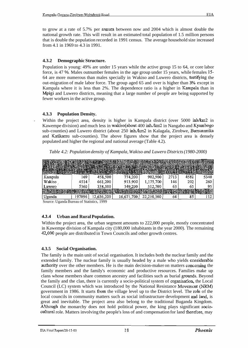
to grow at a rate of 5.7% per annum between now and 2004 which is almost double the national growth rate. This will result in an estimated total population of 1.5 million persons that is double the population recorded in 1991 census. The average household size increased from 4.1 in 1969 to 4.3 in 1991.
4.3.2 Demographic Structure. Population is young: 49% are under 15 years while the active group 15 to 64, or core labor force, is 47 %. Males outnumber females in the age group under 15 years, while females 15- 64 are more numerous than males specially in Wakiso and Luwero districts, testifying the out-migration of male labor force. The group aged 65 and over is higher than 3% except in Kampala where it is less than 2%. The dependence ratio is a higher in Kampa~la than in Mpigi and Luwero districts, meaning that a large number of people are being supported by fewer workers in the active group.
4.3.3 Population Density. Within the project area, density is higher in Kampala district (over 5000 inh/km2 in - Kawempe division) and much less in wakiso(about 400 inh./lan2 in Nangabo and ICyambogo sub-counties) and Luwero district (about 250 i n h . h 2 in Kalagala, Zirobwe, Bumunanika and Katikamu sub-counties). The above figures show that the project area is densely populated and higher the regional and national average (Table 4.2).
Table 4.2: Population density of Kampala, Wakiso and Luwero Districts (1980-2000)
Source: Uganda Bureau of Statistics, 1999
4.3.4 Urban and Rural Population. Within the project area, the urban segment amounts to 222,000 people, mostly concentrated in Kawempe division of Kampala city (1 80,000 inhabitants in the year 2000). The remaining 42,000 people are distributed in Town Councils and other growth centres.
4.3.5 Social Organisation. The family is the main unit of social organisation. It includes both the nuclear family and the extended family. The nuclear family is usually headed by a male who yields colnsiderable authority over the other members. He is the main decision-maker on matters conc;erning the family members and the family's economic and productive resources. Families make up clans whose members share common ancestry and facilities such as burial groundls. Beyond the family and the clan, there is currently a socio-political system of organisation: the Local Council (LC) system which was introduced by the National Resistance Movement 0 government in 1986. It starts fiom the village level up to the District level. The irole of the local councils in community matters such as social infrastructure development and larid, is great and inevitable. The project area also belong to the traditional Buganda Kingdom. Although the monarchy does not hold political power, the king plays significant socio- cuItural role. Matters involving the people's loss of and compensation for land therefore, may
EIA Final Repod28-11-03
call the attention of the relevant ministry in the Kingdom government. The nuclear family, the extended family and to some extent, the clans constitute significant traditional social support system for their members especially in times of difficulty.
4.3.6 Ethnic Groups The 1991 census singled out 34 ethnic groups present in Kampala, Mpigi and Luwero districts. In terms of numerical strength, the most important ethnic group in the project area are the Buganda, belonging to the Bantu linguistic group. They comprise almost the 85% of the population that occupies the central and the southern part of the country, from lake Victoria to lake Kyoga in Central Uganda, better defined as Buganda region. The Buganda are homogeneous both linguistically and culturally. They are hard working people who have taken full advantage of their favourable geographical and economic position. Many other ethnic groups have however settled in Buganda region (Banyankore, Basoga and Bakiga of the Bantu area, the Nilo Hamitic Iteso coming from East, the Nilotic Langi and Acholi people coming from northern Uganda).
4.3.7 Land Tenure. Land Tenure systems in Uganda are a mix of traditional practice, colonial regulations, and post colonial legislations. Land holdings differ across the project area and currently fall under the following categories: Private mailo, Freehold, Leases holdings and Customary holdings (Bibanja).
Mailo Tenure This was introduced in Buganda following the Buganda Agreement of 1900. Originally, it was of two categories, notably private and official mailo. Subsequently in 1967 official mailo was transformed into public land. A principal feature of the mailo system was that of modified freehold. Mailo estates were surveyed and the holders given certificates of title which could easily be transferred. Consequently, many sub-divisions of the original mailo holdings have taken place. These title deeds have also been used as collateral security in financial institutions and have thus contributed to development. About 70 % of the land is held under the mailo system. It has been argued that this kind of tenure hinders developments in the agricultural sector. Land is an asset that has to be protected. However, mailo tenure is such that ownership and tenancy are not the same in many cases. Therefore, tenants on such land have tended to neglect looking after and investing in land because of lack of security of tenure. Also, occupants have neither been allowed to plant trees on such land nor reap benefits without permission from the landlords.
Freehold Tenure In the project area, there are very few freehold tenures. These are mainly held by religious bodies such as the church of Uganda, the catholic church.
Leasehold Estate A leasehold estate is an estate created in land as a result of an agreement between a leaser and a lessee. The lessee thereafter enjoys exclusive usage and possession of the land of the leasor for a specified period of time. This is in consideration of a cash payment called rent moving fiom the lessee to the leasor. The majority of leasehold titles over public land in the district are granted by the Uganda Land Commission while those over urban areas by the urban authorities. Urban authorities hold such land on statutory leases from Uganda Land Commission. In urban areas leases are granted for 99 years after completion of development while in the rural areas the period granted is usually 45 years. However, leaseholds are not very common in the rural areas. This may be partly due to the lengthy bureaucratic process that has to be folIowed before lease application can be considered by Uganda Land
EIA Final Reportl28-11-03 19 Pktoenrjc

Kampala-Gavaza-Zirobwe-Wobulenzi Road EIA
Commission. The other hindrance is usually the huge task of compensating and resettling people who may be settled on such land. Leasehold tenure, therefore, is more c~omrnon in the urban areas than the rural ones.
Customary Tenure This is the oldest system of tenure in the project area. It is also the most wide-spread. Most people occupy land under this system. In the past, there used to be four categories of rights of control. They included: Right of clans over land (obutaka), Rights of the Kabaka and lor chiefs (obutongole), Individual hereditary rights (obwesengeze), Peasant rights of occupation.
Overtime this tenure has been overtaken by historical events and at the moment it is a tenancy on mailo land.
Various attempts have been made to address developmental concerns arising from these various systems with a view to stimulating development and preserving the environment. Article 26 of the 1995 Constitution of the republic of Uganda empowers individuals to own property and also protects them from compulsory deprivation of such property. The article further states that if such property (in this case land) is required for public use or interest, the affected individual be adequately compensated. Clause 4 and 5 of article 237 further provide that customary and leasehold tenure systems can be converted to freehold by registration and in accordance with a law to be made by Parliament re,spectively. Statutory leases by urban authorities are also affected. In essence, the 1995 constitution seeks to give more powers to the people in so far as ownership is concerned.
Land holding in Kampala district currently falls under the following categories: private mailo, statutory leases held by the Kampala City Council, land under direct control of Uganda Land Commission, freehold and leases held by institutions.
More than 90% of land holdings in Kawempe division is private mailo. In Mpigi a~nd Luwero districts the most wide-spread landholding is the customary tenure and the majority of people occupy land under this system. At the household level, land is traditionally owned and controlled by the male head of the household. A discussion with a women group however, indicated that some independent women do buy land and own land while others !inherit and control it. Value of land in the area ranges between USh- 700,000 and USh. 900,000 per acre. The value is relatively higher in Kiadondo county than in Bumunanika county. In Kampala urban district the value of land passes 1 million Acrelacre.
4.3.8 Economic Activities and Standards of Living. Agriculture employs 84 % of the manpower in Mpigi and Luwero districts, and ac;counts for 65% of the districts gross domestic product. In Kampala district, agriculture is an activity of relatively less significance and the main sources of livelihood are employment and trading (80% of manpower). Industrial sector in Kampala district is still dominated by small-scale industries. Informal industrial activities are common throughout the project area in Kawempe division, on residential plots, unofficial markets and roadsides. Small s.cale semi- formal activity is found in and around official markets and in formally licensed. premises. Industrial establishments on Mpigi and Luwero districts are confined to small-scale, agro- based mainly seasonal coffee processing. Trading is diffused but insufficiently organized in terms of wholesale facilities and distribution infrastructure. Albeit far from being developed
EL4 Final Reportf28-11-03 20 Phoenix

Kampala-Gavaza-Zirobwe-Wobulenzi Road EIA
in terms of monetary incomes, the economy of the region, however, is not affected by acute poverty. The food balance is almost in equilibrium, thanks to subsistence-oriented farming and the wealth of livestock resources. Children, in general, do not appear to suffer fi-om malnutrition or widespread diseases.
4.3.9 Agriculture. The Field observations and interviews identified subsistence farming as the main economic activity in the project area. Coffee was identified as the main cash crop. In fact, despite its large contribution to the economy, agriculture largely remains of the subsistence type. Farmers produce mainly to feed their families, though cash crop fanning is well developed. Farming in the project area can be categorized in intensive banana-coffee lake shore farming system. This system covers Kampala, north of Wakiso and south of Luwero districts. Much of the farming is based on the growing bananas and coffee. In addition to these two perennial crops, a number of annual crops are grown. They include maiz, cassava, sweet potatoes, beans etc. Vegetable and fruits are also grown (tomatoes, cabbages, pineapples, mangos, passion fruits). The bananas and coffee are grown around the homesteads and sometimes they are inter-cropped. the presence of perennial crops along the project road has beneficial effects on soil conservation by providing cover throughout the year. Table 4.3 shows the most recent statistics about agricultural output in Wakiso and Luwero districts.
Staple food crops - bananas (matoke), sweet potatoes, cassava, beans - represent almost 92% of the area's agricultural output, against just 8% for cash crops like coffee, even though bananas are largely produce for household consumption as well as for the market. The vicinity of Kampala district offers a ready market for all farm products, There is high demand of agricultural products because of the high human population to the extent that what is produced in the district is just a small fraction of what is consumed.
Table 4.3 : Agricultural production of Wakiso and Luwero districts
1 Maize 27.000
Cassava 83.000 Bananas 267.000
31.000 Coffee 41.000 Source: Statistical yearbook, 1999
Sorghum Sweet potatoes
4.3.10 Animal Resources.
3.000 65.000
Since no rangeland lies in the project area, herding is non existent along the project road. In Kampala district the number of cattle has shrunk due the crack down by the city authorities on free range cattle keeping. Small herd of cattle (maximum 20 heads) is possible to meet along the project road in Zirobwe and Bamunanika sub-counties, but the most common system to raise cattle in the project area is the one called zero grazing. The cattle numbers kept under this system range mainly within 1-3 animals and mainly milking ones. The animals are fed on crop residues, planted grass and commerciaIly prepared feeds. Ranches are present in Bumunanika sub-county (six ranches) and mainly raise beef animals, sold to Kampala abattoirs. Goats, sheep, pigs and chicken are few, save a big poultry farm located in Magigye along the project road.
EIA Final ReportI28-11-03 2 1 Phoenix

Kampala-Gavaza-Zirobwe-Wobulenzi Road EI A
4.4 Cultural Heritage in the Project Area
There is one officially classified historic site of interest within the study area: The Buganda King's palace in Bumunanika (500 meter from the project road). At present, this site does not rank as a major tourist attraction, but could yet be another site for tourism, not far from Kampala and not far off the road to Murchison Falls National Park.
Photo 4.1: The Buganda King's Palace at Bamunanika. This site can be a cultural and tourist attraction not farfiom Kampala.
4.5 Administrative Arrangement
The project road lies in Kampala, ~ ~ i ~ i ~ and Luwero Districts and directly influences the administrative units shown in Table 4.4 on the following page
Each district is ruled by its own Council, which is also responsible for environmental and resettlement measures. The districts are administratively subdivided into counties, sub- counties and parishes. Kampala district is subdivided into divisions.
See footnote at page 12
EIA Final Repo1V28-11-03

Table 4.4: Administrative units influenced by the project road
1 Kampala urban I Kawempe (division)
Mpigi
Busukuma Guluddene 2,700 2,900 Kyambogo Kikoko Kiwenda 1 2,200 4,800 1 Kyadondo I Magigye ( 3,500
1 Bularnu Gayaza 1 5,200 6,900
Source: Uganda Bureau of Statistics. Projected mid-year population 1995-2015
4.6 Public Services
4.6.1 Fuel Supply. According to field investigations, most households in the project area use fnewood or charcoal for cooking, and parafin or electricity for lighting. Electricity is available along the project road fiom Kampala up to Busika and from Zirobwe to Bamunanika and Wobulenzi. Leaving Kampala, eleven petrol stations have been counted along the project road, mainly located (7 stations) on the paved stretch; the remaining four are located in Namulonge. Busika, Zirobwe and Bamunanika respectively.
4.6.2 Water Supply. Field observations and interviews revealed that the main source of water is the open well or spring. Others are, stream or river, protected well or springs, and boreholes. Piped water, during the survey, was available only in some areas of Kawempe in Kampala urban.
4.6.3 Public Health. Out of Kampala urban4, a total of 8 health facilities with 44 beds are located within the road influence zone, 5 dispensaries and 3 health centres, 7 of them located just beside the project road (three health centres: Kazinga, Zirobwe and Bamunanika; 4 dispensaries: Kasangati, Namulonge, Bugema and Vvumba).
Mulago hospital, the main hospital in Kampala, is located just a few hundred meters f?om Kalerwe round-about, the project road zero point.
EIA Final Repod28-11-03 23 PhoenIjc
According to the 1997 Health Services Inventory, geographical access to health facilities in Mpigi and Luwero districts is limited to only 49% of the household, and only 42.7% of the parishes, the smallest administrative unit, have some form of health facilities. While it is believed that Government health units provide fiee medical services, the practice is that patients bring their own bedding and pay for most essential drugs. Malaria, the leading cause of death in the districts is most prevalent in the brick making areas and near wetlands because mosquitoes breed in water that collects in the clay pits, and in stagnant water in the wetlands. Personnel of health facilities along the Gayaza-Zirobwe-Wobulenzi road also talk of cases of respiratory complications and suspected allergies due to dust from the road especjally in the dry season.
4.6.4 HWAIDS Control. Under the supervision and the coordination of the Uganda AIDS Commission, governmental institutions and over 1000 NGOs, religious groups and individuals, are involved in the prevention, provision of care and support to people infected and affected with HIVIAIDS. One of the more actives in the project area, with operational units located at Wobulenzi and Bamunanika, is Plan International. There is a reported general decline in the HIV prevalence fiom about 30% in 1993 to about 10% by 1996. According to the 2000 HIVIAIDS Surveillance Report, data fiom HIV infection sentinel surveillance sites in Kampala, Mpigi and Luwero districts, continue to show declining trends in urban areas. In rural areas where trends in the past exhibited a mixed pattern of stabilization and decline, prevalence rates appear to be clearly declining (from 27.1%. in1993 to 12.3% in 1999). In spite of the observed dent in the HIVIAIDS epidemic, the infection rates are still high in the whole Country. As for the year 1999, a cumulative total of 55.861 AIDS cases has been reported to surveillance unit of the AIDS Control Programme and at present the total number of people living with HIVIAIDS is estimated at 1.44 million. It is believed that every households in the project area has in some way been affected by the epidemic.
4.6.5 Schools. According to field surveys, more than 5000 pupils attend to 30 primary and secondary schools located on either sides of the project road. The road serves also thr: Bugema University Campus and High School located in the homonymous village. However, some 18 schools are recorded within 1 kilometers off the road.
4.6.6 Lack of Ancillary Road Facilities The present road is not endowed with ancillary infrastructure suitable to sustain the expected traffic increase and its impact on the economy.
Major shortcomings bear upon: 1. . . traffic police facilities outside Kampala urban area 11. axle load control services iii, motor parks and land transport stations iv. organised parking areas for trucks at major stopovers v. workshop areas for vehicle repair vi. communication services for transport-related and safety management needs
Traffic police posts presently exist along the gravel road, at Narnulonge, Bugema, Zirobwe and Bamunanika. The environmental specialist has surveyed the existing motalr park of
EIA Final Report.128-11-03 24 Ph0enk

Zirobwe, which consists of a dirt space of some 1000 m2 without fencing and is devoid of essential facilities as a shade for travelers. If the road is upgraded, it will be necessary to upgrade Zirobwe motor park and develop another one in Barnunanika.
Photos 4.2 and 4.3: Zirobwe- Wobulenzi Road Section. School playground on the road side, and ...
... an "up-and-coming" using the road berm as a playground. Road safety management and proper school courses on road safety and safe behaviour when near the road will reduce the risk ofroad accidents.
-
EIA Final Report128-11-03

4.7 The Existing Kampala-Gayaza-Zirobwe-Wobulenzi Road
The Kampala-Gayaza-Zirobwe-Wobulenzi road (67 km) is part of the dense: network connecting north Kampala with Mpigi, Luwero, Mukono and Nakasongola districts. The project road-(Figure 1 .I, page 3; and Figures 4.2, 4.3, 4.4 and 4.5 on the following pages) consist of 14 km asphalt road, starting at Kalenve roundabout (0 km) and stretching north between Kampala and Gayaza (13 km paved road), followed by 53 km gravel road leading north-east to Zirobwe before turning west to join the main road Kampala-Luwero-Gulu at Wobulenzi town. The first section (asphalt) holds the intense urban traffic of Kampala North, while' the gravel road serves a densely popuIated agricultural area and canalizes the commercial traff~c coming from the rural network intersected. Major rural centers along the project road are: Kasangati (1 1 km), Gayaza (14 km), Namulonge (22 km) in Mpigi district and Zirobwe (44 km) and Bamunanika (57 km) in Luwero district. It is proposed to resurface the existing asphalt road fiom Kampala to Gayaza, while the Gayaza-Bugema-Zirobwe- Wobulenzi gravel road will be upgraded to a 5.6 meters wide class 111 asphalt roa~d with 1.5 meters shoulders on either side.
Altogether, the landscapes traversed by the road have been profoundly altered by the action of man, especially though excessive pressure on farming.
For environmental purposes the road can be divided in two sections:
Kampala-Gayaza. A section of paved road (14 km) fhther sub-divided in urlban, semi- urban and rural road. The urban (1.6 km) and semi-urban (3.1 km) section ('7-8 meters wide) commences at KampaIaKalenve round-about and ends at Mpererwle junction (4.7 km) The rural section (6 meters wide) leaves Mperenve Jctn and reachles Gayaza township (14 km). The terrain is mostly hilly, with downward slopes to the road axis. The road lies in a densely populated area that shows environmental decay due to the human encroachment. Built up areas and farmland intermingled with residual bush Iand and thicket formations stretch on both sides of the road. Commercial and artisan activities are widespread along the road keeping the area permanently busy.
Gayaza-Zirobwe-Wobulenzi. A section (53 km) of gravel road, 6 to 4 meters wide, that fiom Gayaza takes a north-easterly direction and continues this way up to Zirobwe trading centre. From Zirobwe the road takes a distinct westerly direction and approaches Wobulenzi township, on the main Kampala-Gulu road, after passing the Bamunanika trading centre. The terrain is generally hilly. The landscapes are similar to those of paved rural section, but with a lower human pressure on the environment. The road traverses a vast agricultural area; household scale banana and coffee plantations are predominant, there are residual forest groves and wetlands. Presence of small herds of cattle moving along the road and existence of mango tree plantations are met especially on Zirobwe-Wobulenzi section.
Most of the road was stilI in reasonable condition during the field reconnaissance carried out in September 2000. However, the surface of the gravel road is rough and creates a large mount of dust when traffic passes. Interviewed road users have reported that during heavy rain storms, traffic becomes difficult and dangerous for all vehicles, especially along the link between Gayaza and Zirobwe.
EIA Final Repod28-11-03 26 Phoenix
Kampala-Gavaza-Zirobwe-Wobulenzi Road EL4
EIA Final Repod28-11-03 27 Phoenix
Kampala-Gavaza-Zirobwe-Wobulenzi Road EM
EL4 Final Reportl28-11-03 2 8 Pkt0enk
Kampala-Gavaza-Zirobwe-Wobulenzi Road E M
EI.4 Final ReportI28-I 1-03 29 Phoen k
Kampala-Gavaza-Zirobwe-Wobulenzi Road EL4
EIP, Final Report128-11-03 3 0 Phoenix
Kmala-Gayaza-Zirobwe-Wobulenzi Road EL1
4.8 Settlement Pattern Along the Road
The first section of the road (14 km paved) traverses the high densely populated and commercially busy area of Kampala north in Kawempe division. From Km 0 (Kalenve round-about) to Km 4.7 (Mpererwe junction) the roadside is exclusively occupied with an intense commercial activity carried out in market areas (Kalenve mkt), permanent shops, temporary stalls and tables and with a continuous presence (day and night) of thousand of pedestrians, bicycles and motor-vehicles. From Mperenve junction to Gayaza Township, commercial activity along the road is less intense, but still consistent during day hours due to the presence of many shops and industrial complexes. A physical count of residential houses along the first section of the road yielded an average of about 120 houses on every Kilometers of the road, either side, ranging between 85 and 270 houses per Kilometers. From Gayaza up to Zirobwe and Wobulenzi, the entire stretch of the road is relatively densely populated and the houses are concentrated in or around trading centres. Housing density of this section (gravel road) is about 24 houses/Kilometer of road. Some areas are relatively unpopulated, but few stretches of the roadside are without any house. The case is more prevalent for the stretch in Zirobwe, Bumunanika and Katikamu sub-counties.
Vegetal landscapes and land use along the road. As shown in Table 4.5 and Figures 5.1 (a) and 5.1 (b) on pages 15 and 16, about 60 km out of the 67 krn length of the project road are lined by more or less densely farmed fields or fallow spaces, where a derived bush-type vegetation grows, not particularly prone to fire. In terms of bush-fire and deforestation risks, no critical areas have been located along the project road.
Table 4.5 Land use along the road
1 Built up area with subsistence farm plots 2 Small-scale farmland with mixed cropping 3 Large scale farmland
1 7 Woodland 1 3.3 1 5.0 1
4 Tree plantation 6 Bushland, grassland, fallow land
Source: Consultanf's Survey
42.2 14.1 0.7
Crossing protected areas. The present road don't crosses wildlife areas, forest reserves or historical protected sites.
63.0 21.0 1 .O
0.4 4.0
Crossings of settlements. The existing gravel road runs through several villages (refer Table 4.6 on the following page), some of them having more or less defined commercial areas. Some houses and shops will have to be dislocated for road upgrading. Bugema is hosting the homonymous University Campus and High School while Namulonge is hosting the Agricultural & Animal Research Institute. In terms of population, the rural centres are fast growing and road safety measures are required.
0.5 6.0
Crossing offarming areas. Agricultural land use prevails along the gravel road Gayaza-Zirobwe and Zirobwe- Wobulenzi. Afterwards, farming is constrained by built up areas (asphalt road Kampala- Gayaza). Annual subsistence crops dominate everywhere.
EL4 Final Reportl28-11-03 3 1 Ph 0en LC
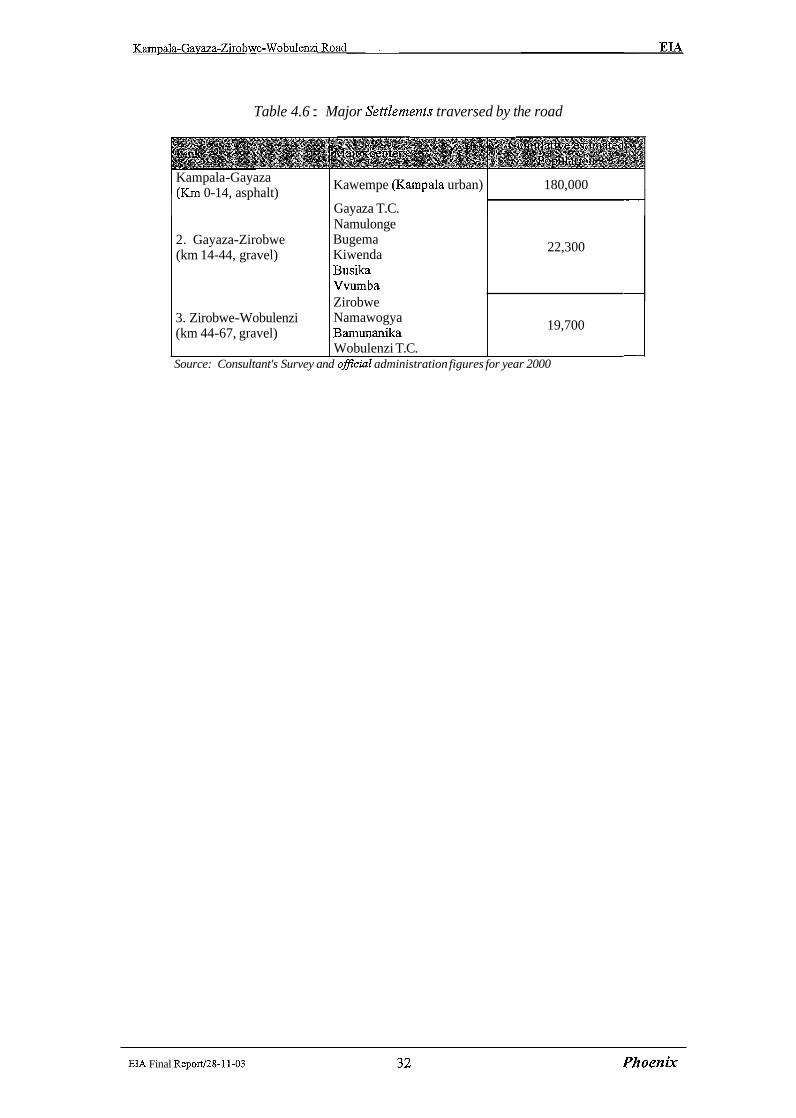
Table 4.6 : Major SettZements traversed by the road
Kampala-Gayaza (Km 0-1 4, asphalt)
Kawempe @ampala urban) 180,000
Gayaza T.C.
EL4 Final Reportf28-11-03 3 2 Phoenix
2. Gayaza-Zirobwe (km 14-44, gravel)
3. Zirobwe-Wobulenzi (km 44-67, gravel)
Source: Consultant's Survey and official administration figures for year 2000
Namulonge Bugema Kiwenda Busika Vvumba Zirobwe Namawogya Bamunanika Wobulenzi T.C.
22,300
-
19,700
-
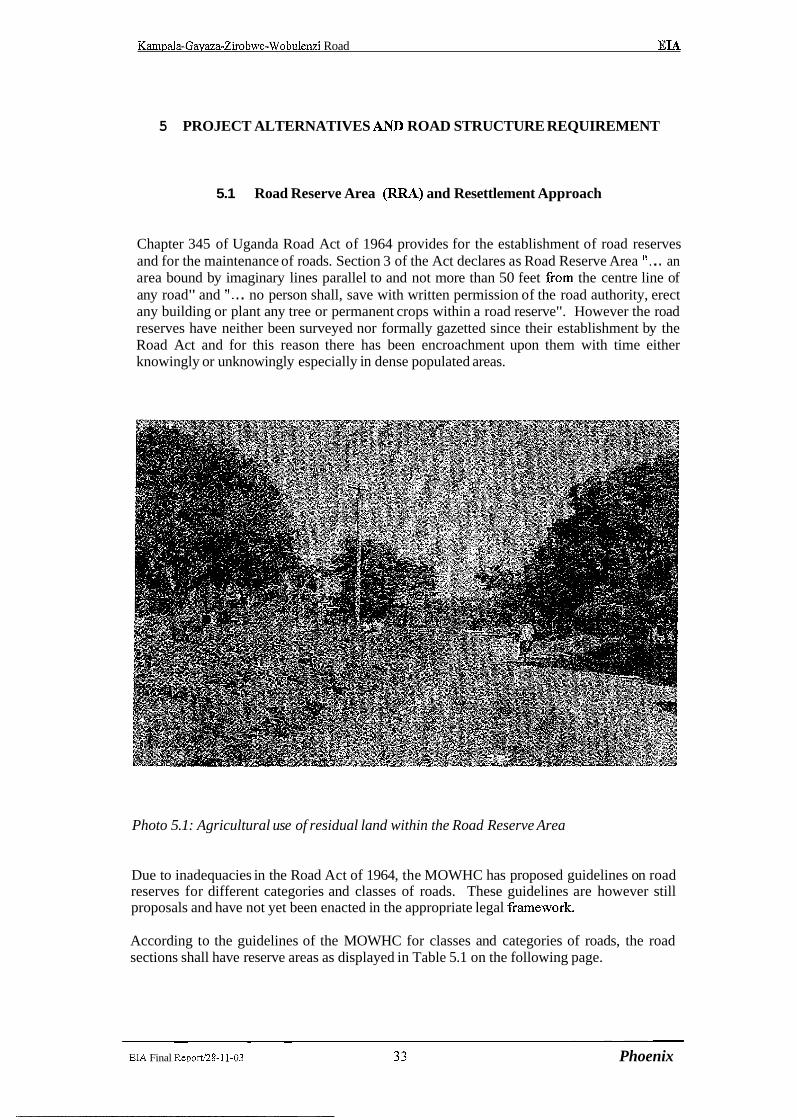
Kamuala-Gavaza-Zirobwe-Wobulenzi Road EIA
5 PROJECT ALTERNATIVES AND ROAD STRUCTURE REQUIREMENT
5.1 Road Reserve Area (RRrP) and Resettlement Approach
Chapter 345 of Uganda Road Act of 1964 provides for the establishment of road reserves and for the maintenance of roads. Section 3 of the Act declares as Road Reserve Area ". . . an area bound by imaginary lines parallel to and not more than 50 feet fiom the centre line of any road" and ". . . no person shall, save with written permission of the road authority, erect any building or plant any tree or permanent crops within a road reserve". However the road reserves have neither been surveyed nor formally gazetted since their establishment by the Road Act and for this reason there has been encroachment upon them with time either knowingly or unknowingly especially in dense populated areas.
Photo 5.1: Agricultural use of residual land within the Road Reserve Area
Due to inadequacies in the Road Act of 1964, the MOWHC has proposed guidelines on road reserves for different categories and classes of roads. These guidelines are however still proposals and have not yet been enacted in the appropriate legal fiarnework.
According to the guidelines of the MOWHC for classes and categories of roads, the road sections shall have reserve areas as displayed in Table 5.1 on the following page.
EIA Final Repod28-11-03 3 3 Phoenix
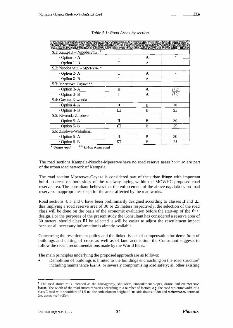
Table 5.1: Road Areas by section
1 S.1: Kam~ala - Nsooba Strn.. * I I I I - Option I - A I A - I
1 S.2: Nsooba Stm..- Mperenve * I - Ontion 2- A I A - 4
S.3 : Mperenve-GayazaA* - Option 3- A I1 A - Option 3- B I A (30)
S.4: Gayaza-Kiwenda - Option 4- A 11 B - Option 4- B I11 B
S.5: Kiwenda-Zirobwe - Option 5- A n B 3 0 - Option 5- B I11 B 25
S.6: Zirobwe-Wobulenzi - Option 6- A n[ B 30 - Option 6- B 111 B
* Urban road ** Urban fiinge road
The road sections Kampala-Nsooba-Mpererwe have no road reserve areas because are part of the urban road network of Kampala.
The road section Mpererwe-Gayaza is considered part of the urban fiinge with important build-up areas on both sides of the roadway laying within the MOWHC proposed road reserve area. The consultant believes that the enforcement of the above regulatioris on road reserve is inappropriate except for the areas affected by the road works.
Road sections 4, 5 and 6 have been preliminarily designed according to classes I1 and JII, this implying a road reserve area of 30 or 25 meters respectively, the selection of the road class will be done on the basis of the economic evaluation before the start-up of the final design. For the purposes of the present study the Consultant has considered a reserve area of 30 meters, should class 111 be selected it will be easier to adjust the resettlement impact because all necessary information is already available.
Concerning the resettlement policy and the linked issues of compensation for demolition of buildings and cutting of crops as well as of land acquisition, the Consultant suggests to follow the recent recommendations made by the World Bank.
The main principles underlying the proposed approach are as follows: Demolition of buildings is limited to the buildings encroaching on the road structure5
including maintenance benns, or severely compromising road safety; all other existing
The road structure is intended as the carriageway, shoulders, embankment slopes, drains and inaintenance berms. The width of the road structure varies according to a number of factors; e.g. the road structure width of a class I1 road with shoulders of 1.5 m, the embankment height of lm, side drains of 3m and maintenance berms of 2m, accounts for 23m.
EM Final Report128-11-03 3 4 Phoenix

Kampala-Gavaza-Zirobwe-Wobulenzi Road EIA
buildings not encroaching with the road will be allowed to remain in place, and after gazetting of the road reserve the construction of new buildings will be prohibited. Crops and trees cutting is limited to crops and trees encroaching on the road structure including maintenance berms, trees cutting is also admitted to the ones located beyond the above mentioned area when they severely compromise road safety. Land acquisition will be limited to the area needed by the widening of the existing road structure.
The evaluation of resettlement cost (see Section 10) has been carried on the basis of the above principles, however it is worth recalling that cost evaluation has to be reviewed at the light of the detailed design of the project road.
5.2 The Project Road: Realignment Options
The engineering design for the Feasibility Study has considered realignment of the existing road in order to comply with requirements of the MOWHC Road Design Manual @DM) or to improve the alignment for safety reasons, and different road type options for capacity/economic reasons. The difference between road type options is essentially a change in the carriageway width of 1.0 m (Class I or IQ or 0.4 m (Class II or Dl). This difference is of little significance in terms of environmental impacts when assessed as outlined above. Consequently assessment focuses on the evaluation of alignment options without differentiating between road type options.
Three alignment options have been studied, although Alignment Option A was abandoned for engineering reasons. A detailed EIA was carried out for alignment B after having done an environmental scooping for the option C. Alignment Option B aims at correcting the lay-out of existing road, whereas Alignment Option C includes major deviations identified to reduce the length of the project road.
Alignment Option B realignments consist of:
the correction of cwes , which currently have radii below the minimum value established by the RDM. These realignments (Table 5.2, following page) will liberate a total of 2. lha of existing RRA and will, simultaneously, require the expropriation of land most of which encroaches onto occupied areas.
the elimination of unnecessary kinks will make for safer vehicle movement. These minor realignments will also require the expropriation of 6.5 ha of land and some resettlement of homesteads and crop cutting.
Alignment Option C included four major deviations from the existing alignment to reduce the road length.
Deviation 1. From km 1 l t570 to km 14t620. This by-pass will reduce the road length of about 650 meters. The present alignment has the double purpose to serve the Gayaza commercial area as well as to allow north-south and east-west traffic. The studied deviation will allow the traffic moving north-south on the project road to bypass Gayaza. The deviation will encroach on an area near Kasangati which is densely populated with the presence of public and private activities (police quarters, prison, schools, cottage factories, etc).
- -
EIA Final Reportl28-11-03 35 Phoenix

Kampala-Gavaza-Zirobwe-Wobulenzi Road EIA
Table 5.2: Location of minor realignments (Alignment Option B)
Source: Consultant's Survey
Deviation 2. From km 31+700 to km 33+100. The realignment (about 1200 meters) has been evaluated in order to eliminate four bends; the road section length will be reduced of approximately 200 m. This realignment, crossing an intensive farmed area, has the purpose of optimising the road design and reduce cost for road users.
Deviation 3. From km 33+500 to km 39+100. This deviation will reduce the actual length of this section of road of about 480 meters. The deviation starts at Vvumba village and traverses several large banana and coffee plantations, thickets and woodlantl with the presence of large trees such as muwafu (Conariurn Schweinerfurthii) and mvule (Melicia Excelsa). After coinciding with the existing road at Ndeeba village, the deviation continues north by-passing the market area of Bulami village. This realignment has the purpose of optimising the road design and reduce cost for road users.
Deviation 4. From km 48+600 to km 55+700. With the deviation (7.247 km), the project road length will be reduced of about 1500 meters. After Namawogya trading center, the deviation leaves the existing alignment and leading north-west enters in a environmentally balanced rural habitat. Noticeable is the fertility of the soil and the presence of the original vegetation. Compounds are surrounded by plantations, mainly bananas (matoke). A large number of mangoes and jack fiuit trees have been evaluated on the basis of a representative sample. The area is served by feeder roads and paths. The deviation follows the feeder road serving Magogo village area and after crossing Kayiwagobe river, reaches Kikabya and Kisaku village areas where
EI.4 Final Report128-11-03 3 6 Phoenk

Kampala-Gayaza-Zirobwe-Wobulenzi Road EIA
turns west to join the project road at Bamunanika. This realignment has the purpose of optimising the road design and reduce cost for road users.
The positive and negative impacts of the studied deviations can be summarised as follows:
Positive impacts: - Reduction of the length of road with economic benefit for road users. - Improvement of vehicle circulation and road users safety - For deviation nOl, reduction of vehicles pollution due to the diversion of traffic
directed north-south and not needing to stop in Gayaza (deviation no 1). The reduction will not be significant because North-south transit trac accounts for 16% of the total traffic of the road section.
- Valorisation of agricultural production in neighbouring areas (deviation no 4)
Negative impacts: - Expropriation of farmland - Destruction of trees and crops - Dislocation of a large number of homesteads and consequent involuntary
resettlement (mainly for deviation no 1 and 4). - Disruption of on-going commercial activities along the existing alignments
(deviations no 2,3, and 4). - Great disturbance of a well balanced habitat (deviation no 4). - Exclusion fiom the upgraded road of Barnunariika health centre, teacher's college
and part of the commercial centre (deviation no 4).
The proposed deviations together will reduce the length of the project road of about 3 kilometers and perhaps will reduce also the construction costs. The deviations will not interfere negatively with the surrounding environment since it is the same environment crossed by the existing road, but some reflections on the validity of deviations, apart fiom the positive and negative impacts mentioned above, should be taken into account.
The sections of the existing road excluded by the deviations do not present either engineering difficulties or problematic impacts on the environment and resettlement caused by the road upgrading works.
The road Gayaza-Zirobwe-Wobulenzi, the section of project road where the proposed deviations are located, is not an arterial road like the Kampala-Wobulenzi-Gulu road. Traffic is limited and mainly directed to the rural settlements actually linked by the existing road.
The deviations will cut-off economic activities already established along the excluded road sections and will penalise people that have invested in such activities.
The deviations will encompass intensive fanned areas, causing the destruction of about 25 hectares of cultivated land, mostly silbsistence crop fields. For the affected farmers will be diEcult to found new land for farming. At the same time more than 100 homesteads, encroaching the deviations, risk to be dislocated with the consequent resettlement problem. It is interesting to notice that during consultation meeting with stakeholders, farmers were more worried to loose the farm than to have the house displaced. Almost the totality of f m e r s are squatters and have no title on land but their subsistence and incomes depend on the land they are farming. In exploited areas,
EM Final ReportI28-11-03 37 Phoenix

Kampala-Gavaza-Zirobwe-Wobulenzi Road EIA
like the ones encompassed by the deviations, will be dificult for displaced people to found new land for farming.
- The rising of land prices and the settlement of new comers along the devialtions, will turn badly for resident farmers and maybe cause of discontent and conflicts.
In the light of the above reflections, the solution to upgrade the existing road by Re,alignment options B was considered for environmental assessment.
EL4 Final ReporV28-11-03 3 8 .Phoenix

Kampala-Gavaza-Zirobwe-Wobulenzi Road EL4
6 ENVIRONMENTAL IMPACTS APJD MITIGATION
6.1 General
In line with the Terms of Reference, the study has adopted the environmental assessment methodologies advised by the World Bank the National Environment Management Aurthority guidelines and the Statute (1994 and1995 respectively), to analyze the direct and indirect impacts stemming from:
the road construction process, and: the use of the road after its opening to service.
Accordingly, the impacts are categorized taking notice of: a. their relations with the project : direct and indirect impacts b. environmental receptors: ecosystems, human habitat
a. Direct and indirect impacts: Upgrading project road will exert direct short term impacts limited to the construction period. Direct long-term impacts will appear during and after construction, related both to road construction works and the subsequent moderate increase in traffic volumes. Indirect impacts will stem fiom muItiplier effects on ecosystem and human habitat, induced by increase in traffic volumes and greater accessibility throughout the project area.
b. Environmental receptors have been distinguished into two categories: a natural ecosystems: forests, grasslands, swamps, with their characteristic wildlife
human modified ecosystems: focusing upon the farmlands, range land and constructions affected by road upgrading works (dislocation and resettlement)
Table 6.1 on the following page displays an overview of the direct and indirect impacts generated by Kampala-Gayaza-Zirobwe-Wobulenzi Road Upgrading Project, specifying the environmental and social receptors, the sources of impact and the related time frame.
6.2 Impact Evaluation Approach
The impacts of the project road upgrading are assessed in relation to the Construction phase and the Post construction phase since the control and mitigation of the two phases are undertaken by different agencies.
The Construction phase includes all impacts resulting from the construction of the road and the activities of road construction itself. These will largely be under the control of the Contractor under the supervision of MOWHC.
The post-construction impacts are the more indirect impacts resulting from the changes in the environment due to the road upgrading.
EIA Final Report128-11-03 3 9 Phoertk

Table 6.1 Potential Impacts of Kampala-Gayaza-Zirobwe- Wobulenzi Road Upgrading Project
Ecosystems I I [TT~ros ion fiom fiesh roads cuts, silting of water courses I 2 Destruction of vegetation, loss of agricultural land 3 Water and soil pollution 4 Construction of detours and haul roads 5 Environmental, social disruption by construction camps 6 Loss of human habitat 7 Noise and vibration
Road upgrading works (2002-03)
Employment generated by the project Local SME activities related to sub-contracting of work
Modified Human I
1 components 2 .*= ..*- .z t- : . . i . :-,. @ $ ~ < $ : ~ $ $ ~ @ : J - ~ ~ ~ $ ~ ~ ; ~ ~ ~ ~ ~ ~ ~ ~ $ ( @ $ ~ ,.wo.r~s2 @d '@m&f~&&:
1 Landscape deterioration by land take and earthworks 2 Material borrowing and quarrying 3 Creation of breeding habitats for disease vectors 4 Surfacelgroundwater pollution, interference on
overlandfsubsoil drainage 5 Soil erosion and sedimentation 6 Noise, vibration and dust, deterioration of air quality 7 Road safety hazards and livestock kills due to traffic and
speed increase 8 Dislocation and compulsory resettlement due to road
Road works (2002-03)
Road use (2004 onward)
1 2 1 points ~ & e r maintenance of social and environmental I I
2 agriculture Excessive land clearing 3 Aggravation or creation of disease, pest and weed
transmission corridors 4 Loss of cultural identitv and sense of locality
1 Economic growth 2 Improved community services
EIA Final Report128-11-03 40 Phoenljc

Kampala-Gavaza-Zirobwe-WobuIenzi Road EL4
6.3 Environmental Impacts of the Existing Road
The environmentally negative impacts exerted by the present unpaved road include: - deterioration of air quality - noise of vehicular movement, enhanced by low-speed driving - dust during non-rainy periods, water stagnation in wet seasons - traffic accidents
6.3.1 Health Effects Of Present Road Use Some of the impacts of present traffic may affect the health of village residents along the road, causing lung and bronchial disorders. Clouds of dust may also cause accidents by hindering visibility to drivers. Traffic growth has been restrained, in part due to the poor road condition, curbing such negative impacts as air pollution and noise. From the social viewpoint, however, limited accessibility hinders the development of health services, leading to lower possibility to cure the diseases related to the poor environmental quality of the existing road. Similarly, water supply infrastructure suffers from lack of maintenance, compounded by transport cost and difficuIt accessibility. Therefore, local communities rely more and more on polluted water sources, adding to the critical picture of human ecology features across large tracts of the project area.
6.3.2 Current Traffic Accidents Of all the places along the Kampala-Gayaza-Zirobwe-Wobulenzi road, Zirobwe-Wobulenzi section seems to be the most prone to accidents. The accident rate of this road section is undoubtedly due to the narrow road conditions. Table 6.2 presents the traffic accident data recorded for Gayaza-Zirobwe-Wobulenzi road over the last decade.
According to local police officers, most accidents reported on the gravel section are not severe and mainly involve cyclists and school children. ~ s ' a matter of fact, only two fatal accidents, caused by capsized vehicles, occurred over the last two years. No real black spot has been identified by the traffic police, save the small section linking the rural centre of Bamunanika (km 57.2) and the Lutete Junction (km 56.2), one km away. This part of the road is narrow, saggy and lined by schools, one health center and a weekly market area. Still according to the police, accident relief services are inadequate and victims wait a long time before being attended by traffic police, ambulances and wreck hauling trucks.
Table 6.2 : Traflc accidents along Gayaza-Zirobwe- Wobulenzi Road, 1989-99
~ o u F ~ o l i c e s z n s in ~irobwe, Burnunanika and Bugerna
EIA Final Reportl28-11-03 41 Phoenix
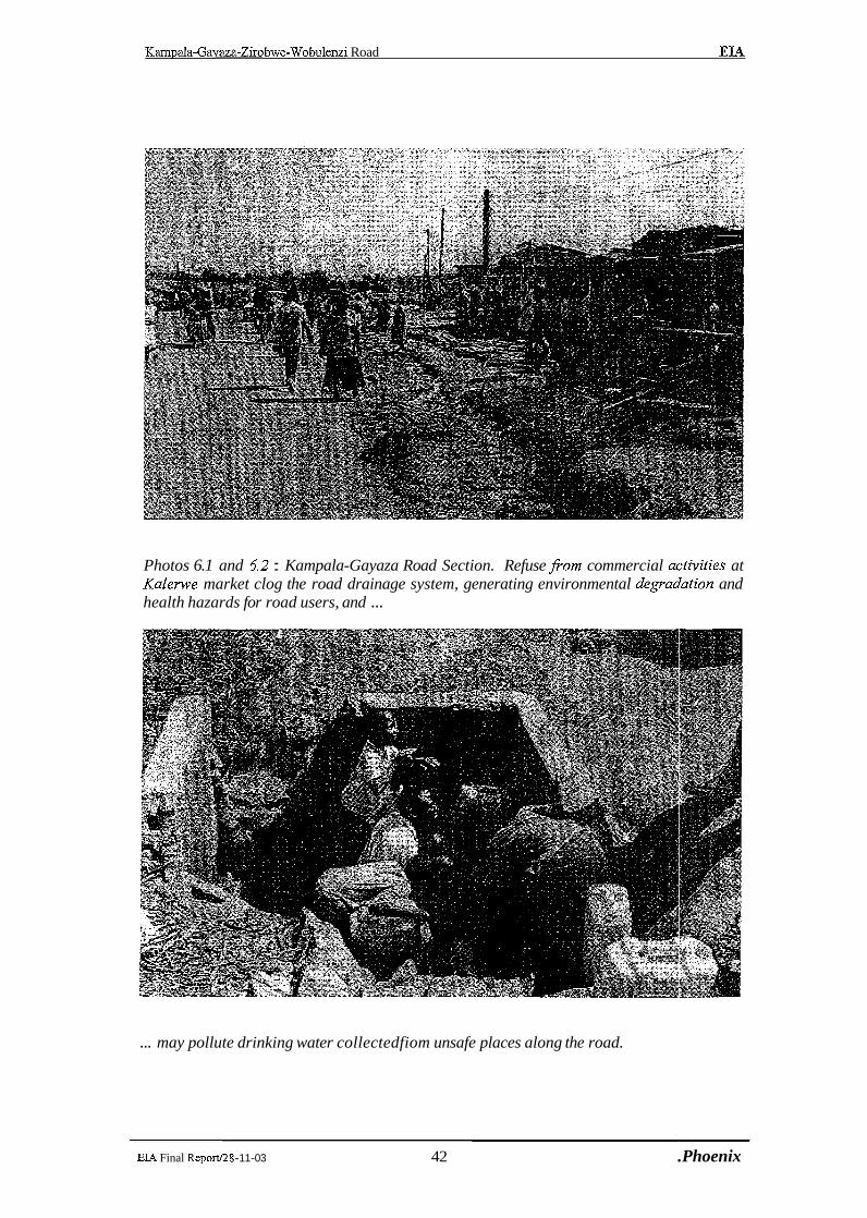
Kampala-Gavaza-Zirobwe-Wobulenzi Road EIA
Photos 6.1 and 6.2 : Kampala-Gayaza Road Section. Refuse fiom commercial activities at Kalerwe market clog the road drainage system, generating environmental degraa'ation and health hazards for road users, and ...
... may pollute drinking water collectedfiom unsafe places along the road.
EIA Final Reportl28- 11-03 42 .Phoenix
Kampala-Gayaza-Zirobwe-Wobulenzi Road EL4
6.4 Planned Road Works
During the project implementation process, ecological hazards will stem from numerous works components, as quarries, detours and hill cuttings. All the considered impacts are direct, as they derive from site operations. The most hazardous work items are dimensioned by the following key indicators (Table 6.3).
Table 6.3 : Indicative quantities of road upgrading works
/ 3 .a (Reclamation of land for road structure 1 ha 155 1 1
1 3 1 1 Raise of embankment I m3 1 354,000 1
2
1 .b 1 .c 2.a 2.b 2.c
4 5
Land takes for realignments Land takes for deviations
6 7
6.5 Traffic Growth Forecasts
-
Borrow pits, quarries Borrow pits, quarries (surface) Borrow its, quarries (extracted materials)
Cuttings (volume) Pavement (local aggregates)
8 1 1 Detours and haul tracks
When the upgraded Kampala- Gayaza-Zirobwe-Wobulenzi road will open to service, traffic will increase principally along the new paved section and its feeder network. In fact, in the 53 km of road from Gayaza to Zirobwe and Wobulenzi, tr&c volumes are forecast to more or less tripled during the project's economic lifecycle (2004-2024). The present and projected daily traffic volumes on the project road are shown in Table 6.4.
ha ha
Culverts (rehabilitation & new construction) Construction camps
Table 6.4 : Present and projected daily trafJic volumes on Kampala-Gayaza-Zirobwe- Wobulenzi Road
8.6 65.0
-
nr
ha m3
m3 m3
Source: Consultant's estimates ha
-
9 14.5
300.000
720,000 126,600
nr ha
2.8
114 2
Kampala-Mperenve Mperenve- Gayaza Gayaza-Kiwenda Kiwenda-Zirobwe
Source: Consultant's trafic survey
Zirobwe-B amunanika Barnunanjka-Wobulenzi
In general, transport development has mixed effects, both negative and positive, on environmental receptors as air, soil, water and living organisms. In some cases, positive and
10,618 3,936 622 332
EIA Final Report/28-11-03 43 Phoenix
26,712 9,932 1,766 1,003
185 337
567 1,034
negative impacts will interfere with each other problematically and onIy the: way the problems are handled will strike their fmal balance.
All the above road use impacts - either positive or negative, direct or indirect - will be long- tern ones, unfolding over the whole economic life-cycle of the project.
6.5.1 Impacts Of Road Works and Future Road Use
6.5.2 Short-term Negative Impacts of Road Works For a period of about 2 years, the contractor(s) will install camps and working sites, exploit quarries (see Figure 4.2, p27 to Figure 4.5, p30), open up detour and haul tracks. The construction and dismantling of makeshift camps may alter the space surrountling local villages. To mitigate the potential impact, the construction enterprises and their sub- contractors must adopt the prevention and mitigating measures indicated below, in italics. The condition that these works will be carried out will be part of the contract documentation and their cost will be contained in the construction cost of the project works.
6.5.3 Short-term positive impacts of road works Out of a total project cost of 26 million US Dollars, offshore costs will represent about 60%. The national cost component will be split almost half and half between taxes and local costs. In the districts of the project area, about 2.5 millions US$ will be spent for both skilled and unskilled local manpower (1 million) and supply sub-contracts (1 -5 million).
6.5.4 Long-Term Negative Impacts Of Road Works If poorly managed or not complying with design specifications, road works may disfigure landscapes and negatively affect land use.
6.5.5 Long-Term Positive Impacts Of Road Works The road will be a major step in the socio-economic development of an agricultural area close to Kampala city. In the meantime, regional authorities and local communities will have to improve the infrastructure and install additional facilities to ensure a proper fallout of the expected benefits.
EL4 Final Report128-11-03 44 PhoenIjc
Kampala-Gavaza-Zirobwe-Wobulenzi Road EIA
6.5.6 Direct Impacts Of Future Road Use The direct impacts of additional traffic on the physical and social environment will be either negative or problematic. All of them are potentially long-term ones. In general, however, such impacts will not represent a severe deterioration as compared with the present situation.
6.5.7 Negative Impacts : The present ecological conditions in project area can be aggravated by rapid demographic increase and the consequent spreading of settlements and farms over increasingly marginal soils. The residual natural resources are concentrated in the wetlands in the northern part of the project area. In dry lands, almost all suitable land for farming has been exploited, wiping out most of the original begetation. The vegetation cover will disappear and will take considerable time to recover to its natural state. This is most especially where borrow pits and Quarry sites exploitation will be effected. The natural status of the eco-system of such afFected sites will be changed and serious rehabilitation will be called for.
Exploitation of the Quarry site and Borrow pits will generate stone dust that will affect the near by communities. Blasting and noise from equipment and the risks of frying will affect farming acvtivities and settlement at such 1ocations.Estalishment of Contractor labour camps will exert pressure on the existing stock of the fuel wood in the area .Fuelwood will be required in heating the Bitumen and cooking at construction camps.
There is likely growth of demographic density, along the project road. The road will act as a pulling factor in respect to attracting linear setlements. More pressure on the available social services is expected.
Road upgrading brings about great benefits in terms of access to potential farmlands, crop marketing opportunities and multiplier effects on regional rural revenues, natural resources often bear the hidden costs of such development. To curb the costs of environmental degradation entailed by increased pressure of population and economic activities on the natural resource base and achieve sustainable rural growth, protection measures must be gradually phased in.
6.5.8 Positive, Indirect Impacts Of Future Road Use Among the transport-depending economic and administrative activities, those ones which deserve greatest attention in terms of supportive investments are public services.
6.5.9 Impacts and Mitigation Measures
Below is a description of the expected impacts and the recommended mitigation measures. The significance of the identified impacts is rated in Table 6.7, page 56, on a scale of low : moderate : high.
EIA Final Repod28-11-03 45 Phoenix

Kamuala-Gavaza-Zirobwe-Wobulenzi Road EIA
6.5.10 Biophysical Environment
6.5.10.1 Erosion fiom new road works
Expected impacts Erosion, caused by wrong work methods leaving soils unnecessarily exposed, stems from excavations, detours, haul tracks and may lead to silting of natural drainage ways.
Recommended mitigation measures As road works proceeding, abandoned excavations, detourshaul tracks will be ripped up and topsoil reinstated.
6.5.1 0.2 Water and soil pollution
Expected impacts Due to construction methods or accidental spillage, works may pollute soil imd water especially at river and swamp crossings. Culverts will be installed or upgraded all along the road, discharging particulate matter and stirring river bed deposits into suspension. While large suspended parts settle quickly, the finer ones last longer, but turbidity will be short- lived since stream crossings are built in a few weeks. Drainage channels will be dug to drain run-off from the road surface and its vicinity. In flat terrain, drainage channels will be prolonged claiming land take. In rolling terrain, as off-side structures may erode the soil causing pollution of water sources and lakes. Workers will dispose human and associated excreta a short distance from the road under repairs. This could lead to spread of gastro- enteric diseases through contamination of water resources with the human waste.
Recommended mitigation measures As the road crosses permanent and seasonal wetlands, care should be taken in the construction of culverts. Water for construction will be drawn fiom surface waters and no long-term impact on aquifers is expected, as works will not demand exhaustive water amounts. Accidental spillage of fuel or chemicals is a risk, but spillage is likely tcs be local and remediation should be easy. Spillage to water course is harmful for all living beings. The contractor must exercise utmost care to avoid such hazards. Proper pit latrines for road workers shall be installed. Careless behaviour will be sanctioned
6.5.10.3 Air pollution and dust
Expected impacts The existing road environment is extremely dusty in dry weather due to vehicles travelling at high speeds along the road. Roadside plants and crops are covered with a thick layer of dust, which must reduce yields of the crops. Local residents are constantly exposed to high level of dust, which must also cause health problems. To transport workers tolfrom sites, it has been assumed, for the purposes of assess~nent, that three camps will be built, that occupy 9 Ha. in total. The camps will be located near Gayaza, Zirobwe. For logistic purposes may a small camp is needed at Wobulenzi. Heavy machines will open detours or haul tracks and excavate pits. In dry weather, dust will distmb local people. Hot asphalt will generate hazardous smoke fumes to the environment. Construction workers will be exposed to high levels of dust over the construction period.
EIA Final Reportl28-11-03 46 .Phoenix

Kampala-Gavaza-Zirobwe-Wobulenzi Road EM
Recommended mitigation measures The nuisance will be transient and good work practice will curb it. Dust is already an every- day nuisance close to the existing gravel road. Wetting. with water the detours and haul tracks as well as the road under construction will minimize dust. The contractor will advise local households on dust and other dangers. The construction of a sealed road will eliminate the existing problems of dust during dry periods. The respiratory problems associated with dust should therefore be significantly reduced when the road uograde is completed
6.5.1 0.4 Noise and vibration
Expected impacts Plant and construction traffic will make vibration and substandard houses close to the road may collapse. The noise from construction plant will interfere with school learning activities and worship in mosques and churches within the road area. Vibration and gas emission will increase with the increasen in traffic after the road is upgraded.
Recommended mitigation measures During construction, the nuisance will be transient and good work practice will curb it. The contractor will advise local households schools and institutes on noise, vibration and other dangers. After construction, forecast traffic growths are moderate. Speed limits and exhaust emission controls must be enforced, especially in towns. Hedges and trees must be planted along the road. Traffic police, forestry staff, local communities and road users must be mobilised.
6.5.1 0.5 Landscape deterioration by earthworks
Expected impacts The upgraded road will require new land take along the gravel road section. About 21,000 sqm of soil will be exposed to erosion by the cuts. The project road traverses some plains and wetlands on small embankments, which require raising. Quarrying entails vegetation clearing and transportation of materials, causing unsightly effects. Quarrying and disposal can destroy the economic and aesthetic value of land. Abandoned borrow pits along the existing road are example of their damaging effects.
Recommended mitigation measures The design cutlfill balance minimises net materials import. Good construction methods will minimise visual impairment. The exposed cut areas be planted with grass; ideally a mixture of indigenous grass seeds (paspalum grass). Re-grassing should be carried out in stages as construction proceeds. This will reduce erosion and sedimentation. Slope failures of embankments will be minimised by implementing the road design manual recommendations. In addition, borrow pits should be rehabilitated after use and this should be done by the contractor according to MOWH&C General Specifications. The contractor should undertake the borrow-pit rehabilitation work in consultation with the land owner.
EIA Final Report128-11-03 47 Phoenrjc
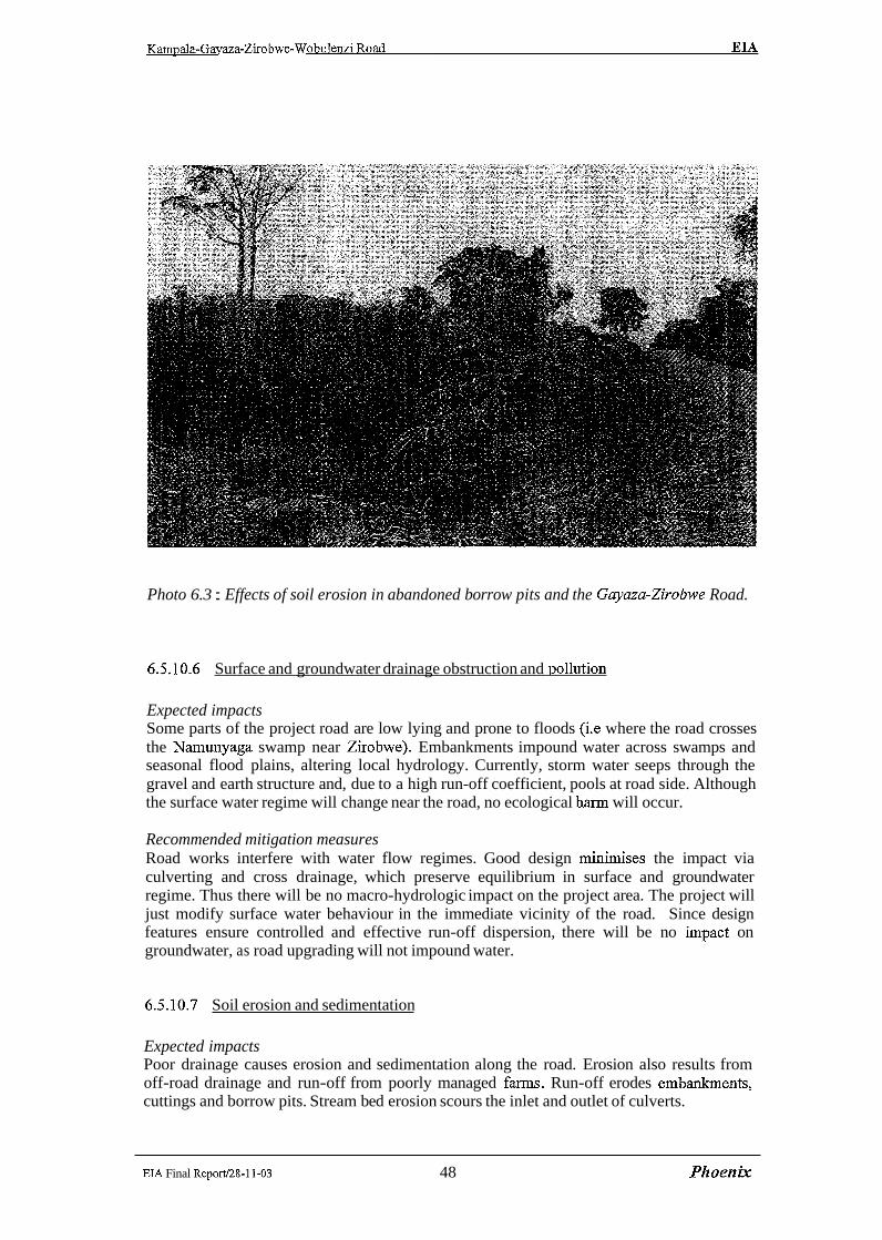
Photo 6.3 : Effects of soil erosion in abandoned borrow pits and the Gayaza-Zirobive Road.
6.5.10.6 Surface and groundwater drainage obstruction and ~ollution
Expected impacts Some parts of the project road are low lying and prone to floods (i.e where the road crosses the Narnunyaga swamp near Zirobwe). Embankments impound water across swamps and seasonal flood plains, altering local hydrology. Currently, storm water seeps through the gravel and earth structure and, due to a high run-off coefficient, pools at road side. Although the surface water regime will change near the road, no ecological hann will occur.
Recommended mitigation measures Road works interfere with water flow regimes. Good design minimises the impact via culverting and cross drainage, which preserve equilibrium in surface and groundwater regime. Thus there will be no macro-hydrologic impact on the project area. The project will just modify surface water behaviour in the immediate vicinity of the road. Since design features ensure controlled and effective run-off dispersion, there will be no impact on groundwater, as road upgrading will not impound water.
6.5.10.7 Soil erosion and sedimentation
Expected impacts Poor drainage causes erosion and sedimentation along the road. Erosion also results from off-road drainage and run-off from poorly managed farms. Run-off erodes embsmkments, cuttings and borrow pits. Stream bed erosion scours the inlet and outlet of culverts.
EIA Final Report128-11-03 48 .Phoenix

Kampala-Gavaza-Zirobwe-Wobulenzi Road EL4
Recommended mitigation measures Careful engineering design and re-vegetation will control erosion of embankment, drains and adjacent land. Improper works management may spark erosion processes and scar adjacent slopes. Erosion prevention measures foresee that all areas impacted by the works be re- vegetated using reinstated topsoil with local species as soon as the sites are closed. Local environmental authorities will inspect that such rules are complied with.
6.5.11 Human Environment
6.5.11.1 Loss of farmland and habitat
Expected impacts Crops, trees, topsoil will be cleared from the project road alignment. Haul tracks will be opened for wagons to shuttle totfrom pits, with extensive bush clearing. Camps and detours will also be created. Works will disturb habitat close to the road. The impact of this is cumulatively quite high, but the major impact is to the farmers or land owners resident in the areas interested by the road works.
Recommended mitigation measures No protected species is likely to be disturbed. As most of road upgrading works will interest the existing alignment, the impact on farmland and habitat will be small. On minor realignments and deviations, vegetation clearance should be limited to the area effectively needed for road construction. Farmers will be warned to harvest on time and compensated to create new farms. Land is available near the villages, so the harm should not be great. Crops and planted trees will be reinstated on completion.18 borrow pit sites, 15 of which are already under exploitation, have been already identified. According to the estimated potential of existing borrow pits, opening of new pits may not be necessary.
6.5.11.2 Safety risks during construction
Expected impacts The working site is a dangerous place. Children are vulnerable to heavy plant and machinery. Public safety may be a problem in two areas: (a) The immediate vicinity of the plant; (b) the detours around the working front, unfamiliar to drivers a n d of lower standards than permanent roads. There will also be additional traffic on the detours for construction needs.
Recommended mitigation measures Plant operators must ensure that children are not allowed close to the machines. Accidents are likely to occur to labourers. Effective management of the camps and working sites will prevent nuisance and accidents. Detours and temporary haul tracks shall be well planned, signed and maintained to reduce safety risks for drivers and pedestrians.
6.5.1 1.3 Health hazards
Expected impacts Road construction exposes the labourers and the general public to bronchial and other pathological risks. Moreover, the most serious health concern haunting local communities is AIDS-HIV. The disease can spread as a result of the influx of construction workers into areas. Even though the rate of infection is already high both in Kampala suburbs and the settlements along the road, the presence of the worker may further accelerate the epidemic.
EIA Final Reportl28-11-03 49 Phoenisc
Recommended mitigation measures Provision of working figures and good camp management is required. First aid facilities shall be installed in all camps. AIDS-HIV should be closely monitored under the responsibility of the medical unit of the Contractor(s), which should proceed to regular checks of the health status of the workers. One NGO, Plan International, is present in the area and is already operates AIDS-HIV monitoring facilities in the districts traversed by the road.
6.5.1 1.4 Emvlovment generated by the project
Expected impacts Road works will create job opportunities for some 100 workers recruited on the spot along each particular road section, with the advantage of social harmony between the workers and
. local communities. The influx of labour will also increase commercial revenues, thanks to - multiplier effects.
Recommended enhancement measures Workers should be briefed by the contractor on their tasks and the prevention o~f inherent risks. The contractor will also be responsible for on-the-job training of semi-skilled labour force. Work certificates will be given to skilled and semi-skilled workers by the contractor and the Labour Office upon good performance.
6.5.11.5 Benefits for local SME
Expected impacts Part of the works will be sub-contracted to local enterprises, with economic spill-over benefits in terms of multiplication effects and spread of construction know-how and private sector capacity building.
Recommended enhancement measures The Contractors will be given a roster of local SME by the competent regional authorities. International credit lines should be mobilised in due advance to support local entrepreneurial capacities in connection with the project.
6.5.11.6 Water-borne diseases.
Expected impacts Abandoned pits and quarries filled with rain water may represent a danger for children. Stagnant water in borrows pits and quarries becomes breeding habitats of pests and disease vectors (malaria, schistosomiasis, d etc.).
Recommended mitigation measures The contractors will reinstate, in consultation with the local community, the borrow pits and quarries areas to permit the re-establishment of vegetation. The Consultant suggests to plant trees for charcoal and firewood production (i.e. gassia "cassia spectabilis", omusasa "sapium ellipticum") or for timber and environmental protection (i.e. mvule " melicia excelsa ").
EIA Final Report128-11-03 50 Phoenrjc
Kampala-Gavaza-Zirobwe-Wobulenzi Road EIA
6.5.11.7 Displacement and Involuntaw Resettlement
Expected impacts Resettlement of homesteads encompassing the RRA will not be the major issue where the project road follows the existing alignment. The impact on resettlement will be much higher in the areas where minor realignments are foreseen by the road works. The smoothening of curves (mainly located in village trading centres) and rectification of kinks will affect homes and shops.
Recommended mitigation measures The Consultant has taken into consideration the possibility of relaxation when the project road encroaches some villages, but there is still sufficient width to construct the road, to allow the buildings to stay in the road reserve.
.Displacement and involuntary resettlement impacts are detailed in section 8.
6.5.1 1.8 Expansion of the feeder road network
Expected impacts The road project area is densely settled, with scattered hamlets and homesteads. The development of service roads and detours during the construction phase will enable some existing tracks and footpaths to be transformed into motorable feeder roads.
Recommended enhancement measures In collaboration with local communities, the Local Governments should select the service roads and detours which can be usefully transformed into permanent feeder roads. The competent authorities should earmark the funds and the local participation to ensure their maintenance after the end of the road upgrading works. The integration of the new feeder roads into the rural transport network is likely to regard a total length estimated at about 15 km.
6.5.1 1.9 Hazards for livestock
Expected impacts Small herds trek along the shoulders of the project road in Luwero district and animals cross the road itself
Advised mitigation measures Speed limits and installation of road signs indicating the presence of cattle, especially on the stretch between Bulami (km 37,O) and Barnunanika (km 57,0), will help curbing accident risks. The collaboration of traffic police and local communities will be essential.
6.5.1 1.10 Activation of transmission corridors of diseases, pests and weeds
Expected impacts The upgrading of the road makes will enhance this impact. Congestion in settlements along the road may intensify diseases as malaria, dysentery, meningitis, measles, aids, or spark epidemics as cholera, typhoid.
EL4 Final Reportl28-11-03 5 1 Phoenix
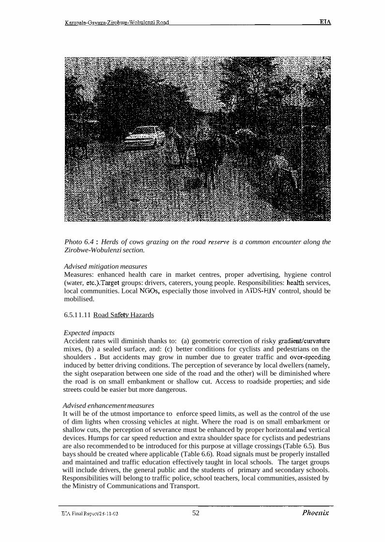
Photo 6.4 : Herds of cows grazing on the road reserve is a common encounter along the Zirobwe- Wobulenzi section.
Advised mitigation measures Measures: enhanced health care in market centres, proper advertising, hygiene control (water, etc.).Target groups: drivers, caterers, young people. Responsibilities: health services, local communities. Local NGOs, especially those involved in AIDS-HTV control, should be mobilised.
6.5.1 1.1 1 Road S afetv Hazards
Expected impacts Accident rates will diminish thanks to: (a) geometric correction of risky gradientlcurvature mixes, (b) a sealed surface, and: (c) better conditions for cyclists and pedestrians on the shoulders . But accidents may grow in number due to greater traffic and ovel--speeding induced by better driving conditions. The perception of severance by local dwellers (namely, the sight oseparation between one side of the road and the other) will be diminished where the road is on small embankment or shallow cut. Access to roadside properties; and side streets could be easier but more dangerous.
Advised enhancement measures It will be of the utmost importance to enforce speed limits, as well as the control of the use of dim lights when crossing vehicles at night. Where the road is on small embarkment or shallow cuts, the perception of severance must be enhanced by proper horizontal and vertical devices. Humps for car speed reduction and extra shoulder space for cyclists and pedestrians are also recommended to be introduced for this purpose at village crossings (Table 6.5). Bus bays should be created where applicable (Table 6.6). Road signals must be properly installed and maintained and traffic education effectively taught in local schools. The target groups will include drivers, the general public and the students of primary and secondary schools. Responsibilities will belong to traffic police, school teachers, local communities, assisted by the Ministry of Communications and Transport.
EM Final Reportl28-11-03 52 Phoenix

Kampala-Gavaza-Zirobwe-Wobulenzi Road EM
Table 6.5 : Location of extra shoulders in village crossing
- - -
1 25.2 1 Kiwenda 1 300 1
14.0 - 17.7 20.5 22.6
I 1 26.8 Lukvamu 200 I
A Magigye
Busukuma ppp
Namulon ne
400 - 200 200 400
28.0
1 44.2 1 -
Zirobwe I 700 I
33.5
Bugema
1 58.0 1 Bamunanika I 400 1
300 31.1
Vvumba
I 49.3
1 61.9 1 Lukvamu I 200 I
200
1 67.0 1 Wobulenzi I 400 I
Busika
200 1 37.9
Narnawogya
Source: Field survey
200
Bularni
300 55.5
Table 6 . 6 Location of bus bays
44.5 Taxi park Zirobwe 600
Lutete
Namawogya junction 600 Health Centre Bamunanika 600
200
Source: m d survey
6.5.1 1.12 Increased demographic pressure and unsustainable land use
Expected impacts In-migration will raise pressure on land, boosting ribbon development along the road and triggering land price rises. Higher prices of land are often viewed as positive impacts, which they might be when everyone owns their land. Less than 30% of the people own their land in the project area, so that the benefits of price rises will be felt by a minority, while the great majority will feel the disadvantages of hire rents. Farms will be bought by newcomers. Albeit consensual, such transactions will create landless households, pushing marginal
EIA Final Report128-11-03 53 Phoenix

farmers to seek land in remote places and spreading extensive, environment-hostile cultivation practices.
Advised enhancement measures Town planning capabilities must be strengthened to prevent congestion of construction just beyond the road reserve area. Rural co-operatives and credit lines should be assiste:d in order to sustain smallholders and avoid excessive sale of farmland to commercial farming companies. Agricultural extension networks should also be fortified, in order to ensure sustainable cropping patterns and avoid soil depletion due to practices maximising immediate returns, as it usually happens when land is leased by owners to landless farmers who care for just immediate return and neglect the long-term effects of poor soil management.
6.5.1 1.13 Improved Communitv and Environmental Services
.. . Expected impacts
' Improved transport will help the distribution of drugs. Patients will receive faster medical attention. Health workers will enjoy easier access to work places. More doctors and nurses
. - may reach the northern part of the project area.
Advised enhancement measures Regional investment budgets should target the rehabilitation of water supply, rural and urban health services and educational facilities, taking advantage of lower transport costs and better accessibility to the road influence zone.
6.5.1 1.14 Economic benefits
Expected impacts Traffic increase will benefit the national and local economy, stimulating inveslment and intensifying trade. Household earnings should improve as a result of better access to the area. Farmers can be able to sell produce fiom stalls on the roadside and additional jolbs will be created with the development of new small scale industries along the road. At the same time, public services will become more di&e and delivered at cheaper costs. The fallout of such benefits will however be constrained by the lack of ancillary facilities to receive additional traffic and sustain the offer of local products and private, public services.
The cost of crops hauled fiom the project area to Kampala urban markets will be reduced. At present, food staple crops as banana plantain (matoke) and sweet potatoes (lumonde) are transported to Kampala fiom Kalagala, Zirobwe and Bamunanika production areas at the cost of 450-500 and 900-1 100 USh per ton/km, respectively. Due to the road c~onditions, mainly pick-up cars are utilized along the project road for the transport of staple crops, keeping high the transport costs. The likely cost after the rehabilitation of the road is expected to drop respectively to 350-400 and 650-700 USh per tonflun as the same rates paid utilizing trucks on the tarmac road Wobulenzi-Kampala via Bombo. A lowering of the supply cost will increase the quantities sold on the market. In fact, although the farmlands of the project area are filly exploited and in some cases overexploited, the farmers will have the opportunity to intensify crop productivity, re-injecting transport cost savin,gs in the purchase of production input as fertilisers, pest control products and post-harvest facilities. In fact, it has been widely observed that cropping patterns are usually intensified and agricultural infrastructures developed along rehabilitated road sections in rural areas;.
EIA Final Report/28-11-03 54 .Phoenix

Kam~ala-Gayaza-Zirobwe-Wobulenzi Road EL4
Improved access must be matched by an expansion of capacity of the existing health and educational establishment to avoid congestion, which is already high especially in the major hospitals and clinics of Kampala urban area.
Recommended enhancement measures Basic facilities to be developed include: (a) parking places for transit vehicles at stopovers, (b) traffic police facilities, (c) organised local markets, (d) workshop areas with basic amenities, (e) motor parks and stations. Public services will also need to be strengthened, particularly primary and secondary schools and health establishment. An increase of at least 5% of accommodation capacity is recommended, on top of the expansion programs targeting natural population increase.
-
EIA Final Repod28-11-03 5 5 Phoenix
Kampala-Gayaza-Zirobwe-Wobulenzi Road EL4
Table 6.7: Environmental and Social Impact Matrix:
Resources Impact Degree of signific ance
B
Degree of signific ance
C
Degree of signific ance
A --
Construction I I Social Inducement of land
speculation Short term
- insecurity among among PAPS
Site Surveys
- LOSS of the pZIXZZ
economic condition
Long term. affecct the f m i n g communities along the Right of Way,
- increase in soil erosion loss soil cover and loosening of the soils.
Site clearance Long term Land ,Water Flora and
-Sediment deposition due to loss of Ground cover in the water bodies.
Site Noise condition and
Long term
-Drainage. Slight increase in the run -off due to loss of the vegatation and compaction of the earth.
Increase in the noise polution Short coused by machine vibration in term
Short term
operation. Life
construction camps.
establishment
Increased pressure on the local social services. The contractor might use the village e.g water supply and wood stock
Short term
Increase in the sedimentation Long term deposits.The impact is due to unsafe practices.
EM Final ReportI2S-11-03 5 6 Phoenix

Kam~ala-Gayaza-Zirobwe-Wobulenzi Road EL4
Pollution korn run off construction wastes.Sedirnentation problem
Estalishiment Water and operation of the spoil disposal areas Land
Short term
Increase in slope instability. Long term
Long term Loss of sensitive habitaflegatation cover.
Long term Loss of the land productivity due to usage of land for the establishment of
Mobilisation of heavy plant
Pollution korn run -off connstuction waste
Increase in the sedimentation 1 erosion
Depletion of underground water due to exploitation
and machinery
Construction of earth works
Long term
Short term
Short term
Land
Air
Water
1 Generation of air pollution . The major 1
spoil disposal areas. --- Compaction of soils
-
Long term
Contermhation of soils by lublicants and fuel.
Interference with natural drainage patterns
I Emission fiom hot mix plants
Short term
Long term
form of air pollution will be in form 1 dust
I Short term
Short term
Dust korn tranportation of materials. Short term
1 Dust fiom the borrow areas.
I Noise
Dust fiom blasting operations at Q u w
Generation ohoise pollution due to heavy machine operation.
Shortterm
Short term
Embarkments might couse flooding if adquate drainage of water flow is not provided
Land
Short term
EIA Final Reportl28-11-03 5 7 Phoenix
Noise fiom the Quarry activities land instability
short term Short term
Kam~ala-Gayaza-Zirobwe-Wobulenzi Road EIA
Note:
Q The degree of significance A indicates higher level of sensitivity Q The degree of signficance B indicates medium level off sensitivity *:* The degree of sigficance C indicates low level of sensitivity
Base course and surfacing
.
EL4 Final Report128-11-03 58 Phoenrjc
X
X
Flora
Fauna
Workers accidents
and risks
Long term
Long term
Damage to flora
Damage to Fauna
Risks while handling hazard materials.
Operational
3:
E:

Kampala-Gayaza-Zirobwe-Wobulenzi Road EIA
7 ENVIRONMENT MANAGEMENT PLAN
7.1 Context of the Plan
This chapter outlines an Environment Management Plan (EMP) to consolidate the environmental mitigation measures and social compensation packages required by the project. The intervention embrace both the works phase and the post-construction phase (uselmaintenance of the upgraded road).
Rationale of EMP. Co-ordinated schemes and a tight working schedule are needed to offset the adverse impacts of the road project, or downsize them below the risk threshold at which they would make the project unfeasible. Some of the solutions put forth in the previous chapters are nothing more than good engineering practice. Others require that public authorities mobilise at national and regional scale, with the participation of road users and local communities. Since road upgrading will yield not only negative, but also positive impacts, measures are extended to encompass a package of supportive measures, geared to enhance and multiply the benefits generated by the project.
Target areas. Environmental and social protection measures can be grouped in seven focal areas, with their respective thematic stages and time frames, namely:
Road-related environmental engineering design (year 2001) Works management during the project implementation phase (year 2002-003) Expropriation and resettlement (year2002) Traffic management after re-opening of the road to traffic in 2004 Construction of ancillary or complementary infrastructure (2004 onward) Environmental protection across the Road Reserve Area (2004 onward) Benefit enhancement measures (2004 onward).
7.2 Environment Management Plan : Phase 1 Project Execution
7.2.1 Final formulation of the environmental packages
Design is a critical stage, during which the Consultant conceives and executes in detail - under the direction of the Ministry of Works - all further steps in the Action Plan cycle. During the final engineering stage, the environmental measures advised by the present report (Table 7.1) must be incorporated in detail into the drawings, bills of quantities, contract documents and other output of the detailed design work.
EIA Final Report128-11-03 59 Phoenix
Kampala-Gavaza-Zirobwe-Wobulenzi Road EL4
Table 7.1 : Mitigation measures to be incorporated in the detailed road design and implementation ofproject activities:
Instability of road cuts and fills
Human habitat and setlements
Earthworks and Associated Activities including the Borrow pits and Quany sites
1.
surveys. The project road follow the existing allaignment. Where relocation of communkities will occur fair and adquate compensation will be made to all thos eaffected. Stabilize cuts andfilIs with vegetation
along the ROW (*Right Of Way)
Use of strip bands of grass Planting of multpurpose trees that wili' staiblise the excavated landscape and also to benefit the communities withjkelwood, fruits and fodder. Architectural design to "blend" with landscape, avoid cutting/filling andpits in fine sceneiy. Plant trees in all impacted areas. Avoid stock-pilling near waterways ,water sourcesand on slopes. Avoid ponding either by backfilling open ditches or by constructing interception ditches or settling ponds to ;prevfent the muddy water from reaching the water courses.
Harms to surface and groundwater m 4.
Culverts, cross-drainage design to keep hydrological equilibrium Design of borrow pit excavation, and restoration system 1 6 . 1 Water stagnation in borrow pits Rehabilitation of pits is required by plunting
Soil erosion and sedimentation Increase drain outlets, avoid cascade ejyect, line receiving surface with stone,
1 I I Provide adequate signals in areas of presence I
- 7.
1 8. 1 Hazard for livestock herds community awareness in respectbto the Highway code and road use during ana' aftre
Barriers to aquatic life
construiction. --A
trees at at all impacted sites.
Design large size culverts in
The EMP will consist of a set of mitigation ,monitoring and the institutional measures to be undertaken during the implementation (construction) and operational stages of the project to elirnkinate adverse environmental and social impactfs off-set them or reduce them to the acceptable levels.Specia1 provisions in respect to the effective implementation of the plan have to be taken into account .Adquate fmancing of the plan has to be put into consideration. Depending on the the sensitivity of the social and environment concern of the projr:ct road an Environmental monitor may be assigned to the project. Environmental monitoring will be carried out to ensure that all construction activities comply and adhere to the enlvironrnent special provisions and the environmental standard specifications, and that all mitigation measures are imlplemented and compulsary plans are constructed.
9.
EIA Final Report/28-11-03 60 Phoenix
Traffic accident risks Design road safety components community education.

Kampala-Gavaza-Zirobwe-Wobulenzi Road EIA
The implementation EMP will also direct a mult-year post-construction monitoring programme to ensure that mitigation or compensatory features or structures are perfoming as designed, remediation measures may be instituted to ensure performance.
7.2.2 Environmental and Social mitigation at the Implementation Stage:
Earthworks activities , land takes, materials spoiling, plant operation, haul traffic and road equipment and the associated noise are the typical features of the road construction process may have adverse effects, like soil erosion, water pollution, encroachment into natural and human habitats. Part of the danger can be offset by good construction practice, in line with the engineering design.
Table 7.2 r Proposed mitigation measures during construction:
These mitigation measures will form part of the contract documentation for the road upgrading works.
1.
2.
3.
4.
5'
6 .
7.
8.
9~
7.2.3 Monitoring and Responsibility: EMP Phase 1
The Contractor - overseen by the Works Supervisor - will carry out the mitigation works and bear the related costs. The Environmental Unit of RAFU, in close collaboration with the Ministry of Health, Lands, Water and Environment, the Forestry Department and other
Land take, earthworks
Borrow pits, quarries
Detours and haul roads
Construction Camps
Plants, machinery (noise, vibration, air pollution)
Water and soil pollution
Site and detour hazards
Health hazards during works
Breeding habitat of disease vectors
EIA Final ReportI28-11-03 61 Phoenix
Proper timing of works. Topsoil stockpiled for later use comlpesation to all the affected persons for all land impacted. Rehabilitate the pits after use Consider the noise barriers. Ensure that all compesation to the owners is promptly and fairly made. Fit the stone crushingplants with approved dust control devices. Protect the exposed slopes by using the Bio- engineering techiniques. Minimize vegetation clearance. Restore sites afier use Careful camp location, construction, management locate the project o f i e s , sheds and the constuction plant awy from settIement The site should be resored to near natural or stable state after its use. Install muflers on machines. Control dust with water. Suspend heavy works on Sundays and other holidays Collect, recycle lubricants. Precautions to avoid accidental spills
Proper signaling. Careful driving of haul trucks
Periodic health examination of workers with treatment when needed Improved landscaping, filling or drainage to avoid creating breeding grounds for vectors.

Kampala-Gavaza-Zirobwe-Wobulenzi Road EIA
environmental authorities, has the responsibility for inspection and sanctioning the following components of the works implementation cycle:
limitation of land takes to the minimum required stockpiling of topsoil and cut vegetation for reinstatement after works completion excavation, cultivation and finishing of borrow pits and quarries drainage and erosion control systems installation and running of sanitation, health facilities in construction camps adoption of hazard control devices timely notification of dislocation and resettlement notices any other works component impacting on the physical and human environment.
Supervision costs will be born by the Consultant in charge. Environmental inspection costs will be born by the budgets of the responsible Government Agencies. The contracitor and the works supervisor shall make available logistic means to the inspectors in accordance with the requirements of the contract documentation.
During the project implementation phase, the mitigation of adverse environmen~tal effects primarily rests with the Contractor. Compliance by the Contractor in carrying out these
.. , , mitigation works is secured by the contract documentation and by the sum alllowed for construction supervision which is included in the cost of the Project works.
7.3 Environment Management Plan Phase 1 Budget
The cost of the mitigation measures included in the Environment Management P1:an is fully detailed in Section 10 herein. The total of these costs is the budget for the EMP ;as detailed below. These costs have been taken through to the Main Report on the Feasibility Study for the road upgrade and will be fully reflected in the allocated project funding.
The EMP Phase 1 budget is:
Alignment B: USh 886,400,0001= (Eight hundred and eighty six million four hundred thousand Uganda Shillings)
EIA Final Report128-11-03 62 Phoenix

Kampala-Gayaza-Zirobwe-Wobulenzi Road EIA
7.4 Environment Management Plan: Phase 2 After Opening Road Upgrade
The Phase 2 of the Environmental Action Plan, will go through five basic environmental and social impact management processes or stages, namely: 1. Traffic Management . . 11. Development of Ancillary Infrastructure iii. Ecosystem Protection in the Road Influence Zone iv. Environmentally Sustainable Road Maintenance V. Benefit Eilhancement Measures and sumrnarised below.
7.4.1 Taffic Management
As traffic is expected to progressively raise, risks will increase proportionally, unless curbed by appropriate measures, as suggested in Table 7.3.
Table 7.3 : TrafJic management priorities and duties
Central Government duties will be shared with the corresponding services of District Governments.
7.4.1.1 Safetv management
The Ministry of Transport will check that speed-reducing humps are properly advertised and maintained in the road's urban segments. Traffic police will enforce safety rules, by controlling driving speed, exhaust emission, axle load limits, vehicle age and efficiency. The Ministry of Transport, together with Traffic Police, will collaborate with local schools to deliver courses on road traffic behaviour. Where the road traverses towns and villages, speed restriction signing is essential. Rumble strips must be engineered into the road on the approaches and through the settlements. Intersection layout, channelling of flow, access restrictions, foot paths, bus stops and crossing signs should be installed. Road markings, crash barriers and guard-rails are recommended on certain bends. Wherever the road goes through shallow cuttings or small embankments in urban areas or villages, local amenity must be maintained. The side slopes of earthworks must be smoothly shaped, so as to ease pedestrian access. Side drainage must be designed to allow both vehicular and pedestrian access to side streets and nearby properties. Pathways for pedestrians and cyclists will be provided at culvert crossings. Road signs and safety measures will prevent hazards s where is presence of livestock on the road. Checks of vehicle age, efficiency and axle load by Traffic Police is essential and must be reinforced by timely inspections form central traffic authorities. Controls are insufficient to cope even with the present, low traffic rates.
EIA Final Report&?-1 1-03 63 Phoenix
7.4.1.2 Environmentally Sustainable Road Maintenance
Environmental-friendly methods must be introduced in both routine and. periodic maintenance. Over the 20-year economic lifecycle of an upgraded road, the mone:y spent in maintenance and upgrading usually exceeds the initial investment. Therefore, the environmental impact of routine and periodic maintenance works risks to be, if improperly planned and executed, proportionally high. The Ministry of Works will prepare a Maintenance Handbook for the project road, incorporating the standards introduced by the Final Engineering Design for the various links, with special focus on:
vegetation cover of cuttings and embankment slopes borrow pit and quarry management drainage, erosion control, pollution control from accidental spillage.
Given the ecological implications of the road project, the maintenance handbook should be prepared in collaboration between NEM, the Ministry of Works and the other concerned Ministries.
7.4.2 Construction of Ancillary Infrastructures
As soon as the upgrading works are over, ancillary facilities should start being implemented as part of the environmental and social mitigation measures required by the project. Ancillary road infrastructure will feature traffic stations and motor parks. Zirobwe and Bamunanika should be endowed with proper parking station, with fuel refilling facilities, cafe, toilets, tyre maintenance, mechanical workshops and telecom facilities. Police stations should be strengthened to better cope with accident relief standards, including adequate telecommunication.
7.4.3 Ecosystem Protection in the Road Influence Zone
Potential risks at macro-environmental scale can hardly be predicted at the present stage. District authorities should adjust settlement planning rules to avoid densification of buildings and commercial services just beyond the right of way of the upgraded road. Tlle District Land Board should assist local planners by providing updated, large-scale topographic maps of the road, enabling them to control its spatial impact on land use. Ideally, strip mapping should be expanded to provide the basis for cadastral mapping of the settlements; impacted by higher traffic rates and consequent urban congestion risks. With the increase: of traffic flows, the likelihood of new diseases being introduced by immigrants and road users demands a close assessment. Health checks and vaccination facilities should be strengthened. Investigation of vector ecology should enable epidemics to be prevented.
7.4.4 Advised Benefit Enhancement Measures
The upgrading of Gayaza-Zirobwe-Wobulenzi road can generate great social oppol-tunities in the project area, including:
the renovation of the struggle against poverty increase in land prices and reIated tax revenues upgraded educational and health services, especially in rural areas job generation creation of a favourable business environment and new credit lines for SME
EL4 Final Reportl28-11-03 64 Phoenix
Kampala-Gayaza-Zirobwe-Wobulenzi Road EIA
Increased land prices represent both an opportunity and a social evil, as they may tend to marginalise indigenous farmers. Even though occupancy rights on land are exchanged on a consensual basis, in the long run the best land may end up in the hands of commercial investors, while smallholders are pushed towards less productive areas, with an increase of extensive, destructive agriculture on marginal soils. The project should identify at-risk population groups and incorporate their interests into project planning and cost analysis, minimising losses and offsetting any adverse consequence.
The responsible administrations should identify, in collaboration with local businessmen and NGOs, detailed investment guidelines and implementation schedules, for both environmental and social benefit enhancing initiatives.
7.4.5 Phasing of the Environment Management Plan
The time frames correspond to the project's short, medium and long term impacts, both direct and indirect. The stages are not necessarily sequential, and may partially overlap with each other. The first three stages - Engineering Design, Works Management and ExpropriatiodResettlement - fall within the project implementation process. As a consequence, they mainly concern direct, shot-term impacts. The remaining three Stages (Traflc Management, Ancillary Infrastructure and Environmental Protection) will start after work completion and will focus, to a large extent, long-term, on indirect impacts.
Therefore, the seven stages can be grouped under two major Phases of the Action Plan cycle, respectively:
I. Proiect Implementation (2001 - 20031, and: 11. Environmental Management of the Upgraded Road (year 2004 onward).
Benefit enhancement measures. Thanks to the project, Ugandan Government will be able to improve health care, education facilities, water supply, power plants, rural communications and other amenities. Benefits can be intensified and expanded by strengthening the institutions and economic sectors, which depend on transport services.
Overallphasing of the Management Plan. In 2001, the environmental specifications of the project will be worked out in terms of detailed engineering design. Implementation steps will follow in cascade, involving the contractor, the works supervisor, government authorities, road users and the local population at large (Table 7.4).
Ambivalence approach. Road related development may involve both adverse and favourable impacts. For instance:
speed increase is both a time-saving factor and a hazard for safety; population inflow may be viewed as an economic blessing but is, at the same time, a source of congestion and pollution.
The final balance between environmental costs and benefits depends on how simultaneously and interactively the former are mitigated, the second enhanced. In other words, the net outcome is yielded by the way the whole process is steered by Government authorities and civil society at large. The EMP described herein suggests methods to strike the balance on the positive side.
EIA Final Report.128-11-03 65 Phoenix
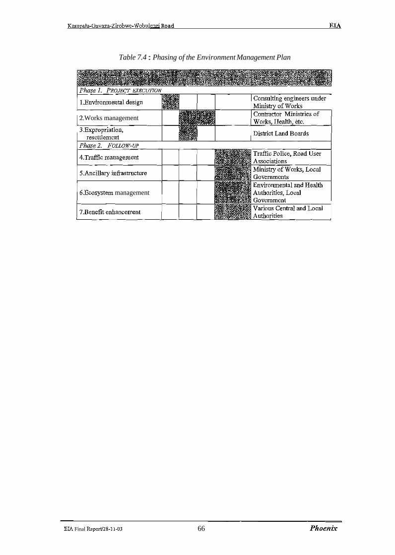
Karmala-Gavaza-Zirobwe-Wobulenzi Road EL4
Table 7.4 : Phasing of the Environment Management Plan
Contractor Ministrie .Works management
6.Ecosystem management
EIA Final Reportl28-11-03 66 Phoenix

Kampala-Gavaza-Zirobwe-Wobulenzi Road E M
8 DISPLACEMENT AND INVOLUNTARY SETTLEMENT
8.1 Main Characteristics of Settlements along the Project Road
Along the paved section (14 km), most buildings close to the road are used for commercial purposes like shops, guesthouses, restaurants, kiosks, groceries and bars. Some buildings host community services, grain milling machines, garages and various workshops. As mentioned in Section 7, this section is considered urban and peri-urban road and will not be affected by any displacement since the new road structure will follow the existing alignment. Along the rural section (53 km of gravel road), houses, surrounded by crops, are located on both sides of the road. Most of the houses are made with locally produced building materials: 75% are of burnt bricks for foundations and walls and corrugated iron sheets for roofmg. 20% are made of raw bricks or mud-and-poles for walls, but just few with grass thatching for roofs. Village trading centres and small open air markets are located at the major road junctions. School buildings and playgrounds are also found near the road as well as places of worship.
8.1.1 Expected impacts
8.1.2 Impact on land and cropped area
Most of the upgraded road in the Alignment B option will follow the existing alignment except where realignments have been introduced which will entail additional acquisition of land, displacements of homesteads and cropltrees cutting. Table 8.1 shows the quantity of land taken up by the road assuming the existing RRA width of 30 meters related to Alignment Option B (minor realignments). The 14 km paved section is not included, since no resettlement impacts have been spotted along this section of road, except one minor case.
Table 8.1: Land taken up by the project road
Concerning the present occupation of the RRA by crops and tree plantations, a widespread incompliance with present regulations has been observed. The rural sections of the road have an average width of about 15 meters including side drains and irregular berms, beyond this limit areas are fairly intensively cropped. Assuming that along 45 km of the rural sections of the road an average strip of 7.5 meters on both sides of the road is occupied by small-scale farms with mixed cropping (mainly banana and coffee trees), the total cropped area encompassed in the road reserve area accounts for about 67.5 Ha.
Optirnised alignment
EIA Final Report.128-11-03 67 Phoenix
* 30 meters width of Road Reserve Area according to the Uganda Road Act Source: Field Survey
52.7 158.1

Karmala-Gavaza-Zirobwe-Wobulenzi Road EIA
Photo 8.1 : Gayaza-Zirobwe Road. Coffee and banana trees growing on the road sides. Farming activities in the road reserve may also negatively affect the road draingage system.
The impact on land and cropped area caused by the foreseen RRA of deviations stretches is detailed in Table 8.2.
Table 8.2 : RRA impact on land and cropped area by deviation
I Deviation no 1 1 2399 1 7 2 I 1.5 1
Source: Consultant' survey
Deviation no 2
Deviation no 3
8.1.3 Impact on constructions
The constructions (all detached homes) encompassed in the RRA have been divi~ded in two groups:
constructions in the reserve area along the existing alignment sections of Alignment B, constructions in the reserve area along the realignment sections of Alignmenlt B.
121 1
6564
Table 8.3 on the following page displays the number of constructions located within the reserve area of the existing and maintained alignment as well as those encompassed in the reserve area determined by the minor realignments.
EL4 Final ReportI28-11-03 6 8 Phoenix
3.6
19.7
2.6
11.8

Kampala-Gavaza-Zirobwe-Wobulenzi Road EIA
Table 8.3 : Constructions encompassed in the RRA -Alignment Option B
5.800 1 Kumanboga 7.100 1 Kumanboga 1 30 1
EL4 Final ReportJ28-11-03 69 Phoenix
Kampala-Gayaza-Zirobwe-Wobulenzi Road EIA
Source: Field survey
From the table, the number of constructions laying within the RRA results to be : 36 homesteads 8 shops 120 m fence walls 7 latrines 1 gateway (Bugema University Campus) 1 abandoned coffee factory
8.2 Recommended Mitigation Measures
Displacement and croptrees cutting issues will be addressed during the project implementation phase, giving timely notice to owners and carrying out the coatpensation procedure before the works are over. At least equal standards of living shall be ensured. The process will be co-ordinated by the District Land Boards.
. As mentioned in the general approach to involuntary settlement issues the Consultant - recommends that the following principles are applied:
Expropriation of land, crops and trees cutting is limited to crops and trees encroaching on the road structure6 including maintenance berms; trees cutting is also a~drnitted to the ones located beyond the above mentioned area when they severely co,mpromise road safety.
Demolition of constructions is limited to the constructions encroaching on the road structure including maintenance berms, or severely compromising road safety; all other existing constructions not encroaching with the road will be allowed to remain in place, and after gazetting of the road reserve the construction of new buildings will be prohibited.
Taking into consideration the mentioned principles, on the existing road alignment (15m width) only a strip on an average four meters large is needed on each side of the road, while for minor realignments and deviations an average 23 meters of width are required for the road structure. Using the above parameters, the extra land required bythe project road structuire, for the optimised and with deviations alternatives, is 44.00 ha and 66,62 ha, respectively.
The road widening will interest about 47,9 km of the existing alignment, out of which 39.25 km are flanked with cropped areas, mainly banana and coffee plots. During the sample survey carried out on a number of sections of the existing road, an average of 36 economic valuable trees were counted per 100 metres of cropped. roadside. This means that for the optimised alternative, 14,140 trees shall be cut for widening of the existing road. For the road including deviations, the number of cut trees will reduce to l0,l so.
For the smoothening of curves and rectification of kinks, the optirnised alternative will require the destruction of 4.32 ha of cropped area, while for the alternative with deviations the cropped area that shall be destroyed is much higher (26.00 ha).
The road structure is intended as the carriageway, shoulders, embankment slopes, drains and ~rnaintenance berms. The width of the road structure varies according to a number of factors; e.g. the road structure width of a class I1 road with shoulders of 1.5 m, the embankment height of Im, side drains of 3m and maintenance berms of 2m, accounts for 23m.
EIA Final ReportI28-11-03 7 0 Phoenrjc
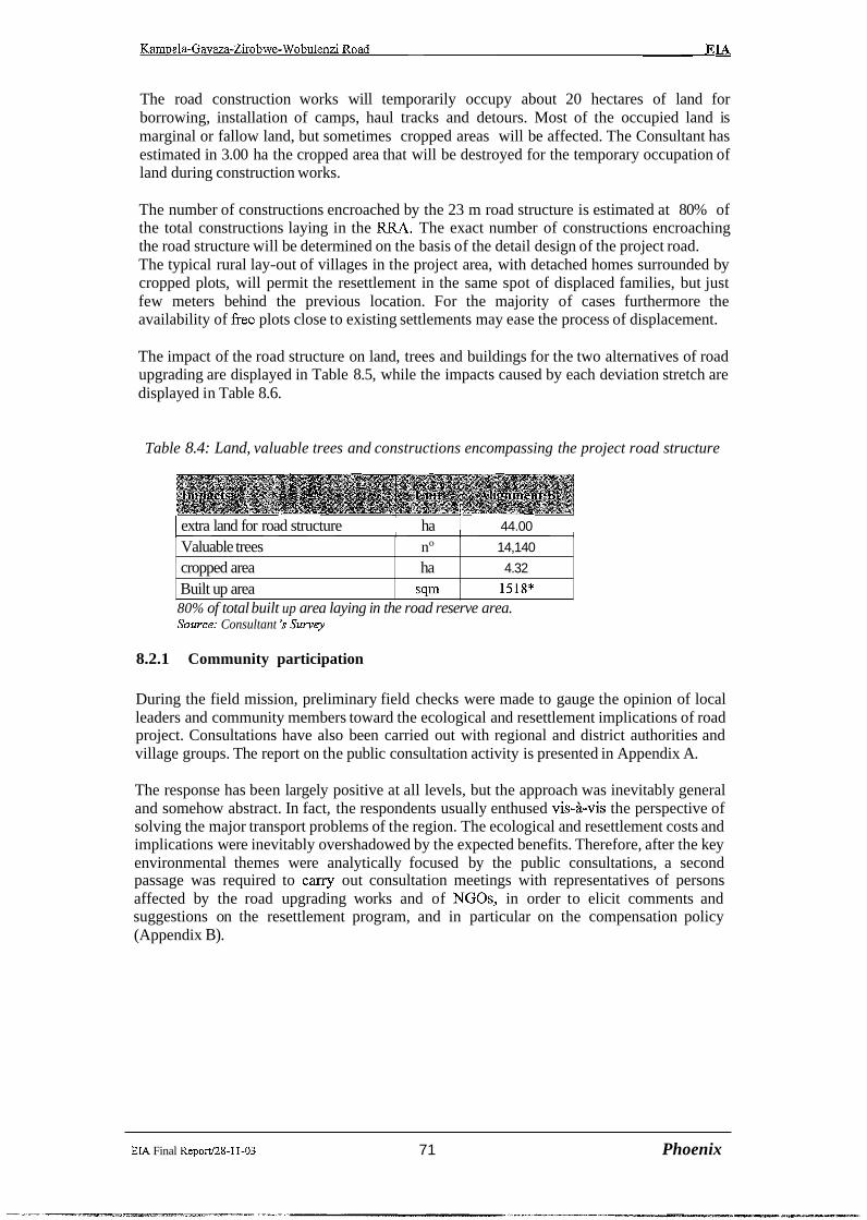
The road construction works will temporarily occupy about 20 hectares of land for borrowing, installation of camps, haul tracks and detours. Most of the occupied land is marginal or fallow land, but sometimes cropped areas will be affected. The Consultant has estimated in 3.00 ha the cropped area that will be destroyed for the temporary occupation of land during construction works.
The number of constructions encroached by the 23 m road structure is estimated at 80% of the total constructions laying in the RRA. The exact number of constructions encroaching the road structure will be determined on the basis of the detail design of the project road. The typical rural lay-out of villages in the project area, with detached homes surrounded by cropped plots, will permit the resettlement in the same spot of displaced families, but just few meters behind the previous location. For the majority of cases furthermore the availability of fiee plots close to existing settlements may ease the process of displacement.
The impact of the road structure on land, trees and buildings for the two alternatives of road upgrading are displayed in Table 8.5, while the impacts caused by each deviation stretch are displayed in Table 8.6.
Table 8.4: Land, valuable trees and constructions encompassing the project road structure
1 extra land for road structure I ha 1 44.00 1
source.. Consultant $survey
Valuable trees cropped area Built up area
8.2.1 Community participation
During the field mission, preliminary field checks were made to gauge the opinion of local leaders and community members toward the ecological and resettlement implications of road project. Consultations have also been carried out with regional and district authorities and village groups. The report on the public consultation activity is presented in Appendix A.
80% of total built up area laying in the road reserve area.
no
ha
sqm
The response has been largely positive at all levels, but the approach was inevitably general and somehow abstract. In fact, the respondents usually enthused vis-i-vis the perspective of solving the major transport problems of the region. The ecological and resettlement costs and implications were inevitably overshadowed by the expected benefits. Therefore, after the key environmental themes were analytically focused by the public consultations, a second passage was required to carry out consultation meetings with representatives of persons affected by the road upgrading works and of NGOs, in order to elicit comments and suggestions on the resettlement program, and in particular on the compensation policy (Appendix B).
14,140
4.32
1518*
EIA Final Reportl28-11-03 71 Phoenix
Kampala-Gavaza-Zirobwe-Wobulenzi Road EL4
9 RESETTLEMENT IMPACT ASSESSMENT
9.1 Objective of the Resettlement Impact Assessment
The objective of the Resettlement Impact Assessment was to provide for the resettlement and rehabilitation of Project Affected Persons (PAPS) so that their losses would be compensated and their standards of living would be improved or at least restored to the pre-project levels along the Kampala -Gayaza-Zirobwe and Zirobwe -Wobulenzi alignments.
To achieve this objective the resettlement impact assessment provided rehabilitation measures so that the income earning potential of individuals are restored to sustain their livelihoods. The specific aims of the Resettlement Impact Assessment was:
To identify persons (individuals or groups) who are affected by the Project either by the necessary destruction of existing buildings, constructions or crops, or by the need to acquire land;
To identify, through consultation, appropriate options for resettlement and compensation of project affected persons (PAPS), which accord with the legal requirements of Uganda Law and are consistent with the relevant policies of MOWH&C/RAFU and the World Bank; and
To determine a process for the successful and timely implementation of resettlement, compensation and' land acquisition, consistent with the Project objectives.
Principles
A. Resettlement planning should be based on the property indexes and conmpensation standards to improve, or at least the original production and living conditions of the resettlers.
B. The resettlement of the project shall be combined with the regional experience in resettlement matters, resource development, and economic development and environment management plans and protection. Considering the actual c;onditions, Practical and feasible measures shall be worked out for restoring and developing the production and living of the resettlers case by case, meanwhile, some necessary conditions shall be created for self-development of the resettlers.
C. Planning should be based on the principle " Beneficial to the production and make the life convenient".
9.1.1 The Project Impact in respect to resettlement:
The Proposed road development for the Kampala Gayaza-Wobulenzi road is about 67.4 Krn and basically follows the existing alignment. The recommended alignment serves moderate and relatively high population density. The project road connects several rural townships and trading centres. The Horizontal profile closely follows the existing centerline. The alignment is divided into 2 sections. * Kampala - Gayaza -Bugema - Zirobwe which is 44 Kms.Zirobwe - Nanawojja - Narnpunge - *Bamunanika - Wobulenzi which is 23.4 - Krns.
EIA Final Report128-11-03 72 PhoenIjc
The project alignments therefore serves the population and districts of Kampala, Luweero, Wakiso, Nakasongola and Mukono. The development of the alignment will highly transform development and enable communities to tap the existing and potential resources for meanina l development. The proposed project road will therefore effect some considerable impact on the population in the Direct impact zones.
9.1.3 Cutting of economic valuable trees
The banana tree (matoke) is the most common tree in the project area and for local farmers is both staple food and an income generating product. The economic value of a mature banana clump, producing about five stems per year sustains the household in food security matters. For mature coffee trees, appropriate to be extended to all trees that shall be cut for road widening. The present survey has estimated at 14,140 the total number of trees that to be cut during the works. Loss of such valuable trees and crops was realised during cadastral surveys and
construction. Project activities will considerably affect the farming potential along the right of way.
9.1.4 Loss of agricultural production
During the road upgrading works, an estimated area o f 3 hectares of cultivated land will be temporarily taken up for camp sites, borrow pits, quarries, service roads, an estimation of accidental construction damage and detours.Adding this area with the cropped area expropriate for road realignments (4,32 ha), the total cropped area that will be destroyed by the road works will amount at about 7,32 hectares. The preliminary surveys indicated that farmers grow a lot of perennial trees, mainly bananas and coffee intercropped with a large amount of other crops, like cassava and sweet potatoes. The value will be determined during property valuation by the Chief Government Valuer.
9.1.5 Displacement of stalls and demolition of Houses
During the preliminary surveys, more than 100 market stalls and kiosks, mainly located along the paved road section, were identified as encroaching onto the upgraded road structure. The project was obliged to compensate such structures and houses that are with in right of way. It provided replacement land acceptable to the project-affected persons and ensured that all PAPS were assisted in both reconstructing their homes or premises and relocating.
9.1.6 Institutions and Organizations
From the field studies and consultation with the communities, it was realisesd that the impact on institutions was not there and as such that no Institution was relocated. Cultural Institutions
In this category no cultural Institution facility was relocated. However considerable number of commercial establishment shops, kiosks and lock-ups will be relocated. Special measures were taken to minimize the demolition and total relocation and if possible, the influence of demolition of such facilities as the impact extends to people using the facilities.
- - -
EL4 Final Reporti28-11-03 73 Phoenix

Kampala-Gavaza-Zirobwe-Wobulenzi Road EIA
If deemed necessary by the PAPS in their new locations similar facilities for the co~mmunities will be set -up after close consultation with the affected communities. The business aspects of the facilities will be compensated in form of the disturbance allowance provided for by the Land Act of (1998) of the Republic of Uganda. Crops, Trees, Agriculture farm and vacant Land will be computed to Units at replacement Cost.
9.1.7 Public Utilities and Infrastructure
All public Utilities and Infrastructure would be restored to the original senrice scale. Communication power and water supply will be adjusted and restored to non-PAPS in the area before demolition of designated structures. The relevant utility companies under close collaboration were to under take drainage facilities for the affected areas most especially Kampala- Gayaza and Wobulenzi would be reconstructed in the process of road construction by the project work on public utilities with the contractor and project supervisor.
9.1.8 Land Acquisition
Land acquisition of farmland will be required for widening of some sectio:ns on the alignment land will acquired during land cuts, fills, borrow pits and contractors labor camps. In some Instances Land acquisition will affect the loss of some agriculture land and crops; All property loss of the affected rural production teams will have to be compensated.
9.2 Infrastructure and Social Improvement
In the selection of design options for the road upgrading, the existing social and c~ommercial entity of communities along the corridor were taken into account. For instance, at Bulami and Janda, options to bypass these communities were rejected because such opti~ons would sever the communities from their principle trading market and thus adversely effect the fabric and integrity of the village commercial and social environment. Because such decisions have been made in the feasibility design process, the project works are not expected to adversely affect the existing infrastructure and social systerns within communities along the project route.
Over the length of the project, relatively few people are affected by the works and require relocation, but nevertheless, compensation must be set so that affected persons are not disadvantaged compared to others and can accrue the benefits realised by the road upgrade.
9.3 Consultation and participation of the population in the resettlement Activities
The affected people and leaders in the project-impacted area are being consulted and encouraged to participate in all the process of the resettlement. During Environment and social impact assessment studies on the project road, communities along the project road and corridor at large (opinion leaders + key stake holders) were consulted and informed1 about the project at an early stage. They have/ will participate in census surveys, socio Economic studies, land and property valuation, identification of all the project affected persons. More so, their participation in Monitoring and Evaluation of the resettlement exercise is indispensable. In summary the affected persons will participate in
Information dissemination and community meetings Grievance off~ce set -up Identification of property affected persons. Land and property valuation Resettlement consultation process.
- -
EIA Final Report128-11-03 74 Phoenljc
Identification of problems and solutions that may emanate from resettlement exercise among others.
9.4 Institutional Arrangement
Ministries of works, Housing and Communication, Justice and RAFU together with the District Land Boards are key Institutions responsibilities for the resettlement exercise. Together they will follow the Constitution of the Republic of Uganda (1998), the Land Act 1998, the Town and country Planning Act 1964 and Land Acquisition framework produced by RAFU (2001). RAFU and MOWHC will have to put in place a commendable experienced team for the resettlement process. Co-ordination while undertaking the task is called for. The local leaders, landlords, cultural heads, District Land Boards, Ministry of Lands Water, Environment and chief government valuer's ofice have been involved in one way or another for instance in the following activities *:+ Identification of PAPS and lawful landholders Q Property verification and Valuation *:* Issuance of New Land Titles *:+ Compensation and restoration of livelihood of the affected persons *:* Evaluation of the key activities undertaken during the resettlement process.
9.4.1 Sites Affected by the Project
Essentially the Project involves widening the existing road structure over the entire length of the project road and, at various locations, to either straighten or otherwise improve the horizontal alignment of the road, raise the road level over swamp areas and improve the road gradient by cutting (lowering) high points.
For most of the length of the project road, the road construction will be within the corridor of the existing nominal road reserve, which is defined in the Roads Act of 1964 as being that area bounded by imaginary lines parallel to and not more than fifty feet (15 m) distant from the centreline of any road. On arable ground, the land within this road reservation which is not occupied by the existing road is typically cultivated and cropped. The road construction works will affect these crops, but not necessarily to the full width of the road reserve.
At some locations where the upgraded road alignment departs from the existing alignment, the roadworks will extend outside the width of the existing road reserve. At these locations, land acquisition is required in addition to crop compensation.
The main impact of the Project construction works, in the context of this report, is the destruction of crops on land required for the construction. Of lesser scale, but of no less importance, is the demolition of houses, shops, market stalls and other erections on land affected by the works. Over the length of the Project, fifty-two buildings and other permanent constructions are so affected. The degree of demolition of permanent structures is limited by the road upgrading design, which purposefully optirnised engineering criteria and resettlement/social issues.
9.4.2 Entitlement Framework
The Project implementation and construction activities will result in the displacement of people, acquisition of land and property and the destruction of crops along the alignment.
EIA Final Reportl28-11-03 75 Phoenix

Kampala-Gavaza-Zirobwe-Wobulenzi Road EIA
The impacts of these effects are measured in terms of the number of properties lost, size of property, the type of property (residential, business or commercial) and ownership of such property for' displaced affected persons (PAPs). The Resettlement Action Plim for the proposed road project will describe and enumerate the extent of negative impacts likely to be imposed on the people and their property because of construction.
The Plan will present the extent of the entitlement framework that is to be adopted to minimise then impact and compensate for losses that will be experienced by the Project Affected Persons (PAPs). These entitlements are to cover the loss of land, structures and other assets, such as crops, houses, land, stalls. The PAPs in this respect are entitled to a disturbance allowscnce (Town Planning Act 1964) and counseling on alternative assistance.
Under the Land Acquisition Act (1965) compensation for property structures and other assets such as crops that will be lost to the project are of important as far as compensation and relocation of communities is concerned. The Land Act (1998) requires compensation to be at market value. The Government Valuer will effect market value assessment of the property for affected persons. Assessment to
;. determine whether additional assistance is necessary to reach the real market value has to be put into account.
Compensation to the project affected persons (PAPs) should adequately address their losses based upon the entitlements approved by the Government of Uganda in applying the Land Act (1998) and the Town and Country Planning Act of (1964) respectively. The entitlement framework therefore comprehensively addresses all of the resettlement issues that are predicted for the Project.
The framework conforms to the legal framework of Uganda Law. In piuticular it accommodates the provisions of the followings Acts and Statutes:
The Town and Country Planning Act (1 964) The National Environment Management Statute (1 995) The Land Act (1 998) The Decentralisation Act (1997).
9.4.3 Institutional Framework & Involvement of Local leaders
The implementation of the project will require organizational framework; that will ensure appropriate co-ordination between the implementing agency M O W H & C M J and wil utilize the MOWH&C Resettlement Framework November 2001.The LC1 will be involved in the resettlement process. They will help in identification of lawful PAPS and assist in the compensation process, in resettlement implementation and in the monitoring and evaluation of the relocation process. Their responsibilities during the resettlement period will include; assistance in the identification of the actual affected persons and in the moioitoring of resettlement activity, amongst other responsibilities.
There is a need to establish an independent grievance committees through which the project affected persons could channel their complaints in case there is need to do so. Tht: grievance committee will comprise of the following
RAFU-To explain technical matters to the affected persons and local councils during the meetings
- - -
EIA Final ReportJ28-11-03 7 6 Phoenix

Chief Administration Officer (CA0)-Role is to monitor the progress on the implementation of the programme on behalf of the Government possible through the Assistant Chief Administration Officer in Charge of land matters District land Officer-technical issues on land management and administration Local Council Chairperson- to ascertain ownership within the affected areas.
All the committee have the same voting rights. The committee should be established and start work before the relocation excise starts.
9.4.4 Implementation strategies of the plan
Consultation Strategy:
A key strategy for the RAP implementation activities to be effective is for collaboration both in the vertical and horizontal levels between communities and Government representatives on one hand and between Local Government Councilors and Government Ministries (Justice, MOWHC and Lands, Water and Natural Resources) on the other. Cross sectional linkages to enhance co-ordination, enabling a sharing of experiences that will permit the RAP process will have to be consolidated.
To effect the Resettlement Action Plan, RAFU will form a Resettlement Implementation Team . This Team will be charged with forming, in association with Local councilors, various stakeholders representing PAPS in communities along the road. Each committee will include the LC1 chairperson, registered landlords of affected properties (or representatives), community elders and representatives of NGO's operating at community level. The Resettlement Implementation Team (RIT) will identify the land which will be affected by the project works and it is the function of RAFU in collaboration with the local leaders to identify Affected Persons and represent their interests in determining an agreed compensation and resettlement solution.
Consolidation of Monitoring and Evaluation Systems with Stakeholders
Monitoring and purposeful evaluation are key factors in implementing successful resettlement activities and it is also important to note that different stakeholders have different interest in the project outcomes. The work of the RIT and committees will effect participatory representation, monitoring and evaluation within the affected communities, with indicators designed by the community and leaders of the affected communities. This will help to determine the effective level of progress. The justification for the collaboration is that, all interested stakeholders will attain a significant participation and thus ensure the success of the project.
Involvement of NGOs and CBOs
A number of NGOs and CBOs are currently working in the project corridor on integrated development activities. The Consultant has interacted with a number of them during social and Environment Impact assessment field studies and they have showed a willingness to participate with Government and local leaders in relocation process. NGOs that have shown interests in resettlement activities include Plan International, World Vision, Buso Foundation, Uganda Women Credit Finance and the Catholic parishes of Natyole and Zirobwe. These institutions are community based and understand the communities they work among. They will be involved, along with Local Councilors, in resettlement implementation activities.
EIA Final Repod28-11-03 77 Phoenix

Kampala-Gayma-Zirobwe-Wobulenzi Road EM -
Notzfication:
Formal notification of the affected people about the project should be done as !part of the ongoing public consultation. Several steps should be considered to make sure that the aFfected population is properly informed.
Distribution of information and explanations to Local and District Authorities in the form of an information leaflet, outlining the major characteristics of the project and a general schedule or at least a chronology of events. Information brochures that will be distributed to village leaders will also be distributed to villagers at the community meetings The legal requirements of publication of the intent to acquire will be published in the Uganda gazette and displayed along the project road.
Follow-up meetings should then be held with District Authorities and with local leaders, including the Local Councils and Communities, which have overall responsibility for co-ordination.
Open meetings in which the project is presented to the general population
This notification procedure sets the scene for the registration and detailed recording of assets. These registration details will supplement the information in the socio-economic survey carried out by the FUT. Information from that survey should be used to cross;-check the claims and details recorded at the time of registration.
Compensation will be conducted within the legal fi-amework of Uganda Law. Tr,ansparency will be maintained in all aspects of the property valuation and compensation. These are the following aspects of transparency that need to be adhered to:
The list of Entitled Persons (EPs) shall be displayed, as a minimum, in areas accessible for all the EPs and other PAPs. These public places should preferably be LC Offices. The entitlement framework for the replacement value will be communicated to all EPs and will be explained to the EPs and others in village meetings organised by tlhe RTT and the hired consultant. Disbursement of all payments due to the PAPs is to be made in public meetings only. A quarterly report on implementation of the RAP, which may be delineated as per District boundary and which must contain details of "assistance" compensation will be similarly displayed. A quarterly report on the grievance procedure and the final award in all cases of grievances will also be displayed in the same public places (specifically mentioning the same name of the EP and the difference in awards before and after the grievance hearing).
All decisions regarding individual/group/community entitlements and the contents of all decision shall be made public.
Payment of compensation and assistance will take place during public meetings with all the other EPs of the area included, and will be witnessed by the committeed groups formed for the resettlement implementation and the LCs relevant to particular sections of the Project. Members of the Grievance Committee may also be present.
The RAP will include a time schedule, which anticipates that all PAPS will be co~mpensated and relocated before the scheduled end of the resettlement period, March 2003. This is five months prior to the scheduled commencement of the physical works.
- -
EIA Final ReporV28-11-03 7 8 Phoenix

Kampala-Gavaza-Zirobwe-Wobulenzi Road EIA
Inventoly of Affected Properties and Persons:
An inventory of affected properties and registration of affected persons was prepared. The registration procedure for affected properties and persons consisted of formal notification to the affected people and the establishment of so-called "cut-off date" and the "actual" registration of the affected persons.
A grievance committee that will be established for the purpose of resettlement implementation and scrutinising the interests of the affected people informed about the registration. The committee should include members of the LC for the respective villages, village elders, representatives of registered local property owners and landlords members of the District land Boards and voluntary development organisations. The registration process is intended to involve different parties in different villages in the resettlement/compensation process to avoid disputes or misunderstanding at a later date. Registration form should be prepared to ease the task.
The registration form could include the following elements:
Household information: means and details about each member, including economic activities and number of dependants outside the village Relocation information about present situation and preferences List of f ~ e d assets including buildings, permanent gardens, wells and other water sources. If any Identification of possible factors that would place a particular household under the category of ccvulnerable" such as the number of dependants, single parent, female household head, lack of ample land or income, etc.
A complete form will be developed by the Consultant and should be agreed to by RAFU in co-operation with other Government authorities and assistance of legal experts.
This registration could supplement the information that will be obtained during socio- economic survey. Data from that survey should be used to cross-check the claims and information at the time of registration since most, if not all, of the households in the Direct Impact Zone have been recorded during the earlier Environment Impact Assessment carried out as part of the Project Feasibility Study. There could be a risk that some of the people may be tired of being asked the same sort of questions, but it should be reiterated that the registration is absolutely necessary for a fair compensation and successful relocation of families.
Registration and the recording of assets should occur directly after notification of the cut-off date and the general information meeting at the various villages in the Direct Impact Zone. One should use this meeting to explain why the registration is taking place.
The cut-off date is difficult to establish in any road project that involves resettlement and compensation for loss of land, especially in regions where there are no land documents. The danger with this type of project is that speculators will take advantage of local people and grab land.
Experience shows that any retrospective dates are problematic. It is better to choose a date that is close enough to the proposed project start date such that the situation on the ground
EIA Final Reportl28-11-03 79 Phoenix

Kamuala-Gavaza-Zirobwe-Wobulenzi Road EL4
will not be seriously altered in the interim period. Deciding on the cut- off date will be the responsibility of RAFU and the Government in co-operation with the Solicitor-General. Once the date is agreed upon, the affected peoples should be informed immediatel:~. Timing is important so as to avoid speculators. This can be done as part of the formal notification. The principle is that all people who are resident on the land on that day will be entitled to resettlement and compensation. The registration and record of assets will be conducted immediately after notification.
Flexibility and Contingency Management
RAFU will identifl the risks and benefits associated with each option of entitlement policy. Contingency plans and a flexible programme of implementation will ensure that PAPS are not disadvantaged by the project by unforeseen circumstances. The contingency plan and any other addition/alteration/modification to the resettlement plan for the project will need to be endorsed by the Resettlement implementation Team to be effective.
Resettlemenf and Compensation
Two of the most important aspects of the Resettlement Action Plan are resettlement of affected persons and compensation to entitled persons for loss of property, land and crops, either temporary or permanent. It is essential that compensation and resettlement be handled promptly and fairly since many will judge the success of other mitigation measures by how these two issues are handled.
Whilst the resettlement and compensation measures are based on the World Bank" OP 4.12 on Resettlement, they aim to exceed these guidelines and provide the populi3tion with improvement to the existing situation, not merely a re-establishment of existing levels that reflect a very low standard of living (NTEC 1988). This is necessary if affected ptersons are to be in a position to realise the overall benefits of the F'roject. Compensation and resettlement in respect to the project road will concern individual households and owners of fields, which are located in the Direct Impact ZoneICorridor.
Resettlement Options
In a review of procedures and policies (WB 1994b), the World Bank acknowledged a link between displacing people and restoring their property without affecting their livelihood (Scudder & Coision 1982). It is therefore strongly recommended that in the resettlement process emphasis be placed on establishing new households in viable areas within their existing community and preferably within the vicinity of their original plots and neighborhood.
Although affected persons could be encouraged to pursue resettlement in line with the above recommendation, there are a number of options available to those who will have to be relocated. The following options are based on out-come of interviews with PAPS about compensation and resettlement.
Land for land within the area -some could prefer this option since it would allow them to remain in the same communities and also benefit from the expected social improvements by the project. This option would involve purchasing or acquiring land within the communities and arranging matters with the LCIs.
Cash for land - some people could prefer cash.
Relocation in another part of the District where they had relatives to help them get started.
EM Final Reportl28-11-03 8 0 Phoenix

Kampala-Gavaza-Zirobwe-Wobulenzi Road EIA
However cash payment may generate some problems. Experience from other resettlement schemes within the project Districts, as well as general experience with resettlement, has shown that there is a danger that the cash will be spent quickly and the impacted family may not be able to set up house in another place without help. If families prefer this option, there should be an agreement on the purchasing of land elsewhere and co-operation with District Authorities. In other words, there should not merely be a handing over of a lump sum.
9.4.5 Payment for the lost property and Transparency
The estimated budget cost for Resettlement Action Plan implementation for the project is as shown in the table below and based on projections but will be conclusively ascertained after property valuation and actual preparation of the resettlement plan.
Budget Costs
1 Land 1 58,269,639
I Crops 1 34,356.680
Structures
I Total before 15% Disturbance 372,373,478
279,747,159
Property valuation will be conducted by the Chief Government Valuer's office who will report to RAFU but co-ordinate with the Resettlement Implementation team (RIT and the grievance committees to be established along the route for the purpose of resettlement implementation. The Consultant will identify the properties afFected and the local leaders will assist in identifying the bona Jidellawful property owners to be compensated. If a household asset is to be taken, compensation should be given to the legal titleholder but if compensation is in form of a parcel of land or a structure, the registration will be in names of the title holder, hisher spouse or children. Compensation will be conducted within the legal framework of Uganda Law.
Transparency should be maintained in all aspects of the property valuation and compensation. These are the following aspects of transparency that need to be adhered to:
The list of PAPs shall be displayed, as a minimum, in areas accessible for all the PAPs. These public places should preferably be LC Ofices. The entitlement framework for the replacement value will be communicated to all PAPs and will be explained to them in village meetings organised by the RAFU and the Consultant.
EIA Final ReportI28-11-03 8 1 Phoenix

Kampala-Gavaza-Zirobwe-Wobulenzi Road EIA
Disbursement of all payments due to the PAPS is to be made in public meetings only. A quarterly report on implementation of the RAP, which may be delineated as per District boundary and which must contain details of "assistance" compensation will be similarly displayed. A quarterly report on the grievance procedure and the fmal award in al:l cases of grievances will also be displayed in the same public places (specifically mentioning the same name of the PAP and the difference in awards before and after the grievance hearing).
All decisions regarding individual/group/community entitlements and the contents of all decision shall be made public.
Payment of compensation and assistance will take place during public meetings with all the other PAPs of the area included, and will be witnessed by the CBO groups formed for the resettlement implementation and the LCs relevant to particular sections of the Project. Members of the Grievance Committee may also be present. Grievance centers for registration of grievances should be established at Sub-couinty offices at ~ i r a , ~ a n ~ a m b o , Busukuma, Kalagala, Zirobwe, Bamunanika, Katikamu and 'Wobulenzi Town Council.
Participation of Chief Government Valuer in the Resettlement Activity
The Chief Government Valuer is the Government person identified to determine tlie value of property and land and the level of compensation for all the aec t ed persons along; the route. The CGV will report to RAFU and will need to be involved early in the resettlement process to ensure that valuations are determined in time to allow the payment and grievance procedures to proceed.
firzplementation~Responsibilities and Procedure:
RAFU are responsible for implementation of the RAP as part of the road upgra~de project. Through the project, the GoU will technically and financially assist PAPs with a rebuilding of their lives, livelihoods and social and economic networks. The RAP is a development package, not simply a welfare solution. It encourages PAPs to help themselves, by enabling them to actively participate in the selection of an appropriate compensation and assistance options.
RAFUYs function will be to implement and monitor the RAP and its associated activities. This will be accomplished by RAFU and the Consultant whose functions are to include:
identification and marking of land to be acquired and properties affected by thle works; determination of legal title and ownership of affected properties; preparation of an inventory of affected properties; survey of baseline socio-economic conditions; formation of committees for the purpose of resettlement implementation, as necessary along the route; organisation of meetings with CBOs as necessary to effect resettlement.
The Consultant will need to put in place the following personnel:
A Sociologist with responsibility to establish grievance committees, undertake community meetings and consultations, source for survey baseline information, organise meetings with the CBOs, PAPs and local leaders, promote and report re'settlement
-
EIA Final ReportJ28-11-03 82 Phoenix
progress including identification of social developments during implementation and potential grievances;
A Surveyor to undertake cadastral surveys, land surveying and marking of the centreline of the designed road upgrade for resettlement purposes. There will also be need to assist the affected persons with getting the new land Titles.
A socio-economic survey of the PAPs is to be conducted. The objectives of the survey is to gather all requisite baseline information about likely PAPs, namely:
To attach actual values to key indicators of the PAPs social and economic status and their vulnerability to social and economic changes as a result of the project; and,
To provide a benchmark for further information needed to monitor and evaluate EPs in the future.
9.4.6 Monitoring and Mitigation Measures
The objectives of monitoring the RAP activities of the project are to provide RAFU with an effective tool for assessing resettlement progress, identifying potential difficulties and problem areas, and providing an early warning system for areas, which may need correcting. Some of the risks associated with resettlement include impoverishment, malnutrition, increased morbidity, and dependency; break down of community norms and mutual support systems. Monitoring can be carried out specialised groups who will report to the M U .
Ongoing evaluation should address complex social, cultural and economic issues. Monitoring should assess in particular the situation of the vulnerable groups such as small and marginal landholders, unskilled laborers, mobile vendors, tribal populations, ethnic minorities, women, children, and the elderly and disabled persons.
Baseline survey data is necessary to provide the benchmark for measuring and evaluating the success of the RAP. There is one reason for the completion of the socio-economic surveys by the Implementation team prior to resettlement implementation.
Monitoring will cover the physical progress of the resettlement site including preparation of land, construction of houses, construction of facilities, provision of infrastructure and other necessities. The monitoring should also cover the relocation of people and their goods to the new sites as well as the allocation of replacement assets. The consultant and RAFU will ensure that the PAPS take active part in process of their rehabilitation. Independent monitoring agency will observe the functioning of the resettlement Network including adjustment of the PAPS to their New locations and compensation of the affected property. Monitoring reports will be submitted to M U , World Bank reports Government of Uganda.
For buildings needing to be demolished, the registration form will include the following elements:
Household information: means and details about each member, including economic activities and number of dependants outside the village; Relocation information about present situation and preferences; List of fixed assets including buildings, permanent gardens, wells and other water sources;
EIA Final Report128-11-03 83 Phoenix
wala-Gayaza-Zirobwe-Wobulenzi Road EIA
Identification of possible factors which would place a particular household under the category of "vulnerable" such as the number of dependants, single parent, female household head, lack of ample land or income, etc.
9.5 Reporting Arrangements
The RAFU will be responsible for monitoring the project. A performance standard will need to be developed to monitor the project at both the District and project level. Quarterly reports should be received from those in the Districts and fed to the RAFU who will be responsible for the project level monitoring.
Monitoring and evaluation should continue for several years after the reloc.ation and compensation of the project affected persons, but at less frequent intervals, for example annually. The benchmarks during the socio-economic surveys of the PAPS will be compared to evaluate changes in the socio-economic conditions of the PAPS.
An independent Consultant with experience in resettlement activities could be engaged to carry out the evaluation of the implementation of the resettlement and rehabilitation of the PAP. Deficiencies in the resettlement implementation shall be assessed and changes to procedures on future projects shall be recommended to ensure the problems do not occur.
Having identified and determined the situation on the ground and based on the re:actions of the consulted key stakeholders in the project corridor, the following approaches art: proposed to be used during the monitoring and evaluation of resettlement and compensation activities of all the entitled persons along the route
Reporting and field appraisals
This is to be effected from the management level (RAFU) to co-ordination in the field (RIT). Arrangements should be made regarding the reporting system to be used. The r'esponsible personnel should make all the reporting. The R E Manager should be responsible for the field reporting exercise. RAFU then should be responsible for submission of the reports to World Bank and Government Authorities. The reporting should be made bi-monthly. Periodical field activity reviews must be undertaken. These reviews should be done at field @IT) and management (RAFU) levels of the programme. The field activity reviews should report the outcomes of meetings, field visits with the local Councils, and meetings/discussions with project affected persons, families and groups. RAFU and field staff should decide upon the frequency of such meetings. The RAFU Officer-in-Charge of the programme, with the field staff, should fiom time to time visit the field to assess the situation on the ground and c o n f m progress of the resettlement activity along the route. Analysis of the information gathered from such visits could be helpful in finding in finding solutions to potential problems during the resettlement exercise.
EM Final Reportl28-11-03 84 Phoenix
Kampala-Gayaza-Zirobwe-Wobulenzi Road ETA
9.6 Resettlement Implementation and Evaluation
Resettlement implementation evaluation needs to be conducted to ensure that checks and balances are effected for the successful implementation of the project. Mid-term and end-of- activity evaluation was conducted.
EIA Final Repod28-11-03 8 5 Phoenk

Kmala-Gayaza-Zirobwe-Wobulenzi Road EIA
10 TOTAL COSTS
10.1 Cost sf Environment Management Plan: Phase 1
The present study has estimated the cost of a set of mitigation measures, which should be incorporated in final road design (Table 10.1). For the economic evaluation of the project, in Table 10.2, the costs of the environmental mitigation measures have been distributed according to six road sections (refer Section 2.1).
Table 10. 1 Cost of environmental mitigation measures
1 hydro-broat;t of seeds 1 s q q 1 ::11 1 and ve eta1 turf
Re-filling of borrow pits 1 c ~ ~ ~ ~ ~ ~ ~ ~ ~ u l 1 I 1 2,000,000 1 19.6 1 39,200,000 1 roads and detours
1,5 m of width extra- shoulders in village 52500 4800 251,900,000,
( crossings I I ,I
I Bus bays 1 sqm 1 17500 1) 4200 73,400,000(~
Source: Consultant's estimates
EIA Final ReportI28-11-03 86 Phoenix

Kampala-Gavaza-Zirobwe-Wobulenzi Road EIA
Table 10.2: Cost of environmental mitigation measures by section ofproject road and alignment alternative
( U S million)
Road 11 12 3 14 15
Stabilization of cuts with hydro- broadcast of seeds and vegetal turf -
Re-filling of borrow pits
Restore 10.7 1 vegetation
borrow pits, haul roads
width extra- shoulders in village
Bus bays I crossings
Road signs & road humps
-
EIA Final Reportl28-I 1-03 87 Phoenix
Total (USh
-
9.45
21.00 3 1.50
21.6 163.1 187.5 244.6

Kam~ala-Gayaza-Zirobwe-Wobulenzi Road EIA
10.2 Resettlement Costs
The Feasibility Study has quantified the approximate physical and economic impact of resettlement, as tabulated below (Table 10.3 below). For the economic evaluation of the project, in Table 10.4 (following page), the resettlement costs have been distributed according to six project road sections.
Detailed field checks during the final design stage will assist in speeding up the compensation procedure.
Table 10.3: Resettlement components: size and cost
* the unit cost includes compensation for detached home facilities and services and possible dislocation of family graves. Disturbance allowance also is included.
** The small paper factory encompassing the deviation nOl is not included. Source: Consultant's estimates.
EIA Final Report128-11-03 88 phoenix
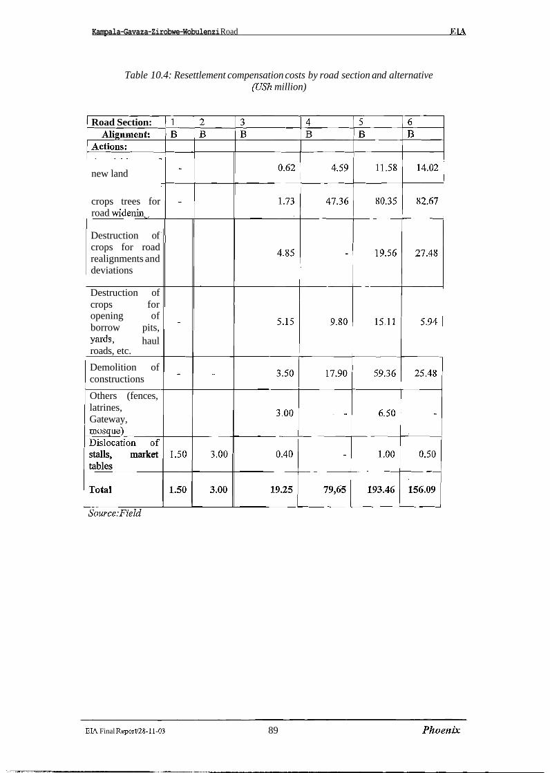
Kampala-Gavaza-Zirobwe-Wobulenzi Road EL4
Table 10.4: Resettlement compensation costs by road section and alternative (UYh million)
1 Road Section:
new land
crops trees for road widenin
Destruction of crops for road realignments and deviations
1 Destruction of crops for opening of borrow pits, yards, haul roads, etc.
Demolition of constructions
Others (fences, latrines, Gateway, mos ue) b stalls, market tables C
EIA Final Report/28-11-03 89 Phoenljr
Kampala-Gavaza-Zirobwe-Wobulenzi Road EIA
10.3 Total Cost of the Environment Management Plan and Resettlement
Environmental/social mitigation and enhancement measures - including resettllement and remedial works to offset construction damages and post-construction impacts of road use Alignment B -is approximately from USh 1,339.4 million Additional costs for ancillary infrastructure and other follow-up interventions will be borne by the central antd regional administrations, with the participatory effort of local urban and rural communities.
The cost for mitigation measures is substantially higher than the cost for resettlement and compensations, mainly due to the important mitigation works during the constructtion stage. In average the proportion between the above costs is 63% for mitigation measures and 37% for resettlement.
The incidence of mitigation measures and resettlement on total construction cost of the project road is approximately 2.9% for Alignment B
The summary of mitigation measures and resettlement cost for Alignment B is displayed in Table 10.5 overleaf.
The distribution among the six road sections of the mitigation and resettlement cost is variable. The first two sections traversing the urban area of Kampala require less important measures because the areas needed by the road widening are prevalently free of obstacles and will not be affected by construction operations such as borrow pits, haul roads; and other ancillary facilities.
The rural areas will be more affected than urban areas at both stages of road construction and utilization, as well as concerning mitigation measures and resettlement.
The cost under review per km of road in the urban area amounts to USh 7.75 milllion, while the same cost for the road sections in rural areas varies from USh 21.37 million to USh 24.5 million per krn, according to the road Alignment B. In Table 10.6 overleaf are summarized the costs of mitigation measures and resettlement by road section according to Aligpment B
EIA Final ReportI28-11-03 90 Phoenix
Kamuala-Gavaza-Zirobwe-Wobulenzi Road EL4
Table 10.5: Summary of cost for mitigation measures and resettlement
I 1. Stabilisation of cuts with hydro-
1 5. Bus bavs I 73.5 1 42.000 1
3. Restoration of vegetation in borrow pits, camps, haul roads and detours 4. Extra shoulders for pedestrians and cvclists
1 Resettlement and compensation costs
39.1
251.8
4
6. Road signs &road bumps Sub-total Alignment B
22,360
143,897
3. Crops destruction for realignments and deviations 1 51.91 29,6511
52.3 886.4
1. Additional area for road widening 2. Destruction of crop trees
29,903 506,537
1 5. Demolition of construction 1 106.2 1 60,709 1
30.8 212.1
1 4 Crops destruction for opening of bbrrow pits, yards and haul roads
6. Others (fences, latrines, gateways..) I 9.5 1 5,429 7. Dislocation of stalls. market tables 1 6.4 1 3,657
17,606 121,206
36.0 20,571 I
EIA Final Report128-11-03 91 PI20ertk
Table 10.6: Costs (US$) of mitigation measures and resettlement by road section
Kampala - Nsooba 1 5,3981 8571 6,2551 i;"'~; S.3 Mpererwe - ~ ~ ~ ~ ~ ~ ~ i ~ ~ ~ ! - - l ~ ~ - Gayaza 93,198 ----- 11,000 104,198
S.4 Gayaza - Kiwenda 107,146 45,514 152,660 S.5 Kiwenda - Zirobwe 139,777 110,549 250,326
.-p----.---...----.
k.6 Zirobwe - Wobulenzi 1 148.6221 89.1941 237.8161
EIA Final Report128-11-03 . 92 .Phoenljc
Kampala-Gavaza-Zirobwe-Wobulenzi Road EI A
11 CONCLUSION AND RECOMMENDATIONS
11.1 Conclusion
The Environmental Impact Assessment has addressed Alignment B, which has been preferred from the technical, economical and social aspects. If the project is implemented taking into account the impacts identified and the corresponding mitigation measures, the overall impact on the environment will be minimal.
On the alignment B, the highest risk will be in the area of compensation which, if not properly addressed, will lead to local discontent and possible delays in the construction. The realignment within the existing corridor, this should not however be a problem since, fi-om the results of the completed Resettlement Consultation (Appendix B); the local people are all in favour of the road development.
11.2 Recommendations
The Environment Management Plan described herein is implemented;
The budget for the Environment Management Plan identified herein is included in the cost of the project put forward for funding;
Finally it is recommended to limit the areas to be cleared from constructions and crops to the minimum indispensable for road widening.
- -
EIA Final Reportl28-I 1-03 93 Phoenix

Kampala - Gayaza - Zirobwe -Wobulenzi Road
Phoenix


Kampala - Gayaza - Zirobwe -Wobulenzi Road
Phoenix

Kampala - Gayaza - Zirobwe - Wobulenzi Road feasibilify study and detailed engineering design
1.0 Introduction
The Kampala - Gayaza - Zirobwe - Wobulenzi project is one of the classified roads for up grading.
This will involve construction of a paved ( (bitomen surface) road on the generial alignment of the
existing road will have to be widened. Where the alignment has to be improved, road construction will
affect some crops and land. Some of the materials will be obtained fiom borrow pits and the quarry sites
already in the area. Upgrading of Gayaza - Zirobwe will probably start in 2004 and will take 1-2 years
to complete.
The Zirobwe - Wobulenzi may also be upgraded similar to the Gayaza - Zirobwe depending on the
availability of resources and analysis. The Zirobwe - Gayaza road will involve imlx-oving the drainage,
widening of the shoulders and resurfacing of the road with an asphalt concrete layer. This work is
expected to start in 2004.
1.1 Description of the project area
Kampala - Gayaza - Zirobwe - Wobulenzi is located in the-North - West of Kampala and serves the
districts of Kampala, Wakiso, Luweero, Mukono, and Nakasongola. The project cuts across, Kira,
Busukuma, Bumunanika and Katikamu counties. The project area is mainly im agricultural area,
producing banana, cassava, potatoes, coffee and other plantations. It is one of the food basket for
Kampala. The project area has over 30 primary schools, Bugema University the Narnulonge Agricultural
research Institute of Makerere Unviersity, Mairye and Magigye poultry and flower projects
respectively. The project area has sounding potential for development and investment. One of the
restraints to development in the area is poor road network.
1.2 Methodology for the Public Consultation:
Consultantions were organised with a number of stakeholders along the project corridor. Consultative
meetings were conducted at Busukuma (Busukuma) and Mpigi (Kalagala and Zirobwe)
Public Consultation Report April 2001

Kampala - Gayaza - Zirobwe - Wobulenzi Road feasibility study and detailed engineering desigr?
Participants included:
> Local development leaders
> Opinion leaders ' > Teachers
> Quarry and borrow pit owners
> Community development leaders
> Personnel from NGOs and CBOs working in the area.
> Government officials
> Local leaders
> Landlords and residents along the alignment
Consultation meeting elucidated the current development potential of the project corridor. Impact of the
project at the pre-construction, construction and operational stages. The attitude towards land takes,
impact of Noise, Pollution and inconvenience that might be accrued to the settled people along the
alignment and the corridor at large. Also discussed were the gender specifics and benefits and
sustainability of the environment management programmes related to the project impact.
1.3 Socio -Economic organisation of people along the project Corridor:
About 90% of the population in the direct impact and indirect project zones depend on agriculture and
animal husbandry. However, there is petty trading in trading centres along the project alignment.
It was established that the majority of the population grows coffee, maize, vegetables and bananas,
cassava for domestic and market especially in Kampala.
The project corridor is one of the potential food baskets for Kampala City. However, the poor road
network has compromised with the population capacity to engage in monetisation of agriculture.
1.4 Time - Iine consultation activity:
The exercise was estimated to be conducted with in 10 days. It was however, spread for a period of two
weeks to cover community mobilisation, identification and booking of venues for group consultation
and consultation with individuals (key stakeholders) and NGOs working in the area on integrated
Public Consultation Report April 2001
Kampala - Gayaza - Zirobwe - Wobulenzi Road feasibilify study and deta,iled engineering design
development programmes. Other activities for the consultation process included: transcribing responses
fi-om the participants and report writing.
Pre -consultation visits - 2oth -24th April 200 1
Consultation with key stakeholders - 2oth -27th April 200 1
Consultation at Group levels (meeting) - 26th - 27th 2001
Transcribing of responses and report writing -28th - 3oth April 200 1
1.5 Public Participation
A cross section of stakeholders was consulted in and along the project corridor. Me:mbers of Parliament
from the area, local civil leaders, religious leaders, community development workers, chairpersons of
NGOs and CBOs working on integrated Community and Area development programmes. More so,
Government officials, lay people were among the people that were involved in the consultation
activities. Consultation involved discussions of various aspects, constraints, opportunities and the
general impact that could accrued by the communities in the direct impact and indi:rect impact zones by
Gayaza - Zirobwe road project.
The consulted persons view the road project as a remedy to their social, political and economic
problems. Communities are optimistic and aware of positive impact of the project and are willing to
consolidate grassroots road maintenance and environment conservation structures in maintenance of the
road. Most consulted persons observed that community participation could be mainly in the environment
management plan of the project. Once given guidelines, technical and financial support communities
could actively rehabilitated exploited borrow pits and quarry sites through environmental management
structures already in existence.
Public Consultation Report
Kampala - Gayaza - Zirobwe - Wobulenzi Road feasibility study and detailed engineering design -
2.0 Key issues that raised concern during consultation:
2.1 Traffic safety and community awareness:
During public consultation many people commented that when new roads are upgraded or constructed
there is tendency for an increase in speed and that the communities will be un accustomed to traffic
moving at higher speed.
A number of accidents are likely to occur. Communities have suggested a need for speed reduction and
public awareness at the opening of the facility. Stakeholders recommended that speed limit signs and
relevant warning signs should be installed at appropriate points along the road. Rumble strips should be
placed before schools and trading centres.
Part of the required awareness is for the community to get to knowledge about Highway Code and safe
road practices. Costs for the public awareness should be put in place under the guidelines of National
Road Safety Council .
Stakeholders raised a need for community sensitisation about the nature and sensitivity of Luzibwe and
Namagombe wetlands that are cut through by the road. The concern was that road widening will lead to
soil erosion and siltation of the wetlands and their associated streams. Community suggested to
contractor to use grass bands for soil stabilisation and effect community mobilisation. This two - way
process will make communities a long the road become involved right from the start so that mutual
benefits are achieved and adhered to between all the agencies.
The success of environmental intervention will basicaIly depend on a unified approach to development.
Participants suggested that ministry of works, transport, Housing and communication, National
Wetlands programme local government councils and institutions, schools, youth and women groups and
above all communities along the corridor should work together in environment management of the
project.
Public Consultation Report April 2001

Kampala - Gayaza - Zirobwe - Wobulenzi Road feasibility study and detailed engineering design
2.2 Compensation of the Project Affected Persons:
Communities along the road are concerned about the compensation for land takes ;and crops for access
road to quarry sites and borrow pits. They suggested that the government and Ministry of Works
Housing and Communication should laise with local council authorities along the project corridor.
Participants in consultation activities attested that government should provide coimpensation for both
temporally and permanent land takes. It was fbrther suggested that local councils should act as
intermediaries between government, contractors and affected persons.
2.3 Environment Management and training:
Through consultation it was observed that environment management and training are indispensable in
respect to the project. It was suggested that government should liase with line ministries, various
departments at district and sub-county levels for effective environment management training and
monitoring. Stakeholders at consultation meetings wanted to participate in this undertaking so that it can
be effective during construction and operational stages and to ensure that envirorlmental management
measures are successful. The extension personnel in relevant departments at the sub-county levels will
participate as change agents in this activity.
2.4 Legal Policy and the Institutional framework:
One of the critical observations that came to light during meetings was the legal policy and institutional
framework. It was observed that the economic and social success of the project should depend on the
legal back-up and absorption of the institutional arrangement of the country. Partic,ipants in community
consuItation therefore put these into serious consideration and enabled participants to internalise both
aspects for the success of the project. The up grading of the road in one way or the olther have some legal
impact on the stakeholders and development potential along the corridor. The impact is manifested in
the social, political and economic set up of the people in the area.
Public Consultation Report April 2001
Kampala - Gayaza - Zirobwe - Wobdenzi Road feasibility study and detailed engineering design -
During the consultation activities it was established that Environment Management Policy (1994) and
the Ministry of water, lands and natural resources in line with the Land Act (1998) and the Environment
Regulatory Policy (1994) were pertinent. It was concluded that all these are intended to support suitable
socio-economic development that enhances and maintains environment equity, quality and resource
productivity.
Participants further observed that Gayaza - Zirobwe Road passes though a lot of property both public
and private. All these are protected by the Constitution of the Republic of Uganda. Article "26" prohibits
forceful Seizure of individual property including land in the country without adequate compensation.
Participants in the concluded consultative meeting therefore are in favor of fair compensation in respect
to their property in case the project takes their land. It was observed that timely compensation for all
project-affected people have to be taken into account before construction begins.
These policies addresses the promotion of a long term sustainable socio - economic concerns of the
development policies; planning and implementation of activities with full participation of people; raising
peoples' awareness and understanding of the linkage between man and development.
For meaningful development participants in Busukuma consultative meeting noted that among others the
Government should avail:
> Town and Country planning Act 1964
> Land Act 1998
> Constitution of Uganda 1995
> The Decentralisation Act 1997
> Wetland policy and Environment
> Management policy respectively (1 995)
> Local government Act 1992
It was fbrther noted that Gayaza - Zirobwe road project is well encompassed among similar projects
listed by the National Environment Statute (1995) of which even the Environment Management plan of
the project is of a serious concern.
Public Consultation Report
Kampala - Gayaza - Zirobwe - Wobulenzi Road feasibility stu@ and detailed engineering design
2.5 Communities and their perception about the consultation activities:
Participants in Consultative meetings commended the idea of consultation. This brought in light in
respect to the positive and negative impact of the project. It was observed that all stakeholders
(government, the districts and the direct beneficiaries along the project corridor) could appropriately
mitigate of negative impacts. It was stressed that consultation exercise was a great opportunity that was
taken to fulfill policy objectives with respect to community participation to raise people awareness and
to gauge the feeling and perception from the stakeholders.
2.6 Administrative framework:
Gayaza - Zirobwe Road Projects cuts across three sub-counties namely; Busu'kuma, Kalagala and
Zirobwe sub-counties. A local government under a five - tier local council run each village along the
alignment. The local councils are involved in day to day administration and community development
interverltions at various levels in their respective areas. Participants therefore acknowledged their
involvement in community consultative process as regards the project that cuts across their respective
areas.
Inclusion of the local representatives in the consultation process was therefore very important in future
development of the project most especially in contain law and order and iden,tification of project
affected person for compensation if there is need, effecting public sensitisation and education on
highway traffic code among the communities and consolidation of the environment management plan of
the project. Since the consultation activity was carried out along the road alignment, it did raise, high
expectation among the people regarding the project related opportunities and therefore communities
accord it higher priority.
Public Consultation Report April 2001

Kampala - Gayaza - Zirobwe - Wobulenzi Road feasibiliv study and detailed engineering design
3.0 Community's perception and the project impact;
During the public consultation exercise, stakeholders observed that upgrading of Gayaza - Zirobwe -
Wobulenzi road will have significant impact on the people in the area.
Improved household incomes
The upgraded road is expected increased accessibility and availability of motorized transport for both
passengers and goods, will give the rural households better opportunities to engage in a market
economy. First of all, prices paid for farmers are also expected to improve since new buying centres may
be established in the villages. As a result, farmers will benefit from competition and save time normally
spent on ferrying produce to markets, which are currently very far. The time saved could then be used on
other activities to further improve household incomes.
Secondly, the upgraded road will bring more opportunities for employment and earning cash income
£tom the construction phase through to the operational phase. For example, the able-bodied will be
employed by the road project and workers will need services such as food, medical facilities,
entertainment to mention but a few. During operational stages, communities along the road will be able
to sell goods and services to the travelling public thereby getting employment and earning some income.
Improved accessibility and its accruing benefits
The project will bring improved accessibility to the productive agricultural areas, health facilities,
educational institutions, administrative and trading centres and other facilities in the project area. In the
existing situation, the study area does not have any paved roads and therefore, accessibility is poor to
most areas including even those along the project road. Once the new road starts operating, there will be
a lot of activity and possible increase in traders, investors, transporters, industrialists, etc. as a result the
existing institutions will benefit £tom this increased activity and offer quality services.
Public ConsuItafion Report April 2001
Kampala - Gayaza - Zirobwe -Wobulenzi Road
Phoenix


Ministry of Works, Housing
And
Communications
Resettlement Plan Consultation Report on Kampala - Gayaza - Bugema - Zirobwe - Wobulenzi Road Project
Phoenix Engineering and Research Ltd Plot 7 Summit View Drive - Naguru P. 0. Box 28442 - Kampala - Uganda Telephone / Fax: 256 -041- 285379 E-mail: phoenix.ug@,infocom.co.up;
June 2001
TABLE OF CONTENTS
Key Definitions ................................................................. i
Chapter One 1.0 Introduction ...................................................................................
............................................................ 1.1 Description of the project area ................................................... 1.2 Methodology for Consultation process
......................................................................... 1.3 Assessment Process 1.4 Responses and objections ................................................................... 1.5 Stakeholders and their attitude towards resettlement action plan ...................... 1.6 Effectiveness of the consultation process .................................................
.................................................................... 1.7 Community Participation
Chapter Two 2.0 Resettlement Policy and legal fiarnework in respect to Uganda's situation
and the proposed project ..................................................................... 4 2.1 Policy basis ................................................................................... 4 2.2 Participation of Chief government valuer in resettlement activities .................. 5
2.2.1 Land acquisition and compensation procedures ................................. 5 2.3 Public Consultation ................................... .... ................................. 5 2.4 Entitlement framework ................................ ... .............................. 5 2.5 Institutional framework and involvement of local councils in resettlement activities .... 5
Chapter 3 ....................................................... 3.0 Views on Resettlement and Restoration Plan 7
............................................................... 3.1 Measures for reducing project impact 7 .............................................................. 3.1.1 Reduction of Land Requisition 7
....................................................................... 3.2 compensation for the lost assets 7 ............................................................. 3.3 Land Acquisition and re-establishment 7
..................................................................... 3.4 Basis of assessment / Valuation 7 .................................................................................. 3.5 Organisational set-up 8
Chapter 4 4.0 Implementation time table. monitoring and evaluation and reporting .........................
........................................................................ 4.1 Time table for compensation ............................................................................................ 4.2 Notifications
........................................................... 4.3 Programme Implementation Structures .......................................................... 4.4 Programme Monitoring and Evaluation
......................................................................... 4.5 Periodic Reporting ............................................................... 4.6 Review of Field Activities
................................................................................. 4.7 Field Visits ....................................... 4.8 Evaluation of the resettlement implement Plan
...................................................................... 4.8.1Mid term evaluation .......................................................... 4.8.2 End of programme evaluation
.................................................. 4.9 Establishment of complaint centres ........................................................................ Conclusion
......................................................... List of people consulted .... Cadastral information for key land proprietors along the alignment
.................. List of squatters on Kabaka's land along the alignment
Kampala - Gayaza - Bugema - Zirobwe -Wobulenzi Road Project
Key Definitions:
PAP'S: Project Affected Persons (PAPS) are individuals who may be impacted directly or indirectly by the Project.
PAH7s: Project Affected Households Are Households that may be impacted by the Project as a Households that may be impacted by the Project as a household unit.
PAG7s: Project Affected Groups. Are Groups or Communities that may be affected by the project. A group is generally y limited by geographical location. As far as group entitlement is concerned with focus / weaker groups in the society.
EP7s: Entitled Persons. EP7s are PAPS who quality for or are entitled to assistance / compensation since they will be relocated or otherwise impacted by the Project. EP's are deemed to include entitled to compensation under the legal framework of Uganda. All PAPS are entitled to the improvement or at least restoration of their standards of living, and compensation for the material losses they suffer. Compensation for assets will cover ]replacement cost. No deductions or discounts will be applied to the compensation amount for depreciation or other reasons. All PAPS deriving an economic benefit from the affected land and property are entitled to receive rehabilitation benefits in addition to the compensation for their assets lost. Those PAPS without title, authorization or legal permission to reside, conduct business, cultivate land or construct structures are eligible for rehabilitation of their livelihoods and compensation for their assets on an equal footing with those with formal legal title, authorization or permissions to the assets.
"Resettlement" "Resettlement" means to provide the arrangement of product and livelihood for the PAPS and to ensure they will benefit from the project. It mainly includes:
1) The relocation of living quarters; 2) Finding acceptable new employment for those whose jobs are affected; 3) Restoration (or compensation) of affected productive resources such as land7
workplaces, trees and infrastructure; 4) Restoration of other adverse effect on PAPS' living standards (quality of life) through
land requisition (such as the adverse effects of pollution); 5 ) Restoration of or compensation for affected private and public enterprises; 6 ) Restoration of adversely affected on cultural or common property.
"Rehabilitation" "Rehabilitation" means the restoration of the PAPS' resource capacity to continue with productive activities or lifestyles at a level higher or at least equal to that before the project. The objective of this RAP is to provide a plan for the resettlement and rehabilitation of the PAPS so that their losses will be compensated and their standards of living will be improved or at least restored to the pre-project levels. To achieve these objectives the plan provides for rehabilitation measures so that the income earning potential of individuals are restored to sustain their livelihoods.


Kampala-Gayaza-Zirobwe-Wobulenzi Road
Chapter 1
Resettlement Cons~lltntion Report
1.0 Introduction Kampala - Gayaza - Bugema - Zirobwe - Wobulenzi road is one of the key roads under the government of Uganda's 10-year Road sector development programme. Up grading of the road will involve construction of the paved bitumen surface on the general alignment of the existing road. The existing road will be widened and some of the existing sections on the alignment redesigned. Construction activities therefore will affect settlement, economic activities and impact land-take and farming activities. Upgrading activities of this road therefore is likely to start in 2004 and take 1-2 years to complete.
1.1 Description of the Project Area Kampala - Gayaza - Zirobwe- Wobulenzi Road is located in the Northwest of Kampala and serves the areas of Kampala, Wakiso, Luweero, Mukono and Nakasongola districts. The project road is one of the key requisites for development in the conidor, serving mainly farming communities and higher education institutions like, Kabanyoro and Namulonge agricultural research centres, and Bugema University.
1.2 Methodology for Consultation process Consultations were organised with a number of key stakeholders/representatives for the Project Affected Persons. Discussions and consultative meetings were conducted at Busukuma, Kalagala, Zirobwe, Barnunanika, Katikamu Sub-counties and Wobulenzi Town council. Representatives for the Project Affected Persons in the discussions include:
9 Local development leaders, LC 1, LC 1 1, and LC 1 1 1 Chairpersons 9 Councillors at LC 11 1 level 9 Representative for the disabled at LC 1 11 > Opinion leaders 9 LC V Chairman - Luweero district 9 Kabaka's Representative in the project corridor 9 Officials fiom the Luweero district works department > Officials working with Non-Government Organisations and Community Based
Organisation working in the project area. A full list of people consulted is appended in the report.
Consultation meetings elucidated current development potential, impact of the project activities on land acquisition, loss of crops, loss of market at Bulami and settlement structures. Also discussed were the opinion and attitude of participants about resettlement and compensation action plan for the affected persons. Land tenure holdings and vested interests to land, compensation options restraints that are likely to be caused by the project to the affected persons and the communities in the vicinities were also focused on.
Selection criterion for the participants in the consultation was based in view that; participants are representative of the majority of PAP'S and some of these could be involved in the planning, implementation, monitoring and evaluation of Resettlement Action Plan.
1.3 Assessment process The purpose of the consultation activity in respect to Resettlement Action Plan was to seek the views of the public / key stakeholders or representatives of the affected families to make sure that all comments are considered before the resettlement programme is effected. This was one of the formal ways in which participants willingly gave their disinterested views about the resettlement activities.

Kampala-Gayaza-Zirobwe-Wobulenzi Road Resettlement Consultation Report
1.4 Responses and objections There were no actual objection of the resettlement programme from the officials and representative of NGOYs &d CB07s in respect to project benefits and development opportunities that are likely to emerge after the completion of the project. There is no surprise because most people in the project corridor are in favour of the project.
1.5 Stakeholders and their attitude towards Resettlement Action Plan The consultant discussed with a wide range of key stakeholders and local leaders in the area. It is assumed that the information obtained is useful for the Resettlement Action Plan.
> Some of the consulted persons have expressed fears that the c'compensation" package might not enable PAPs to acquire similar social cohesion, sense of identity and very likely to affect their children education (relocation to areas where no good schools).
> The 15% disturbance allowance is too small since the value of land and prices of building materials are too high. PAPS have fears in respect to the inflation. 80% of those consulted are wondering whether government will put that into consideration.
> Some participants in the consultation exercise observed that compensation might become irrelevant as it is quite inconceivable such that compensation cannot meet the gross damage being inflicted on the families.
> That compensation package might not enable communities to resettle comfortably elsewhere with in the environs of Bulami (the most affected village along the alignment). Information obtained from the discussion indicated that some will miss friends and relatives
Basing on the information collected; the consultant has the following observations to make: > People still not trusting the government with timely compensation > Affected persons are willing to work with committees that will be put in place to ensure
successful implement of the resettlement programme. For obvious and entirely rational reasons PAPs prefer adequate, prompt and fair compensation.
1.6 Effectiveness of the consultation process Given the level of participation of the stakeholders in the consultation process and a number of responses and proposals given, the consultation exercise in respect to the resettlement and compensation must be regarded as a success.
1.7 Community Participation: Consultant Observation: It was observed that great majority rural communities have little influence on or do not effectively participate in development interventions that concern them. The development experience in the project area that communities have limited control over the whole range of factors that threaten their livelihood and little chance to participate in Programme designs and actual implementation. It is therefore important to involve Communities and the local Councils in the resettlement and Compensation activities.
Active participation by the PAPs and PAGs will enable them to understand and appreciate the levels of development and ascertain timely gains and control over forces that affect their lives. Participation has no universally accepted definition and only a working understanding is attempted here. In context of the resettlement plan participation is taken to mean a widening and redistribution of opportunities to PAPs. It is important that community meetings with PAPS to increase receptivity and ability to face the challenges of relocation should precede participation.

Kampala-Gayaza-Zirobwe-Wobulenzi Road Resettler~ent Consultation Report
All PAPs are entitled to the improvement or at least restoration of their standards of living, and compensation for the material losses they suffer. Compensation for assets will cover replacement cost. No deductions or discounts will be applied to the compensation amounted for depreciation or other reasons. All PAPs deriving an economic benefit from the affected land and property are entitled to receive rehabilitation benefits in addition to the compensation for their assets lost. Those PAPS without title, authorisation or legal permission to reside, conduct business, cultivate land or construct structures are eligible for rehabilitation of their livelihoods and compensation for their assets on an equal footing with those with formal legal title, authorisation to the assets.

Kampala-Gayaza-Zirobwe-Wobulenzi Road Resettlement Consultation Report
Chapter Two
2.0 RESETTLEMENT POLICY AND LEGAL FRAMEWORK IN RESPECT TO UGANDA'S SITUATION AND THE PROPOSED PROJECT
2.1 Policy basis The success of the resettlement plan for Kampala Gayaza Zirobwe Wobulenzi Road will depend on intemalising of the institutional fiamework and application of the legal fiamework within the context of the Republic of Uganda. The major goal is to ensure that the resettlement activities are effected without causing considerable negative impact to the PAPS and the relocatees. All these should be addressed in accordance to the Town Planning Act of 1964, the Land Act of 1998, and the Kampala, Luweero and Wakiso District compensation rates approved by these Districts during the current fiscal year. The success of resettlement action plan for the proposed project will depend on the legal back up and support of .the institutional arrangement of Uganda and decentralisation process in the districts. The planned project activities will have some legal impact on the stakeholders and the development potential along the corridor. Impact is manifested in social, political and the economic standards of the people and the area. It came to light during the discussions that most people in the project corridor are very conversant with the Land Act.
Kampala- Gayaza- Zirobwe - Wobulenzi road passes through a lot of property both private and public. All these are protected by the Constitution of the Republic of Uganda. Article "237" vests all the land in the countvy to the people, m i l e Article "26"prohibits forceful seizure of individual property including land by any authority including government with out adequate compensation. The Land Act of 1998 regulates all the issues related to development and land in Uganda. This implies that the proposed resettlement activity will put into account all these provision.
Land ownership There is a diversity of land ownership along the right of way. The consulted communities observed that the most prominent land holding is Mailo and Crown land (Kabaka's land). The Mailo land is pronounced between. On the mailo land tenure, there are different ownership interest between the registered owners and lawful occupants. All those with vested interests therefore have to be treated fairly during the land acquisition and compensation. Serious scrutiny of ownership has to be effected during cadastral survey.
This plan on the proposed road should be based on national laws and regulations of the republic of Uganda below:
Constitution of Uganda (1 995) The Land Act ( I 998) Town and Country Planning Act (1 964) Local Government Act (1992) The Decentralisation Act (1 997) Road Safety and Traffic Act (1991) Land Acquisition Act 1965
All these have serious consideration impact in respect to the proposed RAP.
2.2 Participation of Chief Government Valuer in the resettlement activity The Chief Government Valuer is a key Government person to handle the property valuation, land acquisition and compensation of all the affected persons along the right of way. The CGV will therefore be involved in ensuring that PAPS are valuated in time, compensated fairly and promptly. The CGV will also act as a springboard between the PAPS and the government in matters related to compensation.

Kampala-Gay aza-Zirobwe-Wobulenzi Road Resettlerneizt Consultation Report
2.2.1 Land acquisition and compensation Procedures For the purposes of this road project, the following major categories of the people are to have legdproprietary interest in the land to be affected. - Mailo land owners (titled1 registered) - Leasehold owners (titled1 registered) - Customary land owners (on former public land-untitled) - Tenants- in occupancy/Kibanja owners (lawful or bonafide occupants on mailo land)
2.3 Public Consultation Public Awareness The Relocation activities will have significant impacts on the project-affected persons in particular. There is a strong need to develop a program that allows the affected persons to be informed, have a centre, project offices that can impart information on the resettlement activities and associated stages and also serve to hear complaints. This will be cnicial in monitoring and evaluation of the whole exercise. Information centres should be established at local councils offices across the impacted corridor.
2.4 Entitlement Framework These entitlements are to cover the loss of land, structures and other assets, such as crops, houses, land, stalls, The PAPs in this respect are entitled to the disturbance allowance (Town Planning Act 1964) and Counselling on alternative assistance. Under the Land Acquisition Act (1965) compensation for property structures and other assets such as crops that will be lost to the project are of serious concern as far as compensation and relocation of communities is concerned.
The Land Act (1998) requires compensation to be at market value. Government valuer will effect inarket vaIue assessment of the property for affected persons. Assessment to determine whether the additional assistance is necessary to reach the real market value has to be put into account.
2.5 Institutional Framework & Involvement of the local councils in the Resettlement Activities: The local councils at the village (LCI, 11, 111) have high expectations of the project and its related opportunities. In this regard it is irresponsible not to involve the Local Councils in the resettlement process. They can help in identification of IawfUI PAPs, for compensation and relocation; and implementation, monitoring and evaluation of the relocation process. Their responsibilities during the resettlement period might be in identification of the actual affected persons, monitoring of resettlement activity among others.
There is a serious need to establish an independent committee to assess the market value for each affected possession. The committee should include:
Luweero District administration Wakiso District Planning Office Local council Officials Member from Ministry of Land, Water and Natural resources Ministry of Justice Chief Government Valuer.
The committee should be established and start work before the relocation excise starts. If a household asset is to be taken compensation should be given to the legal titleholder but if compensation is in form of a parcel of land or a structure, the registration will be in Names of the title holder, his /she spouse 1 children.
Kampala-Gayaza-Zirobwe-Wobulenzi Road Resettlement Consultntion Report
Development of the Project and construction activities will result in the displacement of people, acquisition of land, property and crops along the alignment. The impacts are measured in terms of the number of properties lost, size of property, the type of property (residential, business or commercial) and ownership of such property for displaced affected persons (PAPS). The resettlement plan for the proposed road project describes and enumerates the extent of negative impacts likely to be imposed on the people and their property because of construction.
The plan presents the extent of the entitlement framework that is to be adopted to minimise then impact and compensate for losses that will be experienced by the Project Affected Persons (PAPS). Compensation to the project affected persons (PAPS) should adequately address their losses based upon the entitlements approved by the Government of Uganda in applying the Land Act (1998) &d the Town and Country Planning Act of (1964) respectively. The entitlement framework therefore comprehensively addresses all of the resettlement issues that are predicted for the Project. The framework conforms to the legal and institutional framework of the Republic of Uganda. In this respect it will accommodate;
Town and Country Planning Act (1964) National Environment Management Statute (1995) The Land Act (1 998) Decentralisation Act (1 997).
The issue at hand in respect to the resettlement plan for Kampala-Gayaza- Zirobwe- Wobulenzi road will therefore address the concerns and benefits to all the affected relocates and Project Affected Persons along.

Kampala-Gayaza-Zimbwe-Wobulenzi Road
Chapter 3
Resefflemenf Consulfafion Report
3.0 Views on Resettlement and Restoration plan
3.1 Measures for Reducing Project Impact 3.1.1 Reduction of Land Requisition
Construction of the project will unavoidably cause land acquisition and resettlement, thus affecting the original production and living conditions of the local people to some extent. Participants observed that the most affected village is Bulami at Km 39. In order to reduce land requisition and number of inhabitants to be resettled, efforts have been made by design to keep the project site along the existing alignment away from the residential areas and to minimise the quantity of requisitioned land.
3.2 Compensation for the lost assets There are two major issues in respect to loss of land and crops, either temporally or permanently. That compensation and resettlement be handled promptly and fairly since many affected persons will judge the success of the mitigation measures by how these issues were handled by the Uganda Government. Although the affected persons in the alignment have hetro-socio-economic background, it would be necessary to compensate them with cash. This is what has been preferred during the consultation with PAPS.
The recommended and compensation mitigation measures are based on the operational directives (of the World Bank) and aimed at providing the affected population with improvements to the existing situation, not merely a re-establishment of existing levels that reflect a very low standard of living. Compensation and resettlement in this respect will mainly target the affected persons most especially those in the direct impact zone (right of way).
3.3 Land Acquisition and re-establishment Kampala Gayaza Zirobwe Wobulenzi road is a works project and as such the land is to be acquired in the public interest and for use as established under the 1995 constitution.
Land acquisition therefore will be governed by the following enactment: -. P The 1995 Constitution, which demands for prompt payment of fair and adequate
compensation prior to the taking of possession or acquisition of property.
P The Land Act (1998) set out the legal process and basis of assessment of land. It has been . established that the project impacted on several land tenure holdings. Land holdings like
the "Kibanja" system whereby the head of the household has access to land on freehold basis, without title of ownership or paying rent. This type of holding is common under Mailo Land. Some land is being held under customary rights. For all the land take prompt and fair compensation should be necessary. For the land take, compensation should not be below the market value at the time in that particular locality. Cadastral survey should be effected in time before compensation to ascertain the nature of interest attached to land among the Project Affected Persons.
3.4 Basis of Assessment /Valuation The most critical perspective at the moment is land. It should be valued on basis of open market value, having regarded to use of land and the prevailing market price of similar land in the Neighbourhood. Crops, trees and semi permanent buildings should be assessed based on the compensation rates set by the Districts.

Kampala-Gayaza-Zirobwe-Wobulenzi Road Resefflement Consultation Report
3.5 Organisational set-up Implementation of the Resettlement Action Plan needs highly an experienced team. It has to be emphasised that relocation exercise has an impact on mental and physical life of affected persons. In this regard the principle co-ordinator of the exercise (RAFU) should deploy a strong team properly during valuation and compensation. The team should comprise of: 9 Chief Government Valuer 9 Specialist in resettlement 9 Surveyor to survey 9 Sociologist to handle the social issues. 9 Representative from Ministry of Works, Transport Housing and Communication and RAFU 9 Representative from the district
Team should also be involved in monitoring, reporting and evaluation of the resettlement programme. The whole activity should be co-ordinated through bottom-up and up-bottom approach. RAFU should co-ordinate the exercise with help of local council chairmen and district political heads.

Kampala-Gayaza-Zirobwe-Wobulenzi Road
Chapter Four
Resettlement Consultation Reporf
4.0 Implementation timetable, monitoring and evaluation and reporting: Putting into place of the proper legal, procedural and consolidation of the institutional framework into the resettlement process the following recommendations are proposed and will act as guiding principles for iinplementation process of the resettlement plan.
4.1 Time table for compensation All families affected by the project should be compensated and relocate themselves else where before construction activities starts in January 2004. In other wards resettlement and in most cases compensation should occur in the pre-construction phase to avoid both delays in the project construction and stress to the Project Affected Persons. Farming households should be allowed and given time to harvest all crops. In general, all affected persons should be given at not less than six months to relocate themselves.
4.2 Notifications
During the compensation and relocation activities, there is need for formal notification of the PAPS, the establishment of a date for expected time for registration, property evaluation and commencement for compensation. This could allow the relocates to find else were to resettle before the project start.
4.3 Programme Implementation Structures
In the discussion of the Resettlement Programme with stakeholders the Consultant envisage various actors. Although different People at different levels will perform various activities it has to be emphasised that the overall approach of the plan is to implement a Pro-people's intervention. All probable strategies and concepts to be used will address relocation exercise with limited Negative impact to the Project affected groups and Persons. The consulted stakeholders proposed the following approaches.
4.4 Programme Monitoring and Evaluation:
The Consultant having internalised the situation on the ground and basing on the reactions of the Consulted key stakeholders in the Project Corridor, the following approaches are proposed to be used during the monitoring and evaluation of resettlement and compensation activities of all the entitled persons along the route.
4.5 Periodic Reporting:
This is to be effected from the management level to the Co-ordination in the field. Arrangements should be made regarding the reporting system to be used. The responsible personnel should make all the reporting. The Programme Manager should be responsible with the reporting exercise. RAFU then should be responsible for submission of the reports to World Bank and Government Authorises. The reporting should be made at bi-monthly levels.
4.6 Review of Field Activities: - Periodical Field activity reviews must be taken into account. These reviews should be done at field and Management levels of the programme. For review reports in puts several meetings, field visits should be effected with the local Councils, Project Affected groups and Persons / Families. RAFU and field Staff should decide upon the frequency of these meetings.

Kampala-Gayaza-Zirobwe-Wobulenzi Road Resettlement Consultation Report
4.7 Field Visits:
The Officer in Charge of the Programme with field Staff from time to time should visit the field to intemalise the situation on the ground and the progress of the resettlement activity along the route. Analysis of information gathered fiom such visits could be helpful in finding solution to the problems during the resettlement exercise.
4.8 Evaluation of the resettlement implement Plan:
This should be conducted to ensure that checks and balances are effected for the successful implementation of the Project. Mid term and End of activity evaluation should be conducted.
4.8.1 Mid term Evaluation:
It is proposed that a mid term evaluation should be done during the relocation exercise .At this time quite a number of property and crops will have been compensated for. Programme Management Staff and Key personnel from Government, NGOs working in the Project Corridor should be involved in the mid term evaluation.
4.8.2 End of Programme evaluation:
End of resettlement activity evaluation should be conducted towards the final stages of the activity. This activity should attract team members from line Government Ministries, the World Bank, RAFU, NGOs and CBOs, and local leaders in the direct impact Project Zones.
The date should be announced on which development and occupation of the affected land should stop. Immediately, property valuation and compensation should start. After valuation, consider appreciation pay according to the market value. After the valuation give each person a document indicating the worth of his 1 her property. From the day a person gets his cheque a deadline of quitting the land should be given (not beyond six months). It should be convenient if you could issue the cheques soon after valuation with taxes and commissions charged by banks included.
4.9 Establishment of complaint centres
There is need to establish centres along the alignment where the affected persons could get assistance in case of problems for instance delay in compensation or failure to meet the required replacement value by government.
Conclusion From responses obtained during the consultation process. A considerable number of people are in favour of the project fiom a development viewpoint. However there is a natural concern about the nature of compensation and property valuation to be effected.
In terms of responses it is apparently clear that land and compensation issues comes top of the list of priorities for most PAPS. It is also apparent that; People do not fully trust the government with timely compensation and acquisition of land, pay in full.
The significant majority of representatives for the project affected persons commended for full replacement value and that the government of Uganda should avail the necessary h d s in time to avoid unnecessary sufferings to the PAPS and since the project is for public use therefore replacement value should be reasonable.

Kampala-Gayaza-Zirobwe-Wobulenzi Road Resettlement Consuitation Report
People want fair and reasonable compensation (replacement cost) It came clear through the discussions that there are three categories of people among the (PAPS) 9 Those who are willing able to take money offered for their property) provided it is fair and
reasonable for compensation / resettlement and find land, build elsewhere 9 Those who will need help with resettlement including the widows orphans and aged 9 Those who think that government compensation procedure cannot enable them to get
enough land or settle elsewhere.
One request was made. More time should be given to allow people time to construct new houses before construction starts. Given the anticipated compensation programme. Quit notice should be effected in time in order not to destruct construction activities Participants. requested for a period of Nine months for the affected persons quit their land.
Participants suggested that government should monitor the resettlement process exhaustively and see that the affected people are properly compensated and resettled elsewhere because currently are properly settled.

Kampala-Gayaza-Zirobwe-Wobulenzi Road Resettlement Consulfnfion Report
LIST OF STAKEHOLDERS CONSULTED NAME DESIGNATION IN COMMUNITY Omar Ali Ky aguIanyi Chairman LC 3 Katikamu Sub-county Y.K Mulondo Vice Chairman LC 3 Katikarnu Sub-county Cissy Namitala Secretary LC 3 Katikamu Sub-county John Massembe Chairman LC 2 Tweyanze Parish Kyoffa Peter Sub-county Chief, Katikarnu Godfrey Kitenda Chief Surveyor, Land Office Bukalasa Annet Seggoija chairpersons LC 1 Bulami Lwasa Ssewali Chairman LC 2Bulamiabulanaka Parish Mukibi Fred Sub-county Chief, Barnunanika Ssebidde Steven Chairman LC 3, Bamunanika Misaki Ssettimba Kabaka's representative, Bamunanika Gonjebwa Ssettimba Parish Chief, Kyarnpisi Palish Kalungi Lukoya Vice Chairman LC 1, Kalungu Village Ssebagala Muhamed Vice Chairman, Zirobwe Kigongo Fred LC 3 Executive Membe, Zirobwe Simbwa Kayiwa LC 3 Chairman, Zirobwe Daniel Ssekabuga Town Clerk Zirobwe Trading Centre Henry Nsereko LC V Councillor, Luweero Mutebi Siraje LC 2 Chairman, Zirobwe Centre Muluuta Mugaga Town Clerk, Wobulenzi Town Council Kagurilev Honeratto, Councillor LC 3 Abudalah Luboyera, Secretary Finance LC 3 Kalagala Juuko Kamoga, Sub-county Chief, Kalagala SIC Ssematimba Kizito, Elder Busiika Kalagala SIC Mugatte Godfrey, Chairman LC 3 Kalagala Sarah Zimula LC V Councillor Luweero Ssananda Musoke Chairman Movement LC 3 Mayanja Hussein Chairperson LC 2 Vumba Parish Mukiibe Nkobi Dan Chairperson LC 2 Kamira Bagomos e James General Secretary LC 3 Kalagala Sewava Ahemedi Councillor LC 3 Busukuma Olivia B abirye Sub-county Chief Busukuma Nassimbwa Jennifer Vice Chairperson LC 3 Busukuma Kajumba Steven Parish Chief Busukuma Barisiyoyi Jeremiah Vice Chairman LC 3 Busukuma Walakira George William Chairman LC 3 Busukuma Irene Asaba Councillor LC 2 Busukuma Milly Sebba Councillor LC 3 Busukuma Erish Kiza Parish Chief Kalagala Deborah Ssali Secretary for Women LC 3, Kalagala Margret Banadda Elder Kalagala (Busiika Village) Margret Godfiey Chairman LC2 Busiika Charles Musa LC 1 Chairman Namulonge Sewava Hamadi Councillors LC 3 Chairperson Andrew Frobisha Mukonge LC 3 Chairperson for the disabled (Kalagala) Haji Ali Nadduli LC 5 Chairman Luweero District Engineer Jemba Nicholas District Works Engineer Luweero District Representatives From NGOs Working in the Project Area Mary Alinyikira : Programme Officer
Plan International Bamwananika Programme Unit
Joel Lugolobi:
Kiwalabye Moses:
Ssekatawa Isa;
Rev. Fr John Kato:
Country Director Buso Foundation
World Vision 1 Programme Manager Integrated Development Area Programme Wakatayi - Zirobwe
Project Manager Habitat for Humanity Luweero, Programme Area Parish Priest Katikamu

Kampala-Gayaza-Zirobwe-Wobulenzi Road Resettlement Consultation Report
AVAILABLE CADASTRAL INFORMATION FOR K.EX LAND PROPRIETOR ALONG THE ALAIGNMENT:
BLOCK NO. NAME OF TBE PROPRIETOR BULEMEZIBLOCK -
BLOCK 15: Plot144 Samuel Nsozi Njuki
BLOCK 16: Plot 34 Plot 27 Plot 21 Plot 22
BLOCK 22: Plot 11 Plot 6 Plot 14
BLOCK 21: Plot 70 Plot 59 Plot 37 Plot 44 Plot 72 Plot 73 Plot 71 Plot 25 Plot 7 Plot 19 Plot 33 Plot 4 Plot 77' Plot 62 Plot 34 Plot 35 Plot 15
BLOCK 6 Plot 27 Plot 41 Plot 40 Plot 46 Plot 5 Plot 49 Plot 39 Plot 47 Plot 48 Plot 28 Plot 37
Uganda Muslim Community Bugema Church Church Land
J.K. Kabogoza Kerement Tamusange Kivurnbi Kabogoza
Zedekiya Serwamala Kaloli Mukasa Mosque Site Uganda Company Ltd Busujju General Traders B. Kakungulu
Nassali Stanley Sembajwe Stanley Sembajwe S.Ssendagire Bulasio Sempa
Erasito Kafero Lamanzane Ssdi A larnanzane Ssali Budala Mukasa
Roman Catholic Church Tereza Basirika T. Basirika T. Basirika Tomasi Kiribwa Yasoni Mukasa T. Basirika Yasoni Mukasa Yasoni Mukasa T. Basirika Basirika

Kampala-Gayaza-Zirobwe-Wobulenzi Road Resettlement Consultation Report
BLOCK 7 Plot 3 Plot 2 Plot 62 Plot 32 Plot 63 Plot 17 Plot 39 Plot 52 Plot 30 Plot 25 Plot 53 Plot 76 Plot 81
BLOCK 8 Plot 1 Plot 17 Plot 45 Plot 130 Plot 136 Plot 127 Plot 123 Plot 11 1 Plot 125 Plot 37 Plot 138 Plot 137 Plot 1 Plot 16 Plot 12
BLOCK 57 Plot 41 0 Plot 401 Plot 409 Plot 230 Plot 320 Plot 303 Plot 202 Plot 183 Plot 50 Plot 162 Plot 420
BLOCK 57 Plot 421 Plot 155 Plot 153 Plot 152 Plot 151 Plot 267 Plot 300 Plot 422 Plot 164 Plot 353 Plot 214 Plot 213 Plot 222
Lenbeni Sebowa N. Baziwane A.Ssali & Waswa Alubera Ssali E. Kafeero Natanayi Mugenva Y.Musoke Y. Gwayambadde
Yolamu Musoke Samwili Mukasa J. Ssebirumbi Yolamu Musoke
Z. Sembajwe A. Kyeza Amisi Kyeza Amisi Kyeza J. Sekizivu J.C. Miganda Haji Mwanje Mariamu Nakidde Mariamu Nakidde Petero Muchwa S. Sajjabi B.K.Kawanda Petero Zake Yusuh Walyezinga E. Nalubowa
Y. Walusimbi
Y. Serabidde S. G. Katabu A. Mukasa S. Mambo Baligeya B aligeyataka
Y. Kapinyi Salongo
L. Sebowa Hajji A. Kasirye A. Katerega M. Kakembo H.B.J Kyankya Y. Namugembe Nakibiranga P.Kapere
Y. Lubowa Y. Lubowa B. Kayita

Kampala-Gayaza-Zirobwe-Wobulenzi Road
BLOCK 56 Plot 37 Plot 35 Plot 34 Plot 36 Plot 43 Plot 44 Plot 27 Plot 63 Plot 69 Plot 6 1 Plot 3 8 Plot 59 Plot 65
BLOCK 56 Plot 70 Plot 66 Plot 60
BLOCK 58 Plot 4 Plot 67 Plot 54 Plot 22 Plot 6 Plot 72 Plot 50 Plot 65 Plot 61 Plot 62
BLOCK 59 Plot 3 Plot 8
BLOCK 60 Plot 282 Plot 446 Plot 442 Plot 285 Plot 286 Plot 288 Plot 299 Plot 241 Plot 5 Plot 150
BLOCK 60 Plot 473 Plot 415 Plot 149 Plot 11
Asumani Kiyaga Haji. J.Kiyaga K. Gaganga Asumani Kiyaga Y. Serwanga Y. Walusimbi B. Sekamwa D.Sekabogo Haji Asumani Kiyaga D. Sekabogo Zirobwe Farmers Ltd D. Sekabogo Alistaliko Mpanga
D. Sekabogo A. Mpanga D. Sekabogo
Yafesi Mukasa K. Nabagala V. Katongole J.. Musoke P. Nakyanzi Kalooli Mukiibi Joziwe Musoke A. S. Kawesi L. N. Gavamukulya L. N. Gavamukulya
Sulemani Seruwa Kasalina Naziwa
Z. Sempala Mukamudu Nakugoba H.A. Wamala Misaki Serurna S. Z. Nabagala Maliyamu Nabanoba lbulaimu Sebiri B .Kibirango Yubu Sempa Bulaimu Matovu
S. Kisubi H. B. Matow Zefaniya Nsereko Manuel Muyanja
Resettlement Consultntion Report
BLOCK 123 Kabaka's Land

Kampala-Gayaza-Zirobwe-Wobulenzi Road Reseftlemenf Consuliafion Reporf
BLOCK 153 Plot 257 Plot 341 Plot 258 Plot 201 Plot 163 Plot 314 Plot 348 Plot 316 Plot 336 Plot 335 Plot 105 Plot 81 Plot 146 Plot 236 Plot 376 Plot 138 Plot 137 Plot 136 Plot 323 Plot 349
BLOCK 153 Plot 320 Plot 330 Plot 273 Plot 272 Plot 277 Plot 229 Plot 230 Plot 134 Plot 381 Plot 252 Plot 253 Plot 233 Plot 232 Plot 361 Plot 339 Plot 340 Plot 326 Plot 250
BLOCK 151 Plot 27 Plot 3 Plot 11 Plot 9 Plot 60 Plot 59 Plot 62 Plot 64 Plot 37 Plot 65 Plot 5 1
B. K.Kavuma K. Lubega
M.Nantale Filipo Asane J. Ndwadewazibwa Z. Mukote T. Mukote Andereya Alideki Andereya Alideki Lazaro Nsubuga J. Ndwadawazibwa Y. Kikonyogo National Anglican Church Andereya Kizito Y. Kikonyogo E. Sewanyana Samusoni Kalanzi Manjeri Nakimera M. Matovu
F. Sempira Kanyerezi S. Kalibbala S. Kalibbala Kanyerezi
K. M. Nalugoti Efulaimu Mpagi
Maliyaloza Nagawa Y. Sebowa
Y. Sebowa Sendikwanawa S. Kalanzi
Kafeero L Kafeero L
Y. Muwaluzi L. Yatuwakwalana Tebesigwa N. Baziwane J. Namuli Tabisa Namuli G. Muyimbwa A.Muyimbwa Yokana. Z. Sempa S. Mikandokando M. Nakimera

Kampala-Gayaza-Zirobwe-Wobulenzi Road
BLOCK 151 Plot 72 Plot 71 Plot 3 1 Plot 44 Plot 67
BLOCK 158 Plot 104 Plot 65 Plot 93 Plot 88 Plot 99
Enoka Mukasa Isaac Kasozi Manjeru Nakimera Zerida Namuddu Levi Kalule
Lazaro Musoke Lazaro Musoke Lazaro Musoke R. Kizza T. Tamale
BLOCK 159 Lighton Nankya Kyobe Kaddu Mukasa Kirirnanyi
Information Source: Luweero District Land Office (Bukalasa)
Reseffle~nenf Consultation Reporf

Kampala-Gayaza-Zirobwe-Wobulenzi Road Resettlement Consultation Report
List of Squatters on Kabaka's Land along Right of way (Bamunanika)
KASENENE 1. Walusimbi Chrizestom 2. Kyeswa Ssalongo 3. Nsereko Charles 4. Nakigudde Anna 5. Kisitu 6. Nsubuga Abdul 7. Ssentongo 8. Tereza Nyense 9. Mbuga YA KABAKA 10. Kalema 11. Namugembe 12. Makona 13. Kimegga 14. Ssali 15. Kityo 16. Kaddu 17. Kakooza 18. NdiwaIana 19. Kiwanuka Peter 20. Namwandu Kizito 21. Kasereka 22. Ssemuyaba 23. Nnabuuso 24. Gitta C 25. Magero K 26. Nakakande Alene 27. Ssemambo Yozefu 28. Ntege F. 29. Kasamba 30. Ssekabira 3 1. Namwandu Sande 32. Nkuba Willy 33. Namwanje 34. Kigongo Willy 35. Kazooya George 36. Kisekka 37. Ssentongo 3 8. Nakku Margret 39. Kanyike 40. Nansubuga 41. Kagulire Juma 42. Haji Lamanzani Bbos 43. Mubiru 44. Kibirige 45. Tebusuweke 46. Kato 47. Kyeswa 48. Bwete Mulengera 49. Nayasa Coffee Factory 50. Ziwa 51. Ocham 52. Kasimu
LUTEETE LC 1 1. S.Salongo Zzimula 2. Sarah Namuleme 3. Namwandu Edinansi Kaganda 4. Ssempa Kaganda Christopher 5. Mpoza Paskali 6. Lubega Emmily Kapacya 7. Victo Namutebi 8. Kaddu David 9. Mukiibi Yosia 10. Ssekweyama Kasim 1 1. Nagitta Babuuba 12. Lugwaana Lameca 13. Kabonge Sam 14. Nantume Serina 15. Kaggwa Ssalongo 16. Muky. Ssewanyana 17. Ntabazi Yusufu 18. Ssenvanga Joseph 19. Mutyaba Deo 20. Musuza God 21. Mukiibi Benon 22. Nantongo Benadeta Nalongo 23. Kateregga Lozio 24. Kayiza Ssalongo 25. Ssegujja 26. Nkulukiye Karnya 27. Kato Kafeero 28. Kalyango 29. Mukiibi Yosia 30. Kasozi Bonny 3 1. Nakato 32. Nsubuga Edward 33. Kibalama Ssalongo 34. Ssewakiryanga 35. Nakawunde 36. NabyongaDativa 37. Betty Nabagesera 38. Mukasa James 39. Luteete S.S.S 40. Nnamwandu Kibirango (Bydesiyane) 41. Luteete College 42. Mr. Munge 43. Luteete Dem. School 44. Chrizestom Kigundu 45. Mugomba Joseph 46. Kangave L.S 47. Bale Joseph 48. Mugomba Joseph 49. Mukasa 50. Kigozi 5 1. Ssempa 52. Nantumbwe Mary
53. Kinene 54. Balaka 55. Nakaffu 56. Ssetyabule 57. Bogere 58. Swaibu 59. Nasozzi Teddy 60. Sezzi 61. Nassozi Teddy 62. Ssemanda 63. Sande 64. Mukiibi 65. Mugenyi 66. Najjemba Anna 67. Nviiri 68. Lutabi 67. Nanturnbwe Betty 68. Mulamba 69. Kabergwa

Kampala-Gayaza-Zirobwe-Wobulenzi Road Resettlement ConsuItntion Report
BAMUNANIKA 1. Bernard Kamya 2. Matiya Kakurnirizi 3. Paul Mitala 4. Kasereka 5. Bulya 6. Benon Mukiibi 7. Stephen Musisi 8. Kata Moses 9. Hussein Matovu 10. Eloni Nnalongo Ssajjabi 11. Nabagala Janet 12. Nakku Mary 13. Juma Lureka Mulyazawo 14. Vanila Nnalumansi Gorreti 15. Hajara Nalwanga 16. Lubwama Moses 17. Nakamande 18. Abumbakari Kamoga 19. Kato Walusimbi 20. Marian Nantumbwe 21. Vincent Kizza 22. Vincent Kizza 23. Ismail Senkule Ssempa 24. Muwonge 25. Ssengiri Jonathan 26. Jonathan Kasule 27. Degeya Ssalongo 28. Hajji Hussein Matovu 29. Ssekiwala 30. Kabalu Yowana 3 1. Maseruka Ssalongo 32. Caltex Mafuta 33. Baguma Habart 34. Abiyasali Kabuye 35. Emirio Lubega 36. Kabengwa Silvest Ssalongo 37. Edward Nsubuga 38. George William Sseruwagi 39. Edward Nsubuga 40. Robert Sserunjogi 41. Kabuye Abiyasali 42. Ssemujju George Wilson 43. Kisamba Mugenva Hon. 44. Degeya Ssalongo CR. 45. Kabalu Yoana 46. Shiragi Ssentamu Hajji 47. Ssajjabi Nalongo 48. Wasswa Ssajjabi 49. Badiru Mulumba 50. Abuduru Kasozi 51. Nabatanzi Giradesi 52. Kasifa Namukasa 53. Ssentongo Emmanuel 54. Kabengwa Ssalongo 55. Mukasa Mwanamugimu 56. Kizza 57. Mulondo 58. Kikesa - Ssempa 59. Nsubuga
60. Bbowa Willy 61. Mutebi Robert 62 .Nakubugwe Monica 63. Mutebi Robert 64. Kabengwa Ssalongo 65. Kabengwa Ssalongo 66. Ssaka Lorence 67. Sseruwagi Ali 68. Shiragi Ssempa Ssalongo 69. Budala Kaweke 70. Ssebiina Eriyabu 71. Njub 72. Limbo (Gombolola Mutuba VII Care taker) 73. Chrizestom Kigundu 74. Hajji Abujjere 75. Abdul Lukenge 76. Karoli Ssenda 77. Hajji Nassuru 78. Hajji Nassuru 79. Sonko Wilson 80. Luteete C.U 81. Solome Namusoke 82. Brahim Opere 83. Erunasani Kiwanuka 84. Manjeri Namukasa 85. Bumunanika UMEA 86. Mulajje Catholic Parish 87. Masomero (Gombolola Mulaba VII Care taker) 88. Isa Ssekitto 89. Chrizestom Kigundu 90. Misi Lubowa 91. Vincent Kizza 92. Muwanga Donozio Buwembo 93. Nakato Kasule 94. Ntwanita Nakityo 95. Mugenyi Livingstone 96. Bumbakari Matovu 97. Kimbowa Godfrey 98. Nanfuma Juliet Debula 99. Ginnary Block 100. Wampamba Betty 10 1. Banamasaka 102. Badiru Kalule 103. Nekemeya Kawuma 104. Kivumbi Emkana 105. Ronald Kamwanga 106. Chrizestom Kigundu 107. Hajji Abdul Lukenge 108. Federesi Namulindwa 109. Nakimbugwe Monica 1 10. Edward Katunde 1 1 1. Akarnada Kirumira 112. Chrizestom Kigundu 1 13. Yusufu Sebi 1 14. Madi Yusufu 1 15. Juma Yusufu 116. Lumu Kibonerezo Ignatius 1 17. Nusula Adye 11 8. Ssenkumba 1 19. Archilo Mukiibi
Information Source: Kabaka Liaison O n c e Bantunnnika

Kampala-Gayaza-Zirobwe-Wobulenzi Road Resefflement Consultntion Report