Embed Size (px)
Citation preview

Road Management Plan 2021-2025
July 2021
DRAFT for Public Exhibition
2 Road Management Plan 2021-2025
Table of Contents 1 BACKGROUND 6
1.1 INTRODUCTION 6
1.2 LEGISLATIVE CONTROL 6
1.3 LOCAL GOVERNMENT ACT 2020 6
1.4 LOCAL GOVERNMENT ACT 1989 7
1.5 CODES OF PRACTICE 7
1.6 PURPOSE OF THE PLAN 7
1.7 KEY STAKEHOLDERS 8
1.8 DEFINITIONS 8
2 ROAD INFRASTRUCTURE MANAGEMENT AND RESPONSIBILITIES 11
2.1 COORDINATING AUTHORITY 11
2.2 DUTY OF THE RURAL CITY OF WANGARATTA AS THE ROAD AUTHORITY 11
2.3 DUTY OF ROAD USERS 11
2.4 DUTY OF OWNER OR OCCUPIER OF ADJOINING LAND 12
2.5 THE REGISTER OF PUBLIC ROADS 12
2.5.1 What is “Reasonably required for general public use?” 13
2.5.2 Exclusions from the Public Road Register 13
2.6 ROAD INFRASTRUCTURE RESPONSIBILITIES 14
2.6.1 Infrastructure within road reserve maintained by Council 14
2.6.2 Infrastructure within or encroaching on road reserve not maintained by Council 14
3 ROAD HIERARCHY 15
3.1 ROAD HIERARCHY 15
3.2 PATH HIERARCHY 15
4 DEMARCATION OF ROAD MANAGEMENT RESPONSIBILITIES 16
4.1 ARTERIAL ROADS 16
4.2 ROADS ON MUNICIPAL BOUNDARIES 16
4.3 CROWN LAND 16
4.4 RAIL CORRIDORS 17
4.5 PRIVATE ROADS 17
4.6 SERVICE UTILITY ASSETS 17
4.7 OWNER RESPONSIBILITIES 17
4.7.1 Legal Point of Discharge 17
4.7.2 Vehicle Crossovers (Driveways) 17
4.8 ROADSIDE VEGETATION 18
4.9 ILLEGAL STRUCTURES/OBSTRUCTIONS 18
4.10 NATURE STRIPS 18
4.11 ACCESS CONTROL 19
4.12 CONSENT TO PERFORM WORKS IN A ROAD RESERVE 19
5 ASSET MANAGEMENT 20

3 Road Management Plan 2021-2025
5.1 POLICY AND STRATEGY 20
5.2 RELATIONSHIP OF THE RMP TO THE ROADS ASSET MANAGEMENT PLAN (RAMP) 20
5.3 ASSET MANAGEMENT SYSTEM 20
5.4 ROAD MANAGEMENT STANDARDS 20
5.5 MAINTENANCE MANAGEMENT SYSTEM 20
5.6 REACTIVE INSPECTIONS 21
5.6.1 Frequency 21
5.6.2 Maintenance Management 21
5.7 PROACTIVE INSPECTIONS 21
5.7.1 Frequency 21
5.7.2 Maintenance Management - Roads 21
5.8 PROCEDURE FOR UNDERTAKING ROAD INSPECTIONS 21
5.9 MAINTENANCE MANAGEMENT - PATHS 21
5.10 PROCEDURE FOR UNDERTAKING PATH INSPECTIONS 22
5.11 MAINTENANCE MANAGEMENT – BRIDGES AND MAJOR CULVERTS 22
5.12 PROCEDURE FOR UNDERTAKING BRIDGE AND/OR MAJOR CULVERT INSPECTIONS 22
5.13 CONDITION INSPECTIONS 22
5.14 DELEGATIONS 22
5.15 EXCEPTIONAL CIRCUMSTANCES 22
5.16 PROCESS FOR SUSPENSION AND REACTIVATION OF RMP 23
6 REVIEW AND CONSULTATION 24
6.1 ROAD MANAGEMENT PLAN REVIEW 24
6.2 CONSULTATION PROCESS 24
6.3 AMENDMENT OF ROAD MANAGEMENT PLAN 24
7 APPENDICES 25

4 Road Management Plan 2021-2025
DOCUMENT CONTROL
Document Information
Document RCOW Road Management Plan 2021 DRAFT.pdf Adoption Date
Title Road Management Plan 2021-2025 Approved By
Synopsis
Statutory Plan required under Road Management Act 2004 to prescribe road management and maintenance responsibilities of a coordinating road authority.
Review Date June 2025
Authorising Officer Asset Planning Coordinator
Responsible Officer Director, Infrastructure Services
Distribution and Availability
The Director Infrastructure Services shall be responsible for:
• Control of this Plan,
• Distribution of the Plan, and the
• Control and issue of any amendments
This plan is available to be viewed by members of the public, free of charge and may be viewed from
Council Website wangaratta.vic.gov.au
Municipal Offices
During Business Hours: 8:30 am – 5:00 pm
Rural City of Wangaratta
62-68 Ovens Street
Wangaratta, VIC, 3690.
P: (03) 5722 0888 E: [email protected]
Document Version Control
Version Date Revision Details Purpose/Description
1.0 2004 V1: Adopted Original RMP Drafted and Adopted
2.0 2008 V2: Adopted 4 Yearly Statutory Revision
3.0 2013 V3: Adopted Council Adoption Revision 3.0
4.0 2017 V4: Public exhibition 4 Yearly Statutory Revision
4.0 May 2017 V4: Adopted Council Adoption of Revision 4.0
5.0 July 2021 V5: Public exhibition Plan revised; Service Levels revised to Councils Resourcing
5.0 TBA V5: Adopted

5 Road Management Plan 2021-2025
EXECUTIVE SUMMARY
The Rural City of Wan s he esp s ble d h y f he m eme f C l’s l l ds d d el ed f s e The l l d e k s C l’s l es sse ategory and comprises 2,002 km’s f se led d se led ds
The road network and its associated road infrastructure are required to be maintained to ensure that Council managed roads continue to function and to provide a level of service including road safety acceptable to the community. The network consists of Arterial Roads (managed by Regional Roads Victoria), Municipal Roads, which are under the control of the Council, and other roads, which are managed by the party responsible for the relevant land.
This Road Management Plan (RMP) was first developed in response to the introduction, in July 2004, of the
Road Management Act 2004 (The Act). The Act imposes a duty on road management authorities to inspect,
maintain and repair public roads. Council must, in accordance with the Regulations made under the Act,
conduct a formal review of its RMP every four years generally in line with Council elections and the Council
Plan.
The purpose of the RMP is to describe the way in which Council will fulfil its road management obligations in
respect of those municipal roads within its district.
The Road Management Plan:
1. Encompasses road user needs and expectations within an economic framework based on meeting
reasonable maintenance operation targets and asset management programs relative to the road network
function.
2. Seeks to balance the economic, social, safety and environmental expectations of the community;
particularly those people and groups, who rely on the road network for access to homes, commercial and
industrial areas.
3. Takes into consideration the affordability, available resources, and management of risks. The RMP has
determined within the supporting documents and the Road Asset Management Plan the levels of service that
mee he mm y’s e sonable expectations of day to day maintenance and the on-going asset function.
4. Provides supporting documents that have been developed to establish a management system for the local
road functions that are the responsibility of Council. The management system is based on policy and
operational objectives and at the same time recognises resource limitations in undertaking the necessary
levels of service and performance targets outlined in the plan.
5. Is a dynamic document and is subject to continuous improvement, changing legislative requirements and
economic, social, environmental, and climatic impacts.
This RMP is developed in consultation with the community and seeks to balance the needs of the community
by considering the various influencing factors of risk management, road safety, social needs, environmental
influences, and economics.
The RMP identif es C l’s esp s b l es el ds d d el ed f s e ( s l s ed
the Register of Public Roads). It sets out schedules of inspection types and frequencies, sets intervention
levels at which point a common defect is felt to exceed reasonable tolerable standards and sets service
response times in respect to those defects.

6 Road Management Plan 2021-2025
1 Background
1.1 Introduction
Management, Maintenance and Development of roads throughout the Rural City of Wangaratta is a shared
responsibility between Regional Roads Victoria (RRV), Rural City of Wangaratta, Department of
Environment, Land, Water and Planning (DELWP), other Government Departments and Private Land
Owners.
The road network within Rural City of Wangaratta consists of Arterial Roads managed by Regional Roads
Victoria, Municipal Roads, under the control and management of Council, and other roads, managed by
the party responsible for the relevant land
This Road Management Plan (RMP) applies to roads recorded in the Rural City of Wangaratta Public Road
Register as Municipal Roads, whereby Council is declared as the Coordinating Road Authority under the
Road Management Act (The Act).
The RMP provides the governing framework that defines intervention levels for road asset maintenance. The
plan is reviewed every four years, at which time the suitability of the defined service levels is subject to
community consultation and consideration by internal stakeholders, before being adopted by the incoming
Council as the road management operational standard for its term of office.
This revision of the RMP applies for the 4-year period 31 October 2021 – 31 October 2025.
1.2 Legislative Control
The Road Management Act 2004 (the Act) 2004, reformed road management law in Victoria, requiring Road
Authorities to develop a Road Management Plan (RMP).
The RMP sets out inspection and maintenance standards for the term of each successive council. The
standards are agreed intervention types and target timeframes intended to meet the reasonable expectations
of our public road users to the degree the Council can afford.
The intent of the Act is to provide a more efficient and safer road network in Victoria and is based on the
following key principles:
• Clear allocation of road asset ownership and management
• Established processes and accountabilities for policy decisions and performance standards
• Provision of operational powers to achieve targets and performance standards
• Clarification of civil liability laws for the management of roads
This RMP is prepared in accordance with the Act. The RMP sets out inspection and maintenance standards
for the term of each successive council. The standards are agreed intervention types and target timeframes
intended to meet the reasonable expectations of our public road users to the degree the Council can afford.
1.3 Local Government Act 2020
This Plan has been developed to reflect the purposes and objectives of Council as specified in Sections 8
and 9 of the Local Government Act 2020 “ p de d e e s m p l d s f he be ef
d ellbe f he m p l mm y” and its overarching principles.

7 Road Management Plan 2021-2025
1.4 Local Government Act 1989
The Local Government Act 1989 contains the legislation relating to the care and management of all public
highways vested in the Council and all roads that are the subject of a declaration under Section 204 (2) and
Section 205 (2) of that Act.
1.5 Codes of Practice
The main purposes of Codes of Practice are to provide practical guidance —
• By setting out benchmarks of good practice in relation to the performance of road management
functions by road authorities and the conduct of works managers, infrastructure managers and
providers of public transport.
• By clarifying or determining how the operational responsibility for different parts or elements of a
road reserve is to be allocated between road authorities.
• To road authorities in determining how to allocate resources, develop policies, set priorities, and
make road management plans.
• In relation to the matters specified in section 25 of the Act.
Pursuant to section 24 of the Act, Council will comply with the following Codes of Practice:
• Management of Infrastructure in Road Reserves
• Operational Responsibility for Public Roads
• Road Management Plans
1.6 Purpose of the Plan
The p p se f he RMP s des be C l’s bl s s he esp s ble h y spe , m
and repair public roads. This plan sets out a clear system of inspection and maintenance processes
applicable to the road and footpath network (including Bridges and Major Culverts on that network) and in
d s m m ses l’s exp s e sk by dem s s d d es bl shed m ement
practices over the network.
In accordance with the Act the RMP shall:
• Integrate with a Register of Public Roads for which Council is responsible.
• D me he R l C y f W ’s m eme sys em f he m e e f ds d
road related infrastructure consistent with the requirements of the Act, while recognising resource
limitations.
• Specify intervention levels arising from routine inspections for the purposes of maintenance and
repair of roads for which the Rural City of Wangaratta is the responsible authority.
• Detail the management system that Council proposes to implement in the discharge of its duty to
inspect, maintain and repair public roads for which the Council is responsible.
• Be provided as a publicly accessible document for all stakeholders of the Wangaratta public roads
network.

8 Road Management Plan 2021-2025
1.7 Key Stakeholders
The stakeholders of this RMP are both the managers and users of the road network. The following groups
are regarded as stakeholders:
• Rural City of Wangaratta (as the coordinating road authority)
• Residents and ratepayers of the Rural City of Wangaratta
• Road users (including drivers and passengers, motorcyclists, cyclists and pedestrians)
• Other road authorities (incl. RRV, DELWP, adjoining municipalities)
• Service authorities whose infrastructure is located within the road reserves
• R l C y f W ’s I s e
• Emergency Service Agencies (incl. Police, Fire, Ambulance & Vic. State Emergency Service)
• Land Developers
• Consultants and Contractors who build and maintain the road asset
1.8 Definitions
Terms used in this Plan have the same meaning as the specific definitions included in the Act.
For the purpose of this Plan the following additional items shall be defined:
Term Definition
Road Management Act (RMA)
Road Management Act 2004 (Vic)
The Act provides a statutory framework for the management of the road network in Victoria.
Code of Practice Code of Practice for Road Management Plans (13 September 2004). Supporting document to the legislation, which provides practical guidance to Road Authorities in the making of RMPs.
Road Management Plan (RMP)
A document developed by Councils to assist in the management of their road related duties and responsibilities, as defined in The Act.
Responsible Road Authority The organisation responsible for the management of the road, as determined under s.37 of The Act
Road Includes a street; right of way; cul de sac; by-pass; bridge or ford; footpath; bicycle path or other land or works forming part of the road and is constructed within Road Reserve.
Arterial Roads Freeways, Highways & Declared Main Roads which are managed by the State Government through Regional Roads Victoria (RRV).
Municipal Roads Roads for which the Council is the responsible Road Authority.
Pathways The definition of Pathway provided in the The Act states:
A footpath, bicycle path or other area constructed or developed by a responsible road authority for use by members of the public other than with a motor vehicle but does not include any path:

9 Road Management Plan 2021-2025
Term Definition
• which has not been constructed by a responsible road authority; or
• which connects to other land.
Shared Pathways Whilst the Act does not specifically apply the term ‘shared’ in relation to pathways the adopted definition of ‘shared pathways’ for this RMP has been adopted from Reg. 242(2) of the Australian Road Rules:
“An area open to the public (except a separated footpath) that is designated for, or has as one of its main uses, use by both the riders of bicycles and pedestrians, and includes a length of path for use by both bicycles and pedestrians beginning at a shared path sign or shared path road marking and ending at the nearest of the following:
• an end shared path sign or end shared path road marking,
• a no bicycles sign or no bicycles road marking,
• a bicycle path sign or bicycle path road marking,
• a road (except a road-related area),
• the end of the path."
Non-Road Infrastructure Includes infrastructure in, on, under, or over a road, which is not road infrastructure.
The Act provides examples of non-road infrastructure that includes gas pipes, water and sewerage pipes, cables, electricity poles, bus shelters, rail infrastructure, public telephones, mail boxes, road side furniture and fences erected by utilities or providers of public transport.
Other Roads Include roads in State reserves, and roads on private property. Council is not responsible for the care and maintenance of these roads.
Road Reserve All the area of land that is within the boundaries of a road.
Roadside Any land that is within the boundaries of a road (other than the shoulders of the road) which is not a roadway or a pathway and includes the land on which any vehicle crossing or pathway which connects from a roadway or pathway on a road to other land has been constructed.
Public Road Register List of roads within a municipality that a Council is responsible for. Council is required to keep a register under s.19 of the Act.
Road Infrastructure The infrastructure which forms part of a roadway, pathway or shoulder,
Including —
• Structures forming part of the roadway, pathway or shoulder; and the road-related infrastructure,
• Materials from which a roadway, pathway or shoulder is made - such as asphalt, bitumen, gravel, lane markers and lines.

10 Road Management Plan 2021-2025
Term Definition
Road Related Infrastructure Infrastructure which is installed by the relevant road authority for road-related purposes to—
• Facilitate the operation or use of the roadway or pathway; or
• Support or protect the roadway or pathway.
Examples: Traffic islands, traffic management signage, traffic control sign, traffic light, kerb and channel, a bridge, culvert or ford, road drain or embankment, a noise wall, gate, post or board installed on the road reserve.
Proactive Inspections Inspections performed as part of a scheduled program, according to the classification of roads, which is based on the road classification, volume of traffic etc., for the purpose of identifying defects above intervention and to provide a record that the road has been inspected
Reactive Inspections Inspections performed in response to a customer request or notification about the condition of the road, in order to assess whether the road contains a RMP defect that has reached the relevant intervention level.
Condition Inspections Inspections conducted to assess the life of the road and footpath network and to prioritise major works.
Defect Description Refers to a change to the road or footpath. Common terminology includes: pothole, lift, shove, lip, crazing, depression, etc.
Intervention Level The size and/or type of the defect at which the road authority has determined the defect exceeds what is reasonably tolerable and will be rectified.
Infrastructure and works managers
Staff of Road Authorities that are responsible for the management and maintenance of roads as determined by the classification system within the Road Management Act 2004 (Vic), and as contained in the roads register.
Working in Road Permit Applications made by other Road Authorities, Utilities companies, Land Holders, or other parties to perform works on Council-managed roads.
“Exceptional Circumstances” Clause
A clause included in the RMP that describes the conditions under which a Council can suspend its maintenance and inspection responsibilities under the RMP due to the occurrence of events outside their control. The “Exceptional Circumstances” Clause also details the process for reinstating the RMP.

11 Road Management Plan 2021-2025
2 Road Infrastructure Management and Responsibilities
2.1 Coordinating authority
The Rural City of Wangaratta, under the Act is the Coordinating Road Authority for the municipal public roads
within its district. This includes approximately 735 kilometres of sealed roads and 1272 kilometres of unsealed
(or gravel) roads. The C l’s Re ster of Public Roads lists all those roads or extents of roads which fall
into this category. There are also 287 kilometres of sealed and unsealed paths associated with the public
road network for which Council is responsible.
2.2 Duty of The Rural City of Wangaratta as the Road Authority
The Act describes certain actions and outcomes that the council as a road authority and road coordinator
eeds h e e de b s y p e f m e l e e l ms s f l’s
management of he l l d e k I d e h he A ’s eq eme s he l’s R d
Management Plan includes:
• Reference to a register of public roads with a description of those assets on public roads for which
the council as the road authority is responsible.
• The standard or target level of service, of those assets to be maintained by the council as the road
authority as describe in the maintenance intervention level and response document.
• A management system that documents how the council as the road authority discharges its duty to
inspect, maintain and repair public roads for which it is responsible.
• Agreements reached with other authorities responsible for other roads within the municipality
2.3 Duty of Road Users
The RMP not only documents the inte ded ‘d y f e’ by C l m e d m he l l d
e k b ls de ls he ‘d y f e’ h m s be dhe ed by users of the local road and path network.
Users of the local road and path network include, but are not limited to, persons driving a motor vehicle,
cyclists, and pedestrians.
All road users have a duty of care under the Act. Sections 106 and 138 prescribe particular obligations under
Section 17 of the Road Safety Act 1986 which states that:
Section 17A (1)
A person who drives a motor vehicle on a highway must drive in a safe manner having regard to all relevant
factors including (without limiting the generality) the following-
a) physical characteristics of the road,
b) prevailing weather conditions,
c) level of visibility,
d) condition of the motor vehicle,
e) prevailing traffic conditions,
f) relevant road laws and advisory signs,
g) physical and mental condition of the driver.

12 Road Management Plan 2021-2025
Section 17A (2)
A road user other than a person driving a motor vehicle must use a highway in a safe manner having regard to all the relevant factors. Section 17A (3)
A road user must a) have regard to the rights of the other road users and take reasonable care to avoid any conduct that
may endanger the safety or welfare of other road users, b) have regard to the rights of the community and infrastructure managers in relation to road infrastructure
and non-road infrastructure on the road reserve and take reasonable care to avoid any conduct that may damage road infrastructure and non-road infrastructure on the road reserve.
c) have regard to the rights of the community in relation to the road reserve and take reasonable care to avoid conduct that may harm the environment of the road reserve.
2.4 Duty of Owner or Occupier of Adjoining Land
Section 113 of The Act sets out the duty of care of owners or occupiers of land adjoining a road. This is to
ensure that due care is taken to protect the stability of the road, the safety of road users and the condition of
road infrastructure.
2.5 The Register of Public Roads
Section 19 (1) of the Road Management Act 2004 requires Council to keep a Register of Public Roads
specifying the roads for which it is the coordinating road authority.
The Register of Public Roads is part of Councils Road Asset Register that records information such as the
type, configuration, and quantity of road assets for which the Council is responsible. The asset register
contains a history of road assets including additions, deletions, changes to the road asset segments.
The following road asset components within the public road network maintained by Council and identified in
C l’s R d Asse Re s e e included in this plan:
• Road Surface and supporting pavement
• Road Shoulders
• Bridges and Major Culverts
• Pathways - footpaths, shared use paths, recreational paths
• Traffic Management Devices (roundabouts, Raised Pavements, Speed Bumps, etc.)
• Line Marking
• Traffic Control Signage
• Kerb and Channel
• Roadside Drainage
Council has identified and designated certain areas adjacent to or within public road ese e s ‘ ll y
e s’ such as car parks, service roads which have been declared as Council Responsibility and recorded
on the Register of Public Roads.
As the coordinating authority of roads, Council has a duty to inspect and maintain the roads declared in the
Public Road Register to the service levels and maintenance standards specified within this RMP.
13 Road Management Plan 2021-2025
A road hierarchy is applied to the Register of Public Roads to differentiate service levels and maintenance
standards of the roads within the road network. (Section 3)
2.5.1 What is “Reasonably required for general public use?”
The register of public roads does not include every government road or every public highway within Councils
municipal boundaries, it only includes roads that Council have deemed to fit the definition of a Public Road
with the Act. Importantly this leaves the policy decision to Council to determine which of the Municipal roads
h s d s “ s e s bly eq ed f e e l p bl se”
Since the inception of the Act in 2004 there has been some ambiguity surrounding this, however, from Rural
City f W ’s pe spe e, f d “ e s bly eq ed f e e l p bl se”, s de
should be given to:
• The number and nature of separately owned and occupied properties abutting onto the road or
requiring the road for access purposes,
• whether the properties which abut the road or require the road for access purposes have
alternative access rights,
• whether the road connects into, and forms part of, the wider network of Public Roads’
• whether the road contains assets owned and managed by public service authorities (gas,
electricity, telecommunications, sewerage, water), and
• whether the road is safe for public access (no horizontal or vertical alignment issues, existing
pavement, suitable drainage, no large trees or obstacles restricting vision).
Under the Act, the Rural City of Wangaratta is the responsible road authority for all municipal Public Roads
l s ed C l’s Register of Public Roads. Council is not obliged to undertake any works on roads that are
not registered as Public Roads. (For more information refer to Register of Public Roads.)
2.5.2 Exclusions from the Public Road Register
I p e he C l’s Re s e f P bl R ds, emph s s h s bee pl ed he he p l
roads have been regularly maintained by Council in the past, the construction standard of any new or
upgraded sections of roads, and the function of the road in the context of its requirement for general public
use. Council cannot reasonably maintain roads if they have not been constructed to a suitable standard
without exposing itself to undue risk.
Any new or existing road that is proposed to be placed on the Public Road Register under coordinating
authority of Rural City of Wangaratta must be constructed to the relevant IDM standards for the required
service level function of the road (Road Hierarchy).
Roads within the Rural City of Wangaratta municipal boundaries, where Council is not the coordinating
authority and hence are not managed by Council, fall into one of two categories:
a) Roads which are not Municipal Roads. These include arterial roads (RRV Responsibility); Roads on
Crown Reserve Land or Crown Tenure (responsibility of relevant land manager), Fire Access Tracks
and private roads (e.g. body corporate roads). Refer Section 4 Demarcation of Road Management
Responsibilities
b) Municipal roads which are deemed by Council not to be ‘reasonably required for general public use’
14 Road Management Plan 2021-2025
2.6 Road Infrastructure Responsibilities
The following states road related infrastructure responsibilities of Council included and excluded under this
Road Management Plan.
2.6.1 Infrastructure within road reserve maintained by Council
In carrying out its duty to inspect, maintain and repair public roads as prescribed by this plan, Council is
responsible for the following assets located within the road reserve of a road declared on the Public Road
Register:
• road structure including earth formation; road pavement; road surface
• road drainage including roadside table drains, kerb and channel, culverts, pits, and other drainage
infrastructure within the road formation
• road signs, guideposts, line markings
• Bridges and Major Culverts
• Constructed Pathways (sealed and unsealed) including paths within driveway crossovers.
2.6.2 Infrastructure within or encroaching on road reserve not maintained by Council
The following infrastructure found within the road reserve of a road declared on the Public Road Register is
not deemed to be the responsibility of Council and will not be maintained by Council:
• any driveway or pathway providing access from private land to a public road either within a road
reserve or on private land (private vehicle crossovers) including pipe culverts and end walls under
the cross over. These are the responsibility of the property owner and construction requires permit
from Council
• roads or road related infrastructure under responsibility of another coordinating authority such as
arterial roads, fire access tracks or contained with a formalised road management agreement
• any unformed road/s not built to required Council standards
• unconstructed pathway
• any asset belonging to a utility or public transport authority (such as utility poles, rail crossings, public
street lighting (non-Council), water mains, sewerage, telecommunications, etc.
• privately owned storm water outlets such as drainage connections to private property (Legal Point of
Discharge or otherwise)
• Trees on private property overhanging road reserve
Section 4 Demarcation of Road Management Responsibilities provides specific detail on the demarcation of
responsibility with regard to each the above scenarios.
15 Road Management Plan 2021-2025
3 Road Hierarchy
The purpose of a road hierarchy is to assign a functional classification to each road on the Register of Public
Roads to enable best practice management of road assets.
Limited and constrained financial resources can be used more effectively by allocating funds to roads in
greatest need according to their hierarchy. The road hierarchy provides the basis for setting inspection
frequencies, maintenance response times and the associated risk tolerance for each service level.
The following principals have been adopted when developing the local road classification system for Rural
City of Wangaratta:
• Classifications are functionally based and do not rely solely upon traffic volumes and current
construction standards.
• Classifications generally accord with the definition of local roads for which a local authority is
responsible under the national road network classifications and is compatible with the road hierarchy
adopted by many other Victorian Councils.
• Roads not identified or given a local road hierarchy in the Public Register of roads are excluded from
inspection and maintenance service levels as defined in this RMP.
3.1 Road Hierarchy
The Local Road Hierarchy Classifications applied to the Rural City of Wangaratta are as follows:
Link Road Provides linkages between local collector roads and the arterial road network (non-council) and between significant locations.
Collector Road Collects and distributes traffic from access roads onto the wider road network.
Access Road Provision of direct access to private properties and industries.
Note: All Parking Bays, Service Roads, Off Street Car Parks are classified as Access Roads.
Limited Access Road
Same functional purpose as Access Road but a lower construction standard.
3.2 Path Hierarchy
Paths within the Rural City of Wangaratta include Footpaths, Shared Paths and the Rail Trail network. Paths
are classified according to their functional characteristics such as usage and accessibility. The level of service
provided to a particular path will depend on its position within the path hierarchy classification.
High Use Path High pedestrian volume and/or located in high activity areas and precincts.
Recreational Path Designated Bike paths and all Rail Trails.
Low Use Path All other constructed paths not designated High Use or Recreational.

16 Road Management Plan 2021-2025
4 Demarcation of Road Management Responsibilities
Section 41 of the Act requires that a road authority assume responsibility for the operational aspects of a
Public Road.
Due to various administrative or physical features such as other responsible road authorities, municipal
boundaries, the existence of rail infrastructure and roads on private property, responsibility is not always
clearly defined. The following sub-sections describe the demarcation of responsibility for the road authorities
with jurisdiction within the Council area.
4.1 Arterial Roads
Regional Roads Victoria (RRV) is the coordinating road authority for arterial roads and freeways. For a list of
RRV managed roads within the municipality refer to Appendix A7.
The Code of Practice Operational Responsibility for Declared Freeways and Arterial Roads specifies that on
arterial roads, the operational function is shared between Council and Regional Roads Victoria.
• Regional Roads Victoria is the responsible road authority for arterial roads in urban areas (defined
as within the 60km zone) and for all infrastructure associated with the roadway used by through
traffic. Regional Roads Victoria is responsible for the road pavement, seal, kerb and channel, subsoil
drains, centre medians, lighting and road related infrastructure.
• In rural areas (outside the 60km zone) Regional Roads Victoria is responsible for all assets contained
within the road reserve, unless otherwise agreed with Council. For guidance on the physical limits of
operational responsibilities between Regional Roads Victoria and Council on declared freeways and
arterial roads, refer to the Code of Practice.
4.2 Roads on Municipal Boundaries
Rural City of Wangaratta has established municipal agreements with each of its adjoining municipalities to
define maintenance responsibilities of roads on the respective boundaries of: Alpine, Benalla, Indigo,
Mansfield, Moira and Wellington councils. The arrangements can be:
• Shared roads (where there is more than one coordinating authority for one road), • Municipal roads maintained by another Council, or
• Roads managed by another Council but maintained by the Rural City of Wangaratta.
The variations of joint responsibility are marked against affected roads in the Public Roads Register and the
responsibly outlined in each respective municipal agreement.
4.3 Crown Land
A number of roads are located on crown land managed by DELWP or Parks Victoria. Where these roads do
not service a Council asset or ratepayer and are not declared on Councils Public Road Register are the
responsibility of the relevant Department. In some instances, a road may pass through Crown land and
Council may remain the responsible authority.
On crown land, where a road reserve exists (e.g. Government Road on title) and no road has been
constructed, DELWP is the co-ordinating road authority so the road reserve is not managed by Council.

17 Road Management Plan 2021-2025
4.4 Rail Corridors
Road authorities and rail infrastructure managers are required under the Rail Safety Act 2006 to identify and
assess risks to safety associated with road/rail interfaces and enter into a Safety Interface Agreement (SIA)
for the purpose of managing those risks. The parties to the agreement recognise the need for a collaborative
approach towards the management of risk associated with road/rail interfaces.
The SIA defines the interface boundaries between the parties, outlines demarcation at road/rail interfaces
and identifies stakeholder responsibility. For defined interface points, responsibilities, and demarcation
boundaries applicable to the SIA refer to the Safety Interface Agreement (For Level Crossing and Grade
Separated Interfaces Located within Wangaratta Rural City Council).
4.5 Private Roads
Council is not the responsible road authority for private roads (and road related assets) within the
municipality. These are roads that have been constructed on private property and appear as being to a
standard similar to that of a public road. These roads are not the responsibility of Council to inspect, repair
or maintain. Council may enter into an agreement with an owner, leaseholder, or relevant authority to carry
out such works.
4.6 Service Utility Assets
Non-road related assets (services) within a public road reserve such as gas pipes, water pipes, sewerage
pipes, cables, electricity poles, public telephones and mailboxes are not the responsibility of Council.
The provision, installation, maintenance, and operation of non-road related assets located within a road
reserve are the responsibility of the service authority.
4.7 Owner Responsibilities
4.7.1 Legal Point of Discharge
It is illegal for property owners to discharge stormwater to the roadside kerb without first obtaining a Legal
Point of Discharge certificate from Council.
Under the Water Act 1989 (Section 16), residents and property owners: are liable for the flow of water from
their land. If Council are completing works that impact the point of discharge, Council will reinstate any
existing connections at the point of discharge.
4.7.2 Vehicle Crossovers (Driveways)
A vehicle crossover refers to vehicle access from the road carriageway to the property boundary. Some
crossovers include a minor culvert as part of the crossing point.
The Act provides that a road authority is not liable for private vehicle crossings. Council remains responsible
for any section of the crossover that is used by the public as a footpath. Vehicle crossings must comply with
Co l’s spe f s (IDM).
Council does not inspect the remaining area of the vehicle crossover that does not form part of the footpath.
If there is no footpath on the nature strip, Council does not inspect the nature strip

18 Road Management Plan 2021-2025
Proposed new or altered cross overs to properties adjoining Arterial Roads require a Planning Permit under
the Planning and Environment Act 1987 before any works can commence.
4.8 Roadside Vegetation
A road authority does not have a statutory duty or a common law duty to maintain, inspect or repair land of
any public highway that is not a constructed path or roadway (Road Management Act s.107). In accordance
with Clause 52.17 of the Victoria Planning Provisions, Council is exempt from the requirement to obtain a
permit for native vegetation removed, destroyed, or lopped to the minimum extent necessary to maintain
the safe and efficient function of an existing road
4.9 Illegal Structures/Obstructions
Council acknowledges the existence of illegal structures/obstructions such as Gate Structures / Cattle Grids
/ Kerb and Channel Obstructions on roads that are included in the Register of Public Roads and may work
co-operatively to ensure the removal of these structures and obstructions to allow for the safe passage of
road users and pedestrians.
4.10 Nature Strips
Due to potentially high costs Council does not maintain nature strips to a high standard. Council may only
undertake works where some safety or significant amenity issue is present. Historically the landowner has
undertaken mowing and upkeep, including weed control, as a part of the presentation of their property.
Council has developed a Nature Strip Policy that provides guidance on responsibilities within the nature strip.
19 Road Management Plan 2021-2025
4.11 Access Control
Under the provisions of the Act a road authority may make a decision concerning access onto a public road
in relation to:
• Location,
• Restrictions of use,
• Conditions, and
• Works.
VicRoads may specify requirements for highways and arterial roads and Council for local roads.
Under the Planning Permit process Council may impose conditions on a permit for the use or development
of land in relation to:
• Stock Crossings
• Vehicle crossings
• Driveway dimensions
• Turning lanes
• School bus stopping areas
4.12 Consent to perform works in a road reserve
In general, any person considering undertaking works in a road reserve must obtain consent from the
Coordinating Road Authority unless they are exempt under the Road Management (Works & Infrastructure)
Regulations 2005. Advice and application forms for consent to perform works in a municipal road reserve are
available from the Rural City of Wangaratta Office or C l’s ebsite www.wangaratta.vic.gov.au
20 Road Management Plan 2021-2025
5 Asset Management
5.1 Policy and Strategy
The Rural City of Wangaratta has developed an Asset Management Policy and Strategy which complements
and builds upon the Council Plan. The Asset Management Policy outlines the relevance of asset management
and the organisational requirements to achieve sound asset management practices.
The purpose of the Asset Management Strategy is to balance good asset management practice against the
mm y’s expe s of the condition of assets and the financial capacity of Council to meet those
expectations.
5.2 Relationship of the RMP To the Roads Asset Management Plan (RAMP)
The RMP and C l’s RAMP e e el ed d me s The RAMP h s bee de el ped ss s
Council in managing road assets over their full life cycle, including the funding required to maintain and
renew roads and road related assets.
The RMP is a maintenance management system for the management of defects on roads and paths for
h h C l s esp s ble The RMP s p bl d me l ble he p bl C l’s website.
5.3 Asset Management System
The Rural City of Wangaratta recognises the importance of managing its infrastructure assets and operates
an Asset Management System to store and manage road data such as road characteristics, traffic
volumes, and road condition.
Council uses the condition information to predict and model the overall condition of the road network and
how the road network would function under various funding scenarios. This ensures that local roads are
capable of functioning as intended and able to service the needs and expectations of the community.
5.4 Road Management Standards
The standards for construction of new local roads and pathways adopted by council will be in accordance
with Austroads Guide to Road Design, Austroads Guide to Traffic Management and he C l’s
Infrastructure Design Manual (IDM). Generally, the standards for expansion, renewal and upgrade of
existing assets will be based on the existing build standards taking into account the environment
sensitivities of matters such as established trees and historical features, road safety and traffic
management requirements.
5.5 Maintenance Management System
Road and path assets are inspected for the following reasons:
• To identify defects to minimise the risk of injury to the asset user; and
• To identify defects to prevent premature failure of the asset, thus minimising financial impact to the
community. (Council may not necessarily repair defects that may impact asset life if there are
insufficient resources to do so.)
Both Council and the community collectively identify defects. Inspections are categorised as follows:

21 Road Management Plan 2021-2025
• Reactive Inspections,
• Proactive Maintenance and Risk Inspections, and
• Condition Inspections.
5.6 Reactive Inspections
5.6.1 Frequency
Reactive inspections are primarily based on customer complaints or customer action requests. Generally,
Council is notified of a defect by a member of the community. The defect is to be assessed for action within
10 working days of being reported then inspected by a council staff member (or a representative of Council)
in accordance with the requirement contained in this Plan, noting that times for inspecting the defect have
been established in accordance with defect type.
5.6.2 Maintenance Management
Depending upon the nature and situation of the defect reported, if considered to be a hazard, it will be made-
safe as an immediate priority; after which it will either be rectified under maintenance or included within
C l’s capital works program for renewal works which extend its service life.
5.7 Proactive Inspections
5.7.1 Frequency
Proactive inspections are routine inspections undertaken by works personnel for defect identification,
resulting in the documentation of required actions. The frequency of proactive inspections is set out in
Appendices 1 and 2.
5.7.2 Maintenance Management - Roads
Council, through its proactive maintenance inspections will endeavour to ensure that the target levels of
service are achieved, within the constraints of available resources.
The table in Appendix 5 lists all defect types and the response times to action those defects. All response
time are from the time of instruction to intervention. An appropriate response could include an inspection,
provision of warning signs, traffic control action and/or works to repair the defect.
5.8 Procedure for Undertaking Road Inspections
Inspections to meet the requirements of the Road Management Plan, for both roads and paths, are
undertaken in accordance with the Safe Operating Procedure for Asset Inspection (C601).
Road inspections are visual and/or sensor-based inspections undertaken by council officer or contractor
travelling the road network. Defects noted are entered into a mobility device with photographs taken as
required to clarify the extent of the defect and its physical context.
5.9 Maintenance Management - Paths
Appendix 6 lists the defect types and response times to correct path defects. All response times are from
the time of instruction to intervention. An appropriate response could include an inspection, provision of
warning signs, traffic control action and/or works to repair the defect.

22 Road Management Plan 2021-2025
5.10 Procedure for Undertaking Path Inspections
Inspections to meet the requirements of the Road Management Plan, for paths, are undertaken in
accordance with the Safe Operating Procedure for Asset Inspection (C601).
Footpath and Shared Path inspections are undertaken on foot or light vehicle by a Council officer or
contractor. If a defect is identified, it is recorded on a mobility device with photographs taken or is captured
electronically for processing as required. where necessary.
Rail Trail inspections are undertaken by Council officer (or a delegated assessor) travelling along the Rail
Trail. Defects identified are captured by sensor or entered into a mobility device with photographs taken as
required.
5.11 Maintenance Management – Bridges and Major Culverts
Appendix 3 also lists defect type and response times to correct bridge and/or major culvert defects.
All response times are from the time of instruction to intervention. An appropriate response could include an
inspection, provision of warning signs, traffic control action and/or works to repair the defect.
5.12 Procedure for Undertaking Bridge and/or Major Culvert Inspections
Inspections to meet the requirements of the Road Management Plan, for bridges and/or major culverts, are
undertaken in accordance with the Safe Operating Procedure for Bridge Inspections (C605).
Bridge and/or Major Culverts inspections are undertaken on foot. The Council officer walks the around the
structure visually inspecting. If a defect is identified, it is recorded on a mobility device with photographs
taken as required. Where necessary, a measurement is taken to confirm the extent of a vertical
displacement.
5.13 Condition Inspections
Condition inspections are undertaken to identify the overall condition of the asset. The condition
assessment information is also used for financial asset valuation purposes, for predictive modelling, and to
prioritise for the capital works renewal program.
The frequency of Condition Assessment inspections is tabulated in Appendix 3.
5.14 Delegations
The Chief Executive Officer has delegated the various functions under the Road Management Act and
Regulations to the respective officers of Council detailed in an Instrument of Sub-Delegation. This allows
Council, through its various members of staff to respond quickly to technical and administrative matters under
the Plan.
5.15 Exceptional Circumstances
Council will endeavour to meet all aspects of this RMP. However, in the event of natural disasters/events
(including, but not limited to) fires, floods, as well as human factors, such as lack of Council staff or suitably
qualified contractors, Council reserves the right to suspend compliance with this RMP.

23 Road Management Plan 2021-2025
In the event that the limited financial resources of Council and its other conflicting priorities; or the occurrence
of a natural disaster such as flooding or fire, result in Council being unable to meet the requirements of this
RMP, s me, ll, f he mef mes d esp ses C l’s RMP m y be s spe ded
5.16 Process for Suspension and Reactivation of RMP
The process to suspend the RMP is as follows:
• The Director of Infrastructure shall write to the Chief Executive Officer, outlining the circumstances
contributing to the inability of RCOW to meet the requirements of the RMP, and
• Shall recommend suspension of the RMP until these circumstances are resolved.
• The Chief Executive Officer shall approve, in writing, the recommendation to suspend the RMP
until notified by the Director of Infrastructure that the RMP may be reactivated.
• The Director of Infrastructure shall notify, in writing, internal staff and external stakeholders, that
the RMP has been suspended, and the reasons for this decision.
The process to reactivate the RMP is as follows:
• The Manager - Infrastructure Planning and Delivery, and the Manager - Field Services shall agree
that the circumstances leading to the suspension of the RMP have been resolved and shall
determine an appropriate timeframe for the reactivation of the RMP.
• This agreement and the timeframe for reactivation shall be communicated to the Director of
Infrastructure.
• The Director of Infrastructure shall write to The Chief Executive Officer RCOW, recommending
reactivation of the RMP on the agreed date.
• The Chief Executive Officer RCOW shall approve the recommendation to reactivate the RMP

24 Road Management Plan 2021-2025
6 Review and Consultation
6.1 Road Management Plan Review
The R d M eme Pl ll be e e ed e l ly d C l’s b d e de el pme pe d f m
March to June. The review will consider the levels of service for assets of public roads maintained by this
Council.
Particular attention will be given to managing the demand for asset maintenance with the proposed level of
resources each year. The performance measures will be reviewed, and any non-conformance will be
reviewed for action.
A formal review, in accordance with Sections 303 and 304 of the Road Management (General) Regulations
2005, will be conducted every four years in line with Council elections.
6.2 Consultation Process
In any review associated with this Road Management Plan, consultation will be undertaken as follows:
• Internally by staff associated with RMP implementation,
• Externally by placing this document on exhibition and calling for submissions from the public,
• Ex e lly by C l’s s e d le l d s s
Inspection and response standards have been based on an approach that aims to balance customer expectations
with sustainable resource management. Information gained from external and internal sources, including historical
knowledge of demand, risk and expectation has guided the development of these standards. The Rural City of
Wangaratta recognises the need to continually review these standards.
6.3 Amendment of Road Management Plan
If the adopted level of service is proven to be not achievable, the level of maintenance effort may need to
be varied.
An annual review may result in variation of levels of service based upon the quantity of works achievable
h C l’s b d e , e e l ble es es pply m e effe e k me h ds; es l
in a new revision of the RMP proposed.
The revised Plan would be subject to the consultation and approval processes as detailed in Division 5,
Section 54 of the Road Management Act 2004.

25 Road Management Plan 2021-2025
7 Appendices
Appendix A1 Public Roads Hierarchy & Inspection Frequencies
Appendix A2 Public Roads Hierarchy & Inspection Frequencies
Appendix A3 Other Road Infrastructure & Inspection Frequencies
Appendix A4 Condition Inspection Frequencies
Appendix A5 Public Roads Maintenance Response Times
Appendix A6 Public Paths Maintenance Response Times
Appendix A7 Regional Roads Victoria Responsibilities
Appendix A8 References
Appendix A9 Amendments to the Plan

26 Road Management Plan 2021-2025
A1 Public Roads Hierarchy & Inspection Frequencies
Classification Description Inspection Frequency
Link
• Provides All Weather access between townships, districts & industries.
• Links Collectors to Arterial roads.
• High percentage of through traffic.
• Access to abutting properties.
• Caters for higher traffic volumes & speeds including a high percentage of heavy vehicles.
• Typical design speed 60 –100km/hr rural and 40-60 km/hr urban.
Twice Per Year
Collector
• Provides All Weather access in both urban & rural areas.
• Collects & distributes traffic from Access Roads to the wider road network and to minor locations and industries.
• Moderate percentage of through traffic.
• Caters for moderate traffic volumes and speeds.
• Typical design speed 50 –80km/hr rural and 30-50 km/hr urban.
Twice Per Year
Access
• Provides All Weather access to properties and industry.
• Caters for low traffic volumes and low traffic speeds.
• Low percentage of through traffic.
• Are formed, with pavement, and can be of a sealed or unsealed surface.
• Typical design speed 40 –70km/hr rural and 30-40 km/hr urban.
Once Per Year
Limited
Access
• Predominantly for local access only to farms, the few abutting residences and for fire/emergency vehicles.
• Often narrow, with limited road formation; normally no imported pavement material.
• Road alignment follows the natural surface.
• Minimal formed drainage if any at all.
• Typical design speed 30-60km/hr.
Customer reports only
No proactive inspections
Fire Access Tracks
• Provide fire management access for the CFA or DWELP.
• Not intended, designed nor maintained, for public use.
• Cater for 4WD fire fighting vehicles, often at low speed.
• Often narrow with poor road formation and alignment.
• Dry weather Roads; may not be passable in winter.
• Not inspected under this RMP.
Managed according to the Municipal Fire Management Plan
Note: Parking bays and car park areas are inspected in accordance with the adjacent road classification, noting
that they are maintained as Access roads regardless of their location.

27 Road Management Plan 2021-2025
A2 Public Paths Hierarchy & Inspection Frequencies
Path Class Description Inspection Frequency
High Use Paths
• Provides All Weather pedestrian and disability access in urban areas
• Provides access to and from abutting properties
• Caters generally for higher pedestrian volumes and the mix of pedestrians with disability vehicles
• Consists of:
• Paths located within the central activities area (North End Ovens St, Faithfull St, East End Rowan St, East End Docker St, Ford St, Murphy St, Reid St, Chisholm St, Victoria Pde, Baker St.)
• High activity area footpaths plus paths in parklands (within one street block of shopping precincts, aged care centres, senior citizen centres, schools, hospitals, libraries, main community facilities and transport hubs),
• Paths in arterial, link and collector road reserves.
Once Per Year
Recreational • Dedicated Bike paths and Rail Trails Once Per Two Years
Low Use Paths
• Provides All Weather pedestrian and disability access in urban areas
• Provide access to and from abutting properties
• Caters generally for low volumes of pedestrians and disability vehicles
• Consists of all Paths within residential areas, that are not included in the high use category.
Once Per 3 Years

28 Road Management Plan 2021-2025
A3 Other Road Infrastructure & Inspection Frequencies
Class Description Inspection Frequency
Signs • Provide warning, regulatory, and advisory messages to road users
As per Link, Collector & Access (inspect for reflectivity once every five years)
Kerb & Channel • Provides for drainage of stormwater from formed road surfaces As per Link, Collector & Access
Bridges & Major Culverts
• Provides safe vehicle passage across waterways & drainage lines
Once Per Year

29 Road Management Plan 2021-2025
A4 Condition Inspection Frequencies
Asset Class Sub-classification Inspection Frequency
Roads • Sealed Road – All Classes 5 years
• Unsealed Road – All Classes 4 years
Kerb & Channel 5 years
Paths • High Activity Path 6 years
• Low Activity Path 6 years
Trees 5 years
Minor Culverts 5 years
Bridges & Major Culverts 6 years

30 Road Management Plan 2021-2025
A5 Public Roads Maintenance Response Times
Defect Type
Defect Description Intervention Threshold Link Collector Access Limited Access
All Roads
Open Drains > 50% of drain capacity is reduced 12 weeks 12 weeks 24 weeks NA
Guard Rails Replace missing or damaged guardrail 4 weeks 6 weeks 8 weeks NA
Signage/Delineation (regulatory) Missing or > 50% illegible 4 weeks 6 weeks 8 weeks NA
Signage/Delineation (advisory) Missing or > 50% illegible 8 weeks 12 weeks 16 weeks NA
Bridge-related Defect Damaged component surface or structure 2 weeks 4 weeks 6 weeks NA
Roadside vegetation < 5m clearance of traffic lane Annual Maintenance
Program NA
High-risk, high urgency Issue Immediate danger to person or property
Note 1 – examples of high-risk situations Near-immediate despatch to make situation safe
Sealed Roads
Potholes > 300mm (wide) and > 75mm (depth) 2 weeks 4 weeks 6 weeks NA
Edge Drop > 100mm (depth) over > 100 lineal m 4 weeks 5 weeks 6 weeks NA
Edge Break > 300mm (wide) over >20 lineal m 4 weeks 5 weeks 6 weeks NA
Shoulder Pothole > 75mm (depth) > 450mm (wide) 4 weeks 5 weeks 6 weeks NA
Line Marking > 50% faded Annual Maintenance
Program NA
Pavement Failure (major) > 150m2 Capital Program NA
Pavement Failure (minor) < 150m2 Annual Maintenance
Program NA
Kerb and Channel (minor) > 50mm vertical alignment & > 3 lineal m 6 months 8 months 12 months NA
Kerb and Channel (major) > 50mm vertical alignment & < 3 lineal m Capital Program NA
Unsealed Roads
Potholes > 450mm (wide) & > 100mm (depth) 4 weeks 8 weeks 12 weeks 24 Months
Scouring > 150mm (depth) and > 200mm (wide) 4 weeks 8 weeks 12 weeks 24 Months
Corrugations > 100mm (depth) and > 50 lineal m 4 weeks 8 weeks 12 weeks 24 Months
Note 1 – examples of high-risk situations: tree or fallen limbs across road, missing bridge decking or guard rails,
washouts, water across road

31 Road Management Plan 2021-2025
A6 Public Paths Maintenance Response Times
Defect Type
Defect Description Intervention Threshold High Use Low Use
All Paths
Drainage infrastructure Missing or damaged lids, grates, surrounds, culverts in pedestrian or traffic lanes
2 weeks 4 weeks
Guard Rails, guideposts & barriers Replace missing or damaged guardrail, guidepost or barrier
12 weeks 26 weeks
Signage (statutory & Advisory) Missing or > 50% illegible 4 weeks 12 weeks
Roadside vegetation Vegetation obstructing or encroaching within < 2.5m envelope
4 weeks 12 weeks
Private property issue Privately owned asset encroaching on or over path Issue notice of 28 days for resident to comply
High-risk, high urgency issue Immediate danger to person or property
Note 2 – examples of high-risk situations Near-immediate despatch to make the situation safe
Path Surface
Potholes > 150mm (wide) and > 75mm (depth) 4 weeks 26 weeks
Edge Drop or Edge Break > 100mm (depth) over > 2 lineal metres 4 weeks 6 weeks
Vertical displacement/discontinuity > 25mm 4 weeks 6 weeks
Line Marking > 50% faded Annual Maintenance Program
Scouring > 75mm (depth) and > 100mm (wide) Annual Maintenance Program
Corrugations > 75mm (depth) and > 50mm lineal metres Annual Maintenance Program
Note 2 – examples of high-risk situations: tree or fallen limbs across path, missing/loose bridge decking or
guard rails, washouts, water over path, loose surface material or debris

32 Road Management Plan 2021-2025
A7 Regional Roads Victoria Responsibilities
The following roads are managed by Regional Roads Victoria (declared on VicRoads Register of Public Roads)
Official Name Local Name / Locality
Great Alpine Road • Lucas Street, Wangaratta
Wangaratta-Yarrawonga Road
• Reid Street, Wangaratta
• Rowan Street (Reid St to Green St), Wangaratta
• Green Street (Rowan St to Evans St), Wangaratta
• Evan Street (Green St to Evans St), Wangaratta
• Edwards Street, Wangaratta
Wangaratta-Whitfield Road
• Warby Street (Ryley St to Roger St), Wangaratta
• Meldrum St (Roger St to Millard St), Wangaratta
• Millard Street (Millard St to Crisp St), Wangaratta
• Murdoch Road (Crisp St to Wenhams Lane), Wangaratta
• Byrne Street, Moyhu (through Moyhu Township)
• Wangaratta-Whitfield Road, Docker
• Wangaratta-Whitfield Road, Edi
• Wangaratta-Whitfield Road, King Valley
• Wangaratta-Whitfield Road, Moyhu
• Wangaratta-Whitfield Road, Oxley
• Wangaratta-Whitfield Road, Wangaratta
• Wangaratta-Whitfield Road, Whitfield
Mansfield-Whitfield Road
• Mansfield-Whitfield Road, Myrrhee
• Mansfield-Whitfield Road, Tolmie
• Mansfield-Whitfield Road, Whitfield
• Mansfield-Whitfield Road, Whitlands
Greta Road • Greta Road (Hume Fwy to Ryley St/Tone Road)
Wangaratta Road
• Tone Road, Wangaratta
• Tone Road, Wangaratta South
• Murphy Street, Wangaratta
• Parfitt Road, Wangaratta
• Ryley Street, Wangaratta
• Bowser Road, Bowser
• Bowser Road, North Wangaratta
• Bowser Road, Wangaratta
• Glenrowan Road, Wangaratta South

33 Road Management Plan 2021-2025
Glenrowan-Myrtleford Road
• Green Street, Oxley (through Oxley township)
• Snow Road, Laceby
• Snow Road, Markwood
• Snow Road, Milawa
• Snow Road, Oxley
• Snow Road, Wangaratta South
• Snow Road, Whorouly
• Snow Road, Whorouly East
Federation Way • Federation Way, Bowser
• Federation Way, Dockers Plains
Rutherglen-Springhurst Road • Rutherglen-Springhurst Road, Springhurst

34 Road Management Plan 2021-2025
A8 References
Codes of practice
• Code of Practice for Operational Responsibility for Public Roads 2004
• Code of Practice for Road Management Plans 2004
• Code of Practice for Management of Infrastructure in Road Reserves 2008
Statutory Instruments
• Road Management Act 2004
• Road Management (General) Regulations 2005
• Local Government Act 2020 (Victoria)
Guidance/Overarching Documents
• Rural City of Wangaratta Council Plan 2021-2025 (Revised)
• MAV Insurance LMI Road Management Guidance Document V4 (August 2018)
• Municipal Fire Management Plan – Roads & Rail Trails (2017)
• Register of Public Roads – Processes for Maintaining Road Register (2013-2017)
• Austroads Guide to Road Design
• Austroads Guide to Traffic Management
Operational Procedural Documents
• RCOW Safe Operating Procedure – Asset Inspection – C601
• RCOW Safe Operating Procedure – Bridge Inspections – C605
35 Road Management Plan 2021-2025
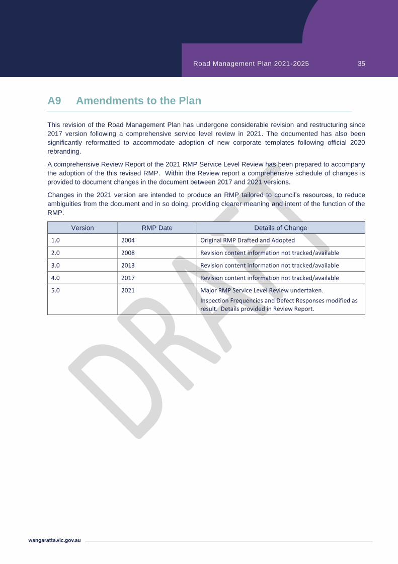
A9 Amendments to the Plan
This revision of the Road Management Plan has undergone considerable revision and restructuring since
2017 version following a comprehensive service level review in 2021. The documented has also been
significantly reformatted to accommodate adoption of new corporate templates following official 2020
rebranding.
A comprehensive Review Report of the 2021 RMP Service Level Review has been prepared to accompany
the adoption of the this revised RMP. Within the Review report a comprehensive schedule of changes is
provided to document changes in the document between 2017 and 2021 versions.
Changes in the 2021 version are intended to produce an RMP tailored to l’s es es, to reduce
ambiguities from the document and in so doing, providing clearer meaning and intent of the function of the
RMP.
Version RMP Date Details of Change
1.0 2004 Original RMP Drafted and Adopted
2.0 2008 Revision content information not tracked/available
3.0 2013 Revision content information not tracked/available
4.0 2017 Revision content information not tracked/available
5.0 2021 Major RMP Service Level Review undertaken.
Inspection Frequencies and Defect Responses modified as result. Details provided in Review Report.