Embed Size (px)
Citation preview
Roads, 2007: WEBS
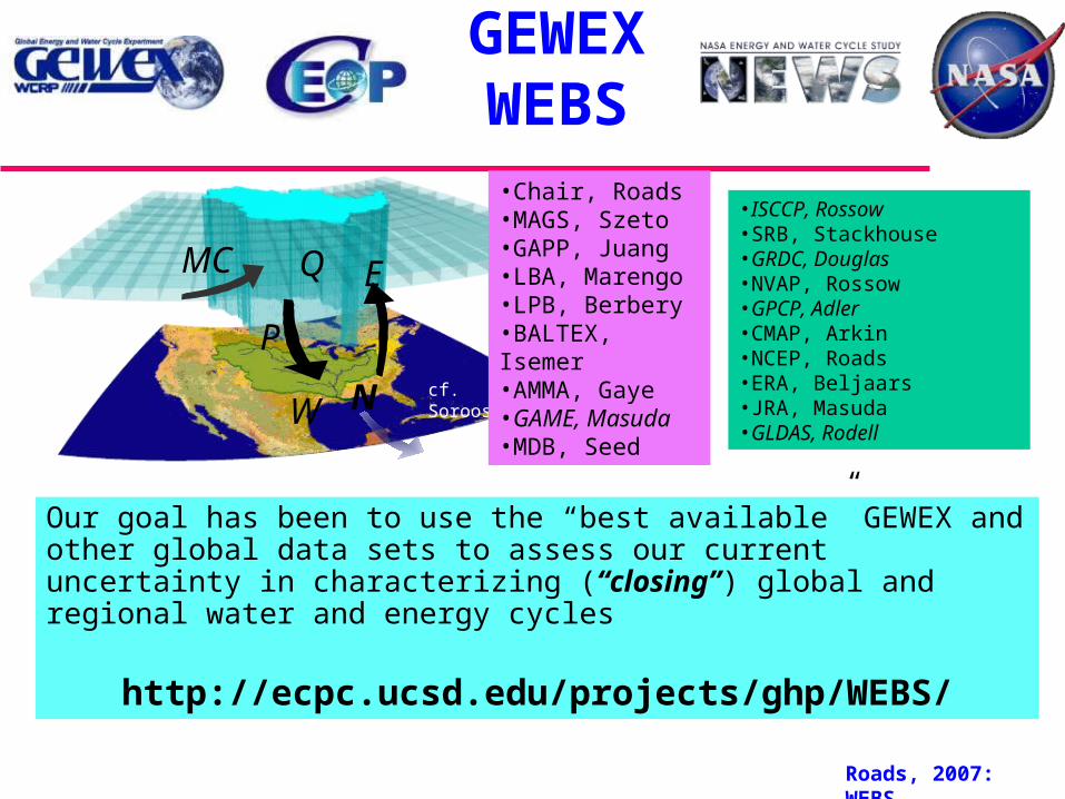
GEWEXWEBS
Our goal has been to use the “best available” GEWEX and other global data sets to assess our current uncertainty in characterizing (“closing”) global and regional water and energy cycles
http://ecpc.ucsd.edu/projects/ghp/WEBS/
E
W N
Q
P
MC
cf. Sorooshian
•ISCCP, Rossow•SRB, Stackhouse•GRDC, Douglas•NVAP, Rossow•GPCP, Adler•CMAP, Arkin•NCEP, Roads•ERA, Beljaars•JRA, Masuda•GLDAS, Rodell
•Chair, Roads•MAGS, Szeto•GAPP, Juang•LBA, Marengo•LPB, Berbery •BALTEX, Isemer•AMMA, Gaye•GAME, Masuda•MDB, Seed
Roads, 2007: WEBS
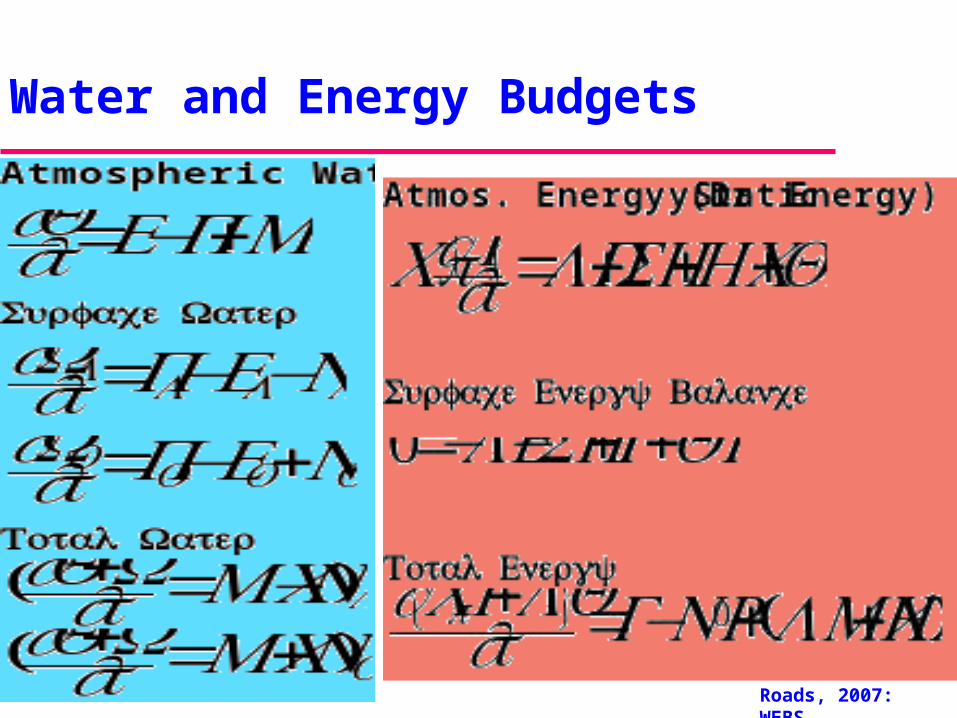
Water and Energy Budgets
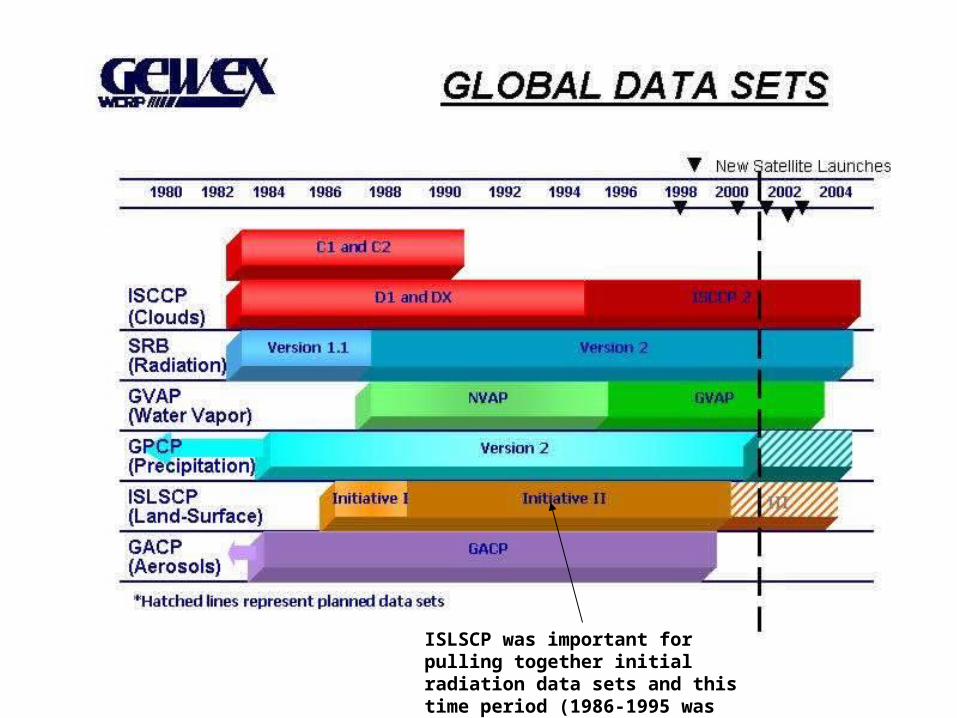
ISLSCP was important for pulling together initial radiation data sets and this time period (1986-1995 was chosen as the time period for this study.
Roads, 2007: WEBS
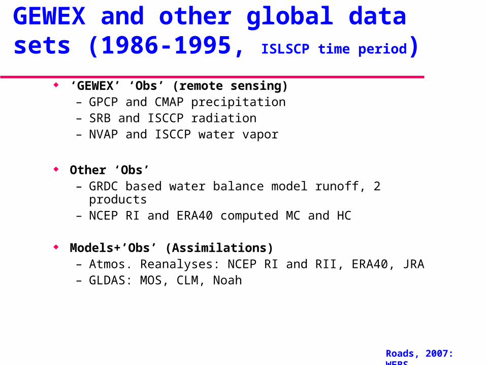
GEWEX and other global data sets (1986-1995, ISLSCP time period)
‘GEWEX’ ‘Obs’ (remote sensing)– GPCP and CMAP precipitation– SRB and ISCCP radiation– NVAP and ISCCP water vapor
Other ‘Obs’– GRDC based water balance model runoff, 2 products– NCEP RI and ERA40 computed MC and HC
Models+’Obs’ (Assimilations)– Atmos. Reanalyses: NCEP RI and RII, ERA40, JRA– GLDAS: MOS, CLM, Noah
Roads, 2007: WEBS
Many problematic and missing ‘obs’! Streamflow (runoff)
– Current global “observations” come from a combination of a tuned water balance model (P input) and GRDC archived streamflow observations.
• However, must be better than reanalyses or un-tuned LDAS runoff Atmospheric latent and sensible energy flux convergences (MC and HC)
– Atmospheric reanalysis products provide more global and regional detail and accuracy than previous radiosonde objective analyses, but
• Accumulated flux convergences are not standard reanalyses output and have previously been approximated from the 4xdaily output!
– These could be computed exactly (and have been!), afterwards, using analysis increments, but analysis increments are usually not freely available and were not available here!
Evaporation (and sensible heating)– Only atmospheric and land data assimilation systems currently have gridded values over land; – however there are now gridded remotely sensed based obs. over ocean (for a later time period
+1993?) Surface water (and tendencies, snowmelt, land skin temp.?)
– Only atmospheric and land data assimilation systems have gridded values readily available and even these are problematic
Roads, 2007: WEBS
How do we close water and energy budgets?
Compare available observation based and model based products with each other to assess potential uncertainty – Uncertainty in each of the relevant components tells us how well we can
“close” water and energy budgets. • For example, models, by construct, close water and energy budgets,
but they do this by having compensating errors (difference from nature) in each of the individual processes
– Differences between observation sets are, almost always, smaller than the differences between atmos. Reanalyses, and land data assimilation systems (LDAS)
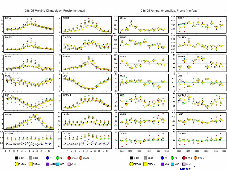
– We are therefore comparing annual to monthly means of:• Obs (2)• atmos. Reanalyses (4)• land data assimilation (3) • (And eventually ocean data assimilation?)
Roads, 2007: WEBS
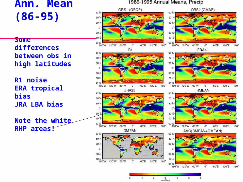
Precip.Ann. Mean (86-95)
Some differences between obs in high latitudes
R1 noiseERA tropical biasJRA LBA bias
Note the white RHP areas!
Roads, 2007: WEBS
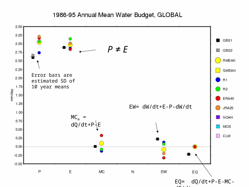
MCm = dQ/dt+P-E
EW= dW/dt+E-P-dW/dt
EQ= dQ/dt+P-E-MC-dQ/dt
€
P ≠ E
Error bars are estimated SD of 10 year means
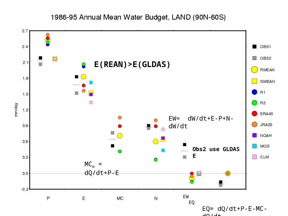
Obs2 use GLDAS E
EW= dW/dt+E-P+N-dW/dt
EQ= dQ/dt+P-E-MC-dQ/dt
EW EQ
E(REAN)>E(GLDAS)
MCm = dQ/dt+P-E
Roads, 2007: WEBS
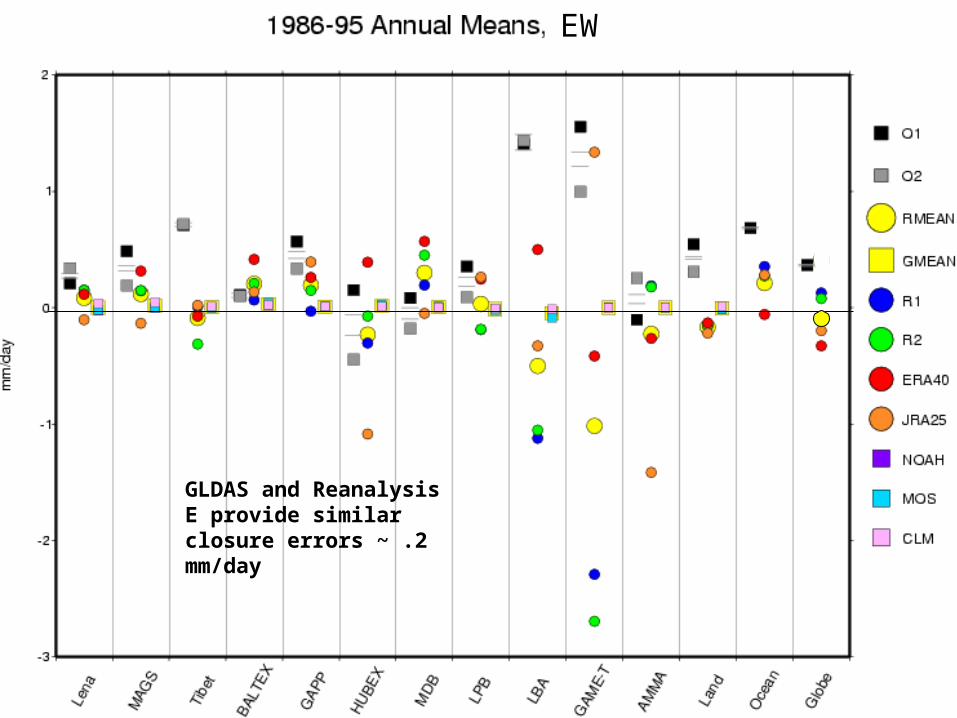
GLDAS evap results in closure errors ~ .3 mm/day; Reanalyses evap results in closure errors ~ .5 mm/day
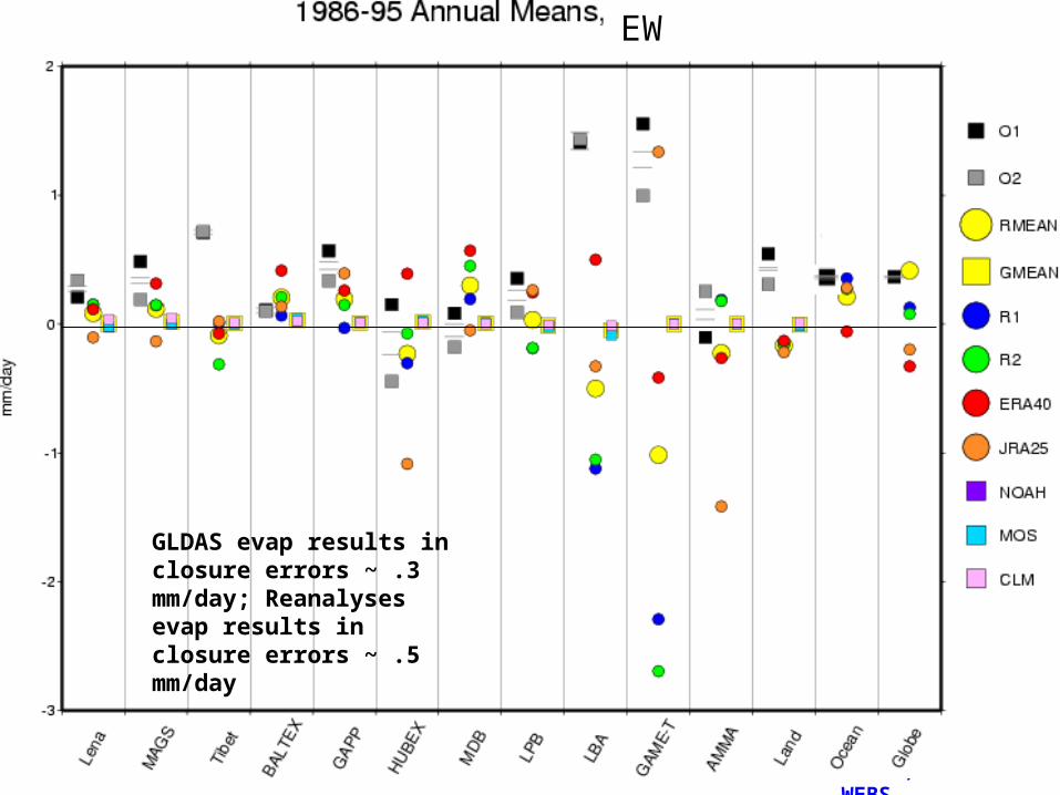
EW
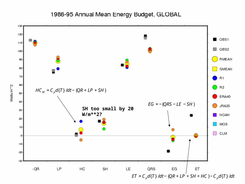
SH too small by 20 W/m**2?€
HCM =Cpd{T}/dt − (QR + LP + SH)
€
ET =Cpd{T}/dt − (QR + LP + SH + HC) −Cpd{T}/dt
€
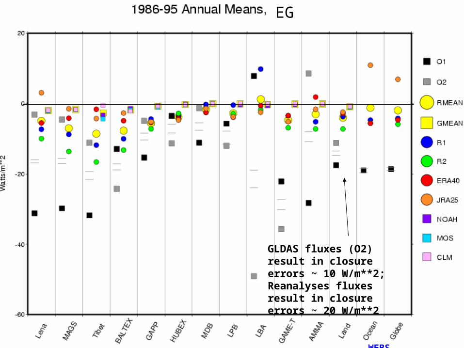
EG = −(QRS − LE − SH)
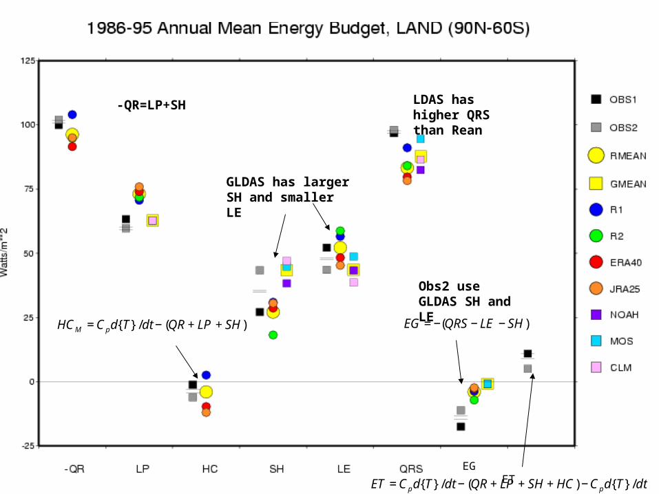
GLDAS has larger SH and smaller LE
LDAS has higher QRS than Rean
-QR=LP+SH
Obs2 use GLDAS SH and LE
EG ET
€
HCM =Cpd{T}/dt − (QR + LP + SH)
€
ET =Cpd{T}/dt − (QR + LP + SH + HC) −Cpd{T}/dt
€
EG = −(QRS − LE − SH)
Roads, 2007: WEBS
GLDAS fluxes (O2) result in closure errors ~ 10 W/m**2; Reanalyses fluxes result in closure errors ~ 20 W/m**2
EG
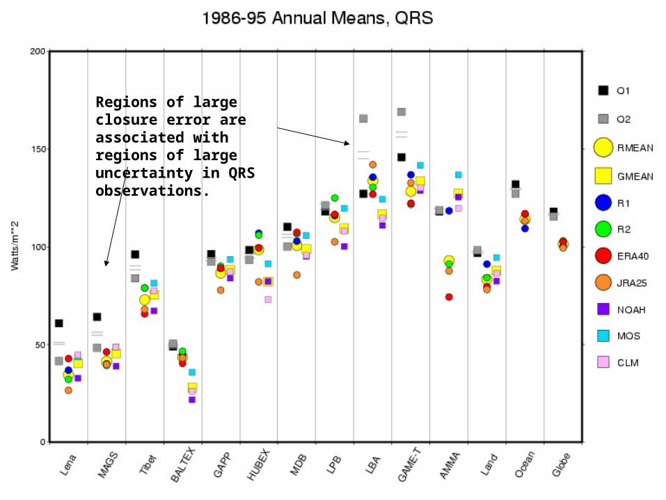
Regions of large closure error are associated with regions of large uncertainty in QRS observations.
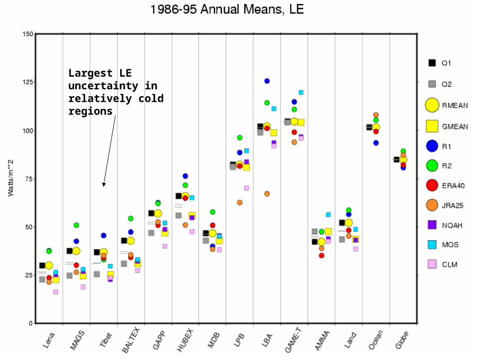
Largest LE uncertainty in relatively cold regions
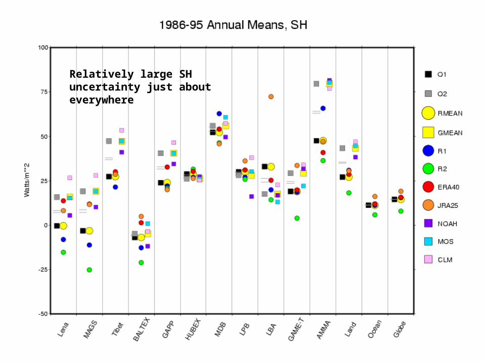
Relatively large SH uncertainty just about everywhere
€
SD = ( w(Obs−Obsc)∑ **2)**1/2
€
RMS = ( w(A −Obs)∑ ** 2)**1/2
€
SD = ( w(Obs−Obsc)∑ **2)**1/2
€
RMS = ( w(A −Obs)∑ ** 2)**1/2
€
SD = ( w(Obs−Obsc)∑ **2)**1/2
€
RMS = ( w(A −Obs)∑ ** 2)**1/2
Roads, 2007: WEBS
Summary Current uncertainty in global energy and water budgets over land is about 10-20%
(10-20 W/m**2 and .3-.5 mm/day [Bias and RMS])–Uncertainty probably mostly due to model derived latent and sensible heat fluxes, although observations (runoff, radiation) in some locations may also have relatively large errors. –GLDAS probably has slightly better estimates of surface fluxes than current coupled reanalyses because of greater obs. constraints• GLDAS SH ~ GLDAS LE whereas Rean LE 2x Rean SH • GLDAS SH about 2x Rean SH, GLDAS LE ~ .8 Rean LE
–GLDAS QRS RMS is larger than Rean QRS RMS in some locations?? We would like to eventually work on both ocean and land (i.e. true global) water and energy
budgets, but to do this we will need better combined ocean and land data sets–This will probably need to be for a different time period since many satellite ocean flux data sets begin in the early 90’s instead of the ISLSCP time period
–We would also like to eventually include MERRA* and other NEWS** datasets to compare with these WEBS datasets
Coupled and better constrained reanalysis a future possibility?
Roads, 2007: WEBS
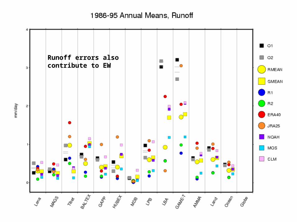
Runoff errors also contribute to EW
EW= dW/dt+E-P+N- dW/dt
EQ= dQ/dt+P-E-MC-dQ/dt
EW EQ
Roads, 2007: WEBS
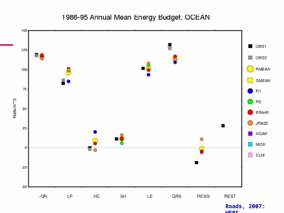
Reanalyses too wet?
LDAS has low QRS and low LE
-QR=LP+SH
Are RESG and REST measures of closure?
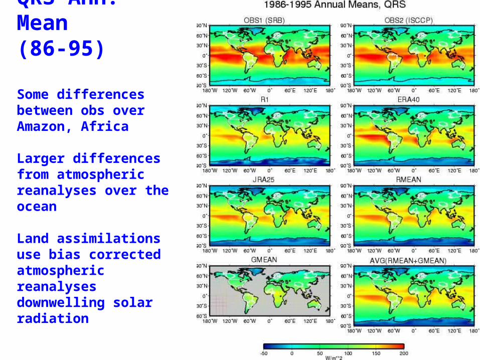
QRS Ann. Mean (86-95)
Some differences between obs over Amazon, Africa
Larger differences from atmospheric reanalyses over the ocean
Land assimilations use bias corrected atmospheric reanalyses downwelling solar radiation
Roads, 2007: WEBS
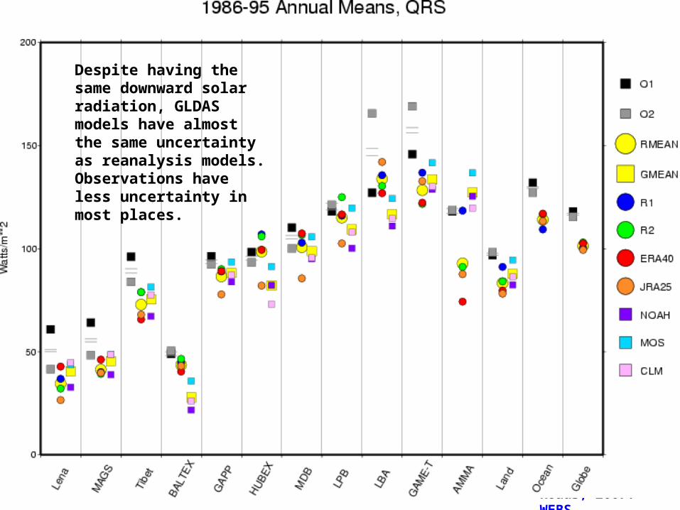
Despite having the same downward solar radiation, GLDAS models have almost the same uncertainty as reanalysis models. Observations have less uncertainty in most places.
Roads, 2007: WEBS
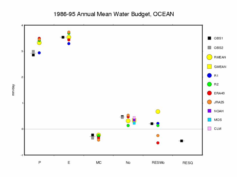
GLDAS and Reanalysis E provide similar closure errors ~ .2 mm/day
EW