Embed Size (px)
Citation preview

Roads, Rails, and Trails: Transportation-Related Archaeology in
Massachusetts
Eric S. Johnson
Massachusetts Historical Commission Boston, Massachusetts
© 2012

CONTENTS Transportation and Archaeology……………………. 1 The Route 495 Project Sites, Mansfield, Norton, Taunton, Raynham, and Bridgewater……………..…4 The Annasnappet Pond Sites, Carver.…..………....…8 The Oak Knoll Site, Lincoln……….…………………10 The Hartford Avenue Rockshelter, Uxbridge…….…14 The Foundry Pond Site, Hingham ……………….......18 The Franklin County Bikeway Site, Deerfield …........23 The Polpis Road Bicycle Path Sites, Nantucket……...27 The Metropolitan Railroad Site, Roxbury……...……34 The Highland Foundry Site, Roxbury ………….........38 The Sampson's Tavern Site, Lakeville………………..43 The Kingsley Tavern Site, Royalston………………....48 The Big Dig Sites, Boston…… ……………………......51 New Roads, Old Sites, New Stories ……..…...….........55
1
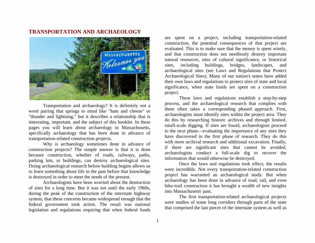
TRANSPORTATION AND ARCHAEOLOGY
Transportation and archaeology? It is definitely not a word pairing that springs to mind like "ham and cheese" or "thunder and lightning," but it describes a relationship that is interesting, important, and the subject of this booklet. In these pages you will learn about archaeology in Massachusetts, specifically archaeology that has been done in advance of transportation-related construction projects. Why is archaeology sometimes done in advance of construction projects? The simple answer is that it is done because construction, whether of roads, railways, paths, parking lots, or buildings, can destroy archaeological sites. Doing archaeological research before building begins allows us to learn something about life in the past before that knowledge is destroyed in order to meet the needs of the present.
Archaeologists have been worried about the destruction of sites for a long time. But it was not until the early 1960s, during the peak of the construction of the interstate highway system, that these concerns became widespread enough that the federal government took action. The result was national legislation and regulations requiring that when federal funds
are spent on a project, including transportation-related construction, the potential consequences of that project are evaluated. This is to make sure that the money is spent wisely, and that construction does not needlessly destroy important natural resources, sites of cultural significance, or historical sites, including buildings, bridges, landscapes, and archaeological sites (see Laws and Regulations that Protect Archaeological Sites). Many of our nation's states have added their own laws and regulations to protect sites of state and local significance, when state funds are spent on a construction project. These laws and regulations establish a step-by-step process, and the archaeological research that complies with them often takes a corresponding phased approach. First, archaeologists must identify sites within the project area. They do this by researching historic archives and through limited, small-scale digging. If sites are found, archaeologists proceed to the next phase—evaluating the importance of any sites they have discovered in the first phase of research. They do this with more archival research and additional excavation. Finally, if there are significant sites that cannot be avoided, archaeologists conduct a full-scale dig to recover the information that would otherwise be destroyed. Once the laws and regulations took effect, the results were incredible. Not every transportation-related construction project has warranted an archaeological study. But when archaeology has been done in advance of road, rail, and even bike-trail construction it has brought a wealth of new insights into Massachusetts' past. The first transportation-related archaeological projects were studies of some long corridors through parts of the state that comprised the last pieces of the interstate system as well as
2
important state highways. These gave archaeologists an unprecedented opportunity to test big slices of the landscape and to compare the deep histories of people's use of different environments. Gradually, the focus of transportation construction shifted to maintenance, repair, and redesign of problem traffic areas. Archaeologists focused on these smaller study areas, in which they occasionally found truly outstanding resources. In the Boston area, transportation construction was diverse, including commuter rail and, of course, the Big Dig. Archaeological projects associated with these developments unearthed exciting new information about homes, businesses, and industries in our state's capital city. In suburban and rural parts of the state, bike paths were created, and some amazing new archaeological sites were discovered in the process. If you were to ask people "What is archaeology?" many might answer that it is digging up ancient artifacts—objects made or modified by people—but that is really only a small part of archaeology. Archaeologists dig, find, and study artifacts in order to learn about human behavior. People are unique in the way we make and modify materials for all sorts of purposes, from finding and preparing food, to clothing and housing ourselves, to communicating ideas. Archaeologists call all these made and modified things "material culture." Most people call it "stuff." In addition to artifacts, archaeologists also distinguish "features" as an important category of material culture. Features are basically complex artifacts or arrangements of artifacts that can't be picked up in one piece. Features include things like ancient firepits where food was cooked, house floors, privies (pits dug beneath outhouses), and ditches. Archaeologists find most of this material culture concentrated in places where people have lived and worked; they call these concentrations "sites." Much archaeological
research is focused on sites and what the artifacts and features they contain can tell us about the past.
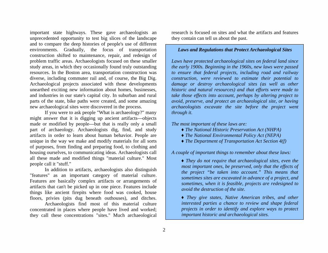
Laws and Regulations that Protect Archaeological Sites
Laws have protected archaeological sites on federal land since the early 1900s. Beginning in the 1960s, new laws were passed to ensure that federal projects, including road and railway construction, were reviewed to estimate their potential to damage or destroy archaeological sites (as well as other historic and natural resources) and that efforts were made to take those effects into account, perhaps by altering project to avoid, preserve, and protect an archaeological site, or having archaeologists excavate the site before the project went through it. The most important of these laws are:
♦ The National Historic Preservation Act (NHPA) ♦ The National Environmental Policy Act (NEPA) ♦ The Department of Transportation Act Section 4(f)
A couple of important things to remember about these laws:
♦ They do not require that archaeological sites, even the most important ones, be preserved, only that the effects of the project “be taken into account.” This means that sometimes sites are excavated in advance of a project, and sometimes, when it is feasible, projects are redesigned to avoid the destruction of the site.
♦ They give states, Native American tribes, and other interested parties a chance to review and shape federal projects in order to identify and explore ways to protect important historic and archaeological sites.
3
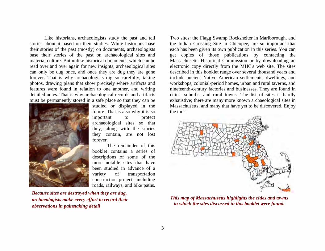
Because sites are destroyed when they are dug, archaeologists make every effort to record their observations in painstaking detail
Like historians, archaeologists study the past and tell stories about it based on their studies. While historians base their stories of the past (mostly) on documents, archaeologists base their stories of the past on archaeological sites and material culture. But unlike historical documents, which can be read over and over again for new insights, archaeological sites can only be dug once, and once they are dug they are gone forever. That is why archaeologists dig so carefully, taking photos, drawing plans that show precisely where artifacts and features were found in relation to one another, and writing detailed notes. That is why archaeological records and artifacts must be permanently stored in a safe place so that they can be
studied or displayed in the future. That is also why it is so important to protect archaeological sites so that they, along with the stories they contain, are not lost forever. The remainder of this booklet contains a series of descriptions of some of the more notable sites that have been studied in advance of a variety of transportation construction projects including roads, railways, and bike paths.
Two sites: the Flagg Swamp Rockshelter in Marlborough, and the Indian Crossing Site in Chicopee, are so important that each has been given its own publication in this series. You can get copies of those publications by contacting the Massachusetts Historical Commission or by downloading an electronic copy directly from the MHC's web site. The sites described in this booklet range over several thousand years and include ancient Native American settlements, dwellings, and workshops, colonial-period homes, urban and rural taverns, and nineteenth-century factories and businesses. They are found in cities, suburbs, and rural towns. The list of sites is hardly exhaustive; there are many more known archaeological sites in Massachusetts, and many that have yet to be discovered. Enjoy the tour!
This map of Massachusetts highlights the cities and towns in which the sites discussed in this booklet were found.
4
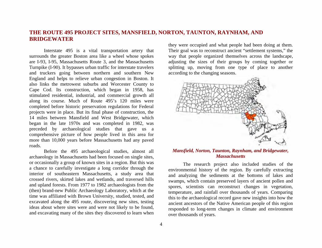
THE ROUTE 495 PROJECT SITES, MANSFIELD, NORTON, TAUNTON, RAYNHAM, AND BRIDGEWATER Interstate 495 is a vital transportation artery that surrounds the greater Boston area like a wheel whose spokes are I-93, I-95, Massachusetts Route 3, and the Massachusetts Turnpike (I-90). It bypasses urban traffic for interstate travelers and truckers going between northern and southern New England and helps to relieve urban congestion in Boston. It also links the metrowest suburbs and Worcester County to Cape Cod. Its construction, which began in 1958, has stimulated residential, industrial, and commercial growth all along its course. Much of Route 495’s 120 miles were completed before historic preservation regulations for Federal projects were in place. But its final phase of construction, the 14 miles between Mansfield and West Bridgewater, which began in the late 1970s and was completed in 1982, was preceded by archaeological studies that gave us a comprehensive picture of how people lived in this area for more than 10,000 years before Massachusetts had any paved roads. Before the 495 archaeological studies, almost all archaeology in Massachusetts had been focused on single sites, or occasionally a group of known sites in a region. But this was a chance to carefully investigate a long corridor through the interior of southeastern Massachusetts, a study area that crossed rivers, skirted lakes and wetlands, and traversed hills and upland forests. From 1977 to 1982 archaeologists from the (then) brand-new Public Archaeology Laboratory, which at the time was affiliated with Brown University, studied, tested, and excavated along the 495 route, discovering new sites, testing ideas about where sites were and were not likely to be found, and excavating many of the sites they discovered to learn when
they were occupied and what people had been doing at them. Their goal was to reconstruct ancient “settlement systems,” the way that people organized themselves across the landscape, adjusting the sizes of their groups by coming together or splitting up, moving from one type of place to another according to the changing seasons.
Mansfield, Norton, Taunton, Raynham, and Bridgewater,
Massachusetts The research project also included studies of the environmental history of the region. By carefully extracting and analyzing the sediments at the bottoms of lakes and swamps, which contain preserved layers of ancient pollen and spores, scientists can reconstruct changes in vegetation, temperature, and rainfall over thousands of years. Comparing this to the archaeological record gave new insights into how the ancient ancestors of the Native American people of this region responded to long-term changes in climate and environment over thousands of years.
5
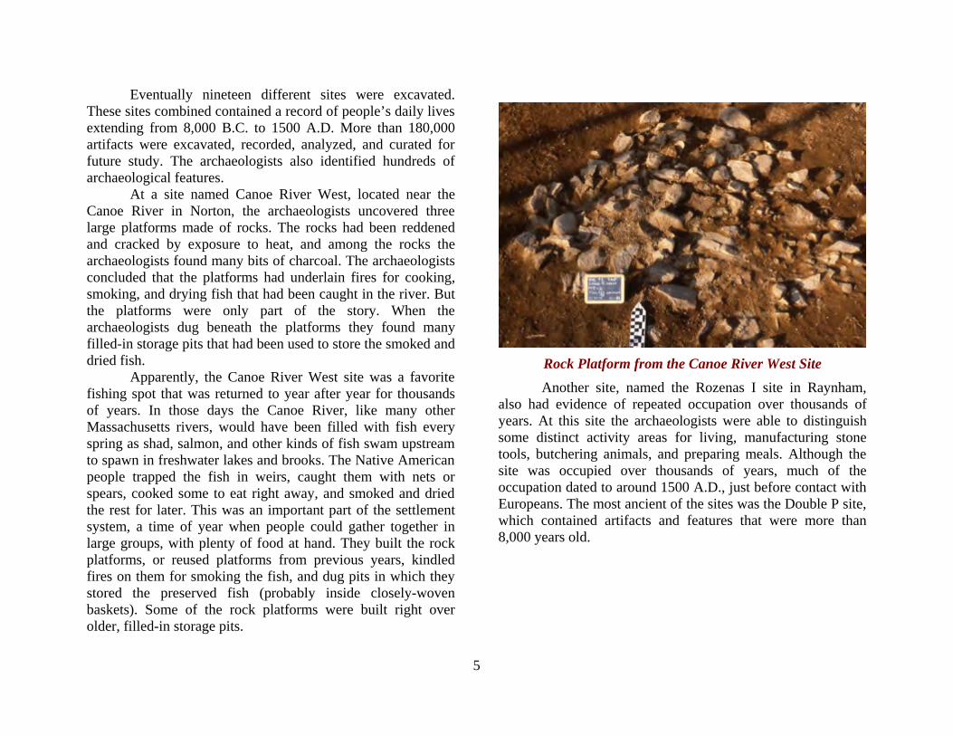
Eventually nineteen different sites were excavated. These sites combined contained a record of people’s daily lives extending from 8,000 B.C. to 1500 A.D. More than 180,000 artifacts were excavated, recorded, analyzed, and curated for future study. The archaeologists also identified hundreds of archaeological features. At a site named Canoe River West, located near the Canoe River in Norton, the archaeologists uncovered three large platforms made of rocks. The rocks had been reddened and cracked by exposure to heat, and among the rocks the archaeologists found many bits of charcoal. The archaeologists concluded that the platforms had underlain fires for cooking, smoking, and drying fish that had been caught in the river. But the platforms were only part of the story. When the archaeologists dug beneath the platforms they found many filled-in storage pits that had been used to store the smoked and dried fish. Apparently, the Canoe River West site was a favorite fishing spot that was returned to year after year for thousands of years. In those days the Canoe River, like many other Massachusetts rivers, would have been filled with fish every spring as shad, salmon, and other kinds of fish swam upstream to spawn in freshwater lakes and brooks. The Native American people trapped the fish in weirs, caught them with nets or spears, cooked some to eat right away, and smoked and dried the rest for later. This was an important part of the settlement system, a time of year when people could gather together in large groups, with plenty of food at hand. They built the rock platforms, or reused platforms from previous years, kindled fires on them for smoking the fish, and dug pits in which they stored the preserved fish (probably inside closely-woven baskets). Some of the rock platforms were built right over older, filled-in storage pits.
Rock Platform from the Canoe River West Site
Another site, named the Rozenas I site in Raynham, also had evidence of repeated occupation over thousands of years. At this site the archaeologists were able to distinguish some distinct activity areas for living, manufacturing stone tools, butchering animals, and preparing meals. Although the site was occupied over thousands of years, much of the occupation dated to around 1500 A.D., just before contact with Europeans. The most ancient of the sites was the Double P site, which contained artifacts and features that were more than 8,000 years old.

6
A Sample of Artifacts from the 495 Project Sites Top (left-right) Bifurcate Base (spear) point from the Double
P Site; Neville point from the Bay Street I Site; Brewerton Eared Triangle point from the Snake River West Site;
Squibnocket Triangle from the Canoe River West Site; Small Stemmed point from the Bay Street I Site. Bottom (left-right)
Levanna Triangle point from the Rozenas I Site; awl or piercing tool from the Rozenas II Site; grooved stone
netsinker from the Treatment Plant Site; ground stone adze from the Bay Street I Site
The information on ancient environments that was collected as part of the 495 project provided explanations for some of the patterns that emerged from the archaeological studies. For example, the environmental studies showed that between about 4,000 and 3,000 years ago, there was a period when the climate became much drier. People responded to this environmental challenge by adjusting their settlement systems. Settlements around the largest and deepest lakes and wetlands (those least affected by the drought), were lived in by more people at once and for longer periods of time. The sites grew large and contained a greater variety of tools and features, including food-storage features. Storing of food, as in the storage pits found at the Canoe River West site, is a sensible solution to the problem of changing environment. Away from the large settlements were smaller special-purpose sites, where people lived for short periods and focused on just a few tasks. These sites are small and contain a limited variety of tools. During this time, people were settling in one place in a large group for a long period of time and sending out smaller, special-purpose expeditions from the base settlement, rather than living in smaller groups and moving more frequently from place to place as they had done before. The Route 495 project was a landmark in Massachusetts archaeology in many ways. It was the first large-scale transportation-related archaeological study in the Commonwealth. It was the first modern archaeological study of a big slice of the Massachusetts landscape. It was a multidisciplinary research project, combining archaeology and environmental studies. It was a training ground for a generation of archaeologists, many of whom still contribute to New England archaeology. In the end, it added greatly to our knowledge of the ancient history of the land and the Native people of Massachusetts.
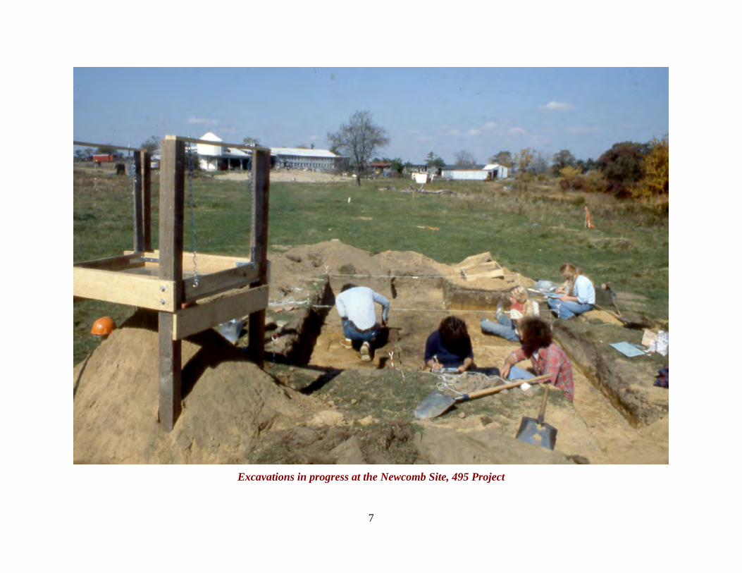
7
Excavations in progress at the Newcomb Site, 495 Project
8
The Annasnappet Pond Sites, Carver In the late 1970s, The Massachusetts Department of Transportation (then known as the Massachusetts Department of Public Works) began planning improvements to Route 44. This road is a major east-west transportation route, running from Plymouth through Taunton and ultimately to Providence, Rhode Island. The route was narrow and meandering in places, and the planned alterations were designed to cut travel time and improve safety. Archaeological testing began with a group from Harvard University’s Institute for Conservation Archaeology (ICA), who began testing several alternative routes in the fall and early winter of 1978. The ICA archaeologists found several ancient sites around Annasnappet Pond, a large complex of cranberry bogs surrounded by sandy knolls in a rural part of the town of Carver.
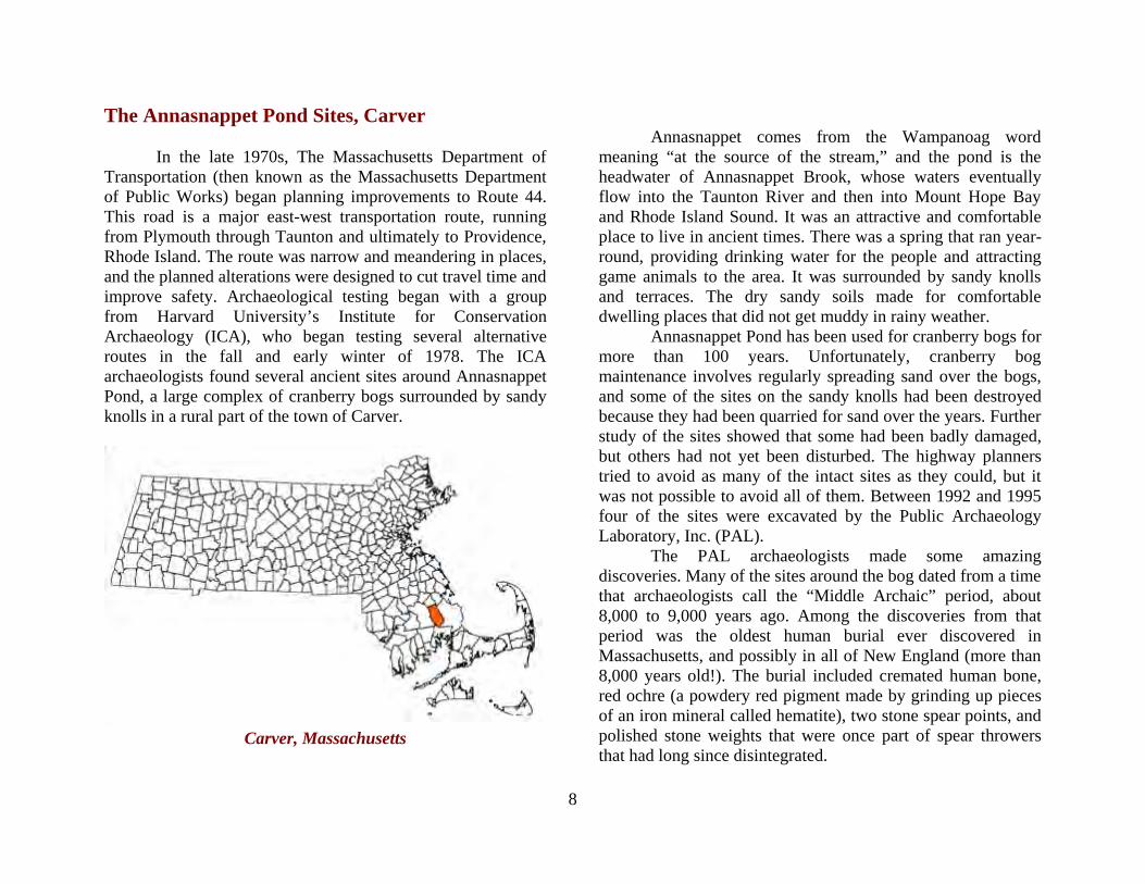
Carver, Massachusetts
Annasnappet comes from the Wampanoag word meaning “at the source of the stream,” and the pond is the headwater of Annasnappet Brook, whose waters eventually flow into the Taunton River and then into Mount Hope Bay and Rhode Island Sound. It was an attractive and comfortable place to live in ancient times. There was a spring that ran year-round, providing drinking water for the people and attracting game animals to the area. It was surrounded by sandy knolls and terraces. The dry sandy soils made for comfortable dwelling places that did not get muddy in rainy weather. Annasnappet Pond has been used for cranberry bogs for more than 100 years. Unfortunately, cranberry bog maintenance involves regularly spreading sand over the bogs, and some of the sites on the sandy knolls had been destroyed because they had been quarried for sand over the years. Further study of the sites showed that some had been badly damaged, but others had not yet been disturbed. The highway planners tried to avoid as many of the intact sites as they could, but it was not possible to avoid all of them. Between 1992 and 1995 four of the sites were excavated by the Public Archaeology Laboratory, Inc. (PAL). The PAL archaeologists made some amazing discoveries. Many of the sites around the bog dated from a time that archaeologists call the “Middle Archaic” period, about 8,000 to 9,000 years ago. Among the discoveries from that period was the oldest human burial ever discovered in Massachusetts, and possibly in all of New England (more than 8,000 years old!). The burial included cremated human bone, red ochre (a powdery red pigment made by grinding up pieces of an iron mineral called hematite), two stone spear points, and polished stone weights that were once part of spear throwers that had long since disintegrated.
9
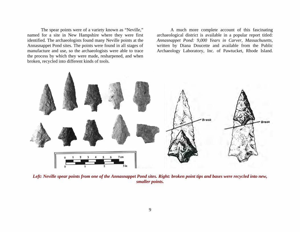
The spear points were of a variety known as “Neville,” named for a site in New Hampshire where they were first identified. The archaeologists found many Neville points at the Annasnappet Pond sites. The points were found in all stages of manufacture and use, so the archaeologists were able to trace the process by which they were made, resharpened, and when broken, recycled into different kinds of tools.
A much more complete account of this fascinating archaeological district is available in a popular report titled: Annasnappet Pond: 9,000 Years in Carver, Massachusetts, written by Diana Doucette and available from the Public Archaeology Laboratory, Inc. of Pawtucket, Rhode Island.
Left: Neville spear points from one of the Annasnappet Pond sites. Right: broken point tips and bases were recycled into new, smaller points.

10
THE OAK KNOLL SITE, LINCOLN Ancient Native American sites in Massachusetts present many challenges to the archaeologists who excavate and interpret them. One challenge is that most of the sites were visited again and again for thousands of years (not surprising since they were good places to stay). But it can be difficult to separate the artifacts and features left behind by one group of occupants from those left by the next and the next. In some parts of the world, floods or volcanoes deposit layers of sediment on sites that help to separate at least some of the episodes of human occupation. We don’t have volcanoes in Massachusetts (knock wood) and there are very few places where floods regularly deposit layers of silt. So at most sites all the artifacts from thousands of years of history are contained in a fairly thin layer of soil, where they are moved up and down by burrowing animals, frost action, and tree roots. On top of that, most of the state has been plowed or harrowed at one time or another, and this mixes everything up even more. So a site that contains the material from a single episode of occupation (archaeologists call this a “single-component site”) is a rare find indeed. One such site was the Oak Knoll site in the town of Lincoln. The intersection of Massachusetts Routes 2 and 2A in Lincoln—known as Crosby Corner—had long been a problem traffic area. In the late 1990s Mass Highway planned a road realignment and reconstruction to make driving through Crosby Corner safer and more convenient. In 1998, archaeologists from University of Massachusetts Archaeological Services began a study to identify any archaeological sites that might be affected by the proposed realignment. The study was completed with the excavation of the Oak Knoll site in 2000.
Lincoln, Massachusetts
The archaeologists excavated twenty-five square meters of the site. All the excavation squares were in a single group, giving the archaeologists a wide view of the site. The plan of the Oak Knoll site on the next page shows the squares and trenches the archaeologists excavated. Each is labeled “EU” (for excavation unit) followed by a number or “STP” for shovel test pit. The shovel test pits were used to discover the site; the excavation units to expose the site area for mapping and detailed study. As they excavated, the archaeologists carefully noted the colors and textures of the soils they were digging through, as well as the artifacts they found. From the ground surface down about four to six inches was a brown soil called a plowzone. This soil is created by plowing, and is a sort of “default” upper soil layer in most of Massachusetts. Below this was yellowish-brown subsoil, which got gradually lighter with
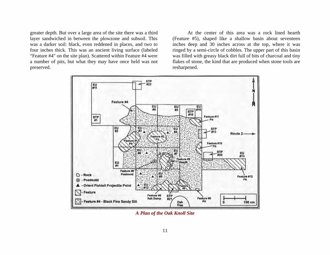
11
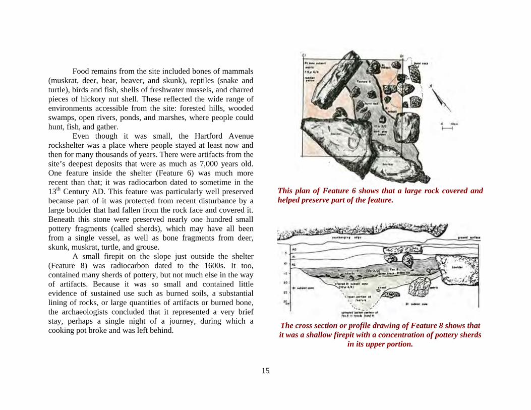
greater depth. But over a large area of the site there was a third layer sandwiched in between the plowzone and subsoil. This was a darker soil: black, even reddened in places, and two to four inches thick. This was an ancient living surface (labeled “Feature #4" on the site plan). Scattered within Feature #4 were a number of pits, but what they may have once held was not preserved.
At the center of this area was a rock lined hearth (Feature #5), shaped like a shallow basin about seventeen inches deep and 30 inches across at the top, where it was ringed by a semi-circle of cobbles. The upper part of this basin was filled with greasy black dirt full of bits of charcoal and tiny flakes of stone, the kind that are produced when stone tools are resharpened.
A Plan of the Oak Knoll Site
12
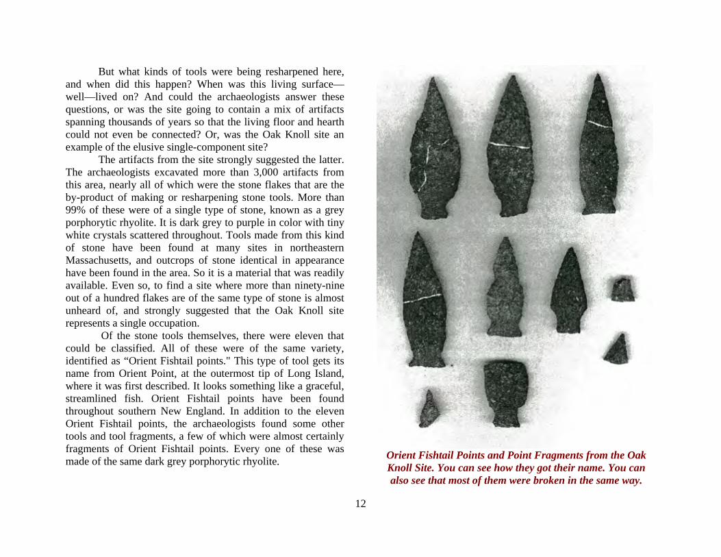
But what kinds of tools were being resharpened here, and when did this happen? When was this living surface—well—lived on? And could the archaeologists answer these questions, or was the site going to contain a mix of artifacts spanning thousands of years so that the living floor and hearth could not even be connected? Or, was the Oak Knoll site an example of the elusive single-component site? The artifacts from the site strongly suggested the latter. The archaeologists excavated more than 3,000 artifacts from this area, nearly all of which were the stone flakes that are the by-product of making or resharpening stone tools. More than 99% of these were of a single type of stone, known as a grey porphorytic rhyolite. It is dark grey to purple in color with tiny white crystals scattered throughout. Tools made from this kind of stone have been found at many sites in northeastern Massachusetts, and outcrops of stone identical in appearance have been found in the area. So it is a material that was readily available. Even so, to find a site where more than ninety-nine out of a hundred flakes are of the same type of stone is almost unheard of, and strongly suggested that the Oak Knoll site represents a single occupation. .Of the stone tools themselves, there were eleven that could be classified. All of these were of the same variety, identified as “Orient Fishtail points." This type of tool gets its name from Orient Point, at the outermost tip of Long Island, where it was first described. It looks something like a graceful, streamlined fish. Orient Fishtail points have been found throughout southern New England. In addition to the eleven Orient Fishtail points, the archaeologists found some other tools and tool fragments, a few of which were almost certainly fragments of Orient Fishtail points. Every one of these was made of the same dark grey porphorytic rhyolite
Orient Fishtail Points and Point Fragments from the Oak Knoll Site. You can see how they got their name. You can also see that most of them were broken in the same way.
.

13
When they can be reliably associated with a radiocarbon date, Orient Fishtail points date to approximately 3,000 years ago, give or take a few hundred years. A piece of charcoal from the central hearth feature was radiocarbon dated to between 3155 and 2795 BP (Before Present). So now the archaeologists had two pieces of evidence (that agreed with each other!) for the age of the site. The archaeologists noticed that almost all of the Orient Fishtail points were broken in the same way: across the middle portion of the blade. The one exception (on the upper left of the photo) has a break that runs part way across the blade, then hits a grain or flaw in the rock and follows that down toward the base. Experiments with stone tools show that this kind of break is caused by cutting or sawing with the side of the blade. Close examination of the complete points showed that most had some crushing or grinding around the notches above the base: evidence that they had been hafted, or attached to a handle. The edges of the points were also examined for evidence of wear from use. There was some polish along the edges, but no scratches or striations. This is the kind of wear that experiments show was caused by cutting semi-hard material like leather. In summary, the result of the analysis was that the “points” were actually used as knives! So what story does this single component Orient site tell? The site was occupied only once, for a fairly short period of time. Around 3,000 years ago, a group of people arrived here, bringing with them several rhyolite knives with handles probably made of wood or bone, and perhaps some unfinished pieces of the same material for making more tools. They dug out a pit, lined it with rocks, and placed cobbles around part of it to create the equivalent of a stove. They used the stone tools as knives to cut something that, if any was left behind, did not preserve. They broke several tools in the process and, judging
by the density of the flakes, made some replacements. Perhaps they used the surrounding pits to store what they made with the knives or dispose of waste products. As for exactly what they were making, what they may have eaten, what clothing they might have worn, the type of dwelling they may have built—these remain as yet unknown. Further reading: A detailed report on the Oak Knoll Site written by Christopher L. Donta, the archaeologist who directed the excavation, was published in Volume 64, number 2 of the Bulletin of the Massachusetts Archaeological Society in Fall 2003.
Experimental Archaeology One of the ways archaeologists can learn more about the artifacts and features that they find is by making and using them. This can be as simple(?) as learning to flake stone, or weaving cloth on a replica of an ancient loom, or cutting wood with a stone axe, or as complicated as trying to build a pyramid in the Egyptian style. By attempting these things archaeologists gain an appreciation for the skills and knowledge of ancient peoples. Archaeologists can also learn more about the activities that went into producing the materials that they dig up and study. They also improve their ability to recognize different activities that are encoded in artifacts. These can be subtle, like the minute scratches and chips on the edge of a tool that come from cutting hard material, or the different ways that artifacts break when used for different tasks. Experimental archaeology has contributed greatly to archaeologists' understanding of the past. And it can be fun!

14
The Hartford Avenue Rockshelter, Uxbridge Route 146 was originally built in the 1940s as a link between Worcester, Massachusetts and Providence, Rhode Island, cities that have at various times been linked by rivers, footpaths, cart roads, canals, and railroads. When large segments of the road were upgraded in the 1980s, the roadwork was preceded by an archaeological study. Archaeologists from the Public Archaeology Laboratory, which was then affiliated with Brown University, began the research in the spring of 1978, well in advance of the scheduled construction. In the town of Uxbridge, they examined several likely looking rock faces and overhangs. Only one turned out to be an archaeological site, but what a site it was! It contained a dense deposit of well-preserved artifacts, features, and food remains.
Uxbridge, Massachusetts
The Hartford Avenue rockshelter was a very small site. The shelter’s rear wall was a vertical rock face more than sixteen feet high, with an overhang near the base. The rock was somewhat exposed to the northwest, but was well protected from winds from the north and northeast. The total living area was only about 86 square feet (8 square meters); a slope outside the living area that also contained some artifacts and features added an additional 129 square feet (12 square meters). It was a tight fit, and the rockshelter could not have held more than a small group—say, a single family—at one time.
Plan of the Hartford Avenue Rockshelter Showing Excavation Squares
15
Food remains from the site included bones of mammals (muskrat, deer, bear, beaver, and skunk), reptiles (snake and turtle), birds and fish, shells of freshwater mussels, and charred pieces of hickory nut shell. These reflected the wide range of environments accessible from the site: forested hills, wooded swamps, open rivers, ponds, and marshes, where people could hunt, fish, and gather. Even though it was small, the Hartford Avenue rockshelter was a place where people stayed at least now and then for many thousands of years. There were artifacts from the site’s deepest deposits that were as much as 7,000 years old. One feature inside the shelter (Feature 6) was much more recent than that; it was radiocarbon dated to sometime in the 13th Century AD. This feature was particularly well preserved because part of it was protected from recent disturbance by a large boulder that had fallen from the rock face and covered it. Beneath this stone were preserved nearly one hundred small pottery fragments (called sherds), which may have all been from a single vessel, as well as bone fragments from deer, skunk, muskrat, turtle, and grouse. A small firepit on the slope just outside the shelter (Feature 8) was radiocarbon dated to the 1600s. It too, contained many sherds of pottery, but not much else in the way of artifacts. Because it was so small and contained little evidence of sustained use such as burned soils, a substantial lining of rocks, or large quantities of artifacts or burned bone, the archaeologists concluded that it represented a very brief stay, perhaps a single night of a journey, during which a cooking pot broke and was left behind.
This plan of Feature 6 shows that a large rock covered and helped preserve part of the feature.
The cross section or profile drawing of Feature 8 shows that it was a shallow firepit with a concentration of pottery sherds
in its upper portion.
16
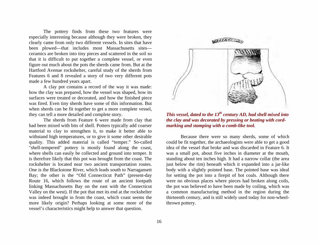
The pottery finds from these two features were especially interesting because although they were broken, they clearly came from only two different vessels. In sites that have been plowed—that includes most Massachusetts sites—ceramics are broken into tiny pieces and scattered in the soil so that it is difficult to put together a complete vessel, or even figure out much about the pots the sherds came from. But at the Hartford Avenue rockshelter, careful study of the sherds from Features 6 and 8 revealed a story of two very different pots made a few hundred years apart. A clay pot contains a record of the way it was made: how the clay was prepared, how the vessel was shaped, how its surfaces were treated or decorated, and how the finished piece was fired. Even tiny sherds have some of this information. But when sherds can be fit together to get a more complete vessel, they can tell a more detailed and complete story. The sherds from Feature 6 were made from clay that had been mixed with bits of shell. Potters typically add coarser material to clay to strengthen it, to make it better able to withstand high temperatures, or to give it some other desirable quality. This added material is called “temper.” So-called "shell-tempered" pottery is mostly found along the coast, where shells can easily be collected and ground into temper. It is therefore likely that this pot was brought from the coast. The rockshelter is located near two ancient transportation routes. One is the Blackstone River, which leads south to Narragansett Bay; the other is the “Old Connecticut Path” (present-day Route 16, which follows the route of an ancient footpath linking Massachusetts Bay on the east with the Connecticut Valley on the west). If the pot that met its end at the rockshelter was indeed brought in from the coast, which coast seems the more likely origin? Perhaps looking at some more of the vessel’s characteristics might help to answer that question.
This vessel, dated to the 13th century AD, had shell mixed into the clay and was decorated by pressing or beating with cord-marking and stamping with a comb-like tool. Because there were so many sherds, some of which could be fit together, the archaeologists were able to get a good idea of the vessel that broke and was discarded in Feature 6. It was a small pot, about five inches in diameter at the mouth, standing about ten inches high. It had a narrow collar (the area just below the rim) beneath which it expanded into a jar-like body with a slightly pointed base. The pointed base was ideal for setting the pot into a firepit of hot coals. Although there were no obvious places where pieces had broken along coils, the pot was believed to have been made by coiling, which was a common manufacturing method in the region during the thirteenth century, and is still widely used today for non-wheel-thrown pottery.
17
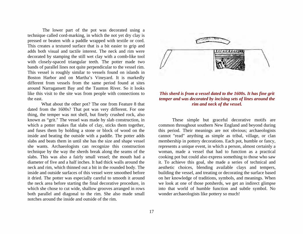
The lower part of the pot was decorated using a technique called cord-marking, in which the not yet dry clay is pressed or beaten with a paddle wrapped with textile or cord. This creates a textured surface that is a bit easier to grip and adds both visual and tactile interest. The neck and rim were decorated by stamping the still wet clay with a comb-like tool with closely-spaced triangular teeth. The potter made two bands of parallel lines not quite perpendicular to the vessel rim. This vessel is roughly similar to vessels found on islands in Boston Harbor and on Martha’s Vineyard. It is markedly different from vessels from the same period found at sites around Narragansett Bay and the Taunton River. So it looks like this visit to the site was from people with connections to the east. What about the other pot? The one from Feature 8 that dated from the 1600s? That pot was very different. For one thing, the temper was not shell, but finely crushed rock, also known as “grit." The vessel was made by slab construction, in which a potter makes flat slabs of clay, sticks them together, and fuses them by holding a stone or block of wood on the inside and beating the outside with a paddle. The potter adds slabs and beats them in until she has the size and shape vessel she wants. Archaeologists can recognize this construction technique by the way the sherds break along the seams of the slabs. This was also a fairly small vessel; the mouth had a diameter of five and a half inches. It had thick walls around the neck and rim, which thinned out a bit in the rounded body. The inside and outside surfaces of this vessel were smoothed before it dried. The potter was especially careful to smooth it around the neck area before starting the final decorative procedure, in which she chose to cut wide, shallow grooves arranged in rows both parallel and diagonal to the rim. She also made small notches around the inside and outside of the rim.
This sherd is from a vessel dated to the 1600s. It has fine grit temper and was decorated by incising sets of lines around the
rim and neck of the vessel. These simple but graceful decorative motifs are common throughout southern New England and beyond during this period. Their meanings are not obvious; archaeologists cannot "read" anything as simple as tribal, village, or clan membership in pottery decorations. Each pot, humble or fancy, represents a unique event, in which a person, almost certainly a woman, made a vessel that had to function as a practical cooking pot but could also express something to those who saw it. To achieve this goal, she made a series of technical and aesthetic choices, blending available clays and tempers, building the vessel, and treating or decorating the surface based on her knowledge of traditions, symbols, and meanings. When we look at one of those potsherds, we get an indirect glimpse into that world of humble function and subtle symbol. No wonder archaeologists like pottery so much!
18
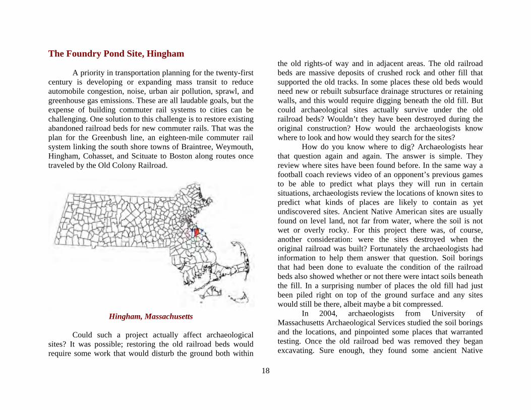
The Foundry Pond Site, Hingham A priority in transportation planning for the twenty-first century is developing or expanding mass transit to reduce automobile congestion, noise, urban air pollution, sprawl, and greenhouse gas emissions. These are all laudable goals, but the expense of building commuter rail systems to cities can be challenging. One solution to this challenge is to restore existing abandoned railroad beds for new commuter rails. That was the plan for the Greenbush line, an eighteen-mile commuter rail system linking the south shore towns of Braintree, Weymouth, Hingham, Cohasset, and Scituate to Boston along routes once traveled by the Old Colony Railroad.
Hingham, Massachusetts
Could such a project actually affect archaeological sites? It was possible; restoring the old railroad beds would require some work that would disturb the ground both within
the old rights-of way and in adjacent areas. The old railroad beds are massive deposits of crushed rock and other fill that supported the old tracks. In some places these old beds would need new or rebuilt subsurface drainage structures or retaining walls, and this would require digging beneath the old fill. But could archaeological sites actually survive under the old railroad beds? Wouldn’t they have been destroyed during the original construction? How would the archaeologists know where to look and how would they search for the sites? How do you know where to dig? Archaeologists hear that question again and again. The answer is simple. They review where sites have been found before. In the same way a football coach reviews video of an opponent’s previous games to be able to predict what plays they will run in certain situations, archaeologists review the locations of known sites to predict what kinds of places are likely to contain as yet undiscovered sites. Ancient Native American sites are usually found on level land, not far from water, where the soil is not wet or overly rocky. For this project there was, of course, another consideration: were the sites destroyed when the original railroad was built? Fortunately the archaeologists had information to help them answer that question. Soil borings that had been done to evaluate the condition of the railroad beds also showed whether or not there were intact soils beneath the fill. In a surprising number of places the old fill had just been piled right on top of the ground surface and any sites would still be there, albeit maybe a bit compressed. In 2004, archaeologists from University of Massachusetts Archaeological Services studied the soil borings and the locations, and pinpointed some places that warranted testing. Once the old railroad bed was removed they began excavating. Sure enough, they found some ancient Native
19
American sites beneath the old railroad bed. One of these sites, the Foundry Pond site, was particularly interesting. It was located on a terrace by Foundry Pond, an artificial pond created by damming the Weir River. The site was near a spot on the river that was suitable for a fish weir, a structure made of stones or wooden stakes that funnels fish into a trap where they can be easily caught in nets. The site was also right next to a big outcrop of a type of stone known as rhyolite. Rhyolite is a hard igneous rock, it is usually black, grey, blue, or red, shot through with tiny crystals which may be white, black, or translucent (see the Oak Knoll Site in this booklet). Rhyolite is useful material for making flaked stone tools (see Flaked Stone Technology) and can be found in outcrops and cobbles all over eastern Massachusetts. It is therefore not surprising that many ancient stone tools in this area were made from rhyolite.
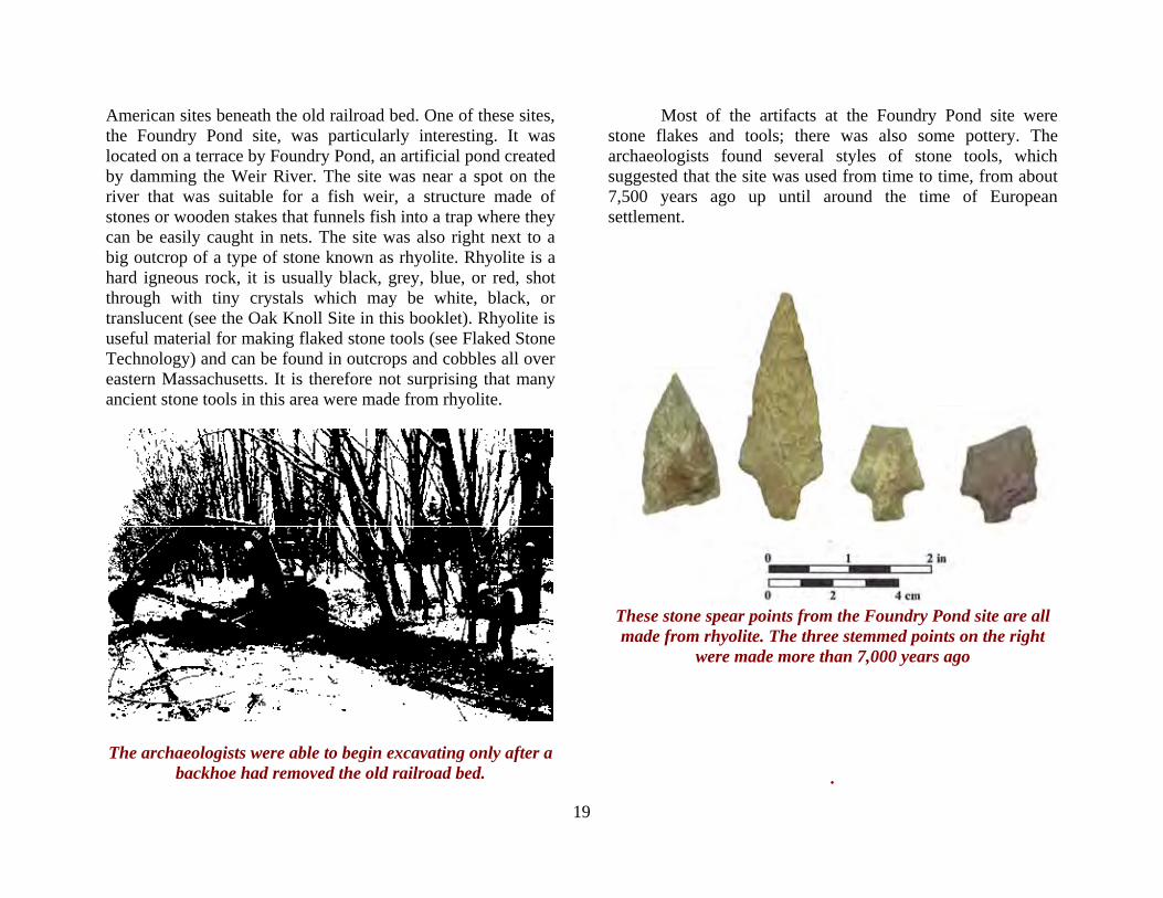
The archaeologists were able to begin excavating only after a backhoe had removed the old railroad bed.
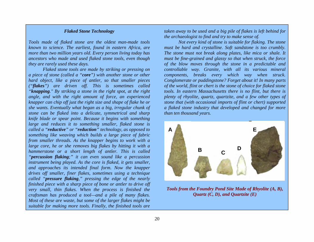
Most of the artifacts at the Foundry Pond site were stone flakes and tools; there was also some pottery. The archaeologists found several styles of stone tools, which suggested that the site was used from time to time, from about 7,500 years ago up until around the time of European settlement.
These stone spear points from the Foundry Pond site are all made from rhyolite. The three stemmed points on the right
were made more than 7,000 years ago .
20
Flaked Stone Technology
Tools made of flaked stone are the oldest man-made tools known to science. The earliest, found in eastern Africa, are more than two million years old. Every person living today has ancestors who made and used flaked stone tools, even though they are rarely used these days. Flaked stone tools are made by striking or pressing on a piece of stone (called a “core”) with another stone or other hard object, like a piece of antler, so that smaller pieces (“flakes”) are driven off. This is sometimes called “knapping." By striking a stone in the right spot, at the right angle, and with the right amount of force, an experienced knapper can chip off just the right size and shape of flake he or she wants. Eventually what began as a big, irregular chunk of stone can be flaked into a delicate, symmetrical and sharp knife blade or spear point. Because it begins with something large and reduces it to something smaller, flaked stone is called a “reductive” or “reduction” technology, as opposed to something like weaving which builds a large piece of fabric from smaller threads. As the knapper begins to work with a large core, he or she removes big flakes by hitting it with a hammerstone or a short length of antler. This is called “percussion flaking;” it can even sound like a percussion instrument being played. As the core is flaked, it gets smaller, and approaches its intended final form. Now the knapper drives off smaller, finer flakes, sometimes using a technique called “pressure flaking,” pressing the edge of the nearly finished piece with a sharp piece of bone or antler to drive off very small, thin flakes. When the process is finished the craftsman has produced a tool—and a pile of many flakes. Most of these are waste, but some of the larger flakes might be suitable for making more tools. Finally, the finished tools are
taken away to be used and a big pile of flakes is left behind for the archaeologist to find and try to make sense of. Not every kind of stone is suitable for flaking. The stone must be hard and crystalline. Soft sandstone is too crumbly. The stone must not break along plates, like mica or shale. It must be fine-grained and glassy so that when struck, the force of the blow moves through the stone in a predictable and controllable way. Granite, with all its various mineral components, breaks every which way when struck. Conglomerate or puddingstone? Forget about it! In many parts of the world, flint or chert is the stone of choice for flaked stone tools. In eastern Massachusetts there is no flint, but there is plenty of rhyolite, quartz, quartzite, and a few other types of stone that (with occasional imports of flint or chert) supported a flaked stone industry that developed and changed for more than ten thousand years.
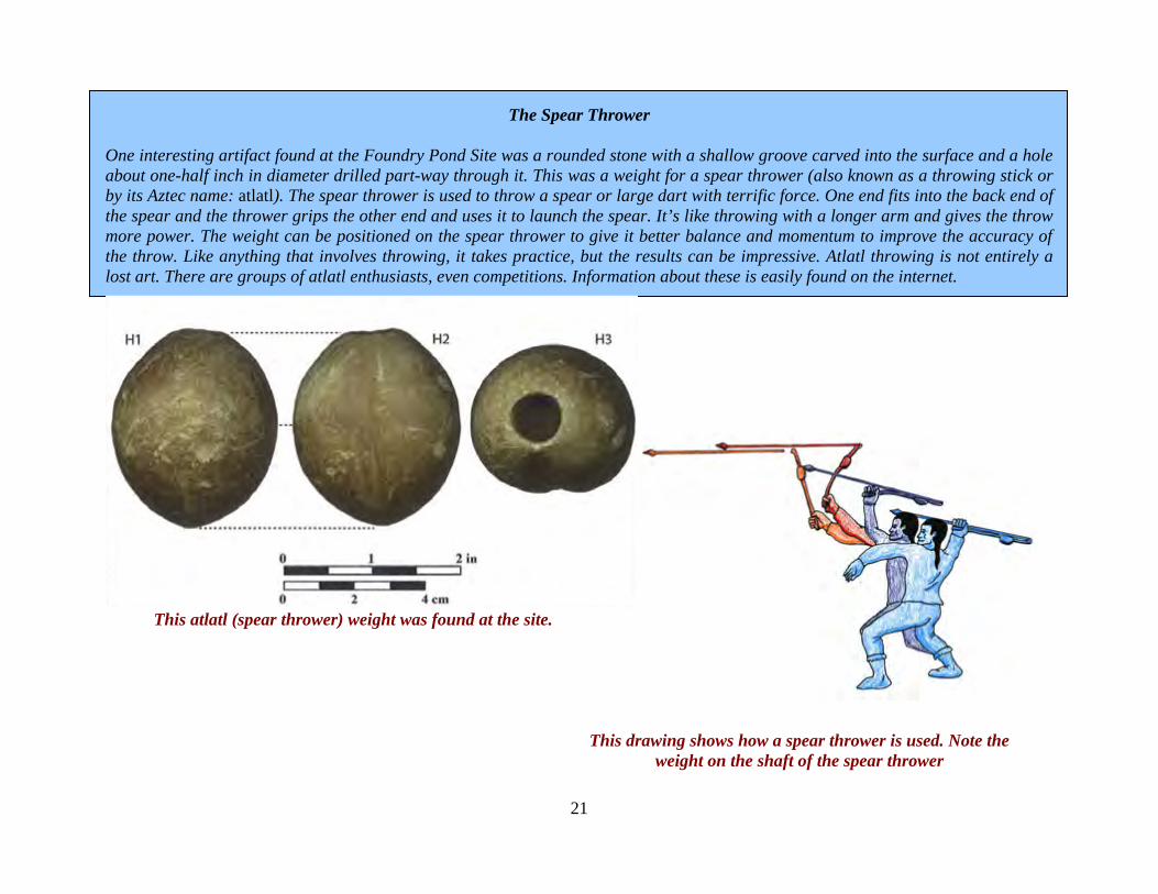
Tools from the Foundry Pond Site Made of Rhyolite (A, B),
Quartz (C, D), and Quartzite (E)
A
B C D
E
21
The Spear Thrower
One interesting artifact found at the Foundry Pond Site was a rounded stone with a shallow groove carved into the surface and a hole about one-half inch in diameter drilled part-way through it. This was a weight for a spear thrower (also known as a throwing stick or by its Aztec name: atlatl). The spear thrower is used to throw a spear or large dart with terrific force. One end fits into the back end of the spear and the thrower grips the other end and uses it to launch the spear. It’s like throwing with a longer arm and gives the throw more power. The weight can be positioned on the spear thrower to give it better balance and momentum to improve the accuracy of the throw. Like anything that involves throwing, it takes practice, but the results can be impressive. Atlatl throwing is not entirely a lost art. There are groups of atlatl enthusiasts, even competitions. Information about these is easily found on the internet.
This atlatl (spear thrower) weight was found at the site.
This drawing shows how a spear thrower is used. Note the weight on the shaft of the spear thrower
22
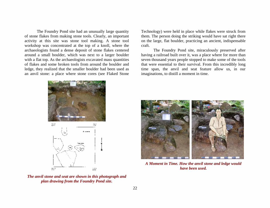
The Foundry Pond site had an unusually large quantity of stone flakes from making stone tools. Clearly, an important activity at this site was stone tool making. A stone tool workshop was concentrated at the top of a knoll, where the archaeologists found a dense deposit of stone flakes centered around a small boulder, which was next to a larger boulder with a flat top. As the archaeologists excavated mass quantities of flakes and some broken tools from around the boulder and ledge, they realized that the smaller boulder had been used as an anvil stone: a place where stone cores (see Flaked Stone
Technology) were held in place while flakes were struck from them. The person doing the striking would have sat right there on the large, flat boulder, practicing an ancient, indispensable craft. The Foundry Pond site, miraculously preserved after having a railroad built over it, was a place where for more than seven thousand years people stopped to make some of the tools that were essential to their survival. From this incredibly long time span, the anvil and seat feature allow us, in our imaginations, to distill a moment in time.
The anvil stone and seat are shown in this photograph and
plan drawing from the Foundry Pond site.
A Moment in Time. How the anvil stone and ledge would
have been used.
23
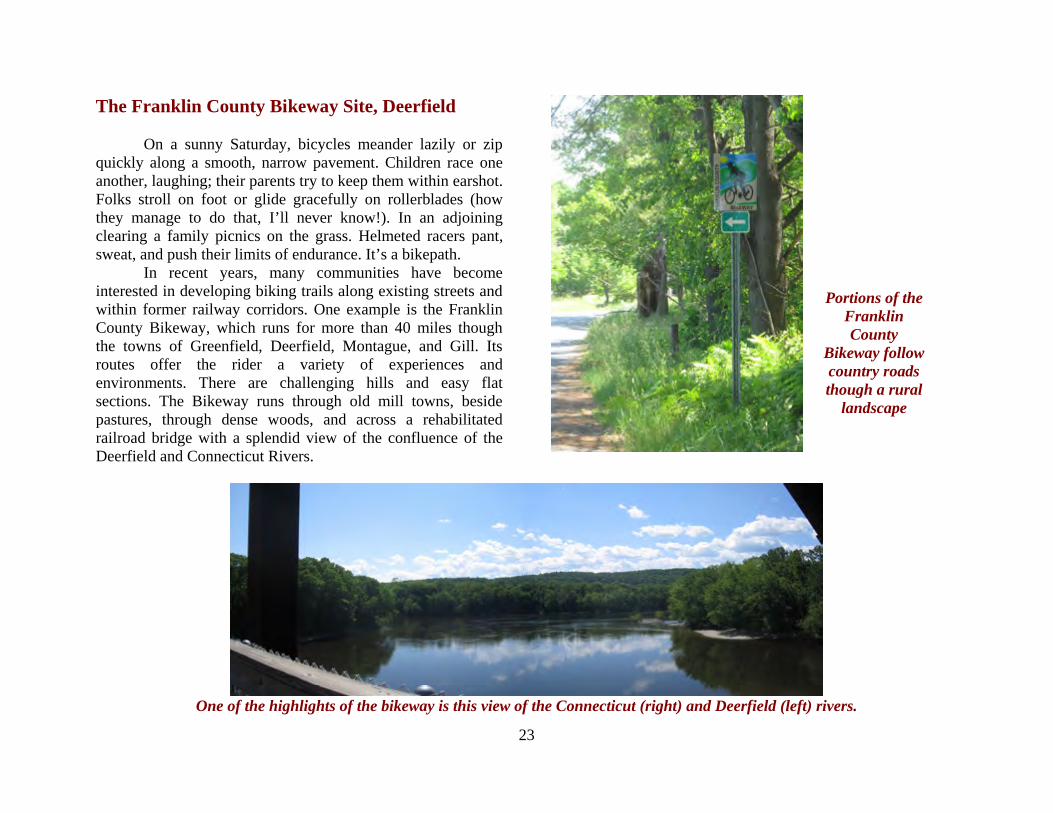
The Franklin County Bikeway Site, Deerfield On a sunny Saturday, bicycles meander lazily or zip quickly along a smooth, narrow pavement. Children race one another, laughing; their parents try to keep them within earshot. Folks stroll on foot or glide gracefully on rollerblades (how they manage to do that, I’ll never know!). In an adjoining clearing a family picnics on the grass. Helmeted racers pant, sweat, and push their limits of endurance. It’s a bikepath. In recent years, many communities have become interested in developing biking trails along existing streets and within former railway corridors. One example is the Franklin County Bikeway, which runs for more than 40 miles though the towns of Greenfield, Deerfield, Montague, and Gill. Its routes offer the rider a variety of experiences and environments. There are challenging hills and easy flat sections. The Bikeway runs through old mill towns, beside pastures, through dense woods, and across a rehabilitated railroad bridge with a splendid view of the confluence of the Deerfield and Connecticut Rivers.
One of the highlights of the bikeway is this view of the Connecticut (right) and Deerfield (left) rivers.
Portions of the Franklin County
Bikeway follow country roads though a rural
landscape

24
Creation of a bike path along existing streets and railroad beds often does not warrant archaeological investigation. That’s because these areas were disturbed when the roads and rails were built, and the new bike path does not require extensive rebuilding the way a new railroad or street would. In this case, a small section of new paving was needed to connect roadway with rail bed. This segment passed right through an area in Deerfield where amateur archaeologists had found Native American artifacts in the early twentieth century. In 2004, archaeologists from the Public Archaeology Laboratory, Inc. investigated this part of the proposed bikeway route and found an ancient archaeological site.
Deerfield, Massachusetts
This site, which was named after the bikepath, was small in size. It measured only about 30 feet by 24 feet. In this area, the archaeologists found a few dozen stone flakes—the byproducts of making or repairing stone tools. The most interesting find from the site was a pit-shaped feature. This pit contained some fire-reddened soil and charcoal, but it was not
chock full of charcoal and debris the way some features are. Because of this, and the site’s small size and limited range of artifacts, the archaeologists concluded that it was the product of a short stay by a small group, perhaps a single family overnight on a journey up or down one of the nearby rivers. But when did this trip happen?
This drawing of a cross-section, or “profile” through the feature shows that it had a darker color than the surrounding
soil and a shape something like a basin or bowl.
25
The archaeologists took samples of the charcoal and sent them to a laboratory for radiocarbon dating. The results of the analysis concluded that the pit was used around 3,200 years ago. This was a time archaeologists call the Late Archaic period. During this time, the Native people of New England lived by hunting, gathering, and fishing, moving their dwellings from season to season, based on their detailed knowledge of the land, its resources, and its seasonal changes.
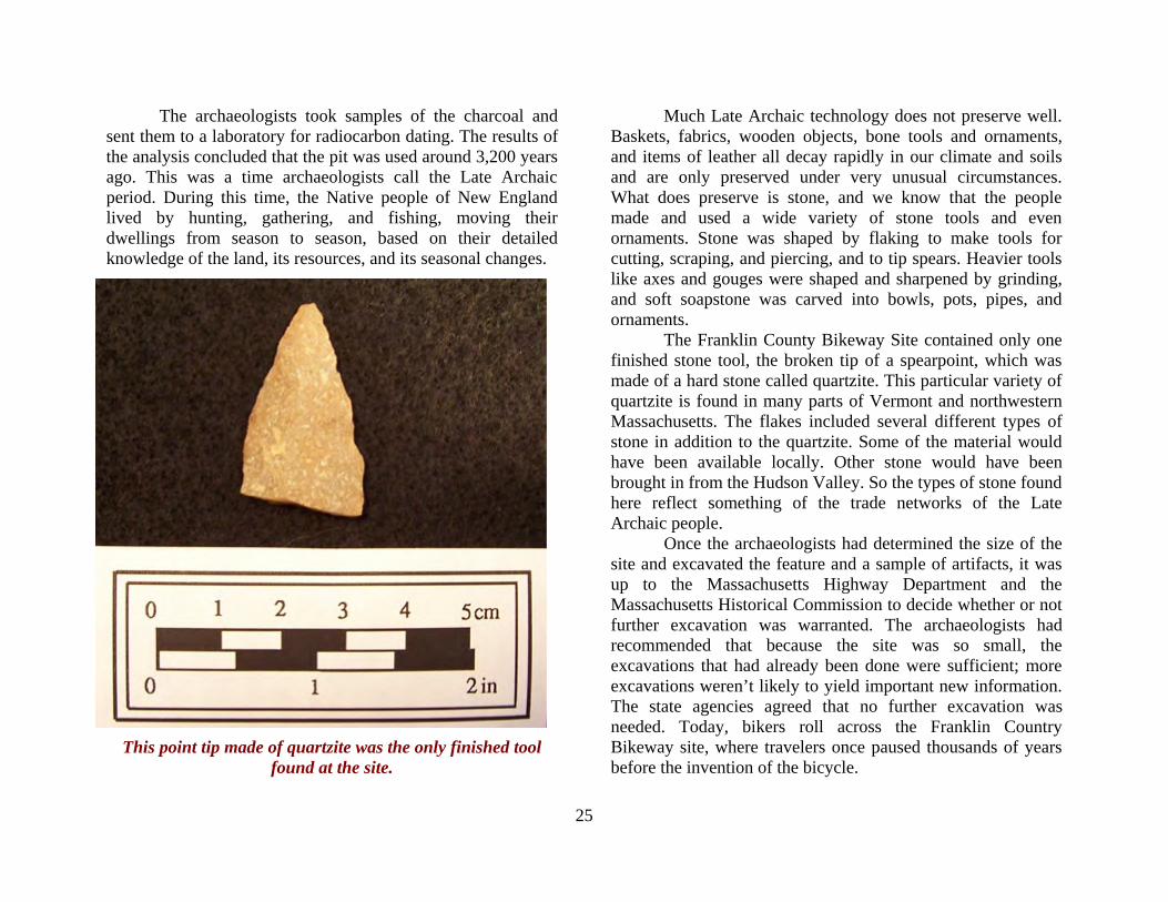
This point tip made of quartzite was the only finished tool found at the site.
Much Late Archaic technology does not preserve well. Baskets, fabrics, wooden objects, bone tools and ornaments, and items of leather all decay rapidly in our climate and soils and are only preserved under very unusual circumstances. What does preserve is stone, and we know that the people made and used a wide variety of stone tools and even ornaments. Stone was shaped by flaking to make tools for cutting, scraping, and piercing, and to tip spears. Heavier tools like axes and gouges were shaped and sharpened by grinding, and soft soapstone was carved into bowls, pots, pipes, and ornaments. The Franklin County Bikeway Site contained only one finished stone tool, the broken tip of a spearpoint, which was made of a hard stone called quartzite. This particular variety of quartzite is found in many parts of Vermont and northwestern Massachusetts. The flakes included several different types of stone in addition to the quartzite. Some of the material would have been available locally. Other stone would have been brought in from the Hudson Valley. So the types of stone found here reflect something of the trade networks of the Late Archaic people. Once the archaeologists had determined the size of the site and excavated the feature and a sample of artifacts, it was up to the Massachusetts Highway Department and the Massachusetts Historical Commission to decide whether or not further excavation was warranted. The archaeologists had recommended that because the site was so small, the excavations that had already been done were sufficient; more excavations weren’t likely to yield important new information. The state agencies agreed that no further excavation was needed. Today, bikers roll across the Franklin Country Bikeway site, where travelers once paused thousands of years before the invention of the bicycle.
26
Radiocarbon dating Radiocarbon dating was developed in the late 1940s. It is a valuable tool for archaeologists because it can tell them how old something is in years. Radiocarbon dating is based on the decay of a rare radioactive form of carbon known as “carbon 14.” Carbon is one of the most common elements in the earth, and is an important part of all living things, but carbon 14 makes up only a very small amount of the world’s total carbon. It forms high in the upper atmosphere where high-energy cosmic rays hit atoms of nitrogen gas and change them into radioactive carbon 14. Like all radioactive materials, carbon 14 is unstable; it decays, giving off a small amount of radiation in the process, and turning back into a more stable element (unstable carbon 14 becomes stable nitrogen). Living things take carbon (including carbon 14) into their bodies by eating or, in the case of plants, by photosynthesis. When a living thing dies, it stops taking in new carbon, and its radioactive carbon 14 begins to decay. The important thing is that carbon 14 decays at a known, constant rate. This rate is known as a half-life; it is the amount of time it takes for half of any given amount of carbon 14 to decay. All radioactive materials have a half-life. For some it is measured in seconds; for others, it takes millions of years. The half-life of carbon 14 is 5,730 years. Scientists use this known, constant rate of decay like a clock. By measuring the amount of carbon 14 remaining in a sample of charcoal or other once-living material, they can accurately estimate when that material stopped living. Because of the way it works, radiocarbon dating can only be used on material from things that were once alive. Archaeologists often choose wood charcoal (from once-living trees) found in ancient cooking fires for dating. Also, because it takes "only" 5,730 years for half the carbon 14 to disappear, after about 50,000 years there isn't enough of the material left to measure accurately. So stone tools (which were never alive) and dinosaur fossils (which are millions of years old) cannot be dated using this method. If an archaeologist wants to use radiocarbon dating, he or she must find material with carbon in it (charcoal, which is nearly pure carbon, is ideal) that is clearly connected with the activities the archaeologist wants to date. Since charcoal from a feature like the pit in the Franklin County Bikeway site is most closely connected with the other stuff in the pit, the radiocarbon date for that piece of charcoal is probably also the date for everything else—including other artifacts—that was found in the pit. It is a little less securely connected in time with any other features or artifacts at the site, especially if the site is a large one that was occupied over many centuries. A radiocarbon date from a piece of charcoal, a bone, or other once-living material that is not clearly associated with any artifacts or features at a site (and by extension, to the human actions that created them) is worthless. So archaeologists must be very careful in choosing the samples they want to date and cautious in saying what their radiocarbon dates are actually dating. .
27
THE POLPIS ROAD BICYCLE PATH SITES, NANTUCKET
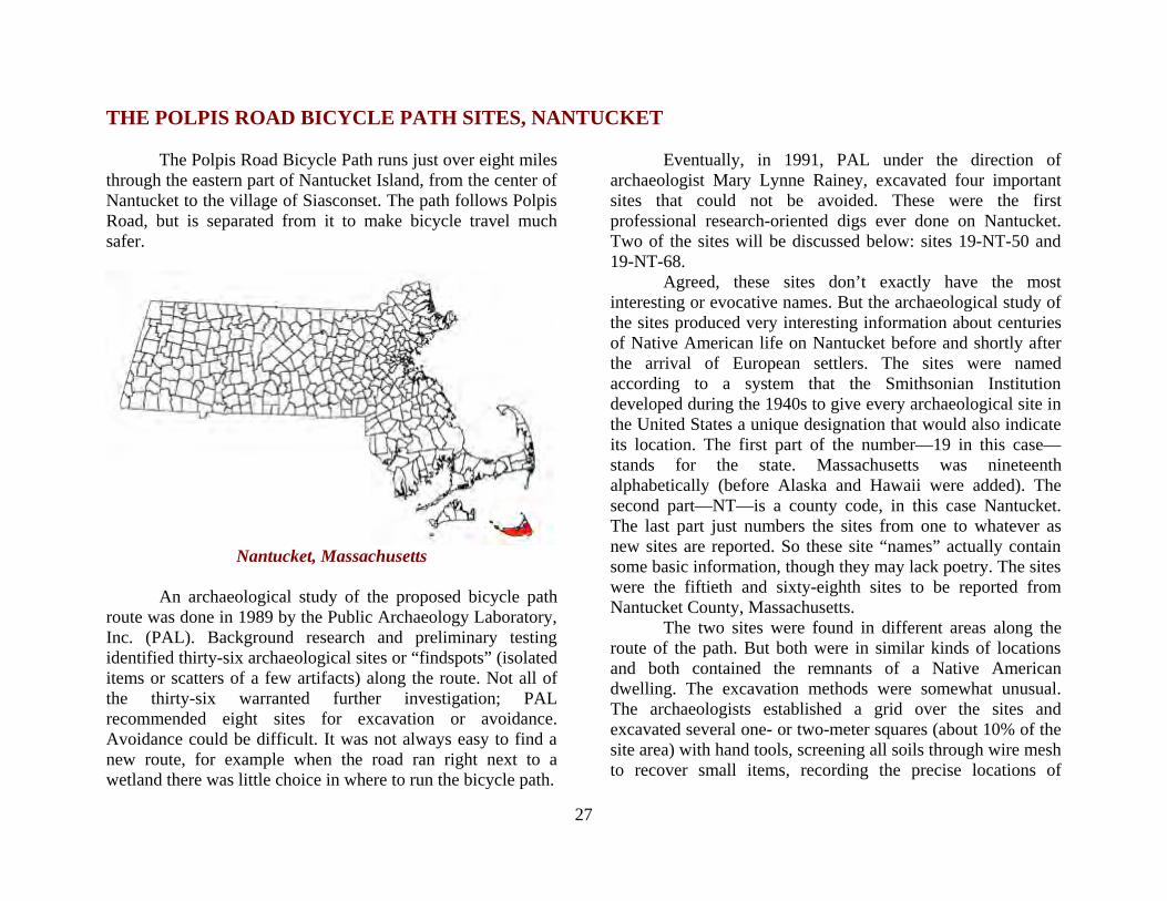
The Polpis Road Bicycle Path runs just over eight miles through the eastern part of Nantucket Island, from the center of Nantucket to the village of Siasconset. The path follows Polpis Road, but is separated from it to make bicycle travel much safer.
Nantucket, Massachusetts
An archaeological study of the proposed bicycle path
route was done in 1989 by the Public Archaeology Laboratory, Inc. (PAL). Background research and preliminary testing identified thirty-six archaeological sites or “findspots” (isolated items or scatters of a few artifacts) along the route. Not all of the thirty-six warranted further investigation; PAL recommended eight sites for excavation or avoidance. Avoidance could be difficult. It was not always easy to find a new route, for example when the road ran right next to a wetland there was little choice in where to run the bicycle path.
Eventually, in 1991, PAL under the direction of
archaeologist Mary Lynne Rainey, excavated four important sites that could not be avoided. These were the first professional research-oriented digs ever done on Nantucket. Two of the sites will be discussed below: sites 19-NT-50 and 19-NT-68.
Agreed, these sites don’t exactly have the most interesting or evocative names. But the archaeological study of the sites produced very interesting information about centuries of Native American life on Nantucket before and shortly after the arrival of European settlers. The sites were named according to a system that the Smithsonian Institution developed during the 1940s to give every archaeological site in the United States a unique designation that would also indicate its location. The first part of the number—19 in this case—stands for the state. Massachusetts was nineteenth alphabetically (before Alaska and Hawaii were added). The second part—NT—is a county code, in this case Nantucket. The last part just numbers the sites from one to whatever as new sites are reported. So these site “names” actually contain some basic information, though they may lack poetry. The sites were the fiftieth and sixty-eighth sites to be reported from Nantucket County, Massachusetts.
The two sites were found in different areas along the route of the path. But both were in similar kinds of locations and both contained the remnants of a Native American dwelling. The excavation methods were somewhat unusual. The archaeologists established a grid over the sites and excavated several one- or two-meter squares (about 10% of the site area) with hand tools, screening all soils through wire mesh to recover small items, recording the precise locations of
28
When Unmarked Graves are Encountered It sometimes happens that unmarked human graves are found. This usually occurs during ordinary ground disturbing activities like excavating foundations for homes, digging trenches for utility lines, or grading for roads. Massachusetts laws have established procedures to follow when human bones are accidentally uncovered. If you should discover bones, do not touch or disturb them. If construction is going on near the bones it must be stopped immediately. Notify the state or local police and the Chief Medical Examiner about the discovery and the location. The medical examiner will determine whether the bones are human and whether they are recent or more than 100 years old. If they are recent the burial may be a crime scene and require a police investigation. If they are more than 100 years old the medical examiner contacts the Massachusetts State Archaeologist, who will conduct an archaeological investigation while the police make sure that the grave site is protected from further disturbance. If the State Archaeologist determines that the burial is that of a Native American, the Massachusetts Commission on Indian Affairs is notified and monitors the archaeological investigation to make sure that the remains are treated respectfully. The State Archaeologist and the Commission on Indian Affairs consult with the landowner to determine whether the burial can remain where it is, undisturbed and protected from future disturbance. Often this can be accomplished, but if it appears impossible to avoid future harm to the burial the State Archaeologist may remove the remains with the consent of the Commission on Indian Affairs. The Commission on Indian Affairs sees to it that the remains are reburied in a protected location by the appropriate Native American tribe.
artifacts and features, and taking samples of soil for further processing in the laboratory. After this excavation was complete, the remainder of the site was stripped of topsoil using a backhoe, and the archaeologists carefully cleaned and inspected the revealed subsoil surface to identify features. They especially wanted to make sure that any unmarked graves that might be near the sites would not be disturbed when the bicycle path was built. It is often easy to identify grave shafts once the topsoil has been removed. The graves are filled in with a mixture of topsoil and subsoil, which have different colors and produce a mottled, mixed fill, while the surrounding, undisturbed soil is much more uniform in color and texture. Looking down on the stripped area, it is not hard to see the grave-shaped outline in the subsoil. Fortunately, no burials were disturbed in the making of the Polpis Road bicycle path.
If unmarked graves are inadvertently found during construction there are laws and procedures in place to insure that they are treated with respect and are avoided if at all possible (see When Unmarked Graves Are Encountered).
What was found at both of the sites was the location of an identifiable Native American dwelling. Recognizable archaeological traces of Native American dwellings, known as wetus or wigwams are very rarely found in Massachusetts. There are a number of reasons for this. First, wigwams were made from a framework of poles covered with woven mats or sheets of bark. They did not include stone foundations, brick chimneys, or cellar holes, so their archaeological "signature" is not highly visible. Many if not most were not set up in one place for years at a time. They could be, and often were, taken down, moved to a new place, and set up again—the original

29
New England mobile home. Even if people returned year after year to the same place, they might not set up their dwelling in precisely the same spot, and the archaeological result is a confusing mass of postmolds, artifacts, and features, often made even more difficult to interpret when the site has been disturbed by plowing, as is very common in Massachusetts sites, and when the “window” through which the archaeologists view the site consists of a couple of one-meter squares.
Evidence of these dwellings was a remarkable find! They appeared as large areas of black organic-rich soil. This soil deposit, as much as a foot thick in places, was loaded with artifacts, including stone tools and flakes, ceramic sherds, and fragments of bone and shell. Outside the limits of the dwelling there were far fewer artifacts. The dwellings contained archaeological features including fire hearths and many post molds, some large and many small.
You can see the pole framework (left) and bark covering (right) of this wigwam or wetu built by Native American artist Jeff Kalim.
Woven mats could also be used to cover the framework.
30
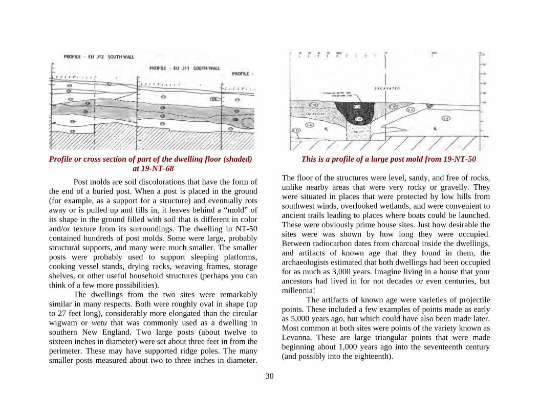
Profile or cross section of part of the dwelling floor (shaded) This is a profile of a large post mold from 19-NT-50 at 19-NT-68
Post molds are soil discolorations that have the form of the end of a buried post. When a post is placed in the ground (for example, as a support for a structure) and eventually rots away or is pulled up and fills in, it leaves behind a “mold” of its shape in the ground filled with soil that is different in color and/or texture from its surroundings. The dwelling in NT-50 contained hundreds of post molds. Some were large, probably structural supports, and many were much smaller. The smaller posts were probably used to support sleeping platforms, cooking vessel stands, drying racks, weaving frames, storage shelves, or other useful household structures (perhaps you can think of a few more possibilities).
The dwellings from the two sites were remarkably similar in many respects. Both were roughly oval in shape (up to 27 feet long), considerably more elongated than the circular wigwam or wetu that was commonly used as a dwelling in southern New England. Two large posts (about twelve to sixteen inches in diameter) were set about three feet in from the perimeter. These may have supported ridge poles. The many smaller posts measured about two to three inches in diameter.
The floor of the structures were level, sandy, and free of rocks, unlike nearby areas that were very rocky or gravelly. They were situated in places that were protected by low hills from southwest winds, overlooked wetlands, and were convenient to ancient trails leading to places where boats could be launched. These were obviously prime house sites. Just how desirable the sites were was shown by how long they were occupied. Between radiocarbon dates from charcoal inside the dwellings, and artifacts of known age that they found in them, the archaeologists estimated that both dwellings had been occupied for as much as 3,000 years. Imagine living in a house that your ancestors had lived in for not decades or even centuries, but millennia!
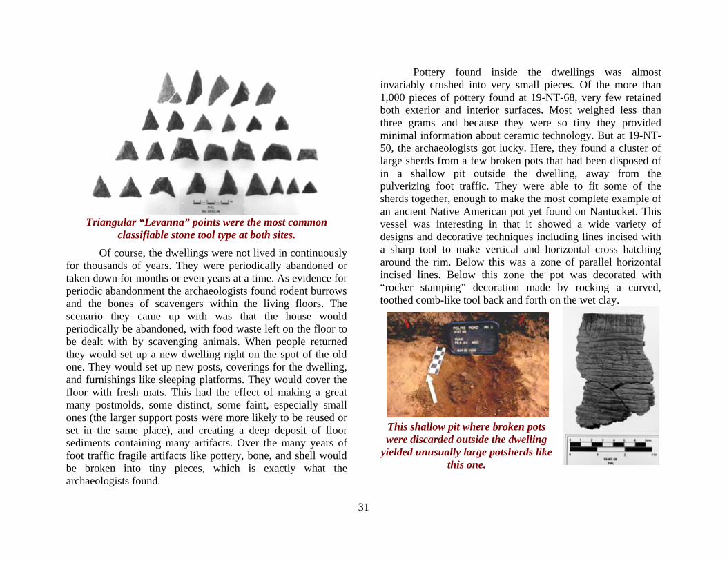
The artifacts of known age were varieties of projectile points. These included a few examples of points made as early as 5,000 years ago, but which could have also been made later. Most common at both sites were points of the variety known as Levanna. These are large triangular points that were made beginning about 1,000 years ago into the seventeenth century (and possibly into the eighteenth).
31
Triangular “Levanna” points were the most common
classifiable stone tool type at both sites. Of course, the dwellings were not lived in continuously
for thousands of years. They were periodically abandoned or taken down for months or even years at a time. As evidence for periodic abandonment the archaeologists found rodent burrows and the bones of scavengers within the living floors. The scenario they came up with was that the house would periodically be abandoned, with food waste left on the floor to be dealt with by scavenging animals. When people returned they would set up a new dwelling right on the spot of the old one. They would set up new posts, coverings for the dwelling, and furnishings like sleeping platforms. They would cover the floor with fresh mats. This had the effect of making a great many postmolds, some distinct, some faint, especially small ones (the larger support posts were more likely to be reused or set in the same place), and creating a deep deposit of floor sediments containing many artifacts. Over the many years of foot traffic fragile artifacts like pottery, bone, and shell would be broken into tiny pieces, which is exactly what the archaeologists found.
Pottery found inside the dwellings was almost invariably crushed into very small pieces. Of the more than 1,000 pieces of pottery found at 19-NT-68, very few retained both exterior and interior surfaces. Most weighed less than three grams and because they were so tiny they provided minimal information about ceramic technology. But at 19-NT-50, the archaeologists got lucky. Here, they found a cluster of large sherds from a few broken pots that had been disposed of in a shallow pit outside the dwelling, away from the pulverizing foot traffic. They were able to fit some of the sherds together, enough to make the most complete example of an ancient Native American pot yet found on Nantucket. This vessel was interesting in that it showed a wide variety of designs and decorative techniques including lines incised with a sharp tool to make vertical and horizontal cross hatching around the rim. Below this was a zone of parallel horizontal incised lines. Below this zone the pot was decorated with “rocker stamping” decoration made by rocking a curved, toothed comb-like tool back and forth on the wet clay.
This shallow pit where broken pots were discarded outside the dwelling
yielded unusually large potsherds like this one.
32
Bone was found in abundance inside the dwellings. The archaeologists recovered more than 5,000 bones, mostly tiny fragments, from 19-NT-50, and nearly 9,000 were found in 19-NT-68. They found most of the fine pieces of bone using a method called “flotation." In this procedure, soil samples taken from a site are added to water; lightweight organic material such as tiny bones and seeds float and are skimmed off the top. Because of their highly fragmented state only about 5% of the bone bits could be identified as to species.
The species that were identified were an interesting mix of marine and terrestrial animals. White tailed deer was the most common, although their importance might be overestimated somewhat because they have large, easily identified teeth (teeth with their hard enamel surfaces preserve better than other bones). But it was interesting that among a people known for their fishing and whaling prowess, deer should be the single most common species represented in the bones. Certainly the Native people of Nantucket could do more than just fish. There were plenty of fish and marine mammals identified as well, including cod, tautog, seal, dogfish, and sturgeon. Other animals from land or fresh water included raccoon, river otter, turtle and muskrat. In the dwelling at NT-68 were the bones of animals of European origin: cow, pig, and sheep/goat (a term archaeologists use because sheep and goat bones are almost indistinguishable). These remains, as well as a few pieces of ceramics of English origin, and radiocarbon dates, strongly suggest that this dwelling was occupied after the English first settled the island in 1659.
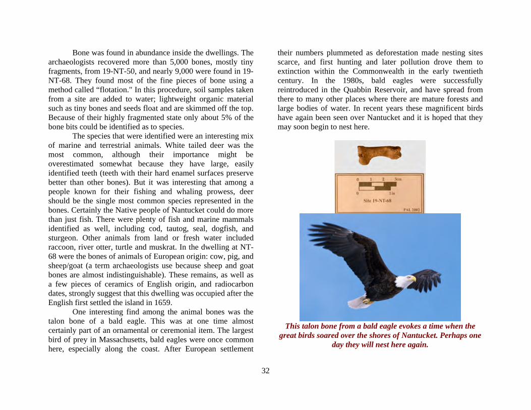
One interesting find among the animal bones was the talon bone of a bald eagle. This was at one time almost certainly part of an ornamental or ceremonial item. The largest bird of prey in Massachusetts, bald eagles were once common here, especially along the coast. After European settlement
their numbers plummeted as deforestation made nesting sites scarce, and first hunting and later pollution drove them to extinction within the Commonwealth in the early twentieth century. In the 1980s, bald eagles were successfully reintroduced in the Quabbin Reservoir, and have spread from there to many other places where there are mature forests and large bodies of water. In recent years these magnificent birds have again been seen over Nantucket and it is hoped that they may soon begin to nest here.
This talon bone from a bald eagle evokes a time when the
great birds soared over the shores of Nantucket. Perhaps one day they will nest here again.

33
The flotation procedure was originally developed to recover seeds from archaeological sites, and many were recovered from 19-NT-50 and 19-NT-68. Among the most important seed finds were fragments of maize. These were radiocarbon dated to the time just before and a bit after first contact with Europeans. Although only a few kernels were found, these were the first radiocarbon dates for maize on Nantucket.
This tiny carbonized kernel of maize from 19-NT-50 was
harvested sometime between 1440 and 1630 AD.
Of course there were shellfish here too. Crunched into tiny fragments under the feet of generations, more than 2,000 shell fragments were extracted by the archaeologists. Quahog was the most common, both by numbers of fragments and total weight, followed by oyster, soft-shell clam (“steamers”), and scallops. Because certain animals only occur in certain places at certain times of the year, by identifying the types of animals at an archaeological site archaeologists can learn what time(s) of the year the site was occupied. Some of the fish species from
NT-68 (dusky shark, spiny dogfish, and sturgeon) are taken from late spring to early fall; other marine species (cod and grey seal) are available from winter to early spring. Overall, this suggests that the site may have been occupied year-round, or sometimes one part of the year and sometimes another. Maybe there was a change over time. But change over time was impossible to track at these sites because the living floor of the dwelling was disturbed by the setting and removing of posts, the activities of animal burrowers, and the trampling of artifacts into the soil. These activities mixed and stirred any distinct layers representing individual occupations; finding such layers would be an archaeologists dream! The PAL archaeologists would have to be content with the finding of not one but two unprecedented Massachusetts sites that evoked a remarkable continuity of life and home.
The people who lived at these sites fished and hunted seals in the teeming waters of Nantucket Sound.
Atlantic Sturgeon
Grey Seal
34
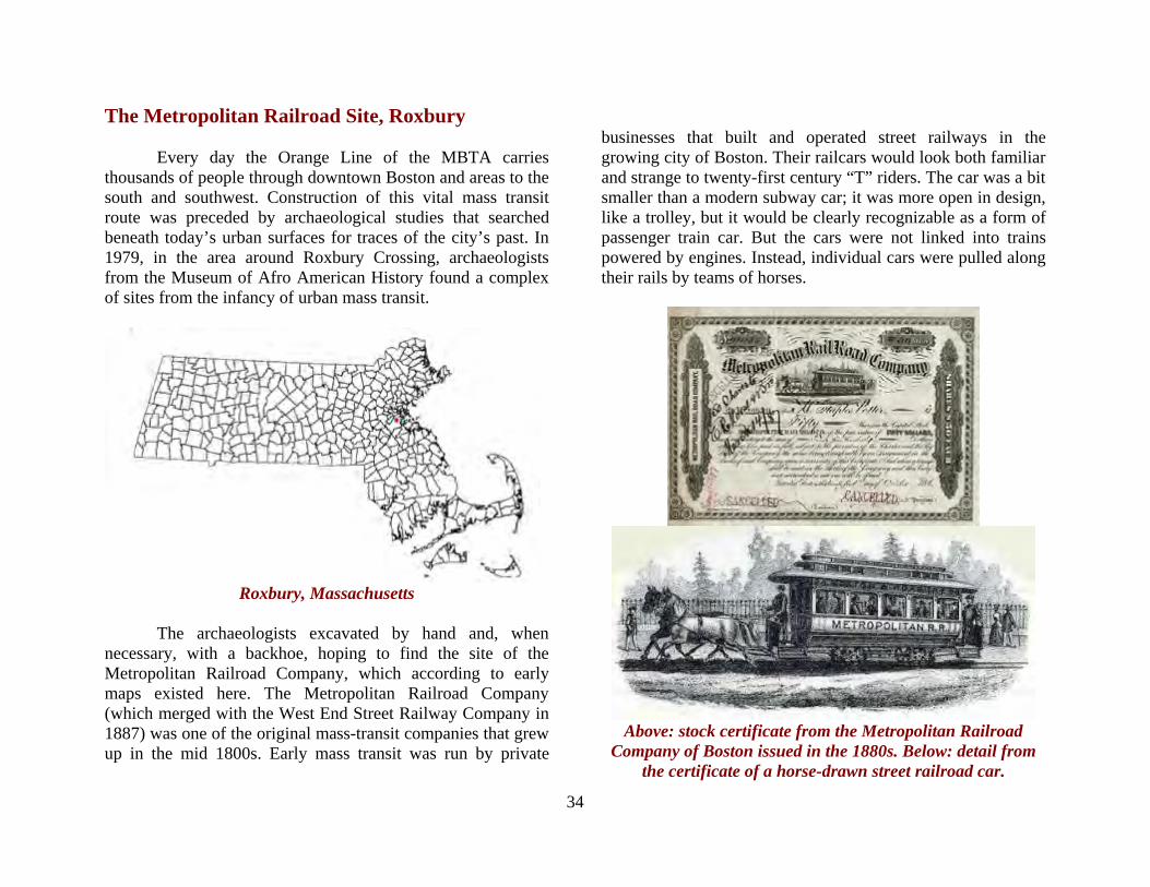
The Metropolitan Railroad Site, Roxbury Every day the Orange Line of the MBTA carries thousands of people through downtown Boston and areas to the south and southwest. Construction of this vital mass transit route was preceded by archaeological studies that searched beneath today’s urban surfaces for traces of the city’s past. In 1979, in the area around Roxbury Crossing, archaeologists from the Museum of Afro American History found a complex of sites from the infancy of urban mass transit.
Roxbury, Massachusetts
The archaeologists excavated by hand and, when necessary, with a backhoe, hoping to find the site of the Metropolitan Railroad Company, which according to early maps existed here. The Metropolitan Railroad Company (which merged with the West End Street Railway Company in 1887) was one of the original mass-transit companies that grew up in the mid 1800s. Early mass transit was run by private
businesses that built and operated street railways in the growing city of Boston. Their railcars would look both familiar and strange to twenty-first century “T” riders. The car was a bit smaller than a modern subway car; it was more open in design, like a trolley, but it would be clearly recognizable as a form of passenger train car. But the cars were not linked into trains powered by engines. Instead, individual cars were pulled along their rails by teams of horses.
Above: stock certificate from the Metropolitan Railroad
Company of Boston issued in the 1880s. Below: detail from the certificate of a horse-drawn street railroad car.
35
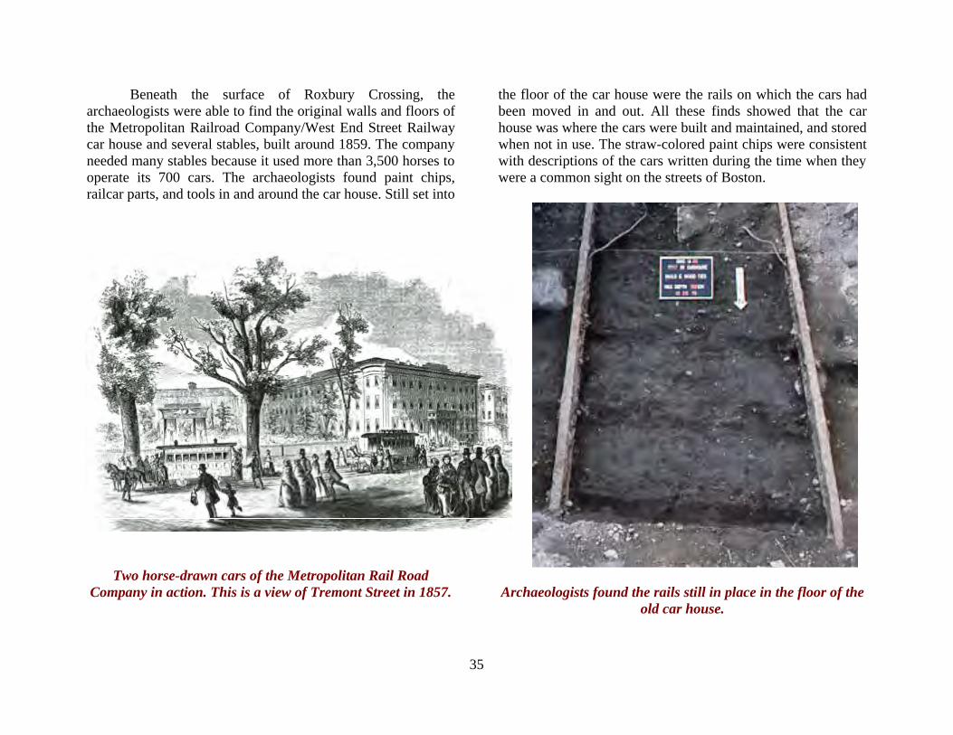
Beneath the surface of Roxbury Crossing, the archaeologists were able to find the original walls and floors of the Metropolitan Railroad Company/West End Street Railway car house and several stables, built around 1859. The company needed many stables because it used more than 3,500 horses to operate its 700 cars. The archaeologists found paint chips, railcar parts, and tools in and around the car house. Still set into
the floor of the car house were the rails on which the cars had been moved in and out. All these finds showed that the car house was where the cars were built and maintained, and stored when not in use. The straw-colored paint chips were consistent with descriptions of the cars written during the time when they were a common sight on the streets of Boston.
Two horse-drawn cars of the Metropolitan Rail Road Company in action. This is a view of Tremont Street in 1857.
Archaeologists found the rails still in place in the floor of the
old car house.
36
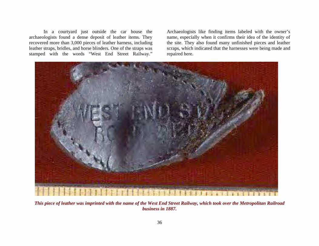
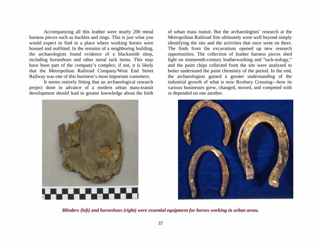
In a courtyard just outside the car house the archaeologists found a dense deposit of leather items. They recovered more than 3,000 pieces of leather harness, including leather straps, bridles, and horse blinders. One of the straps was stamped with the words “West End Street Railway.”
Archaeologists like finding items labeled with the owner’s name, especially when it confirms their idea of the identity of the site. They also found many unfinished pieces and leather scraps, which indicated that the harnesses were being made and repaired here.
This piece of leather was imprinted with the name of the West End Street Railway, which took over the Metropolitan Railroad business in 1887.
37
Accompanying all this leather were nearly 200 metal harness pieces such as buckles and rings. This is just what you would expect to find in a place where working horses were housed and outfitted. In the remains of a neighboring building, the archaeologists found evidence of a blacksmith shop, including horseshoes and other metal tack items. This may have been part of the company’s complex; if not, it is likely that the Metropolitan Railroad Company/West End Street Railway was one of this business’s most important customers. It seems entirely fitting that an archaeological research project done in advance of a modern urban mass-transit development should lead to greater knowledge about the birth
of urban mass transit. But the archaeologists’ research at the Metropolitan Railroad Site ultimately went well beyond simply identifying the site and the activities that once went on there. The finds from the excavations opened up new research opportunities. The collection of leather harness pieces shed light on nineteenth-century leatherworking and “tack-nology,” and the paint chips collected from the site were analyzed to better understand the paint chemistry of the period. In the end, the archaeologists gained a greater understanding of the industrial growth of what is now Roxbury Crossing—how its various businesses grew, changed, moved, and competed with or depended on one another.
Blinders (left) and horseshoes (right) were essential equipment for horses working in urban areas.

38
THE HIGHLAND FOUNDRY SITE, ROXBURY Not far from the Metropolitan Railroad Site was the Highland Foundry Site, which was also discovered and studied by archaeologists from the Museum of Afro American History working in advance of the Orange Line expansion in 1979 and 1980. The archaeologists excavated large portions of the foundry's furnace area, where scrap iron or iron ore was smelted to make molten iron, and the molding room, where the liquid metal was poured into sand molds to make cast iron pots,
pans, kettles, stoves, fire grates, and other items. With the results of these excavations, research into documents and maps, and even a visit to a working cast iron stove factory in Maine, the archaeologists were able to tell the story of how the kinds of products made at the Highland Foundry were determined by the needs and demands of the community, and how the changing structure and layout of the factory reflected the changing urban environment of nineteenth-century Roxbury.
This 1914 plan of the Highland Foundry shows the Cupola as a small circle (the cupola is the kind of furnace they used to smelt the iron) and two “moulding” rooms where the molten iron was poured into molds of compacted and treated sand. Much of the
archaeological excavation was done around the cupola and the moulding room just to the right of the cupola.
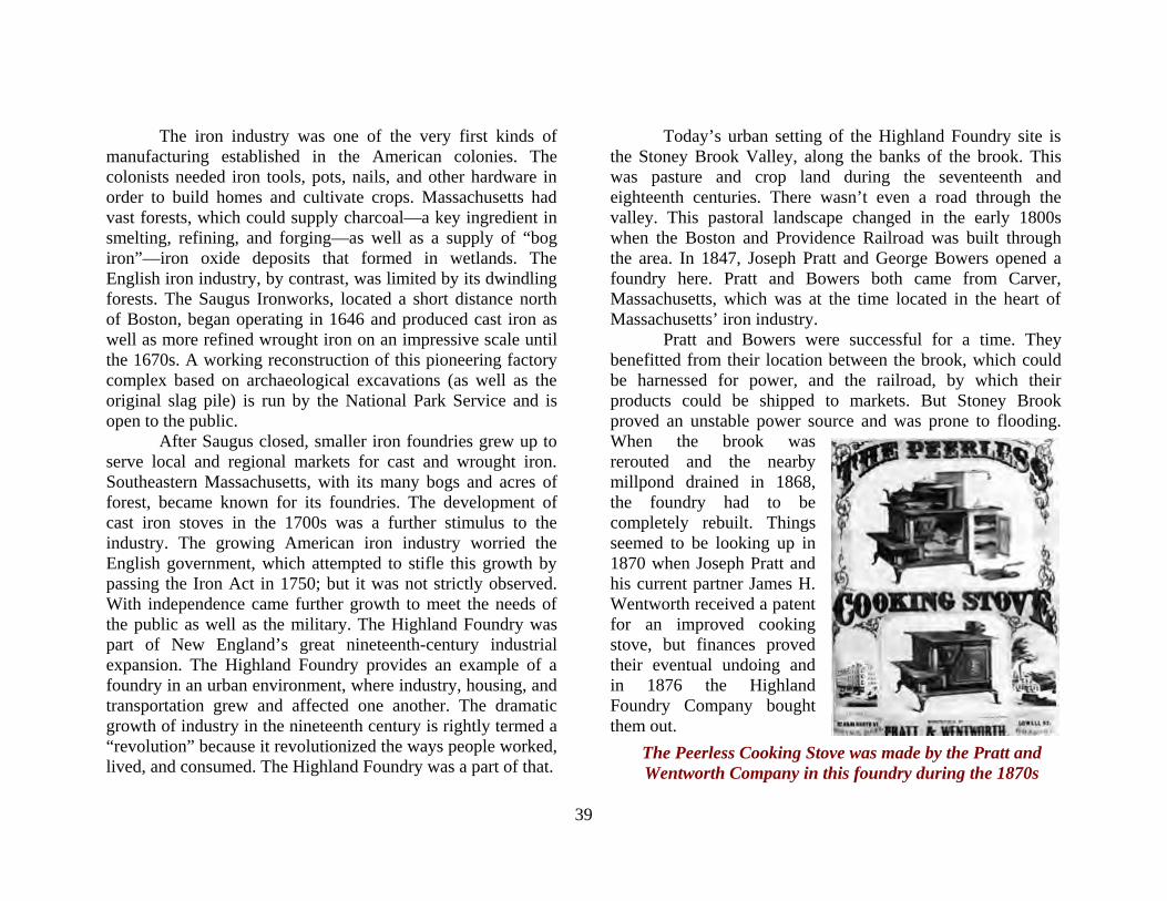
39
The Peerless Cooking Stove was made by the Pratt and Wentworth Company in this foundry during the 1870s
The iron industry was one of the very first kinds of manufacturing established in the American colonies. The colonists needed iron tools, pots, nails, and other hardware in order to build homes and cultivate crops. Massachusetts had vast forests, which could supply charcoal—a key ingredient in smelting, refining, and forging—as well as a supply of “bog iron”—iron oxide deposits that formed in wetlands. The English iron industry, by contrast, was limited by its dwindling forests. The Saugus Ironworks, located a short distance north of Boston, began operating in 1646 and produced cast iron as well as more refined wrought iron on an impressive scale until the 1670s. A working reconstruction of this pioneering factory complex based on archaeological excavations (as well as the original slag pile) is run by the National Park Service and is open to the public. After Saugus closed, smaller iron foundries grew up to serve local and regional markets for cast and wrought iron. Southeastern Massachusetts, with its many bogs and acres of forest, became known for its foundries. The development of cast iron stoves in the 1700s was a further stimulus to the industry. The growing American iron industry worried the English government, which attempted to stifle this growth by passing the Iron Act in 1750; but it was not strictly observed. With independence came further growth to meet the needs of the public as well as the military. The Highland Foundry was part of New England’s great nineteenth-century industrial expansion. The Highland Foundry provides an example of a foundry in an urban environment, where industry, housing, and transportation grew and affected one another. The dramatic growth of industry in the nineteenth century is rightly termed a “revolution” because it revolutionized the ways people worked, lived, and consumed. The Highland Foundry was a part of that.
Today’s urban setting of the Highland Foundry site is the Stoney Brook Valley, along the banks of the brook. This was pasture and crop land during the seventeenth and eighteenth centuries. There wasn’t even a road through the valley. This pastoral landscape changed in the early 1800s when the Boston and Providence Railroad was built through the area. In 1847, Joseph Pratt and George Bowers opened a foundry here. Pratt and Bowers both came from Carver, Massachusetts, which was at the time located in the heart of Massachusetts’ iron industry. Pratt and Bowers were successful for a time. They benefitted from their location between the brook, which could be harnessed for power, and the railroad, by which their products could be shipped to markets. But Stoney Brook proved an unstable power source and was prone to flooding. When the brook was rerouted and the nearby millpond drained in 1868, the foundry had to be completely rebuilt. Things seemed to be looking up in 1870 when Joseph Pratt and his current partner James H. Wentworth received a patent for an improved cooking stove, but finances proved their eventual undoing and in 1876 the Highland Foundry Company bought them out.
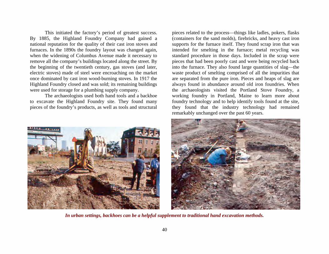
40
This initiated the factory’s period of greatest success. By 1885, the Highland Foundry Company had gained a national reputation for the quality of their cast iron stoves and furnaces. In the 1890s the foundry layout was changed again, when the widening of Columbus Avenue made it necessary to remove all the company’s buildings located along the street. By the beginning of the twentieth century, gas stoves (and later, electric stoves) made of steel were encroaching on the market once dominated by cast iron wood-burning stoves. In 1917 the Highland Foundry closed and was sold; its remaining buildings were used for storage for a plumbing supply company. The archaeologists used both hand tools and a backhoe to excavate the Highland Foundry site. They found many pieces of the foundry’s products, as well as tools and structural
pieces related to the process—things like ladles, pokers, flasks (containers for the sand molds), firebricks, and heavy cast iron supports for the furnace itself. They found scrap iron that was intended for smelting in the furnace; metal recycling was standard procedure in those days. Included in the scrap were pieces that had been poorly cast and were being recycled back into the furnace. They also found large quantities of slag—the waste product of smelting comprised of all the impurities that are separated from the pure iron. Pieces and heaps of slag are always found in abundance around old iron foundries. When the archaeologists visited the Portland Stove Foundry, a working foundry in Portland, Maine to learn more about foundry technology and to help identify tools found at the site, they found that the industry technology had remained remarkably unchanged over the past 60 years.
In urban settings, backhoes can be a helpful supplement to traditional hand excavation methods.
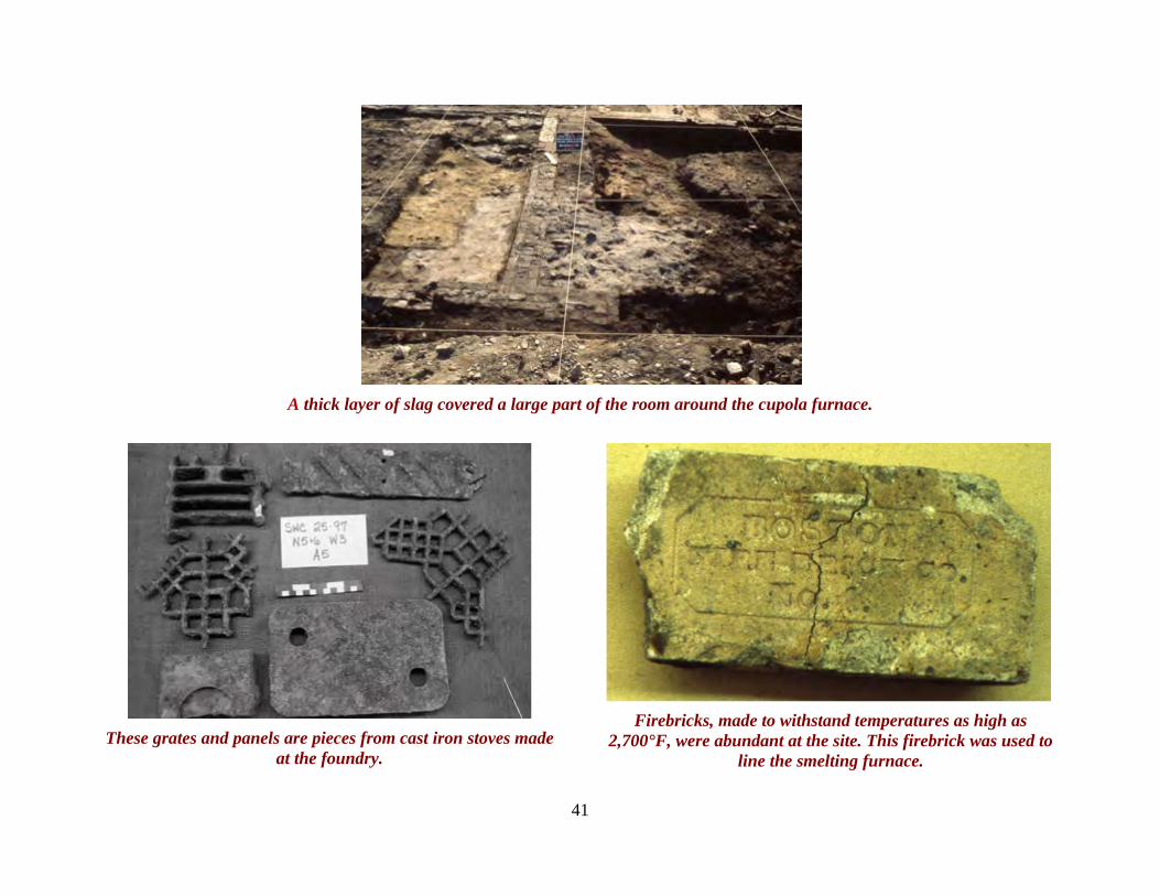
41
A thick layer of slag covered a large part of the room around the cupola furnace.
These grates and panels are pieces from cast iron stoves made
at the foundry.
Firebricks, made to withstand temperatures as high as
2,700°F, were abundant at the site. This firebrick was used to line the smelting furnace.
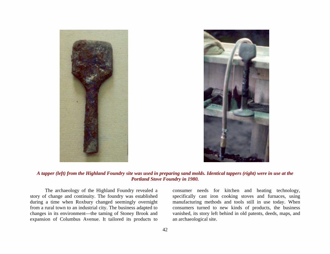
42
A tapper (left) from the Highland Foundry site was used in preparing sand molds. Identical tappers (right) were in use at the Portland Stove Foundry in 1980.
The archaeology of the Highland Foundry revealed a story of change and continuity. The foundry was established during a time when Roxbury changed seemingly overnight from a rural town to an industrial city. The business adapted to changes in its environment—the taming of Stoney Brook and expansion of Columbus Avenue. It tailored its products to
consumer needs for kitchen and heating technology, specifically cast iron cooking stoves and furnaces, using manufacturing methods and tools still in use today. When consumers turned to new kinds of products, the business vanished, its story left behind in old patents, deeds, maps, and an archaeological site.
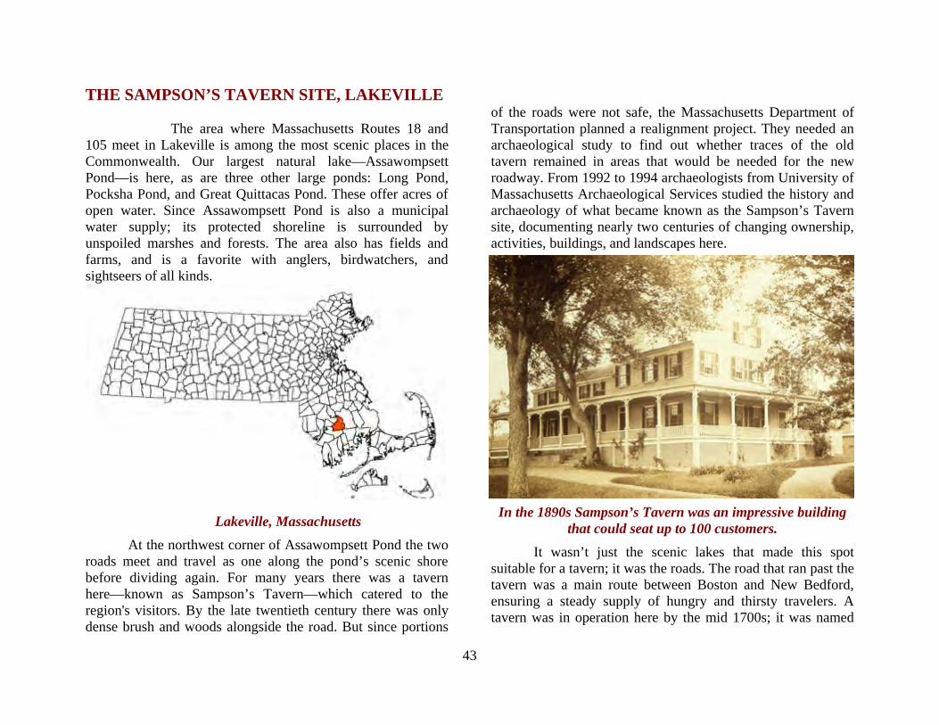
43
THE SAMPSON’S TAVERN SITE, LAKEVILLE
The area where Massachusetts Routes 18 and 105 meet in Lakeville is among the most scenic places in the Commonwealth. Our largest natural lake—Assawompsett Pond—is here, as are three other large ponds: Long Pond, Pocksha Pond, and Great Quittacas Pond. These offer acres of open water. Since Assawompsett Pond is also a municipal water supply; its protected shoreline is surrounded by unspoiled marshes and forests. The area also has fields and farms, and is a favorite with anglers, birdwatchers, and sightseers of all kinds.
Lakeville, Massachusetts At the northwest corner of Assawompsett Pond the two
roads meet and travel as one along the pond’s scenic shore before dividing again. For many years there was a tavern here—known as Sampson’s Tavern—which catered to the region's visitors. By the late twentieth century there was only dense brush and woods alongside the road. But since portions
of the roads were not safe, the Massachusetts Department of Transportation planned a realignment project. They needed an archaeological study to find out whether traces of the old tavern remained in areas that would be needed for the new roadway. From 1992 to 1994 archaeologists from University of Massachusetts Archaeological Services studied the history and archaeology of what became known as the Sampson’s Tavern site, documenting nearly two centuries of changing ownership, activities, buildings, and landscapes here.
In the 1890s Sampson’s Tavern was an impressive building that could seat up to 100 customers.
It wasn’t just the scenic lakes that made this spot suitable for a tavern; it was the roads. The road that ran past the tavern was a main route between Boston and New Bedford, ensuring a steady supply of hungry and thirsty travelers. A tavern was in operation here by the mid 1700s; it was named

44
Sampson’s Tavern when the Sampson family purchased the property in 1768. Over the decades, the tavern expanded in size and function. It became known as a resort, catering to sportsmen as well as travelers. It served the local community with a mail service and a store. It became a favorite dining spot for wealthy New Bedford whaling merchants. Important figures such as Daniel Webster and Henry David Thoreau are thought to have dined there. Eventually the property was bought by the wealthy Perry family of New Bedford who used it as a summer home. After a devastating fire swept through the
complex, the buildings were abandoned; in 1911 they were demolished. When the archaeologists arrived in 1992, more than 70 years of overgrowth had created a nearly impenetrable thicket. Trees had grown up throughout the site, and they in turn were covered with a dense mat of bittersweet vines, some of which were as thick as a man’s arm. The first task for the archaeologists was to clear the vegetation so they could identify and map the tavern’s visible ruins.
This plan shows the cleared areas, excavation units and identified buildings carefully mapped by the archaeologists.
The archaeologists begin to map and photograph visible ruins. Note the thick vegetation and brush.
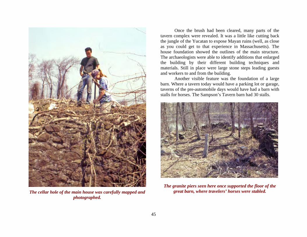
45
The cellar hole of the main house was carefully mapped and
photographed.
Once the brush had been cleared, many parts of the tavern complex were revealed. It was a little like cutting back the jungle of the Yucatan to expose Mayan ruins (well, as close as you could get to that experience in Massachusetts). The house foundation showed the outlines of the main structure. The archaeologists were able to identify additions that enlarged the building by their different building techniques and materials. Still in place were large stone steps leading guests and workers to and from the building. Another visible feature was the foundation of a large barn. Where a tavern today would have a parking lot or garage, taverns of the pre-automobile days would have had a barn with stalls for horses. The Sampson’s Tavern barn had 30 stalls.
The granite piers seen here once supported the floor of the great barn, where travelers’ horses were stabled.
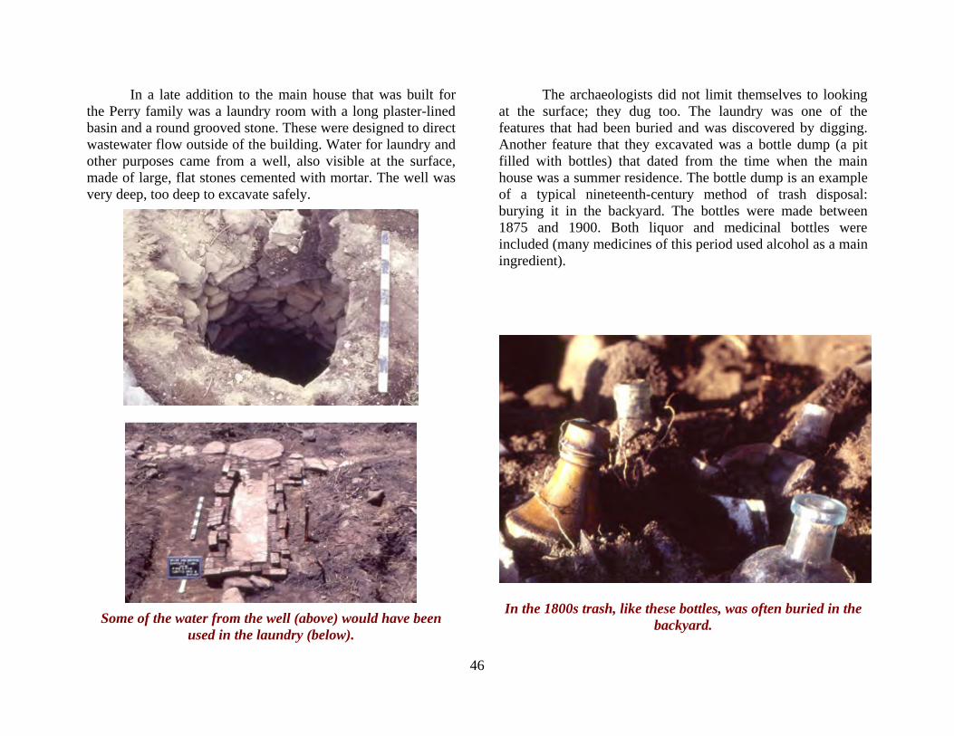
46
In a late addition to the main house that was built for the Perry family was a laundry room with a long plaster-lined basin and a round grooved stone. These were designed to direct wastewater flow outside of the building. Water for laundry and other purposes came from a well, also visible at the surface, made of large, flat stones cemented with mortar. The well was very deep, too deep to excavate safely.
Some of the water from the well (above) would have been
used in the laundry (below).
The archaeologists did not limit themselves to looking at the surface; they dug too. The laundry was one of the features that had been buried and was discovered by digging. Another feature that they excavated was a bottle dump (a pit filled with bottles) that dated from the time when the main house was a summer residence. The bottle dump is an example of a typical nineteenth-century method of trash disposal: burying it in the backyard. The bottles were made between 1875 and 1900. Both liquor and medicinal bottles were included (many medicines of this period used alcohol as a main ingredient).
In the 1800s trash, like these bottles, was often buried in the backyard.
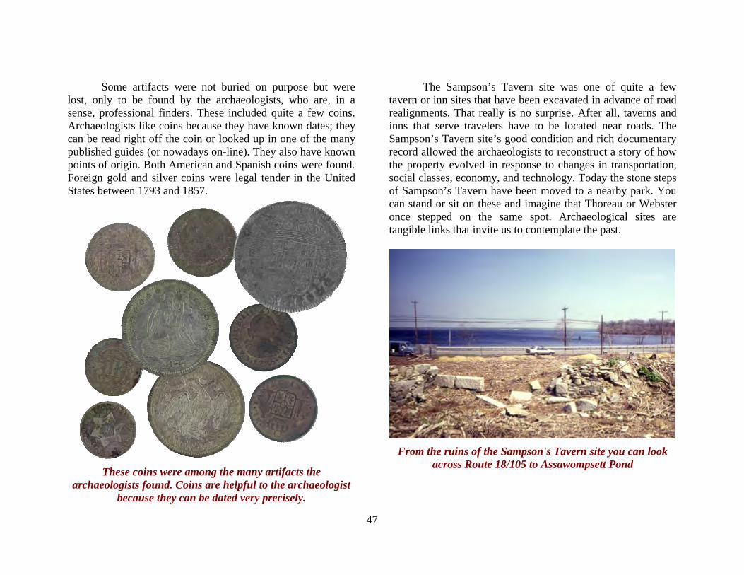
47
Some artifacts were not buried on purpose but were lost, only to be found by the archaeologists, who are, in a sense, professional finders. These included quite a few coins. Archaeologists like coins because they have known dates; they can be read right off the coin or looked up in one of the many published guides (or nowadays on-line). They also have known points of origin. Both American and Spanish coins were found. Foreign gold and silver coins were legal tender in the United States between 1793 and 1857.
These coins were among the many artifacts the
archaeologists found. Coins are helpful to the archaeologist because they can be dated very precisely.
The Sampson’s Tavern site was one of quite a few tavern or inn sites that have been excavated in advance of road realignments. That really is no surprise. After all, taverns and inns that serve travelers have to be located near roads. The Sampson’s Tavern site’s good condition and rich documentary record allowed the archaeologists to reconstruct a story of how the property evolved in response to changes in transportation, social classes, economy, and technology. Today the stone steps of Sampson’s Tavern have been moved to a nearby park. You can stand or sit on these and imagine that Thoreau or Webster once stepped on the same spot. Archaeological sites are tangible links that invite us to contemplate the past.
From the ruins of the Sampson's Tavern site you can look
across Route 18/105 to Assawompsett Pond
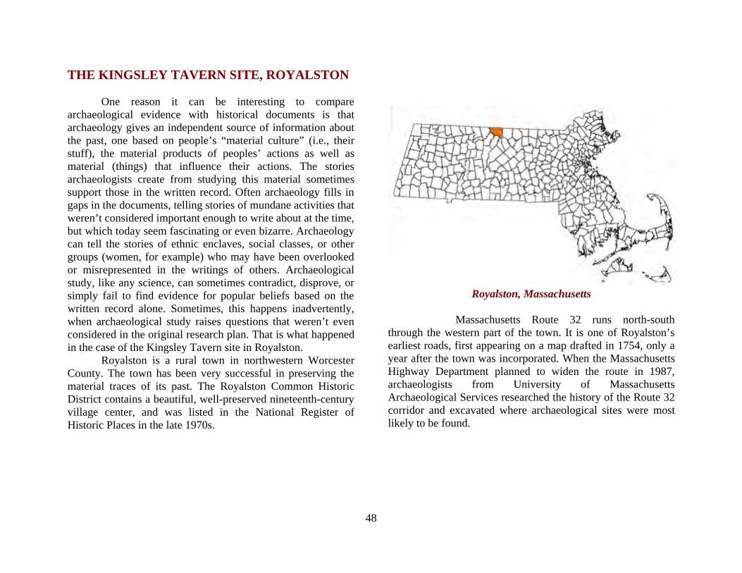
48
THE KINGSLEY TAVERN SITE, ROYALSTON One reason it can be interesting to compare archaeological evidence with historical documents is that archaeology gives an independent source of information about the past, one based on people’s “material culture” (i.e., their stuff), the material products of peoples’ actions as well as material (things) that influence their actions. The stories archaeologists create from studying this material sometimes support those in the written record. Often archaeology fills in gaps in the documents, telling stories of mundane activities that weren’t considered important enough to write about at the time, but which today seem fascinating or even bizarre. Archaeology can tell the stories of ethnic enclaves, social classes, or other groups (women, for example) who may have been overlooked or misrepresented in the writings of others. Archaeological study, like any science, can sometimes contradict, disprove, or simply fail to find evidence for popular beliefs based on the written record alone. Sometimes, this happens inadvertently, when archaeological study raises questions that weren’t even considered in the original research plan. That is what happened in the case of the Kingsley Tavern site in Royalston. Royalston is a rural town in northwestern Worcester County. The town has been very successful in preserving the material traces of its past. The Royalston Common Historic District contains a beautiful, well-preserved nineteenth-century village center, and was listed in the National Register of Historic Places in the late 1970s.
Royalston, Massachusetts
Massachusetts Route 32 runs north-south
through the western part of the town. It is one of Royalston’s earliest roads, first appearing on a map drafted in 1754, only a year after the town was incorporated. When the Massachusetts Highway Department planned to widen the route in 1987, archaeologists from University of Massachusetts Archaeological Services researched the history of the Route 32 corridor and excavated where archaeological sites were most likely to be found.

49
This map of Royalston from 1831 (five years after the Kingsley Tavern would have closed) shows the roads (highlighted in orange) that would eventually become
Massachusetts Route 32. The black arrows show where the archaeologists tested.
Route 32 has served as a local trade route linking places
to the south of Royalston—the small city of Athol, for example—with southwestern New Hampshire’s town of Richmond and city of Keene. It was a favorable location for commerce and business; along its length stood blacksmith shops, gristmills, sawmills, and, according to town history, a tavern. The Kingsley Tavern was first noted in a narrative by local historian Linda Caswell, published in the town in 1917. It was said to have been opened around 1800 by one Peleg Kingsley, and run under a succession of owners until it closed in 1826. That for the first quarter of the nineteenth century a tavern existed in a certain spot along what is now Route 32 had become an established fact among local residents. The archaeologists found plenty of evidence of nineteenth-century activity along Route 32. The nearly 2,000 artifacts and several stone foundations attested to occupation both domestic and commercial—a history of farmsteads, blacksmiths, and homes—but nothing was found to indicate a tavern. In particular, kitchen refuse and features such as privies and trash pits were notably lacking. There was simply no archaeological evidence for the kinds of things one would associate with a tavern, specifically, large-scale food and drink preparation and trash disposal. Moreover, further research in town records, deeds, and other documents found no mention at all of a tavern or restaurant here, apart from Caswell’s
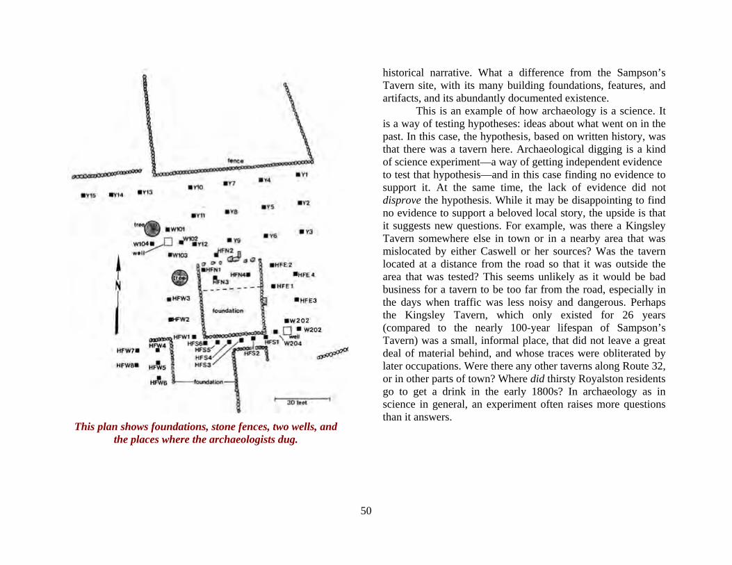
50
historical narrative. What a difference from the Sampson’s Tavern site, with its many building foundations, features, and artifacts, and its abundantly documented existence. This is an example of how archaeology is a science. It is a way of testing hypotheses: ideas about what went on in the past. In this case, the hypothesis, based on written history, was that there was a tavern here. Archaeological digging is a kind of science experiment—a way of getting independent evidence to test that hypothesis—and in this case finding no evidence to support it. At the same time, the lack of evidence did not disprove the hypothesis. While it may be disappointing to find no evidence to support a beloved local story, the upside is that it suggests new questions. For example, was there a Kingsley Tavern somewhere else in town or in a nearby area that was mislocated by either Caswell or her sources? Was the tavern located at a distance from the road so that it was outside the area that was tested? This seems unlikely as it would be bad business for a tavern to be too far from the road, especially in the days when traffic was less noisy and dangerous. Perhaps the Kingsley Tavern, which only existed for 26 years (compared to the nearly 100-year lifespan of Sampson’s Tavern) was a small, informal place, that did not leave a great deal of material behind, and whose traces were obliterated by later occupations. Were there any other taverns along Route 32, or in other parts of town? Where did thirsty Royalston residents go to get a drink in the early 1800s? In archaeology as in science in general, an experiment often raises more questions than it answers.
This plan shows foundations, stone fences, two wells, and the places where the archaeologists dug.
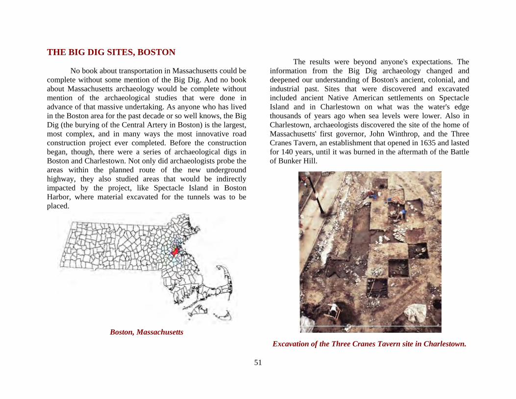
51
THE BIG DIG SITES, BOSTON No book about transportation in Massachusetts could be complete without some mention of the Big Dig. And no book about Massachusetts archaeology would be complete without mention of the archaeological studies that were done in advance of that massive undertaking. As anyone who has lived in the Boston area for the past decade or so well knows, the Big Dig (the burying of the Central Artery in Boston) is the largest, most complex, and in many ways the most innovative road construction project ever completed. Before the construction began, though, there were a series of archaeological digs in Boston and Charlestown. Not only did archaeologists probe the areas within the planned route of the new underground highway, they also studied areas that would be indirectly impacted by the project, like Spectacle Island in Boston Harbor, where material excavated for the tunnels was to be placed.
Boston, Massachusetts
The results were beyond anyone's expectations. The information from the Big Dig archaeology changed and deepened our understanding of Boston's ancient, colonial, and industrial past. Sites that were discovered and excavated included ancient Native American settlements on Spectacle Island and in Charlestown on what was the water's edge thousands of years ago when sea levels were lower. Also in Charlestown, archaeologists discovered the site of the home of Massachusetts' first governor, John Winthrop, and the Three Cranes Tavern, an establishment that opened in 1635 and lasted for 140 years, until it was burned in the aftermath of the Battle of Bunker Hill.
Excavation of the Three Cranes Tavern site in Charlestown.

52
This view of City Square Park in Charlestown shows a replica of the Three Cranes Tavern foundation in the
Foreground. Industrial sites were prominent among those uncovered in advance of the Big Dig. These included the American Glass Company, which operated in South Boston from 1847 to 1857, and small-scale workshops that made pottery, worked metals, tanned leather, and distilled spirits. Old maps and records related to these businesses allowed archaeologists to put names and histories to the artifacts they unearthed, which in turn gave new life and meaning to flesh out the bare bones of the documents. Old wharves told their tales of commerce and shipping, and privies yielded remarkably preserved artifacts of leather, wood, and even fine lace and silk. Among the extraordinary finds was what proved to be the oldest bowling ball in North America!
Upper left: an 18th-century stoneware jug from the Parker-Harris Pottery in Charlestown. Upper right: a fashionable gentleman's riding boot found at the Mill Pond Site near
Dock Square and the North End. Center: brass ornaments from the John Carnes' 18th-century workshop in the North
End. Bottom: scent bottles from the American Glass Company in South Boston

53
The oldest bowling ball in North America. This wooden (oak) ball dates between 1660 and 1716. It had a socket into which a metal weight would have been set, to make it trickier to roll. It was called a "lawn bowle" and was used in a game similar to bocce. The Puritan establishment of Boston disapproved of bowling and other pastimes that often involved betting, and even outlawed bowling for a time, but archaeology provides
hard evidence that such condemnation did not stop the people of Boston from having a little fun now and then.
One of the most poignant stories came from a humble privy (a pit toilet) in the North End. This was where the lawn bowle illustrated above was found. The privy was associated with the home of Katherine Nanny Naylor, who lived in the North End from 1630 to about 1715. Court records document her divorce from her abusive second husband, after which
Katherine continued to live here as a single parent. Artifacts found in her privy add fascinating details of her struggle to survive independently. Archaeologists found more than 250,000 seeds and pits from several types of fruit and over 158 fragments of silk, ribbon, and lace. These finds suggested that she may have cooked (possibly baking pies for sale) and sewed to make ends meet.
The Privy from the Katherine Nanny Naylor Site
Left: some of the many seeds and fruit pits preserved in the privy. Right: fragments of lace and silk from the privy.
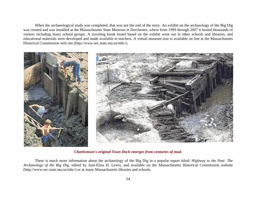
54
When the archaeological study was completed, that was not the end of the story. An exhibit on the archaeology of the Big Dig was created and was installed at the Massachusetts State Museum in Dorchester, where from 1999 through 2007 it hosted thousands of visitors including many school groups. A traveling kiosk board based on the exhibit went out to other schools and libraries, and educational materials were developed and made available to teachers. A virtual museum tour is available on line at the Massachusetts Historical Commission web site (http://www.sec.state.ma.us/mhc/).
Charlestown's original Town Dock emerges from centuries of mud. There is much more information about the archaeology of the Big Dig in a popular report titled: Highway to the Past: The Archaeology of the Big Dig, edited by Ann-Eliza H. Lewis, and available on the Massachusetts Historical Commission website (http://www.sec.state.ma.us/mhc/) or at many Massachusetts libraries and schools.
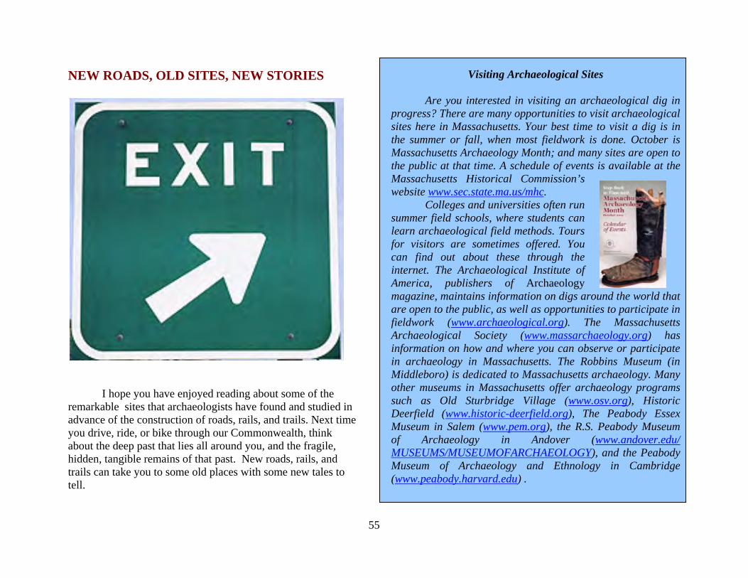
55
NEW ROADS, OLD SITES, NEW STORIES
I hope you have enjoyed reading about some of the remarkable sites that archaeologists have found and studied in advance of the construction of roads, rails, and trails. Next time you drive, ride, or bike through our Commonwealth, think about the deep past that lies all around you, and the fragile, hidden, tangible remains of that past. New roads, rails, and trails can take you to some old places with some new tales to tell.
Visiting Archaeological Sites
Are you interested in visiting an archaeological dig in progress? There are many opportunities to visit archaeological sites here in Massachusetts. Your best time to visit a dig is in the summer or fall, when most fieldwork is done. October is Massachusetts Archaeology Month; and many sites are open to the public at that time. A schedule of events is available at the Massachusetts Historical Commission’s website www.sec.state.ma.us/mhc. Colleges and universities often run summer field schools, where students can learn archaeological field methods. Tours for visitors are sometimes offered. You can find out about these through the internet. The Archaeological Institute of America, publishers of Archaeology magazine, maintains information on digs around the world that are open to the public, as well as opportunities to participate in fieldwork (www.archaeological.org). The Massachusetts Archaeological Society (www.massarchaeology.org) has information on how and where you can observe or participate in archaeology in Massachusetts. The Robbins Museum (in Middleboro) is dedicated to Massachusetts archaeology. Many other museums in Massachusetts offer archaeology programs such as Old Sturbridge Village (www.osv.org), Historic Deerfield (www.historic-deerfield.org), The Peabody Essex Museum in Salem (www.pem.org), the R.S. Peabody Museum of Archaeology in Andover (www.andover.edu/ MUSEUMS/MUSEUMOFARCHAEOLOGY), and the Peabody Museum of Archaeology and Ethnology in Cambridge (www.peabody.harvard.edu) .

56
If you would like to learn more about the archaeology of Massachusetts, there are several places to begin. A good introduction to the ancient Native American peoples of Massachusetts is the book titled: The First Peoples of the Northeast, written by Esther K. Braun and David P. Braun, published by Moccasin Hill Press in 1994. This is an excellent introduction to the archaeology of the region for the non-archaeologist. If you are interested in the archaeology of the industrial revolution, Living on the Boott tells the story of the archaeology of the mills of Lowell, Massachusetts, one of the early textile manufacturing centers in the United States. The book was written by Stephen A. Mrozowski, Mary C. Beaudry, and Grace H. Ziesing and is published by the University of Massachusetts Press.
If you would like to learn more about how archaeology is done, there are many excellent college-level textbooks on archaeological methods. One of the best, in my opinion, is Linking to the Past by Kenneth L. Feder, published by Oxford University Press in 2008. It is an engaging read and draws many examples from New England archaeology. The Massachusetts Archaeological Society offers a wide range of resources for those interested in archaeology from the casual amateur to the professional. The Society publishes a journal The Bulletin of the Massachusetts Archaeological Society, operates the Robbins Museum located in Middleborough, hosts conferences and presentations, and offers opportunities to participate in archaeological excavations. There are several local chapters around the state. You can find more information about the Society on line at www.massarchaeology.org.

57
ACKNOWLEDGEMENTS
This publication was made possible through Transportation Enhancement Program funding provided by the Federal Highway Administration (FHWA) and Massachusetts Department of Transportation (MassDOT) under an Interdepartmental Service Agreement administered by John Rempelakis, Archaeological Resources Supervisor at the MassDOT and Brona Simon, Massachusetts State Archaeologist and Executive Director of the Massachusetts Historical Commission, a division of the Massachusetts Secretary of State, William Francis Galvin, Secretary of the Commonwealth For this booklet, I would like to especially thank Brona Simon, who provided valuable insights, guidance, and encouragement. Ed Bell, Senior Archaeologist at the Massachusetts Historical Commission, made many useful suggestions after reading an early draft of this booklet. Ann-Eliza Lewis wrote an early draft and outline for this booklet, which I was delighted to use. John Rempelakis wrote an elegant study of Massachusetts transportation archaeology from which I borrowed many ideas and even turns of phrase for this booklet. John also provided many helpful comments on an early draft of this booklet. Jennifer Poulsen of the Massachusetts Historical Commission was incredibly helpful in locating artifacts, photographs, slides, and documents associated with many of the projects described in these pages. Thank you also to Mitchell Mulholland and Kathryn Curran of
University of Massachusetts Archaeological Services and Deborah Cox and Diana Doucette of The Public Archaeology Laboratory, Inc., who provided help with images and reports from several projects summarized in this booklet. Any errors, omissions, or other shortcomings are my own responsibility. Eric S. Johnson, Amherst, Massachusetts, May 2012 This Report was Supported by the Federal Highway Administration This document is disseminated under the sponsorship of the U.S. Department of Transportation in the interest of information exchange. The United States Government assumes no liability for its contents or use thereof. The contents of this report reflect the views of the author, who is responsible for the accuracy of the data presented herein. The contents do not necessarily reflect the official policy of the Department of Transportation. The report does not constitute a standard, specification, or regulation. The United States Government does not endorse products or manufacturers. Trade or manufacturers’ names appear herein only because they are considered essential to the object of this document.

58
Photograph and Illustration Credits All illustrations and photographs are by the author except as noted below: Page credit cover: background University of Massachusetts Archaeological Services (UMAS) cover: left insert Museum of Afro-American History 1 highway sign photograph by J. Stephen Conn 3 Institute for Conservation Archaeology (ICA) 5 Public Archaeology Laboratory, Inc. (PAL) 6 PAL 7 PAL 9 PAL 11 University of Massachusetts Archaeological Services (UMAS) 12 UMAS 14 PAL 15 PAL 16 PAL 17 PAL 19 UMAS 20 UMAS 21 atlatl weight: UMAS 22 left: UMAS right: UMAS and the author 24 PAL 25 PAL 30 PAL 31 PAL 32 talon bone: PAL bald eagle, Steve Maslowski/U.S. Fish and Wildlife Service (USFWS)
Page credit 33 maize kernel: PAL Atlantic sturgeon: USFWS grey seal at Nantucket NWR photograph by Amanda Boyd, USFWS 34 historicstockmarket.com 35 Museum of Afro American History 36 Museum of Afro American History 37 horseshoes: Museum of Afro American History 38 Museum of Afro American History 39 Museum of Afro American History 40 Museum of Afro American History 41 Museum of Afro American History 42 Museum of Afro American History 43 UMAS 44 UMAS 45 UMAS 46 UMAS 47 UMAS 49 UMAS 50 UMAS 51 Massachusetts Historical Commission (MHC) 52 MHC 53 MHC 54 MHC