Embed Size (px)
Citation preview
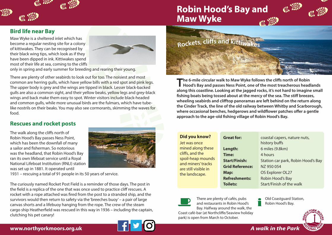
The 6-mile circular walk to Maw Wyke follows the cliffs north of Robin Hood’s Bay and passes Ness Point, one of the most treacherous headlands
along this coastline. Looking at the jagged rocks, it’s not hard to imagine small fishing boats being tossed about at the mercy of the sea. The stiff breezes, wheeling seabirds and clifftop panoramas are left behind on the return along the Cinder Track, the line of the old railway between Whitby and Scarborough, where occasional benches, hedgerows and wildflower patches offer a gentle approach to the age-old fishing village of Robin Hood’s Bay.
Bird life near BayMaw Wyke is a sheltered inlet which has become a regular nesting site for a colony of kittiwakes. They can be recognised by their black wing tips, which look as if they have been dipped in ink. Kittiwakes spend most of their life at sea, coming to the cliffs only in spring and early summer for breeding and rearing their young.
There are plenty of other seabirds to look out for too. The noisiest and most common are herring gulls, which have yellow bills with a red spot and pink legs. The upper body is grey and the wings are tipped in black. Lesser black-backed gulls are also a common sight, and their yellow beaks, yellow legs and grey-black wings and back make them easy to spot. Winter visitors include black-headed and common gulls, while more unusual birds are the fulmars, which have tube-like nostrils on their beaks. You may also see cormorants, skimming the waves for food.
Rescues and rocket postsThe walk along the cliffs north of Robin Hood’s Bay passes Ness Point, which has been the downfall of many a sailor and fisherman. So notorious was the headland, that Robin Hood’s Bay ran its own lifeboat service until a Royal National Lifeboat Institution (RNLI) station was set up in 1881. It operated until 1931 – rescuing a total of 91 people in its 50 years of service.
The curiously named Rocket Post Field is a reminder of those days. The post in the field is a replica of the one that was once used to practice cliff rescues. A rocket with a rope attached was fired from the post to a stranded ship, and the survivors would then return to safety via the ‘breeches buoy’ – a pair of large canvas shorts and a lifebuoy hanging from the rope. The crew of the steam cargo ship Heatherfield was rescued in this way in 1936 – including the captain, clutching his pet canary!
Robin Hood’s Bay and Maw Wyke
Rockets, cliff s and kittiwakes
Great for: coastal capers, nature nuts, history buffsLength: 6 miles (9.8km)Time: 4 hoursStart/Finish: Station car park, Robin Hood’s BayGrid Reference: NZ 950 054Map: OS Explorer OL27Refreshments: Robin Hood’s BayToilets: Start/Finish of the walk
A walk in the Park
Did you know?Jet was once mined along these cliffs, and the spoil-heap mounds and miners’ tracks are still visible in the landscape.
There are plenty of cafés, pubs and restaurants in Robin Hood’s Bay. Halfway around the walk, the
Coast café-bar (at Northcliffe/Seaview holiday park) is open from March to October.
www.northyorkmoors.org.uk
Old Coastguard Station, Robin Hood’s Bay.

Where the clifftop path is unfenced, it is advisable to keep your dog on a short lead for safety. It is also safer if you put your dog
on a lead on the old railway line path when cyclists or horse-riders pass.
. . . Rockets, cliff s and kittiwakes . . .
It’s fairly easy going for the most part, following the well-signposted Cleveland Way National Trail on the outward part, with no stiles and just
one steep climb up through the caravan park before Maw Wyke. The return is along the flat Cinder Track, which is shared with cyclists and horse-riders.
Route instructions Leave the car park (opposite the toilets) and go down to the main road. Cross over, go left, them immediately right along the residential road, Mount Pleasant North (signposted ‘Cinder Track, Cleveland Way’).
Go through the gate and follow the cliff path (signposted ‘Cleveland Way’), passing through Rocket Post Field.
Turn left before Maw Wyke and walk up through the caravan park.
Turn right and walk along the lane (signposted ‘Footpath, Hawsker’). Keep going past the main entrance to the holiday park, bearing left and right along the lane.
Turn left (at a National Route 1 cycle sign) and follow the old railway trackbed (caravans on your right), all the way to Robin Hood’s Bay.
At point 2 (by the gate) turn left, then right, to return to the car park.
1
2
3
4
5
© Crown copyright and database rights 2016You are not permitted to copy, sub-license, distribute
or sell any of this data to third parties in any form.Ordnance Survey 100021930
1 2
3
45
North York Moors National Park Authority, The Old Vicarage, Bondgate, Helmsley, York YO62 5BP
Robin Hood’s Bay, looking towards Ravenscar by Mark Denton


![Van Wyke - Imitating Bodies and Clothes[1][1]](https://img.pdfslide.net/doc/110x75/547acd31b479597c098b4b9a/van-wyke-imitating-bodies-and-clothes11.jpg)