Embed Size (px)
Citation preview

ROCKBANK PRECINCT STRUCTURE PLAN - August 2016 1
RockbankPrecinct Structure Plan
August 2016
OLD
LEA
KES
RD
PAYN
ES R
D
TRO
UPS
RD
NTH
WESTERN FREEWAY
GREIGS RD
WESTCOTT PDE
LEAK
ES R
D
LEAK
ES R
D
ROCK
BAN
K RD
TOOLERN RD
Melbourne-Ballarat rail corridor
RockbankTownship
DO
WN
ING
ST
TRO
UPS
RD
STH
FAU
LKN
ER R
D
MURRAY RD
IRAMOO CIRCUIT
STEWART CRES
LEO
NID
DR
potential rail stabling yard
Primary
Secondary
Primary
Primary
Primary
Primary
precinct boundaryresidential
medium density residentialcommercialmixed use rockbank major town centrelocal convenience centrepotential government schoolexisting government schoolpotential non-government schoolcommunity facilitiesurban plazaindoor recreationservice open spacecredited open spacelocal sports reserve - existingregional open spacerockbank railway stationrockbank railway station precinctcaravan parkpublic transport facilitiesouter metropolitan ring transport corridor (OMR)
freeway
landscape bu�er / redundant road reserveutilities - servicingexisting emergency servicesarterial road (six lanes)arterial road (four lanes)connector street - boulevardconnector street key local access streetexisting urban areafuture urban area
Rockbank Precinct Structure Plan
Copyright, Victorian Planning Authority, 2016 The state of Victoria does not warrant the accuracy or completeness of information in this publication and any person using or relying upon such information does so on the basis that the State of Victoria shall bear no responsibility or liability whatsoever for any errors, faults, defects or omission in the information.
1:25,000 @ A40 200 400 600 800 1,000m
Plan 3 - Future Urban Structure
NOTE : Refer to Plan 6 for open space details

Note: Any reference to the Victorian Planning Authority (VPA) in this document is a reference to the Growth Areas Authority (GAA) as defined under the Planning & Environment Act 1987.
2 ROCKBANK PRECINCT STRUCTURE PLAN - August 2016
CONTENTS
1.0 INTRODUCTION 51.1 How to read this document 71.2 Land to which the precinct structure plan applies 71.3 Background information 71.4 Rockbank Development Contributions Plan 7
2.0 OUTCOMES 92.1 Vision 92.2 Objectives 102.3 Land budget 11
3.0 IMPLEMENTATION 153.1 Image, character, heritage & housing 153.2 Town centres & employment 213.3 Community facilities & education 293.4 Open space 313.5 Biodiversity & threatened species 353.6 Transport & movement 373.7 Integrated water management & utilities 433.8 Infrastructure delivery & development staging 48
4.0 APPENDICES 56Appendix A Detailed land use budget (property specific) 56
Appendix B Street cross sections (standard) 62
Appendix C Street cross sections (non-standard variations) 76
Appendix D Rockbank Major Town Centre key design principles 84
Appendix E Local convenience centre key design principles 87
Appendix F Service placement guidelines 90
Appendix G Open space delivery guidelines 91
PLANSPlan 1 Regional Context 4Plan 2 Precinct Features 6Plan 3 Future Urban Structure 8Plan 4 Land Budget 12Plan 5 Image, Character, Housing, Community & Employment 14Plan 6 Open Space 30Plan 7 Native Vegetation Retention & Removal 34Plan 8 Road Network 36Plan 9 Public Transport & Path Network 40Plan 10 Integrated Water Management 42Plan 11 Utilities 46
TABLESTable 1 Summary land use budget 13
Table 2 Housing type by lot size guide 16
Table 3 Housing delivery guide 17
Table 4 Anticipated precinct employment creation guide 25
Table 5 Open space delivery guide 31
Table 6 Stormwater drainage & water quality treatment infrastructure delivery guide 45
Table 7 Precinct Infrastructure Plan 50
FIGURESFigure 1 Westcott Parade Precinct Urban Design Framework
Concept Plan 18Figure 2 Rockbank Major Town Centre Urban Design Framework
Concept Plan 20Figure 3 Rockbank Major Town Centre Organising Elements 22Figure 4 Rockbank Mixed Commercial Precinct Urban Design
Framework Concept Plan 26
ROCKBANK PRECINCT STRUCTURE PLAN - August 2016 3

SUNSHINE
EASTWERRIBEE
Western subregion boundaryMetropolitan regionMetropolitan urban boundaryUrban areaRoad networkRail networkLevel crossing removalTram networkRoad initiativeRail initiativeNew stationPotential ferry routeNational employment clusterTransport gateway – existingTransport gateway – futureMetropolitan intermodal system terminal(indicative location)State signi�cant industrial precinct – existingState signi�cant industrial precinct – futureBusiness and residential (as shown in growth corridor plans)Health/Education precinctHealth precinctEducation precinct Metropolitan activity centre – existingMetropolitan activity centre – futureActivity centre – existing and futureBoulevard to be investigated/implementedRegional open space – futureUrban renewal areaBiodiversity conservation areaMajor open spaceWaterwayAirport
MAP 31 – WESTERN SUBREGIONSOURCE: DEPARTMENT OF TRANSPORT, PLANNING AND LOCAL INFRASTRUCTURE, 2014
Note: This map is a diagrammatic of the structural elements of Plan Melbourne.
TOOLERN
BACCHUSMARSH
WERRIBEESOUTH
SUNBURY
MELBOURNEAIRPORT
MELBOURNECENTRAL BUSINESS
DISTRICT
WesternGrasslandReserve
WesternGrasslandReserve
Future WesternInterstate
FreightTerminal
Proposed Kororoit
Regional Park
ToolernRegional Park
Point CookCoastal Park
OuterMetropolitanRoad & Rail
AVALON AIRPORT
Port Phillip Bay(Western Shoreline)
Ramsar Site
Rockbank
Plumpton
Caroline Springs
St. Albans
Sunshinecorridor
Brimbank
Hop
kins
Rd. Deer Park
Rockbank North
Western Fwy
Princes Fwy
Port Phillip Bay
Maribyrnong River
MeltonHealth
© The State of Victoria. Department of Transport, Planning and Local Infrastructure, 2014. The State of Victoria does not warrant the accuracy or completeness in this publication and any person using or relying upon such information does so on the basis that the State of Victoria shall bear no responsibility or liability whatsoever for any errors, faults defects or omissions in the information.
0 5 10
Kilometres
DiggersRest
Rockbank
20Km
15Km
10Km
5Km
precinct boundary
western subregion boundary
urban growth boundary (UGB)
urban area
road network
rail network
tram network
outer metropolitan ring transport corridor
national employment cluster
transport gateway – future
state significant industrial precinct – existing
state significant industrial precinct – future
business and residential
health / education precinct
health precinct
education precinct
principal town centre – existing
principal town centre – future
town centre – existing and future
regional open space – future
regional open space - existing
urban renewal area
biodiversity conservation area
waterway
airport
NOTE : Map : Western Subregion, Plan Melbourne
Plan 1 - Regional ContextRockbank Precinct Structure Plan
Copyright, Victorian Planning Authority, 2016 The state of Victoria does not warrant the accuracy or completeness of information in this publication and any person using or relying upon such information does so on the basis that the State of Victoria shall bear no responsibility or liability whatsoever for any errors, faults, defects or omission in the information.
1:150,000 @ A4
0 2km 4km 6km 8km 10km
4 ROCKBANK PRECINCT STRUCTURE PLAN - August 2016

1.0 INTRODUCTIONRockbank Precinct Structure Plan (the PSP) has been prepared by the Victorian Planning Authority (VPA) in consultation with Melton City Council and with the assistance of Government agencies, service authorities and major stakeholders.
The PSP is a long-term plan for urban development. It describes how the land is expected to be developed, and how and where services are planned to support development.
The PSP guides proposed development within the Rockbank precinct.
Generally, the PSP:
• Sets out plans to guide the delivery of quality urban environments in accordance with relevant Victorian Government guidelines listed in this section
• Enables the transition of non-urban to urban land
• Sets the vision for how land should be developed and the outcomes achieved
• Outlines the projects required to ensure that future residents, visitors and workers within the area can be provided with timely access to services and transport necessary to support a quality, affordable lifestyle
• Sets out objectives, guidelines and requirements for land use and development
• Provides Government agencies, the Council, developers, investors and local communities with certainty about future development
• Addresses the requirements of the Environment Protection and Biodiversity Conservation Act 1999 (EPBC Act 1999) in accordance with an endorsed program under Part 10.
The PSP is informed by:
• The State and Local Planning Policy Framework set out in the Melton Planning Scheme
• Precinct Structure Planning Guidelines (Growth Areas Authority, 2008)
• Growth Corridor Plans: Managing Melbourne’s Growth Areas (GAA, 2012)
• Biodiversity Conservation Strategy for Melbourne’s Growth Corridors (the BCS) and applicable sub-regional species strategies (Department of Environment and Primary Industries, 2013)*
• Plan Melbourne (Victorian Government, 2014).
*On 5 September 2013, an approval under the EPBC Act 1999 was issued by the Commonwealth Minister for Environment, Heritage and Water. The approval applies to all actions associated with urban development in growth corridors in the expanded Melbourne 2010 Urban Growth Boundary as described on page 4 of the BCS. The approval has effect until 31 December 2060 and is subject to conditions specified in Annexure 1 of the approval. Provided the conditions of the EPBC Act approval are satisfied, individual assessment and approval under the EPBC Act is not required.
The following planning documents have been prepared in parallel with the PSP to inform and direct the future planning and development of the precinct:
• Rockbank Precinct Background Report, as described in section 1.3 of the PSP
• Rockbank Development Contributions Plan, as described in section 1.4 of the PSP.
ROCKBANK PRECINCT STRUCTURE PLAN - August 2016 5

PAYN
ES R
D
MO
UN
T CO
TTRE
LL R
D
TRO
UPS
RD
NTH
GREIGS RD
WESTCOTT PDE
OLD
LEA
KES
RD
LEA
KES
RD
LEA
KES
RD
STEWART CRES
DO
WN
ING
ST
TRO
UPS
RD
STH
FAU
LKN
ER R
D
MURRAY RD
IRAMOO CIRCUIT
LEO
NID
DR
Ian CowieRecreation Reserve
Caravan park
Rockbank Hall &Rockbank Kindergarten
Rockbank General Store &existing businesses
Rockbank RailwayStation
Pitson House & existing businesses
Rockbank CFA Station
RockbankPrimary School
Paynes Cottage
Serbian OrthodoxChurch
Missen House
Melbourne-Ballarat rail corridor
ROCKBANKTOWNSHIP
WESTERN FREEWAY
OU
TER
MET
ROPO
LITA
N R
ING
TRA
NSP
ORT
CO
RRID
OR
(OM
R)
precinct boundary
existing urban area (rockbank township)
future urban area
contours (0.5m intervals)
government school
community facilities
local sports reserve
caravan park
commercial
waterbodies - historical
scattered trees
area of Aboriginal cultural heritage sensitivity
area of Aboriginal cultural heritage likelihood
european heritage site
dry stone wall
existing building
existing road
rail line & railway station
Rockbank Precinct Structure Plan
Copyright, Victorian Planning Authority, 2016 The state of Victoria does not warrant the accuracy or completeness of information in this publication and any person using or relying upon such information does so on the basis that the State of Victoria shall bear no responsibility or liability whatsoever for any errors, faults, defects or omission in the information.
1:25,000 @ A4
0 200 400 600 800 1,000m
Plan 2 - Precinct Features
6 ROCKBANK PRECINCT STRUCTURE PLAN - August 2016

1.1 How to read this document
The PSP guides land use and development where a planning permit is required under the Urban Growth Zone or another zone where that zone references this precinct structure plan.
A planning application and planning permit must implement the outcomes of the PSP. The outcomes are expressed as the vision and objectives of the PSP.
Each element of the PSP contains requirements and guidelines as relevant.
Requirements must be adhered to in developing the land. Where they are not demonstrated in a permit application, requirements will usually be included as a condition on a planning permit whether or not they take the same wording as in this precinct structure plan. A requirement may reference a plan, table or figure in the PSP.
Guidelines express how discretion will be exercised by the responsible authority in certain matters that require a planning permit. If the responsible authority is satisfied that an application for an alternative to a guideline implements the outcomes the responsible authority may consider the alternative. A guideline may reference a plan, table or figure in the PSP.
Conditions that must be included in a planning permit are outlined in Schedule 7 to Clause 37.7 Urban Growth Zone (UGZ7) in the Melton Planning Scheme.
Meeting these requirements, guidelines and conditions will implement the outcomes of the PSP.
Development must also comply with other Acts and approvals, where relevant (e.g. the EPBC Act 1999 in the case of biodiversity or the Aboriginal Heritage Act 2006 in the case of cultural heritage, amongst others).
Not every aspect of the land’s use and development is addressed in the PSP and a responsible authority may manage development and issue permits as relevant under its general discretion.
1.2 Land to which the precinct structure plan applies
The PSP applies to approximately 752 hectares of land located 29 kilometres to the west of the Melbourne CBD. The precinct is bounded by the Western Freeway and the existing Rockbank Township to the north, Paynes Road to the west, Greigs Road to the south and the future Outer Metropolitan Ring (OMR) transport corridor to the east, beyond Troups Road North. The precinct is illustrated on Plan 1 of the PSP and on Melton Planning Scheme maps as UGZ7.
1.3 Background information
Rockbank Precinct Background Report provides detailed background information relating to the precinct, including its local and metropolitan context, history, landform and topography, biodiversity, drainage, open space, transport infrastructure and community facilities. The report also summarises various background technical studies that have informed the preparation of the PSP.
1.4 Rockbank Development Contributions Plan
Rockbank Development Contributions Plan (the DCP) sets out the requirements for development proponents to make contributions toward infrastructure required to support the development of the precinct. The DCP is a separate document incorporated into the Melton Planning Scheme and implemented through Schedule 7 to Clause 45.06 Development Contributions Plan Overlay (DCPO7) in the Melton Planning Scheme. The DCP applies to the same land area as the PSP.
ROCKBANK PRECINCT STRUCTURE PLAN - August 2016 7

OLD
LEA
KES
RD
PAYN
ES R
D
TRO
UPS
RD
NTH
WESTERN FREEWAY
GREIGS RD
WESTCOTT PDE
LEA
KES
RD
LEA
KES
RD
ROCK
BAN
K RD
TOOLERN RD
Melbourne-Ballarat rail corridor
RockbankTownship
DO
WN
ING
ST
TRO
UPS
RD
STH
FAU
LKN
ER R
D
MURRAY RD
IRAMOO CIRCUIT
STEWART CRES
LEO
NID
DR
potential rail stabling yard
Primary
Secondary
Primary
Primary
Primary
Primary
precinct boundary
residential
medium density residential
commercial
mixed use
rockbank major town centre
local convenience centre
potential government school
existing government school
potential non-government school
community facilities
urban plaza
indoor recreation
service open space
credited open space
local sports reserve - existing
regional open space
rockbank railway station
rockbank railway station precinct
caravan park
public transport facilities
outer metropolitan ring transport corridor (OMR)
freeway
landscape bu�er / redundant road reserve
utilities - servicing
existing emergency services
arterial road (six lanes)
arterial road (four lanes)
connector street - boulevard
connector street
key local access street
existing urban area
future urban area
Rockbank Precinct Structure Plan
Copyright, Victorian Planning Authority, 2016 The state of Victoria does not warrant the accuracy or completeness of information in this publication and any person using or relying upon such information does so on the basis that the State of Victoria shall bear no responsibility or liability whatsoever for any errors, faults, defects or omission in the information.
1:25,000 @ A4
0 200 400 600 800 1,000m
Plan 3 - Future Urban Structure
NOTE : Refer to Plan 6 for open space details
8 ROCKBANK PRECINCT STRUCTURE PLAN - August 2016

2.0 OUTCOMES
2.1 Vision
The Rockbank community will share in a vibrant precinct, distinguished by a transit-orientated town centre and a network of neighbourhood gathering places linked by waterways and local parks.
Rockbank Precinct Structure Plan outlines the growth of a historic agricultural settlement situated amongst basalt plains to a dynamic suburb that enhances its natural systems, preserves local heritage and fully integrates with the existing Rockbank Township.
Rockbank will be supported by an accessible open space network incorporating linear waterway corridors and generous, tree-lined nature strips. Local parks and sporting reserves will be directly linked by waterways with shared paths to maximise community access and amenity, and provide future opportunities for year-round irrigation across the park network.
A strong focus on cycling and pedestrian movement is continued throughout the precinct; a grassland reserve features prominently along Greigs Road, and all connector streets incorporate off-road shared paths that will combine seamlessly with the open space path network.
Social infrastructure will be centralised within each residential neighbourhood, mixing schools and community centres with sports reserves and the open space network. The hubs will provide a walkable destination for residents to build and strengthen bonds with friends, family and neighbours in their community. Rockbank will incorporate a secondary school, four new primary schools and three community centres of varied size and function.
Rockbank Major Town Centre and Rockbank Railway Station provide the key community focal point for the precinct and wider community. The town centre will offer extensive retail and commercial opportunities set within a tree-lined ‘high street’ setting, including civic buildings, leisure facilities and urban parks. A pedestrian plaza will directly address the upgraded Rockbank Railway Station as part of a modernised, electrified ‘Melton Line’ within the existing rail corridor.
Grid-pattern streets will provide efficient access across local neighbourhoods and to the arterial road network. The new Rockbank Road forms the central north-south spine of the precinct and provides direct access to the town centre and the Western Freeway. Existing at-grade points of access to the freeway are removed and an upgraded Leakes Road interchange provides the key intersection with the freeway. Leakes Road level crossing will close upon construction of the Rockbank Road Bridge, promoting commuter safety and prioritising pedestrian movements within the town centre. Bus services will link residents to all community and commercial destinations, particularly the town centre and railway station with its extensive park’n’ride facility and bus interchange.
Rockbank will offer diverse housing choices to support the full range of households and lifestyles. Medium and higher density housing will be delivered within and surrounding the town centre in close proximity to the railway station. Medium density housing will be encouraged in proximity to the open space network, along public transport routes and within walking distance of the town centre. Traditional homes will be developed throughout the precinct, all with access to community facilities and a variety of transport modes.
Rockbank Precinct Structure Plan establishes a growth framework for the suburb that affords residents the freedom to live and travel as they desire as it promotes community health and social interaction. The plan aims to support future economic and environmental resilience, and fairly apportions services, mobility and cost across the precinct.
ROCKBANK PRECINCT STRUCTURE PLAN - August 2016 9

2.2 Objectives
The development of the Rockbank PSP area is guided by a set of key objectives.
OBJECTIVES
IMAGE, CHARACTER, HERITAGE & HOUSING
O1 Create an urban environment that establishes attractive, interesting and walkable links to key destinations.
O2
Grow an attractive urban environment through the cultivation of a complex and expansive open space network built around natural and constructed wetlands, waterways, parks and public spaces and a street network highlighted by large canopy tree cover.
O3 Encourage a strong sense of place accented by local cultural landmarks through the protection of dry stone walls and heritage buildings and enhancement of wetlands and their surroundings.
O4 Establish landmark built form or public realm at gateway sites to key destinations such as Rockbank Major Town Centre, partnered with landscape treatments that establish user interest and encourage community engagement.
O5
Deliver a wide variety of housing types and densities that ensures critical mass of residents within walking distance of the town centre, key community infrastructure and public transport (at a minimum average residential density of 16.5 dwellings per net developable hectare).
O6 Ensure that the precinct is well integrated with the existing Rockbank Township.
TOWN CENTRES & EMPLOYMENT
O7 Build a transit-orientated town centre that highlights its connection with Rockbank Railway Station via a central pedestrian plaza fronted by retail and civic services to create a high quality gathering place and focal point.
O8 Design interesting public realm supported by strong view lines and landscaping in Rockbank Major Town Centre that will compel visitors of all ages to move and pause between destinations, with pedestrians and cyclists prioritised.
O9 Create a vibrant town centre through the combination of civic, entertainment and community uses with core retail and commercial functions that will provide for a range of local employment opportunities.
O10 Allow flexibility for an evolving town centre that adapts to surrounding population growth and transport network expansion and utilises a mix of built form and scale that can facilitate resilience against economic structural change.
COMMUNITY FACILITIES, EDUCATION & OPEN SPACE
O11 Develop a walkable network of community hubs that provide access to social, education, recreation and health services within each neighbourhood.
O12 Maximise the use and enjoyment of open space by diversifying park design and scale to deliver a range of user experiences.
O13 Provide for government and non-government school sites to meet a strategically justified need for State and Catholic education in the area.
O14 Deliver community facilities throughout the precinct that support residents of all ages, encourage social interaction and engagement, support positive health outcomes and create a sense of place and civic pride.
O15 Ensure that the health and wellbeing of residents is protected by delivering a built environment of facilities and amenities that promote healthy lifestyle practices, social interaction, civic engagement and access to services.
10 ROCKBANK PRECINCT STRUCTURE PLAN - August 2016
BUSHFIRE MANAGEMENT
O16 Ensure that bushfire hazards are identified and that protection measures are considered in the layout and design of the local street network, subdivisions and buildings and works.
TRANSPORT & MOVEMENT
O17 Enhance access to Rockbank Major Town Centre via an upgraded Rockbank Railway Station, grade separation of key road and pedestrian links, and positive development interface to the rail corridor.
O18 Create a comprehensive pedestrian and cycling network that ensures residents can be active and travel safely and directly throughout the precinct within the road and open space networks.
O19 Promote public transport movements by providing a bus-capable road network that services key destinations throughout the precinct and links directly to Rockbank Railway Station.
O20 Provide a high-amenity, slow-speed and permeable road network that prioritises community access and safety whilst providing straightforward connections to the wider network.
INTEGRATED WATER MANAGEMENT & UTILITIES
O21
Deliver an integrated water management system that reduces reliance on reticulated potable water, increases the re-use of alternative water, minimises flood risk, ensures waterway health, and contributes towards a sustainable and green urban environment.
INFRASTRUCTURE DELIVERY & DEVELOPMENT STAGING
O22 Encourage development staging to be co-ordinated with the delivery of key local and state infrastructure.
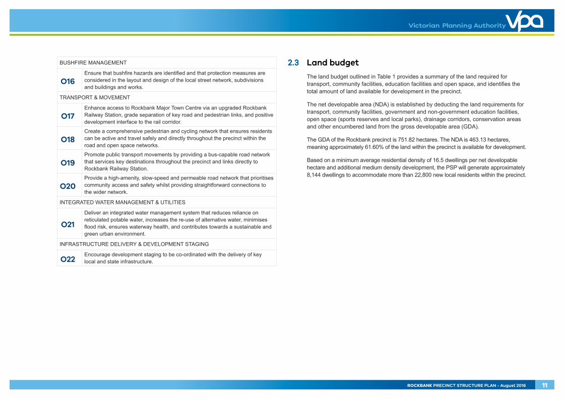
2.3 Land budget
The land budget outlined in Table 1 provides a summary of the land required for transport, community facilities, education facilities and open space, and identifies the total amount of land available for development in the precinct.
The net developable area (NDA) is established by deducting the land requirements for transport, community facilities, government and non-government education facilities, open space (sports reserves and local parks), drainage corridors, conservation areas and other encumbered land from the gross developable area (GDA).
The GDA of the Rockbank precinct is 751.82 hectares. The NDA is 463.13 hectares, meaning approximately 61.60% of the land within the precinct is available for development.
Based on a minimum average residential density of 16.5 dwellings per net developable hectare and additional medium density development, the PSP will generate approximately 8,144 dwellings to accommodate more than 22,800 new local residents within the precinct.
ROCKBANK PRECINCT STRUCTURE PLAN - August 2016 11

OLD
LEA
KES
RD
PAYN
ES R
D
TRO
UPS
RD
NTH
WESTERN FREEWAY
GREIGS RD
WESTCOTT PDE
STEWART CRES
LEA
KES
RD
LEA
KES
RD
DO
WN
ING
ST
TRO
UPS
RD
STH
FAU
LKN
ER R
D
MURRAY RD
ROCK
BAN
K RD
TOOLERN RDIRAMOO CIRCUIT
Melbourne-Ballarat rail corridor
RockbankTownship
LEO
NID
DR
42
43
3
12
4
5
7
8
6
10
11
9
12
13
14
17-E18-E19-E
20-E21-E22-E
23-E24 25 26272930313233
34
28
36 3738
39
404445 46
4748
4950
51
5253 54
55
57
56 58
59 60
61
62
63
64
67
R2-
R3-
R4-
R5-
66
65
68
69
7172
73
7475 76
77
7879
80
81 82
83
84
85
86
87
88
89
90
92
93
94
95
96
9897
99101
102
103
104 105 106
107
109
108
110
35
41
15-E
16-E
70
R1-
113
R6-
91
112
111
100
112
4
precinct boundary
arterial road - existing road reserve
arterial road - existing road reserve (potential commercial development)
public acquisition overlay (PAO)
arterial road - widening & intersection �aring (DCP land)
non - arterial road - existing road reserve
public transport facilities / reserve
existing government school
potential government school
potential non-government school
local community facilities (DCP land)
local indoor recreation (DCP land)
existing �re service facility
conservation area
waterway & drainage reserve
landscape bu�er / redundant road reserve
local sports reserve (DCP land)
local sports reserve - existing
urban plaza (DCP land)
local park
municipal regional sports reserve (council acquisition)
utilities - servicing facilities
rockbank major town centre boundary
net developable area - employment
net developable area - residential
property boundary & number
Rockbank Precinct Structure Plan
Copyright, Victorian Planning Authority, 2016 The state of Victoria does not warrant the accuracy or completeness of information in this publication and any person using or relying upon such information does so on the basis that the State of Victoria shall bear no responsibility or liability whatsoever for any errors, faults, defects or omission in the information.
1:25,000 @ A4
0 200 400 600 800 1,000m
Plan 4 - Land Use Budget
12 ROCKBANK PRECINCT STRUCTURE PLAN - August 2016
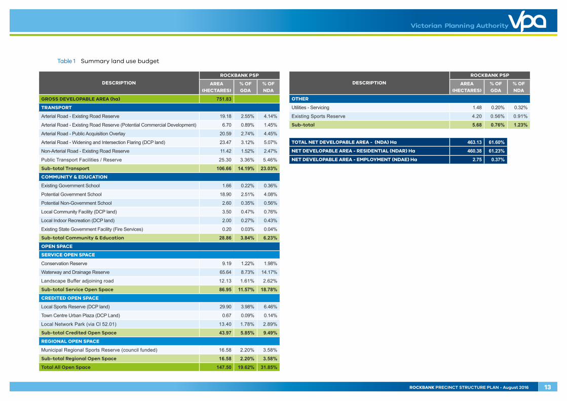
Table 1 Summary land use budget
DESCRIPTION
ROCKBANK PSP
AREA (HECTARES)
% OF GDA
% OF NDA
GROSS DEVELOPABLE AREA (ha) 751.83TRANSPORT
Arterial Road - Existing Road Reserve 19.18 2.55% 4.14%
Arterial Road - Existing Road Reserve (Potential Commercial Development) 6.70 0.89% 1.45%
Arterial Road - Public Acquisition Overlay 20.59 2.74% 4.45%
Arterial Road - Widening and Intersection Flaring (DCP land) 23.47 3.12% 5.07%
Non-Arterial Road - Existing Road Reserve 11.42 1.52% 2.47%
Public Transport Facilities / Reserve 25.30 3.36% 5.46%
Sub-total Transport 106.66 14.19% 23.03%COMMUNITY & EDUCATION
Existing Government School 1.66 0.22% 0.36%
Potential Government School 18.90 2.51% 4.08%
Potential Non-Government School 2.60 0.35% 0.56%
Local Community Facility (DCP land) 3.50 0.47% 0.76%
Local Indoor Recreation (DCP land) 2.00 0.27% 0.43%
Existing State Government Facility (Fire Services) 0.20 0.03% 0.04%
Sub-total Community & Education 28.86 3.84% 6.23%OPEN SPACE
SERVICE OPEN SPACE
Conservation Reserve 9.19 1.22% 1.98%
Waterway and Drainage Reserve 65.64 8.73% 14.17%
Landscape Buffer adjoining road 12.13 1.61% 2.62%
Sub-total Service Open Space 86.95 11.57% 18.78%CREDITED OPEN SPACE
Local Sports Reserve (DCP land) 29.90 3.98% 6.46%
Town Centre Urban Plaza (DCP Land) 0.67 0.09% 0.14%
Local Network Park (via Cl 52.01) 13.40 1.78% 2.89%
Sub-total Credited Open Space 43.97 5.85% 9.49%REGIONAL OPEN SPACE
Municipal Regional Sports Reserve (council funded) 16.58 2.20% 3.58%
Sub-total Regional Open Space 16.58 2.20% 3.58%
Total All Open Space 147.50 19.62% 31.85%
DESCRIPTION
ROCKBANK PSP
AREA (HECTARES)
% OF GDA
% OF NDA
OTHER
Utilities - Servicing 1.48 0.20% 0.32%
Existing Sports Reserve 4.20 0.56% 0.91%
Sub-total 5.68 0.76% 1.23%
TOTAL NET DEVELOPABLE AREA - (NDA) Ha 463.13 61.60%
NET DEVELOPABLE AREA - RESIDENTIAL (NDAR) Ha 460.38 61.23%
NET DEVELOPABLE AREA - EMPLOYMENT (NDAE) Ha 2.75 0.37%
ROCKBANK PRECINCT STRUCTURE PLAN - August 2016 13

OLD
LEA
KES
RD
PAYN
ES R
D
TRO
UPS
RD
NTH
WESTERN FREEWAY
GREIGS RD
WESTCOTT PDE
LEA
KES
RD
LEA
KES
RD
ROCK
BAN
K RD
TOOLERN RD
Melbourne-Ballarat rail corridor
RockbankTownship
DO
WN
ING
ST
TRO
UPS
RD
STH
FAU
LKN
ER R
D
MURRAY RD
IRAMOO CIRCUIT
STEWART CRES
LEO
NID
DR
precinct boundary
rockbank major town centre
rockbank mixed commercial precinct
rockbank township community hub
rockbank north community hub
rockbank south community hub
rockbank east community hub
rockbank west community hub
medium density residential
residential
local convenience centre
community hub walkable catchment (400 metres)
major town centre catchment (one kilometre)
viewlines
Rockbank Precinct Structure Plan
Copyright, Victorian Planning Authority, 2016 The state of Victoria does not warrant the accuracy or completeness of information in this publication and any person using or relying upon such information does so on the basis that the State of Victoria shall bear no responsibility or liability whatsoever for any errors, faults, defects or omission in the information.
1:25,000 @ A4
0 200 400 600 800 1,000m
Plan 5 - Image, Character, Housing, Community & Employment
14 ROCKBANK PRECINCT STRUCTURE PLAN - August 2016

3.0 IMPLEMENTATION
3.1 Image, character, heritage & housing
3.1.1 Image & character
IMAGE & CHARACTER REQUIREMENTS
R1 All public landscape areas must be planted and designed to the satisfaction of the responsible authority.
R2
Street trees must be planted on both sides of all roads and streets (excluding laneways) at regular intervals appropriate to tree size at maturity in accordance with relevant Council landscaping policy unless otherwise agreed by the responsible authority.
R3 Street tree planting on declared arterial roads must be established in accordance with VicRoads Tree Planting Policy to the satisfaction of the coordinating road authority.
R4 Boundary fences forward of the building line must not exceed 1.2 metres in height.
IMAGE & CHARACTER GUIDELINES
G1 Street networks within subdivisions should be designed to maximise the number of connections and direct views to the open space network and the closest community hub.
G2 A consistent suite of lighting and furniture should be used across neighbourhoods, appropriate to the type and role of street or public space, unless otherwise agreed by the responsible authority.
G3 Built form on corner lots should provide a positive address to both frontages through the use of architectural treatments.
G4 Built form should add to the precinct’s character by providing an attractive street address that encourages passive surveillance and visual interest.
G5 Planting of indigenous trees is encouraged along streets fronting the open space network.
G6 Salvaged rocks should be incorporated in the design and construction of waterways and open spaces, where possible.
G7 Sites in prominent locations, such as Rockbank Major Town Centre and major intersections, should be developed to greater height and density with reduced setbacks creating valued destinations (refer to Appendix D).
G8 High quality and cohesive landscape treatments should be provided throughout the precinct, most particularly in streetscapes and along waterway corridors.
3.1.2 Heritage
HERITAGE REQUIREMENTS
R5 Development of land adjoining a heritage site identified under the Heritage Overlay must be respectful of the scale, form, siting and heritage significance of the place or building.
R6
Dry stone walls illustrated on Plan 2 must be retained unless otherwise agreed by the responsible authority. Dry stone walls to be retained must:
• Be situated within a public open space or road reserve to the satisfaction of the responsible authority
• Have a suitable landscape interface• Be checked by a suitably qualified dry stone waller for any loose stones that
are to be reinstated in the wall in secure positions• Retain post-and-wire or post-and-rail fences situated within the walls, with
any wire protruding beyond the vertical face of the wall reinstated to its original position or removed
• Be incorporated into subdivision design to minimise disturbance to the walls (e.g. utilisation of existing openings for vehicle and pedestrian access).
R7 Reinstatement or repair of walls must be undertaken by a suitably qualified dry stone waller and is to be consistent with the construction style of the original wall.
R8
Installation of services across the alignment of retained dry stone walls must be undertaken by boring rather than open trenching. If open trenching or disturbance to the wall is unavoidable, a minimum section of wall may be temporarily removed and then reinstated to original condition under the supervision of a suitably qualified dry stone waller to the satisfaction of the responsible authority.
R9
Reinstatement of walls must use stone from (in order of priority):
• The original wall in that location (including fallen stone adjacent to the wall)• A nearby section of wall approved to be removed• Any adjacent paddock containing wall parts that can be recovered.
HERITAGE GUIDELINES
G9 Where a planning permit has been granted and an existing dry stone wall is to be removed, landowners should consult with Council to determine whether the material can be retained for use elsewhere.
ROCKBANK PRECINCT STRUCTURE PLAN - August 2016 15

3.1.3 Housing
HOUSING REQUIREMENTS
R10 Residential subdivisions must deliver a broad range of lot sizes capable of accommodating a variety of housing types to cater to a range of lot prices and promote affordability.
R11
Subdivision of land must deliver an overall minimum average density of 16.5 dwellings per net developable hectare. Where a subdivision proposal represents a single stage or limited number of stages, development proponents should demonstrate how the subdivision will contribute to the eventual satisfaction of this requirement through further stages of development.
R12 Housing identified as ‘medium density residential’ on Plan 5 must be delivered at a medium density or higher, as illustrated on Plan 5 and outlined in Table 3.
R13
Dwellings must front or side:
• Waterways and the open space network (including local parks)• Arterial roads and connector streets• Melbourne-Ballarat rail corridor, unless otherwise agreed by the responsible
authority.
The siding of lots to waterways, open space and primary street frontages must be kept to a minimum.
R14
Subdivision applications must include indicative layouts for any lots identified for future development of medium and higher density or integrated housing that suitably demonstrate:
• Potential dwelling yield• Active interfaces with adjacent streets, open space and waterways• Safe and effective internal vehicle and pedestrian circulation• Delivery of diverse lot sizes and housing types• Servicing arrangements.
R15 Where housing is proposed adjacent to an acoustic wall, dwellings must front an internal road that runs directly parallel to the acoustic wall unless otherwise agreed by the responsible authority.
HOUSING GUIDELINES
G10
Subdivision of land within a 400-metre walkable distance of community hubs illustrated on Plan 5 and designated public transport routes illustrated on Plan 9 should create a range of lot sizes suitable for the delivery of medium density housing outlined in Table 2.
G11 Specialised housing forms such as lifestyle communities, retirement living or aged care facilities should be located in close proximity to town centres and community hubs and accessible by public transport.
Table 2 Housing type by lot size guide
The following table provides an example of the typical housing types that might be built on a range of lot sizes that support the housing diversity objectives.
HOUSING TYPES THAT MAY BE SUPPORTED
LOT SIZE CATEGORY (M2)
LESS THAN 300M2
301-600M2MORE THAN 600M
Small lot housing (including town houses and attached, semi-detached and detached houses)
Dual occupancies, including duplex
Detached housing
Multi-unit housing sites (including terraces, row houses and villas)
Stacked housing (including apartments and walk-up flats)
16 ROCKBANK PRECINCT STRUCTURE PLAN - August 2016

Table 3 Housing delivery guide
The following table provides guidance on the required lot yield within areas identified for medium density residential development on Plan 5 to meet housing density objectives and underpin the viability of Rockbank Major Town Centre and local convenience centres. It is anticipated that medium and higher density residential development in these areas will create at least 548 additional dwellings above the conventional density requirement for a minimum average of 16.5 dwellings per net developable hectare. Additionally, land identified as Rockbank Major Town Centre will ultimately require a minimum average residential density of 30 dwellings per net developable hectare, with the quantum of housing to be determined by a future urban design framework.
AREAS IDENTIFIED FOR MEDIUM DENSITY
RESIDENTIAL DEVELOPMENT
APPROXIMATE MEDIUM DENSITY
RESIDENTIAL AREA (TOTAL)
AVERAGE MINIMUM DWELLINGS PER
NET DEVELOPABLE HECTARE
LOT YIELD FOR IDENTIFIED
MEDIUM DENSITY RESIDENTIAL AREA
Rockbank Major Town Centre
Determined by urban design framework
30 Determined by urban design framework
Land surrounding Rockbank Major Town Centre
44 hectares 24 1056 dwellings
Land surrounding local convenience centre (Rockbank East Community Hub)
14 hectares 24 336 dwellings
Land surrounding local convenience centre (Rockbank South Community Hub)
15 hectares 24 360 dwellings
ROCKBANK PRECINCT STRUCTURE PLAN - August 2016 17
OLD
LEA
KES
RD
PAYN
ES R
D
TRO
UPS
RD
NTH
WESTERN FREEWAY
GREIGS RD
WESTCOTT PDE
LEA
KES
RD
LEA
KES
RD
ROCK
BAN
K RD
TOOLERN RD
Melbourne-Ballarat rail corridor
RockbankTownship
DO
WN
ING
ST
TRO
UPS
RD
STH
FAU
LKN
ER R
D
MURRAY RD
IRAMOO CIRCUIT
STEWART CRES
LEO
NID
DR
potential rail stabling yard
Primary
Secondary
Primary
Primary
Primary
Primary
precinct boundary
residential
medium density residential
commercial
mixed use
rockbank major town centre
local convenience centre
potential government school
existing government school
potential non-government school
community facilities
urban plaza
indoor recreation
service open space
credited open space
local sports reserve - existing
regional open space
rockbank railway station
rockbank railway station precinct
caravan park
public transport facilities
outer metropolitan ring transport corridor (OMR)
freeway
landscape bu�er / redundant road reserve
utilities - servicing
existing emergency services
arterial road (six lanes)
arterial road (four lanes)
connector street - boulevard
connector street
key local access street
existing urban area
future urban area
Rockbank Precinct Structure Plan
Copyright, Victorian Planning Authority, 2016 The state of Victoria does not warrant the accuracy or completeness of information in this publication and any person using or relying upon such information does so on the basis that the State of Victoria shall bear no responsibility or liability whatsoever for any errors, faults, defects or omission in the information.
1:25,000 @ A4
0 200 400 600 800 1,000m
Plan 3 - Future Urban Structure
NOTE : Refer to Plan 6 for open space details
Westcott Parade
RockbankTownship
RockbankMajor Town Centre
RockbankRailway Station
To Rockbank Road& Western Freeway
Rockbank Hall &Rockbank Kindergarten
Ian CowieRecreationReserve
RockbankPrimarySchool
Caravan Park
CFA
area subject to urban design framework
community facility (existing)
caravan park (existing)
residential
local park / sports reserve
school (existing)
retarding basin
local street
landscaping
freeway interface
roundabout
pedestrian rail / freeway crossing
NOTE : Potential need for noise attenuation of sensitive uses for land abutting the freeway
Rockbank Precinct Structure Plan
Copyright, Victorian Planning Authority, 2016 The state of Victoria does not warrant the accuracy or completeness of information in this publication and any person using or relying upon such information does so on the basis that the State of Victoria shall bear no responsibility or liability whatsoever for any errors, faults, defects or omission in the information.
Figure 1 - Westcott Parade Precinct Urban Design Framework Concept Plan 1:6,000 @ A4
0 75 150 225 300m
18 ROCKBANK PRECINCT STRUCTURE PLAN - August 2016

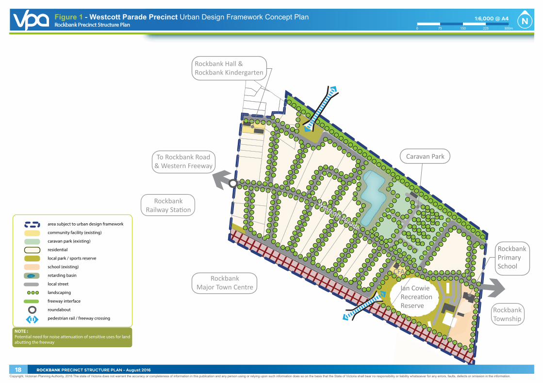
3.1.4 Westcott Parade Precinct
Westcott Parade Precinct applies to an area of land adjoining the western edge of Rockbank Township that forms part of the function of the township and is subject to urban renewal and development as part of the PSP.
The precinct is generally characterised as a low density residential area containing small-acreage properties that directly access the east-west road, Westcott Parade. The precinct features several existing public facilities, including Rockbank Hall, Rockbank Primary School, Rockbank Kindergarten and Ian Cowie Recreation Reserve (home of the Rockbank Football Club), and includes a small number of existing local businesses and conventional dwellings and a caravan park.
The precinct will support extensive redevelopment given its direct proximity to Rockbank Railway Station and Rockbank Major Town Centre, including opportunities for medium and higher density residential housing along Westcott Parade. Westcott Parade road reserve will be urbanised to cater for pedestrian and cycling movements, and direct access to the road from each existing property will allow subdivision and redevelopment to occur without reliance on adjoining land. Importantly, existing businesses and community facilities can continue to operate as part of the urbanised precinct.
An urban design framework (UDF) will be prepared to guide the development of Westcott Parade Precinct. The UDF will expand on the urban design principles illustrated in Figure 1 of the PSP.
WESTCOTT PARADE PRECINCT REQUIREMENTS
R16
A UDF must be approved by the responsible authority for Westcott Parade Precinct within the ‘area subject to urban design framework’ area as illustrated in Figure 1.The UDF must address the following as a minimum:
• Relevant design guidelines prepared by the Victorian Government and Melton City Council
• A response to the Westcott Parade Precinct Urban Design Framework Concept Plan (Figure 1)
• A land use plan that identifies a hierarchy of public spaces including local parks, pedestrian connections and cycling links, urban spaces and landscape nodes
• Design of the interface with the Western Freeway (including noise attenuation), Melbourne-Ballarat rail corridor, Rockbank Township community hub, caravan park, existing commercial uses, surrounding residential uses (including Old Leakes Road and the existing township) and local parks
• A fine-grain road network, including the urban upgrade of Westcott Parade and direct access
• Opportunities for medium and higher density housing and its design• Staging and indicative development timing, including interim drainage
infrastructure requirements • Guidelines to positively address environmental sustainability including
integrated water management and energy conservation.
ROCKBANK PRECINCT STRUCTURE PLAN - August 2016 19

OLD
LEA
KES
RD
PAYN
ES R
D
TRO
UPS
RD
NTH
WESTERN FREEWAY
GREIGS RD
WESTCOTT PDELE
AKE
S RD
LEA
KES
RD
ROCK
BAN
K RD
TOOLERN RD
Melbourne-Ballarat rail corridor
RockbankTownship
DO
WN
ING
ST
TRO
UPS
RD
STH
FAU
LKN
ER R
D
MURRAY RD
IRAMOO CIRCUIT
STEWART CRES
LEO
NID
DR
potential rail stabling yard
Primary
Secondary
Primary
Primary
Primary
Primary
precinct boundary
residential
medium density residential
commercial
mixed use
rockbank major town centre
local convenience centre
potential government school
existing government school
potential non-government school
community facilities
urban plaza
indoor recreation
service open space
credited open space
local sports reserve - existing
regional open space
rockbank railway station
rockbank railway station precinct
caravan park
public transport facilities
outer metropolitan ring transport corridor (OMR)
freeway
landscape bu�er / redundant road reserve
utilities - servicing
existing emergency services
arterial road (six lanes)
arterial road (four lanes)
connector street - boulevard
connector street
key local access street
existing urban area
future urban area
Rockbank Precinct Structure Plan
Copyright, Victorian Planning Authority, 2016 The state of Victoria does not warrant the accuracy or completeness of information in this publication and any person using or relying upon such information does so on the basis that the State of Victoria shall bear no responsibility or liability whatsoever for any errors, faults, defects or omission in the information.
1:25,000 @ A4
0 200 400 600 800 1,000m
Plan 3 - Future Urban Structure
NOTE : Refer to Plan 6 for open space details
area subject to urban design framework
community facility
anchor retail
speciality retail
mixed use
large format retail
station
medical
commercial (above ground)
medium & higher density residential
key active frontage
at-grade car park
public square (pedestrian hardscape)
local park
garden softscape
landscaping
local street
roundabout
signalised intersection
left in / left out intersection
raised pedestrian crossing
potential bus priority link
pedestrian rail crossing
Rockbank Railway Station
Rockbank RoadBridge
Church
Ian CowieRecreationReserve
Rockbank Park
Westcott Parade
Old
Lea
kes
Road
Rock
bank
Roa
d
Rockbank Precinct Structure Plan
Copyright, Victorian Planning Authority, 2016 The state of Victoria does not warrant the accuracy or completeness of information in this publication and any person using or relying upon such information does so on the basis that the State of Victoria shall bear no responsibility or liability whatsoever for any errors, faults, defects or omission in the information.
Figure 2 - Rockbank Major Town Centre Urban Design Framework Concept Plan 1:4,000 @ A4
0 50 100 150 200m
20 ROCKBANK PRECINCT STRUCTURE PLAN - August 2016

3.2 Town centres & employment
3.2.1 Rockbank Major Town Centre
Rockbank Major Town Centre is located at Rockbank Railway Station and centred on Leakes Road. Rockbank Major Town Centre is part of a network of town centres within the City of Melton that will support the Toolern Principal Town Centre. It will also be supported by local town centres and local convenience centres in the surrounding area.
The town centre will be a vibrant mixed use centre with the retail core supported by a range of commercial, civic, educational, community, entertainment and recreational uses that generate business investment and provide residents with local employment opportunities and easy access to a range of services. A network of urban parks, plazas and town squares will promote social interaction amongst high quality public realm. Importantly, medium and higher density residential development within and surrounding the town centre will generate a critical mass of residents and street activation during the day, at night and on the weekends.
The town centre will be connected to the surrounding residential neighbourhoods and wider area by a range of transport modes including rail, bus and a comprehensive network of pedestrian and cycling routes. The Rockbank Railway Station precinct will include a bus interchange and is located in the core of the town centre, connecting directly to the pedestrian-focused high street via a station plaza in the heart of the centre. The public and active transport network is supported by a road network that includes the Western Freeway, Rockbank Road and Greigs Road, allowing direct access to the wider community.
The town centre will support both physical and economic growth as it evolves. Early delivery of essential services within this centre balanced with a deliberate land bank to allow for long-term, higher order uses is fundamental to creating an authentic, sustainable and liveable town centre for the Rockbank and surrounding communities.
An urban design framework will be prepared to guide the development of Rockbank Major Town Centre. The UDF will expand on the urban design principles illustrated in Figure 2 and outlined in Appendix D of the PSP.
ROCKBANK PRECINCT STRUCTURE PLAN - August 2016 21

KEY VIEWPASSIVE
OPEN SPACE
KEY VIEWTOWN SQUARE
KEY VIEWSTATION
ELEVATEDVIEW FROMOVERPASS
ELEVATEDVIEW FROMOVERPASS
ELEVATEDVIEW FROM
STATION
KEY VIEW LINES
POTENTIAL VIEWSTO OPEN SPACE
AREA SUBJECT TOURBAN DESIGN FRAMEWORK
PRIMARYOPEN SPACE NODE
SECONDARYOPEN SPACE NODE
LINEAR GREEN LINK
AREA SUBJECT TOURBAN DESIGN FRAMEWORK
PRIMARYDESTINATION NODE
SECONDARYDESTINATION NODE
KEY CONNECTIONS
PLAZA
TOWN SQUARE
PLAZA
RAILWAYSTATION
CHURCH
MIXED USE
CIVIC
CIVICRETAIL/OFFICE
OFFICE
CONNECTOR STREETS
ACCESS STREETS
HIGH STREET TREATMENT
SIGNALISED INTERSECTION
ROUNDABOUT
RAIL FLYOVER
ARTERIAL ROAD
AREA SUBJECT TOURBAN DESIGN FRAMEWORK
• Develop a hierarchy of public open space that allows for a range of activities throughout the town centre from small passive urban spaces to large plazas which can accommodate a range of community events
• Integrate local parks into the hierarchy to provide an alternative to the urban landscaped spaces
• Design the public realm to reflect and respect the environmental and cultural heritage of the area including its location in the Western Volcanic Plains and proximity to Mount Cottrell
• Create strong pedestrian and cycle links both within the town centre and to the surrounding residential areas that incorporate landscape elements to create green and shaded streetscapes that encourage people to walk and cycle to the centre
• Ensure scale, massing and design of built form in the town centre reflects its long term role as a key destination in a metropolitan growth area.
• Create view lines that terminate on public open space or significant built form
• Capture immediate and long distance views to Mount Cottrell and other landscape features
• Ensure that the scale and mass of the built form is appropriate to the width of the street or public space to create comfortable spaces and streetscapes that have a sense of enclosure.
• Establish a road network that provides good access to the town centre without compromising the quality of the pedestrian-focused streets and spaces
• Design a bus interchange at Rockbank Railway Station that is accessible but keeps buses out of the plaza
• Divert heavy vehicles from high street.
Figure 3 Rockbank Major Town Centre organising elements
Figure 3a Open space & placemaking Figure 3b Views & vistas Figure 3c Road network
22 ROCKBANK PRECINCT STRUCTURE PLAN - August 2016

ON STREET PEDESTRIANNETWORK & CYCLE NETWORK
SHARED PEDESTRIAN ANDCYCLE PATH
PEDESTRIAN MOVEMENTCORRIDOR
PEDESTRIAN ZONE
POTENTIAL PEDESTRIANBRIDGE
AREA SUBJECT TOURBAN DESIGN FRAMEWORK
AREA SUBJECT TOURBAN DESIGN FRAMEWORK& TOWN CENTRE CHARACTER
RETAIL HIGH STREETCHARACTER
COMMERCIALCHARACTER
STATIONCHARACTER
MIXED USECHARACTER
CIVICCHARACTER
POTENTIAL MEDIUM& HIGHER DENSITY
RESIDENTIALCHARACTER
POTENTIAL MEDIUM& HIGHER DENSITY
RESIDENTIALCHARACTER
POTENTIAL MEDIUM& HIGHER DENSITY
RESIDENTIALCHARACTER
POTENTIAL MEDIUM& HIGHER DENSITY
RESIDENTIALCHARACTER
• Establish a hierarchy of pedestrian and cycle routes that provide good accessibility and strong connections between key destinations and spaces to create a walkable town centre
• Provide pedestrian and cycle connections along the railway interface that deviate into the town centre through the plaza and high street
• Ensure key streets within the core of the town centre have paths of a sufficient width allowing uses such as cafes to utilize the streetscape without compromising pedestrian and cycle movements
• Connect the north and south sides of the rail corridor via pedestrian thoroughfares at Rockbank Railway Station.
• Create a diverse and vibrant town centre that accommodates a variety of uses
• Recognise the different focus of each character precinct through the built form response whilst creating a strong town centre identity across all the precincts
• Ensure that the interfaces between character areas are sensitively designed to create a coherent built form outcome that contributes to local identity and creates a sense of place.
Stage 1: Early development of town centre to utilise existing Leakes Road to move north-south through an upgraded level crossing at the rail corridor
Stage 2: Rockbank Road to be constructed ‘at grade’ to the south as town centre continues to development
Stage 3: Rockbank Road rail flyover and western freeway interchange realignment constructed and Leakes Road level crossing closed, creating a pedestrian-friendly town centre.
Figure 3d Pedestrian & cyclist movement Figure 3e Character precincts
Figure 3f Staging
ROCKBANK PRECINCT STRUCTURE PLAN - August 2016 23

THIS PAGE HAS BEEN LEFT INTENTIONALLY BLANK
24 ROCKBANK PRECINCT STRUCTURE PLAN - August 2016

MAJOR TOWN CENTRE REQUIREMENTS
R17
A UDF must be approved by the responsible authority for Rockbank Major Town Centre within the ‘area subject to urban design framework’ as illustrated in Figure 2. The UDF must address the following:
• Relevant design guidelines prepared by the Victorian Government and Melton City Council
• A response to the Rockbank Major Town Centre Urban Design Framework Concept Plan (Figure 2) and the vision and organising elements set out in Figure 3, including the role and function of the town centre and how it integrates with the surrounding area
• A land use plan that identifies the appropriate location for all supported land uses and considers the relationship between these uses, including the integration of community facilities and services
• A response to Appendix D, referencing key design principles• A response to Table 4, referencing retail, office and commercial floor space• Bus priority lanes and signals where appropriate to access the Rockbank
Railway Station• A land use plan that identifies a hierarchy of public spaces including local
parks, pedestrian and cycle links, urban spaces and landscape nodes• Place making elements, character precincts and nodal destinations
within the town centre including a hierarchy of public spaces that provide opportunities for social interaction and local events
• Key views to the surrounding area and open space and the creation of vistas through the town centre to create interest in the streetscape and provide opportunities for fine-grained urban design outcomes
• Design of the interface with the Melbourne-Ballarat rail corridor, Rockbank Road and surrounding residential uses and local parks
• A fine-grain road network that identifies direct connectivity within, to and from the town centre
• Incorporation of public transport services, including Rockbank Railway Station and bus interchange, into the design of the town centre
• Opportunities for higher density housing within and surrounding the town centre and its design
• Staging and indicative development timing of the town centre• Guidelines to positively address environmental sustainability including
integrated water management and energy conservation• Provisions for car parking including the location and design of the car
parking areas and car parking rates for proposed uses within the town centre• Provision of service areas for deliveries and waste disposal including
access for larger vehicles and measures to minimise the impact on the amenity of the town centre and adjoining neighbourhood.
Table 4 Anticipated precinct employment creation guide
LAND USEEMPLOYMENT
MEASURE
JOBS PER EMPLOYMENT
MEASURE
ANTICIPATED QUANTITY OF
LAND USE
ANTICIPATED QUANTITY OF
JOBS
Secondary school (government) Jobs per site 90 1 90
Primary school (government) Jobs per site 40 4 160
Primary school (potential non-government)
Jobs per site 40 1 40
Kindergarten (Council) Jobs per site 15 4 60
Child care centre (private)
Jobs per 100 places 15 2 30
Medical centre Jobs per practitioner 9 1 9
Retail Jobs per 30m2 floor space 1 30,000 1,000
Office and/or commercial
Jobs per 20m2 floor space 1 7,500 375
Home-based business
Jobs per dwelling 0.05 8,144 408
TOTAL 2,172
ROCKBANK PRECINCT STRUCTURE PLAN - August 2016 25

OLD
LEA
KES
RD
PAYN
ES R
D
TRO
UPS
RD
NTH
WESTERN FREEWAY
GREIGS RD
WESTCOTT PDE
LEA
KES
RD
LEA
KES
RD
ROCK
BAN
K RD
TOOLERN RD
Melbourne-Ballarat rail corridor
RockbankTownship
DO
WN
ING
ST
TRO
UPS
RD
STH
FAU
LKN
ER R
D
MURRAY RD
IRAMOO CIRCUIT
STEWART CRES
LEO
NID
DR
potential rail stabling yard
Primary
Secondary
Primary
Primary
Primary
Primary
precinct boundary
residential
medium density residential
commercial
mixed use
rockbank major town centre
local convenience centre
potential government school
existing government school
potential non-government school
community facilities
urban plaza
indoor recreation
service open space
credited open space
local sports reserve - existing
regional open space
rockbank railway station
rockbank railway station precinct
caravan park
public transport facilities
outer metropolitan ring transport corridor (OMR)
freeway
landscape bu�er / redundant road reserve
utilities - servicing
existing emergency services
arterial road (six lanes)
arterial road (four lanes)
connector street - boulevard
connector street
key local access street
existing urban area
future urban area
Rockbank Precinct Structure Plan
Copyright, Victorian Planning Authority, 2016 The state of Victoria does not warrant the accuracy or completeness of information in this publication and any person using or relying upon such information does so on the basis that the State of Victoria shall bear no responsibility or liability whatsoever for any errors, faults, defects or omission in the information.
1:25,000 @ A4
0 200 400 600 800 1,000m
Plan 3 - Future Urban Structure
NOTE : Refer to Plan 6 for open space details
Ian CowieRecreation
Reserve
RockbankMajor Town Centre
RockbankRailway Station
Rockbank RoadBridge
Old
Lea
kes R
oad
Western Freeway Interchange
Rock
bank
Roa
d
area subject to urban design framework
mixed use (proposed)
commercial (existing)
commercial (proposed)
garden softscape
arterial road
local street
landscaping
roundabout
signalised intersection
pedestrian rail / freeway crossing
Rockbank Precinct Structure Plan
Copyright, Victorian Planning Authority, 2016 The state of Victoria does not warrant the accuracy or completeness of information in this publication and any person using or relying upon such information does so on the basis that the State of Victoria shall bear no responsibility or liability whatsoever for any errors, faults, defects or omission in the information.
Figure 4 - Mixed Use Precinct Urban Design Framework Concept Plan 1:6,000 @ A4
0 75 150 225 300m
26 ROCKBANK PRECINCT STRUCTURE PLAN - August 2016

3.2.2 Rockbank Mixed Commercial Precinct
Rockbank Mixed Commercial Precinct applies to an area of land to the north of Rockbank Major Town Centre and positioned on the opposing side of Rockbank Railway Station. The precinct is generally bounded by Old Leakes Road to the east, Rockbank Road to the west, the Western Freeway to the north and the Melbourne-Ballarat rail corridor to the south.
A mixed use neighbourhood will be established in the southern portion of the precinct, between Rockbank Railway Station and the extension of Westcott Parade, to deliver retail and commercial activity integrated with medium and high density residential housing. The neighbourhood will encourage built form that provides active uses at ground level and active street frontages on upper levels, particularly along key movement corridors and addressing the railway station.
An assortment of commercial land uses will be established further north, between the extension of Westcott Parade and the Western Freeway corridor. The area will support the development of offices, appropriate manufacturing and light industrial uses, and limited retail uses that do not adversely impact nearby residential neighbourhood in Westcott Parade Precinct. The character of this area will offer an appropriate buffer to the Leakes Road freeway interchange and complement the adjacent existing businesses.
The mixed commercial precinct will consolidate the role of Rockbank Major Town Centre as a significant, transit-orientated activity centre within the growth corridor.
An urban design framework will be prepared to guide the development of Rockbank Mixed Commercial Precinct. The UDF will expand on the urban design principles illustrated in Figure 4 and outlined in Appendix D of the PSP.
MIXED COMMERCIAL REQUIREMENTS
R18
A UDF must be approved by the responsible authority for Rockbank Mixed Commercial Precinct within the ‘area subject to urban design framework’ area as illustrated in Figure 4. The UDF must address the following as a minimum:
• Relevant design guidelines prepared by the Victorian Government and Melton City Council
• A response to the Rockbank Mixed Commercial Precinct Urban Design Framework Concept Plan (Figure 4) and the relevant vision and organising elements set out in Figure 3
• A land use plan that identifies the appropriate location for all supported land uses and considers the relationship between these uses, including the integration of community facilities and services
• A response to Appendix D, referencing relevant key design principles• A response to Table 4, referencing retail, office and commercial floor space
R18 cont
• Bus priority lanes and signals where appropriate to access the Rockbank Railway Station
• A land use plan that identifies a hierarchy of public spaces including pedestrian and cycle links, urban spaces and landscape nodes
• Place making elements and nodal destinations within the mixed use neighbourhood including a hierarchy of public spaces that provide opportunities for social interaction
• Key views to the surrounding open space and the creation of vistas through the mixed use neighbourhood to create interest in the streetscape
• Design of the interface with the Western Freeway including noise attenuation, Melbourne-Ballarat rail corridor, existing commercial uses, and surrounding residential areas (including Old Leakes Road and Westcott Parade Precinct)
• A fine-grain road network that identifies direct connectivity within, to and from Rockbank Railway Station and the connection and extension of Westcott Parade
• Construction of the upgrade to the Leakes Road interchange at the Western Freeway, including realignment of the interchange to accommodate Rockbank Road Bridge and associated transport infrastructure, and reconstruction of the Western Freeway ramps to maximise additional commercial land use opportunities
• Incorporation of public transport services, including Rockbank Railway Station and bus interchange, into the design of the mixed use neighbourhood
• Opportunities for medium and higher density housing within and surrounding the mixed use neighbourhood and its design
• Staging and indicative development timing of the precinct• Guidelines to positively address environmental sustainability including
integrated water management and energy conservation• Provisions for car parking including the location and design of the car
parking areas and car parking rates for proposed uses within the mixed use neighbourhood
• Provision of service areas for deliveries and waste disposal including access for larger vehicles and measures to minimise the impact on the amenity of the town centre and adjoining neighbourhoods.
ROCKBANK PRECINCT STRUCTURE PLAN - August 2016 27

THIS PAGE HAS BEEN LEFT INTENTIONALLY BLANK
28 ROCKBANK PRECINCT STRUCTURE PLAN - August 2016

3.2.3 Local convenience centre
LOCAL CONVENIENCE CENTRE REQUIREMENTS
R19 Local convenience centres must be orientated towards the connector street and consider the relationship and interface with surrounding uses.
R20
Buildings as part of a local convenience centre must provide:
• Primary access to tenancies from the connector street• Active and articulated frontages to the adjoining street network• Sensitive design of loading requirements that does not impact the
surrounding residential area or detract from the design of the centre.
R21 Consideration must be given to pedestrian access to the site, including opportunities for pedestrian crossings in proximity to bus stop locations.
R22 Design of a local convenience centre must demonstrate how the plan meets the principles in Appendix E.
LOCAL CONVENIENCE CENTRE GUIDELINES
G12 Local convenience centres should be located as illustrated on Plan 5, unless otherwise agreed by the responsible authority.
G13 Local convenience centres should consider inclusion of two-storey built form and ensure that all buildings are well articulated and demonstrate high quality design.
G14 Local convenience centres should feature a high degree of permeability and clear circulation to ensure that key destinations within the centre are easily accessible to pedestrians.
3.3 Community facilities & education
COMMUNITY FACILITIES & EDUCATION REQUIREMENTS
R23
Where the responsible authority is satisfied that land shown as a non-government school site is unlikely to be used for a non-government school, that land may be used for an alternative purpose which is generally consistent with the surrounding land uses and the provisions of the applied zone. In order to satisfy the responsible authority that a site is unlikely to be used for a non-government school, it is necessary to demonstrate that:
• The application for an alternative use is not premature having regard to the extent of development in the surrounding residential area
• The school site is no longer strategically justified having regard to the provision of schools in the locality, including land not within the PSP, as appropriate
• The landowner provides the responsible authority with evidence that: » Genuine negotiations have been had with a range of education
providers, including the lead agency nominated in the PSP, regarding the use of the site as a school and the sale of the site to the education provider(s), and
» The education provider(s), including the lead agency nominated in the PSP, do not intend to purchase and use the site as a school.
R24 Connector or local access streets abutting a school must be designed to achieve slow vehicle speeds and provide designated pedestrian crossing points as required by the responsible authority.
COMMUNITY FACILITIES & EDUCATION GUIDELINES
G15 Community facilities should be planned and designed to have the flexibility and capacity to meet the changing needs of the community and provide for a range of uses.
G16 Community facilities, schools and sporting fields that are co-located should be designed to maximise efficiencies through the sharing of car parking and other complementary infrastructure.
G17 The location of key entries to community facilities should allow for safe and convenient pedestrian and cyclist access for all ages and abilities.
G18 Community facilities located in Rockbank Major Town Centre should be designed to maximise efficiency of land use through the sharing and overall reduction of car parking spaces.
G19 Schools and community facilities should be designed to front and be directly accessed from a public street with car parking located away from the main entry.
G20 Schools should be provided with three street frontages, where practicable.
ROCKBANK PRECINCT STRUCTURE PLAN - August 2016 29

OLD
LEA
KES
RD
PAYN
ES R
D
TRO
UPS
RD
NTH
WESTERN FREEWAY
GREIGS RD
WESTCOTT PDE
LEA
KES
RD
LEA
KES
RD
ROCK
BAN
K RD
TOOLERN RD
Melbourne-Ballarat rail corridor
RockbankTownship
DO
WN
ING
ST
TRO
UPS
RD
STH
FAU
LKN
ER R
D
MURRAY RD
IRAMOO CIRCUIT
STEWART CRES
LEO
NID
DR
OS29OS29
OS10OS10
OS31OS31
OS11OS11
OS12OS12
OS03OS03
OS13OS13
OS14OS14
OS15OS15OS02OS02
OS16OS16
OS17OS17
OS18OS18
OS08OS08
OS04OS04
OS19OS19
OS30OS30
OS20OS20
OS25OS25
OS05OS05
OS09OS09
OS26OS26OS01OS01
OS23OS23
OS22OS22 OS07OS07
OS21OS21
OS06OS06
OS24OS24
OS28OS28OS27OS27
precinct boundary
conservation area
constructed waterway
landscape bu�er / redundant road reserve
local sports reserve
local sports reserve - existing
local park
urban plaza
indoor recreation
municipal regional sports reserve (council acquisition)
open space identi�cation number
local park walkable catchment (400 metres)
local sports reserve catchment (one kilometre)
OS01OS01
Rockbank Precinct Structure Plan
Copyright, Victorian Planning Authority, 2016 The state of Victoria does not warrant the accuracy or completeness of information in this publication and any person using or relying upon such information does so on the basis that the State of Victoria shall bear no responsibility or liability whatsoever for any errors, faults, defects or omission in the information.
1:25,000 @ A4
0 200 400 600 800 1,000m
Plan 6 - Open Space
30 ROCKBANK PRECINCT STRUCTURE PLAN - August 2016
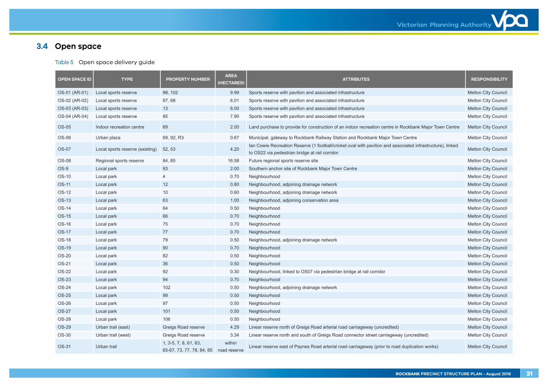
3.4 Open space
Table 5 Open space delivery guide
OPEN SPACE ID TYPE PROPERTY NUMBERAREA
(HECTARES)ATTRIBUTES RESPONSIBILITY
OS-01 (AR-01) Local sports reserve 98, 102 9.99 Sports reserve with pavilion and associated infrastructure Melton City Council
OS-02 (AR-02) Local sports reserve 67, 68 6.01 Sports reserve with pavilion and associated infrastructure Melton City Council
OS-03 (AR-03) Local sports reserve 13 6.00 Sports reserve with pavilion and associated infrastructure Melton City Council
OS-04 (AR-04) Local sports reserve 85 7.90 Sports reserve with pavilion and associated infrastructure Melton City Council
OS-05 Indoor recreation centre 69 2.00 Land purchase to provide for construction of an indoor recreation centre in Rockbank Major Town Centre Melton City Council
OS-06 Urban plaza 69, 92, R3 0.67 Municipal, gateway to Rockbank Railway Station and Rockbank Major Town Centre Melton City Council
OS-07 Local sports reserve (existing) 52, 53 4.20Ian Cowie Recreation Reserve (1 football/cricket oval with pavilion and associated infrastructure), linked to OS22 via pedestrian bridge at rail corridor
Melton City Council
OS-08 Regional sports reserve 84, 85 16.58 Future regional sports reserve site Melton City Council
OS-9 Local park 93 2.00 Southern anchor site of Rockbank Major Town Centre Melton City Council
OS-10 Local park 4 0.70 Neighbourhood Melton City Council
OS-11 Local park 12 0.80 Neighbourhood, adjoining drainage network Melton City Council
OS-12 Local park 10 0.60 Neighbourhood, adjoining drainage network Melton City Council
OS-13 Local park 63 1.00 Neighbourhood, adjoining conservation area Melton City Council
OS-14 Local park 64 0.50 Neighbourhood Melton City Council
OS-15 Local park 66 0.70 Neighbourhood Melton City Council
OS-16 Local park 75 0.70 Neighbourhood Melton City Council
OS-17 Local park 77 0.70 Neighbourhood Melton City Council
OS-18 Local park 79 0.50 Neighbourhood, adjoining drainage network Melton City Council
OS-19 Local park 90 0.70 Neighbourhood Melton City Council
OS-20 Local park 82 0.50 Neighbourhood Melton City Council
OS-21 Local park 36 0.50 Neighbourhood Melton City Council
OS-22 Local park 92 0.30 Neighbourhood, linked to OS07 via pedestrian bridge at rail corridor Melton City Council
OS-23 Local park 94 0.70 Neighbourhood Melton City Council
OS-24 Local park 102 0.50 Neighbourhood, adjoining drainage network Melton City Council
OS-25 Local park 99 0.50 Neighbourhood Melton City Council
OS-26 Local park 97 0.50 Neighbourhood Melton City Council
OS-27 Local park 101 0.50 Neighbourhood Melton City Council
OS-28 Local park 106 0.50 Neighbourhood Melton City Council
OS-29 Urban trail (east) Greigs Road reserve 4.29 Linear reserve north of Greigs Road arterial road carriageway (uncredited) Melton City Council
OS-30 Urban trail (west) Greigs Road reserve 3.34 Linear reserve north and south of Greigs Road connector street carriageway (uncredited) Melton City Council
OS-31 Urban trail1, 3-5, 7, 8, 61, 63, 65-67, 73, 77, 78, 84, 85
within road reserve
Linear reserve east of Paynes Road arterial road carriageway (prior to road duplication works) Melton City Council
ROCKBANK PRECINCT STRUCTURE PLAN - August 2016 31
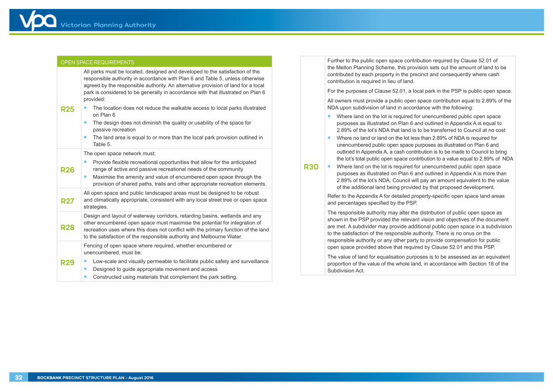
OPEN SPACE REQUIREMENTS
R25
All parks must be located, designed and developed to the satisfaction of the responsible authority in accordance with Plan 6 and Table 5, unless otherwise agreed by the responsible authority. An alternative provision of land for a local park is considered to be generally in accordance with that illustrated on Plan 6 provided:
• The location does not reduce the walkable access to local parks illustrated on Plan 6
• The design does not diminish the quality or usability of the space for passive recreation
• The land area is equal to or more than the local park provision outlined in Table 5.
R26
The open space network must:
• Provide flexible recreational opportunities that allow for the anticipated range of active and passive recreational needs of the community
• Maximise the amenity and value of encumbered open space through the provision of shared paths, trails and other appropriate recreation elements.
R27 All open space and public landscaped areas must be designed to be robust and climatically appropriate, consistent with any local street tree or open space strategies.
R28
Design and layout of waterway corridors, retarding basins, wetlands and any other encumbered open space must maximise the potential for integration of recreation uses where this does not conflict with the primary function of the land to the satisfaction of the responsible authority and Melbourne Water.
R29
Fencing of open space where required, whether encumbered or unencumbered, must be:
• Low-scale and visually permeable to facilitate public safety and surveillance• Designed to guide appropriate movement and access• Constructed using materials that complement the park setting.
R30
Further to the public open space contribution required by Clause 52.01 of the Melton Planning Scheme, this provision sets out the amount of land to be contributed by each property in the precinct and consequently where cash contribution is required in lieu of land.
For the purposes of Clause 52.01, a local park in the PSP is public open space.
All owners must provide a public open space contribution equal to 2.89% of the NDA upon subdivision of land in accordance with the following:
• Where land on the lot is required for unencumbered public open space purposes as illustrated on Plan 6 and outlined in Appendix A is equal to 2.89% of the lot’s NDA that land is to be transferred to Council at no cost
• Where no land or land on the lot less than 2.89% of NDA is required for unencumbered public open space purposes as illustrated on Plan 6 and outlined in Appendix A, a cash contribution is to be made to Council to bring the lot’s total public open space contribution to a value equal to 2.89% of NDA
• Where land on the lot is required for unencumbered public open space purposes as illustrated on Plan 6 and outlined in Appendix A is more than 2.89% of the lot’s NDA, Council will pay an amount equivalent to the value of the additional land being provided by that proposed development.
Refer to the Appendix A for detailed property-specific open space land areas and percentages specified by the PSP.
The responsible authority may alter the distribution of public open space as shown in the PSP provided the relevant vision and objectives of the document are met. A subdivider may provide additional public open space in a subdivision to the satisfaction of the responsible authority. There is no onus on the responsible authority or any other party to provide compensation for public open space provided above that required by Clause 52.01 and this PSP.
The value of land for equalisation purposes is to be assessed as an equivalent proportion of the value of the whole land, in accordance with Section 18 of the Subdivision Act.
32 ROCKBANK PRECINCT STRUCTURE PLAN - August 2016

OPEN SPACE GUIDELINES
G21 Local parks should cater for a broad range of users by providing a mix of spaces and planting to support both structured and unstructured recreational activities and play opportunities for all ages and abilities.
G22 Where possible, any existing vegetation should be protected and enhanced through open space networks to facilitate habitat and movement corridors for species found throughout the surrounding region.
G23 Open spaces should have a road frontage to all edges except when abutting a community hub or drainage reserve, or where housing fronts open space with a paper road to the satisfaction of the responsible authority.
G24 Crime prevention through environmental design (CPTED) principles should guide the design of open spaces and associated infrastructure.
ROCKBANK PRECINCT STRUCTURE PLAN - August 2016 33

42
43
3
12
4
5
7
8
6
10
11
9
12
13
14
17-E18-E19-E
20-E21-E22-E
23-E24 25 26272930313233
34
28
36 3738
39
404445 46
4748
4950
51
5253 54
55
57
56 58
59 60
61
62
63
64
67
R2-
R3-
R4-
R5-
66
65
68
69
7172
73
7475 76
77
7879
80
81 82
83
84
85
86
87
88
89
90
92
93
94
95
96
9897
99101
102
103
104 105 106
107
109
108
110
35
41
15-E
16-E
70
R1-
113
R6-
91
112
111
100
112
OLD
LEA
KES
RD
PAYN
ES R
D
TRO
UPS
RD
NTH
WESTERN FREEWAY
GREIGS RD
WESTCOTT PDE
STEWART CRES
LEA
KES
RD
LEA
KES
RD
DO
WN
ING
ST
TRO
UPS
RD
STH
FAU
LKN
ER R
D
MURRAY RD
TOOLERN RDIRAMOO CIRCUIT
Melbourne-Ballarat rail corridor
RockbankTownship
LEO
NID
DR
precinct boundary
native vegetation to be retained
native vegetation that can be removed
public acquisition overlay (PAO)
scattered trees that can be removed
scattered trees to be retained
property boundary & number7
NOTE : Future construction of Greigs Road be undertaken in a manner that causes minimum disruption to remnant native vegetation
Rockbank Precinct Structure Plan
Copyright, Victorian Planning Authority, 2016 The state of Victoria does not warrant the accuracy or completeness of information in this publication and any person using or relying upon such information does so on the basis that the State of Victoria shall bear no responsibility or liability whatsoever for any errors, faults, defects or omission in the information.
1:25,000 @ A4
0 200 400 600 800 1,000m
Plan 7 - Native Vegetation Retention & Removal
34 ROCKBANK PRECINCT STRUCTURE PLAN - August 2016

3.5 Biodiversity & threatened species
BIODIVERSITY AND THREATENED SPECIES REQUIREMENTS
R31 Native vegetation must be retained as illustrated on Plan 7 unless otherwise agreed by the responsible authority.
ROCKBANK PRECINCT STRUCTURE PLAN - August 2016 35

OLD
LEA
KES
RD
PAYN
ES R
D
TRO
UPS
RD
NTH
WESTERN FREEWAY
GREIGS RD
WESTCOTT PDE
LEA
KES
RD
LEA
KES
RD
ROCK
BAN
K RD
TOOLERN RD
Melbourne-Ballarat rail corridor
RockbankTownship
DO
WN
ING
ST
TRO
UPS
RD
STH
FAU
LKN
ER R
D
MURRAY RD
IRAMOO CIRCUIT
STEWART CRES
LEO
NID
DR
PAYN
ES R
D
TRO
UPS
RD
NTH
WESTERN FREEWAY
GREIGS RD
WESTCOTT PDE
OLD
LEA
KES
RD
LEA
KES
RD
LEA
KES
RD
ROCK
BAN
K RD
TOOLERN RD
Melbourne-Ballarat rail corridor
RockbankTownship
MO
UN
T CO
TTRE
LL R
D
OU
TER
MET
ROPO
LITA
N R
ING
TRA
NSP
ORT
CO
RRID
OR
(OM
R)
precinct boundary
arterial road (six lanes)
arterial road (four lanes)
boulevard connector street
connector street
key local access street
rail interface street
potential noise amenity interface
signalised intersection
level crossing and road (interim only)
grade separation (ultimate)
freeway
outer metropolitan ring transport corridor (OMR)
NOTE : Road names are indicative and subject to an o�cial naming process.
Rockbank Precinct Structure Plan
Copyright, Victorian Planning Authority, 2016 The state of Victoria does not warrant the accuracy or completeness of information in this publication and any person using or relying upon such information does so on the basis that the State of Victoria shall bear no responsibility or liability whatsoever for any errors, faults, defects or omission in the information.
1:25,000 @ A4
0 200 400 600 800 1,000m
Plan 8 - Road Network Plan
36 ROCKBANK PRECINCT STRUCTURE PLAN - August 2016

3.6 Transport & movement
3.6.1 Town centre transport, access & connectivity
TOWN CENTRE TRANSPORT, ACCESS & CONNECTIVITY REQUIREMENTS
R32 Heavy vehicle movements (loading and deliveries) must not front high streets and should be located to the rear and/or side street and be sleeved or screened.
R33 High streets must be designed for a low speed environment of 30km/h or less such that vehicles and cyclists share the carriageway and pedestrians can safely cross the road.
R34 Pedestrian movement must be prioritised in the design of high streets whilst maintaining local traffic access and movements.
R35 Safe and easy access for pedestrian and cycle trips must be provided to the town centre through the layout and design of the surrounding street network.
R36 Transport routes, hubs and stops must be located to facilitate access to key destinations and generate activity in the town centre.
R37 Car park entrances directly from high streets must be minimised and alternative access must be provided from other streets.
R38 Bicycle parking must be provided at entry points to the town centre and designed to provide weather protection, passive surveillance and lighting to the satisfaction of the responsible authority.
TOWN CENTRE TRANSPORT, ACCESS & CONNECTIVITY GUIDELINES
G25 Pedestrian priority should be provided across all side roads along main streets and all car park entrances.
G26 Increased permeability in the road network within and surrounding the town centre should be delivered via shorter block lengths and the avoidance of culs-de-sac.
G27 Pedestrian movements should be prioritised by providing links between key destinations within the town centre.
G28 Car parking should be provided efficiently through use of shared, consolidated parking areas.
G29 Safe pedestrian access should be provided throughout all car parking areas.
G30 Pedestrian permeability and off road connections through the town centre should be encouraged.
3.6.2 Street network
STREET NETWORK REQUIREMENTS
R39
Subdivision layouts must provide:
• A permeable and safe street network for walking and cycling• A safe and low speed street network that encourages walking and cycling• Convenient access to local points of interest and destinations for the
effective integration with neighbouring properties.
R40 Configuration of vehicle access to lots from a public street must ensure that there is sufficient separation between crossovers to allow for a minimum of one on-street car park for every two residential lots.
R41 Vehicle access to lots fronting arterial roads must be provided from a local internal loop road, rear lane or service road to the satisfaction of the road authority.
R42 Streets must be constructed to property boundaries where an inter-parcel connection is intended or indicated in the PSP by any date or stage of development required by the responsible authority.
R43 Where a lot is 7.5 metres or less in width, vehicle access must be via a rear laneway, unless otherwise approved by the responsible authority.
R44 Development must positively address all waterways through the use of frontage roads or lots with a direct frontage to the satisfaction of Melbourne Water and the responsible authority.
R45 Roundabouts, where determined to be required at cross road intersections, must be designed to slow vehicles, provide for pedestrian visibility and safety, and ensure connectivity and continuity of shared paths and bicycle paths.
R46
Where a connector street crosses a waterway as illustrated on Plan 8, the development proponent must construct an appropriate vehicle crossing prior to the issue of statement of compliance for the initial stage of subdivision on the opposite side of the waterway, whether or not that residential subdivision directly abuts the waterway.
R47 Road networks and street types must be designed and developed in accordance with the street cross sections outlined in Appendix B unless otherwise agreed by the responsible authority.
ROCKBANK PRECINCT STRUCTURE PLAN - August 2016 37

THIS PAGE HAS BEEN LEFT INTENTIONALLY BLANK
38 ROCKBANK PRECINCT STRUCTURE PLAN - August 2016

R48
Where utilised, alternative street cross sections such as outlined in Appendix C must ensure that:
• Minimum required carriageway dimensions are maintained to ensure safe and efficient operation of emergency vehicles on all streets as well as buses on connector streets
• The performance characteristics of standard street cross sections as they relate to pedestrian and cycling use are maintained
• Relevant minimum road reserve widths for the type of street are maintained as outlined in Appendix B.
R49 Any changes required to the design of roads and intersections in the PSP at the time of development must be accommodated within the land take as illustrated on Plan 4 and outlined in Appendix A.
STREET NETWORK GUIDELINES
G31
Approximately 30% of streets (including connector streets) within a subdivision should apply an alternative cross section to the standard street cross sections outlined in Appendix B to the satisfaction of the responsible authority. Examples of potential variations are outlined in Appendix C; however, other non-standard variations are encouraged but not limited to:
• Varied street tree placement• Varied footpath or carriageway placement• Varied carriageway or parking bay pavement material• Introduction of elements to create a boulevard effect• Differing tree outstand treatments.
G32 Street layouts should provide multiple convenient routes to key destinations such as schools, community facilities, sports reserves and Rockbank Major Town Centre.
G33 Street block lengths should not exceed 240 metres to ensure a safe, permeable and low speed environment for pedestrians, cyclists and vehicles is achieved.
G34 Culs-de-sac should not detract from convenient pedestrian, cycle and vehicular connections.
G35
The frequency of vehicular crossovers on widened verges (a verge in excess of six metres) should be minimised through the use of a combination of:
• Rear loaded lots with laneway access• Vehicular access from the side of a lot• Combined or grouped crossovers• Increased lot widths.
G36
Slip lanes should be avoided in areas of high pedestrian activity and only be provided at any other intersection between connector streets and arterial roads where they are necessitated by high traffic volumes to the satisfaction of the coordinating road authority.
G37 Alignment of future primary arterial roads may be altered so long as the intended performance and function of the roads are maintained to the satisfaction of the coordinating road authority and the responsible authority.
G38 Streets should be the primary interface between development and waterways, with open space and lots with a direct frontage allowed only as a minor component of the waterway interface.
G39
Where lots with direct frontage are proposed, they should be set back five metres from the waterway corridor to provide pedestrian and service vehicle access to those lots to the satisfaction of Melbourne Water and the responsible authority.
G40 All signalised intersections should be designed in accordance with the VicRoads’ Growth Areas Handbook - A guide to transport planning in growth areas.
ROCKBANK PRECINCT STRUCTURE PLAN - August 2016 39

OLD
LEA
KES
RD
PAYN
ES R
D
TRO
UPS
RD
NTH
WESTERN FREEWAY
GREIGS RD
WESTCOTT PDE
LEA
KES
RD
LEA
KES
RD
ROCK
BAN
K RD
TOOLERN RD
Melbourne-Ballarat rail corridor
RockbankTownship
DO
WN
ING
ST
TRO
UPS
RD
STH
FAU
LKN
ER R
D
MURRAY RD
IRAMOO CIRCUIT
STEWART CRES
LEO
NID
DR
PAYN
ES R
D
TRO
UPS
RD
NTH
WESTERN FREEWAY
GREIGS RD
WESTCOTT PDE
OLD
LEA
KES
RD
LEA
KES
RD
LEA
KES
RD
ROCK
BAN
K RD
TOOLERN RD
railway noise amenity area
railway noise amenity area
NOTE : Potential location for rail stabling subject to investigation
precinct boundary
rockbank railway station
rockbank railway station precinct
rail corridor
rail stabling
outer metropolitan transport corridor (OMR)
railway noise amenity area
signalised intersection
bus capable road (arterial)
bus capable road (other)
potential bus priority link
o�-road bike path & pedestrian path
shared path
pedestrian bridge (rail)
potential pedestrian bridge (rail)
potential pedestrian bridge (freeway)
freeway
Melbourne-Ballarat rail corridor
DO
WN
ING
ST
Rockbank Precinct Structure Plan
Copyright, Victorian Planning Authority, 2016 The state of Victoria does not warrant the accuracy or completeness of information in this publication and any person using or relying upon such information does so on the basis that the State of Victoria shall bear no responsibility or liability whatsoever for any errors, faults, defects or omission in the information.
1:25,000 @ A4
0 200 400 600 800 1,000m
Plan 9 - Public Transport & Path Network
40 ROCKBANK PRECINCT STRUCTURE PLAN - August 2016

3.6.3 Public transport
PUBLIC TRANSPORT REQUIREMENTS
R50 The street network must be designed to ensure all households are able to directly and conveniently walk to public transport services.
R51 Subdivision design must deliver an active interface to the rail corridor by provision of a local access street with landscape buffers and continuous shared path to the satisfaction of the responsible authority.
R52 Bus stop facilities must be designed as an integral part of activity generating land uses such as schools, community facilities, sports reserves and the Rockbank Major Town Centre.
R53 Roads and intersections shown as bus capable on Plan 9 must be constructed to accommodate ultra-low-floor buses to the satisfaction of Public Transport Victoria and the responsible authority.
R54 Subdivision design must show the location of all bus stops to the satisfaction of Public Transport Victoria.
R55
Visually transparent fencing along the boundary abutting the rail reserve must be provided in accordance with V/Line standards for fencing, unless an alternative treatment is appropriate to address acoustic requirements within the railway noise amenity area, to the satisfaction of Public Transport Victoria and VicTrack.
3.6.4 Walking & cycling
WALKING & CYCLING REQUIREMENTS
R56
Design of all streets and arterial roads must give priority to the requirements of pedestrians and cyclists by providing:
• Footpaths on both sides of all streets and roads unless otherwise specified by the PSP
• Footpaths connecting bus stops and the surrounding pedestrian network• Shared paths or bicycle paths where illustrated on Plan 9 or as shown on
the relevant cross sections outlined in Appendix B or as specified in another requirement in the PSP
• Safe, accessible and convenient crossing points of connector and local streets at all intersections and at key desire lines and locations of high amenity (refer to the Greenfield Engineering Design and Construction Manual for typical intersection treatments)
• Pedestrian and cyclist priority crossings on all slip lanes• Safe and convenient transition between on- and off-road bicycle networks. • Safe and convenient transition between shared paths and bicycle paths on
arterial roads and connector streets.
All to the satisfaction of the coordinating road authority and the responsible authority.
R57
Shared and pedestrian paths along waterways must be constructed to a standard that satisfies the requirements of Melbourne Water and the responsible authority, and must be:
• Delivered by development proponents consistent with the network as illustrated on Plan 9
• Positioned above 1:10 year flood levels with a crossing of the waterway designed above 1:100 year flood level to maintain hydraulic function of the waterway
• Positioned above 1:100 year flood level where direct access is provided to the dwelling from the waterway.
R58 Pedestrian and cycle path networks must be permeable and linked to key destinations throughout the precinct, including Rockbank Major Town Centre and local convenience centres.
R59 Safe, accessible and convenient pedestrian and cycle crossing points must be provided at all intersections, key desire lines and locations of high amenity.
R60
Bicycle priority at intersections of minor streets and connector streets with dedicated off-road bicycle paths must be achieved through strong and consistent visual and physical clues and supportive directional and associated road signs.
R61 Alignment of the off-road bicycle path must be designed for cyclists to travel up to 30km/h to the satisfaction of the responsible authority.
R62 Bicycle parking facilities must be provided by development proponents in convenient locations at key destinations such as Rockbank Major Town Centre and across the open space network.
R63 A shared path must be continuously provided along frontages to the rail corridor and proposed rail stabling as illustrated on Plan 9.
R64 Pedestrian bridges must be provided in accordance with Plan 9 to provide pedestrian connectivity throughout the precinct.
R65 Pedestrian and bicycle paths must connect to the pedestrian overpass structures of the rail corridor and freeway.
R66 Appropriately scaled lighting must be installed along all major pedestrian thoroughfares traversing public open space and along cycling networks to the satisfaction of the responsible authority.
ROCKBANK PRECINCT STRUCTURE PLAN - August 2016 41

OLD
LEA
KES
RD
PAYN
ES R
D
TRO
UPS
RD
NTH
WESTERN FREEWAY
GREIGS RD
WESTCOTT PDE
LEA
KES
RD
LEA
KES
RD
ROCK
BAN
K RD
TOOLERN RD
Melbourne-Ballarat rail corridor
RockbankTownship
DO
WN
ING
ST
TRO
UPS
RD
STH
FAU
LKN
ER R
D
MURRAY RD
IRAMOO CIRCUIT
STEWART CRES
LEO
NID
DR
WL01WL01
WL11WL11
WL02WL02
WL12WL12
WL13WL13
WL17WL17
WL06WL06
WL04WL04
WL14WL14WL15WL15
WL03WL03
WL05WL05
WL09WL09
WL07WL07
WL10WL10
WL08WL08
WL16WL16
NOTE:Stormwater quality treatment assets illustrated on this plan are subject to con�rmation through preparation of Melbourne Water Development Services Schemes and through detailed design to the satisfaction of Melbourne Water.
precinct boundary
constructed waterway corridor / drainage asset
conservation area - lignum swamp
0.5m contours
stormwater quality treatment asset (indicative location)
opportunity to utilise water from adjacent stormwater quality treatment asset to irrigate active open space
opportunity to capture water from adjacent stormwater quality treatment asset and treat to higher level for distribution through the recycled water network
stormwater drainage & water quality treatment infrastructure (refer table 6)
WL4WL4
Rockbank Precinct Structure Plan
Copyright, Victorian Planning Authority, 2016 The state of Victoria does not warrant the accuracy or completeness of information in this publication and any person using or relying upon such information does so on the basis that the State of Victoria shall bear no responsibility or liability whatsoever for any errors, faults, defects or omission in the information.
1:25,000 @ A4
0 200 400 600 800 1,000m
Plan 10 - Integrated Water Management
42 ROCKBANK PRECINCT STRUCTURE PLAN - August 2016
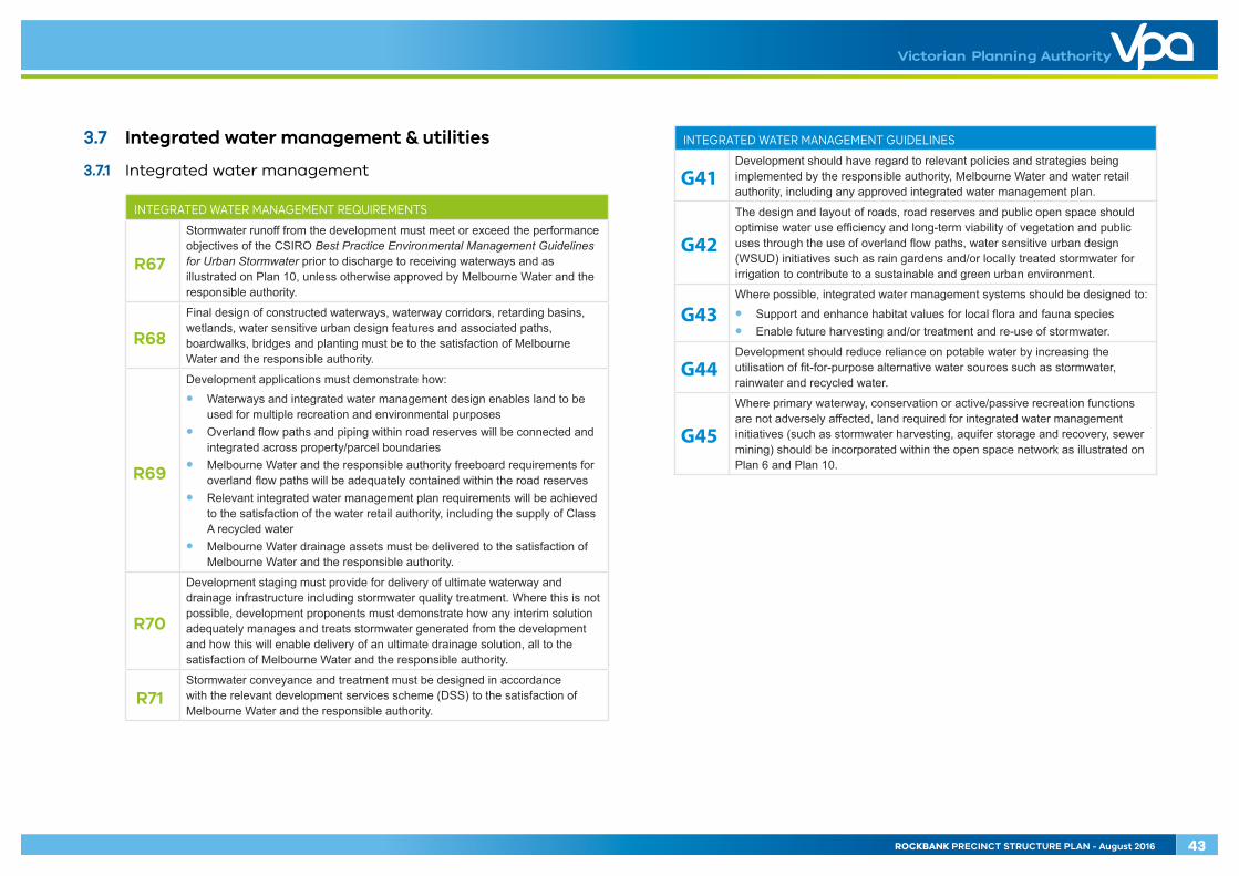
3.7 Integrated water management & utilities
3.7.1 Integrated water management
INTEGRATED WATER MANAGEMENT REQUIREMENTS
R67
Stormwater runoff from the development must meet or exceed the performance objectives of the CSIRO Best Practice Environmental Management Guidelines for Urban Stormwater prior to discharge to receiving waterways and as illustrated on Plan 10, unless otherwise approved by Melbourne Water and the responsible authority.
R68
Final design of constructed waterways, waterway corridors, retarding basins, wetlands, water sensitive urban design features and associated paths, boardwalks, bridges and planting must be to the satisfaction of Melbourne Water and the responsible authority.
R69
Development applications must demonstrate how:
• Waterways and integrated water management design enables land to be used for multiple recreation and environmental purposes
• Overland flow paths and piping within road reserves will be connected and integrated across property/parcel boundaries
• Melbourne Water and the responsible authority freeboard requirements for overland flow paths will be adequately contained within the road reserves
• Relevant integrated water management plan requirements will be achieved to the satisfaction of the water retail authority, including the supply of Class A recycled water
• Melbourne Water drainage assets must be delivered to the satisfaction of Melbourne Water and the responsible authority.
R70
Development staging must provide for delivery of ultimate waterway and drainage infrastructure including stormwater quality treatment. Where this is not possible, development proponents must demonstrate how any interim solution adequately manages and treats stormwater generated from the development and how this will enable delivery of an ultimate drainage solution, all to the satisfaction of Melbourne Water and the responsible authority.
R71 Stormwater conveyance and treatment must be designed in accordance with the relevant development services scheme (DSS) to the satisfaction of Melbourne Water and the responsible authority.
INTEGRATED WATER MANAGEMENT GUIDELINES
G41 Development should have regard to relevant policies and strategies being implemented by the responsible authority, Melbourne Water and water retail authority, including any approved integrated water management plan.
G42
The design and layout of roads, road reserves and public open space should optimise water use efficiency and long-term viability of vegetation and public uses through the use of overland flow paths, water sensitive urban design (WSUD) initiatives such as rain gardens and/or locally treated stormwater for irrigation to contribute to a sustainable and green urban environment.
G43 Where possible, integrated water management systems should be designed to:
• Support and enhance habitat values for local flora and fauna species• Enable future harvesting and/or treatment and re-use of stormwater.
G44 Development should reduce reliance on potable water by increasing the utilisation of fit-for-purpose alternative water sources such as stormwater, rainwater and recycled water.
G45
Where primary waterway, conservation or active/passive recreation functions are not adversely affected, land required for integrated water management initiatives (such as stormwater harvesting, aquifer storage and recovery, sewer mining) should be incorporated within the open space network as illustrated on Plan 6 and Plan 10.
ROCKBANK PRECINCT STRUCTURE PLAN - August 2016 43
THIS PAGE HAS BEEN LEFT INTENTIONALLY BLANK
44 ROCKBANK PRECINCT STRUCTURE PLAN - August 2016

Table 6 Stormwater drainage & water quality treatment infrastructure delivery guide
WATER INFRASTRUCTURE
ID LAND USE PROPERTY
NUMBERAREA
(HECTARES)
WIDTHS (METRES) MIN-MAX WITH
FRONTAGE ROADS [MIN-MAX WITH NO FRONTAGE ROAD]
ATTRIBUTES RESPONSIBILITY
WI01 Wetland / drainage 12, 13 5.15 - Imaroo Circuit Development Services Scheme Melbourne Water
WI02 Wetland / drainage 13, 15-E 1.26 - Imaroo Circuit Development Services Scheme Melbourne Water
WI03 Wetland / drainage 87 0.62 - Leakes Road Development Services Scheme Melbourne Water
WI04 Wetland / drainage 76 4.93 - Leakes Road Development Services Scheme Melbourne Water
WI05 Wetland / drainage 91 3.49 - Leakes Road Development Services Scheme Melbourne Water
WI06 Wetland / drainage 38, 39 1.91 - Rockbank Township Development Services Scheme Melbourne Water
WI07 Wetland / drainage 102 3.54 - Leakes Road Development Services Scheme Melbourne Water
WI08 Wetland / drainage 102, 103 2.64 - Leakes Road Development Services Scheme Melbourne Water
WI09 Wetland / drainage 59 0.11 - Rockbank Township Development Services Scheme Melbourne Water
WI10 Wetland / drainage 107, 109 10.50 - Leakes Road Development Services Scheme Melbourne Water
WI11 Waterway 13 1.64 45 [55] Imaroo Circuit Development Services Scheme Melbourne Water
WI12 Waterway 10, 12, 111 2.60 45 [55] Imaroo Circuit Development Services Scheme Melbourne Water
WI13 Waterway 62-64, 67, 68, 73, 74, 111, R1
12.12 45-50 [55-60] Imaroo Circuit Development Services Scheme Melbourne Water
WI14 Waterway 79-81, 113 4.82 45-50 [55-60] Leakes Road Development Services Scheme Melbourne Water
WI15 Waterway 94-96, 98, 102, R3 9.44 45-55 [55-60] Leakes Road Development Services Scheme Melbourne Water
WI16 Waterway 107 0.86 45 [55] Leakes Road Development Services Scheme Melbourne Water
WI17 Local conservation 63 9.19 - Lignum swamp Melton City Council
Note: The areas and corridor widths identified in this table are subject to refinement during detailed design to the satisfaction of Melbourne Water and the responsible authority.
ROCKBANK PRECINCT STRUCTURE PLAN - August 2016 45