Embed Size (px)
Citation preview
Planning SchemeRockhampton Region
Growing a stronger future
Flood Hazard Overlays
What are overlays?Overlays are provided in the Planning Scheme to indicate areas that are subject to a natural hazard such as bushfire, flooding or landslide, a value such as biodiversity or heritage or a constraint such as proximity to high impact industry or an airport.
The Planning Scheme contains additional requirements that must be addressed for development within an overlay area. Overlays are made up of two elements; a written component (code) and maps that indicate the areas and places that may be sensitive to the effects of development, have hazard constraints or contain valuable resources which call for additional assessment criteria. Not all properties are subject to overlays, however some may be affected by more than one overlay (for example bushfire and steep land overlays). If a property is affected by an overlay it means that any proposed future use must address, as part of the assessment, any specific requirements outlined in the overlay code that are affecting the property.
What is a flood overlay?The flood hazard overlay maps provide detailed information on areas that have been or could be impacted by flooding. Provisions detailed in the Planning Scheme for properties identified in the overlay maps ensure new development and redevelopment either avoids, or becomes increasingly resilient to flood risk.
This will be achieved by:
• Progressivelyreducingtheintensityofdevelopmentinfloodhazardareasovertime;
• Avoidingthefurthersubdivisionoflandforurbanuseswithinfloodhazardareas;
• Retainingfloodhazardareasforruralactivities,outdoorsportandrecreation,parkandenvironmental uses, and other extremely low intensity uses that are able to function without risk to life or property or require major repair immediately after a flood event; and
• Locatingstrategiccommunityfacilitiesandsupportinginfrastructureandservicesthatarerequired during an emergency, outside and significantly above land mapped as a flood hazard area.
Flood Hazard Overlays
About the Rockhampton Region Planning SchemeAplanningschemeisadocumentthatidentifies how land should be used and what type of new development is supported by Council. Council uses a planning scheme like an instruction manual to guide land use outcomes and development in our local
governmentarea.TheRockhamptonRegionPlanning Scheme provides a consistent approach to the management of land and has been prepared in accordance with the Sustainable Planning Act 2009.
The Rockhampton Region Planning Scheme replaces the Fitzroy Shire, Mount Morgan Shire and Rockhampton City Planning Schemes.
Development within flood hazard areasWhile recognising the need for new development, Council has a duty of care to protect the safety of the community and minimise property impacts from flooding. The flood overlay code provides clear guidance for any future development in flood affected areas.
The purpose of the flood hazard overlay code is to:
• Managedevelopmentsothatriskto life, property, community and environment is mitigated;
• Considerhowdevelopmentcanbe designed and sited to be more resilient to flooding;
• Locatenewurbangrowthinfloodfree areas or where the effects of flooding can be properly managed; and
• Toplannowforthepossibleimpactof changing weather patterns such as more intense cyclones, more intense rainfall events and rising sea levels.
Flood Hazard OverlaysROCKHAMPTON REGION PLANNING SCHEME
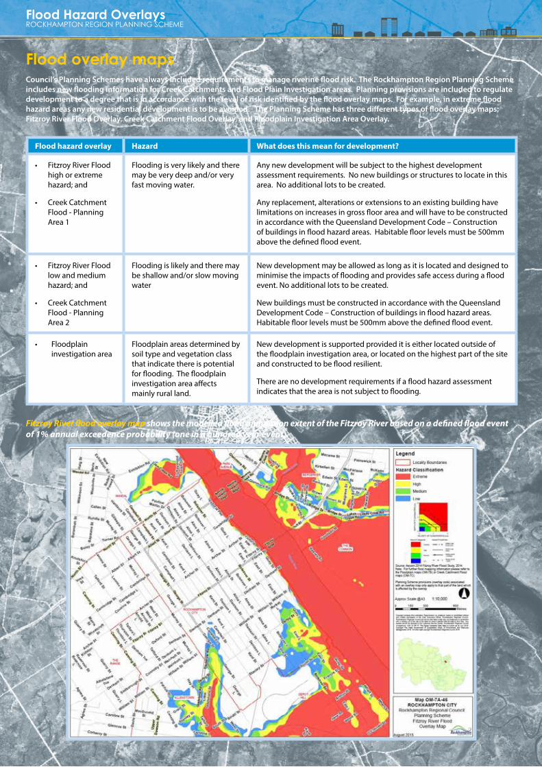
Flood hazard overlay Hazard What does this mean for development?
• FitzroyRiverFloodhigh or extreme hazard; and
• Creek Catchment Flood - Planning Area1
Flooding is very likely and there may be very deep and/or very fast moving water.
Anynewdevelopmentwillbesubjecttothehighestdevelopmentassessment requirements. No new buildings or structures to locate in this area. No additional lots to be created.
Anyreplacement,alterationsorextensionstoanexistingbuildinghavelimitations on increases in gross floor area and will have to be constructed in accordance with the Queensland Development Code – Construction of buildings in flood hazard areas. Habitable floor levels must be 500mm above the defined flood event.
• FitzroyRiverFloodlow and medium hazard; and
• Creek Catchment Flood - Planning Area2
Flooding is likely and there may be shallow and/or slow moving water
New development may be allowed as long as it is located and designed to minimise the impacts of flooding and provides safe access during a flood event. No additional lots to be created.
New buildings must be constructed in accordance with the Queensland Development Code – Construction of buildings in flood hazard areas. Habitable floor levels must be 500mm above the defined flood event.
• Floodplain investigation area
Floodplain areas determined by soil type and vegetation class that indicate there is potential for flooding. The floodplain investigation area affects mainly rural land.
New development is supported provided it is either located outside of the floodplain investigation area, or located on the highest part of the site and constructed to be flood resilient.
There are no development requirements if a flood hazard assessment indicates that the area is not subject to flooding.
Flood overlay mapsCouncil’s Planning Schemes have always included requirements to manage riverine flood risk. The Rockhampton Region Planning Scheme includes new flooding information for Creek Catchments and Flood Plain Investigation areas. Planning provisions are included to regulate development to a degree that is in accordance with the level of risk identified by the flood overlay maps. For example, in extreme flood hazard areas any new residential development is to be avoided. The Planning Scheme has three different types of flood overlay maps; Fitzroy River Flood Overlay, Creek Catchment Flood Overlay, and Floodplain Investigation Area Overlay.
Fitzroy River flood overlay map shows the modelled flood inundation extent of the Fitzroy River based on a defined flood event of 1% annual exceedence probability (one in a hundred year event).

Flood Hazard OverlaysROCKHAMPTON REGION PLANNING SCHEME
Flood hazard overlay Hazard What does this mean for development?
• FitzroyRiverFloodhigh or extreme hazard; and
• Creek Catchment Flood - Planning Area1
Flooding is very likely and there may be very deep and/or very fast moving water.
Anynewdevelopmentwillbesubjecttothehighestdevelopmentassessment requirements. No new buildings or structures to locate in this area. No additional lots to be created.
Anyreplacement,alterationsorextensionstoanexistingbuildinghavelimitations on increases in gross floor area and will have to be constructed in accordance with the Queensland Development Code – Construction of buildings in flood hazard areas. Habitable floor levels must be 500mm above the defined flood event.
• FitzroyRiverFloodlow and medium hazard; and
• Creek Catchment Flood - Planning Area2
Flooding is likely and there may be shallow and/or slow moving water
New development may be allowed as long as it is located and designed to minimise the impacts of flooding and provides safe access during a flood event. No additional lots to be created.
New buildings must be constructed in accordance with the Queensland Development Code – Construction of buildings in flood hazard areas. Habitable floor levels must be 500mm above the defined flood event.
• Floodplain investigation area
Floodplain areas determined by soil type and vegetation class that indicate there is potential for flooding. The floodplain investigation area affects mainly rural land.
New development is supported provided it is either located outside of the floodplain investigation area, or located on the highest part of the site and constructed to be flood resilient.
There are no development requirements if a flood hazard assessment indicates that the area is not subject to flooding.
Creek catchment flood overlay map includes Planning Area 1 which represents the modelled inundation extent of an extreme hazard level creek flood and Planning Area 2 represents a combined modelled inundation extent of the high, medium and low hazard. This modelling is based on a defined flood event of 1% annual exceedence probability (one in a hundred year event).
Floodplain investigation area map represents indicative floodplain areas that could be affected by flooding (based on interim mapping completed by the Queensland Reconstruction Authority).
Flood Hazard Overlays
Flood Hazard Overlays
Different types of floodingRiver Flooding RiverfloodingiscausedbywidespreadandprolongedrainfalloverthecatchmentareaoftheFitzroyRiver.Astheriver reaches capacity, excess water overflows its banks and onto the floodplain. The community generally receives many days notice of significant river flooding and is able to prepare for impacts in urban areas. The impacts can be felt for many weeks through inundation, isolation and recovery efforts.TheRegionexperiencedmajorFitzroyRiverfloodsin1918,1954,1991,2008,2011and2013.
Creek Flooding Creek flooding is caused by significant rainfall events in local creek catchments. Creeks can rise quickly, become fast flowing and recede very quickly, with little warning. Due to the limited warning, this type of flooding can present a greater risk to life than river flooding. Creek catchments inNorthRockhampton,Bajool,StanwellandKabraexperiencedsignificantcreekfloodinginJanuary2013dueto ex Tropical Cyclone Oswald.
Stormwater Overland Flow Flooding Stormwater and overland flow flooding is caused by significant rainfall events when water flows across the ground or rises naturally from underground. During and after heavy rain, water may also cause stormwater infrastructure to overflow, resulting in overland flow flooding. The impact of overland flooding is usually of short duration with water generally draining, either directly or via anaturalwatercourse,totheFitzroyRiver.
Storm Tide Flooding Storm tide flooding is caused when a storm surge, generally related to cyclonic activity, creates higher than normal sea levels. Flooding can also occur from king tides which are predictable events occurring twice a year; once in summer and once in winter. In an extreme event associated with cyclonicactivity,theimpactmaybefeltintheFitzroyRiverasfarupstreamasRockhampton.
Frequently Asked QuestionsIs my property identified in river or creek flood overlays? What does this mean for my property?
You can check if your property is identified in river or creek flood mapping by reviewing the relevant overlay map located in ‘Schedule 2 – Mapping’ of the Planning Scheme.
If your property is located in a high or extreme hazard area on the river flooding overlay map or in Flood Planning Area 1 on the creek catchment flooding overlay map of the Planning Scheme, no new houses or further intensification of residential activities will be supported.
If your property is located in either a low or medium hazard area on the river flooding overlay map or in Flood Planning Area 2 on the creek flooding overlay map, houses or other development may be supported subject to additional requirements. All new development in these areas must comply with relevant building codes.
The Planning Scheme will not support the creation of new lots in any hazard area identified in river or creek flood mapping.
The creek flood overlays are new in this Planning Scheme. Where did the information come from?
The Local Creek Catchment Flood Studies provided flood modelling for catchments in north Rockhampton and Gracemere. The recent Floods Commission of Inquiry recommended that Council commission studies into creek catchments in our urban areas. To gain a better understanding of local creek catchments and how they respond in different rainfall events, Council commenced flood investigations in 2011 and flood reports were completed and independently peer reviewed in early 2014. All of the Flood Studies are available on Council’s website. An effective planning scheme response to the latest modelling is a requirement of the State government.
If you would like to discuss the Local Creek Catchment Flood Studies further with a Council officer, please contact Council’s Customer Service Centre.
Can I speak to Council’s planners about my property?
Yes. Contact Council to speak to a planning officer about your property and the Planning Scheme.
Flood Hazard OverlaysROCKHAMPTON REGION PLANNING SCHEME
Rockhampton Region Planning SchemePhone: 07 4932 9000 or 1300 22 55 77 Mail: PO Box 1860 Rockhampton QLD 4700Email: [email protected]: www.rrc.qld.gov.au
To view the Rockhampton Region Planning Scheme visit our online planning portal Rock e Plan on Council’s website or Council Customer Service Centres.
DISCLAIMER:ThecontentsofthisinformationsheethasbeenpreparedtoassistresidentsunderstandtheRockhamptonRegionPlanningScheme.Thisinformationisageneraloverviewonly.Photographsusedareindicativeonly. Forfulldetailsoftheapplicableprovisions,pleaserefertotheRockhamptonRegionPlanningScheme.