Embed Size (px)
Citation preview
Working Paper 2
ROMANIA AGRICULTURAL POLLUTION CONTROL PROJECT
ASSESSMENT OF LAND USE SUITABILITY AND
PROGRAMS FOR TESTING/DEMONSTRATION OF ENVIRONMENTALLY-FRIENDLY AGRICULTURAL PRACTICES
AND AGRO-FORESTRY
Environmentally and Socially Sustainable Development Europe and Central Asia Region
CONTENTS
1. Introduction: Origin and Objectives of the Assignment 1.1 Origin 1.2 Objectives 2. Background: Project Background 2.1 Georgraphical Description 2.2 Summary of Land-use Systems 2.3 Information on Cropping and Livestock Systems 3. Evaluation of Available data and Maps 3.1 List of available data 3.2 Results of field verification 4. Description of Land Use Suitability supported with maps1 4.1 Narrative 4.2 Land use suitability map(s) at 1: 10 000 5. Recommendations for trial and demonstration of environmentally–friendly agricultural
practices 5.1 Evaluation of existing practices and constraints to adoption of improved practices 5.2 Recommended practices by sub-zone 5.3 Criteria for selecting sites for T/D programme 5.4 First year programme 5.5 Indicative 3 – 5 year programme 5.6 Performance indicators to evaluate impact on agricultural productivity and the environment 6. Recommendations for trial and demonstration of agroforestry practices 6.1 Evaluation of existing practices and constraints to adoption of improved practices 6.2 Recommended practices by sub-zone 6.3 Criteria for the selection of sites for T/D programme 6.4 First year programme 6.5 Indicative 3 – 5 year programme 6.6 Performance indicators to evaluate impact on agricultural productivity and the environment 7. Environmental Assessment 8. Terms of Reference for any additional work deemed necessary to improve land-use suitability data
ANNEXES Annex 1 – Judetul Calarasi – Pilot area Annex 2 – Soils of pilot area Annex 3 – Code of good practice for the protection of polder waters and soils Annex 4 – Questionnaire Annex 5 - Diary

ii
iii
Executive Summary There is an evident interaction between agriculture and environment. Indeed, within the project area 87% of the total is represented by agricultural land, 3.5 % is occupied by wetland and only 1.9% is woodland. During the last decade, the Romanian Government promoted the privatisation of agriculture. However, this privatisation has been accompanied by damaging effects on the environment. In fact, these agricultural systems, mainly characterised by monocropping or short crop rotation, intensive tillage, straw burning and forest vegetation clearing have consistent negative effects on soil, water quality, bio-diversity, landscape and global climate as well as on farms productivity. In the project area, soil degradation due to a decrease in organic matter content and to compaction processes is probably the most important environmental problem induced by agricultural activities. Historically, intensive tillage of agricultural land (e.g. mouldboard ploughing and straw burning) has led to substantial losses of soil carbon (C), frequently over 50% in the 20-30 years of cultivation and to a significant increase in fuel consumption. Soil erosion appears to be minimal. Water erosion occurs on some of the gentle slopes associated with the riparian zones of the terrace area and wind erosion is a localised problem of the polder area. Water quality is seriously affected by existing waste management systems. Direct run-off and infiltration of nutrients from livestock waste platforms and village latrines are by far the most important pollution sources of surface and ground waters in the area. Bio-diversity is reduced and unbalanced by substitution of flora and fauna with crops, domestic animals and accompanying pests and diseases. Landscape is typically flat with a patchwork of depressions of various sizes in the polder area and sloping lands leading into ephemeral or permanent drainage areas. The landscape is dominated by agriculture that is mainly arable with some grassland areas to support livestock. Bisecting this landscape are poorly maintained irrigation and drainage canals and unmetaled farm tracks, as well as a multitude of plots, some windbreaks, and a number of 21 villages in the terrace area. The desertification risk is significant for this area, since agroforestry and other environment-friendly agricultural practices are not utilized. The investment in a geographical information system (GIS) will benefit the project as a means of storing and analysing information and mapped data, also rendering the capability to produce quality maps and to derive new information. Environment-friendly agricultural and agroforestry practices refer to several practices that enhance soil fertility, improve water quality, reshape bio-diversity, reduce desertification risk and increase farm productivity. These conservation practices include crop rotation, nutrient and pest management, conservation tillage, narrow vegetative barriers, riparian buffers, tree planting and other specific practices such as filter strips in the polder area, windbreaks in the terrace area, as well as land reclamation, wellhead protection, household gardens and waste management in village areas. The success of the project depends on the financial support to implement crop rotation, fertilisation, pest and disease control through training of all farm managers (about 180) within project area and to plant trees in about 65 hectares in all localities of this area, as well as to test and demonstrate of conservation tillage practices, manure management, narrow vegetative barriers, filter strips, land reclamation, wellhead protection, grazing management and specific agroforestry practices – hedges rows, tree windbreaks,
iv
riparian buffers and shelterbelts, in four places located in the polder (2) , agricultural terrace and village areas. Each individual practice requires a detailed plan of work, specifying each individual necessary task, the person(s) responsible and the deadline for successful completion of each step. Soil and water protection in the Boianu – Sticleanu polder, the most vulnerable agricultural zone of the project, also requires compliance with the provisions of the attached code of good agricultural practices - on soil tillage, seeds and sowing, fertilisers, manure application, irrigation, pests control, etc.
1. Introduction: Origin and Objectives of the Assignment 1.1 Origin The agriculture is generally harmful to the environment. The main damaging effects of agricultural activities consist of: - water contamination by sediments, nitrates and pesticides; - soil erosion, compaction, crust appearance and organic matter depletion; - landscape degradation and - bio-diversity deterioration The essential goal of the project is to reduce the discharge of nutrients and other agricultural pollutants into the Danube River and consequently into the Black Sea, through integrated land and water management. The project, envisaged as a pilot activity located in the southern part of Romania, within the Calarasi county, will be replicated in similar sites in Romania and in the long term, would ensure the reduction of the discharge of agricultural pollutants and yield substantial benefits in terms of improved quality of Romanian surface and ground waters and Black Sea. 1.2 Objectives The project will assist the Government of Romania to:
- promote the adoption of environmentally-friendly agricultural practices by agricultural commercial societies, farmers’ associations, informal associations and individual farmers;
- promote ecologically sustainable land use of riparian areas, including a conservation management plan for the polder area;
- strengthen national and local policy and regulatory capacity and - promote regional level collaboration.
The project aims to significantly increase the use of environment - friendly agricultural and agroforestry practices in the pilot area and in other similar areas. The scope of this report is to: (a) briefly outline the principal environmental problems induced by agricultural activities in the pilot area, (b) prepare a land use suitability map for this area and (c) recommend testing/demonstration programs for the introduction of (I) environment-friendly agricultural (I) and agroforestry (II) practices. 2. Project Background The background information is based on secondary and primary data collection. Most data were collected through field observations and interviews with farmers and other key specialists from communes, farming associations and agricultural commercial societies. The data collection and analysis was carried out during a period of less than one month and in the absence of updated reports on local climate and farming systems, as well as lacking a regular program for monitoring soil quality or land use and land suitability.
2
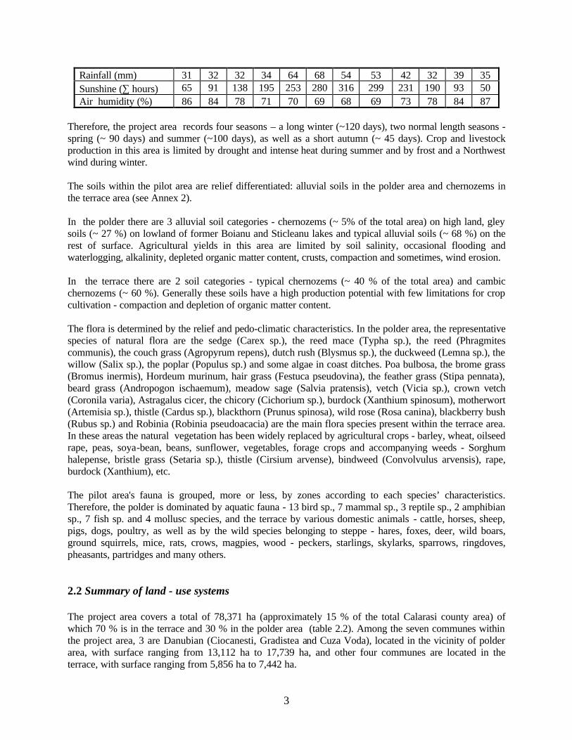
The outcome of this rapid appraisal consists of a geographical description of the pilot area, a summary of land use systems, information on cropping and livestock systems and an evaluation of available data and maps. 2.1 Geographical description The pilot area is situated within the South-Eastern part of Romania, in the Calarasi county and includes the territory of 21 villages in seven communes: Ciocanesti (4), Gradistea (4), Cuza Voda (3), Independenta (3), Alexandru Odobescu (3), Vlad Tepes(2) and Vîlcelele (2). Pilot area's relief is represented by two major areas: polder to the south, near the Danube River and plain to the north , within the terrace of the Danube (see Annex 1). The southern part of pilot area, a former floodplain area that has been drained and transformed into agricultural land in the sixties, is called Boianu - Sticleanu polder and from the administrative point of view, belongs to the Ciocanesti, Gradistea and Cuza Voda communes, as well as to the Dorobantu commune and Calarasi municipality. The landscape is typically flat and uniform with a patchwork of depressions of various size. The land is drained, although this drainage scheme is not well managed and frequently these depressions become waterlogged. At the northeastern extremity of the polder area, there is a large expanse of freshwater, the Iezer Calarasi, providing an important habitat for water birds. The immediate area around the southern part of this water body is grassland. Along the edge of the Danube River there is an area of natural vegetation and wetlands including forests. The landscape is bisected be an extensive network of poorly maintained irrigation and drainage canals and unmetaled farm tracks. Field size is large (> 50 ha), with few physical field boundaries or natural areas of vegetation. There are no villages associated with the polder area and only some farm buildings. The northern part of the pilot area is called terrace area and belongs to the Ciocanesti, Gradistea, Cuza Voda, Independenta, Al.Odobescu, Vlad Tepes and Vilcelele communes. The terrace area has uniform topography being largely flat with sloping lands leading into ephemeral or permanent drainage canals. The southern “tail”of the terrace gently slopes down onto the Danube floodplain. The landscape is dominated by agriculture, land being mainly arable with some grassland areas to support livestock. Field size is variable, with few physical field boundaries creating a landscape that may be considered as “open”. Bisecting this landscape is artificial irrigation and drainage canals (poorly maintained), an irregular network of windbreaks, and a number of small villages. The transport network is well established, although not dense, the major roads being sealed with numerous unmetaled farm tracks. The climate in the project area is of temperate – continental type, with mean multiannual air temperature of 110 C. Multiannual mean rainfall value is about 520 mm of which 67 % falls within the crop growing season (April - October). Also, during this vegetation period the sun shines from 190 to 316 hours/month, and air humidity has values below 80 % (table 2.1). Mean annual wind frequency and velocity values indicate predominant winds from the North and from the West.
Table 2.1 Mean monthly climate parameters Calarasi meteorological station
Parameter/ month I II III IV V VI VII VIII IX X XI XII
Air temperature (C) - 2 1 6 12 17 21 23 22 17 12 7 1
3
Rainfall (mm) 31 32 32 34 64 68 54 53 42 32 39 35 Sunshine (∑ hours) 65 91 138 195 253 280 316 299 231 190 93 50 Air humidity (%) 86 84 78 71 70 69 68 69 73 78 84 87
Therefore, the project area records four seasons – a long winter (~120 days), two normal length seasons - spring (~ 90 days) and summer (~100 days), as well as a short autumn (~ 45 days). Crop and livestock production in this area is limited by drought and intense heat during summer and by frost and a Northwest wind during winter. The soils within the pilot area are relief differentiated: alluvial soils in the polder area and chernozems in the terrace area (see Annex 2). In the polder there are 3 alluvial soil categories - chernozems (~ 5% of the total area) on high land, gley soils (~ 27 %) on lowland of former Boianu and Sticleanu lakes and typical alluvial soils (~ 68 %) on the rest of surface. Agricultural yields in this area are limited by soil salinity, occasional flooding and waterlogging, alkalinity, depleted organic matter content, crusts, compaction and sometimes, wind erosion. In the terrace there are 2 soil categories - typical chernozems (~ 40 % of the total area) and cambic chernozems (~ 60 %). Generally these soils have a high production potential with few limitations for crop cultivation - compaction and depletion of organic matter content. The flora is determined by the relief and pedo-climatic characteristics. In the polder area, the representative species of natural flora are the sedge (Carex sp.), the reed mace (Typha sp.), the reed (Phragmites communis), the couch grass (Agropyrum repens), dutch rush (Blysmus sp.), the duckweed (Lemna sp.), the willow (Salix sp.), the poplar (Populus sp.) and some algae in coast ditches. Poa bulbosa, the brome grass (Bromus inermis), Hordeum murinum, hair grass (Festuca pseudovina), the feather grass (Stipa pennata), beard grass (Andropogon ischaemum), meadow sage (Salvia pratensis), vetch (Vicia sp.), crown vetch (Coronila varia), Astragalus cicer, the chicory (Cichorium sp.), burdock (Xanthium spinosum), motherwort (Artemisia sp.), thistle (Cardus sp.), blackthorn (Prunus spinosa), wild rose (Rosa canina), blackberry bush (Rubus sp.) and Robinia (Robinia pseudoacacia) are the main flora species present within the terrace area. In these areas the natural vegetation has been widely replaced by agricultural crops - barley, wheat, oilseed rape, peas, soya-bean, beans, sunflower, vegetables, forage crops and accompanying weeds - Sorghum halepense, bristle grass (Setaria sp.), thistle (Cirsium arvense), bindweed (Convolvulus arvensis), rape, burdock (Xanthium), etc. The pilot area's fauna is grouped, more or less, by zones according to each species’ characteristics. Therefore, the polder is dominated by aquatic fauna - 13 bird sp., 7 mammal sp., 3 reptile sp., 2 amphibian sp., 7 fish sp. and 4 mollusc species, and the terrace by various domestic animals - cattle, horses, sheep, pigs, dogs, poultry, as well as by the wild species belonging to steppe - hares, foxes, deer, wild boars, ground squirrels, mice, rats, crows, magpies, wood - peckers, starlings, skylarks, sparrows, ringdoves, pheasants, partridges and many others. 2.2 Summary of land - use systems The project area covers a total of 78,371 ha (approximately 15 % of the total Calarasi county area) of which 70 % is in the terrace and 30 % in the polder area (table 2.2). Among the seven communes within the project area, 3 are Danubian (Ciocanesti, Gradistea and Cuza Voda), located in the vicinity of polder area, with surface ranging from 13,112 ha to 17,739 ha, and other four communes are located in the terrace, with surface ranging from 5,856 ha to 7,442 ha.
4
Pilot area land is used mostly for agricultural purposes. The remainder (6 - 17%) is covered by streams and ponds, forest vegetation, buildings and roads. Most of the area is arable. Other land-use categories are insignificant in terms of surface, with the exception of vineyards which cover 1.3 - 2.8% of the agricultural area. The natural pastures and meadows, practically do not exist as surface and generated yields. The area cultivated with perennial and annual forage crops is also very small, compared to the livestock needs. As regarding the land property, there are 3 forms of ownership in the project area – state owned land, located mostly in the polder, public land situated around communes and private land situated on the terrace. The collected field data highlighted the following situation:
- state owned land is covered by field crops (21,449 ha), natural pastures (20 ha), vineyards (21 ha), forests (14 ha), streams and ponds (1,391 ha), roads and buildings (311 ha) and unproductive land (139 ha) . The agricultural land is exploited by 3 state farming companies - CERES Ciocanesti (6,048 ha), AGROSERVCOM Gradistea (4,254 ha) and AGROZOOTEHNICA Mircea Voda (6,055 ha).The forest land is operated by the National Forestry Organisation and fish ponds are operated by Piscicola Calarasi commercial company.
- the public land is covered by natural pastures (366 ha) and roads and is managed by the Local
Council of each commune the private land is, generally arable and it is farmed by agricultural commercial societies, farming associations (either informal or with legal status) and individual landowners. Within each pilot commune there is at least one farming association constituted on the basis of former agricultural co-operative, one company based on a former agricultural mechanisation station, a great number of small family farming associations and many individual farmers. This land is not merged, each farming exploitation having many land plots of different sizes, scattered throughout the territory. Also, the number of landowners is growing due to the division of land among successors.
2.3 Information on cropping and livestock systems This chapter is a synthesis of the information on technological elements of the cropping systems - crop rotation, soil tillage, fertilisers and fertilisation, crop protection, irrigation, yields and livestock systems – species and number, feeding systems, manure management, etc.
5
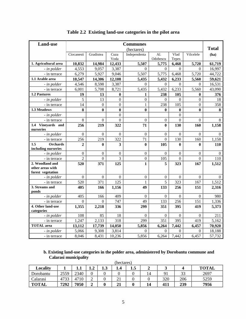
Table 2.2 Existing land-use categories in the pilot area
Land-use Communes (hectares)
Total
Ciocanesti Gradistea Cuza Voda
Independenta Al. Odobescu
Vlad Tepes
Vilcelele (ha)
1. Agricultural area 10,832 14,984 12,433 5,507 5,775 6,468 5,720 61,719 - in polder 4,553 9,057 3,387 0 0 0 0 16,997 - in terrace 6,279 5,927 9,046 5,507 5,775 6,468 5,720 44,722 1.1 Arable area 10,547 14,306 12,108 5,435 5,432 6,233 5,560 59,621 - in polder 4,546 8,598 3,387 0 0 0 0 16,531 - in terrace 6,001 5,708 8,721 5,435 5,432 6,233 5,560 43,090 1.2 Pastures 19 13 0 1 238 105 0 376 - in polder 5 13 0 0 0 0 0 18 - in terrace 14 0 0 1 238 105 0 358 1.3 Meadows 8 0 0 0 0 0 0 8 - in polder 0 0 - in terrace 8 0 0 0 0 0 0 8 1.4 Vineyards and nurseries
256 219 322 71 0 130 160 1,158
- in polder 0 0 0 0 0 0 0 0 - in terrace 256 219 322 71 0 130 160 1,158 1.5 Orchards including nurseries
2 0 3 0 105 0 0 110
- in polder 0 0 0 0 0 0 0 0 - in terrace 2 0 3 0 105 0 0 110 2. Woodland and other areas with forest vegetation
520 371 125 1 5 323 167 1,512
- in polder 0 0 0 0 0 0 0 0 - in terrace 520 371 125 1 5 323 167 1,512 3. Streams and ponds
405 166 1,156 49 133 256 151 2,316
- in polder 405 166 409 0 0 0 0 980 - in terrace 0 0 747 49 133 256 151 1,336 4. Other land-use categories
1,355 2,218 336 299 351 395 419 5,373
- in polder 108 85 18 0 0 0 0 211 - in terrace 1,247 2,133 318 299 351 395 419 5,162 TOTAL area 13,112 17,739 14,050 5,856 6,264 7,442 6,457 70,920 - in polder 5,066 9,308 3,814 0 0 0 0 18,188 - in terrace 8,046 8,431 10,236 5,856 6,264 7,442 6,457 57,732
b. Existing land-use categories in the polder area, administered by Dorobantu commune and Calarasi municipality
(hectares) Locality 1 1.1 1.2 1.3 1.4 1.5 2 3 4 TOTAL
Dorobantu 2559 2340 0 0 0 0 14 91 33 2697 Calarasi 4733 4710 2 0 21 0 0 320 206 5259 TOTAL 7292 7050 2 0 21 0 14 411 239 7956

6
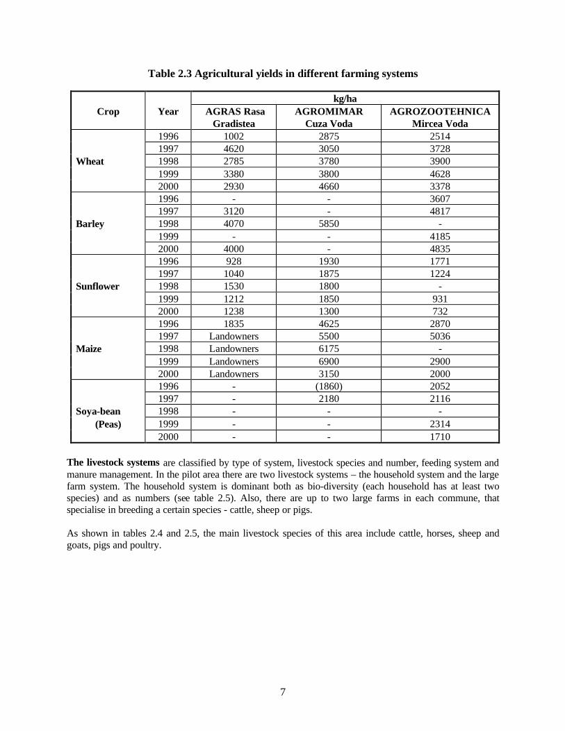
Current crop rotation is different: wheat + barley - wheat + peas (oilseed rape) + sunflower – soya-bean - maize in state companies and wheat - wheat - maize - (maize) - sunflower in individual farms and private companies. Soil tillage is similar for all farming systems – consisting of mouldboard ploughing and disk-harrowing. Crop fertilisation is exclusively chemical, utilizing complex fertilisers (22:22:0) and ammonium nitrate. The fertiliser application rate is 44 - 50 kg P2O5/ha and 110 - 120 kg N/ha. These amounts are applied usually to wheat – prior to sowing, as complex fertilisers and during winter time as ammonium nitrate. Sometimes, sunflower is fertilised too. The crop residue is partly incorporated, partly used as fodder (maize stalks and soya-bean stems ) or as bedding (straw) and most of it is burned. Crop protection includes weed, pest and disease control and it is performed through chemical seed treatment and herbicide application. The chemical weed control is generalised for wheat, barley, soya-bean and sunflower. Weed control for maize is ensured by mechanical and manual methods. The nutrients (N, P) from fertilisers and the heavy metals contained in pesticides are the main diffuse pollution agents. The nutrients can be considered as pollutants when their concentration is very high, especially due to their eutrophic effect. The algae found in coastal ditches are proof to the nutrient diffuse pollution in this area. This phenomenon can be related to the waste management facilities in the area, as well as to local practices of fertiliser application during winter time. As regarding the pollution with heavy metals, there are no available data and the technological information is not clear. Irrigation is only utilized by AGROSERVCOM Gradistea, even though the irrigation scheme covers the entire area. The whole scheme needs rehabilitation. The yields fluctuate both in time and according to each farm type (see table 2.3). Also, as most of the farming information, the yields data of individual farms are not recorded.
7
Table 2.3 Agricultural yields in different farming systems
kg/ha Crop Year AGRAS Rasa
Gradistea AGROMIMAR
Cuza Voda AGROZOOTEHNICA
Mircea Voda 1996 1002 2875 2514 1997 4620 3050 3728
Wheat 1998 2785 3780 3900 1999 3380 3800 4628 2000 2930 4660 3378 1996 - - 3607
1997 3120 - 4817 Barley 1998 4070 5850 -
1999 - - 4185 2000 4000 - 4835 1996 928 1930 1771 1997 1040 1875 1224
Sunflower 1998 1530 1800 - 1999 1212 1850 931 2000 1238 1300 732 1996 1835 4625 2870 1997 Landowners 5500 5036
Maize 1998 Landowners 6175 - 1999 Landowners 6900 2900 2000 Landowners 3150 2000 1996 - (1860) 2052 1997 - 2180 2116
Soya-bean 1998 - - - (Peas) 1999 - - 2314
2000 - - 1710 The livestock systems are classified by type of system, livestock species and number, feeding system and manure management. In the pilot area there are two livestock systems – the household system and the large farm system. The household system is dominant both as bio-diversity (each household has at least two species) and as numbers (see table 2.5). Also, there are up to two large farms in each commune, that specialise in breeding a certain species - cattle, sheep or pigs. As shown in tables 2.4 and 2.5, the main livestock species of this area include cattle, horses, sheep and goats, pigs and poultry.
8
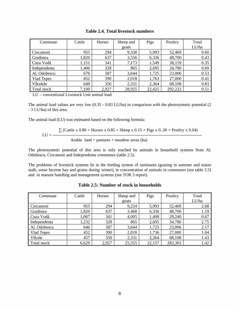
Table 2.4. Total livestock numbers
Commune Cattle Horses Sheep and goats
Pigs Poultry Total LU/ha
Ciocanesti 955 294 9,338 5,993 52,469 0.60 Gradistea 1,820 637 3,556 6,336 48,700 0.43 Cuza Vodã 1,151 341 7,173 1,549 38,159 0.35 Independenta 1,406 328 865 2,695 34,780 0.69 Al. Odobescu 676 587 3,644 1,725 23,006 0.53 Vlad Tepes 452 390 2,018 1,763 27,000 0.41 Vîlcelele 649 350 2,331 2,364 68,108 0.83 Total stock 7,109 2,927 28,925 22,425 292,222 0.51
LU – conventional Livestock Unit animal load The animal load values are very low (0.35 - 0.83 LU/ha) in comparison with the photosyntetic potential (2 - 3 LU/ha) of this area. The animal load (LU) was estimated based on the following formula: ∑ (Cattle x 0.80 + Horses x 0.85 + Sheep x 0.15 + Pigs x 0..30 + Poultry x 0.04)
LU = ---------------------------------------------------------------------------------------------------------- Arable land + pastures + meadow areas (ha)
The photosyntetic potential of this area is only reached by animals in household systems from Al. Odobescu, Ciocanesti and Independenta communes (table 2.5). The problems of livestock systems lie in the feeding system of ruminants (grazing in summer and maize stalk, some lucerne hay and grains during winter), in concentration of animals in communes (see table 2.5) and in manure handling and management systems (see TOR 3 report).
Table 2.5: Number of stock in households
Commune Cattle Horses Sheep and goats
Pigs Poultry Total LU/ha
Ciocanesti 955 294 9,224 5,993 52,469 2.68 Gradistea 1,820 637 3,468 6,336 48,700 1.19 Cuza Vodã 1,067 341 4,005 1,408 29,240 0.67 Independenta 1,232 328 865 2,695 34,780 2.75 Al. Odobescu 646 587 3,644 1,725 23,006 2.17 Vlad Tepes 452 390 2,018 1,736 27,000 1.04 Vîlcele 457 350 2,331 2,264 68,108 1.43 Total stock 6,629 2,927 25,555 22,157 283,303 1.42
9
3. Evaluation of Available data and Maps For this report, we used existing data, available from reports and maps, and especially the primary data collected directly by field observations and interviews with individual farmers and other stakeholders from communes, farming associations and agricultural commercial companies (a questionnaire is attached). The existing land maps were not enough for a comprehensive evaluation. For the state farms associated with the polder area maps are available describing field layout, but using the land suitability maps is not a current practice. 3.1 List of available data and maps Existing data sources have 4 levels: National level: There are many national organisations and institutes that have collected data on the project area: Research Institute for Cereals and Industrial Crops (ICCPT) in Fundulea has a lot of information and experience on environment-friendly agricultural practices – grass based crop rotation, conservation tillage, adequate fertilisation, crop protection, irrigation, windbreaks, etc. Research Institute for Soil Science and Agro-Chemistry (ICPA) in Bucharest maintains and manages a large volume of soil databases. Converting this data into digital databases, stored in a Geographical Information System (GIS), would provide a significant asset to the project. Institute of Studies and Design for Land Reclamation (ISPIF) in Bucharest has undertaken a number of studies on the project area, most notably on the polder area. Two reports, published in the 1990's document in detail the reclamation of the polder and the associated impact of agriculture on the environment, changes to soil and potential for irrigation. Both reports include a number of maps (mainly at 1:100000 scale) which serve as an useful indication of the land suitability of the area. The reports are comprehensive and give an useful description of the environmental conditions of the polder area, its limitations and potential. The Romanian Centre for Remote Sensing Applications in Agriculture (CRUTA) in Bucharest has developed a number of agricultural and climate databases covering Romania under the EC MARS (Monitoring Agriculture with Remote Sensing) programme. The Romanian MARS project was undertaken in the late 1990's and included the whole of Romania. A detailed archive of SPOT and NOAA satellite imagery is held by CRUTA covering this period. CRUTA has also undertaken work funded by WHO (World Health Organisation) to map waste dumps and areas posing a risk to human health including those associated with the Agricultural Pollution Control Project. This data is held on the GIS at CRUTA. Additional digital data may also be available by means of transport networks. The databases are mainly at the scale of 1:100000. County level: Most of these data are available from secondary sources - data on soils, climate and hydrology are held by the County Council and by various organisations in the form of reports, maps, registers, agricultural production statistics, etc. In Calarasi county there are several organisations which are responsible for agricultural and environment – DGAIA, OCAOTA, OJSPA, APM, DSP etc. This means that there are enough secondary data sources for any farming or environmental study. Unfortunately, access to this data is limited. Also, the maps were not available for everybody, not even for the project consultants.
10
Commune level: Mayor’s Offices, churches, schools, rural dispensaries, police offices and their personnel are the most important sources of secondary and primary data.
Our report is based on secondary data collected from Local Councils’ registers, as well as from mayors and other local authority representatives who were able to provide accurate background information. Farm level: Farms represent perennial sources of primary data. Interviews with managers of agricultural commercial companies, with leaders of farming associations and with individual farmers (see annex 5) were thus very useful, providing the means to understand the problems of cropping and livestock breeding. Also, the existing data were completed and amended through many direct field observations of sites, commune households and farming systems. 3.2 Results of field verification Data collected from secondary sources were generally confirmed by field verification. However, the existing land-use information are quite different from the field data, especially those referring to pastures, meadows, woodland and wetland areas. The polder area, formerly part of the Danube floodplain, is a fragile agricultural habitat that is particularly important for water birds. This area, having been reclaimed was intensively exploited for crop production although livestock breeding enterprises on the three former state farms were also significant in terms of productivity and unfortunately also as impact on the environment Over the last decade (post-1989) there has been a general decline in the intensity of management of this area largely due to financial constraints rather than lack of know-how (although it is important to note that strategically the focus was on, and still is, production rather than a more balanced approach that takes into account the environmental issues associated with this habitat). Consequently, much of the pollution (nitrates, phosphates and pesticides) associated with the polder is historic in nature, and despite the preponderance of area down to arable land pollution levels are likely to be generally low. The vegetation bordering the canals along the urban fringe with the polder area (e.g., Gradistea) are indicative of high levels of eutrophication and this was confirmed in many places by the high levels of algae in these canals. It is likely though that much of the pollution causing these problems is associated with the gardens of properties that back right onto the canals. In the majority of these gardens it was observed that maize stalks, straw and animal waste is deposited along the banks of the canal. Run-off high in nitrates and other pollutants into the canal is likely to be high and be significant contribution to the pollution of these waterways rather than agricultural activities per se. There was no evidence of soil erosion from water, although wind erosion may be a localised problem in some areas. There is a concern that with the decline in the irrigation and drainage network that waterlogging is occurring in places and that the soil is becoming more saline (and alkaline) in nature. This will affect yields. Indeed, on the AGROSERVCOM farming company over 150 ha of cereals had been lost due to waterlogging (equivalent to $30 000/year). The state farms on the polder area will be privatised. There is concern that following privatisation there will be greater access to credit or funds to rehabilitate the irrigation and drainage network and purchase non-farm resources such as pesticides and inorganic fertilisers leading to a more intensive form of agricultural production. Many of the current farm managers of these farms also expressed a desire to start livestock farming as well (on two of the state farms about 400 sheep are managed). These investments and access to non-farm resources should result in greater productivity however, these foreseen changes will also pose a considerable risk to the environment.
11
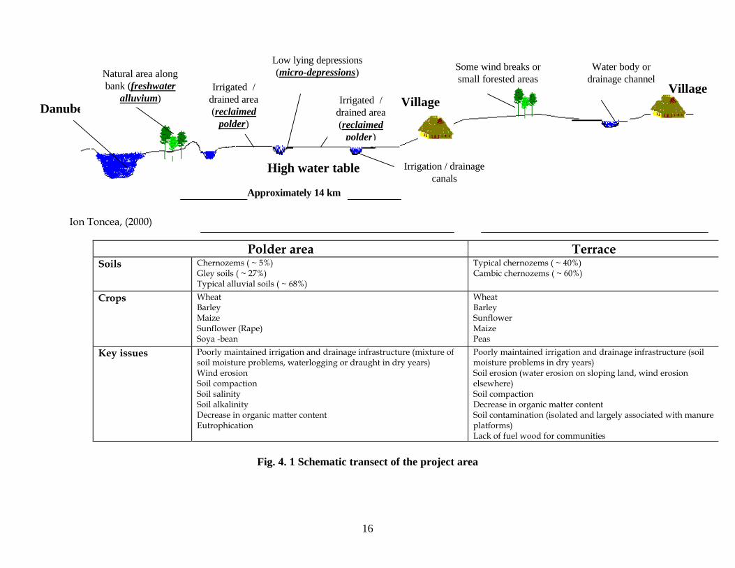
There is now an opportunity to influence the development of the polder area and the type of agricultural practices. Consideration should be given in identifying areas on the polder that can revert to wetlands or extensive grassland to encourage water birds. The application and timing of inorganic and organic fertiliser will require careful management to minimise the loss of nitrate to surface and ground waters. The introduction of agroforestry and shelter-belts will reduce the risk of wind erosion and will encourage bio-diversity. The land use of the terrace area is almost entirely agricultural, with the exception of some large water bodies and village areas. The agriculture practised here is generally intensive in as much that it is largely mechanised (although the machinery is small relative to field size) and agro-chemical based. The farms associated with the terrace are under capitalised and consequently the inputs in terms of pesticides and fertilisers are relatively low. Agricultural pollution associated with the terrace area is mainly historical and attributed to practices pre-revolution (pre-1990's). Current doses of pesticides are low and fertiliser use conservative. Soil erosion appears to minimal, wind erosion apparent in some of the large fields where there are no or poorly maintained shelter belts. Water erosion occurs on some of the gentle slopes associated with the riparian zones although this is not wide spread. The rates of soil erosion do not appear to be greater than the accepted natural rate of 11 t/ha. Other important issues related to hazards to the environment (latrines pollution, pollution from urban domestic waste and pollution from drainage canals situated in the polder) are not addressed by this project. There appears to be a shortage of fuel wood in the local vicinity and consequently people have to travel considerable distance to get it, frequently relying on crop residues as an alternative. There is considerable scope to develop community wood lots to supplement the source of fuel wood and timber and the land around villages appears quite suitable for this. Fast growing species such as Robinia, poplar and willow would be appropriate. 4. Description of Land Use Suitability supported with map(s) This chapter deals with the limitations to agricultural productivity, identifies the main land units of the project area and assesses the suitability of the land to the major crops currently grown. Recommendations are given to the management of the land and possible changes in land use to meet the wider objectives of the project. 4.1 Narrative The polder and terrace areas distinguish the land units of the project area and each of them has 3 minor landforms (see fig. 4.1). The land elements of polder area are freshwater alluvium, reclaimed polder and micro-depressions. Freshwater alluvium Although not included within the project area, this is an important element related to Danube water protection and polder bio-diversity conservation. This “strip” of land extends along the northern embankment of the Danube and is a remnant of the former floodplain. The strip of land is effectively a buffer between the reclaimed polder area and Danube river. The vegetation associated with this area is a mixture of wetland grasses, reed beds and trees (e.g., various willows). The alluvial soils have various textures and undergo different stages of siltation and waterlogging.
12
This area is a natural habitat providing an important haven for wildlife and in particular for water birds. The area also acts as an important buffer towards the agricultural area, acting as a biological filter trapping silts, toxic compounds and diffuse pollutants. The area could be more actively managed to improve the bio-diversity of the surrounding zone i.e., where it borders the reclaimed polder (e.g., establishment of wildlife corridors into the polder area) and may also benefit from the development of agro-tourism. Reclaimed polder A reclaimed floodplain bordering the Danube, this substantial agricultural area is characterised by a range of alluvial soils including chernozems, mollic alluvial soils and alluvial protosoils with large areas which are either waterlogged and/or salinized Irrigation and drainage is widely practised in this area, although during the last decade the overall management of this infrastructure has declined significantly. The productivity of this area is mixed and highly dependent on appropriate irrigation and drainage practices. According to the ISPIF reports about 60% of the land in the polder area is considered as suitable for irrigation, and only 26% as good or very good for irrigation. The crops grown (typically wheat, barley, maize, sunflower and soya-bean) give low to medium yields, receiving low inputs of inorganic fertilisers and pesticides. The scope to improve yields is significant but it is important that this is not at the expense of the environment. The increase in the area affected by alkalinity is a concern as is the threat of salinity. Nutrient management for the area will be critical to minimise diffuse pollution. Nitrate levels associated with the polder are recorded as low. Practices in the past have not been conducive to low nitrate levels (e.g. irrigation using waste-water from livestock enterprises and poor manure management on the terrace area giving rise to run-off onto the polder). Micro-depressions These are lower lying areas or depressions that are commonly waterlogged.These would generally have been wetland areas or small lakes and the soils of these features are of a low productivity and difficult to manage. Given the current decline in irrigation and drainage capital, these areas would be more suitable for agroforestry (e.g. willow plantations), for extensive grass production (for grazing purposes) or to be reverted to a natural habitat (mixture of reeds and grasses). Wildlife corridors could be established from Calarasi lake to the freshwater alluvial area to encourage bio-diversity and generally enrich the habitat. Terrace area has, also, three minor elements – agricultural terrace, village area and riparian zone. Agricultural terrace Agriculture is the dominant land-use of the terrace area that includes largely uniform and fertile soils, typically chernozems and cambic chernozems. Crop productivity is low to medium, the main hindrance being soil moisture particularly in dry years, and lack of inorganic fertilisers and pesticides. Concern at the decline in soil fertility has been expressed greater use of organic fertilisers and the introduction of soil moisture conservation practices (these will be addressed by the project), which could stop this trend. Village area The intravillage environment is affected by household and farm waste, as well as by village or commune waste platforms. The wastes arising from the households are: urine and manure from animals, maize stalk, straw and other crop residues, inert materials (plastic, glass, metal and cardboard), as well as latrine waste (the last is not addressed in our project). The waste generated by large former state farms (slurry and solid waste), is no longer a problem because of the current low number of animals.
13
The waste platforms are the major source of pollution with livestock waste, both as direct pollution by run- off to water courses and diffuse pollution by leaching into the watertable. These platforms will continue to pose a threat to the environment unless the waste is removed and recycled. In some areas, particularly in close proximity to communes, the establishment of agroforestry practices or reforestation with the purpose of ensuring fuel wood reserves for the community, may be considered as a more suitable land-use. Riparian zone This area is associated with the water bodies and ephemeral drainage networks of the terrace area. It may be prone to water erosion since it is associated with sloping land and will also be potential hot-spot for diffuse sources of agricultural pollution such as run-off carrying sediments, nitrates or pesticides. The banks of canals are also prone to collapse in places, particularly where cultivation is taking place right up to the edge of these banks. For sloping land associated with natural drainage networks, agricultural practices are acceptable as long as measures are taken to minimise the risk from water erosion (e.g., cultivation across the slope). Buffer strips, particularly at the foot of slopes, would minimise the sedimentation of water courses and act as a filter thereby improving water quality. 4.2 Land use suitability map(s) at 1:10 000 The development of a detailed land suitability assessment within the scope of this report is not feasible due to the lack of readily available information. Nonetheless, based on the indicative land units described above, an indication of the land suitability for the predominant crops grown in the project area is given in table 4.1. Crucially, for the polder area, agricultural productivity and land suitability will depend on the viability of the irrigation and drainage infrastructure, and the careful management of waters and soil. Whilst irrigation and drainage are not so significant for the terrace area (although they would certainly improve yields during dry seasons), the conservation of soil fertility will be crucial. Alternative crops are not discussed in this report, although the land is suitable for growing vegetables, root crops such as sugar beet, and sorghum. However, a more detailed study into the economic viability of establishing these crops would be required, being outside the scope of this report. Livestock production is not as significant as historically (pre-revolution). A more mixed farming system could play an important role in the management of the project environment via the recycling of organic manure and the use of rotational grasslands to improve soil structure and maintain or increase organic matter. In the polder area the introduction of extensively managed grassland breaks in the rotation could contribute to minimising the amount of nitrogen leached. The use of cover crops during the autumn, such as mustard, may also reduce the amount of nitrate leached. Livestock production is suitable for the polder area but the associated manure management will be critical to ensure that the loss of nitrate to the environment is minimised.
Table 4.1 Suitable crops for project area
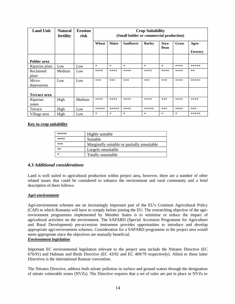
14
Land Unit
Natural fertility
Erosion risk
Crop Suitability (Small holder or commercial production)
Wheat Maize Sunflower Barley Soya- Bean
Grass
Agro- Forestry
Polder area
Riparian plain Low Low * * * * * **** ***** Reclaimed plain
Medium Low **** **** **** **** **** **** **
Micro-depressions
Low Low *** *** *** *** *** **** *****
Terrace area
Riparian zones
High Medium **** **** **** **** *** **** ****
Terrace High Low ***** ***** **** ***** *** **** *** Village area High Low * * * * * * *****
Key to crop suitability
***** Highly suitable **** Suitable *** Marginally suitable or partially unsuitable ** Largely unsuitable * Totally unsuitable
4.3 Additional considerations Land is well suited to agricultural production within project area, however, there are a number of other related issues that could be considered to enhance the environment and rural community and a brief description of them follows: Agri-environment Agri-environment schemes are an increasingly important part of the EU's Common Agricultural Policy (CAP) to which Romania will have to comply before joining the EU. The overarching objective of the agri-environment programmes implemented by Member States is to minimise or reduce the impact of agricultural activities on the environment. The SAPARD (Special Accession Programme for Agriculture and Rural Development) pre-accession instrument provides opportunities to introduce and develop appropriate agri-environment schemes. Consideration for a SAPARD programme in the project area would seem appropriate since the objectives are mutually beneficial. Environment legislation Important EC environmental legislation relevant to the project area include the Nitrates Directive (EC 676/91) and Habitats and Birds Directive (EC 43/92 and EC 409/79 respectively). Allied to these latter Directives is the international Ramsar convention. The Nitrates Directive, address both nitrate pollution in surface and ground waters through the designation of nitrate vulnerable zones (NVZs). The Directive requires that a set of rules are put in place in NVZs to
15
reduce existing nitrate pollution from agricultural land and to prevent further pollution from arising. The rules are known as Action Programme rules or measures. Compliance with the rules is a legal requirement within those areas designated by each government as NVZs. The Romanian Government Decision nr. 964/13.10.2000 concerning an Action Plan for Water Protection Against Nitrates Pollution from Agricultural Sources promote the same international rules, aiming to reduce existing nitrate pollution from agricultural land and to prevent further pollution. The Birds Directive seeks to conserve all species of naturally occurring birds in the wild state in the European territory of the Member States. Whilst the Habitats Directive seeks to contribute towards ensuring bio-diversity through the conservation of natural habitats and wild flora and fauna in the EU, the Ramsar convention addresses the stemming of loss of wetlands and ensuring their conservation and wise use. Iezer Calarasi is an important habitat for water birds. The Iezer Calarasi wetland stretches for about 3,200 ha and the waterbody itself for approx. 400 ha, being an important migratory passage. There is a risk that increasing agricultural activities in the area will threaten this important habitat and therefore the site has been put forward to be gazetted as a protected area by the government, the 400 ha forming the core area and the remainder making up a buffer zone. A detailed management plan will be required to ensure that the objectives of the proposed protected area are fully met. Consideration must be given to getting the co-operation of local farmers and farms in the implementation of the management plan and cross compliance with other agri-environment measures and programmes should be fully explored and developed to ensure maximum benefit. Fuel wood Fuel wood is an important supplement to heating during the winter months for the village population. There appears to be a shortage of fuel wood in the local vicinity and consequently people have to travel considerable distance to get it, frequently relying on crop residues as an alternative. There is considerable scope to develop community wood lots to supplement the source of fuel wood and the land around villages appears quite suitable for this. Fast growing species such as Robinia, poplar and willow would be appropriate.
16
Ion Toncea, (2000)
Polder area Terrace Soils
Chernozems ( ~ 5%) Gley soils ( ~ 27%) Typical alluvial soils ( ~ 68%)
Typical chernozems ( ~ 40%) Cambic chernozems ( ~ 60%)
Crops
Wheat Barley Maize Sunflower (Rape) Soya -bean
Wheat Barley Sunflower Maize Peas
Key issues
Poorly maintained irrigation and drainage infrastructure (mixture of soil moisture problems, waterlogging or draught in dry years) Wind erosion Soil compaction Soil salinity Soil alkalinity Decrease in organic matter content Eutrophication
Poorly maintained irrigation and drainage infrastructure (soil moisture problems in dry years) Soil erosion (water erosion on sloping land, wind erosion elsewhere) Soil compaction Decrease in organic matter content Soil contamination (isolated and largely associated with manure platforms) Lack of fuel wood for communities
Fig. 4. 1 Schematic transect of the project area
Some wind breaks or small forested areas
Danube
Natural area along bank (freshwater
alluvium) Irrigated /
drained area (reclaimed
polder)
High water table
Village
Approximately 14 km
Village
Water body or drainage channel
Low lying depressions (micro-depressions)
Irrigated / drained area (reclaimed
polder)
Irrigation / drainage canals
17
5. Recommendations for trial and demonstration of environment-friendly agricultural practices Practices were selected that can be applied by farmers using inexpensive material and labour. The environmental effects for all recommended practices are beneficial, but quantifying these effects will require long-term monitoring of the ground and surface water within the project area. The overriding natural resource concern that prompted development of this project is pollution of the Danube river and Black Sea from water leaving Romania through groundwater lateral flow and run-off into tributaries. Addressing this primary concern will provide spin-off effects that will benefit other natural resources and social concerns identified by stakeholders during our field review. Those expressed concerns are:
∗ Pollution of water caused by leakage of pollutants into the water system; ∗ Unsuitable drinking water and associated diseases throughout much of the project area; ∗ Moisture conservation on cropland; ∗ Declining soil tilth; ∗ Inadequate forage for current and planned increases in livestock production; ∗ Lack of community pride and economic stability; ∗ Uninformed community members concerning environment - friendly agricultural technologies.
In meetings with the farmers within the communes, it was notable that they expressed full support and gave first priority to waste management, land-use improvement and sustainability of the cropping and livestock systems within the project area. 5.1 Evaluation of existing practices and constraints to adoption of improved practices Existing practices are almost exclusively crop production oriented with very little consideration for higher technology related to public benefits. Practices currently being applied are cultural practices characteristic of farmers who keep themselves informed concerning agronomic principles, but lack financial resources to invest in environment-friendly practices that have mutual public benefits. These practices include:
1. Crop Rotation - consisting of cereals and industrial crops traditionally cultivated in the local area. They are grown in various rotations to break disease cycles, and for other traditional and economic reasons. Very few farmers manage a grass based rotation. Research Institute for Cereals and Industrial Crops located at Fundulea reports a favourable yield response from grass based crop rotations and with fewer agricultural inputs. This would be a very beneficial practice. In most areas of the project no particular objections to high level crop rotations was expressed and due to current interest in increasing livestock, there appears to be potential for increasing forage crops including grasses for inclusion in crop rotations.
2. Soil Tillage - is applied with the traditional mouldboard plough and heavy disk-harrow during the summer or autumn. The soils apparently receive intensive tillage for weed control and seedbed preparation. This is generally considered sustainable for deep soils. However, there is clear evidence that soil tilth needs improvement. The only way to significantly increase soil organic matter and subsequently improve soil tilth is to perform tillage operations designed and timed to leave crop residue on or near the soil surface consistently for many years. A long term objective for agriculture in Romania should be the elimination of the mouldboard plough. Excessive tillage, particularly mouldboard ploughing, causes rapid loss of organic material needed for humus formation and accumulation. There are few constraints to immediate adoption of conservation tillage. However, the many of the farmers are familiar with the practice, but do not believe it is feasible under current
18
economic conditions. If funds are made available to provide tillage tools for a proper long-term demonstration of reduced tillage, a gradual increase in utilization of this practice should occur over a ten to twenty year time period. This would represent the normal adoption period of new agricultural technology. 3. Fertilisation - is exclusively chemical: the chemical nutrients are applied usually before sowing as complex fertilisers and during winter or spring time as urea or ammonium nitrate. The main constraint to increase the efficiency of nutrients is the lack of a Crop Nutrient Management Plan, to include all nutrient sources – manure, crop residues, fertilisers, previous crops, irrigation etc. and specific nutrient management practices: manure application tests and variable rate application techniques.
4. Weed and Pest Management - involves the use of chemically treated seed, herbicides and using mechanical and manual means. The low efficiency of these practices is due to the lack of weed and pest management strategies.
5. Irrigation is the key to the success of farming systems in this area. However, the existing irrigation systems need substantial investments in rehabilitation, and such efforts should be correlated with the public awareness programme.
5.2 Recommended practices by sub-zone There are many environment-friendly practices used on cropland in various locations to help solve natural resource problems. The practices included in this section of the report were selected for the following reasons:
• No adverse environmental effects; • Cost effectiveness/low-input; • Easy installation using farm labour and local materials; • Technology is readily transferable; • Aesthetic appeal;. • Acceptable to the farmers; • Positive social effects; • Effective as a stand-alone practice if necessary; • Low or no secondary side effects.
With the exception of conservation tillage, practices that are expensive to install and maintain were not deemed candidate practices for this project: This portion of the report will discuss the list of candidate practices :
1. Conservation Tillage is any tillage system that leaves about 1/3 of the soil covered after the crop is planted. To accomplish this objective only very limited tillage can be performed as follows: – inverting to 15 cm depth and loosening to 30 cm depth, noninverting, loosening to 30 cm depth. Several crop residue management techniques are also necessary to apply this practice. Straw spreaders must be attached to the combines or any accumulations of straw must be evenly distributed to allow proper operation of the planter. Conventional maize planters can often be converted for conservation tillage by installing coulters (disk blades) that run ahead of the seed placement part of the planter. The more sophisticated planters plant the seed, apply starter fertiliser and pesticides in one operation. 2. Narrow Vegetative Barriers are rows of stiff-upright-tall grass (about 1 metre wide) that provide benefits similar to windbreaks. They are very easy and inexpensive to install and become effective within the first year. They may be installed on the contour to help control small gullies, and reduce sheet and rill erosion. They may also be used in conjunction with other practices such as filter strips to
19
prevent excessive amounts of sediments from entering the filter strip area. In this project, their primary purpose would be to trap winter snow for moisture management purposes. 3. Crop Rotation is following a planned rotation of crops designed to improve soil quality, break pest cycles, and satisfy other crop production requirements. 4. Grasses and Vegetables in Rotation represents a crop rotation that includes grasses and/or vegetables in the rotation for the purpose of increasing organic matter content, breaking pest cycles and satisfying other crop production requirements. 5. Crop Nutrient Management is utilizing available plant nutrients by developing and following a nutrient budget designed to prescribe correct field applications. 6. Weed and Pest Management is using pesticides only when necessary, after careful consideration of more environmentally acceptable alternatives for pest control. 7. Filter Strips are strips of perennial grass established along the lower portion of a field to filter out potential pollutants. 8. Land Reclamation is induced by the need to reduce pollution from water run-off and deep percolation of polluted water. The land should be cleaned of waste, shaped and vegetated to restore aesthetics, provide fuel wood, grazing, wildlife food and cover, and possibly recreation areas for the public benefit. 9. Wellhead Protection is designing and installing structures to reduce the risk of pollutants entering the water system at or near the wellhead. The structures, for this project, would generally consist of a concrete or asphalt apron that prevents water accumulation around the wellhead. 10. Grazing Management - demonstrates how rotation grazing can improve land fertility and productivity.
All these are designed to function as stand-alone practices but field application has proven the benefits of applying systems of practices that benefit each other in synergistic ways. The selected environment-friendly agricultural practices are acceptable to most of the farmers in the project area: Polder area Conservation Tillage - soil and mulch tillage; Crop Rotation; Crop Nutrient Management;
Weed and Pest Management; Narrow Vegetative Barriers; Filter strips - for micro-depressions areas; Grazing Management; Terrace area Conservation Tillage - soil and mulch tillage Crop Rotation Crop Nutrient Management

20
Weed and Pest Management Narrow Vegetative Barriers Manure Management Grazing Management Village area
Organic Gardening - Crop Rotation & Nutrient and Pest Management Land Reclamation
Wellhead Protection 5.3 Criteria for the selection of sites for Testing and Demonstrating programme The sites selected for testing and demonstrating (T/D) the practices were chosen for the following reasons: • Site adaptation to each specific practice - Each practice has specific soil and site requirements for
proper testing and demonstration. However, most of the practices chosen for demonstration are adapted to almost any location within the project area. Site selection was therefore, based more on geographic and strategic locations rather than soil and site characteristics.
• Enthusiasm expressed by commune representatives - It is imperative that practices are located on sites
where stakeholders are ready, willing, and able to apply and manage the conservation practices. The field trips indicated a lot of enthusiasm towards testing and demonstrating these practices.
• Technical abilities of the stakeholders - Most of the practices will require training to ensure they are
planned, applied, and managed so that project objectives are met. As practices range from low-tech to very high-tech, care must be taken to make sure the proper people are selected to apply and manage the practices.
• Logistics for public display and monitoring activities - It is important to locate the practices where
people can see them and visit the sites efficiently. It is also advantageous to locate many of the sites in a central location to improve efficiency during the monitoring phase of the project.
5.4 First year programme The following are the first year (2001) practice recommendations, eligible for selection. Each individual practice proposal will require a detailed plan of work prepared by participants, specifying each individual necessary task, the person(s) responsible and the deadline for successful completion of each step.
1. Crop rotation - a suitable crop rotation will be provided. This practice will be installed during the summer and autumn of 2001 in both polder and terrace areas. The crop rotation should be established to the adapted field crops, including annual crops and perennial grass. 2. Manure management – will provide the farms and communes with a waste management plan for reducing the risk of water and land pollution from manure handling, storing and land spreading systems. A waste composting training course and specialized assistance will be required.
3. Crop nutrient management – will increase nutrient efficiency to maximize economic return while preserving or improving environment conditions. To increase nutrient efficiency, farmers must apply plant nutrients at the right time and place in order to achieve the forecasted yield. This approach will help reduce potential pollution of surface and ground water within the whole project area.
21
4. Weed and Pest management – will involve the use of various management practices that either prevent or reduce economically harmful weeds, insects, disease and other pest population. Specific practices will include scouting fields, rotating crops, planting resistant crops, encouraging beneficial insects and, when necessary, using crop protection products – herbicides, insecticides and fungicides.
5. Narrow Vegetative Barriers - will demonstrate how grass strips can trap snow and increase available moisture between the strips. The strips should be established to an adapted tall growing species. This will be established during autumn 2001, within fields with existing windbreaks and drainage canals as part of the total system including conservation tillage, crop rotation & nutrient and pest management. Narrow vegetative barriers will provide a good comparison between different farming practices, being a decision tool for project area farmers who would observe performance of such practices. It will also enhance credibility of yield data collected by the farmers.
Training of 180 farm managers within project area is also part of the first year programme. Also, up to ten participants can be identified for a U.S study tour hosted by USDA or a university located within the “corn belt” area of the United States. 5.5 Indicative 2 – 5 year programme
1. Conservation Tillage - will provide the best alternative to conventional soil tillage by utilizing implements like cizel or paraplough and a high tech tillage(planters plant the seed, applying starter fertiliser and pesticides in one operation), or tillage attachments to make existing planters suitable for minimum tillage.
2. Mulch Tillage - high residue drill necessary for drilling of the field crops residue. This tillage system usually includes straw spreaders. Also, any accumulations of straw must be evenly distributed to allow proper operation of the planter.
3. Filter Strips - will improve agricultural quality of the polder land by slowing water run-off from the micro-depressions, as well as the water quality through the filtering action of grass or other vegetation, also allowing increased time for decomposition, denitrification and other chemical processes that cleanse the water intercepted by the strips of vegetation.
4. Land Reclamation - will be demonstrated on the existing manure platform areas. Land reclamation is needed to reduce pollution from water run-off and deep percolation of contaminated water. The land should be cleaned of waste, shaped and vegetated to restore aesthetics, provide fuel wood, grazing, wildlife food and cover, and possibly recreation areas for the public benefit.
5. Wellhead Protection is needed for many wells in the 7 communes. An inventory of these wells will be conducted by the local people and unprotected wellheads will be improved through concrete structures (aprons) meant to drain water away; also as a protection measure, vegetation will be planted around public and private wells. The project will provide the necessary materials and local communities will commit themselves to install the improvements.
6. Organic Gardening will be developed in the village area as an alternative to traditional gardening. The householders will discover the satisfaction of recycling their domestic waste, of choosing from a wide range of quality vegetables, medicinal and aromatic plants and ornamental flowers, or of eating fresh fruits, grapes, etc. 7. Grazing Management - will demonstrate how a grazing plan can improve grass and livestock yields. It should be implemented within village grazing areas, to reduce the soil erosion too.

22
Practice application schedules will need to be reaffirmed following site planning activities with local farmers and community leaders. 5.6 Performance indicators to evaluate impact on agricultural productivity and the environment Measuring the environmental impacts of agronomic practices requires a long term evaluation. Impacts that occur beneath the soil surface are insidious and require very precise data collection. The practices included in the total system will have positive benefits, possible to be monitored through a multitude of performance indicators. Soil improvement will be significant within 5 years. Crop yields can be documented as soon as the vegetative strips are effective. Wildlife food and cover will increase significantly and a more diverse fauna inventory should be documentable within a few years. Earthworms and other soil organisms are depleted and any change in soil quality will be felt on them. Any run-off water will be significantly cleaner, and groundwater quality may improve if it is currently polluted. 5.6.1 Indicators for Soil Quality Evaluation The soil quality indicators are important to guide land-use decisions, evaluate the effects of the agricultural practices and to focus conservation efforts on maintaining and improving the soil quality. Indicators of soil quality can be categorized into four general groups: visual, physical, chemical and biological parameters.
Visual indicators may be obtained from observation or from photographic interpretation. Exposure of subsoil, topsoil and subsoil colour, ephemeral gullies, ponds, run-off, plant response, weed species, soil blowing and depositing are the main locally determined indicators. Physical indicators are related to the arrangement of solid particles and pores. Examples include topsoil depth, bulk density, porosity, aggregate stability, texture, crusting, cracking and compaction. Physical indicators primarily reflect limitations to root growth, seedling emergence, infiltration or movement of water within the soil profile.
Chemical indicators include measurement of pH, salinity, organic matter content, phosphorus concentrations, cation-exchange capacity, nutrient cycles and concentration of elements that may be potential contaminants (heavy metals, radioactive compounds, etc.) of those that are needed for plant growth and development. The soil's chemical condition affects soil-plant relations, water quality, buffering capacity, availability of nutrients and water to plants and other organisms, mobility of contaminants and some physical conditions, such as the tendency to form a crust.
Biological indicators include measurement of micro- and macro-organisms, monitoring their diversity and activity. Earthworm or nematode populations have been suggested for use in some parts of the project area. Respiration rate can be used to detect germs’ activity, specifically organic matter decomposition in the soil. Ergosterol, a fungal bio-product, has been used to measure the activity of organisms that play an important role in the formation and stability of soil aggregates. Measurement of decomposition rate of plant residue in bags or measurement of weed seed numbers, or counting pathogen populations can also serve as biological indicators of soil quality.
5.6.2 Indicators for Farming Systems’ Productivity Evaluation The main indicators of the productivity of farming systems are yields, resource efficiency and farm income. Important to farmers, also, are the soil cover rate, crop growth rate and monitoring of key farming activities – crop rotation and management of waste, crop nutrients, water, weeds and pests.
23
5.6.3 Indicators for water quality evaluation Standardized water quality indicators are needed to provide reliable data on problems and trends in water quality of the Danube river, its tributaries and the Black Sea. The water quality monitoring programme should include the monitoring of various specific parameters:
- pH, turbidity, odour, suspended solids, electric conductivity; - nitrates (NO3), ortho and total phosphorus (P), calcium (Ca), magnesium (Mg), sodium (Na),
carbonates (CO3), sulphates (SO4), and pesticide content; - faecal coliform bacteria and streptococus bacteria infestation; - algae incidence in canals.
6. Recommendations for trial and demonstration of agro-forestry practices
Agro-forestry is a distinct land-use system, which may include combinations of tree production with other crops and/or animals on the same land at the same time, with the main objectives of reducing risk and increasing total productivity as a result of efficient use of sunlight, moisture and plant nutrients. In-between rows of trees, food crops, forage crops, vineyards, fruits and a number of special crops may be grown and harvested or grazed by the domestic animals. This is a relatively new concept that is becoming accepted as a cost-effective way to produce income from land partially devoted to tree production. During field trips, the farmers expressed interest in planting windbreaks, and using other agro-forestry technologies to improve the environment in the project area. They expressed concern for:
∗ Deforestation and subsequent effects; ∗ Global warming; ∗ Localized wind and water erosion; ∗ Lack of fish and wildlife food and cover;
∗ Lack of recreational opportunities for community members; 6.1 Evaluation of existing practices and constraints to adoption of improved practices Agro-forestry existing practices include: tree planting in the polder area, windbreaks in the terrace agricultural area and home gardens in the village area.
1. The tree planting is a successfully partial integration of crop and tree husbandry aimed to enhance soil fertility and to restore natural plant cover, replenishing fuel wood and timber resources. In-between trees of recent plantations, food crops are allowed to be cultivated for 4 – 5 years while the trees are still young. After this 4 to 5 year cropping period, the trees are managed as a monoculture forestry unit. The existing tree plantations have been developed with institutional intervention along the Danube embankment. The vegetation associated with this area is a mixture of wetland grasses and willow trees. High costs and lack of saplings supply are the main constraints to tree planting.
2. The tree windbreaks are used to protect soils and modify the microclimate associated with crops, orchards, livestock housing facilities, human settlements and roads. The existing tree windbreaks are located in Cuza Voda and Marculesti communes but are currently almost cleared. They represent a remainder of a project which has been developed in the sixties throughout the whole terrace area, with institutional intervention. A new windbreak is installed at the Research Institute for Cereals and Industrial Crops-Fundulea, for research purposes. In spite of existing community level experience and interest in windbreaks, this is not a widely used practice due to present economic conditions and confusing forestry and land ownership legislation.
24
3. Home gardens refers to an agro-forestry system which has been traditionally developed and adopted by the village inhabitants without any institutional intervention. It is characterized by intensive use of multipurpose tree species, shrubs, food and fodder crops and animals on the same piece of land at the same time. In a home garden, the rear side of the garden is often constituted of trees & shrubs species that produce fuel wood, fruits, fodder, flowers and shade. The middle section may produce grapes and vegetables. The front side of such garden is the place for buildings (house, livestock stables, ancillary structures) and for the medicinal and ornamental plants. Often overlooked values of home gardens are such amenities as reduced wind forces, shade, privacy screening and landscape aesthetic. Improving home garden systems assumes the introduction of new tree or crop species, as well as intensifying cropping patterns. The existing agro-forestry practices are limited by:
- the lack of quantitative data which prevent a rigorous cost-benefit analysis. Therefore, adopting
and implementing agro-forestry systems is something of a gamble, particularly when a long-term tree plantation component is involved;
- incomplete investment cost recovery, because some agro-forestry benefits (e.g. extension of
wildlife habitats; improved living standards for the community, etc.) are not marketable; 6.2 Recommended practices by sub-zone Most of the stakeholders in the project area expressed interest in tree planting and in using buffer technologies to improve environment conditions, as these practices are effective even when installed as a stand-alone component, enabling application by the farmers with labour and tools readily available; they do not have adverse environmental effects, generate social benefits and are pleasing to the eye and functional. Therefore, several agro-forestry practices can be implemented during the term of the project:
1. Hedge rows are shrubs planted along field or plot edges (usually a single row) to provide environmental benefits such as soil protection from wind erosion, crop protection from wind damage, snow drifting control, soil moisture conservation, favourable habitat for beneficial insects and food and cover for wildlife.
2. Tree planting is combining fuel wood, timber and fruit trees production with other crops on the
same land at the same time. In-between rows of trees, annual field crops, forage crops, vegetables and other special crops may be grown and harvested.
3. Windbreaks are rows of trees and shrubs planted for the purpose of reducing wind force,
protecting crops from desiccating winds, providing food and cover for wildlife and recently, for animal feeding. They are usually 5 to 50 metres wide, with 2 – 4 metres spacing between rows.
4. Riparian buffers are streamside plantings of trees, shrubs and grasses that can intercept pollutants
from both surface and shallow groundwater before they reach a river or stream. Riparian buffers stabilise lake and river banks and provide favourable habitat for wildlife (e.g., enhancing fish habitat by, among other things, reducing water temperature).
5. Shelterbelts are rows of shrubs (usually two or three rows) planted for the purpose of protecting
gardens, livestock and farm structures from harsh weather and to provide fencing of tree plantations and grazing areas.
The following specific agro-forestry practices are recommended according to each individual project zone:
25
Polder area Hedge rows - for reducing wind erosion; Tree planting – for land-use suitability;
Riparian buffers - for protecting Iezer Calarasi, an important habitat for water birds. Agricultural terrace area
Hedge rows – for protecting crops and wildlife habitat; Tree planting - for fuel wood and timber; Windbreaks - for improving field microclimate and wildlife habitat;
Riparian buffers – for protecting Galatui lake banks Village area Shelterbelts – for fencing tree plantations, grazing areas and home gardens. 6.3 Criteria for selecting sites for T/D programme Selection of sites for Testing/Demonstrating agro-forestry practices should satisfy three basic criteria: Acceptability, Sustainability and Productivity.
1. Acceptability: Adoption of agro-forestry practices has to be in the citizen’s and farmer’s own interest. Full support expressed by householders, farmers and mayors must be supplemented through the involvement of the targeted users directly, as active participants in the design, trial, evaluation and adjustment of agro-forestry practices. Agro-forestry is not the answer to every land-use problem, but the range of agro-forestry options is extremely broad, and every agro-forestry user has his favourite practices. What is needed is a systematic way of matching agro-forestry practices to the actual requirements and potentials of existing land-use systems. 2. Productivity: The agro-forestry systems have to improve the rural society’s welfare through a variety of direct production outputs (food, fodder, fuel, fibre, and many other industrial products), as well as through a variety of benefits to land-use systems (soil and water conservation, fertility preservation, microclimate improvement, etc.). Productivity improvement can be achieved not only by raising or diversifying agricultural yields, but also by reducing the costs of inputs – fertilisers and pesticides. 3. Sustainability: Most farmers often have short time horizons when it comes to planning the agro-forestry practices, particularly if they have secure ownership over the land plots they cultivate. Therefore, in agro-forestry there is ample scope to the combination of long-term benefits with short and medium-term productivity gains. Also, incentives are often required to encourage the adoption of these conservation farming practices.
6.4 First year programme
1. Hedge Rows - will demonstrate how shrubs can alter micro-environment to increase production and overall environmental quality. The shrubs will be planted within fields with existing terrace windbreaks and polder located drainage canals as part of the total system including environment- friendly agricultural practices. 2. Tree planting - will restore natural plant cover on the vulnerable polder land and on the bench terraced areas. This practice will help augment the sources of fuel wood and timber, also reducing soil
26
erosion and water pollution risks. The project will result in about 65 hectares (about 10 hectares in each commune) of cropland converted to plantations of native tree species.
Training users for this practice is a compulsory part of the first year programme because agro-forestry is very new to most of them. 6.5 Indicative 2 - 5 year programme The remainder of the programme is intended to assist the farmers and villages in tree planting of about 1,400 hectares. Also, during this period, another three new testing/demonstration practices will be started: Tree windbreaks, Riparian buffers and Shelterbelts.
1. Tree windbreaks – will be planted on the terrace farms to alleviate the desertification effects through moisture conservation, to improve local landscape, to create favourable wildlife food and cover conditions, to increase the crop yields and to diversify the human activities.
2. Riparian buffers - will be installed for bank stabilisation and buffering of water quality around the perimeter of Galatui lake and Iezer Calarasi.
3. Shelterbelts - will be planted within village gardens, pasture areas and/or vegetable farms. This practice will demonstrate how shrubs and trees can protect crops, livestock and buildings from harsh climate conditions and from pests.
6.6 Performance indicators required to evaluate impact on agricultural productivity and on the environment The impact of agro-forestry practices can be found in all dimensions of rural life, affecting the quality of the (a)biotic, social and cultural environment. However, rapid appraisal of agro-forestry benefits requires focus on the main ecological, economic and social indicators: Tree planting effects should be evaluated by measuring bio-diversity parameters, water quality parameters, land cover rate and crop and tree productivity and efficiency. The practice will also generate a sustained supply of fuel wood for the communes and improved recreational opportunities for the inhabitants. The effect on wildlife habitat food and cover is measurable and it can be described. Windbreaks/Shelterbelts should result in increased yields by modifying the micro-climate and improving moisture management. Wildlife habitat will be enhanced and measurable changes should result when this practice is widespread over the area.
Shrub rows will provide the same impacts as windbreaks but possibly to a smaller degree. Riparian buffers should control the spreading of many pollutants and inorganic ions and prevent down-hill soil leaching through the water erosion. The pollutants may be harvested in biomass and removed from the site or stored in the organic form within the biomass. This practice also provides an opportunity for bacterial action to decompose harmful compounds back into basic elements. Therefore, the main impact of riparian buffers will be on the environment, able to be evaluated through specific indicators related to water quality, land-use and flora and fauna diversity. 7. Environmental Assessment Agricultural and agro-forestry practices proposed to be applied within the project area do not have adverse environmental effects. All recommended practices are beneficial for the quality of the (a)biotic environment, as
27
well as for the quality of social and cultural environment. However, each practice has specific environmental effects: 7.1 The environmental assessment of agricultural practices
Crop rotation is a well-balanced compromise between soil restorative crops, nutrient supply, soil organic matter, soil aggregate stability and soil structure (grass, vegetables, green manure crops, etc.) as well as soil demanding crops (cereals and industrial crops, tuber, bulb or root crops). Also, this crop rotation is aimed to reduce susceptibility of soils to compaction and erosion. According to Soil Cover Index value for winter months (higher than 0.5), soil erosion rate will consequently decrease to 1t/ha/year. Manure management is the key to agricultural pollution control in the project area. The optimization of stock, manure quality and its timely application, will prevent water pollution and soil degradation. Crop nutrient management will maximize farm profits, conserving or enhancing soil organic matter and reducing surface and ground water pollution. Weed and Pest management will reduce sediments, preventing polluting run-off from entering project lakes, canals and Danube River; this practice is also able to support biological integrity. Narrow Vegetative Barriers will improve field micro-climate, landscape diversity and wildlife habitats. Soil conservation tillage benefits are: increasing humus content throughout the arable layer, augmenting the earthworm population density and improving soil infiltration capacity. Research also showed that soil conservation tillage can reduce fuel consumption. Mulch tillage effectively reduces soil erosion by 90 %. Also, this practice increases organic matter content in the arable layer by approx. 0.1% each year, optimizing soil moisture and improving wildlife habitat. Filter strips ensure good wildlife habitats and provide an opportunity for water pollution control. Land reclamation aims to reintroduce the land of former waste platforms into the farming circuit, alleviating bad odours and eliminating soil and water pollution sources. Wellhead protection ensures wells’ protection against waste contamination, providing safe drinking water. Organic gardening is a rediscovered way of conserving and improving water and soil quality by using local resources and traditional means. Also, the recreational and amenity values of gardening make this practice worthwhile. Grazing management can play an important role in minimising soil erosion and the amount of nutrients leached, indirectly improving soil structure and organic matter content.
7.2 The environmental assessment of agro-forestry practices
Hedge rows have similar environmental effects with the ones induced by the narrow vegetative barriers. Moreover, they can be an additional source of fuel wood, fruits, leaves and flowers.
28
Tree planting main environmental effects are: enhancing de value of the land deemed as improper for agriculture, alleviating the harsh climate manifestation, creating favourable wildlife habitat, as well as supplying local people with enough fuel wood and timber and increasing local recreational opportunities. Tree windbreaks reduce wind erosion, protect field crops, decrease evapotranspiration by 34 %, provide healthy food and sustainable fuel wood and timber resources, offering favourable wildlife habitats. Riparian buffers have positive effects through the control of nutrient leaching and wastewater run-off to Calarasi Iezer and Galatui lakes, preventing lake banks’ sliding and fostering beneficial insects and birds. Shelterbelts prevent wind and water erosion and protect crops, livestock and buildings against harsh weather.
8. Terms of reference for any additional work deemed necessary to improve land-use suitability data 8.1 Background The wider objective of the Agricultural Pollution Control Project is to reduce agricultural sources of pollution to the river Danube and Black Sea. There is considerable evidence of poor water quality arising from agricultural activities such as fertiliser and pesticide application and poor manure management and a decline in the drainage and irrigation infrastructure resulting in water-logging, saline and alkaline soils particularly in the polder area. In some years farmers have witnessed algae blooms, an indicator of poor water quality, in some of the larger water bodies associated with the project area. The reduction of agricultural sources of pollution will be achieved using a number of techniques including the introduction of improved land practices and environmentally friendly farming practices, such as integrated crop management, the introduction of agro-forestry measures and windbreaks. Associated with these new practices a large area falling within the project will be designated a nature reserve affording a degree of protection from agriculture activities and other forms of economic activity. The core nature area, which includes lake Calarasi, will be protected by a substantial buffer zone within which there are anticipated land-use changes, for example forestation with native tree species and less intensive forms of agriculture. Monitoring these changes will be an important part of the project. Although there will be an extensive field campaign to collect soil and water quality data and to assess and measure (using GPS equipment) changes in land-use it is unlikely that a comprehensive assessment of the whole project will be achievable. Therefore to supplement the data collected via the soil and water monitoring campaign, and ancillary data alluded to above, the use of remotely sensed information is deemed appropriate to the overall scheme of monitoring. The remotely sensed information will be stored and managed by the project GIS which will include other thematic layers of information such as soil type, hydrological network, topographic information, elevation, slope and so on. It is anticipated that the general scale of the digital geographical databases will range from 1:10 000 - 1:50 000 and will be projected on the standard national co-ordinate system. At this stage it is not clear what imagery will be most appropriate for the project, although it is likely to be SPOT XS or panchromatic or IRS - C or D since these provide sufficient spatial accuracy to derive 1:10 000 - 1:50 000 geographical databases. However, it may be appropriate to utilise the high resolution KVR 1000 imagery from the Russian space mapping system, Kometa, which although only providing panchromatic
29
images are of high resolution (1 metre), would enable mapping of small features such as manure platforms, windbreaks, community forest lots and so on. The land-use of the project area is primarily agricultural and therefore in deriving land cover information the agricultural growing season must be accounted for. In terms of assessing the impact of agricultural activity on the environment an assessment of land cover at the beginning of the agricultural season (i.e. drilling or sowing of crops), that is the autumn period coinciding with September - October, will be important. This information combined with land cover information in the spring (when the crops are emerging and when spring cereals are drilled) would also be preferable. Naturally, obtaining suitable imagery for these windows in the growing season will depend on a number of variables particularly weather. 8.2 Objectives The purpose of the contract will be to meet the needs of the GIS unit at DGAIA with remotely sensed derived information. The primary objective of the contract is to:
1. provide advice and procure the most suitable imagery to monitor land cover within the project area;
2. acquire the imagery and process to derive a geo-rectified image (corrected and filtered for any
geometric and atmospheric distortions) of the project area (if necessary the image should split into a number of tiles to facilitate data management and manipulation within the project GIS) and to derive a geographical database describing land cover of the project area. The exact attributes will be agreed with DGA, but should include the principle crop types and natural vegetation types of the project area, water bodies, wetlands, urban and village areas. The land cover database should be supplied in a format that can be stored on the project GIS, and include full documentation.
The secondary objective of the contract will be to provide more general advice concerning remotely sensed information anticipating future or additional information products that may complement or enhance the basic land cover information and monitoring programme of the project. 8.3 Requirements The contractor should be well informed of the different remotely sensed imagery available covering the project area and with anticipated developments of the technology. The contractor should have considerable experience in the acquisition of satellite and remotely sensed imagery. They will have already gained experience in undertaking the processing of this imagery to derive land cover information suitable for GIS databases. It would be desirable if they were familiar with the CORINE land cover mapping programme and the associated typology since there may be synergies between ongoing national land cover mapping programmes. Ideally, they will be familiar with the associated land cover and vegetation types peculiar to the project area and, since the area is predominately a agricultural landscape, with the associated agricultural practices and crop rotations. The contractor will be expected to liase closely with DGAIA, the Project Management Unit (PMU) and, if necessary the EPA to determine the most appropriate land cover types that can be derived from the chosen satellite sensor. Since this is only a small component of the overall project the contractor should assume that they would be limited to a maximum of two images a year (although this may be negotiable subject to budget). Therefore they must be confident that what they are recommending in terms of derived land cover information will be achievable.

30
8.4 Deliverables The project is planned for five years and at least one comprehensive land cover database should be produced per agricultural season (five in total), based on two remotely sensed images per season. However, it is expected that an intermediary land cover database will be derived at the start of each season (i.e. autumn). This will be based on the first image acquired for that season (and using supplementary knowledge from the previous seasons land cover database combined with an understanding of the crop rotations and allied agricultural practices). Therefore two land cover databases will be produced per season, an intermediary and final product. In summary, and based on the above, the deliverables from the contractor will include:
1. GIS compatible (geo-rectified and processed for atmospheric and geometric distortions) remotely sensed imagery of the project area (two images per season is anticipated) on CD-ROM or preferred media as specified by the PMU;
2. GIS land cover database with complete attribute database, based on agreed land cover typology,
minimum mapping unit and agreed scale (likely to be 1:10 000 - 1:50 000 depending on selected satellite sensor) to be supplied on CD-ROM or preferred media as specified by the PMU;
3. Full documentation of the methodology, description and limitations of the land cover database.
The contractor will be expected to undertake some field checking of the classified remotely sensed data and a break-down of this with budget should be specified in the proposal.

31
ROMANIA AGRICULTURAL POLLUTION CONTROL PROJECT
Annex 1
Romania – APCP
Annex 3
Code of Good Practices for the Protection of Water and Soil within Boianu – Sticleanu Polder Area

32
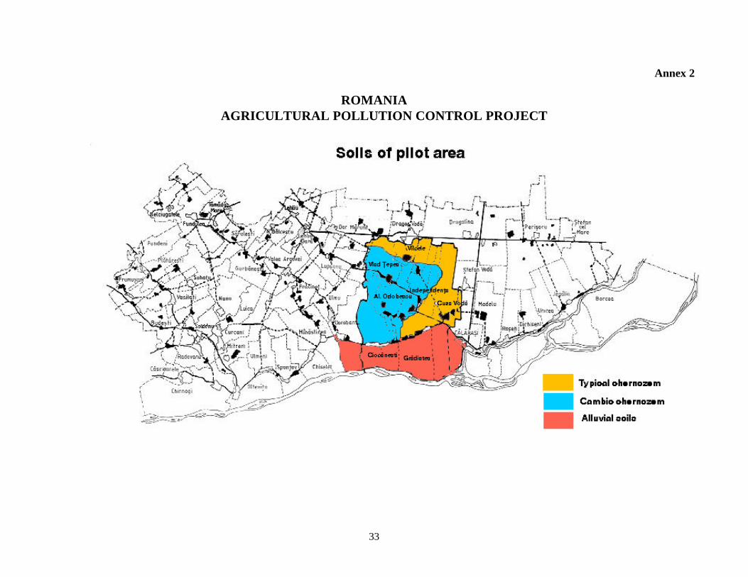
33
Annex 2
ROMANIA AGRICULTURAL POLLUTION CONTROL PROJECT

34
Annex 3
ROMANIA AGRICULTURAL POLLUTION CONTROL PROJECT
Code of Good Practices for the Protection of Water and
Soil within Boianu–Sticleanu Polder Area This Code of Good Practices is a succession of practical rules that should be obeyed by farmers within Boianu – Sticleanu polder: 1. Extension of agro-forestry systems such as windbreaks/shelterbelts, hedgerows, filter strips and narrow
vegetative barriers on land deemed as inadequate for agricultural purposes (with periodic waterlogging, rich in soluble salts or exchangeable sodium or with low fertility potential);
2. Cultivation of 25 – 30% of the arable areas with annual and perennial leguminous crops; 3. Reduction of tillage depth by 5 – 10 cm and gradual replacement of the traditional mouldboard plough
with conservation tillage and reduced tillage systems; 4. Combined utilization of existing drainage schemes, both for draining surplus water and for the
completion of crop water demand; 5. Crop irrigation using conventional clean water and application rates in correlation with the soil moisture
storage capacity. For the case of applying irrigation prior to sowing, the tilth depth would be of maximum 25 cm;
6. Crop fertilization using only solid organic and chemical fertilizers. Liquid fertilizers, with the exception
of the foliage-targeted ones, are forbidden from use; 7. Allowed organic fertilizers are: semi-digested manure, compost, vegetable rotten material, green
fertilizers and bacterial fertilizers; 8. The application rate for semi-digested manure and compost should be of maximum 10 t/ha and year.
For a 4-5 year rotation, the maximum rate is 40 – 50 t/ha. Manure would only be applied during July – October interval, as the main fertilizer, by even spreading on the land, immediately followed by soil incorporation using the disk-harrow, after which the land is ploughed;
9. Leguminous seed treatment using specialized bio-products (e.g., NITRAGIN) for peas, beans, soya-
bean, alfa-alfa, etc. Dosage: 4 bottles (200 – 250 ml each) for the amount of seed required for one hectare;
10. Growing green fertilizers and incorporating them into the soil, together with all the crop residue (straw,
sunflower stems, weeds, etc.). Field burning of various straw, stems and other crop residue is definitely prohibited;
11. Accurate chemical fertilizer dosage application, in accordance with the requirement of each crop,
corrected by the soil’s agro-chemical indices and by the previously used agricultural technology; 12. The use on nitrogen-based (urea, ammonium nitrate, ammonium sulphate, etc.) and foliage-targeted
fertilizers should only occur in the spring and summer (during the vegetation season) and phosphorus & potassium-based fertilizers should be applied during summer and autumn, prior to ploughing. Complex

35
NP and NPK type fertilizers should be applied before or during sowing, the maximum rate being 50 kg N/ha;
13. Organic and chemical fertilizers would only be spread using terrestrial mechanized means, localized and
in an evenly manner; 14. Reduction by 10-20% of the chemical fertilizers’ amount, for the case of localized application using the
F6-8 fertilizing machine; 15. Unilateral nitrogen fertilization is forbidden and no un-wrapped organic or chemical fertilizer amount
should be allowed to be stored onto the soil, not even on a temporary basis; 16. Only authorized pesticides (herbicides, insecticides, fungicides) should be utilized in the way specified
in their authorization. Field spreading only using terrestrial means is advisable; 17. All chemicals, including their wrappings should only be deposited in specially designated places,
previously approved by the Environmental Protection Agency; 18. Grazing should be performed in dry soil conditions and during winter. It is preferable to graze only
sheep and young cattle. The optimum values of animal load are 1.5 – 2.0 livestock units per hectare.
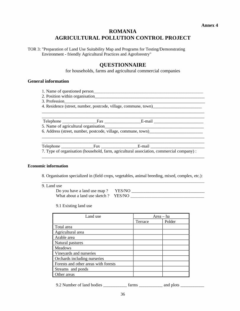
36
Annex 4 ROMANIA
AGRICULTURAL POLLUTION CONTROL PROJECT
TOR 3: "Preparation of Land Use Suitability Map and Programs for Testing/Demonstrating Environment - friendly Agricultural Practices and Agroforestry"
QUESTIONNAIRE for households, farms and agricultural commercial companies
General information 1. Name of questioned person___________________________________________________ 2. Position within organisation___________________________________________________ 3. Profession_________________________________________________________________ 4. Residence (street, number, postcode, village, commune, town)_______________________ ___________________________________________________________________________ ___________________________________________________________________________ Telephone ________________Fax _________________E-mail _______________________ 5. Name of agricultural organisation______________________________________________ 6. Address (street, number, postcode, village, commune, town)_________________________ ___________________________________________________________________________ ___________________________________________________________________________ Telephone _______________Fax _________________E-mail _________________________ 7. Type of organisation (household, farm, agricultural association, commercial company) : ___________________________________________________________________________ Economic information 8. Organisation specialized in (field crops, vegetables, animal breeding, mixed, complex, etc.): ___________________________________________________________________________ 9. Land use Do you have a land use map ? YES/NO __________________________________ What about a land use sketch ? YES/NO __________________________________ 9.1 Existing land use
Land use Area – ha Terrace Polder Total area Agricultural area Arable area Natural pastures Meadows Vineyards and nurseries Orchards including nurseries Forests and other areas with forests Streams and ponds Other areas
9.2 Number of land bodies ___________ farms ___________ and plots ___________

37
10. Cropping system: 10.1 Crop rotation _____________________________________________________ ___________________________________________________________________________ 10.2 Soil tillage _______________________________________________________ ___________________________________________________________________________
10.3 Chemical fertilisers and their application____________________________________ ___________________________________________________________________________ 10.4 Pesticides_________________________________________________________ ___________________________________________________________________________ 10.5 Irrigation_________________________________________________________ ___________________________________________________________________________ 10.6 Crop residue management:__________________________________________ ___________________________________________________________________________
10.7 Crops, corresponding areas and yields for the last 10 years Year S
(ha) Y (t/ha)
S (ha)
Y (t/ha)
S (ha)
Y (t/ha)
S (ha)
Y (t/ha)
S (ha)
Y (t/ha)
11. Animal breeding 11.1 Livestock species and breeding system
Livestock Number Breeding system
11.2 Waste management_________________________________________________ ___________________________________________________________________________ ___________________________________________________________________________ 12. Income generated by: Crops (ROL) __________________________________________________ Stock breeding (ROL) _________________________________________________
13. Incurred debts (ROL): _____________________________________________________________
38
Social information 13. Current number of landowners ______________ and trend ________________________ 14. Annual lease______________________________________________________________ ___________________________________________________________________________ 15. Main agricultural extension services sources ___________________________ ___________________________________________________________________________ Have you ever heard of agroforestry practices? YES/NO Did it ever occur to you, to convert your existing organisation to organic agriculture ? YES/NO Environmental information 16. Soil types:________________________________________________________________ ___________________________________________________________________________ Are the soil data useful to you ? YES/NO When did you order the last agrochemical study/survey?___________________________________
17. Water sources (ground water, rivers, lakes, ponds)________________________________ ___________________________________________________________________________
Did you ever use climatic data for organisation management purposes? YES/NO 18.Main flora species__________________________________________________________ ___________________________________________________________________________ ___________________________________________________________________________ 19. Main fauna species ________________________________________________________ ___________________________________________________________________________ 20. Problems encountered: Economic problems___________________________________________________ ___________________________________________________________________________ ___________________________________________________________________________ Social problems________________________________________________________ ___________________________________________________________________________ ___________________________________________________________________________ Ecological problems____________________________________________________ ___________________________________________________________________________ ___________________________________________________________________________ 21. Equipment & machinery owned (tractors, lorries, combine harvesters, loaders, carts, etc.)
Equipment Number Condition
Other relevant information: ____________________________________________________________________________________________________________________________________________________________________

39