Embed Size (px)
Citation preview
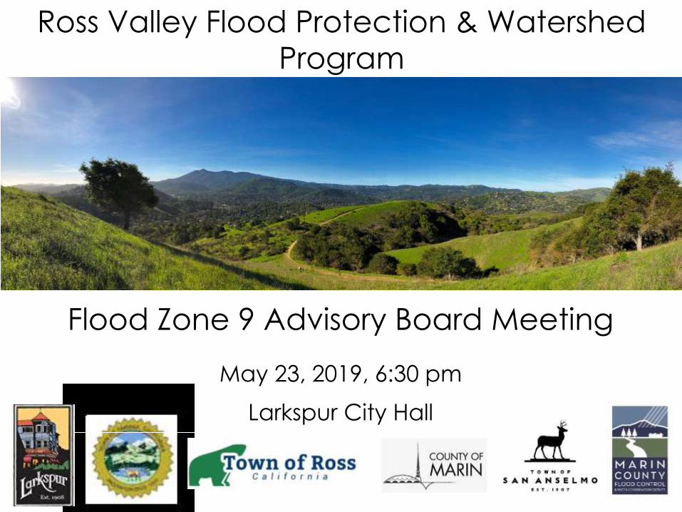
Flood Zone 9 Advisory Board Meeting
May 23, 2019, 6:30 pm
Larkspur City Hall
Ross Valley Flood Protection & Watershed
Program

1. Program Work Plan Update
2. Lower Corte Madera Creek Program Activities
3. Corte Madera Creek Flood Risk Management Project Update
2
Presentation Agenda

Hillview Neighborhood Pump Station & Storm Drain Improvement Project
San Anselmo Flood Risk Reduction Project
2019 – 2027 Project/Study Work Plan Timeline
2019 2020 2021 2022 2023 2024 2025 2026 2027
Corte Madera Creek Flood Risk Management Project - Ph. 1 (Transition to Locally Managed)
Corte Madera Creek Flood Risk Management Project - Ph. 2
Lower Corte Madera Creek & Geomorphic Dredge Study
Morningside/Sleepy Hollow Creek Study
Azalea Ave. Bridge
Madrone Ave. & Nokomis Ave. Bridges
Winship Ave. Bridge
Bridge Ave & Sycamore Ave./Center Blvd. Bridges
Program Environmental Impact Report
Annual Ross Valley Creek Maintenance
Flood Risk Reduction Project(Project Lead – Zone 9)
Flood Risk Reduction Project(Project Lead – Town/City)
Feasibility Evaluation/Study
Removed from Work Plan
May 2019

1. Hydraulics Overview & Dredging Analysis Findings James Reilly (Stetson Engineers)
2. Geomorphic Dredge Study Update Roger Leventhal (FC District)
3. Lower CMC Improvement Study Update Hugh Davis (FC District)
4. Hillview Pump Station & Stormdrainage Project Update Julian Skinner (Larkspur)
4
Lower Corte Madera Creek - Program Activities

Lower Corte Madera Creek

6
• Dredging Not a Sustainable Measure Considering;
o Sedimentation rates are high (results temporary)
o Re-occurring costs without secure funding source
o Rigorous environmental regulatory permitting
o Limited dredge material disposal options
o Sea level rise
• Planning Underway to Evaluate Flood Mitigation Opportunities;
o Levees/berms, tides gates and other restoration
o Alternatives to traditional dredge – geomorphic dredge
o Regional sea level rise adaptation planning
Flood Mitigation Activities in Lower Corte Madera Creek

1. Hydraulics Overview & Dredging Analysis Findings James Reilly (Stetson Engineers)
2. Geomorphic Dredge Study Update Roger Leventhal (FC District)
3. Lower CMC Improvement Study Update Hugh Davis (FC District)
4. Hillview Pump Station & Stormdrainage Project Update Julian Skinner (Larkspur)
7
Lower Corte Madera Creek - Program Activities

8
• James Reilly presents hydraulic modeling video of watershed and Lower Corte Madera Creek
Hydraulics of Corte Madera Creek

9
VIDEO ONE OF TWO – FORSEABLE PROJECT CONDITIONS (UPSTREAM PLANNED PROJECTS IN PLACE) – 100-YEAR SIMULATED RIVERINE FLOOD EVENT
Hydraulics of Corte Madera Creek
Click on image above or go to: https://vimeo.com/338332202

10
Hydraulics of Corte Madera Creek
Click on image above or go to: https://vimeo.com/338301439
VIDEO TWO OF TWO (ZOOMED IN ON KENTFIELD/LARKSPUR)–FORSEABLE PROJECT CONDITIONS (UPSTREAM PLANNED PROJECTS IN PLACE AND LOCAL LEVEE EVALUTION FOCUS AREAS) – 100-YEAR SIMULATED RIVERINE FLOOD EVENT
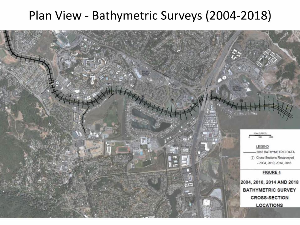
Plan View - Bathymetric Surveys (2004-2018)
11

Profile of Bottom of Earthen Channel
12
13
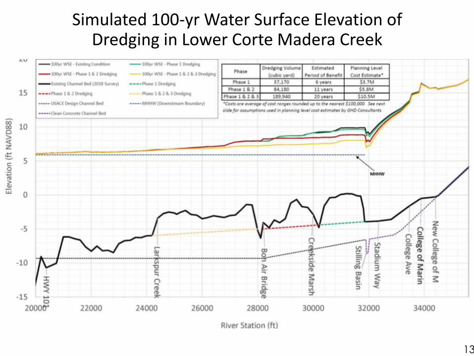
Simulated 100-yr Water Surface Elevation of Dredging in Lower Corte Madera Creek

Dredge Option Quantity ~Cost* Estimate Dredge
Frequency
Phase 1 End of concrete channel to north-end of Creekside Marsh
37,170 cy (cubic yards)
$3.1M to $4.2M 6 year
$500k CEQA/permitting/Engineering, $360k for Construction Management + other assumptions/costs below
Phase 1 + 2 End of concrete channel to Bon Air Rd Bridge
84,180 cy $4.5M to $7M 11 year
$575k CEQA/permitting/Engineering, $540k for Construction Management + other assumptions/costs below
Phase 1 + 2 + 3 End of concrete channel to Larkspur Creek
189,940 cy $7.7M to $13.2M 20 year
$650k CEQA/permitting/Engineering, $960k for Construction Management + other assumptions/costs below
*Assumptions are preliminary. Constructability constraints and associated costs not fully explored under conceptual design and may impact final costs. (1) Assumes 2019 construction year, 25% contingency(2) Costs include design, permitting, $1M mobilization/demobilization, construction management (no construction
and/or post-construction monitoring costs included). Actual costs may vary substantially under future bidding conditions
(3) Assumes $20 to $40 per cy sediment removal and that dredge sediments are suitable for disposal off-shore at DODS. Dredging is assumed as clamshell and barge. Hydraulic dredging and local disposal option costs may be very different. Barge access may impact costs.
REFERENCE: Range of Probable Costs for Dredging Analysis

1. Hydraulics Overview & Dredging Analysis Findings James Reilly (Stetson Engineers)
2. Geomorphic Dredge Study Update Roger Leventhal (FC District)
3. Lower CMC Improvement Study Update Hugh Davis (FC District)
4. Hillview Pump Station & Stormdrainage Project Update Julian Skinner (Larkspur)
15
Lower Corte Madera Creek - Program Activities

The “Geomorphic Dredge Design” Approach to Channel Maintenance Dredging Applied to Corte Madera Creek
marinwatersheds.org
Roger Leventhal, P.E.
Senior Engineer
DPW Flood Control
Laurel Collins
Watershed
Sciences
Presentation to the Zone 9
AG May 23, 2019

Bay Dredging Realities 2019• Costs for dredging and disposal have increased substantially in SF
Bay since the 60s and 80s
• No local upland fill disposal sites (like in 1960s)
• In-bay disposal sites (SF10/11) not likely available for large projects
• Permit fees exploding
o Novato RWQCB dredge fees = $5,000 (2012) $60,000 (2016) and expected to be over $100k in 2020 (just one agency example)
• Permitting now requires expensive mitigation (costs for impacts to the environment)
• Barge access issues may impact costs

Current Creek Dredge and Disposal Costs
• Costs now likely in the $30 to $70/cubic yard range (highly variable)
o Original Corps volume (1966)~ 675,000cy
o Reset Dredge (1986) ~ 450,000cy
o Stilling Basin (1998) ~ 22,000cy
• Benefits don’t last – sometimes just a few years
• The original design approach for channel dredging may be cost-prohibitive
✓ Interest in alternative design approaches led to the “geomorphic dredge design” approach for consideration tonight

Goals of the Geomorphic Design Approach
• A lower total life-cycle cost (capital plus maintenance) – more self-sustaining
• Provide some flood and navigation benefits
• No degradation of existing conditions and no adverse impacts to existing users
• Work with natural forces to maintain
• Provide sustainable deeper water to allow extension of pipe outfalls – may help with drainage
• Lower permitting and mitigation costs
• Set-up potential grant funding opportunities

One sentence summary of “geomorphic dredge” design approach
“A dredging plan developed for tidal creek channels designed to be in equilibrium with the available areas of connected tidal marsh (tidal prism)...…and thus intended to work with the natural forces of the tides to transport sediment and maintain itself over time”
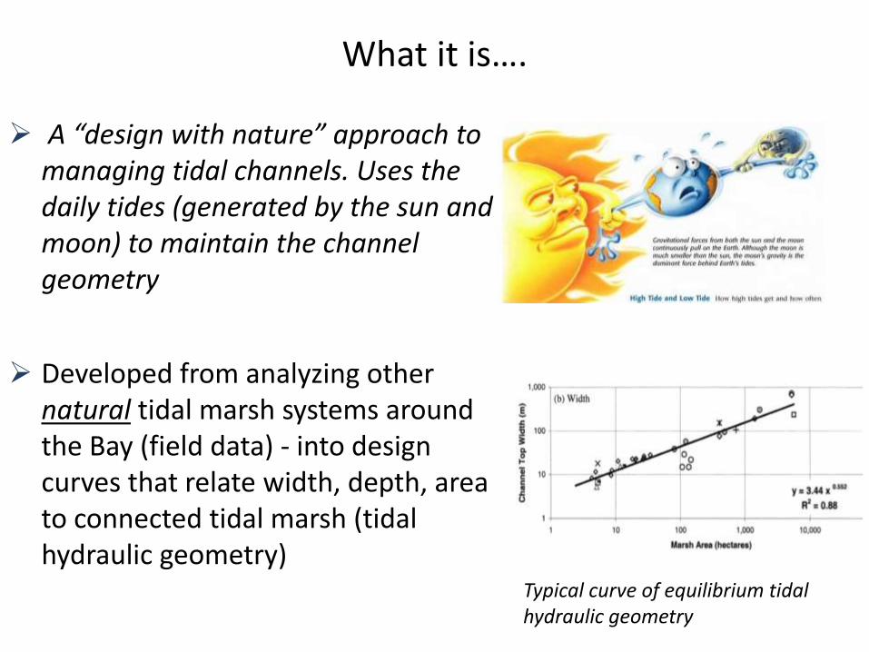
What it is….
➢ A “design with nature” approach to managing tidal channels. Uses the daily tides (generated by the sun and moon) to maintain the channel geometry
➢ Developed from analyzing other natural tidal marsh systems around the Bay (field data) - into design curves that relate width, depth, area to connected tidal marsh (tidal hydraulic geometry)
Typical curve of equilibrium tidal hydraulic geometry

What it is (#2)….
➢ Not the solution to all problems; provide some flooding or navigation benefits but not primary design goals
➢ It’s a pilot proposal . Based on sound science and supported by the permitting agencies (big plus) - but required new dataset for larger channels which was focus of project work with uncertainties
➢ Applicable where tides are the dominant channel forming and maintaining process
➢ Not a total restoration – designed into existing creek ROW
✓ Primary design focus is channel sustainability over time (= less dredging and costs)

Natural Tidal Channels w/Connected Marsh Don’t Need Dredging
Petaluma Creek tidal channels

In the 1800s Barges Sailed Up CM Creek
Ross Landing in Corte Madera Creek
Cooly LandingEden LandingRoberts LandingPetaluma etc…
From “A History of Corte Madera” Haehl 2002
“
“
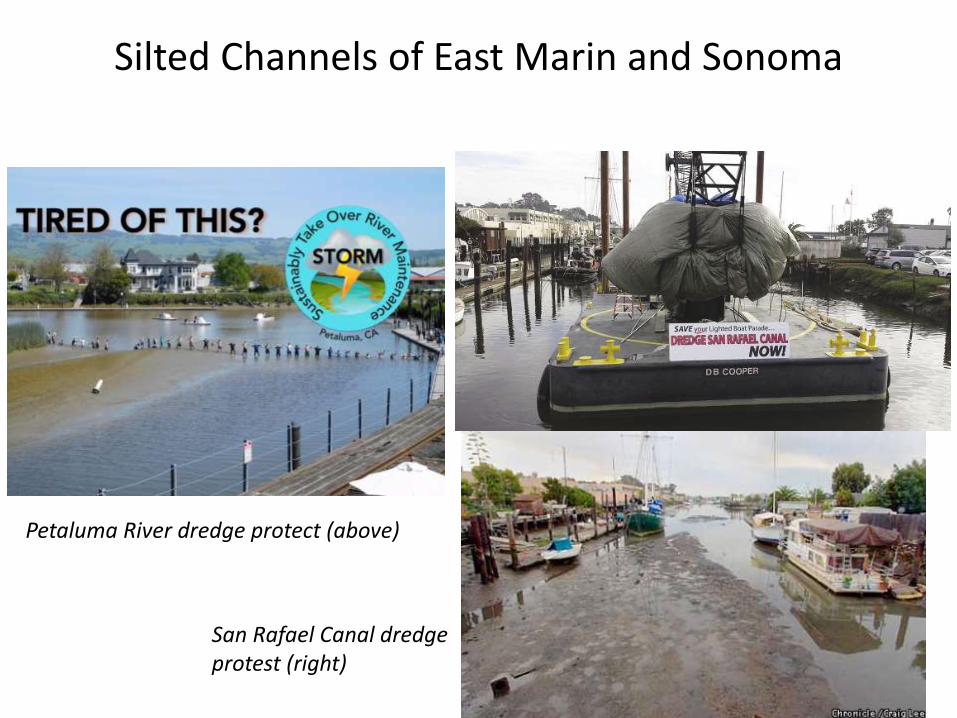
Silted Channels of East Marin and Sonoma
Petaluma River dredge protect (above)
San Rafael Canal dredge protest (right)

Main Reason for Channel Siltation …
Loss of Tidal Wetlands (primary reason and focus of the geomorphic dredge approach)
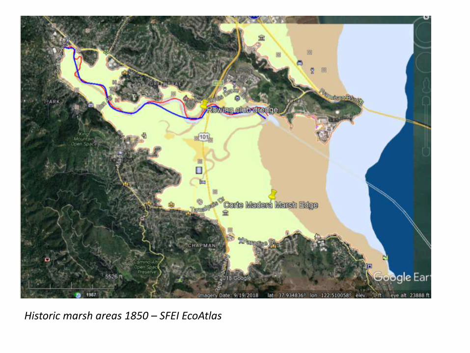
Historic marsh areas 1850 – SFEI EcoAtlas

Modern connected tidal marsh areas – much less so channel is adjusting naturally

Corte Madera Creek Changes
Historic/Modern Marsh
Area
(acres)
Channel
Length (ft)
Sinuosity
Historic 900 19,214 1.24
Modern 274 17,132 1.15
Change from Historic Loss of
70% to
80%
Loss of
approx.
2,000 lf

Original Corps Channel Design …
1. Straightened, deepened and widened the channel
2. Relied on inexpensive dredging to maintain flood capacity
3. Based on earlier understandings of sediment transport and before computer models

Evolution in Water Engineering …

Started to Change in the 1960s and 70s

Modern Engineering – Work with Natural Forces Where Possible
https://ewn.el.erdc.dren.mil/

Science Based DesignThe Geodredge Updated Design Curves…
• Series of plots of width, depth and area to connected tidal marsh area (tidal prism)
• Prior plots developed in 2002 and lumped all types of marshes into single plots
• Marin geodredge project spent two years developing new plots in great detail for large fluvial-tidal channels – the ones that get dredged (Coyote, ACMdP, CM, SR Canal, Gallinas, Novato…)

One of Many New Design Curves
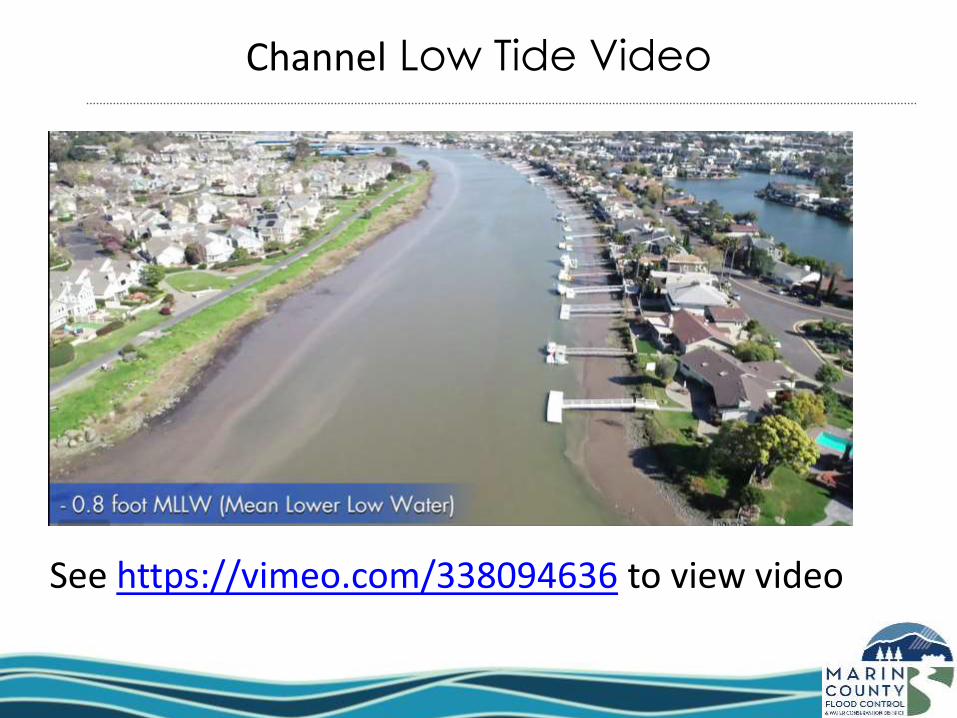
See https://vimeo.com/338094636 to view video
Channel Low Tide Video

Applied to Corte Madera Creek
Draft geomorphic dredge concept design for Corte Madera Creek (inner green lines)

Why There Is Deeper Water At The Inside of Channel Bends
The natural tendency of
creeks is to fill-in the inner
bends and keep deeper
part of creek at outer part of
the bend

Range of Conceptual Design Construction Costs ($) –Geomorphic Dredge (Earthen Channel to Bay)
Dredge Option
Quantity Unit Cost Cost (2019 $) Notes
Geomorphic Dredge of Corte Madera Creek Channel
90,000 cubic yards (note: high end estimate of volume)
~$35/cubic yards (low end) to ~$60/cubic yard (high end)
~$3.15M (low end) to~$5.4M (high end
Assumes the higher quantity geodredge option with dredging occurring from about Lot 13 (College of Marin parking) down to the Bay (Drakes Cove Road).
Includes overdredge volume of approximately 26,000cy for constructability side slopes and one foot overdepth
Costs are preliminary and for comparison between alternatives. Constructability constraints and associated costs not fully explored under conceptual design and may impact final costs. (1) Unit Costs includes design, permitting, mob/demob, construction monitoring and a 25% contingency. Actual
costs may vary substantially under future bidding conditions(2) Assumes dredge sediments are suitable for disposal off-shore at DODS. Dredging is assumed as clamshell
and barge. Hydraulic dredging and local disposal option costs may be very different. Barge access may significantly impact costs.

Summary - Why consider a geomorphic approach to dredge design?
1. Channel should be more self-sustaining and require less frequent dredging
2. Easier to permit and less mitigation costs
3. Possible grant funding opportunities? (unknown)
4. Less volume = less often = less costly lifecycle
However the trade-off is less depth and width and may not dredge next to structures – flood protection and navigation are not specific design goals – may not meet community goals for a dredging project

Next Steps…
• Further develop concept plans
• Prepare grant ask for Measure AA in Fall?
• RWQCB is supportive of combined geodredge with beneficial reuse project –grant funding?
Title Page of Not Yet Completed Report
INCOMPLETE DRAFT- NOT AVAILABLE
DRAFT NOT AVAILABLE

1. Hydraulics Overview & Dredging Analysis Findings James Reilly (Stetson Engineers)
2. Geomorphic Dredge Study Update Roger Leventhal (FC District)
3. Lower CMC Improvement Study Update Hugh Davis (FC District)
4. Hillview Pump Station & Stormdrainage Project Update Julian Skinner (Larkspur)
42
Lower Corte Madera Creek - Program Activities

43
Lower Corte Madera Creek Improvement Study
Goals:
1. Evaluate current flood capacity and assess need for improvements
2. Based on need, develop potential scenarios for improved capacity that consider future sea level rise
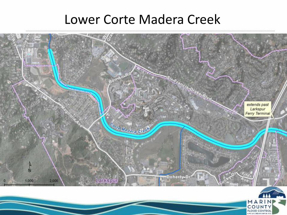
Lower Corte Madera Creek

Lower Corte Madera Creek Improvement Study
Completed:
• Bathymetric Survey
• Updated Hydraulic Modeling
• Geotechnical Exploration
• Levee Assessment
In Process:
• Develop and Evaluate Alternatives for Flood Mitigation
Improvements

Alignments for Analysis
46
HILLVIEW
KENTFIELD
GARDENS
COLLEGE
COURT
SO. ELISEO
DRIVE
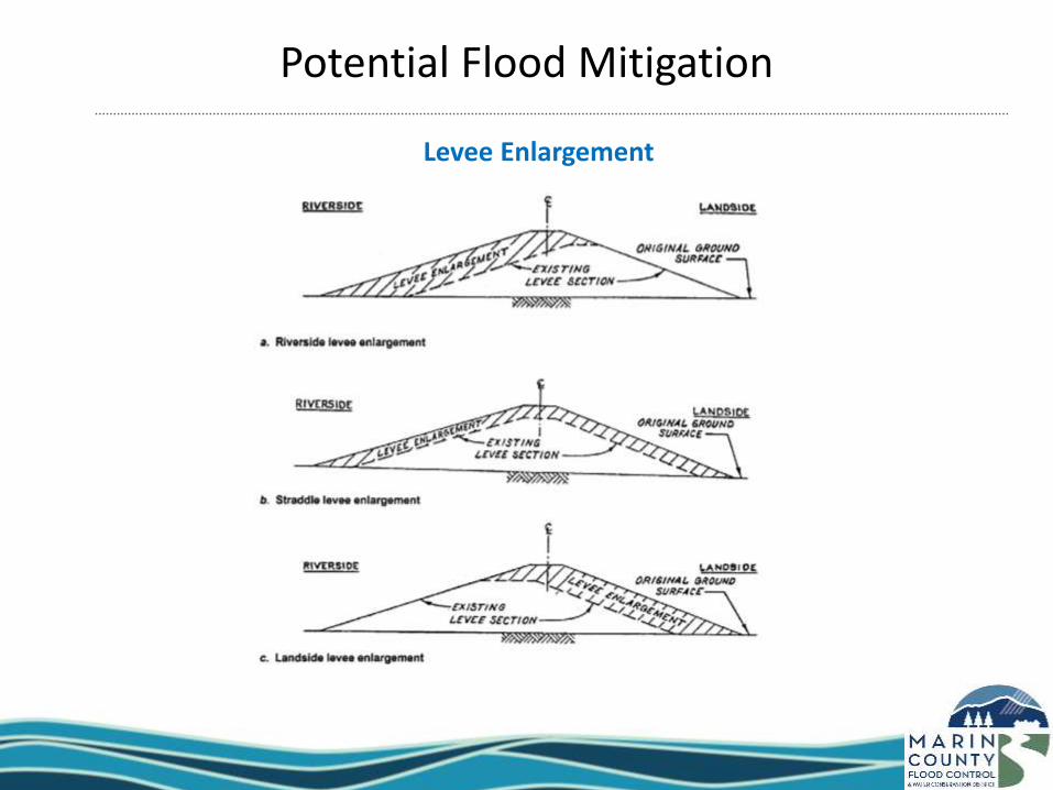
Potential Flood Mitigation
Levee Enlargement
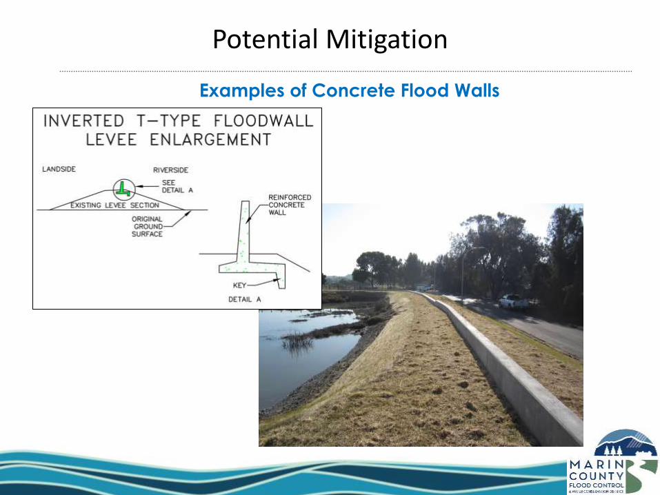
Potential Mitigation
Examples of Concrete Flood Walls

Potential Flood Mitigation
Examples of Sheet Pile Flood Walls
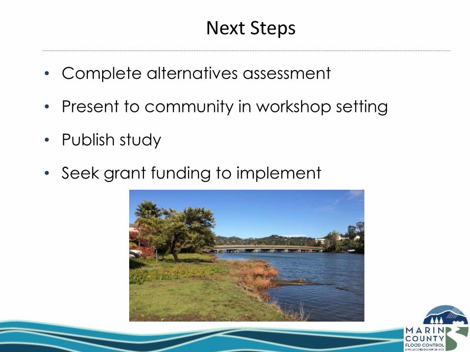
Next Steps
• Complete alternatives assessment
• Present to community in workshop setting
• Publish study
• Seek grant funding to implement
1. Hydraulics Overview & Dredging Analysis Findings James Reilly (Stetson Engineers)
2. Geomorphic Dredge Study Update Roger Leventhal (FC District)
3. Lower CMC Improvement Study Update Hugh Davis (FC District)
4. Hillview Pump Station & Stormdrainage Project Update Julian Skinner (Larkspur)
52
Lower Corte Madera Creek - Program Activities
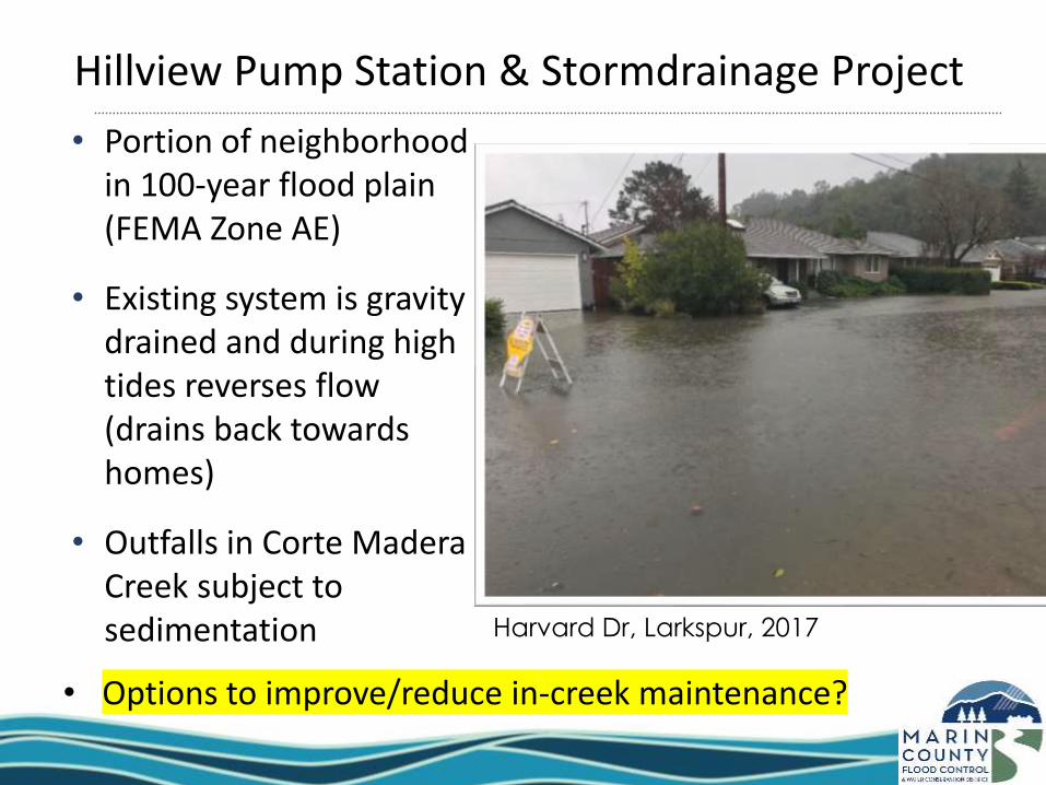
Hillview Pump Station & Stormdrainage Project
Harvard Dr, Larkspur, 2017
• Portion of neighborhood in 100-year flood plain (FEMA Zone AE)
• Existing system is gravity drained and during high tides reverses flow (drains back towards homes)
• Outfalls in Corte Madera Creek subject to sedimentation
• Options to improve/reduce in-creek maintenance?

Hillview Outfalls

Hillview Outfalls
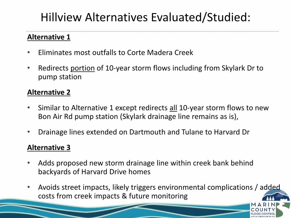
Alternative 1
• Eliminates most outfalls to Corte Madera Creek
• Redirects portion of 10-year storm flows including from Skylark Dr to pump station
Alternative 2
• Similar to Alternative 1 except redirects all 10-year storm flows to new Bon Air Rd pump station (Skylark drainage line remains as is),
• Drainage lines extended on Dartmouth and Tulane to Harvard Dr
Alternative 3
• Adds proposed new storm drainage line within creek bank behind backyards of Harvard Drive homes
• Avoids street impacts, likely triggers environmental complications / added costs from creek impacts & future monitoring
Hillview Alternatives Evaluated/Studied:

Hillview Pump Station & Stormdrainage Project

Budget/Schedule
• Zone9 FY 19/20 approved up to
$910k through construction
planning (initial concept/study
funded in part by Zone 9 up to
$42,000)
• City funded portions including
through FHWA Bridge funding
administered through Caltrans
and future paving following
project
• Complete PS&E in FY 19/20,
construct FY 20/21
Hillview Pump Station & Stormdrainage Project

Corte Madera Creek Flood Risk Management Project

Next Steps Underway
1. Since March 2019 AB recommendation, District staff working
with USACE to suspend feasibility cost share agreement.
• Staff will present at June/July District Board of Supervisor
meeting to finalize action.
2. Working with Town of Ross, environmental resource agencies
and other stakeholders to develop refined project concept and
tentative schedule including new CEQA process.
• Conducting technical analysis to support project description.
60
Corte Madera Creek Flood Risk Management Project
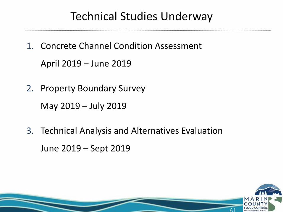
Technical Studies Underway
1. Concrete Channel Condition Assessment
April 2019 – June 2019
2. Property Boundary Survey
May 2019 – July 2019
3. Technical Analysis and Alternatives Evaluation
June 2019 – Sept 2019
61

62
June/July 2019Formalize Suspension of USACE-District Feasibility Cost Share Agreement at District BOS
Sept 2019Project Description Developed (Preliminary Technical Studies Complete)
Sept - Oct 2019 Present Project Description at Community Meetings & MOA with Town of Ross for Ongoing Collaboration
Oct - Dec 2019Project EIR – Notice of Preparation, Scoping Period & Public Hearing
Apr - May 2020Draft EIR Complete, Public Comment Period & Public Hearing
Aug - Sept 2020Final EIR Complete, Public Comment Period, Public Hearing and Certification
Oct 2020Final Design Contract &Construction Agreements with Town of Ross
Sept 2020 - Apr 2021 Final Design & Permitting
Oct 2021 - Oct 2022 Construction
Tentative Project Schedule (Date Subject to Change)

Questions
Sign up for email alerts about meetings and program updates at www.RossValleyWatershed.org
63