Embed Size (px)
Citation preview

Route Planning and Evaluation in the Canadian Arctic using POLARIS
Presented By: Mark Stoddard Dept. of Industrial Engineering Dalhousie University Co-Authors: Dr. Laurent Etienne, University of Tours, France Dr. Ron Pelot, Dalhousie University

OUTLINE
• Research Objectives
• Ship Observations in Ice
• POLARIS
• Route Planning and Evaluation
• Future Work

The Canadian Arctic presents a unique
operating environment where first-hand
experience is limited, and risks are widely known but not well understood.

Basic Research Objectives
1. Survey existing risk assessment frameworks and relevant data sources supporting Arctic maritime risk assessment
2. Develop and test new concepts for calculation, visualization, and communication of voyage / route / area risk.
3. Improve understanding of the value of information for maritime decision making

Ship Observations Along a Route - Planned
Nuuk, Greenland
Devon Island, NWT

Ship Observations Along a Route - satAIS
Nuuk, Greenland
Devon Island, NWT

Ship Observations Along a Route - GPS
Nuuk, Greenland
Devon Island, NWT

What is going on here?

The view from the ship

Lets see the ice analysis

We have the ice analysis and the polar classification of the ship … Now what?

Polar Operational Limitations Assessment Risk Indexing System (POLARIS)
• Proposed risk assessment framework for determining ship operational limits in ice
• Produced by the International Association of Classification Societies (IACS)
• POLARIS provides a basic calculation to assess ship limitations based on a Risk Index Outcome (RIO)
nnRVCRVCRVCRIO ...2211

Polar Operational Limitations Assessment Risk Indexing System (POLARIS) – Risk Values
Summer Conditions Catego
ry
Ice Class
Ice Free
New
ice
Grey
Ice
Grey
Wh
ite Ice
Th
in F
irst Year Ice 1st
Stage
Th
in F
irst Year 2n
d Stage
Med
ium
First Year 1
st Stage
Med
ium
First Year 2
nd
Stage
Th
ick F
irst Year
Secon
d Year Ice
Ligh
t Mu
lti-Year ice
Heav
y M
ulti-Year ice
A
PC1 3 3 3 3 2 2 2 2 2 2 1 1 PC2 3 3 3 3 2 2 2 2 2 1 1 0 PC3 3 3 3 3 2 2 2 2 2 1 0 -1 PC4 3 3 3 3 2 2 2 2 1 0 -1 -2 PC5 3 3 3 3 2 2 2 2 1 -1 -2 -2
B PC6 3 2 2 2 2 1 2 1 0 -2 -3 -3 PC7 3 2 2 2 1 1 1 0 -1 -3 -3 -3
C
IA Super 3 2 2 2 2 1 1 0 -1 -3 -4 -4 IA 3 2 2 2 1 0 0 -1 -2 -4 -4 -4 IB 3 2 2 1 0 -1 -1 -1 -2 -4 -5 -5 IC 3 2 1 0 -1 -2 -1 -2 -3 -4 -5 -6 Not Ice Strengthened 3 1 0 -1 -2 -2 -2 -2 -3 -5 -6 -6

POLARIS RIO
POLARIS RIO
SCORE*
Escort or Independent?
Ice Regime (Ice Type and
Concentration)
Ship Class
Summer or Winter?
Risk Index Values
Operations Permitted
•RIO > 0
Limited Speed Operations permitted
•-10 <= RIO < 0
Escort Operations Permitted
•RIO + 10 >= 0 (escorted)
Escort Operations Permitted – Limited
Speed
•-10 <=RIO + 10<=0 (escorted)
Operations Not Permitted
•RIO < -10
•RIO + 10 < -10 (escorted)
* MSC 94 – Technical Background to POLARIS (2014)

POLARIS IN PRACTICE Polar Ship Category
Ice Class RIO Result
A
PC1 17 OP
PC2 13 OP
PC3 13 OP
PC4 6 OP
PC5 2 OP
Ice Conditions B PC6 -5 LS
PC7 -12 ONP
4/10 Second Year Ice, 3/10 Thick First Year Ice (Decayed), 3/10 Ice Free
C
IAS -12 ONP
1A -19 ONP
1B -19 ONP
1C -22 ONP
Not Ice Strengthened
-26 ONP

Ship Observations Along a Route - GPS
Nuuk, Greenland
Devon Island, NWT

POLARIS RIO Risk Map

Lets look more generally at a large Area of Interest (AOI)

Area of Interest

AOI RIO Visualization - Week 30

AOI RIO Visualization – Time Lapse

RIO Visualization - 52 week trend

RIO Visualization – Varying Ship Class
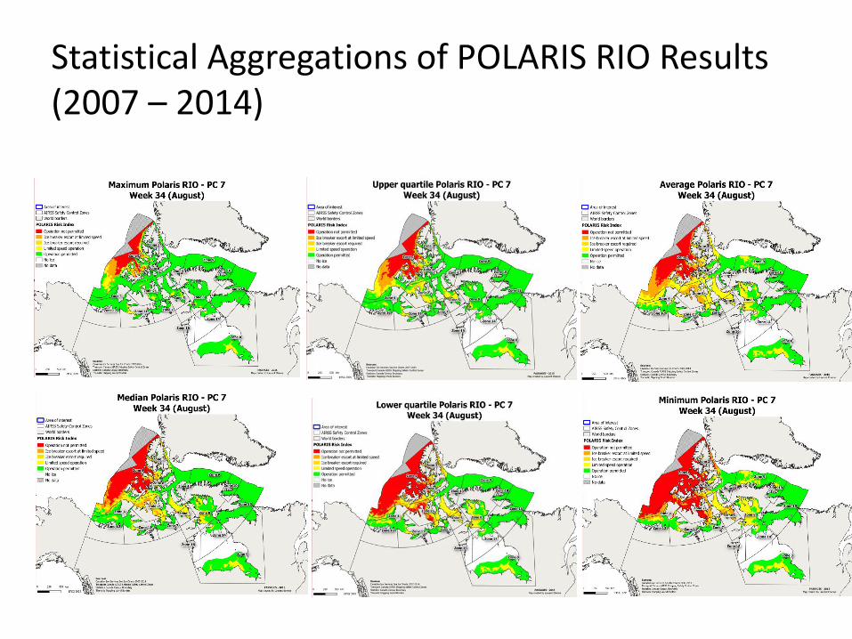
Statistical Aggregations of POLARIS RIO Results (2007 – 2014)

RIO Visualization – Route Planning and Evaluation

Conclusions
• Knowledge and understanding of the impact of ice on polar ship operations is required to make sense of ship observations
• Open-access sea-ice data from the Canadian Ice Service provides for rich analysis of the impact of ice on polar ship operations
• POLARIS provides a framework to assess and visualize the impact of ice on maritime traffic

QUESTIONS?