Embed Size (px)
Citation preview

Route & Site selection Surveys And
Clearances from Statutory Bodies in Pipeline Projects
U K Pal
on
08-07-09

Contents
• Concept of Route Survey & Types thereof• Reconnaissance Survey or “REKI”• Detailed Route Survey. • Cadastral Survey• ROW & its acquisition • Other Miscellaneous Surveys• Site selection for Terminals, Pump-stations,
Tank Farms, RCPs etc.• Clearances and permits from Statutory Bodies

What is Surveying?
Surveying is a pro-active action for collecting information/data for either
enabling a decision making process or for executing an activity in a Project
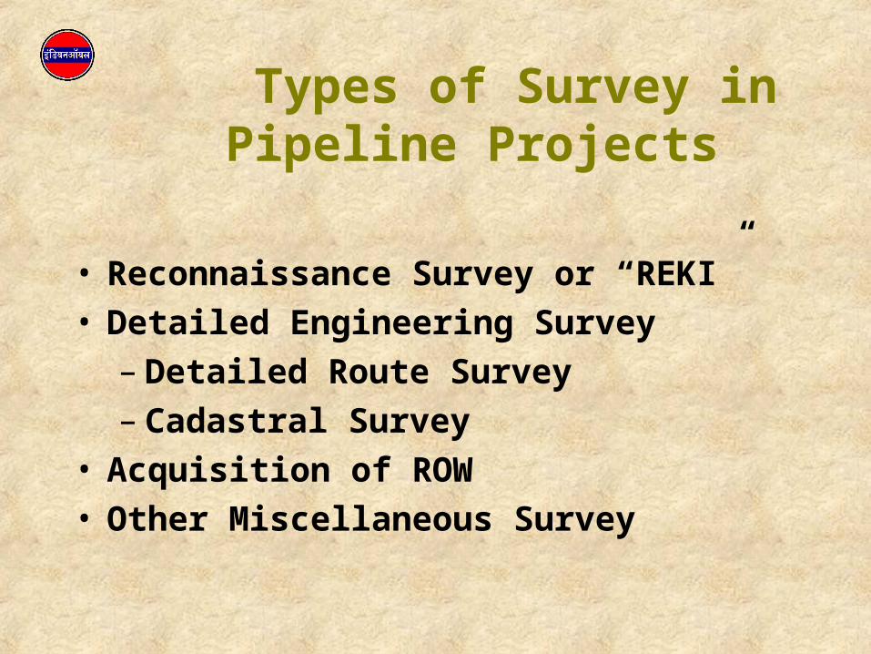
Types of Survey in Pipeline Projects
• Reconnaissance Survey or “REKI”• Detailed Engineering Survey
– Detailed Route Survey– Cadastral Survey
• Acquisition of ROW• Other Miscellaneous Survey
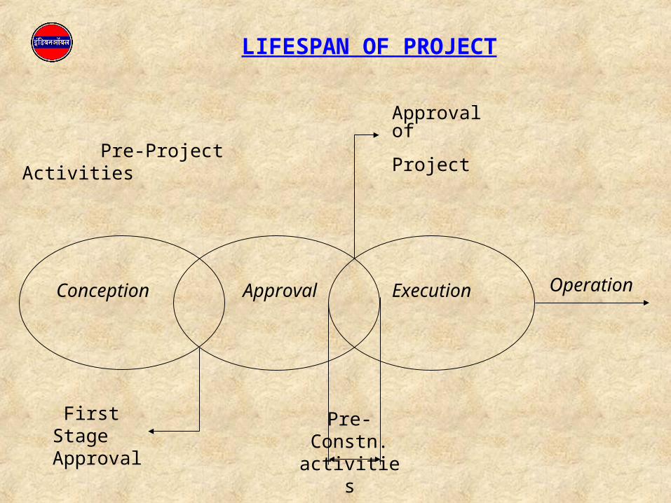
LIFESPAN OF PROJECT
Conception Approval Execution Operation
Approval of
Project Pre-Project Activities
First Stage Approval
Pre-Constn. activities

Surveying Activity vs Project Phase
• Reconnaissance Survey or “REKI”
• Detailed Route Survey. Also called as Detailed Engineering Survey
• Cadastral Survey – Acquisition of ROW
• Other Miscellaneous Survey
• Project Conceptual Stage – For FR Details
• After First stage clearance for Detailed Feasibility Report (DFR)
• Project Approval Stage-
Prior to Start of Field work for Mainline Laying
• As and when necessary

Reconnaissance Survey
• Carried out during Project Conceptual Stage
• The details are required for Feasibility Report
• A technically feasible shortest & cost-effective route is identified
• Various important features and information en-route that may affect the Project anyway are listed

Reconnaissance Survey
• Desk-Top study to identify various alternatives• Verification of ground truth• Establishing Ground Control Points• Listing of Crossings, details, rough profiles• Land-use pattern en-route• Development/expansion plan, contact Nos., addresses
of various Authorities• Unit rates of Materials and Manpower
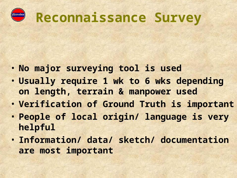
Reconnaissance Survey
• No major surveying tool is used• Usually require 1 wk to 6 wks depending on length,
terrain & manpower used• Verification of Ground Truth is important• People of local origin/ language is very helpful• Information/ data/ sketch/ documentation are most
important

Desk-Top Study
• Extensive use of SOI Topo-sheets• Few alternatives are chalked outs• Comparative merits/demerits are listed• GIS Packages are extremely helpful• Extensive Use of Satellite Imagery now-a-days


Route Finalisation
• To connect originating, terminating & obligatory points.
• To avoid densely populated area & city limits.
• To avoid reserved forest, wild life sanctuary, maritime zone.
• Passage through forest area should be minimum, if not avoidable.
• Approachability to ROW for maintenance.
• To avoid hilly and highly undulated zone/ broken lands.
• To avoid permanently marshy/ waterlogged/ flood prone area.
• To avoid mining areas.
• Minimum crossings.
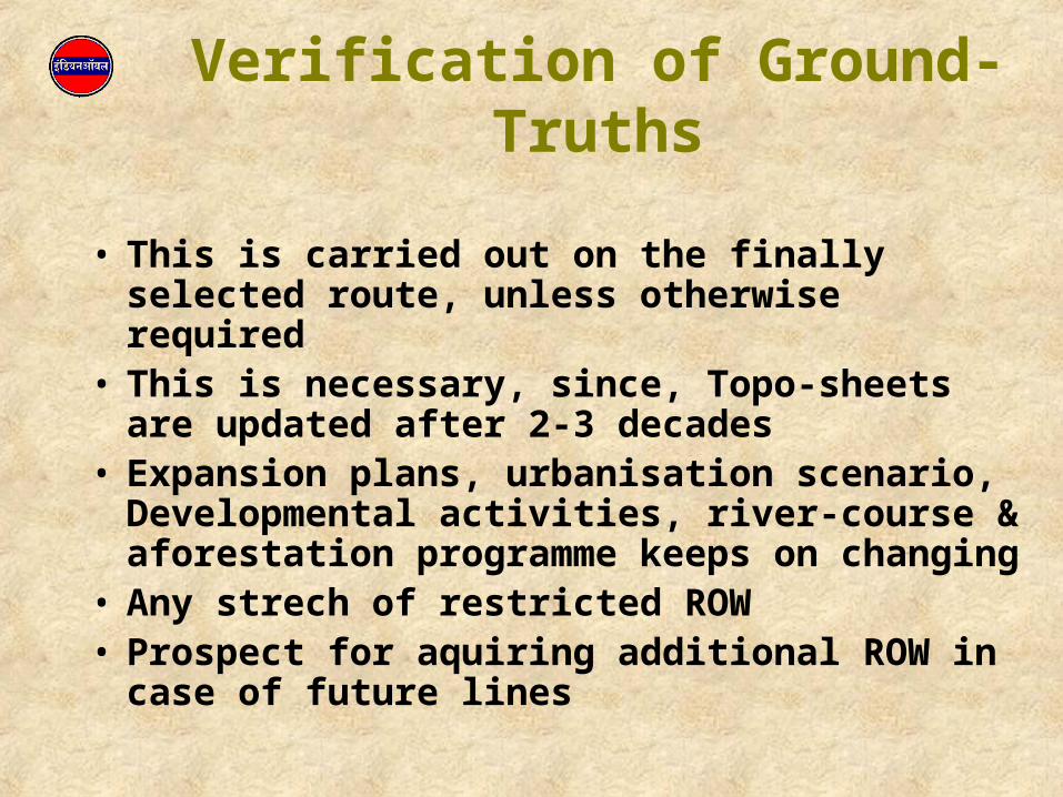
Verification of Ground-Truths
• This is carried out on the finally selected route, unless otherwise required
• This is necessary, since, Topo-sheets are updated after 2-3 decades
• Expansion plans, urbanisation scenario, Developmental activities, river-course & aforestation programme keeps on changing
• Any strech of restricted ROW• Prospect for aquiring additional ROW in case of
future lines

Establishing Ground-Control Points
• These should be at prominent places and easily identifiable at a later date
• Locations are serially documented w.r.t. nearby structures, KM post, Electric/ Telephone pole/tower etc.
• Should be well discussed with local villagers • Photographs may be taken for easy identification

Collection of Data
• River course profile with approximate dimensions• Sketches of Road crossings with future widening
plan, if any• Addresses, Telephone Nos. & contact persons of
Various authorities en-route• Unit cost of various construction materials and
manpower for estimation purpose

Detail Engineering Survey
• This activity is taken up during approval stage, when approval is considered almost certain
• Prior to this, route was on maps and paper. This is the first field activity taken up for Pipeline Projects
• Detailed Engineering Survey primarily consists of:– Detailed Route Survey &
– Cadastral Survey
Detailed Route Survey
• By this time, the obligatory points of the routes are already identified and the configuration of Pipeline is also known
• In this activity, route is progressively staked on ground preferably from one obligatory point and demarcated with TPs and IPs and related reference points.
• Exact distances between TPs & IPs, included angles, elevations etc. are accurately measured and recorded by theodelite /total stations
• The levels are taken at every 50 M distance of the staked route

Detailed Route Survey
• Crossing locations are identified and detailed dimensions are taken – A basis for detailed work estimate and tendering
• Salient features on both side of the staked routes are recoded and indicated on the route map prepared in a scale of 1: 10,000
• TPs, IPs & crossings are serially numbered and marked on route maps
• Profile Maps are prepared to a scale H 1:5000 & V 1:100
Right of Way (ROW) & Its acquisition
• Right of Way is acquired through PMP Act 1962
• Through this Act, Corporation acquires right of use of this land for laying a Pipeline, operating and maintaining the same by paying a specified compensation
• This is a very lengthy and complicated legal process, often dictating the total completion period of the Project
• Whenever ROW is acquired on a land, land use pattern can not be changed by the owner
• ROW acquisition is accomplished by dedicated team deputed for this purpose from state Land revenue deptt. Unless planned in advance and monitored properly, this activity is mainly responsible for time over-run

Cadastral Survey
• This is carried out for the purpose of ROW acquisition and calculation of compensation
• On village revenue maps, the ROW of 18 M width is plotted and affected survey nos. are identified.
• The area calculations are made and amount of compensation are calculated based on the prevalent land-rates
• Ownership records, e.g. 7/12 are sorted and compensation amount is disbursed before taking up pipe laying works
• During this survey, many diversions of route take place to accommodate unavoidable circumstances
ROW Acquisition
• The land schedule including ownership details are prepared and notification under section 3(i) and individual notices are issued
• Objection are heard by Competent Authority (CA) and these are either dismissed or held resulting in diversion
• After attending to objections, notification under section 6(i) and individual notices are issued
• The compensation is disbursed after hearing of objection, if any
• The acquisition process starts with collection of village revenue map and cadastral survey
• After payment of compensation, ROW can be opened by the owner for construction purpose

Other Miscellaneous Survey• Soil Investigation
• Soil Resistivity Survey
• Soil stratification Survey
• Soil Investigation and River Profile
• For taking up foundation Design
• Carried out at 500 M interval along the route at 1M, 1.5M, 2 M and 2.5M depth for CP design
• For ascertaining terrain details and taking proper care in Mainline tender for coating as well as earthwork
• For design of HDD crossings

Site Selection
Sites are selected for:
• Tank Farms Area as per requirement (> 60 – 70 acres )
• Pump Stations 10 – 12 acres• Delivery Stations 6 -10 acres• RCPs 0.5 acre• Valve Locations 5M x 5M
Permanent Land Acquisition Act 1894

Criteria for Site Selection
• Shall fall on selected route• Fairly level high-land requiring less earthwork• Easy Approachability through Major Road
(No Level – crossing or Road blocks in Approach)• Availability of Water & Power• Away from Urban Development and Residential
Area• Maintenance Facility nearby• Sub-soil Properties suitable for Required
Foundation Systems• Drainage outlet

CLEARENCES & PERMITS • Clearance from State Pollution Control Boards (NOC
through Public Hearing) Water preservation & Pollution Control Act 1974 amended in 1978 & 1988
• Forest clearance under Forest Act, 1980 amended in 1988• Consent to establish under water and Air Act from State
PCBs• Clearance from Mining Authorities (wherever required)
• ‘MOE&F’ clearance and clearance from Maritime Board &
CRZ Authorities (wherever applicable)• NOC from DMs of encountered districts• CCE and OISD clearance• Permits from Railway/ Irrigation/ Highway Authorities• Clearance from State fire Brigade• Factory license/ Clearance from Electrical Inspector.

Thank YouThank You