Embed Size (px)
Citation preview
rpsgroup.com.au
Local Structure Plan
Lots 114, 123 – 125 Frankland Avenue, Hammond Park
Prepared by:
RPS AUSTRALIA EAST PTY LTD
38 Station Street, Subiaco WA 6008 PO Box 465, Subiaco WA 6904
T: +61 9211 1111 F: +61 9211 1122 E: [email protected] Client Manager: Rob Sklarski – Principal Planner Report Number: 4036-1 Version / Date: Rev6, April 2014
Prepared for:
HAMMOND PARK ESTATES PTY LTD

Local Structure Plan Lots 114, 123 – 125 Frankland Avenue, Hammond Park
4036-1; Rev6, April 2014 Page i
IMPORTANT NOTE
Apart from fair dealing for the purposes of private study, research, criticism, or review as permitted under the Copyright Act, no part of this report, its attachments or appendices may be reproduced without the written consent of RPS Australia East Pty Ltd.
We have prepared this report for the sole purposes of Hammond Park Estates Pty Ltd (“Client”) for the specific purpose of only for which it is supplied (“Purpose”). This report is strictly limited to the purpose and the facts and matters stated in it and does not apply directly or indirectly and should not be used for any other application, purpose, use or matter.
In preparing this report we have made certain assumptions. We have assumed that all information and documents provided to us by the Client or as a result of a specific request or enquiry were complete, accurate and up-to-date. Where we have obtained information from a government register or database, we have assumed that the information is accurate. Where an assumption has been made, we have not made any independent investigations with respect to the matters the subject of that assumption. We are not aware of any reason why any of the assumptions are incorrect.
Document Status
Version Purpose of Document Orig Review Review Date Draft A Internal and client review RS SV 07/03/2013
Rev 1 Final for issue RS SV 11/03/2013
Rev 2 Incorporating City of Cockburn and WAPC recommended modifications SV RS 29/07/2013
Rev 3 Incorporating client comments and edits, for issue to City of Cockburn. SV RS 31/07/2013
Rev 4 Incorporating City of Cockburn edits for final adoption SV RS 05/11/2013
Rev 5 Incorporating WAPC edits for final adoption SV RS 05/02/2014
Rev 6 Incorporating final WAPC edits SV RS 03/04/2014
Approval for Issue
Name Signature Date
Rob Sklarski
03/04/2014
Local Structure Plan Lots 114, 123 – 125 Frankland Avenue, Hammond Park
4036-1; Rev6, April 2014 Page ii
Contents ENDORSEMENT PAGE ............................................................................................................................... 1
TABLE OF VARIATIONS ............................................................................................................................. 2
EXECUTIVE SUMMARY .............................................................................................................................. 3
PRE-LODGEMENT CONSULTATION .......................................................................................................... 4
PART ONE – STATUTORY SECTION ......................................................................................................... 5
PART 2 – NON STATUTORY EXPLANATORY SECTION ........................................................................... 7
1.0 BACKGROUND .................................................................................................................................. 8 1.1 Introduction ............................................................................................................................. 8
1.2 Location Details ...................................................................................................................... 8
1.3 Legal Description and Ownership .......................................................................................... 8
1.4 Existing and Surrounding Land Use ...................................................................................... 9
2.0 PLANNING FRAMEWORK ............................................................................................................... 10
2.1 Metropolitan Region Scheme ............................................................................................... 10
2.2 City of Cockburn Town Planning Scheme No. 3 .................................................................. 10
2.3 Southern Suburbs District Structure Plan Stage 3 .............................................................. 10
2.4 Directions 2031...................................................................................................................... 11
2.5 Liveable Neighbourhoods..................................................................................................... 12
2.6 State Planning Policy No. 3 – Urban Growth and Settlement .............................................. 12
2.7 City of Cockburn Local Commercial & Activity Centres Strategy ....................................... 13 2.8 Nearby Local Structure Plan Areas ...................................................................................... 14
3.0 SITE CONDITIONS AND ENVIRONMENT ....................................................................................... 15
3.1 Biodiversity and natural assets ............................................................................................ 15
3.1.1 Vegetation and flora ................................................................................................. 15
3.1.2 Fauna....................................................................................................................... 15 3.2 Landform and soils ............................................................................................................... 16
3.3 Groundwater and surface water ........................................................................................... 17
3.4 Bushfire hazard ..................................................................................................................... 17
4.0 INFRASTRUCTURE AND SERVICES .............................................................................................. 18
4.1 Existing and future transport infrastructure ........................................................................ 18
4.1.1 Existing networks ..................................................................................................... 18 4.1.2 Future networks ....................................................................................................... 18
4.2 Utilities services and infrastructure ..................................................................................... 19
4.2.1 Storm Water Infrastructure ....................................................................................... 19
4.2.2 Power Supply ........................................................................................................... 19
4.2.3 Water Supply............................................................................................................ 19
4.2.4 Sewer....................................................................................................................... 19
4.2.5 Communications....................................................................................................... 20
Local Structure Plan Lots 114, 123 – 125 Frankland Avenue, Hammond Park
4036-1; Rev6, April 2014 Page iii
4.2.6 Gas .......................................................................................................................... 20 5.0 LOCAL STRUCTURE PLAN ............................................................................................................ 21
5.1 Design principles .................................................................................................................. 21
5.2 Land Use................................................................................................................................ 21
5.3 Open Space ........................................................................................................................... 22
5.4 Residential ............................................................................................................................. 24
5.4.1 Dwelling type and distribution ................................................................................... 24
5.4.2 Dwelling yield and density estimates ......................................................................... 25 5.4.3 Variations to the Residential Design Codes 2013 ...................................................... 26
5.5 Movement networks .............................................................................................................. 26
5.5.1 Street Network ......................................................................................................... 26 5.5.2 Path Network............................................................................................................ 27
5.5.3 Public Transport ....................................................................................................... 27 5.6 Water management ............................................................................................................... 27
5.7 Education facilities................................................................................................................ 28
5.8 Activity centres and employment ......................................................................................... 28
5.9 Infrastructure coordination, servicing and staging ............................................................. 31
5.10 Developer contribution arrangements ................................................................................. 32
5.11 Detailed Area Plans ............................................................................................................... 32
6.0 CONCLUSION .................................................................................................................................. 34
Appendices Appendix 1: Environmental Summary Report
Appendix 2: EBPC Act Referral Documentation
Appendix 3: Flora and Vegetation Survey
Appendix 4: Graceful Sun Moth Survey and Habitat Assessment
Appendix 5: Fire Management Plan
Appendix 6: Transport Assessment Report
Appendix 7: Servicing Report
Appendix 8: Local Water Management Strategy
Local Structure Plan Lots 114, 123 – 125 Frankland Avenue, Hammond Park
4036-1; Rev6, April 2014 Page iv
Tables Table 1: Table of Variations to Part One and Structure Plan Map
Table 2: Structure Plan Summary Table
Table 3: Pre-Lodgement Consultation
Table 4: R-Code Variations
Table 5: Land Title Particulars
Table 6: SPP No.3 Policy Objectives and LSP Response
Table 7: Public Open Space Schedule
Table 8: Public Open Space Distribution
Table 9: Residential Lot and Dwelling Yield Estimates
Table 10: Residential Density Calculations
Table 11: Summary of LCACS Elements and Planning Responses
Figures Figure 1: Location Plan
Figure 2: Aerial Photograph
Figure 3: TPS Zoning Plan
Figure 4: Southern Suburbs Stage 3 District Structure Plan
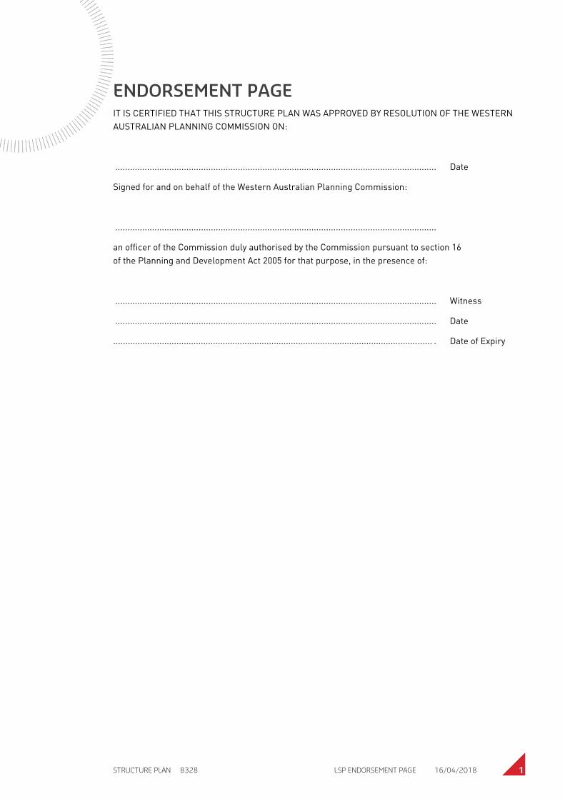
STRUCTURE PLAN 8328 LSP ENDORSEMENT PAGE 16/04/2018 1
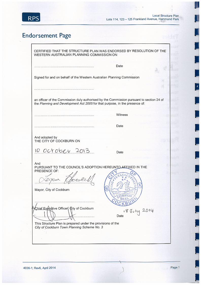
ENDORSEMENT PAGE IT IS CERTIFIED THAT THIS STRUCTURE PLAN WAS APPROVED BY RESOLUTION OF THE WESTERN
AUSTRALIAN PLANNING COMMISSION ON:
................................................................................................................................... Date
Signed for and on behalf of the Western Australian Planning Commission:
...................................................................................................................................
an officer of the Commission duly authorised by the Commission pursuant to section 16
of the Planning and Development Act 2005 for that purpose, in the presence of:
................................................................................................................................... Witness
................................................................................................................................... Date
................................................................................................................................... . Date of Expiry
Local Structure Plan Lots 114, 123 – 125 Frankland Avenue, Hammond Park
4036-1; Rev6, April 2014 Page 2
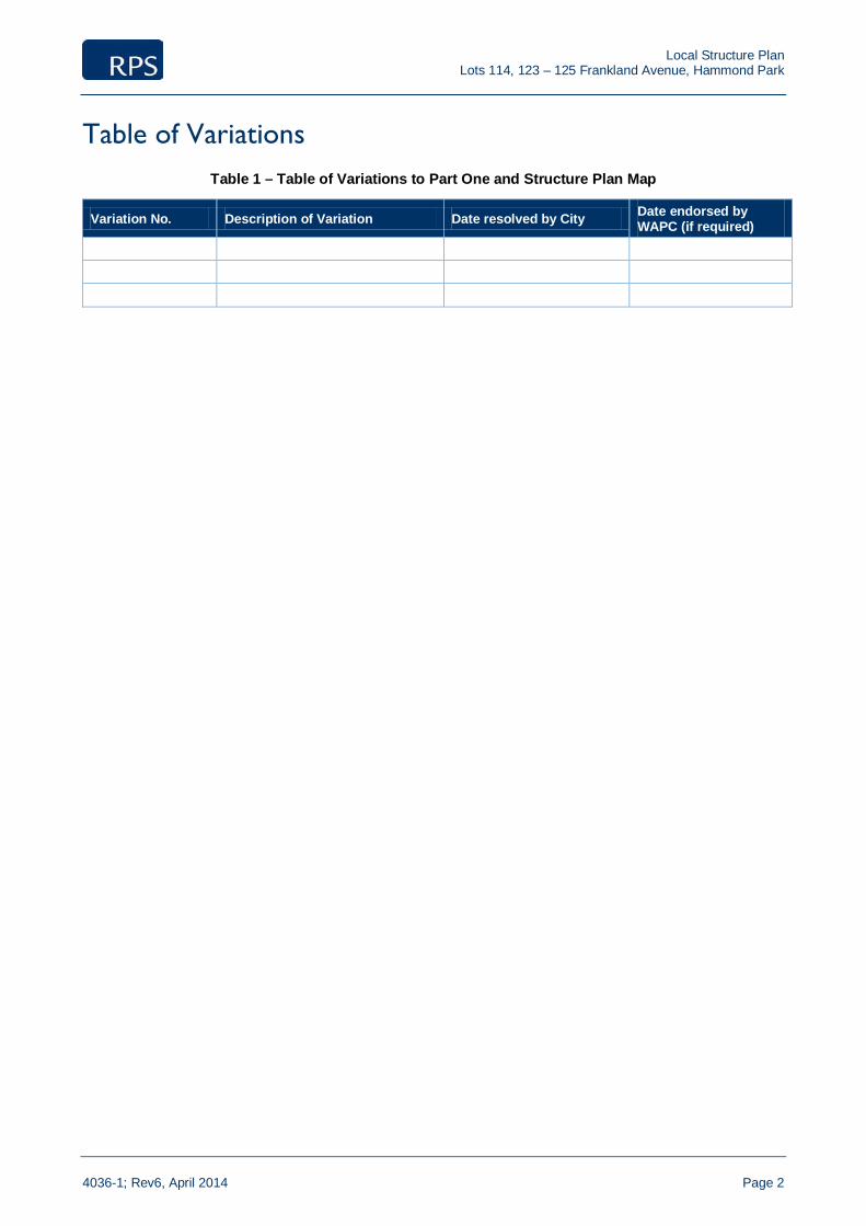
Table of Variations Table 1 – Table of Variations to Part One and Structure Plan Map
Variation No. Description of Variation Date resolved by City Date endorsed by WAPC (if required)
Local Structure Plan Lots 114, 123 – 125 Frankland Avenue, Hammond Park
4036-1; Rev6, April 2014 Page 3
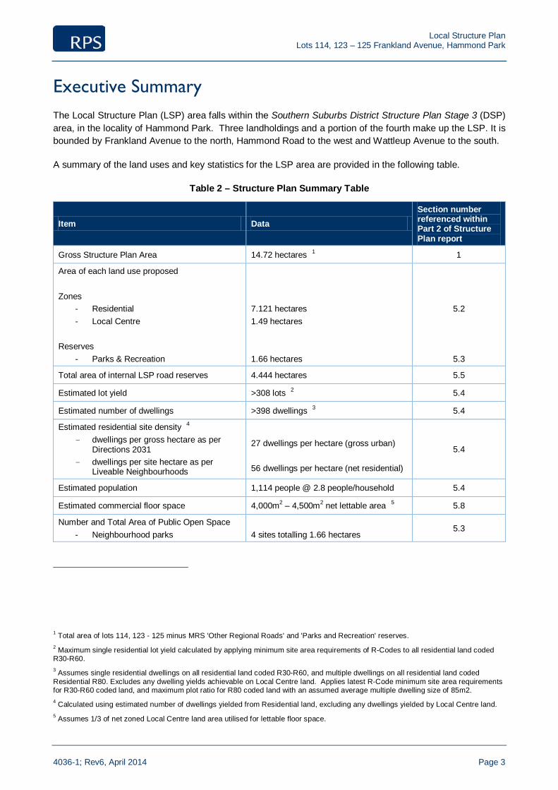
Executive Summary The Local Structure Plan (LSP) area falls within the Southern Suburbs District Structure Plan Stage 3 (DSP) area, in the locality of Hammond Park. Three landholdings and a portion of the fourth make up the LSP. It is bounded by Frankland Avenue to the north, Hammond Road to the west and Wattleup Avenue to the south.
A summary of the land uses and key statistics for the LSP area are provided in the following table.
Table 2 – Structure Plan Summary Table
Item Data Section number referenced within Part 2 of Structure Plan report
Gross Structure Plan Area 14.72 hectares 1 1
Area of each land use proposed Zones
- Residential - Local Centre
Reserves
- Parks & Recreation
7.121 hectares 1.49 hectares 1.66 hectares
5.2
5.3
Total area of internal LSP road reserves 4.444 hectares 5.5
Estimated lot yield >308 lots 2 5.4
Estimated number of dwellings >398 dwellings 3 5.4
Estimated residential site density 4 - dwellings per gross hectare as per
Directions 2031 - dwellings per site hectare as per
Liveable Neighbourhoods
27 dwellings per hectare (gross urban) 56 dwellings per hectare (net residential)
5.4
Estimated population 1,114 people @ 2.8 people/household 5.4
Estimated commercial floor space 4,000m2 – 4,500m2 net lettable area 5 5.8
Number and Total Area of Public Open Space - Neighbourhood parks
4 sites totalling 1.66 hectares
5.3
1 Total area of lots 114, 123 - 125 minus MRS 'Other Regional Roads' and 'Parks and Recreation' reserves. 2 Maximum single residential lot yield calculated by applying minimum site area requirements of R-Codes to all residential land coded R30-R60. 3 Assumes single residential dwellings on all residential land coded R30-R60, and multiple dwellings on all residential land coded Residential R80. Excludes any dwelling yields achievable on Local Centre land. Applies latest R-Code minimum site area requirements for R30-R60 coded land, and maximum plot ratio for R80 coded land with an assumed average multiple dwelling size of 85m2. 4 Calculated using estimated number of dwellings yielded from Residential land, excluding any dwellings yielded by Local Centre land. 5 Assumes 1/3 of net zoned Local Centre land area utilised for lettable floor space.

Local Structure Plan Lots 114, 123 – 125 Frankland Avenue, Hammond Park
4036-1; Rev6, April 2014 Page 4
Pre-lodgement consultation Table 3 – Pre-lodgement Consultation
Agency Date of consultation
Method of consultation
Summary of outcome
City of Cockburn March-May 2013 Draft LSP report provided for preliminary comment
Schedule of comments and recommended edits, along with marked up Structure Plan Map, provided by City of Cockburn. Key issues included:
- Text corrections and minor edits; - Additional information or clarification
required throughout report; - Various design changes aimed at increasing
densities and encouraging greater activity levels in/around identified local centre.
Comments/recommendations addressed and incorporated in LSP report on 29/07/2013 (Rev 2).
Department of Planning
March-April 2013 Draft LSP report provided for preliminary comment (via City of Cockburn)
Schedule of comments and recommended edits, along with marked up Structure Plan Map, provided by City of Cockburn. Key issues included:
- Text corrections and minor edits; - Additional information or clarification
required throughout report; - Various changes/additional information
required in accordance with WAPC Guidelines for Preparation of Structure Plans.
Comments/recommendations addressed and incorporated in report on 29/07/2013 (Rev 2).

Local Structure Plan Lots 114, 123 – 125 Frankland Avenue, Hammond Park
4036-1; Rev6, April 2014 Page 5
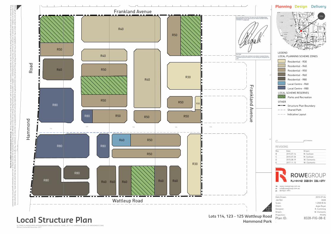
Part One – Statutory Section 1. Structure Plan Area
This Structure Plan applies to Lots 114, 123, 124 and 125 Frankland Avenue, Hammond Park being the land contained within the inner edge of the line denoting the Structure Plan boundary on the Structure Plan Map.
This Structure Plan is identified as the Lots 114, 123-125 Frankland Avenue, Hammond Park Local Structure Plan.
2. Structure Plan Content
This Structure Plan comprises:
a) Part One - Statutory section
This section contains the Structure Plan Map and statutory planning provisions and requirements.
b) Part Two – Non-statutory (explanatory) section
This section to be used as a guide to interpret and justify the implementation of Part One.
c) Appendices – Technical reports and supporting plans and maps.
3. Interpretation and Relationship with the Scheme
Unless otherwise specified in this part, the words and expressions used in this Structure Plan shall have the respective meanings given to them in the City of Cockburn Town Planning Scheme No. 3 as amended.
The Structure Plan Map outlines land use, zones and reserves applicable within the Structure Plan area. The zone and reserve designations under the Structure Plan apply to the land within it as if the zones and reserves were incorporated into the Scheme.
Pursuant to clause 6.2.12.2 of the Scheme, if a provision in the Structure Plan is inconsistent with the Scheme, then the provision of the Scheme prevails to the extent of the inconsistency.
4. Operation
Pursuant to Clause 6.2.12.1(a) of the Scheme, this Structure Plan comes into effect on the day on which it is endorsed by the Western Australian Planning Commission.
5. General Subdivision and Development Requirements
Subdivision and development of the Structure Plan area shall be generally in accordance with the Structure Plan Map.
General standards for subdivision and development include the following:

Local Structure Plan Lots 114, 123 – 125 Frankland Avenue, Hammond Park
4036-1; Rev6, April 2014 Page 6
5.1 Density
The residential densities as prescribed on the Structure Plan Map apply to the Structure Plan area.
5.2 Variations to the Residential Design Codes 2013
This Local Structure Plan amends the following deemed-to-comply provisions(s):
Table 4 – R-Code Variations
Design Element Current Provision Amended deemed-to-comply provision
5.1.4 Open space for the R30 density coding
45% minimum 40% minimum
5.3 Detailed Area Plans
Detailed Area Plans (DAPs) prepared pursuant to clause 6.2.15 of TPS3 are to inform the subdivision and development of the following:
i) Land or lots with rear-loaded (laneway) vehicular access.
ii) Land or lots with direct boundary frontage to an area of public open space.
iii) Land or lots zoned ‘Local Centre’.
iv) Lots within a 100 metre catchment of classified vegetation and deemed at risk from bush fire pursuant to the WAPC and DFES’s Planning for Bush Fire Protection Guidelines (2010) and as identified spatially in the Fire Management Plan – Lots 114, 123-126 Frankland Avenue Hammond Park by Bio Diverse Solutions (as amended).
5.4 Other
This Local Structure Plan is supported by a fire hazard assessment and a Fire Management Plan. Regardless of whether the land has been formally designated as bushfire prone, any buildings to be erected on land identified as falling within 100 metres of a bushfire hazard shall comply with the requirements of Australian Standard 3959 – Construction of Buildings in Bushfire-prone areas under the Building Code of Australia.
Notifications on Title to be placed on lots affected by an increase in construction standards consistent with a bushfire attack level.
123
49
Frankland Avenue
Wattleup Road
46
114
126
48
124125
47
Fra
nk
la
nd
A
ve
nu
e
R40
R50
R40
R50
R50
R50
R50
R40
R30
R50
R50
R50
R30
R60
R60R60
R60
R30
R80R80
R80
R60
R50
R60
R80
R80
R80
Ha
mm
on
d
Ro
ad
R60
R50
Shared Path
LEGEND
LOCAL SCHEME RESERVES
Parks and Recreation
LOCAL PLANNING SCHEME ZONES
OTHER
Structure Plan Boundary
Residential - R30
Residential - R40
Residential - R50
Residential - R60
Residential - R80
Local Centre - R60
Local Centre - R80
Indicative Layout
Alth
ou
gh
a
ll ca
re
h
as b
ee
n ta
ke
n o
n th
e co
mp
ila
tio
n o
f th
is d
ocu
me
nt R
ow
e G
ro
up
a
nd
a
ll p
artie
s a
sso
cia
te
d w
ith
its p
re
pa
ra
tio
n d
iscla
im
a
ny re
sp
on
sib
ility fo
r a
ny e
rro
rs o
r o
missio
ns. T
he
rig
ht is re
se
rve
d to
ch
an
ge
th
is d
ocu
me
nt a
t a
ny tim
e. T
his d
ocu
me
nt d
oe
s
no
t co
nstitu
te
a
n in
vita
tio
n, a
gre
em
en
t o
r co
ntra
ct (o
r a
ny p
art th
ere
of) o
f a
ny k
in
d w
ha
tso
eve
r. L
ia
bility is e
xp
re
ssly d
iscla
im
ed
b
y R
ow
e G
ro
up
fo
r a
ny lo
ss o
r d
am
ag
e w
hich
m
ay b
e su
sta
in
ed
b
y a
ny p
erso
n a
ctin
g o
n a
ny visu
al im
pre
ssio
n g
ain
ed
fro
m th
is d
ocu
me
nt.
Th
is d
ocu
me
nt is a
nd
re
ma
in
s th
e p
ro
pe
rty o
f R
ow
e G
ro
up
a
nd
m
ay n
ot b
e re
pro
du
ce
d o
r tra
nsm
itte
d, in
w
ho
le
o
r in
p
art, w
ith
ou
t th
e w
ritte
n co
nse
nt o
f R
ow
e G
ro
up
. A
ll a
re
as
a
nd
d
im
en
sio
ns
a
re
s
ub
je
ct to
s
urv
ey
.
-
Date Drawn:
Job Ref:
Scale:
Client:
Designer:
Drawn:
Projection:
Plan ID:
REVISIONS
Rev Date Drawn
B 2015.07.14 M. Sullivan
C 2015.07.20 M. Sullivan
D 2015.08.19 W. Clements
E 2017.11.13 W. Clements
w: www.rowegroup.com.au
p: 08 9221 1991
Site
Planning Design Delivery
Local Structure Plan
Lots 114, 123 - 125 Wattleup Road
Hammond Park
@ A4
2015-07-06
8328
1:2500
Aigle Royal
R. Cumming
W. Clements
PCG94
8328-FIG-08-E
N:\TOWN PLANNING\8000-8999\8328\DRAFTING\A-CAD\8328_FIG08E_20171113 HAMMOND PARK (LSP AMENDMENT).DWG
13 November 2017William Clements
0 62.5 Metres
ROWEGROUP
N
8328_17dec01_POS Schedule 1 Created 16/04/18
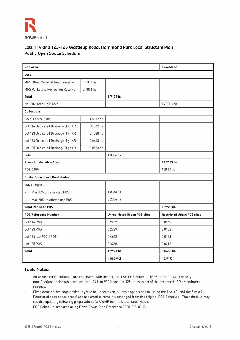
Lots 114 and 123-125 Wattleup Road, Hammond Park Local Structure Plan
Public Open Space Schedule
Site Area 16.4378 ha
Less
MRS Other Regional Road Reserve 1.5374 ha
MRS Parks and Recreation Reserve 0.1801 ha
Total 1.7175 ha
Net Site Area (LSP Area) 14.7203 ha
Deductions
Local Centre Zone 1.5312 ha
Lot 114 Dedicated Drainage (1 yr ARI) 0.072 ha
Lot 123 Dedicated Drainage (1 yr ARI) 0.1028 ha
Lot 124 Dedicated Drainage (1 yr ARI) 0.0413 ha
Lot 125 Dedicated Drainage (1 yr ARI) 0.0533 ha
Total 1.8006 ha
Gross Subdivisible Area 12.9197 ha
POS @10% 1.2920 ha
Public Open Space Contribution
May comprise:
- Min 80% unrestricted POS 1.0336 ha
- Max 20% restricted use POS 0.2584 ha
Total Required POS 1.2920 ha
POS Reference Number Unrestricted Urban POS sites Restricted Urban POS sites
Lot 114 POS 0.2252 0.0167
Lot 123 POS 0.2829 0.0152
Lot 124 (Lot 9001) POS 0.4602 0.0123
Lot 125 POS 0.3288 0.0213
Total 1.2971 ha 0.0655 ha
(10.04%) (0.51%)
Table Notes:
- All areas and calculations are consistent with the original LSP POS Schedule (RPS, April 2014). The only
modifications to the table are for Lots 124 (Lot 9001) and Lot 125, the subject of the proposed LSP amendment
request.
- Given detailed drainage design is yet to be undertaken, all drainage areas (including the 1 yr ARI and the 5 yr ARI
Restricted open space areas) are assumed to remain unchanged from the original POS Schedule. The schedule may
require updating following preparation of a UWMP for the site at subdivision.
- POS Schedule prepared using Rowe Group Plan Reference 8328-FIG-08-E.