Embed Size (px)
Citation preview

Four Ashes Ltd
Transport Assessment Part 1 of 3 - TextWSPThe West Midlands Rail Freight Interchange Order 201XJuly 2017 - DRAFT FOR STAGE 2 CONSULTATION

West Midlands Interchange Transport Assessment Page 1 Draft for Stage Two Consultation
The West Midlands Rail Freight Interchange Order 201x
Draft Transport Assessment
July 2017
WSP
Revision Date Author
Draft for Stage Two Consultation
23 June 2017 WSP
West Midlands Interchange Transport Assessment Page 2 Draft for Stage Two Consultation
Contents
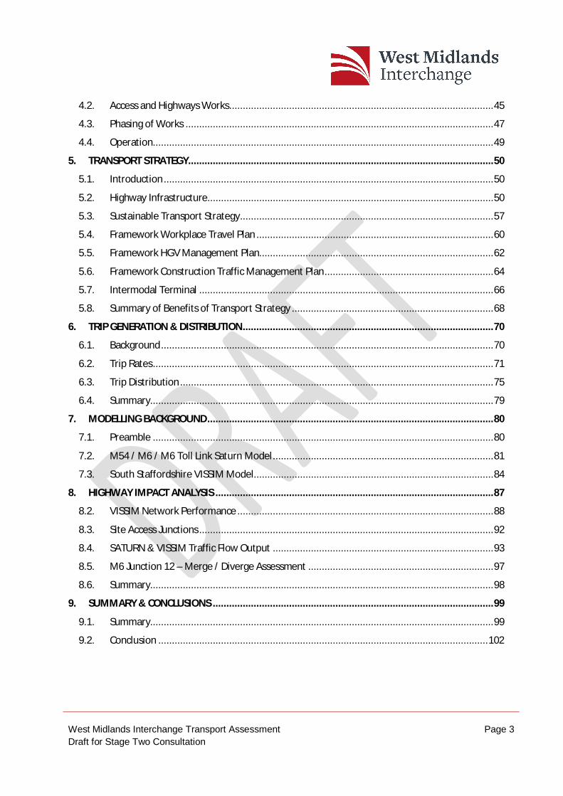
GLOSSARY ............................................................................................................................................. 7
EXECUTIVE SUMMARY .......................................................................................................................... 9
1. INTRODUCTION ........................................................................................................................... 12
1.1. Preamble ............................................................................................................................. 12
1.2. Background .......................................................................................................................... 13
1.3. Stakeholder Consultation ..................................................................................................... 13
1.4. Stage 1 Consultation ............................................................................................................ 14
1.5. Report Structure .................................................................................................................. 14
2. PLANNING POLICY REVIEW.......................................................................................................... 16
2.1. Preamble ............................................................................................................................. 16
2.2. National Planning ................................................................................................................. 16
2.3. Regional Policy - Transport ................................................................................................... 20
2.4. Regional Policy – Economic Growth ...................................................................................... 21
2.5. Black Country and Southern Staffordshire Regional Logistics Site Study (URS, 2013) ............ 22
2.6. Local Policy .......................................................................................................................... 22
2.7. Policy Summary .................................................................................................................... 23
3. SITE LOCATION AND EXISTING CONDITIONS ............................................................................... 24
3.1. Preamble ............................................................................................................................. 24
3.2. Site Location & Existing Use ................................................................................................. 24
3.3. Highway Network ................................................................................................................. 25
3.4. Pedestrian and Cycle Network .............................................................................................. 27
3.5. Public Transport Network ..................................................................................................... 29
3.6. Accessibility to Local Facilities .............................................................................................. 33
3.7. Baseline Traffic Flows ........................................................................................................... 34
3.8. Personal Injury Accident Data............................................................................................... 38
3.9. Summary.............................................................................................................................. 42
4. DEVELOPMENT PROPOSALS ........................................................................................................ 43
4.1. Introduction ......................................................................................................................... 43
West Midlands Interchange Transport Assessment Page 3 Draft for Stage Two Consultation
4.2. Access and Highways Works ................................................................................................. 45
4.3. Phasing of Works ................................................................................................................. 47
4.4. Operation............................................................................................................................. 49
5. TRANSPORT STRATEGY ................................................................................................................ 50
5.1. Introduction ......................................................................................................................... 50
5.2. Highway Infrastructure......................................................................................................... 50
5.3. Sustainable Transport Strategy ............................................................................................. 57
5.4. Framework Workplace Travel Plan ....................................................................................... 60
5.5. Framework HGV Management Plan...................................................................................... 62
5.6. Framework Construction Traffic Management Plan .............................................................. 64
5.7. Intermodal Terminal ............................................................................................................ 66
5.8. Summary of Benefits of Transport Strategy .......................................................................... 68
6. TRIP GENERATION & DISTRIBUTION ............................................................................................ 70
6.1. Background .......................................................................................................................... 70
6.2. Trip Rates ............................................................................................................................. 71
6.3. Trip Distribution ................................................................................................................... 75
6.4. Summary.............................................................................................................................. 79
7. MODELLING BACKGROUND ......................................................................................................... 80
7.1. Preamble ............................................................................................................................. 80
7.2. M54 / M6 / M6 Toll Link Saturn Model ................................................................................. 81
7.3. South Staffordshire VISSIM Model........................................................................................ 84
8. HIGHWAY IMPACT ANALYSIS ...................................................................................................... 87
8.2. VISSIM Network Performance .............................................................................................. 88
8.3. Site Access Junctions ............................................................................................................ 92
8.4. SATURN & VISSIM Traffic Flow Output ................................................................................. 93
8.5. M6 Junction 12 – Merge / Diverge Assessment .................................................................... 97
8.6. Summary.............................................................................................................................. 98
9. SUMMARY & CONCLUSIONS ....................................................................................................... 99
9.1. Summary.............................................................................................................................. 99
9.2. Conclusion ......................................................................................................................... 102

West Midlands Interchange Transport Assessment Page 4 Draft for Stage Two Consultation
Figures
1 - Site Location and Local Highway Network
2- Existing Pedestrian and Cycle Network
3 - Existing Public Transport Network
4 - Survey Locations
5 - Personal Injury Accidents 1/7/11 to 30/6/16
6 - Access Points to Site
7 - Proposed Non Car Access Strategy
8 - Key Junction Locations
Tables
Table 1: Bus Services Available from the A449 Stops in the Vicinity of Gravelly Way
Table 2: Summary of National Rail Services to Penkridge Railway Station
Table 3: Summary of National Rail Services to Cannock Railway Station
Table 4: Summary of National Rail Services to Wolverhampton Railway Station
Table 5: Local Facilities Under 2 miles from Site
Table 6: 2015 Baseline Traffic Flows on A5 (Vehicles per Hour)
Table 7: 2015 Baseline Traffic Flows on A449 (Vehicles per Hour)
Table 8: 2015 Baseline Traffic Flows on Roads South of WMI Site (Vehicles per Hour)
Table 9: 2015 Highway Link Capacity Assessments
Table 10: Personal Injury Accident Data at Junctions
Table 11: Personal Injury Accident Data on Links
Table 12: External Light Vehicle Trip Rates at DIRFT (Per 100sqm)
Table 13: Number of External Light Vehicle Trips at WMI
Table 14: Base Travel to Work Mode Share at WMI
Table 15: External Non – HGV Multi Modal Person Trip Rates (per 100sqm)
West Midlands Interchange Transport Assessment Page 5 Draft for Stage Two Consultation
Table 16: External Warehouse Related Heavy Good Vehicle Trip Rates at DIRFT (per 100sqm)
Table 17: External Warehouse Related Heavy Good Vehicle Trips at WMI
Table 18: External Intermodal Related Heavy Goods Vehicle Trips
Table 19: Total External Heavy Good Vehicle Trips
Table 20: Light Vehicle (Employee) Distribution – Gravity Model
Table 21: National HGV Two Way Distribution
Table 22: HGV Distribution Within West Midlands
Table 23: Journey Time Comparisons of 2021 Without WMI and 2021 With WMI
Table 24: Summary of Difference in Average Vehicle Queue Length 2021 Without WMI - 2021 With WMI
Table 25: Comparison of Two Way Link Flows
Table 26: Directional Link Flows for 2021 Without WMI and 2021 With WMI
Table 27: Without WMI – M6 Junction 12 Flows
Table 28: 2021 With WMI – M6 Junction 12 Flows
Table 29: 2021 Merge/Diverge Requirements for M6 Junction 12
Diagrams
Diagram 7.1 Extent of M54/M6/M6 Toll Link SATURN Model
Diagram 7.2: Extent of South Staffordshire VISSIM Model
Appendices
A - Transport Assessment Scoping Note
B - Meeting Notes
C - List of Surveys Undertaken
D - 2015 Baseline Link Flow Diagram
E - Site Masterplan
F - General Arrangement Drawings
West Midlands Interchange Transport Assessment Page 6 Draft for Stage Two Consultation
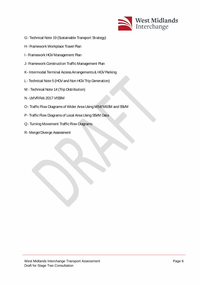
G - Technical Note 19 (Sustainable Transport Strategy)
H - Framework Workplace Travel Plan
I - Framework HGV Management Plan
J - Framework Construction Traffic Management Plan
K - Intermodal Terminal Access Arrangements & HGV Parking
L - Technical Note 5 (HGV and Non HGV Trip Generation)
M - Technical Note 14 (Trip Distribution)
N - LMVR Feb 2017 VISSIM
O - Traffic Flow Diagrams of Wider Area Using M54/M6SM and SSVM
P - Traffic Flow Diagrams of Local Area Using SSVM Data
Q - Turning Movement Traffic Flow Diagrams
R - Merge/Diverge Assessment
West Midlands Interchange Transport Assessment Page 7 Draft for Stage Two Consultation
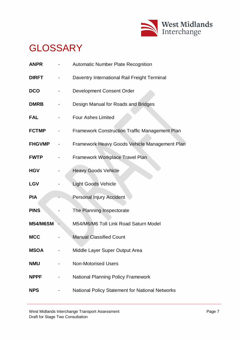
GLOSSARY ANPR - Automatic Number Plate Recognition
DIRFT - Daventry International Rail Freight Terminal
DCO - Development Consent Order
DMRB - Design Manual for Roads and Bridges
FAL - Four Ashes Limited
FCTMP - Framework Construction Traffic Management Plan
FHGVMP - Framework Heavy Goods Vehicle Management Plan
FWTP - Framework Workplace Travel Plan
HGV - Heavy Goods Vehicle
LGV - Light Goods Vehicle
PIA - Personal Injury Accident
PINS - The Planning Inspectorate
M54/M6SM - M54/M6/M6 Toll Link Road Saturn Model
MCC - Manual Classified Count
MSOA - Middle Layer Super Output Area
NMU - Non-Motorised Users
NPPF - National Planning Policy Framework
NPS - National Policy Statement for National Networks
West Midlands Interchange Transport Assessment Page 8 Draft for Stage Two Consultation
NSIP - Nationally Significant Infrastructure Project
RFI - Rail Freight Interchange
SATURN - Simulation and Assignment of Traffic to Urban Roads
SCC - Staffordshire County Council
SRN - Strategic Road Network
SRFI - Strategic Rail Freight Interchange
SSDC - South Staffordshire District Council
SSVM - South Staffordshire VISSIM Model
UAP - Urban All-Purpose Road
VISSIM - Verkehr In Städten – SIMulationsmodell
(Traffic micro-simulation modelling program)
WCML - West Coast Main Line
WMI - West Midlands Interchange

West Midlands Interchange Transport Assessment Page 9 Draft for Stage Two Consultation
EXECUTIVE SUMMARY This draft Transport Assessment (TA) has been prepared on behalf of Four Ashes Limited in support of the Development Consent Order (DCO) for the development of a new Strategic Rail Freight Interchange (SRFI) at land located at Four Ashes, Staffordshire (the Site). The Site is located south west of the M6 Junction 12 and is bordered by the A5 to the north of the Site and the A449 to the west of the Site.
The Proposed Development comprises:
An intermodal rail freight terminal with connections to the West Coast Main Line, capable of accommodating up to 10 trains per day and trains of up to 775m long and including container storage, HGV parking, rail control building and staff facilities;
Up to 743,200 square metres of rail served warehousing and ancillary service buildings;
New road infrastructure and works to the existing road infrastructure;
Demolition of existing structures and structural earthworks to create development plots and landscape zones;
Repositioning and burying of electricity pylons and cables; and
Strategic landscaping and open space, including alterations to public rights of way and the creation of new ecological enhancement areas and publicly accessible open areas.
The SRFI will operate 24 hours a day 7 days a week. Vehicle movements to the Site will be a mixture of Heavy Good Vehicles (HGVs), employee vehicles or visitors.
This TA has considered the relevant national, regional and local transport policies relevant to the Proposed Development and the production of this report.
The Proposed Development trip generation has been derived using trip rates based on surveys at Daventry International Rail Freight Terminal (DIRFT), a similar facility near M1 Junction 18. This methodology and the results have been agreed with the
West Midlands Interchange Transport Assessment Page 10 Draft for Stage Two Consultation
highway authorities along with the Proposed Development trip distribution for both employees and Heavy Goods Vehicles.
There are a number of highway works proposed to serve the scheme and provide improvements for existing road users. These aspects of the strategy will ensure that appropriate access is provided for WMI traffic, ensure that the proposed development does not have an adverse impact upon the existing transport network and also provide improvements for some existing road users.
In order to facilitate highway access to WMI, it is proposed to;
construct a new roundabout on the A5, providing access to the Site;
construct a new roundabout on the A449, providing access to the Site;
construct a new adopted road connecting the A5 and A449 between these two new junctions;
construct a new roundabout on Vicarage Road, providing access to the Site;
There will be a number of other improvements to the local highway network and these are:
alterations to the junction layout at the A449 / Station Drive junction to enable a banned right turn.
alterations to the layout of Crateford Lane to make it one-way in a west to east direction; and
the construction of an HGV turning area on Station Drive, before the low WCML bridge.
To promote sustainable travel principles to the Site, a Framework Workplace Travel Plan and Sustainable Transport Strategy have also been developed and are appended to the TA. Measures included in these documents include suggested new and expanded bus services, new and improved footway / cycleways on roads
West Midlands Interchange Transport Assessment Page 11 Draft for Stage Two Consultation
surrounding the Site and initiatives to reduce single occupancy car travel such as personalised travel planning, dedicated travel website and a car sharing portal.
A Framework HGV Management Plan and Framework Construction Traffic Management Plan have also been produced in order to reduce the impact of HGV’s upon the local highway network. This will include the banning of WMI HGV’s through Penkridge (apart from those vehicles with specific business in the town), which will be enforced by a monitoring regime.
Future traffic forecasts have been derived from the M54 / M6 link Road SATURN Model (M54/M6SM) and the South Staffordshire VISSIM Model (SSVM). The M54/M6SM covers a large area extending from Stafford in the north to Birmingham in the south. The SSVM covers a smaller area in more detail, extending from north on M6 Junction 12 to south of the M54. The M54/M6SM has been used to provide the growth assumptions for the SSVM together with the distribution of traffic to the wider highway network whilst the assessment of the development impact is based on the outputs of the SSVM, as agreed with the highway authorities.
Journey times, traffic flows and queue lengths have all been extracted from the SSVM in order to review the performance of the highway network with the Proposed Development. This data has demonstrated that, with the addition of the proposed highway mitigation measures, the performance of roads around the Site does not deteriorate when compared to the scenario without WMI. In particular, the road connecting the A5 and A449 roundabouts will provide an alternative route for both existing road users and WMI traffic which will allow them to bypass the Gailey Roundabout. It will be available for use by public traffic at all times and would be a signed route between M6 Junction 12 and the A449. This choice of route means that in the future there will be added resilience to this area, whereby vehicles can vary their route as necessary.
Overall this TA demonstrates that, with the introduction of specific and tailored highway improvements, the highway network can accommodate the additional traffic associated with the Proposed WMI Development. Any impact will be further reduced by the implementation of a robust and specific Travel Plan.
West Midlands Interchange Transport Assessment Page 12 Draft for Stage Two Consultation
1. INTRODUCTION 1.1. Preamble
1.1.1. WSP has been appointed by Four Ashes Limited (FAL) to provide transport advice and prepare a draft Transport Assessment (TA) to be submitted with the Development Consent Order (DCO) application for a Strategic Rail Freight Interchange (SRFI) known as the West Midlands Interchange (WMI) in South Staffordshire.
1.1.2. The Site is located approximately 10km north of Wolverhampton and lies immediately west of Junction 12 of the M6. The West Coast Main Line (WCML) railway runs through the Site. It has a strategically significant location on both the national road and rail networks.
1.1.3. The Site is within the administrative boundary of South Staffordshire District Council (SSDC) and the local highway authority is Staffordshire County Council (SCC). The application Site is bordered by the M6, A5 and A449 which are part of the strategic road network and under the jurisdiction of Highways England (HE).
1.1.4. The WMI would be linked directly to the WCML, one of the country’s principal freight routes, and will be well placed to serve the West Midlands region.
1.1.5. WMI will include a multi-modal rail freight interchange and distribution centre linked to both the rail and road network. The intermodal terminal will provide the interchange between road and rail for freight and goods and will be accessible to all businesses. Such facilities serve both local and national market places and, as a consequence, there is a need for these facilities to be located in proximity to the trunk road and motorway network for onward distribution of goods.
1.1.6. WMI will provide for up to 743,200 square metres (sqm) of new rail-served warehousing, which will provide an opportune destination for the region’s important logistics industry to grow.
1.1.7. The National Policy Statement for National Networks (NPS) provides the primary policy basis for the consideration of SRFI.
West Midlands Interchange Transport Assessment Page 13 Draft for Stage Two Consultation
1.1.8. WMI falls within the definition of a Nationally Significant Infrastructure Project (NSIP) as defined within the NPS. Therefore, the applicant intends to make an application to the Secretary of State (SoS) via the Planning Inspectorate (PINS) for a DCO under the Planning Act 2008 (‘the Act’)
1.2. Background
1.2.1. This TA considers transportation issues and strategy in relation to the Proposed Development and has been prepared as a supporting document as part of the Stage Two Consultation on the Proposed Development.
1.2.2. This TA has been produced in accordance with the Planning Practice Guidance (PPG) (DCLG March 2014) entitled ‘Overarching Principle on Travel Plans, Transport Assessments and Statements’ which sets out the parameters for such reports.
1.2.3. This report has been produced to assess the Proposed Development in terms of transport impact, accessibility and policy compliance. In addition, a Framework Heavy Goods Vehicle Management Plan (FHGVMP), Framework Construction Transport Management Plan (FCTMP), and Framework Workplace Travel Plan (FWTP) have been produced as separate documents and are appended to the draft TA.
1.2.4. This Assessment does not include any detailed analysis of the rail network and use for rail freight. For further details please refer to the Rail Operations Report.
1.3. Stakeholder Consultation
1.3.1. A meeting was held in April 2016 between WSP, SCC and HE, to discuss transport matters in relation to WMI. Subsequently a TA Scoping Note was prepared in June 2016 and agreed by all parties. This is included in Appendix A.
West Midlands Interchange Transport Assessment Page 14 Draft for Stage Two Consultation
1.3.2. Throughout the process leading to Stage Two Consultation, dialogue has been undertaken with the following authorities in order to discuss transport matters:
Highways England;
Staffordshire County Council;
South Staffordshire District Council; and
Wolverhampton City Council.
1.3.3. Copies of the minutes of the meetings held with these stakeholders are provided at Appendix B.
1.4. Stage 1 Consultation
1.4.1. As part of this DCO application, “non-statutory’ consultation (Stage One) was carried out between 13 June and 24 July 2016.
1.4.2. The comments received during the Stage One Consultation were recorded, analysed and used to inform the evolution of the WMI project.
1.5. Report Structure
1.5.1. The remainder of the TA is presented in the following sections:
Section 2 provides an overview of national and local policy;
Section 3 details existing conditions and accessibility;
Section 4 sets out details of the Proposed Development and access strategy;
Section 5 sets out the proposed transport strategy that will serve the Proposed Development proposals;
West Midlands Interchange Transport Assessment Page 15 Draft for Stage Two Consultation
Section 6 sets out the trip characteristics for the development, including trip generation, modal split and distribution onto the local highway network;
Section 7 outlines the traffic modelling process and provides background to the models used to assess the impact of the development;
Section 8 provides a summary of the traffic model impact analysis and justifies the mitigation strategy proposed; and
Section 9 summarises and concludes this Transport Assessment.
West Midlands Interchange Transport Assessment Page 16 Draft for Stage Two Consultation
2. PLANNING POLICY REVIEW 2.1. Preamble
2.1.1. This section sets out an overview of the national, regional and local transport policy to provide context for the assessment of the development proposals.
2.2. National Planning
National Policy Statement for National Networks (December 2014)
2.2.1. The document sets out the need for, and Government policies to deliver, development of NSIPs on the national road and rail networks in England.
2.2.2. Section two of the document sets out the Government’s vision and strategic objectives for the national networks:
‘The Government will deliver national networks that meet the country’s long term needs; supporting a prosperous and competitive economy and improving overall quality of life, as part of a wider transport system.’
2.2.3. Paragraph 2.29 summarises the ‘must haves’ for railway developments and summarises the requirement to ‘provide for the transport of freight across the country, and to and from ports, in order to help meet environmental goals and improve quality of life.’
2.2.4. The NPS sets out the need for the development of SRFI in paragraphs 2.42 – 2.45 of the NPS. The NPS highlights that SRFI’s can be a key element in reducing the cost to users of moving freight by rail and are important in facilitating the transfer of freight from road to rail.
2.2.5. Paragraph 2.54 outlines the need for a network of SRFIs across the regions, to serve regional, sub-regional and cross regional markets to facilitate modal shift. Furthermore paragraph 2.54 states ‘In all cases it is essential that these have good connectivity with both the road and rail networks’.
West Midlands Interchange Transport Assessment Page 17 Draft for Stage Two Consultation
2.2.6. Paragraph 2.56 states the Government has concluded that there is a compelling need for an expanded network of SRFIs. It is important that SRFIs are located near the business markets they will serve – major urban centres, or groups of centres – and are linked to key supply chain routes.
2.2.7. Paragraph 3.17 stresses the importance of accommodating pedestrians and cyclists; noting “there is a direct role for the national road network to play in helping pedestrians and cyclists. The Government expects applicants to use reasonable endeavours to address the needs of cyclists and pedestrians in the design of new schemes. The Government also expects applicants to identify opportunities to invest in infrastructure in locations where the national road network severs communities and acts as a barrier to cycling and walking, by correcting historic problems, retrofitting the latest solutions and ensuring that it is easy and safe for cyclists to use junctions”.
2.2.8. Section 5 of the NPSNN discusses the impacts on transport networks, specifically it notes for SRFI developments ‘it should include a Transport Assessment, using the WebTAG methodology stipulated in Department for Transport guidance, or successor to such methodology. If a development is subject to EIA and is likely to have significant environmental impacts arising from impacts on transport networks, the applicant’s environmental statement should describe those impacts.’…… ‘the applicant should prepare a travel plan including management measures to mitigate transport impacts. The applicant should also provide details of proposed measures to improve access by public transport and sustainable modes where relevant, to reduce the need for any parking associated with the proposal and to mitigate transport impacts’.
National Planning Policy Framework, DCLG, March 2012
2.2.9. The National Planning Policy Framework (NPPF) was published in March 2012 and replaced all PPGs and PPSs relating to Transport.
2.2.10. The NPPF introduces a presumption in favour of sustainable development, summarised in paragraph 14 of the document as follows “At the heart of the National Planning Policy Framework is a presumption in favour of sustainable development, which should be seen as a golden thread running through both plan-making and decision-taking.”
West Midlands Interchange Transport Assessment Page 18 Draft for Stage Two Consultation
2.2.11. The objectives in relation to transport policy are:
“facilitating sustainable development but also in contributing to wider sustainability and health objectives” (Paragraph 29);
“Support reductions in greenhouse gas emissions and reduce congestion. In preparing Local Plans, local planning authorities should therefore support a pattern of development which, where reasonable to do so, facilitates the use of sustainable modes of transport” (Paragraph 30);and
“Develop strategies for the provision of viable infrastructure necessary to support sustainable development” (Paragraph 31).
2.2.12. The framework provides guidance on the key transport issues which should be considered through the planning process for developments that generate significant amounts of movements. It states that plans and decisions should consider:
“That opportunities for sustainable transport modes have been taken up depending on the nature and location of the Site, to reduce the need for major transport infrastructure, and that safe and suitable access to the Site can be achieved for all people; and
Paragraph 32 states that “improvements can be undertaken within the transport network that costs effectively limit the significant impacts of the development. Development should not be prevented or refused on transport grounds where the residual impacts of development are severe” (Paragraph 32).
2.2.13. Paragraph 36 discusses that a travel plan would be a key tool to facilitate a shift in sustainable travel modes to the Site; and that “All developments which generate significant amounts of movement should be required to provide a Travel Plan.”
West Midlands Interchange Transport Assessment Page 19 Draft for Stage Two Consultation
DFT Circular 02/2013, The Strategic Road Network and the Delivery of Sustainable Development
2.2.14. This document provides details of how HE will engage with communities and the development industry to deliver sustainable development and, thus, economic growth, whilst safeguarding the primary function and purpose of the strategic road network.
2.2.15. The document reflects the Policy stance of the NPPF of a presumption in favour of development where at paragraph 9 it states:- “Development proposals are likely to be accepted if they can be accommodated within the existing capacity of a section (link or junction) of the strategic road network, or they do not increase demand for use of a section that is already operating at over-capacity levels, taking account of any travel plan, traffic management and/or capacity enhancement measures that may be agreed. However, development should only be prevented or refused on transport grounds where the residual cumulative impacts of development are severe”.
2.2.16. Paragraph 48 goes on to state that any Transport Assessment undertaken by the promoter of the development should be comprehensive enough to establish the likely environmental impacts, including air quality, light pollution and noise, and to identify the measures to mitigate these impacts.
Creating Growth, Cutting Carbon: Making Sustainable Transport Happen (DFT, 2011)
2.2.17. Creating Growth, Cutting Carbon is the DfT White Paper published in January 2011, which sets out plans for transport to become an engine to economic growth through careful investment in sustainable transport. Its key aim is to:
2.2.18. Encourage sustainable local travel and economic growth by making public transport, cycling and walking more attractive and effective, promoting lower carbon transport and tackling local road congestion.
West Midlands Interchange Transport Assessment Page 20 Draft for Stage Two Consultation
2.2.19. The document aims to encourage more sustainable transport choices through returning decision making to the local level where they know what works. It realises that for some journeys, the car is the only viable mode and therefore, low emission vehicles are important in addressing that demand, together with car sharing and car-pooling opportunities.
The Logistics Growth Review – Connecting People with Goods, DFT Circular, November 2011
2.2.20. The document outlines five core areas in which Government can play a significant part in increasing productivity of the UK industry and strengthening its role in the UK economy:
Giving industry greater confidence to invest;
Improving the longer term capacity, performing and resilience of our congestion road and rail networks;
Promoting the image of the sector at local level;
Reduce unnecessary regulation; and
Attracting and retaining high calibre recruits.
2.3. Regional Policy - Transport
Movement for Growth: The West Midlands Strategic Transport Plan, December 2015
2.3.1. Section 3.1 of the document sets out the vision for transport:
‘We will make great progress for a Midlands economic ‘Engine for Growth’, clean air, improved heath and quality of life for the people of the West Midlands. We will do this by creating a transport system befitting a sustainable, attractive conurbation in the world’s sixth largest economy.’
West Midlands Interchange Transport Assessment Page 21 Draft for Stage Two Consultation
2.3.2. The document sets out aims to improve transport connectivity and reduce the environmental impact on the environment including reducing carbon emissions and improving air quality, through making better use of the transport capacity and through providing new capacity for road and rail freight. Three key policies include:
Policy 1 To use existing transport capacity more effectively to provide greater reliability and average speed for the movement of people and goods.
Policy 3 To improve connections to new economic development locations to help them flourish and
Policy 5 To accommodate increased travel demand by existing transport capacity and new sustainable transport capacity.
2.4. Regional Policy – Economic Growth
West Midlands Metropolitan Freight Strategy 2030, Supporting our Economy: Tackling Carbon (April 2013)
2.4.1. This document aspires to deliver investment in freight to meet the following vision ‘“By 2030, the Metropolitan Area will have safer, more reliable and efficient freight and logistics movements to, from and within the West Midlands, which support sustainable economic growth by enhancing our trade links, boosts productivity, addresses carbon emissions and attracts investment into the Metropolitan Area”.
2.4.2. To meet this target a number of key objectives have been set out which include supporting sustainable economic growth (Key Objective 1) “by improving productivity and competitiveness through reduced costs for businesses and freight operators; enhancing market access and; attracting new companies and industrial sectors to relocate here, creating new jobs and economic growth”. In addition to Reducing Carbon Emissions (Key 0bjective 2) “through shorter, more reliable journeys whilst also promoting and encouraging greater use of low carbon modes of freight.”
West Midlands Interchange Transport Assessment Page 22 Draft for Stage Two Consultation
2.4.3. Support for the SRFI is promoted within this document and paragraph 9.25 states ‘Without SRFI, businesses are forced to make longer distance deliveries to their stores from other distribution centres. This leads to cost, congestion, carbon and air quality impacts”
2.5. Black Country and Southern Staffordshire Regional Logistics Site Study (URS, 2013)
2.5.1. In June 2012, a number of local authorities in the Black Country and Staffordshire commissioned URS Infrastructure and Environment UK Ltd to consider the need for regional logistics provision, or a Regional Logistics Site (RLS), to serve the Black Country and southern Staffordshire and, based on the findings, make recommendations for a suitable location.
2.5.2. The study identifies that the Midlands continues to remain one of the most strategic and efficient locations in the country for major distribution occupiers and developers remain active, although they are frustrated by the lack of suitable land supply and the time to secure planning consent.
2.5.3. The study identifies that, broadly speaking, the transportation impacts of an RLS can be divided into two:
Wider area impacts due to the modal shift of goods being transported from the major ports to the West Midlands by rail; and
Localised impacts between the RLS and the Strategic Route Network (SRN) and other main routes for onward delivery.
2.6. Local Policy
Staffordshire Local Transport Plan, Staffordshire County Council, 2011
2.6.1. This document sets how economic growth and regeneration in the area will be promoted through ensuring efficiency of transport networks in contributing to the attractiveness and vibrancy of towns and villages and supporting schemes that “add value” to the transport network particularly those that promote its “place” route.
West Midlands Interchange Transport Assessment Page 23 Draft for Stage Two Consultation
2.6.2. Policy 1.8 states “We will improve the efficiency of Freight Distribution and sets out that this will be achieved through the actions set out in the Staffordshire Freight Strategy”.
2.6.3. Policy 5.1 includes “Supporting new development that includes or is located in areas with good public transport links, well-connected to walking and cycling networks and facilities, and where the demand for ‘place’ and ‘movement’ is considered together”.
2.6.4. In addition to “Working with local planning authorities and developers to mitigate impacts of development in less sustainable locations but which is essential to support regeneration and economic growth”.
Site Allocations Document (SAD) ‘Preferred Options’ Consultation, South Staffordshire Council (December 2015)
2.6.5. This document specifically discusses employment land within the Four Ashes and states “Our strategic approach is that any identified employment need will largely be met by developing land within the boundaries of the district’s four freestanding Strategic Employment Sites, or as modest extensions to these sites, where justified by robust evidence”.
2.7. Policy Summary
2.7.1. As a key national infrastructure project there are a number of policy documents which set out the need for an SRFI.
2.7.2. In the national interests, the sustainable principles of the Site to remove freight transport from road to rail underpin the development, which will improve the resilience of the road and rail network for future years.
2.7.3. WMI will provide key economic growth for the area and employees at the Site will be encouraged to travel to the Site through the sustainable travel principles underpinned in national policies, which will be used to form the basis for undertaking this Transport Assessment.
2.7.4. The development proposals will be in full accordance with the relevant policy frameworks at a national and local level.
West Midlands Interchange Transport Assessment Page 24 Draft for Stage Two Consultation
3. SITE LOCATION AND EXISTING CONDITIONS
3.1. Preamble
3.1.1. This section outlines the existing transport conditions in the vicinity of the Site, including the strategic and local highway network as well as opportunities for walking, cycling, and public transport, which will facilitate sustainable access to the Site.
3.2. Site Location & Existing Use
3.2.1. WMI is strategically located at an intersection of the Strategic Rail Network (the West Coast Main Line, Western Branch) and the Strategic Road Network (M6, A5 and A449). Such a location makes the Site ideal for national distribution by road and rail though offering all the core requirements for an SRFI. The WMI Site is approximately 297 hectares in size. A detailed description of the Site is provided within the draft Planning Statement prepared by Quod [Document Ref 7.1].
3.2.2. The Site is bounded on its eastern side by the M6, and is broadly bound by the A5 to the north of the Site and the A449 to the west of the Site; these trunk roads provide close connections with the M6 Toll, the M54 and other major trunk roads.
3.2.3. Local roads including Woodlands Lane are situated to the south east of the Site, whilst Station Drive is located to the south. The south-eastern area of the Site is bisected by Vicarage Road, which connects the A449 with the A5 (to the east of M6 Junction 12). Further to the south, Straight Mile passes through the Site.
3.2.4. The Site is currently used as arable farmland. In addition to the farmland a large section of the north eastern part of the Site, known as Calf Heath Quarry is used for sand and gravel mineral extraction.
3.2.5. The location of the Site in relation to the highway network is shown in Figure 1.
West Midlands Interchange Transport Assessment Page 25 Draft for Stage Two Consultation
3.3. Highway Network
M6 Motorway
3.3.1. M6 Junction 12 is located to the east of the Site and is a large conventional grade separated roundabout with four approach arms and no traffic signals. The M6 provides a strategic route which connects both the north and south of England
3.3.2. To the north the M6 provides a strategic route towards Stafford and onto Stoke-on-Trent and Newcastle-under-Lyme before reaching the M56 at Junction 20 and the M62 at Junction 21A which provide an east west route towards Liverpool and Manchester and onto Leeds. Progressing north the M6 passes Preston, Lancaster, Kendal and onto Carlisle. To the south the M6 provides links with Walsall at M6 junction 10 and Birmingham via the A38(M) enabling a direct route into Birmingham city centre. The M6 also provides a connection to Coventry at junction 3 before merging with the A41 and M1 Junction 19.
M6 Toll Motorway
3.3.3. The M6 Toll is situated approximately 3.2km south of M6 Junction 12 and provides a 27 mile route towards M6 Junction 3a to the east of Birmingham. The toll road provides an alternative route through the Midlands which bypasses areas of the M6 which pass though Birmingham and Walsall. The M6 Toll follows a route to the east of Birmingham, Walsall, Sutton Coldfield and Wolverhampton while passing the south of Cannock where it merges with the M6 to the east of the WMI Site at Junction 11a. The M6 Toll and the A5 provide a strategic route to the East Midlands Airport which is located 47 miles to the east of the Site and also to Birmingham International Airport which is 31 miles to the south east of WMI.
A5
3.3.4. The A5 runs on an east to west alignment along the northern border of the Site and forms part of the Strategic Road Network (SRN) from London, England and North Wales with Highways England (HE) as the relevant highway authority. The section of A5 to the north of the Site consists of a single carriageway road with a carriageway width of approximately 10m and is subject to a 50mph speed limit enforced by cameras.
West Midlands Interchange Transport Assessment Page 26 Draft for Stage Two Consultation
3.3.5. The section of A5 bordering the north of the Site has a number of residential dwellings and other properties with direct frontage access distributed on both the northern and southern sides of the carriageway. Access is also provided to the Calf Heath Quarry and Avenue Cottages via a left in / left out junction.
3.3.6. To the west of the Site the A5 facilitates routes towards the A449 via a priority controlled roundabout junction known locally as the Gailey Roundabout while continuing west towards the A41 and Telford. Gailey Roundabout has development on three corners with individual accesses near the junction itself.
3.3.7. To the east of the Site the A5 provides a connection to M6 Junction 12. Continuing east, the A5 passes Four Cross where the Truckers Rest Café is located and progresses into Cannock. At this point the A5 provides further connection to the M6 Toll and continues east towards Tamworth and onto Northampton.
A449 (Stafford Road)
3.3.8. The A449 Stafford Road is a dual carriageway bordering the west of the Site which runs in a north south alignment from Stafford to Wolverhampton and is subject to a speed limit of 60mph. At grade junctions are formed with A449 Stafford Road which are a combination of priority controlled, roundabouts and traffic signals with some direct accesses to properties. A449 Stafford Road has a carriageway width of 7m on each side of the trunk road.
3.3.9. Approximately 1.1km south of Gailey Roundabout the A449 Stafford Road forms a traffic signal controlled crossroad junction with Gravelly Way forming the eastern arm towards the Site and Crateford Lane to the west. Progressing approximately 1.2km south from the junction with Gravelly Way, the A449 Stafford Road forms a traffic signal controlled crossroad junction with Station Drive / Four Ashes Road. The A449 Stafford Road then passes though area of Standeford and onto Coven which is accessible via a priority controlled roundabout with Brewood Road.
West Midlands Interchange Transport Assessment Page 27 Draft for Stage Two Consultation
3.3.10. To the south of the Site, A449 Stafford Road provides a link to the M54 approximately 6km south of Gailey Roundabout. At the M54 Junction 2 there is a large signal controlled grade separated roundabout which has recently been upgraded as part of the i54 Development. At its southern end the A449 provides a direct route to the centre of Wolverhampton and a connection to the A4150 Ring Road.
Station Drive
3.3.11. To the south of the Site, Station Drive runs eastbound from the A449 through Four Ashes before continuing as Vicarage Road over the M6 and forming a traffic signal junction with the A5 to the east of the M6 Junction 12. Station Drive is a single carriageway which is subject to a 30mph speed limit through Four Ashes but then is subject to the national speed limit of 60mph. As the road approaches Four Ashes it passes under the West Coast Main Line (WCML). This bridge has restricted headroom of 3.7 metres which precludes its use by most HGVs. Station Drive provides access to the Four Ashes Industrial Area and a small number of residential properties.
Vicarage Road
3.3.12. Vicarage Road is a rural single carriageway situated to the south of the Site with a north east to south west orientation and is subject to the national speed limit of 60mph. At its north eastern end, Vicarage Road provides a connection to the A5 via a traffic signal controlled junction. Approximately 2km south of the A5 Vicarage Road becomes Station Road and continues through Four Ashes onwards to A449 Stafford Road. Vicarage Road serves several rural roads including Stable Lane and Straight Mile via priority T-Junctions and has a typical carriageway width of 6.8m.
3.4. Pedestrian and Cycle Network
3.4.1. The Site is located immediately north of Four Ashes, with the residential areas of Standeford and Calf Heath all located within 2km of the Site. Furthermore the residential areas of Penkridge to the north, Featherstone and Coven Green to the South and Brewood to the west are located within 5km of the Site. The location of the existing pedestrian and cycle network is shown in Figure 2.
West Midlands Interchange Transport Assessment Page 28 Draft for Stage Two Consultation
A449 (Stafford Road)
3.4.2. The A449 Stafford Road bordering the west of the Site provides a footway network north towards Penkridge and south towards Wolverhampton. Shared use cycle/footways are present on both the east and west sides of the carriageway and provide links south towards Wolverhampton. The route towards Wolverhampton provides signalised crossing points for safe pedestrian crossing at the junction with Station Drive together with the M54 Junction 2 grade separated junction. North of Gailey Roundabout the A449 provides footways on the eastern side of the carriageway towards Penkridge. This northbound route provides continued footway provision from the Site to Penkridge Railway Station.
3.4.3. Highways England has recently undertaken renovations on the A449 including the of shared use cycle/footways, from the A5 Gailey Roundabout to the Brewood roundabout. In addition, Toucan crossings have been provided on the Gravelly Way and Stafford Road (north) arms of the A449/Gravelly Way junction.
A5
3.4.4. The A5, located to the north of the Site, has a footway on the northern side of the carriageway, for its duration opposite the Site. This provides uncontrolled pedestrian links across the Gailey Roundabout to the east of the Site and connects with the A449 footway to the west of the Site. Limited pedestrian facilities are provided to the south of the A5 towards the Gailey Marina.
3.4.5. Footways along the A449 and the A5 that border the Site provide connectivity between the Site and its surrounding network. Extensive footways are also provided within Four Ashes including Station Road providing further connection to the A449.
Public Rights of Way
3.4.6. There is an existing public right of way (PRoW), through the Site. This goes from the A449 approximately 400 metres south of the Gailey Roundabout and terminates to the south west of Croft Farm.
West Midlands Interchange Transport Assessment Page 29 Draft for Stage Two Consultation
3.4.7. In addition, the Staffordshire and Worcestershire Canal passes through the Site offering a recreational tow path. Connections to the canal are possible via Gailey Marina and Gravelly Way in the vicinity of Gravelly Farm.
3.5. Public Transport Network
3.5.1. The existing public transport network in the vicinity of the Site is shown in Figure 3.
Bus Services
3.5.2. There are several sets of bus stops within close proximity of the Site. To the west, there is a set of stops situated on A449 Stafford Road at the A449 Stafford Road / Gravelly Way / Crateford Lane junction. The northbound stop benefits from a flag and shelter with the southbound stop benefiting from a flag and pole.
3.5.3. There is an additional set of stops located at the Gailey Roundabout to the northwest of the Site, with the northbound stop situated on the northern A449 arm of the junction and the southbound stop located on the southern arm. The northbound stop benefits from a sheltered stop with the southbound stop benefitting from a timetable, flag and pole.
3.5.4. To the southwest of the Site there is a set of stops located on A449 Stafford Road / Station Drive / Four Ashes Road junction.
3.5.5. Table 1 sets out the frequency of bus services serving the A449.
West Midlands Interchange Transport Assessment Page 30 Draft for Stage Two Consultation
Table 1: Bus Services Available from the A449 Stops in the Vicinity of Gravelly Way
FREQUENCY (MINUTES)
SERVICE ROUTE WEEKDAY SAT SUN EARLIEST ARRIVAL (TO WMI)
LATEST DEPARTURE (FROM WMI)
54
Stafford – Penkridge –
i54 – Wolverhampton
60 60 -
76A Stafford –
Penkridge – Wolverhampton
- - 120 0909 1811
876 Penkridge –
Fordhouses - Wolverhampton
120 - - 0729 1646
Source: Traveline West Midlands – May 2017
3.5.6. The routes available from the local stops provide a north-south link from Stafford to Wolverhampton passing the western boundary of the Site. Services 54 and 76A provide direct routes north from the Site to Stafford Bus and Coach Station, stopping directly outside Stafford Railway Station. The services operating to the north of the Site pass through the residential area of Penkridge before continuing through the southern portion of Stafford towards the town centre. Services 54 and 76A offer a journey time of approximately 20 minutes from Stafford Railway station to the Site. Service 876 also operates to the north of the Site, routing from the Site to the residential area of Penkridge, offering a journey time under 10 minutes.
3.5.7. To the south, services 54, 76A and 876 all provide routes towards Wolverhampton city centre via A449 Stafford Road. Routes 54 and 76A provide direct services to Wolverhampton’s bus and coach station, situated within close proximity to Wolverhampton Railway Station. The route offers a journey time under 35 minutes from the Site to Wolverhampton city centre. The routes also provide services to the residential areas of Brewood and Coven situated to the southwest of the Site before passing though the northern parcel of Wolverhampton.
3.5.8. Both Wolverhampton and Stafford Bus Stations provide further onward travel to a large number of destinations and wider areas including residential areas.
West Midlands Interchange Transport Assessment Page 31 Draft for Stage Two Consultation
Passenger Rail Services
3.5.9. Penkridge Railway Station is the closest railway station to the Site, and is located on the WCML, which provides connections between Liverpool Lime Street and Birmingham New Street.
3.5.10. The rail station is located approximately 5km from the centre of the Site. The rail station can be accessed from the Site by continuous footway provision along the A5 and A449.
3.5.11. Penkridge Railway Station provides 10 parking spaces for bicycles which are overlooked by CCTV. Table 2 sets out a summary of National Rail services serving Penkridge Railway Station.
Table 2: Summary of National Rail Services to Penkridge Railway Station
DESTINATION APPROX
JOURNEY TIME
FREQUENCY EARLIEST ARRIVAL
TO/LATEST DEPARTURE FROM PENKRIDGE
Birmingham New Street (including
stops at Wolverhampton
and Coseley)
28 mins 2 per hour 0630 / 2247
Liverpool Lime Street (including stops at Stafford
and Crewe) 74 mins 1 per hour 0747 / 2204
Source: National Rail, May 2017
3.5.12. In addition to Penkridge railway station; mainline railway stations are located at Cannock and Wolverhampton which are located at 7km and 10km respectively away from the Site. Wolverhampton has the highest level of service provision from local stations with a maximum of nine services per hour operating between Wolverhampton and Birmingham New Street and is located on the WWCML, which provides connections with a number of key cities across the UK, while Cannock is served by four trains per hour which operate between Birmingham New Street to the south and Rugeley Trent Valley to the north. These stations provide an opportunity for workers at WMI to be able to travel to the Site as part of a multi modal journey.
3.5.13. Rail services from Cannock and Wolverhampton are shown in Tables 3 and 4 below.
West Midlands Interchange Transport Assessment Page 32 Draft for Stage Two Consultation
Table 30: Summary of National Rail Services to Cannock Railway Station
DESTINATION APPROX. JOURNEY
TIME FREQUENCY
EARLIEST ARRIVAL TO/LATEST DEPARTURE
FROM CANNOCK Birmingham New Street (including
stops at Landywood, Bloxwich North,
Bloxwich, Walsall)
41 mins 2 per hour 0647 / 2252
Rugeley Trent Valley (including stops at
Hednesford and Rugeley Town)
17 mins 2 per hour 0610 / 2253
Source: National Rail, May 2017
Table 4: Summary of National Rail Services to Wolverhampton Railway Station
DESTINATION APPROX. JOURNEY
TIME FREQUENCY
EARLIEST ARRIVAL TO/LATEST
DEPARTURE FROM WOLVERHAMPTON
Birmingham New Street (including stops at
Sandwell and Dudley, Tipton and Coseley)
20 mins 9 per hour 0547 / 2318
Birmingham International (including stops at
Sandwell and Dudley) 36 mins 4 per hour 0653 / 2245
Walsall (including stops at Cosley, Tipton and
Birmingham New Street) 54 mins 4 per hour 0705 / 2220
Shrewsbury (including stops at Wellington, Telford Central and
Cosford) 38 mins 2 per hour 0558 / 2244
Stoke-on-Trent (including stops at Stone and
Stafford) 33 mins 2 per hour 0638 / 2248
Liverpool Lime Street (including stops at
Penkridge, Stafford and Crewe)
82 mins 2 per hour 0758 / 2154
Source: National Rail, May 2017
West Midlands Interchange Transport Assessment Page 33 Draft for Stage Two Consultation
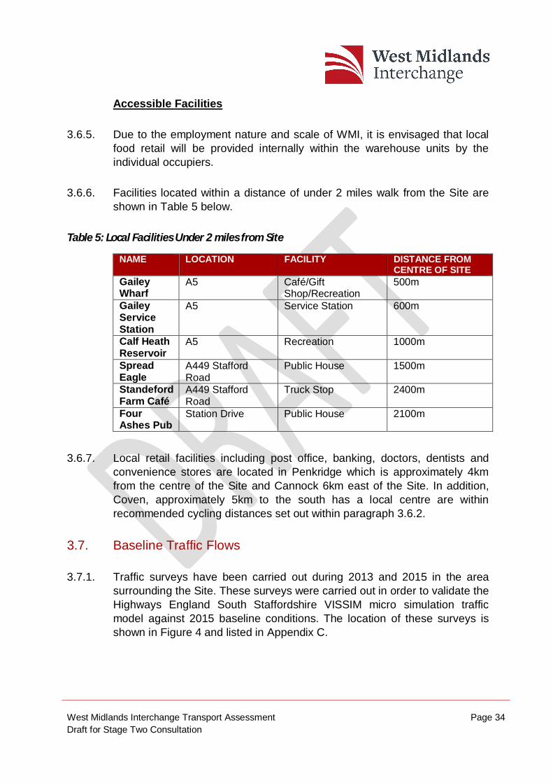
3.6. Accessibility to Local Facilities
Walking & Cycling Distances
3.6.1. The Design Manual for Roads and Bridges (DMRB) Transport Advice 91/05 Provision for Non-Motorised Users states that a distance of two miles could easily be walked by the majority of people. Paragraphs 2.2 and 2.3 state the following:
“Walking is a means of travel in its own right, but is an essential part of many other journeys, including those by car and public transport. However, there has been a decline in both the number and distance of journeys on foot since the mid-1980s. Nearly half of all journeys are less than 2 miles, a distance that could easily be walked by the majority of people.”
“Walking is used to access a wide variety of destinations including educational facilities, shops, and places of work, normally within a range of up to 2 miles. Walking and rambling can also be undertaken as a leisure activity, often over longer distances.”
3.6.2. DMRB TA 91/05 also refers to cycling distances, Paragraph 2.9 states that “Nearly three quarters of all journeys are less than 5 miles (8km) in length, distances that could easily be cycled by the majority of people”, and in Paragraph 2.11 that “cycling is used for accessing a variety of different destinations, including educational facilities, shops and places of work, up to a range of around 5 miles.”
3.6.3. The National Travel Survey highlights that the average cycle trip is currently three miles (4.9 km). Local Transport Note 1/04 highlights the average distance travelled by Non-Motorised Users (NMUs) at that time, and suggests in paragraph 3.10.3 that “…journeys up to three times [the average distance] are not uncommon for regular commuters” accepting that “fitness and physical ability, journey purpose…and conditions” are relevant factors.
3.6.4. It should also be noted that this distance is an average distance, and consequently people are willing to regularly cycle further.
West Midlands Interchange Transport Assessment Page 34 Draft for Stage Two Consultation
Accessible Facilities
3.6.5. Due to the employment nature and scale of WMI, it is envisaged that local food retail will be provided internally within the warehouse units by the individual occupiers.
3.6.6. Facilities located within a distance of under 2 miles walk from the Site are shown in Table 5 below.
Table 5: Local Facilities Under 2 miles from Site
NAME LOCATION FACILITY DISTANCE FROM CENTRE OF SITE
Gailey Wharf
A5 Café/Gift Shop/Recreation
500m
Gailey Service Station
A5 Service Station 600m
Calf Heath Reservoir
A5 Recreation 1000m
Spread Eagle
A449 Stafford Road
Public House 1500m
Standeford Farm Café
A449 Stafford Road
Truck Stop 2400m
Four Ashes Pub
Station Drive Public House 2100m
3.6.7. Local retail facilities including post office, banking, doctors, dentists and convenience stores are located in Penkridge which is approximately 4km from the centre of the Site and Cannock 6km east of the Site. In addition, Coven, approximately 5km to the south has a local centre are within recommended cycling distances set out within paragraph 3.6.2.
3.7. Baseline Traffic Flows
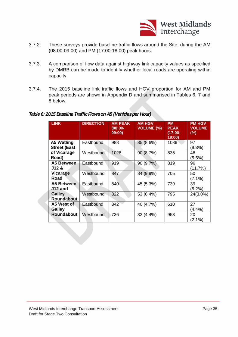
3.7.1. Traffic surveys have been carried out during 2013 and 2015 in the area surrounding the Site. These surveys were carried out in order to validate the Highways England South Staffordshire VISSIM micro simulation traffic model against 2015 baseline conditions. The location of these surveys is shown in Figure 4 and listed in Appendix C.
West Midlands Interchange Transport Assessment Page 35 Draft for Stage Two Consultation
3.7.2. These surveys provide baseline traffic flows around the Site, during the AM (08:00-09:00) and PM (17:00-18:00) peak hours.
3.7.3. A comparison of flow data against highway link capacity values as specified by DMRB can be made to identify whether local roads are operating within capacity.
3.7.4. The 2015 baseline link traffic flows and HGV proportion for AM and PM peak periods are shown in Appendix D and summarised in Tables 6, 7 and 8 below.
Table 6: 2015 Baseline Traffic Flows on A5 (Vehicles per Hour)
LINK DIRECTION AM PEAK (08:00-09:00)
AM HGV VOLUME (%)
PM PEAK (17:00-18:00)
PM HGV VOLUME (%)
A5 Watling Street (East of Vicarage Road)
Eastbound 988 85 (8.6%) 1039 97 (9.3%)
Westbound 1028 90 (8.7%) 835 46 (5.5%)
A5 Between J12 & Vicarage Road
Eastbound 919 90 (9.7%) 819 96 (11.7%)
Westbound 847 84 (9.9%) 705 50 (7.1%)
A5 Between J12 and Gailey Roundabout
Eastbound 840 45 (5.3%) 739 39 (5.2%)
Westbound 822 53 (6.4%) 795 24(3.0%)
A5 West of Gailey Roundabout
Eastbound 842 40 (4.7%) 610 27 (4.4%)
Westbound 736 33 (4.4%) 953 20 (2.1%)
West Midlands Interchange Transport Assessment Page 36 Draft for Stage Two Consultation
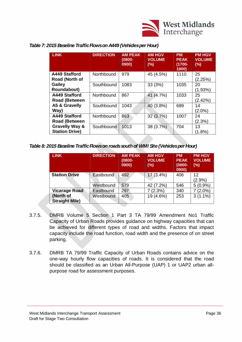
Table 7: 2015 Baseline Traffic Flows on A449 (Vehicles per Hour)
LINK DIRECTION AM PEAK (0800-0900)
AM HGV VOLUME (%)
PM PEAK (1700-1800)
PM HGV VOLUME (%)
A449 Stafford Road (North of Gailey Roundabout)
Northbound 979 45 (4.5%) 1110 25 (2.25%)
Southbound
1083 33 (3%) 1035 20 (1.93%)
A449 Stafford Road (Between A5 & Gravelly Way)
Northbound 867 41 (4.7%) 1033 25 (2.42%)
Southbound
1043 40 (3.8%) 689 14 (2.0%)
A449 Stafford Road (Between Gravelly Way & Station Drive)
Northbound 863 32 (3.7%) 1007 24 (2.3%)
Southbound
1013 38 (3.7%) 704 13 (1.8%)
Table 8: 2015 Baseline Traffic Flows on roads south of WMI Site (Vehicles per Hour)
LINK DIRECTION AM PEAK (0800-0900)
AM HGV VOLUME (%)
PM PEAK (0800-0900)
PM HGV VOLUME (%)
Station Drive Eastbound 492 17 (3.4%) 406 12 (2.9%)
Westbound 579 42 (7.2%) 546 5 (0.9%) Vicarage Road (North of Straight Mile)
Eastbound 297 7 (2.3%) 340 7 (2.0%) Westbound 405 19 (4.6%) 253 3 (1.1%)
3.7.5. DMRB Volume 5 Section 1 Part 3 TA 79/99 Amendment No1 Traffic Capacity of Urban Roads provides guidance on highway capacities that can be achieved for different types of road and widths. Factors that impact capacity include the road function, road width and the presence of on street parking.
3.7.6. DMRB TA 79/99 Traffic Capacity of Urban Roads contains advice on the one-way hourly flow capacities of roads. It is considered that the road should be classified as an Urban All-Purpose (UAP) 1 or UAP2 urban all-purpose road for assessment purposes.
West Midlands Interchange Transport Assessment Page 37 Draft for Stage Two Consultation
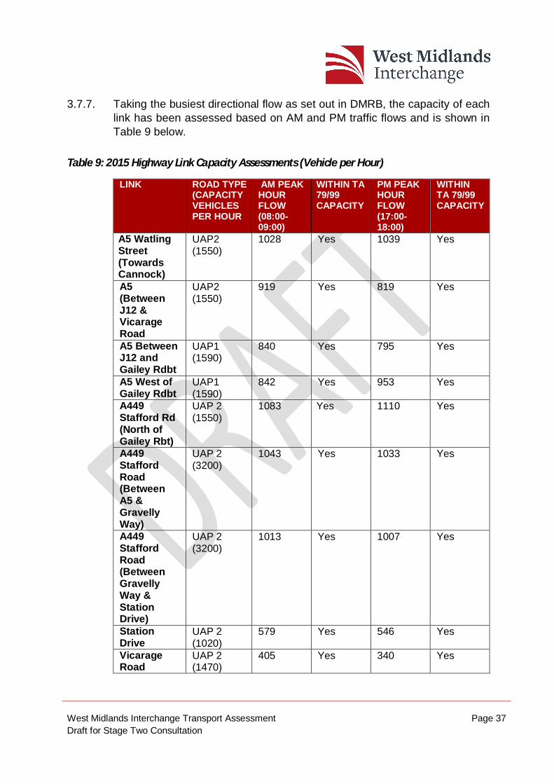
3.7.7. Taking the busiest directional flow as set out in DMRB, the capacity of each link has been assessed based on AM and PM traffic flows and is shown in Table 9 below.
Table 9: 2015 Highway Link Capacity Assessments (Vehicle per Hour)
LINK ROAD TYPE (CAPACITY VEHICLES PER HOUR
AM PEAK HOUR FLOW (08:00-09:00)
WITHIN TA 79/99 CAPACITY
PM PEAK HOUR FLOW (17:00-18:00)
WITHIN TA 79/99 CAPACITY
A5 Watling Street (Towards Cannock)
UAP2 (1550)
1028 Yes 1039 Yes
A5 (Between J12 & Vicarage Road
UAP2 (1550)
919 Yes 819 Yes
A5 Between J12 and Gailey Rdbt
UAP1 (1590)
840 Yes 795 Yes
A5 West of Gailey Rdbt
UAP1 (1590)
842 Yes 953 Yes
A449 Stafford Rd (North of Gailey Rbt)
UAP 2 (1550)
1083 Yes 1110 Yes
A449 Stafford Road (Between A5 & Gravelly Way)
UAP 2 (3200)
1043 Yes 1033 Yes
A449 Stafford Road (Between Gravelly Way & Station Drive)
UAP 2 (3200)
1013 Yes 1007 Yes
Station Drive
UAP 2 (1020)
579 Yes 546 Yes
Vicarage Road
UAP 2 (1470)
405 Yes 340 Yes
West Midlands Interchange Transport Assessment Page 38 Draft for Stage Two Consultation
3.7.8. As can be seen from Table 9 above, all the roads surrounding the Site operate within capacity thresholds set out within DMRB.
3.8. Personal Injury Accident Data
3.8.1. Personal Injury Accident (PIA) data has been obtained from Staffordshire County Council for the most recent five year period (1/7/2011 to 30/6/2016). The full accident report can be made available on request. A map showing the location of recorded accidents is shown in Figure 5.
3.8.2. The data shows during this period a total of 119 accidents over the five year period of which 109 were classified as slight, nine serious, with one fatality.
3.8.3. In terms of casualties, 13 involved pedal cyclists (12 Slight, one Serious) and three involved pedestrians (two Slight, one Serious).
Junctions
3.8.4. A review of the accidents that have occurred at each junction and on within the following paragraphs and is summarised in Table 10 below.
Table 10: Personal Injury Accident Data at Junctions
JUNCTION SEVERITY VULNERABLE ROAD USER
SLIGHT SERIOUS FATAL PED CYCLE MOTOR CYCLE
M6 Junction 12 12 1 1 1 0 3 Gailey Roundabout
16 1 0 0 6 2
A5 Watling Street/ Four Crosses Lane
7 0 0 0 0 1
A449/Vicarage Road
3 1 0 0 1 0
M6 Junction 12
3.8.5. There have been 14 PIAs recorded at the M6 Junction 12 gyratory and slip roads. Of these incidents, one accident was classified as fatal, the
West Midlands Interchange Transport Assessment Page 39 Draft for Stage Two Consultation
description of the accident is not provided in accident data, but the principal contributory factor was loss of control. There was one serious and 12 slight PIA at this location. The most common contributory factor in the 13 non-fatal accidents was failed to look properly, as this was included in six of the 13 accidents.
Gailey Roundabout
3.8.6. There have been 17 PIAs recorded at the Gailey Roundabout. Of these incidents, one accident was classified as serious and the 16 remaining accidents were classified as slight. Eight of the slight collisions involved vulnerable road users. In six of these incidents, a cyclist was involved and in two a motor-cyclist. Failure to look properly was the contributory factor in six of the accidents.
A449 / Vicarage Road
3.8.7. Four personal injury accidents were recorded at the A449 / Vicarage Road junction. One of these accidents was classified as Serious and the remaining accidents were classified as Slight.
3.8.8. The serious accident occurred when a vehicle doing a right turn failed to look properly a collided with other vehicle. For the slight accidents, the contributory factor in two of the accidents was failed to look properly, whilst for the other accident the contributory factor was defective brakes.
Links
3.8.9. Personal Injury Accidents that have occurred along specific links around the area of the Site are summarised in Table 11 and in the paragraphs below.
West Midlands Interchange Transport Assessment Page 40 Draft for Stage Two Consultation
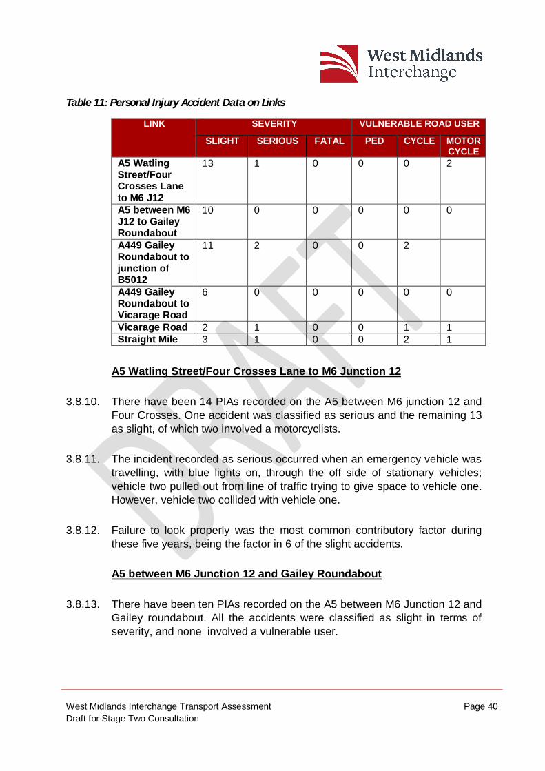
Table 11: Personal Injury Accident Data on Links
LINK SEVERITY VULNERABLE ROAD USER
SLIGHT SERIOUS FATAL PED CYCLE MOTOR CYCLE
A5 Watling Street/Four Crosses Lane to M6 J12
13 1 0 0 0 2
A5 between M6 J12 to Gailey Roundabout
10 0 0 0 0 0
A449 Gailey Roundabout to junction of B5012
11 2 0 0 2
A449 Gailey Roundabout to Vicarage Road
6 0 0 0 0 0
Vicarage Road 2 1 0 0 1 1 Straight Mile 3 1 0 0 2 1
A5 Watling Street/Four Crosses Lane to M6 Junction 12
3.8.10. There have been 14 PIAs recorded on the A5 between M6 junction 12 and Four Crosses. One accident was classified as serious and the remaining 13 as slight, of which two involved a motorcyclists.
3.8.11. The incident recorded as serious occurred when an emergency vehicle was travelling, with blue lights on, through the off side of stationary vehicles; vehicle two pulled out from line of traffic trying to give space to vehicle one. However, vehicle two collided with vehicle one.
3.8.12. Failure to look properly was the most common contributory factor during these five years, being the factor in 6 of the slight accidents.
A5 between M6 Junction 12 and Gailey Roundabout
3.8.13. There have been ten PIAs recorded on the A5 between M6 Junction 12 and Gailey roundabout. All the accidents were classified as slight in terms of severity, and none involved a vulnerable user.
West Midlands Interchange Transport Assessment Page 41 Draft for Stage Two Consultation
3.8.14. Failed to look properly, following too close and failed to judge other persons path or speed were the most common contributory factors.
A449 Gailey Roundabout to junction of B5012
3.8.15. There have been thirteen accidents recorded on this section of the A449 Stafford Road. Two accidents were classified as ‘serious’ and eleven as ‘slight’. Four accidents involved vulnerable road users; two involved a cyclist and two a motor-cyclist.
3.8.16. Both ‘serious’ accidents involved a motor-cyclist, at separate arms on the roundabout and the contributory factor of both of them was ‘Failed to look properly’. The remaining ‘Slight’ accidents were as a result of following too close the other vehicle and failed to look properly.
A449 Stafford Road to Vicarage Road
3.8.17. There have been six accidents on the A449 Stafford Road between Gailey roundabout and the crossing with Vicarage Road. None involved a vulnerable user.
3.8.18. Five of the accidents recorded in this link occurred on the crossroads between Crateford Lane/Gravelly and had a common contributory factor of ‘Poor turn or manoeuvre’.
Vicarage Road
3.8.19. There have been three accidents on Vicarage Road. One of the accidents was classified as ‘Serious’ and the rest as ‘Slight’ in terms of severity. Two of these three accidents involved a vulnerable user; one involved a cyclist and the other a motor-cyclist.
3.8.20. The incident recorded as ‘Serious’ was due to the result of motor-cyclist driving impaired by alcohol.
West Midlands Interchange Transport Assessment Page 42 Draft for Stage Two Consultation
3.9. Summary
3.9.1. By its nature as a SRFI, WMI is well served from the motorway and strategic A road network, being bounded by the M6, A5 and A449.
3.9.2. The Site currently benefits from public transport provision and is well served from bus stops located on the A449. The nearest rail station is Penkridge, which is located 4km to the north of the Site and is connected to the Site through footways and cycleways, providing opportunities for employees at WMI to walk/cycle to the Site. In addition, Stafford and Wolverhampton rail stations, located 7 km and 10km away from the Site respectively provide opportunities for workers at WMI to travel as part of a multi modal trip.
3.9.3. It is noted that the majority of accidents are related to driver behaviour (failed to look properly, loss of control or driver misjudgement) rather than issues of geometry, sight lines and road alignment.
West Midlands Interchange Transport Assessment Page 43 Draft for Stage Two Consultation
4. DEVELOPMENT PROPOSALS 4.1. Introduction
4.1.1. This section provides details of the development proposals.
4.1.2. A ‘Parameters Approach’ has been applied to the Proposed Development whereby the development is described in terms of clearly defined parameters inside which future design development will be undertaken. This approach is used across a range of infrastructure projects in order to ensure that the potential impacts of a project are properly controlled whilst allowing flexibility in design options for future design development.
4.1.3. Three sets of Parameter Plans [Document Refs. 2.5 – 2.7] have been developed which encapsulate the scheme’s concept and which will form the ‘envelope’ within which future detailed design proposals will need to evolve.
4.1.4. The Parameter Plans identify those elements of the scheme which are to be fixed or controlled as part of the DCO (i.e. the location of development plots and the framework of green infrastructure) and those elements which are subject to restrictions. The three Parameter Plans which set out the design parameters are:
Building Development Parameter Plan;
Green Infrastructure Parameter Plan; and
Floor Level and Building Heights Parameter Plan.
4.1.5. An Illustrative Masterplan [Document Ref 2.8] has also been produced which demonstrates one way in which the WMI proposals could potentially come forward, in accordance with the controls set out in the Parameter Plans.
4.1.6. This section provides details of the development proposals. This description should be read in conjunction with the Parameters Plans [Documents 2.5 – 2.7], Schedule 1 of the Draft Development Consent Order [Document 3.1]
West Midlands Interchange Transport Assessment Page 44 Draft for Stage Two Consultation
and the Works Plans [Document 2.2] to be submitted as part of the application for Development Consent.”
4.1.7. The Building Development Parameter Plans and the Illustrative Masterplan indicating how the Proposed Development could be introduced are shown in Appendix E.
4.1.8. The Proposed Development comprises:
An intermodal freight terminal with direct connections to the West Coast Main Line (WCML), capable of accommodating up to 10 trains per day and trains of up to 775m long, including container storage, Heavy Goods Vehicle parking, rail control building and staff facilities;
Up to 743,200 square metres of rail served warehousing and ancillary service buildings;
New road infrastructure and works to the existing road infrastructure;
Demolition of existing structures and earthworks to create development plots and landscape zones;
Repositioning and burying of electricity pylons and cables; and
Strategic landscaping and open space, including alterations to public rights of way and the creation of new ecological enhancement areas and publicly accessible open areas.
4.1.9. The Proposed Development is described in detail within the Planning Statement prepared by Quod (Document Reference 7.1), however, those elements relevant to the TA are summarised below.
4.1.10. A freight terminal is proposed, to be connected to, and immediately west of, the WCML.
4.1.11. The freight terminal is designed to accommodate up to 10 trains per day, and to accommodate trains of up to 775m in length (the maximum length of UK and European intermodal trains), without the need to ‘break’ the trains.
West Midlands Interchange Transport Assessment Page 45 Draft for Stage Two Consultation
The freight terminal would enable the transfer of freight from road to rail, and vice versa.
4.1.12. In addition to serving the operators located on the WMI Site itself, the freight terminal would also be an open terminal so that it could serve a wider market, enabling the transfer, storage and distribution, as required, of containers and other goods. Areas for container storage and a 75 space HGV parking area are proposed to be provided at and adjacent to the rail terminal.
4.1.13. The freight terminal would connect directly to the WCML via north and south facing connections, giving direct access to the principal UK ports at Southampton, Felixstowe, London Gateway plus other smaller container ports, the Channel Tunnel and many of the key UK regional distribution cluster locations.
4.1.14. At start-up and based on equivalent UK terminal operations, WMI is expected to handle 4 trains per day in its earlier phases, rising over time up to 10 trains per day.
4.1.15. The WMI project proposes up to 743,200 sqm (8 million sq ft) of rail served warehouse space. A small amount of space for ancillary buildings relating to the freight terminal and storage areas is also proposed.
4.1.16. The final and detailed configuration of the warehousing would be determined in response to market demand but the expectation is that the development would comprise large floorplate buildings.
4.1.17. The draft Illustrative Masterplan provided at Appendix E, demonstrates one way in which the Site could potentially be developed in accordance with the Parameters Plans.
4.2. Access and Highways Works
4.2.1. The WMI project contains a number of road infrastructure elements, including new roads, and improvements to existing roads. These are described more fully within Chapter 5 - Transport Strategy.
4.2.2. Principal new highways works include:
West Midlands Interchange Transport Assessment Page 46 Draft for Stage Two Consultation
the construction of a new roundabout on the A5, providing access to the Site;
the construction of a new roundabout on the A449, providing access to the Site;
the construction of a new roundabout on Vicarage Road, providing access to the Site;
the construction of a new road between the new A5 and A449 roundabouts;
the construction of two new bridges, one across the Canal and one across the WCML to facilitate the new road between the A5 and A449; and
the construction of a new road off the new A5 to A449 road, linking with the new Vicarage Road roundabout.
4.2.3. In addition, the following other works are proposed to the local highway network to facilitate access to the Site and mitigate the impacts of the Proposed Development:
the alteration of the existing junction layout at the A449 / Station Drive traffic signals;
amending Crateford Lane to make it one way to the A449 (eastwards) from the last property on Crateford Lane;
realigning and improving Gravelly Way, including replacing the substandard bridge over the WCML;
widening to 3m the existing footway / cycleway along the east side of the A449 from Station Drive to Gailey Roundabout;
new A449 laybys;
West Midlands Interchange Transport Assessment Page 47 Draft for Stage Two Consultation
upgrading the existing footway along the A5 from Gailey Roundabout to the new A5 access to a combined footway / cycleway;
alterations to the Harrison Lane (north of the A5) access;
the provision of a new footway / cycleway on Vicarage Road from the new Site access roundabout to the existing footway on the canal bridge;
the provision of new footways at the junctions of Straight Mile / Kings Road / Woodlands Lane together with crossing facilities; and
the construction of a HGV turning area on Station Drive to the west of the WCML bridge.
4.3. Phasing of Works
4.3.1. The delivery of WMI will be phased over a fifteen year development period from 2021 to 2036. A total of five phases are proposed and shown on the Phasing Plan included in the Planning Statement [Document Ref 7.1] and provided at Appendix E. The estimated amount of floorspace to be built in each phase (based on the draft Illustrative Masterplan) is set out below:
Phase 1 Estimated total floorspace 262,672 sqm
Phase 2 – Estimated total floorspace 162,524 sqm
Phase 3 - Estimated total floorspace 57,921 sqm
Phase 4 - Estimated total floorspace 147,414 sqm
Phase 5 - Estimated total floorspace 100,503 sqm
4.3.2. Phase 1 will be the largest phase of development. The majority of Phase 1 works are located immediately south of the A5 as well as to the east of the A449 and accessed from the roundabout between the A5 and the new access road (Access Road 1). This new three arm roundabout will provide the primary access to the site.
West Midlands Interchange Transport Assessment Page 48 Draft for Stage Two Consultation
4.3.3. Proposed landscaping and water attenuation will also be introduced within this phase to the south of the A5 and to the west of the new access road from the A5. This area will be known as Croft Lane Community Park.
4.3.4. Phase 1 also includes the completion of the development access road from the A5 linking to the A449.
4.3.5. In addition, Plot 1030, which is bounded by the A449 to the west and the railway line to the east will be introduced along with the first phase on the Intermodal Terminal and the new rail lines associated with this as well as landscaping to the south of Gravelly Way. This will be accessed from the new access road which will have a junction with the A449 approximately 100m to the west.
4.3.6. Phase 2 will mainly be located to the south east of Phase 1 and will include two warehouse units which will be accessed from the A5 via the new access road and other site roads built as part of this phase.
4.3.7. In addition, phase 2 of the Intermodal Terminal will be constructed and will include additions to rail storage, container storage, parking areas and associated landscaping. This will be accessed via the access road from the A449.
4.3.8. Phase 3 will include the units to the south west abutted by the A449 and to the east by the railway line. Access will be via the new access road from the A449 and the internal road network built out as part of this phase.
4.3.9. Phase 4 will involve the construction of three warehouse units. This is located to the south east of Phase 2 and to the north west of Vicarage Road. Access to this Phase will be via the A5 and Vicarage Road via the internal Site road network constructed during previous phases.
4.3.10. Phases 5 will continue the growth of the Site southwards from the Phase 4 development. Access during these phases can be via the A449 or A5 and onto Vicarage Road as the majority of the Site and internal road networks will be built out. This phase will also see the introduction of open space known as Calf Heath Community Park.
West Midlands Interchange Transport Assessment Page 49 Draft for Stage Two Consultation
4.4. Operation
4.4.1. The SRFI will operate for 24 hours a day, seven days a week, this means that there could be associated HGV movements throughout the week, generally the pattern is for uniform volumes between 0700-1900 with a lower level of activity at other times.
4.4.2. There tends to be two employment components namely office workers with conventional office hours and shift workers who conventionally work over the following three periods: 0600-1400, 1400-2200 and 2200-0600. As a result the employment traffic generation is spread out over a number of hours.
West Midlands Interchange Transport Assessment Page 50 Draft for Stage Two Consultation
5. TRANSPORT STRATEGY 5.1. Introduction
5.1.1. This section sets out the transport strategy to serve the Proposed Development including the walking / cycling, public transport and highway works that will serve WMI.
5.1.2. The Proposed Development will provide a range of on-site and off-site transport facilities to allow for movement towards the development. The transport strategy will also provide improvements to the local highway network to improve movement for existing travellers by all modes.
5.2. Highway Infrastructure
5.2.1. The Proposed Development includes significant highway works in order to serve the scheme and provide improvements for existing road users. These aspects of the strategy will ensure that appropriate access is provided for WMI traffic, ensure that the Proposed Development does not have an adverse impact upon the existing transport network and also provide improvements for some existing road users.
Access to Site
5.2.2. In order to facilitate highway access to the Proposed Development, it is proposed to construct three new roundabout junctions, The location of the proposed access points are shown in Figure 6 and the junction layouts contained in the General Arrangement Drawings shown in Appendix F and are as follows:
A5 Access (north of Site) – Construction of a new three arm roundabout from the A5;
A449 Access (west of Site) – Construction of a new four arm roundabout from the A449 with Gravelly Way and Crateford Lane. This will replace the existing traffic signal controlled junction; and
West Midlands Interchange Transport Assessment Page 51 Draft for Stage Two Consultation
Vicarage Road Access (south of Site) - Construction of a new four arm roundabout from Vicarage Road.
5.2.3. The junctions have been designed in accordance with standards contained in the DMRB Volume 6 Section 2 Part 3 TD 16/07 Geometric Design of Roundabouts.
5.2.4. In addition, it is proposed to construct a priority junction with Vicarage Road to serve a small amount of development floor space to the south west.
A5 Access
5.2.5. Given the close proximity to M6 Junction 12, the northern access on the A5 is the key access to the Proposed Development for vehicular traffic. The junction configuration would consist of a three arm roundabout with a diameter of approximately 60 metres.
5.2.6. Localised widening of the A5 would be required to accommodate flared approaches to the junction. The Calf Heath Quarry will make way in order to facilitate its development, however, this junction with the A5 will need to be retained in order to serve Avenue Cottages. The existing priority junction of A5 / Harrisons Lane will be converted to a left in / left out only arrangement. This will be physically enforced through the implementation of a right turn median. Flared single lane exits are provided on all arms of the junction. Two access points to the south of the A5 serving an existing property and agricultural land will be closed as part of the access works via the A5.
5.2.7. The roundabout is off set to the south to facilitate the necessary entry path deflection and kerb radii. This will also assist with the construction of the junction as around 75% of the configuration arrangement will be able to be undertaken offline. This will mean that the existing A5 carriageway can be kept open during the majority of the works. Once the main part of the junction has been constructed, it can be opened to traffic whilst the final part of the junction is completed.
5.2.8. Overall, there would not be a net gain in the number of roundabouts along the A5 as a consequence of the Proposed Development.
West Midlands Interchange Transport Assessment Page 52 Draft for Stage Two Consultation
5.2.9. The introduction of the A5 roundabout would require the closure of the existing A5 laybys. However, it is proposed to relocate these laybys so that they are adjacent to the A449. This is discussed later within this Chapter.
5.2.10. Pedestrians and cyclists are provided for at grade with uncontrolled access across all arms of the junction.
A449 Access
5.2.11. A second access to serve the Site is proposed from the A449 via a modified junction with Gravelly Way and Crateford Lane. Currently, the existing junction consists of a four arm traffic signal controlled cross roads,
5.2.12. The junction has recently been the subject of highway works that have seen the construction of the traffic signal junction which replaces the previous priority cross roads arrangement. This scheme was constructed in order to serve the consented Bericote development on land to the east of Gravelly Way. These works have been designed to serve the consented Bericote Development, rather than serving more strategic growth. It is proposed to replace this junction with a four arm roundabout with a diameter of approximately 60 metres in order to serve the additional traffic generated by both the Bericote consented scheme and the proposed SRFI.
5.2.13. The proposed junction arrangement would be off set to the east in order to accommodate the necessary entry path deflection. However, the A449 arms would not require widening on the approaches to the junction. Two lane exits on the A449 arms of the junction would be retained. To the west, it is proposed to convert Crateford Lane to one way in a west to east direction. The eastern arm within the Site would be flared on the approach to the junction, with a flared single lane exit provided. 100 metres further to the east would be the access to the intermodal terminal which would be served via a ghost island right turn lane.
5.2.14. Given that the A449 access would see the conversion of an existing junction, the access strategy would not see an increase in junctions with this section of the SRN.
5.2.15. Pedestrians and cyclists are provided for at grade with uncontrolled access across the southern, western and eastern arms of the junction.
West Midlands Interchange Transport Assessment Page 53 Draft for Stage Two Consultation
5.2.16. To the south of the proposed roundabout arrangement, improved bus stops will be provided. Connections towards the Site will be provided via improved footways and the crossing facilities described above. These bus stops would provide shelters and waiting facilities.
Vicarage Road Access
5.2.17. A third vehicular access is proposed from Vicarage Road to the south east of the development. This access junction would serve the southern part of the development and development land south of Vicarage Road.
5.2.18. This junction would take the form of a four arm roundabout with a diameter of approximately 50 metres. This would facilitate access to land either side of Vicarage Road. All arms are flared on the approach to the junction. Flared single lane exits are provided on all arms of the junction.
5.2.19. The junction configuration would be offset to the north in order to facilitate the necessary entry path deflection and kerb radii. This will assist with the construction of the junction as around 75% of the implementation of this arrangement will be able to be carried out offline. This will mean that the existing Vicarage Road carriageway can be kept open during the majority of the works. Once the main part of the junction has been constructed, it can be opened to traffic whilst the final part of the junction is completed.
5.2.20. Pedestrians and cyclists are provided for at grade with uncontrolled access across all arms of the junction.
5.2.21. In addition, a priority junction is proposed to be provided to the south of the Vicarage Road roundabout in order to serve a proportion of the southern element of WMI.
Adopted Road Through the Site
5.2.22. To mitigate the impact of WMI the Proposed Development will provide a road between the A5 and A449 roundabouts. This will be provided as a 30 mph adopted public highway to be maintained by Staffordshire County Council and will be available for use by public traffic at all times. This would be provided as a signed route to and from M6 Junction 12 and the A449.
West Midlands Interchange Transport Assessment Page 54 Draft for Stage Two Consultation
5.2.23. This route will provide a 7.3 metre carriageway together with a 3 metre shared use cycle footway provided adjacent to the east and north bound carriageway. The width of the route will widen in order to facilitate right turn lanes to serve development plots. Pedestrian crossing islands will be provided in the vicinity of the access junctions to the development plots a 24 hour clearway will be provided along the route in order to prevent on carriageway parking.
5.2.24. This road will improve the operation and resilience of the Gailey Roundabout by providing a choice of routes for trunk road traffic travelling between the A5 and A449.
5.2.25. A new bridge structure will be provided in order to cross both the WCML and the Staffordshire and Worcestershire Canal. The provision of this new bridge will enable the closure and removal of the existing Gravelly Way railway bridge. All existing land along Gravelly Way that is adopted and which is not required to accommodate highway infrastructure will be stopped up. The existing Gravelly Way canal bridge will however, remain due to the need to retain access to the Bericote development to the east and SI land to the south. Both of these uses will be served via a new non adopted five arm roundabout that is located to the south of the route through the Site.
Non Adopted Road Through the Site
5.2.26. In addition to the adopted route through the Site, a further traffic route will be provided to the south east towards Vicarage Road. The two routes will connect via a new three arm roundabout located within the Site approximately 500 metres to the south of the A5.
5.2.27. Whilst this route will not be offered for adoption by Staffordshire County Council, it will be provided to adoptable standards. However, for operation purposes, the applicant wishes to be able to retain an element of control of the highway infrastructure that will be provided within certain areas of the Site.
West Midlands Interchange Transport Assessment Page 55 Draft for Stage Two Consultation
5.2.28. This route will provide access to the majority of development plots, however the purpose of the route is not to provide a strategic function in terms of traffic distribution, but act as an access to the core parts of the site. There may also be a need for the developer to restrict public access to this area from time to time for operational reasons which would not be possible if the route were adopted.
5.2.29. Therefore, there is no need for it to be offered for adoption by the Highway Authority. Whilst public use of this route will not be precluded for the majority of the time, it is not proposed that it will provide a signed traffic route for through traffic.
5.2.30. This route would consist of a 7.3 metres carriageway, which would widen at the development plot access junctions in order to provide right turn lanes. 3 metres cycleway/footways would be provided adjacent to both sides of the carriageway, with at grade crossing facilities by way of pedestrian refuge islands.
Crateford Lane
5.2.31. To ensure vehicle movement both in terms of existing traffic activity as well as from WMI utilises the SRN and appropriate local routes rather than lower class routes, it is proposed that, as part of the works to provide the A449 roundabout, Crateford Lane would be converted to a one way only route in a west to east direction. There would therefore, be no entry into Crateford Lane from the A449. This would preclude the opportunity for traffic from the A449 to rat run through the villages of Brewood to the west in order to avoid The Gailey Roundabout.
Station Drive
5.2.32. The introduction of physical works will be implemented to ban traffic travelling northbound along the A449 from turning right into Station Drive with the result that through traffic on Station Drive will transfer to the new Site whilst local access is facilitated by making a U turn at the new A449 Gravelly Way roundabout.
West Midlands Interchange Transport Assessment Page 56 Draft for Stage Two Consultation
5.2.33. Currently the junction of Station Drive and the A449 is subject to peak period queuing. Station Drive and Station Road also have a number of properties with direct frontage and there is a low railway bridge which can give rise to problems for over height vehicles.
5.2.34. The Station Drive / Vicarage Road corridor is known to experience rat running traffic travelling towards the A5 in order to avoid The Gailey Roundabout. The implementation of the right turn ban will prevent rat running traffic from the south from being able to reach the A5 by using Station Drive and onto Vicarage Road as a means to avoid the Gailey Roundabout.
5.2.35. Banning this right turn will reduce the level of existing traffic using Station Drive in order to reach the A5 to the north. In relation to the Proposed Development, it will ensure that WMI traffic from the south will not be able to access the development from this route and instead will need to use the A449 junction in order to reach the Site.
5.2.36. In addition to the right turn ban it is also proposed to provide an HGV turning area on the west side of the railway bridge on Station Drive. This means that any HGVs which do inadvertently turn into Station Drive can turn around without striking the bridge or causing traffic disruption.
A449 Layby’s
5.2.37. The introduction of the A5 access roundabout requires the removal of the existing layby’s from the A5. The Highway Authorities have advocated that replacement layby’s be considered and details of how these could be provided adjacent to the A449 have been provided on the General Arrangement drawings provided at Appendix F. It should be noted that the land to the west of the A5 is within the control of the Applicant.
5.2.38. If required by the Highway Authority’s, these laybys could be provided in order to supplement Highways Englands current proposals to provide further laybys along the A449.
West Midlands Interchange Transport Assessment Page 57 Draft for Stage Two Consultation
5.3. Sustainable Transport Strategy
5.3.1. A Sustainable Transport Strategy has been prepared which proposes a number of infrastructure improvements and management measures in order to provide opportunities to reach the Site using non car modes, either by way of active modes such as walking or cycling as well as by way of public transport.
5.3.2. The overall aim of the Sustainable Transport Strategy is to create an environment for employees that actively promotes a range of sustainable, low carbon travel choices and reduces the overall need to commute to work by car.
5.3.3. This strategy underpins the policy requirement to achieve a modal shift away from Single Occupancy Vehicle journeys. Full details of the Sustainable Transport Strategy are provided in Technical Note 19, which is provided at Appendix G.
5.3.4. The proposed public transport strategy is shown in Figure 7.
Public Transport
5.3.5. It is proposed to improve the existing public bus services to the Site, this could potentially include an additional two new buses and an enhanced service frequency between Wolverhampton City Centre and WMI. These potential improvements would enhance the existing Service 54 to provide a half hourly service between Wolverhampton and the Site. These buses would serve the improved bus stops on the A449 and those located in the vicinity of the Gailey Roundabout.
5.3.6. To incorporate access to the Site the existing bus route would potentially divert into the Site via the proposed roundabout junction with the A449 and through the Site before emerging at the A5. It is envisaged that two new buses required to support an improved frequency, will not operate any further north than the Site and would terminate within the Site with the potential to commence a reverse trip to Wolverhampton.
West Midlands Interchange Transport Assessment Page 58 Draft for Stage Two Consultation
5.3.7. Should demand or aspirations of the operator or other Stakeholders be to improve the service frequency between WMI, Penkridge, Stafford or any other destination, the proposals do not preclude this from being implemented in the future.
Shuttle Bus
5.3.8. In addition to the potential enhancements to the existing Service 54, it is proposed that potentially up to three shuttle bus services could be provided between the Site and significant clusters of employees. Based on current demographics these are likely to be Cannock Chase, Walsall and the wider Wolverhampton urban area, however in practice the clusters will be informed by the personalised planning to be undertaken with the Travel Plan which may identify other areas of South Staffordshire.
5.3.9. Providing a shuttle bus to Cannock Chase, Walsall and the wider Wolverhampton area would serve the areas of highest forecast employee numbers and trip demand. Approximately 48% of future workers are forecast to come from these areas.
5.3.10. In addition, these areas do consist of specific population centres which lend themselves, to being able to provide specific pick up and drop off points for future workers.
5.3.11. Shuttle bus arrivals and departures would coincide with shift patterns and office hours. The buses would require capacity for approximately 20 to 40 passengers.
5.3.12. Bus stops would be provided on-site in the vicinity of the internal roundabout as well as on the eastern internal road. Provision would be made for bus shelters and waiting facilities.
Walking and Cycling
5.3.13. To improve the main pedestrian and cycle route connections to WMI the following improvements are proposed as follows:
Upgrade the existing shared use cycle/footway to 3 metre wide shared cycleway/footway to the east of A449 between Gailey Roundabout and the junction with Station Drive to the south;
West Midlands Interchange Transport Assessment Page 59 Draft for Stage Two Consultation
Provide pedestrian crossing facilities at the proposed A449 Site access roundabout to facilitate access to bus facilities to the west;
Upgrade existing footway to the west of the A449 in the vicinity of the proposed Site access roundabout to provide a width of 2 metres;
Alter the existing footway adjacent to the north of the A5 to provide where feasible a 3 metre wide shared cycleway/footway. This will be introduced along the A5 between Gailey Roundabout and the proposed Site access from the north. It is not possible to provide a full 3 metre width along the entirety of this route given the existing railway bridge and due to limited land availability in certain areas further to the east. The proposed roundabout junction with the A5 will also incorporate suitable crossing facilities into the Site;
Provision of a new footway from the A5 access roundabout towards the Gailey Marina;
Upgrade the section of towpath on the Staffordshire and Worcestershire Canal that is present within the Site; that is from the bridge over Vicarage Road to the south to Gailey Marina to the north. Improvements could include widening and resurfacing along the route, but developed in consultation with the Canals and River Trust. This improvement will provide a route for pedestrians and cyclists who may prefer to travel away from road traffic;
Provide a 3 metre cycleway / footway along the section of Vicarage Road between the existing bridge over the Canal and the proposed Site access. and
Provide pedestrian crossing facilities at the new four arm Site access roundabout junction with Vicarage Road.
West Midlands Interchange Transport Assessment Page 60 Draft for Stage Two Consultation
5.3.14. In addition, the highway provided on-site will provide 3 metres shared use cycle/footways which will provide further opportunities for movement by these modes. These routes will be supplemented by a network of Permissive Paths, which will provide access to the Community Parks that the Proposed Development will provide. The permissive paths will, where possible, link to the Canal Towpath as well as to specific car parking areas that are proposed and will provide replacement facilities for Footpath 29 that will make way to accommodate the Proposed Development.
5.3.15. From the south, at grade pedestrian crossing facilities are proposed in order to allow crossing of Straight Mile towards the permissive paths within the Calf Heath Community Park. It is also proposed to provide new footways at the junction of Straight Mile / Kings Road / Woodlands Lane together with crossing facilities.
5.3.16. The provision of this network of pedestrian facilities will ensure access to the Community Parks will be possible for those existing residents who may wish to visit these areas.
5.4. Framework Workplace Travel Plan
5.4.1. A Framework Workplace Travel Plan (FWTP) has been prepared to promote sustainable travel to the Site for workers and visitors. This is shown in Appendix H.
5.4.2. This Site wide objectives of the FWTP are in line with national and local policies which are to:
Minimise the overall proportion of single-occupancy car trips associated with commuting to and from the Site;
Reduce the overall need to travel to and from the Proposed Development, especially by private car;
Facilitate and encourage the use of healthy, low carbon and sustainable transport options amongst employees and visitors to the Site;
West Midlands Interchange Transport Assessment Page 61 Draft for Stage Two Consultation
Ensure that the differing transport needs of all site users are taken into account as far as practicable;
Work in partnership with the local planning and highway authorities, and other key stakeholders locally, to achieve both site-specific and area-wide reductions in single-occupancy car-based commuting; and
Continually develop, evaluate and review progress of the FWTP delivery.
5.4.3. The four main strands of the FWTP measures are:
Improving sustainable transport services and facilities;
Promotion and marketing;
Promoting more efficient car use; and
Introducing smart working practices.
5.4.4. The FWTP for WMI will operate under a specific brand identity which will be promoted to employees and a single online website portal will bring together transport information for the Site, to promote sustainable transport and enable employees to make an informed choice on their mode of travel to the Site; this will be supported by Personalised Travel Planning sessions which will be delivered to businesses at WMI. In addition, a number of measures can be promoted including employee/workplace engagement ‘challenges’ , employee discounts and promotions.
5.4.5. To promote more efficient use of car journeys, a car sharing portal will be created and promoted to employees, supported by a ‘guaranteed ride home scheme’.
5.4.6. The car sharing portal will provide an ideal platform for employees with the same, or very similar, commuting origins to find a suitable car-sharing partner to share their journey to the Site. More car-based journeys will therefore be made with higher vehicle occupancy and in a more efficient manner, and with overall car trips reduced.
West Midlands Interchange Transport Assessment Page 62 Draft for Stage Two Consultation
5.4.7. Local evidence from the i54 Business Park, which is located relatively near to WMI, shows the effect the introduction of a car sharing scheme can have on the proportion of commuting journeys. At Jaguar Land Rover, from a baseline level of 21% of commutes made by car sharing, the introduction and promotion of car sharing grew to 25% after two years. The proportion of single-occupancy car drivers fell from 62% to 56% over the same period, suggesting car sharing can play a key role on reducing the overall number of car-based vehicle trips.
5.4.8. In addition to site specific strategies and promoting, there is also scope for travel planning measures to be delivered on a wider scale across the A449 Stafford Road Corridor, which includes the i54 Business Park and share best practice and resource, to leverage greater returns on combined investment in sustainable transport services and promotional initiatives.
5.4.9. Where possible and having regard to the nature of the type of jobs that would be provided at WMI, smarter working practices, including flexible and/or staggered working hours and remote/home working will be promoted by the TPC and discussed with employers at WMI to reduce car borne trips.
5.4.10. Upon first occupation of WMI, a site wide Travel Plan Co-ordinator (TPC) will be appointed, to effectively deliver the FWTP and the measures outline, in a co-ordinated fashion.
5.5. Framework HGV Management Plan
5.5.1. From a transport perspective, the location of the Site is well-suited to the provision of an SRFI because it affords direct access to the national rail system, is located within very close proximity of a motorway junction, has direct access to the strategic road network; and is close to several large built up areas including Wolverhampton, Walsall and Stafford.
5.5.2. In order to ensure HGV traffic does not impact on local roads and villages surrounding the Site, a series of measures have been identified to be implemented through the proposed Framework HGV Management Plan (FHGVMP). A FHGVMP has been prepared as a separate document in order to support the submission of Stage Two Consultation material. This is shown in Appendix I.
West Midlands Interchange Transport Assessment Page 63 Draft for Stage Two Consultation
5.5.3. In addition, the FHGVMP can adopt practices which maximise the efficiency of HGV journeys in order to facilitate sustainable transport. Full details of the overall strategy are presented within the FHGVMP document, with the key aspects as follows: -
Promotion of back-loading – this is the practice of making use of spare capacity on the return leg of an HGV delivery trip in order to create more sustainable HGV journeys;
Vehicle booking schemes – Using these systems, any vehicle wishing to deliver or collect at WMI would be required to make a vehicle booking before reaching either the Intermodal Terminal or any warehouse. Without these bookings, access for HGV’s would be prohibited. These schemes have been proven as being effective in controlling the flow of traffic by reducing the number of vehicles that arrive at any one time especially at peak times;
Provision of early arrival bays – If a vehicle arrives outside its booked time slot it is normal for them not to be allowed into the service yards of the individual warehouses. Therefore, in order to avoid HGVs waiting on Site roads and in local truck stops until their allocated time, early arrival bays will be provided for these vehicles in front of the gates into the service yards;
HGV Routing and signage strategy which focuses movement to WMI via the SRN in order to avoid local roads;
HGV drivers travelling to or from WMI will be informed of the following: -
Existing height restriction under the rail bridge at Station Drive / Station Road preventing HGVs from being able to use this route. To assist with enforcement, the right turn movement from A449 south will be removed and physically restricted. An HGV turning head is proposed in order to facilitate any erroneous HGV movements arriving from the A449 north;
Straight Mile – this road is a local road unsuitable for HGV traffic. As part of the proposed HGV routing strategy HGV drivers will be advised not to use this route;
West Midlands Interchange Transport Assessment Page 64 Draft for Stage Two Consultation
Crateford Lane - this road is a local road unsuitable for HGV traffic. As part of the proposed HGV routing strategy HGV drivers will be advised not to use this route. To assist in enforcing this Crateford Lane will be made one way out on to the A449 at the Site access;
A449 between Gailey Roundabout and M6 Junction 13 – WMI HGV traffic will be banned from using this route unless it is a local journey (origin or destination along the A449 south of M6 Junction 13) or if the M6 is closed between Junctions12 and 13. This could be enforced by using ANPR camera technology at the Site accesses and within Penkridge on the A449 to track HGV movements to and from the Site. If any HGVs are found to be using the A449 inappropriately, action could be taken which could include written warnings and fines; and
Management and Monitoring of the above Strategy by either the Travel Plan Coordinator or Site Management Company.
5.6. Framework Construction Traffic Management Plan
5.6.1. The Proposed Development is a significant undertaking which will take in the region of 15 years to complete, from the time of DCO approval through to the completion of the last warehousing unit. Works will be made up of a number of elements to include infrastructure (roads, bridges, drainage etc), two phases of the rail freight terminal, individual buildings, earthworks, landscaping and utilities works.
5.6.2. To mitigate against any negative environmental impacts associated with construction traffic a Framework Construction Traffic Management Plan (FCTMP) has been prepared as a separate document in order to support the Stage Two Consultation. This is shown in Appendix J.
5.6.3. During the construction of the Proposed Development it will be necessary for various plant, equipment and material to be transported to and from the Site. The FCTMP has been produced to consider construction traffic and how it can be managed effectively to minimise the adverse impact on the local and strategic highway network.
West Midlands Interchange Transport Assessment Page 65 Draft for Stage Two Consultation
5.6.4. The normal construction working hours would be as set out below:
Monday to Friday: 07.00 to 19.00; and
Saturday: 07.00 to 13.00.
5.6.5. No works will take place outside of the hours stated above, unless by agreement with South Staffordshire District Council or in emergency situations.
5.6.6. To minimise the impact on the local area all construction traffic will be advised to remain on strategic routes and will be directed in from the M6 Junction 12 to the A5 access, with vehicles coming from the south directed from the M54 onto the A449. Off-Site directional signage in the local area will be provided to advise road users of the construction access.
5.6.7. A specific routing strategy will be developed for construction traffic and which focuses movement along the SRN. Provision of contingency routes to the Site in the event of operational difficulties along the M6 will be identified.
5.6.8. Holding areas for construction traffic will be provided on-site, clear of the public highway. These will accommodate HGV’s that arrive at the Site earlier than anticipated in order to avoid additional demand at adjacent laybys and truck stops;
5.6.9. Specific on site measures can be introduced which would include:
The supply of pre-trip directional and access information;
On-Site HGV holding areas;
Vehicle wheel washing; and
Dust and dirt management.
West Midlands Interchange Transport Assessment Page 66 Draft for Stage Two Consultation
5.6.10. Provision of measures would be provided to encourage and facilitate construction worker travel by sustainable modes and reduce single occupancy vehicle travel during the delivery of the scheme. Bespoke measures will be developed as more is known about the number of construction workers required on Site and their origins but could include the following:
Dedicated shuttle buses to the Site from key locations such as Cannock, Wolverhampton and Walsall;
Provision of information on public transport services in the area; and
Information on local car share schemes.
5.6.11. The FCTMP will focus on the WMI Site being a “considerate neighbour” and contractors will be required to follow the considerate contractor’s scheme.
5.6.12. The FCTMP will be managed by the Site contractor and regular monitoring and review of the FCTMP will be documented and shared with SCC.
5.7. Intermodal Terminal
5.7.1. WMI proposes to provide an Intermodal Freight Terminal which would be connected to and immediately west of the WCML.
5.7.2. The freight terminal is designed to accommodate up to 10 trains per day, and to accommodate trains of up to 775m in length. It would facilitate the transfer of freight from road to rail, and vice versa. In addition to serving the operators located on the Site itself, the freight terminal would also serve a wider market area, enabling the transfer, storage and distribution, as required, of containers and other goods. Areas for container storage and HGV parking are therefore provided at and adjacent to the rail terminal. There would also be the ability for goods to be brought to the Site by rail to specific end user warehousing, as is the case at other SRFI in the UK, for example DIRFT.
West Midlands Interchange Transport Assessment Page 67 Draft for Stage Two Consultation
5.7.3. The intermodal freight terminal would connect directly to the WCML via north and south facing connections, giving direct access to the principal UK ports at Southampton, Felixstowe, London Gateway plus other smaller container ports, the Channel Tunnel and many of the key UK regional distribution cluster locations.
5.7.4. The rail terminal would include four unloading sidings and an engine release siding. All reception sidings, the unloading sidings and the engine release siding will be capable of handling trains of up to 775m in length.
5.7.5. At start-up and based on equivalent UK terminal operations, WMI is expected to handle 4 trains per day in its earlier phases, rising over time to up to 10 trains per day. Greater detail of the rail layout, connections and the operation of the interchange terminal are contained in the Rail Operations Report (Document Reference 7.3).
5.7.6. In terms of vehicular access arrangements, the Intermodal Terminal would be served via a ghost island right turn priority junction arrangement with the proposed internal road. This would accommodate access via the A449 to the west and A5 to the north. As shown on the Illustrative Masterplan, the entrance to the main Intermodal terminal area would be provided some 110 metres to the south of the access with the internal route.
5.7.7. This entrance leads into the main HGV parking area for the terminal, which also serves the entrance and exits routes to the container loading area. The HGV parking area is shown to be able to provide parking for up to 75 articulated HGVs. The provision of this level of HGV parking will enable the early arrival of such vehicles to the terminal to ensure that they do not park at adjacent laybys and truck stops.
5.7.8. Details of the internal arrangements of the HGV parking area, including vehicle circulation details together with the access to the Terminal itself, are provided in Appendix K. This has been supplemented by vehicle tracking of the access arrangements and key parking spaces. This illustrates the adequacy of the Intermodal Terminal to provide workable parking and access arrangements for articulated HGVs which would not result in any vehicle conflict.
West Midlands Interchange Transport Assessment Page 68 Draft for Stage Two Consultation
5.8. Summary of Benefits of Transport Strategy
5.8.1. The Transport Strategy proposed to serve WMI would afford a number of benefits which are summarised below.
5.8.2. Currently the A5/A449 Gailey roundabout is subject to queuing and often this is related to traffic conditions on the M6. At Gailey the predominant movement is between the two trunk roads, namely the A5 east and A449 south approaches. WMI is proposing to provide a new road between the A5 and A449 which passes through the Site and avoids Gailey roundabout. This means that, not only WMI traffic can avoid Gailey, but existing traffic can do likewise. As the level of queuing is often dependent on the M6, this choice of route means that in the future there will be added resilience to this area, whereby vehicles can vary their route as necessary.
5.8.3. There are local concerns regarding the level of traffic currently using Station Drive and Station Road and the possible increase due to WMI. Some of this traffic is due to vehicles rat running from the A5 east of Junction 12 to the A449 and will revert to using Junction 12 because of the new road referred to above. In addition, it is proposed to ban the right turn from the A449 into Station Drive so that all vehicles travelling north will continue on the A449 and those wishing to access Station Drive only can make a U turn at the new Gravelly Way roundabout. This will result in a reduction in traffic on Station Road and Station Drive.
5.8.4. There is also a concern that with WMI there will be more HGVs trying to use Station Drive and not being able to pass under the low railway bridge. As a failsafe measure, It is proposed to provide an HGV turning area on the west side of the bridge to complement the turning facilities currently possible in the side roads on the east side, although it is envisaged that such a turning area will not be needed, due to other measures that will be introduced, including proposals to provide improved low bridge warning signs on the approaches to the area and the banned right turn from A449.
5.8.5. It has been reported that Crateford Lane is often used by rat running traffic, particularly by northbound vehicles avoiding a queue on the approach to Gailey. It is therefore proposed that Crateford Lane is made one way eastbound. This means that egress is maintained for local residents whilst preventing the identified rat running.
West Midlands Interchange Transport Assessment Page 69 Draft for Stage Two Consultation
5.8.6. There will be improved pedestrian and cyclist access around and through WMI. These include upgraded routes along the A449 and A5, a new provision on Vicarage Road and a series of permissive paths through the Site.
5.8.7. Due to the anticipated number of employees at WMI an increased frequency (from hourly to half hourly) of the 54 bus service between Wolverhampton and the Site has been identified as a possible solution and would be promoted closer to the date of occupation. This increased frequency would then be available for all residents on the route between Wolverhampton and Four Ashes.
West Midlands Interchange Transport Assessment Page 70 Draft for Stage Two Consultation
6. TRIP GENERATION & DISTRIBUTION
6.1. Background
6.1.1. This section summarises the derivation of the trip generation, distribution and assignment for WMI.
6.1.2. Due to the unique intermodal nature and specific characteristic associated with an SRFI, it was deemed inappropriate to use TRICS trip rates for warehousing units. It was therefore agreed as part of the TA scoping, that traffic surveys of the Daventry International Rail Freight Terminal (DIRFT) would be used as a basis for trip generation for WMI.
6.1.3. The general trip generation methodology, using the DIRFT surveys, was presented to HE and SCC in the Transport Assessment Scoping Report (Attached as Appendix A).
6.1.4. DIRFT has developed into a mature and successful rail freight interchange, which is typically served by nine trains a day. The trip characteristics of DIRFT replicate a mature SRFI in the Midlands. In addition it is comparable with WMI for the following reasons:
It is located within the Midlands, and is therefore comparable within the regional context;
It is located in proximity to the Strategic Road Network (Junction 18, M1);
Public transport to DIRFT is limited and there are no built up areas within a reasonable walking distance; and
DIRFT is a rail freight terminal including 3 intermodal terminals, rail connected warehousing and standalone warehousing.
West Midlands Interchange Transport Assessment Page 71 Draft for Stage Two Consultation
6.1.5. Due to the specific nature of SRFI, most notably the interaction of moving goods between the intermodal terminal itself and the associated warehousing, results in the containment of a number of trips on Site and which results in different traffic characteristics to traditional warehousing developments. The following three types of road based freight movements occur: -
External HGVs travelling to and from the terminal;
External HGVs travelling to and from the warehousing; and
Internal HGVs or tractors travelling between the warehousing and either other warehousing on Site or the rail terminal.
6.1.6. To ascertain the volume of trips arriving, departing and moving internally within DIRFT, Manual Classified Count (MCC) and a 24hr Automatic Number Plate Recognition (ANPR) surveys were carried out in June 2016.
6.1.7. Further details on the methodology for the surveys carried out at DIRFT, can be found in Technical Note 5 which is included in Appendix L.
6.2. Trip Rates
6.2.1. The trip rates for the HGV, light vehicle and non-HGV vehicular movements generated by the Site have been calculated based upon the manual classified count survey at the access to each of the six DIRFT zones surveyed and the known gross floor areas of each unit as defined by the Valuation Office Agency.
External – Light Vehicle Trips
6.2.2. The non-HGV (light vehicle) trip generation primarily consists of employee vehicles, although there is a smaller element of vans which service the area. The external light vehicle trip rates based on 100sqm GFA, derived from the 2016 MCC DIRFT surveys, are shown in Table 12 and calculated external trips for WMI in Table 13 below.
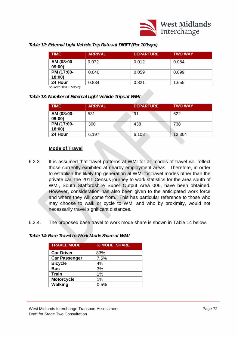
West Midlands Interchange Transport Assessment Page 72 Draft for Stage Two Consultation
Table 12: External Light Vehicle Trip Rates at DIRFT (Per 100sqm)
TIME ARRIVAL DEPARTURE TWO WAY
AM (08:00-09:00)
0.072 0.012 0.084
PM (17:00-18:00)
0.040 0.059 0.099
24 Hour 0.834 0.821 1.655 Source: DIRFT Survey
Table 13: Number of External Light Vehicle Trips at WMI
TIME ARRIVAL DEPARTURE TWO WAY
AM (08:00-09:00)
531 91 622
PM (17:00-18:00)
300 438 738
24 Hour 6,197 6,108 12,304
Mode of Travel
6.2.3. It is assumed that travel patterns at WMI for all modes of travel will reflect those currently exhibited at nearby employment areas. Therefore, in order to establish the likely trip generation at WMI for travel modes other than the private car, the 2011 Census journey to work statistics for the area south of WMI, South Staffordshire Super Output Area 006, have been obtained. However, consideration has also been given to the anticipated work force and where they will come from. This has particular reference to those who may choose to walk or cycle to WMI and who by proximity, would not necessarily travel significant distances.
6.2.4. The proposed base travel to work mode share is shown in Table 14 below.
Table 14: Base Travel to Work Mode Share at WMI
TRAVEL MODE % MODE SHARE
Car Driver 83% Car Passenger 7.5% Bicycle 4% Bus 3% Train 1% Motorcycle 1% Walking 0.5%
West Midlands Interchange Transport Assessment Page 73 Draft for Stage Two Consultation
6.2.5. Due to the geographic nature of the area it can be seen from Table 14 that there is a high car usage by employees travelling to work, with 83% driving alone and 7.5% as car passenger.
6.2.6. The trip rates in Table 12 are primarily private car therefore, as shown in Table 14, cars are 83% of the Non – HGV person trip rate. Factoring this up to 100% provides a Non - HGV person trip rate, this can then be converted to trip rate by travel mode using the travel mode shares in Table 14. This is set out in Table 15 below.
Table 15: External Non – HGV Multi Modal Person Trip Rates (per 100sqm)
TRAVEL MODE
AM IN AM OUT
AM TWO WAY
PM IN PM OUT
PM TWO WAY
DAILY IN
DAILY OUT
DAILY TWO WAY
Train 0.001 0.000 0.001 0.000 0.001 0.001 0.010 0.010 0.020 Bus 0.003 0.000 0.003 0.001 0.002 0.004 0.030 0.030 0.060 Taxi 0.000 0.000 0.000 0.000 0.000 0.000 0.000 0.000 0.000 Motorcycle 0.001 0.000 0.001 0.000 0.001 0.001 0.010 0.010 0.020 Car driver 0.072 0.012 0.084 0.040 0.059 0.099 0.834 0.822 1.656 Car Passenger 0.006 0.001 0.008 0.004 0.005 0.009 0.075 0.074 0.150 Bicycle 0.003 0.001 0.004 0.002 0.003 0.005 0.040 0.040 0.080 Walking 0.000 0.000 0.001 0.000 0.000 0.001 0.005 0.005 0.010
6.2.7. Access to the Site via other sustainable modes of transport including cycle, bus and rail can be provided and this will be promoted within the FWTP measures that will be provided for WMI.
External Heavy Goods Vehicle Trips
6.2.8. As a proportion of HGV trips will originate from and remain within the Site, for operational purposes in transferring cargo from rail to warehouse for example, it is important to disaggregate internal trips and external trips made by HGVs, as such internal trips would not impact on the external highway network.
6.2.9. Through analysis of the ANPR survey data HGVs were monitored, entering and existing each zone of DIRFT to gauge the level of internal and external HGV movements.
West Midlands Interchange Transport Assessment Page 74 Draft for Stage Two Consultation
6.2.10. Based on the surveys undertaken at DIRFT the external HGV trip rates per 100sqm have been calculated and are set out in Table 16 below.
Table 16: External Warehouse Related Heavy Good Vehicle Trip Rates at DIRFT (per 100sqm)
TIME ARRIVAL DEPARTURE TWO WAY
AM (08:00-09:00)
0.017 0.016 0.032
PM (17:00-18:00)
0.017 0.022 0.038
24 Hour 0.382 0.366 0.748
6.2.11. Based on the GFA of WMI being up to 743,200sqm the resulting AM and PM trips are shown in Table 17.
Table 17: External Warehouse Related Heavy Goods Vehicle Trips at WMI
TIME ARRIVAL DEPARTURE TWO WAY
AM (08:00-09:00)
126 119 245
PM (17:00-18:00)
126 164 290
24 Hour 2,839 2,720 5,559
6.2.12. In addition to the above external HGV movements, the intermodal terminal is also expected to generate a number of HGV movements, independent of the warehousing. These relate to the number of trains currently envisaged to serve the rail terminal at WMI. Table 18 sets out the expected external Intermodal HGV trip generation if the predicted 10 trains a day were to serve WMI.
West Midlands Interchange Transport Assessment Page 75 Draft for Stage Two Consultation
Table 18: External Intermodal related Heavy Goods Vehicle Trips
TIME ARRIVAL DEPARTURE TWO WAY
AM (08:00-09:00)
15 25 41
PM (17:00-18:00)
24 17 41
24 Hour 395 364 759
6.2.13. Combining the external warehouse related HGV trips and the external intermodal HGV trips, the total external HGV trip generation is shown in Table 19 below.
Table 19: Total External Heavy Good Vehicle Trips
TIME ARRIVAL DEPARTURE TWO WAY
AM (08:00-09:00) 141 144 285
PM (17:00-18:00) 150 181 331
24 Hour 3,234 3,084 6,318
6.3. Trip Distribution
6.3.1. So an assessment can be made on the direction of traffic travelling to and from WMI, a distribution model for both light vehicles and HGVs has been undertaken.
6.3.2. The trip distribution methodology for traffic generated by WMI is set out in Technical Note 14, (shown in Appendix M). The methodologies outlined in this technical note were discussed and agreed with HE and SCC as the most appropriate method of trip distribution for both vehicle classes.
West Midlands Interchange Transport Assessment Page 76 Draft for Stage Two Consultation
Light Vehicle Trips Distribution from WMI
6.3.3. Two distribution methodologies for light vehicles were examined including using Journey to Work Census Data and a Gravity Model. Journey to Work Census Data was analysed for the Middle Layer Super Output Area (MSOA) South Staffordshire 006. Whilst the majority of the Site is in MSOA South Staffordshire 001, it was not deemed appropriate to use as it does not include any significant employment areas, where as 006 contains part of the Site in addition to the Four Ashes and SI Group employment areas.
6.3.4. It was concluded that as a large new employer, it is unlikely that the employee distribution will match the existing journey to work patterns of 006; therefore, an extended gravity model was produced based on the potential catchment areas of employees for WMI.
6.3.5. Discussions have been undertaken with socio-economic consultants to ensure a robust approach is taken, based on the economically active residents in the catchment.
6.3.6. The final proposed light vehicle (employee) distribution is set out in Table 20.
Table 20: Light Vehicle (Employee) Distribution – Gravity Model
AREA DISTRIBUTION (%)
Birmingham (Part Of) 6.61% Cannock Chase 8.81% Dudley 2.60% Litchfield 8.29% Sandwell 8.49% Shropshire 3.66% South Staffordshire 18.20% Stafford 5.13% Telford and Wrekin 6.10% Walsall 11.38% Wolverhampton 12.08% Stoke-on-Trent 5.17% Staffordshire Moorlands 0.53% Newcastle-under-Lyme 1.70% East Staffordshire 1.26% Total 100%
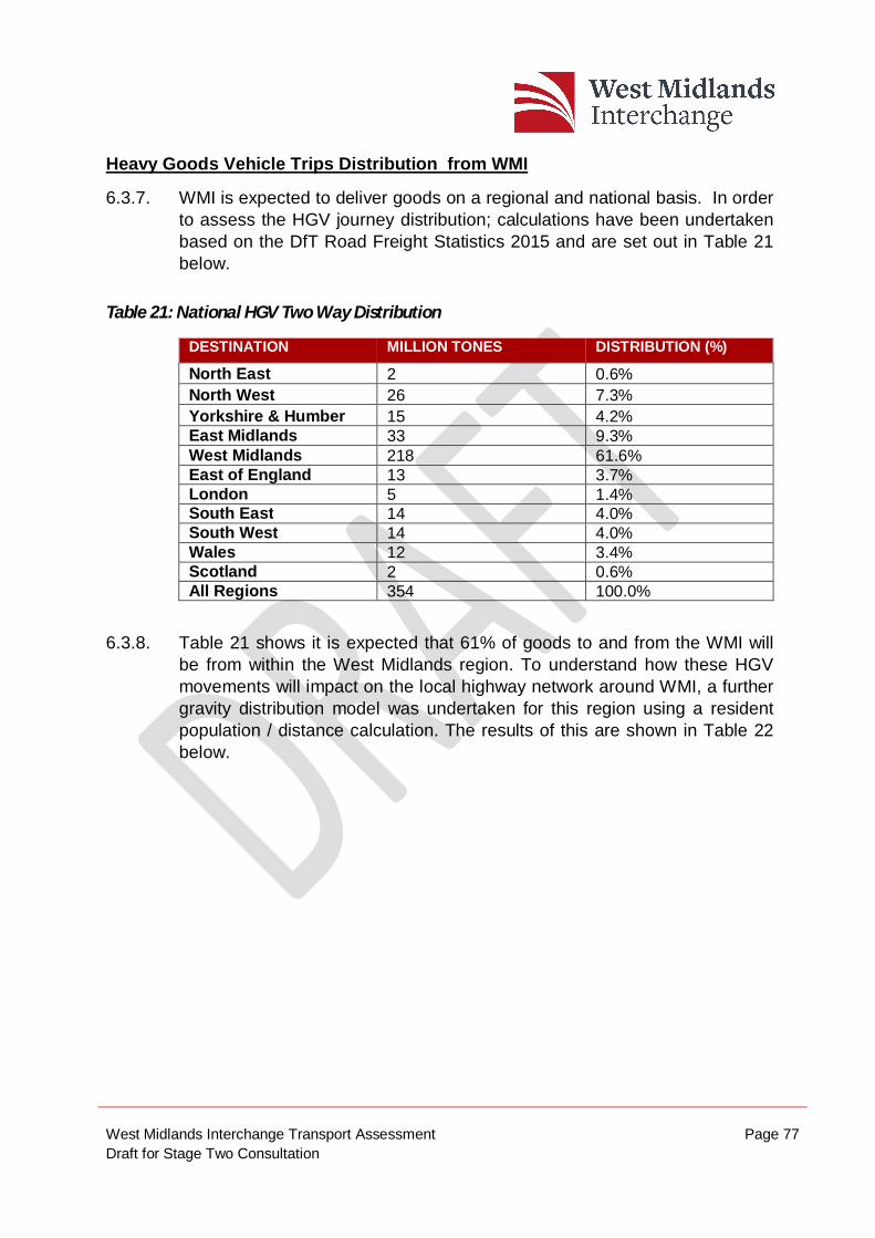
West Midlands Interchange Transport Assessment Page 77 Draft for Stage Two Consultation
Heavy Goods Vehicle Trips Distribution from WMI
6.3.7. WMI is expected to deliver goods on a regional and national basis. In order to assess the HGV journey distribution; calculations have been undertaken based on the DfT Road Freight Statistics 2015 and are set out in Table 21 below.
Table 21: National HGV Two Way Distribution
DESTINATION MILLION TONES DISTRIBUTION (%)
North East 2 0.6% North West 26 7.3% Yorkshire & Humber 15 4.2% East Midlands 33 9.3% West Midlands 218 61.6% East of England 13 3.7% London 5 1.4% South East 14 4.0% South West 14 4.0% Wales 12 3.4% Scotland 2 0.6% All Regions 354 100.0%
6.3.8. Table 21 shows it is expected that 61% of goods to and from the WMI will be from within the West Midlands region. To understand how these HGV movements will impact on the local highway network around WMI, a further gravity distribution model was undertaken for this region using a resident population / distance calculation. The results of this are shown in Table 22 below.
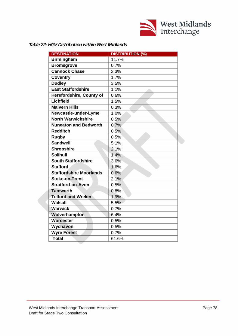
West Midlands Interchange Transport Assessment Page 78 Draft for Stage Two Consultation
Table 22: HGV Distribution within West Midlands
DESTINATION DISTRIBUTION (%) Birmingham 11.7% Bromsgrove 0.7% Cannock Chase 3.3% Coventry 1.7% Dudley 3.5% East Staffordshire 1.1% Herefordshire, County of 0.6% Lichfield 1.5% Malvern Hills 0.3% Newcastle-under-Lyme 1.0% North Warwickshire 0.5% Nuneaton and Bedworth 0.7% Redditch 0.5% Rugby 0.5% Sandwell 5.1% Shropshire 2.1% Solihull 1.4% South Staffordshire 3.6% Stafford 1.6% Staffordshire Moorlands 0.6% Stoke-on-Trent 2.1% Stratford-on-Avon 0.5% Tamworth 0.8% Telford and Wrekin 1.9% Walsall 5.5% Warwick 0.7% Wolverhampton 6.4% Worcester 0.5% Wychavon 0.5% Wyre Forest 0.7% Total 61.6%
West Midlands Interchange Transport Assessment Page 79 Draft for Stage Two Consultation
6.4. Summary
6.4.1. A number of MCC and ANPR surveys were undertaken at DIRFT, to ascertain a trip rate for light vehicle and HGV movements generated by WMI. DIRFT was selected due to it being a comparable SRFI with WMI and located in the Midlands area.
6.4.2. Trip distribution has been calculated using gravity models for both light vehicles and HGVs. The results of the light vehicle distribution have been correlated with the local labour force profile to ensure the distribution is realistic. The majority of HGV trips will travel to / from the local area (with 61% of HGV movements remaking in the West Midlands).
West Midlands Interchange Transport Assessment Page 80 Draft for Stage Two Consultation
7. MODELLING BACKGROUND 7.1. Preamble
7.1.1. This chapter summaries the strategic traffic modelling approach adopted to assess the highway implications of WMI.
7.1.2. The modelling platforms utilised are the M54 / M6 / M6 Toll Link Road SATURN Model (M54/M6SM) and the South Staffordshire VISSIM Model (SSVM). The M54/M6SM was developed by Atkins on behalf of Highways England with a 2012 Base Year and forecast years of 2021 and 2036. The SSVM has been developed by Systra on behalf of Highways England with a Base Year of 2015.
7.1.3. In order to provide a policy compliant assessment in accordance with Circular 02/2013, it has been agreed with both HE and SCC that it is necessary to undertake capacity analysis of the operation of the highway network at the year of opening of the scheme, which is 2021. This future year assessment at 2021 allows for the full delivery of development floor area of WMI in accordance with Circular 02/2013 and it is this future year assessment that is utilised in order to determine any highway mitigation that may be required as a consequence of the Proposed Development.
7.1.4. Both Atkins and Systra were commissioned separately to undertake further modelling on behalf of WSP in order to assess the implications of the Proposed Development with the agreement of HE and SCC.
7.1.5. M54/M6SM has been used to distribute WMI traffic to the wider highway network, with HE’s SSVM then distributing it across the local highway network, more accurately reflecting the local conditions. The SSVM is then used as a tool to assess the operation of the highway network.
7.1.6. It was agreed with the Highway Authority’s that the area covered by the SSVM should form the assessment cordon to be considered in order to identify the highway implications of WMI.
West Midlands Interchange Transport Assessment Page 81 Draft for Stage Two Consultation
7.1.7. In the absence of an announcement of the preferred route of the M54/M6/M6 Toll link, it has been agreed with the Highway Authority’s that modelling at this stage should not consider a 2036 forecast year. Once the announcement of the preferred route has been made then this additional forecast year assessment of 2036 can be undertaken. In the event that a preferred route has not been announced at the time of the submission of the WMI Development Consent Order, an alternative assessment approach that accounts for the M54 / M6 / M6 Toll link road will be agreed with the Highway Authority’s. Given that this scheme is identified as a committed highway infrastructure scheme by Highways England, it is necessary to take its introduction into account when considering the highway implications of WMI.
7.1.8. Therefore, for each traffic model platform, two separate scenarios have been prepared. These are: -
2021 Do Minimum (including committed development); and
2021 Do Something (including committed development and the WMI Proposed Development).
7.1.9. For descriptive purposes, the 2021 Do Minimum scenario is referred to as 2021 without WMI, whilst the 2021 Do Something, is referred to as 2021with WMI.
7.2. M54 / M6 / M6 Toll Link Saturn Model
7.2.1. The M54/M6SM has been prepared by Atkins acting for Highways England. The SATURN model network is shown in Diagram 7.1 below.
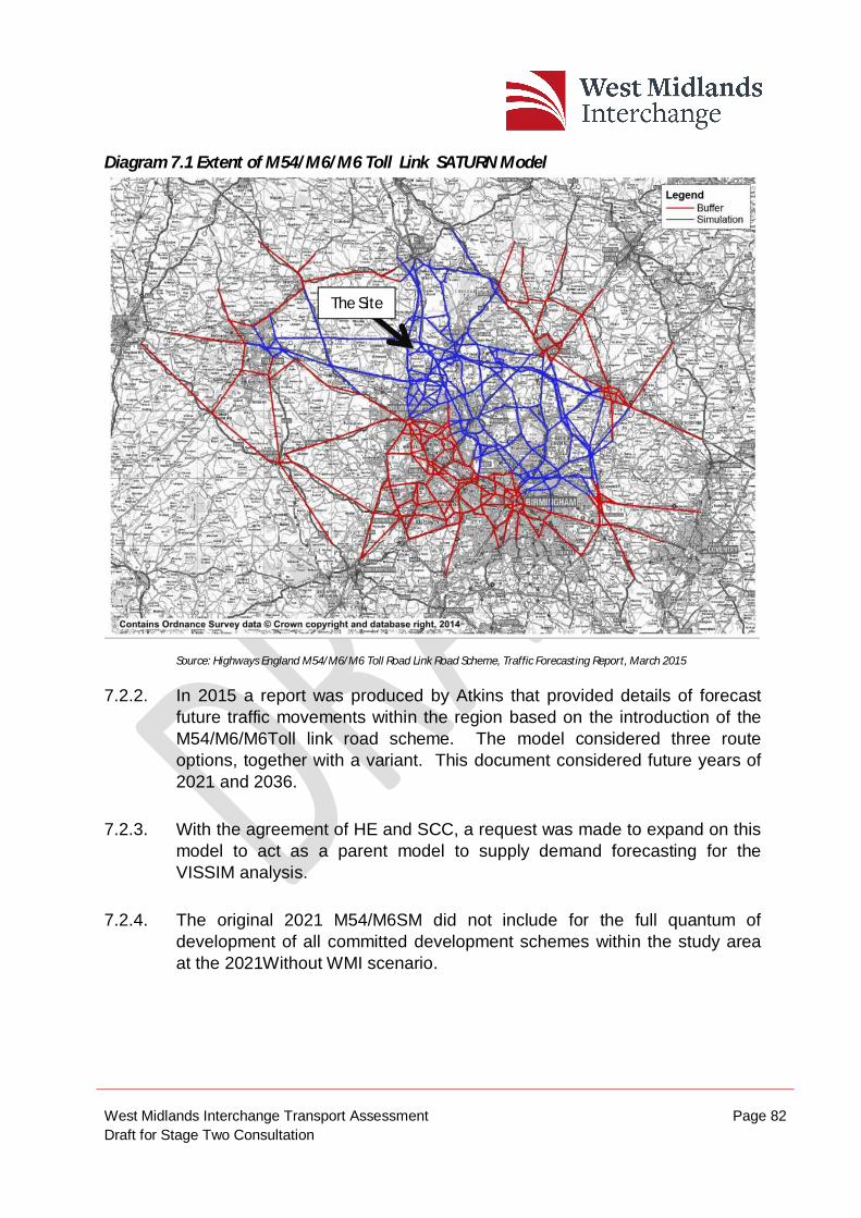
West Midlands Interchange Transport Assessment Page 82 Draft for Stage Two Consultation
Diagram 7.1 Extent of M54/M6/M6 Toll Link SATURN Model
Source: Highways England M54/M6/M6 Toll Road Link Road Scheme, Traffic Forecasting Report, March 2015
7.2.2. In 2015 a report was produced by Atkins that provided details of forecast future traffic movements within the region based on the introduction of the M54/M6/M6Toll link road scheme. The model considered three route options, together with a variant. This document considered future years of 2021 and 2036.
7.2.3. With the agreement of HE and SCC, a request was made to expand on this model to act as a parent model to supply demand forecasting for the VISSIM analysis.
7.2.4. The original 2021 M54/M6SM did not include for the full quantum of development of all committed development schemes within the study area at the 2021Without WMI scenario.
The Site
West Midlands Interchange Transport Assessment Page 83 Draft for Stage Two Consultation
7.2.5. At the request of the Highway Authority’s, the extent of cumulative schemes included within the model was expanded in order to account for further schemes that have been consented since the preparation of the original 2021 M54/M6SM. These additional cumulative schemes are: -
Ward Street, Ettingshall (650 dwellings);
Bilston Urban Village (478 dwellings);
Watery Lane, Codsall (180 dwellings);
Cley Road, Cannock (34,560 sqm B8 floor space); and
Kingswood Lakeside, Blakey Way (12,454 sqm B8 floor space).
7.2.6. These sites are located beyond the Cumulative search area as agreed with SSDC in respect of the Environmental Statement, but are located within the Administrative Districts surrounding the Site. In accordance with Circular 02/2013, all development consents within the vicinity of the Site should be included within Baseline traffic flow. On this basis and as required by the Highway Authority’s, they have been included within the strategic traffic modelling that has been undertaken.
7.2.7. In relation to the Bericote committed development scheme, a further consent was secured during 2016 and the associated development traffic was not included within the original M6/M54SM. Whilst this site does form part of the Cumulative Site search area, it was necessary to include for the further traffic associated with the additional consent within the traffic modelling.
7.2.8. Finally, the original 2021 M54/M6SM included allowances for strategic improvements to the A449 corridor. These improvements are not committed therefore, these infrastructure alterations to the highway network have been removed from the model.
7.2.9. In respect of the 2021 with WMI scenario, WMI development traffic has been included within the model, based upon the development traffic distribution agreed with the Highway Authority’s.
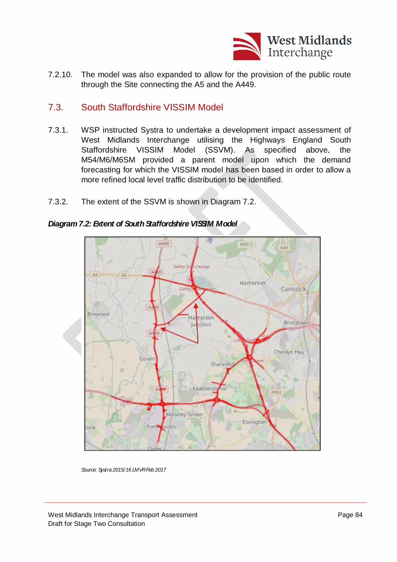
West Midlands Interchange Transport Assessment Page 84 Draft for Stage Two Consultation
7.2.10. The model was also expanded to allow for the provision of the public route through the Site connecting the A5 and the A449.
7.3. South Staffordshire VISSIM Model
7.3.1. WSP instructed Systra to undertake a development impact assessment of West Midlands Interchange utilising the Highways England South Staffordshire VISSIM Model (SSVM). As specified above, the M54/M6/M6SM provided a parent model upon which the demand forecasting for which the VISSIM model has been based in order to allow a more refined local level traffic distribution to be identified.
7.3.2. The extent of the SSVM is shown in Diagram 7.2.
Diagram 7.2: Extent of South Staffordshire VISSIM Model
Source: Systra 2015/16 LMVR Feb 2017
West Midlands Interchange Transport Assessment Page 85 Draft for Stage Two Consultation
7.3.3. The model commissioned involved updating the 2015 Base Year SSVM to include WMI development traffic, and public access through the internal road connecting the A449 and A5.
7.3.4. The original SSVM was updated by Systra on behalf of WSP to address the following for the 2021 Without WMI scenario: -
Provision of validated queue lengths at A449 / Station Drive;
Provision of validated queue lengths at A5 / Vicarage Road; and
Identification of traffic travelling through both ends of Station Drive and Vicarage Road.
7.3.5. A Local Model Validation Report was carried out in February 2017 (Shown in Appendix N) detailing these updates to the original SSVM demonstrating that the SSVM was developed in accordance with the Highways England and Department for Transport modelling guidelines.
7.3.6. In respect of the 2021 With WMI scenario, the VISSIM model was also expanded in order to reflect the highway infrastructure that would be delivered by WMI, as described in more detail in Chapter 5 together with the associated traffic generation of the Proposed Development. In summary, the following highway infrastructure assumptions were included within the expanded model:
Proposed Site access junctions with the A5, A449 and Vicarage Road;
Provision of a public route through the Site between the A5 and the A449.
Removal of the right turn from the A449 to Station Drive;
Altering Crateford Lane to one way only in an east bound direction;
West Midlands Interchange Transport Assessment Page 86 Draft for Stage Two Consultation
7.3.7. It should be noted that at the time of SSVM being run to account for WMI, no allowance had been included for the influence of the internal non adopted route through the Site connecting to Vicarage Road. As this route will not be offered for adoption, it will not be open to the public at all times therefore, in order to present a robust assessment; no allowance for its inclusion has been made within the SSVM. However, HE have requested that this route be included within a further iteration of the model. In addition, SCC have requested that all future iterations of the SSVM models also include for the ban of HGV movements through Penkridge as per the proposed WMI HGV routing ban. This further modelling will be undertaken post Stage Two Consultation.
West Midlands Interchange Transport Assessment Page 87 Draft for Stage Two Consultation
8. HIGHWAY IMPACT ANALYSIS 8.1.1. This chapter describes the impacts of the Proposed Development on the
strategic and local highway network that serves the Site. This section therefore reports on key variables in order to consider the highway implications of the Proposed Development and to demonstrate that the highway works proposed to be delivered by way of the DCO are sufficient to mitigate changes in traffic. This section will therefore report on, the following points:
Traffic flows;
Journey Times;
Vehicle Speeds; and
Queue Lengths.
8.1.2. As specified in Chapter 7, it has been agreed with HE and SCC that the assessment of the impact of the proposed West Midlands Interchange should be undertaken using the detailed SSVM with the demand forecasting being supplied from the 2021 M54/M6SM.
8.1.3. Whilst the SSVM provides an assessment to be made across a wide area, for the purpose of this document, the immediate road network around the Site will be defined as the study area and will include the following six existing junctions, as shown in Figure 8.
M6 Junction 12
Gailey Roundabout (A5/A449)
A449/Gravelly Way/Crateford Lane/Site Access
A449/Four Ashes Road/Station Drive
A5/Vicarage Road
West Midlands Interchange Transport Assessment Page 88 Draft for Stage Two Consultation
Vicarage Road/Straight Mile
8.1.4. In addition, the operation of the proposed Site access junctions with the A5 and Vicarage Road will also be considered.
8.2. VISSIM Network Performance
8.2.1. Systra have provided details of the output of the VISSIM modelling output that has been undertaken in order to account for WMI. The main results, which compared the 2021 without WMI and 2021 with WMI scenarios confirm the following: -, include:
Average travel time stayed the same in both the AM and PM periods;
Average speed decreased from 71kph to 70kph in AM and 69kph to 67kph in the PM
Average delay increased from 54 seconds to 56 seconds in the AM and from 70 to 77 seconds in PM
Local Journey Time Results
8.2.2. In the immediate vicinity of WMI, eight routes were modelled through the SSVM to identify information on journey times on these links.
8.2.3. The comparison of journey times between the 2021 Without WMI and 2021 With WMI scenarios during the AM and PM peak hours is shown in Table 23 below.
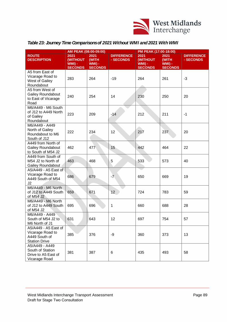
West Midlands Interchange Transport Assessment Page 89 Draft for Stage Two Consultation
Table 23: Journey Time Comparisons of 2021 Without WMI and 2021 With WMI
AM PEAK (08:00-09:00) PM PEAK (17:00-18:00) ROUTE DESCRIPTION
2021 (WITHOUT WMI) - SECONDS
2021 (WITH WMI) - SECONDS
DIFFERENCE - SECONDS
2021 (WITHOUT WMI) - SECONDS
2021 (WITH WMI) - SECONDS
DIFFERENCE - SECONDS
A5 from East of Vicarage Road to West of Gailey Roundabout
283 264 -19 264 261 -3
A5 from West of Gailey Roundabout to East of Vicarage Road
240 254 14 230 250 20
M6/A449 - M6 South of J12 to A449 North of Gailey Roundabout
223 209 -14 212 211 -1
M6/A449 - A449 North of Gailey Roundabout to M6 South of J12
222 234 12 217 237 20
A449 from North of Gailey Roundabout to South of M54 J2
462 477 15 442 464 22
A449 from South of M54 J2 to North of Gailey Roundabout
463 468 5 533 573 40
A5/A449 - A5 East of Vicarage Road to A449 South of M54 J2
686 679 -7 650 669 19
M6/A449 - M6 North of J12 to A449 South of M54 J2
659 671 12 724 783 59
M6/A449 - M6 North of J12 to A449 South of M54 J2
695 696 1 660 688 28
M6/A449 - A449 South of M54 J2 to M6 North of J1
631 643 12 697 754 57
A5/A449 - A5 East of Vicarage Road to A449 South of Station Drive
385 376 -9 360 373 13
A5/A449 - A449 South of Station Drive to A5 East of Vicarage Road
381 387 6 435 493 58
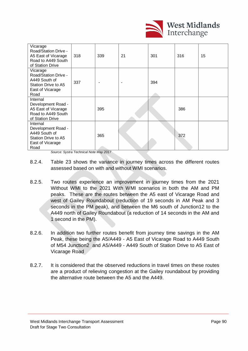
West Midlands Interchange Transport Assessment Page 90 Draft for Stage Two Consultation
Vicarage Road/Station Drive - A5 East of Vicarage Road to A449 South of Station Drive
318 339 21 301 316 15
Vicarage Road/Station Drive - A449 South of Station Drive to A5 East of Vicarage Road
337 - - 394
Internal Development Road - A5 East of Vicarage Road to A449 South of Station Drive
395 386
Internal Development Road - A449 South of Station Drive to A5 East of Vicarage Road
365 372
Source: Systra Technical Note May 2017
8.2.4. Table 23 shows the variance in journey times across the different routes assessed based on with and without WMI scenarios.
8.2.5. Two routes experience an improvement in journey times from the 2021 Without WMI to the 2021 With WMI scenarios in both the AM and PM peaks. These are the routes between the A5 east of Vicarage Road and west of Gailey Roundabout (reduction of 19 seconds in AM Peak and 3 seconds in the PM peak), and between the M6 south of Junction12 to the A449 north of Gailey Roundabout (a reduction of 14 seconds in the AM and 1 second in the PM).
8.2.6. In addition two further routes benefit from journey time savings in the AM Peak, these being the A5/A449 - A5 East of Vicarage Road to A449 South of M54 Junction2 and A5/A449 - A449 South of Station Drive to A5 East of Vicarage Road
8.2.7. It is considered that the observed reductions in travel times on these routes are a product of relieving congestion at the Gailey roundabout by providing the alternative route between the A5 and the A449.
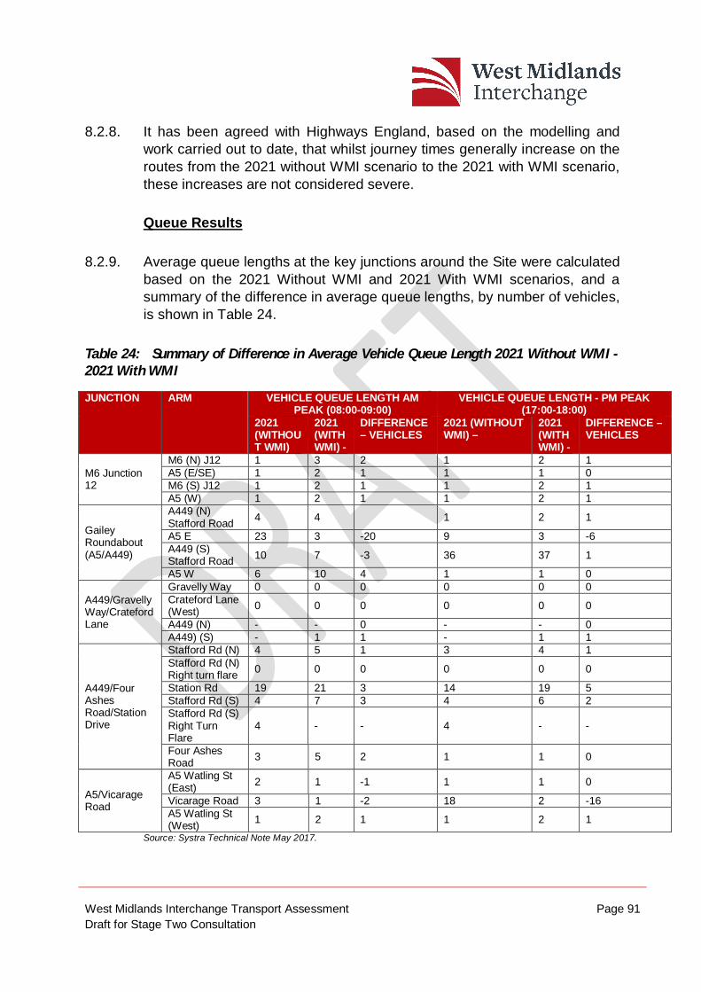
West Midlands Interchange Transport Assessment Page 91 Draft for Stage Two Consultation
8.2.8. It has been agreed with Highways England, based on the modelling and work carried out to date, that whilst journey times generally increase on the routes from the 2021 without WMI scenario to the 2021 with WMI scenario, these increases are not considered severe.
Queue Results
8.2.9. Average queue lengths at the key junctions around the Site were calculated based on the 2021 Without WMI and 2021 With WMI scenarios, and a summary of the difference in average queue lengths, by number of vehicles, is shown in Table 24.
Table 24: Summary of Difference in Average Vehicle Queue Length 2021 Without WMI - 2021 With WMI
JUNCTION
ARM VEHICLE QUEUE LENGTH AM PEAK (08:00-09:00)
VEHICLE QUEUE LENGTH - PM PEAK (17:00-18:00)
2021 (WITHOUT WMI)
2021 (WITH WMI) -
DIFFERENCE – VEHICLES
2021 (WITHOUT WMI) –
2021 (WITH WMI) -
DIFFERENCE – VEHICLES
M6 Junction 12
M6 (N) J12 1 3 2 1 2 1 A5 (E/SE) 1 2 1 1 1 0 M6 (S) J12 1 2 1 1 2 1 A5 (W) 1 2 1 1 2 1
Gailey Roundabout (A5/A449)
A449 (N) Stafford Road 4 4 1 2 1
A5 E 23 3 -20 9 3 -6 A449 (S) Stafford Road 10 7 -3 36 37 1
A5 W 6 10 4 1 1 0
A449/Gravelly Way/Crateford Lane
Gravelly Way 0 0 0 0 0 0 Crateford Lane (West) 0 0 0 0 0 0
A449 (N) - - 0 - - 0 A449) (S) - 1 1 - 1 1
A449/Four Ashes Road/Station Drive
Stafford Rd (N) 4 5 1 3 4 1 Stafford Rd (N) Right turn flare 0 0 0 0 0 0
Station Rd 19 21 3 14 19 5 Stafford Rd (S) 4 7 3 4 6 2 Stafford Rd (S) Right Turn Flare
4 - - 4 - -
Four Ashes Road 3 5 2 1 1 0
A5/Vicarage Road
A5 Watling St (East) 2 1 -1 1 1 0
Vicarage Road 3 1 -2 18 2 -16 A5 Watling St (West) 1 2 1 1 2 1
Source: Systra Technical Note May 2017.
West Midlands Interchange Transport Assessment Page 92 Draft for Stage Two Consultation
8.2.10. While there is an increase in average queue length on all arms of the M6 Junction 12, these increases are only 1 or 2 vehicles and are not considered to represent a significant impact. Even with the development average queues at M6 Junction 12 do not exceed 3 vehicles on any arm.
8.2.11. The addition of the internal road through the Site has a positive impact on the Gailey Roundabout, specifically the A5 east arm which sees a reduction in queue length of 20 and 6 vehicles in the AM and PM peak hours respectively; down to only 3 vehicles in both peaks. The queue on the A449 south also reduces in the AM peak, by 3 vehicles but increases by 1 in the PM peak. However, the A5 west arm sees an increase in queue length of 4 vehicles to 10 during the AM peak period but no change to the 1 vehicle queue during the PM peak.
8.2.12. In addition, benefit in reduced queuing is also seen at the junction of A5/Vicarage Road with a reduction of 2 and 16 vehicles on the vicarage Road arm in the in the AM and PM peak hours respectively. This can be attributed to the banned right turn at the A449 / Station Drive junction preventing rat runners from using this route.
8.2.13. There are some minor increases in queues at the A449 / Station Road junction but these are not considered significant. The average queues on the A449 with the development do not exceed 7 vehicles On Station Drive the average queues are longer (21 and 19 but are predicted to clear during each cycle of the signals.
8.3. Site Access Junctions
8.3.1. The output of the SSVM indicates that the proposed site access junctions would operate without congestion issues. The Vicarage Road junction is shown to operate without queues. In respect of the A5 access, average queue lengths are shown to be low, being limited to four vehicles on the A5 west arm during the PM peak hour. Any average queues shown at the A449 access roundabout are shown to be low.
West Midlands Interchange Transport Assessment Page 93 Draft for Stage Two Consultation
8.3.2. In respect of the access to the Intermodal Terminal, comment has been made by HE as to the proximity of this junction to the A449 roundabout. This concerns the potential for right turning traffic to block back towards the A449 roundabout. Having reviewed the average queue values from the SSVM, it can be seen that queuing does not occur at the access to the Intermodal Terminal during peak times. Therefore, traffic would not block from the Intermodal Terminal access to the A449 confirming that there would not be any issues within the Site roads that may comprise the operation of the SRN.
8.3.3. Overall, this demonstrates that the access strategy to serve WMI will operate satisfactorily and will not impact upon the operation of the existing highway network.
8.4. SATURN & VISSIM Traffic Flow Output
8.4.1. Traffic data has been obtained from the two modelling platforms. Provided at Appendices O and P are traffic flow diagrams. The diagrams in Appendix O show the wider area and includes mainly data from the M54/M6SM. The diagrams in Appendix P show the local area and includes data exclusively from the SSVM.
8.4.2. The wider area flow diagrams show the changes in traffic flows during the AM (08:00-0900) and PM peak hours (17:00-18:00) when comparing the 2021 Without WMI with the 2021 With WMI scenarios.
8.4.3. The local area flow diagrams show the changes in traffic flows during the AM (08:00-0900) and PM peak hours (17:00-18:00) when comparing the 2021 Without WMI with the 2021 With WMI scenarios.
8.4.4. A further set of turning movement flows diagrams have also been produced for the local area and these are included in Appendix Q.
8.4.5. As previously explained, HE’s M54/M6SM distributes WMI traffic to the wider highway network, with HE’s SSVM then distributing it across the local highway network, more accurately reflecting the local conditions. Therefore, in terms of the distribution of traffic upon the local highway network, the SSVM provides the most accurate method of identifying traffic changes and the resulting conditions arising from the Proposed Development.
West Midlands Interchange Transport Assessment Page 94 Draft for Stage Two Consultation
8.4.6. At the interface of the two HE models around the A5, between Junction12 and Cannock, there is a difference in traffic flow, specifically between the flows reported along Vicarage Road and Straight Mile / Four Crosses junction on the A5.
8.4.7. This difference between the models means that the reported impact on the two roads is slightly different in the south west direction on these roads. Although both models do not show Straight Mile is used by any development traffic the M54/M6SM model records small increases of 68 and 83 vehicles per hour during the AM and PM peak hours respectively. As the SSVM does not include the whole of Straight Mile, these increases in traffic are reflected on Vicarage Road instead. Hence if flows of up to 68 and 83 vehicles per hour during the AM and PM peak hours do use Straight Mile and Four Crosses Lane then the increased flows on Vicarage Road should reduce by a similar volume.
8.4.8. The model outputs also confirm that traffic associated with the Proposed Development is not predicted to use local routes to the north of the A5 at the junction with Four Crosses Lane, for example through the Village of Hatherton.
Link Flows
8.4.9. From the VISSIM model, local link flows around the Site can be obtained for both the 2021 with and without WMI scenarios to assess the impact of the WMI development on traffic flows.
8.4.10. A comparison has been made between 2021 Without WMI and 2021 With WMI for AM (08:00 – 09:00) and PM (17:00-18:00) peaks and is shown in Table 25.
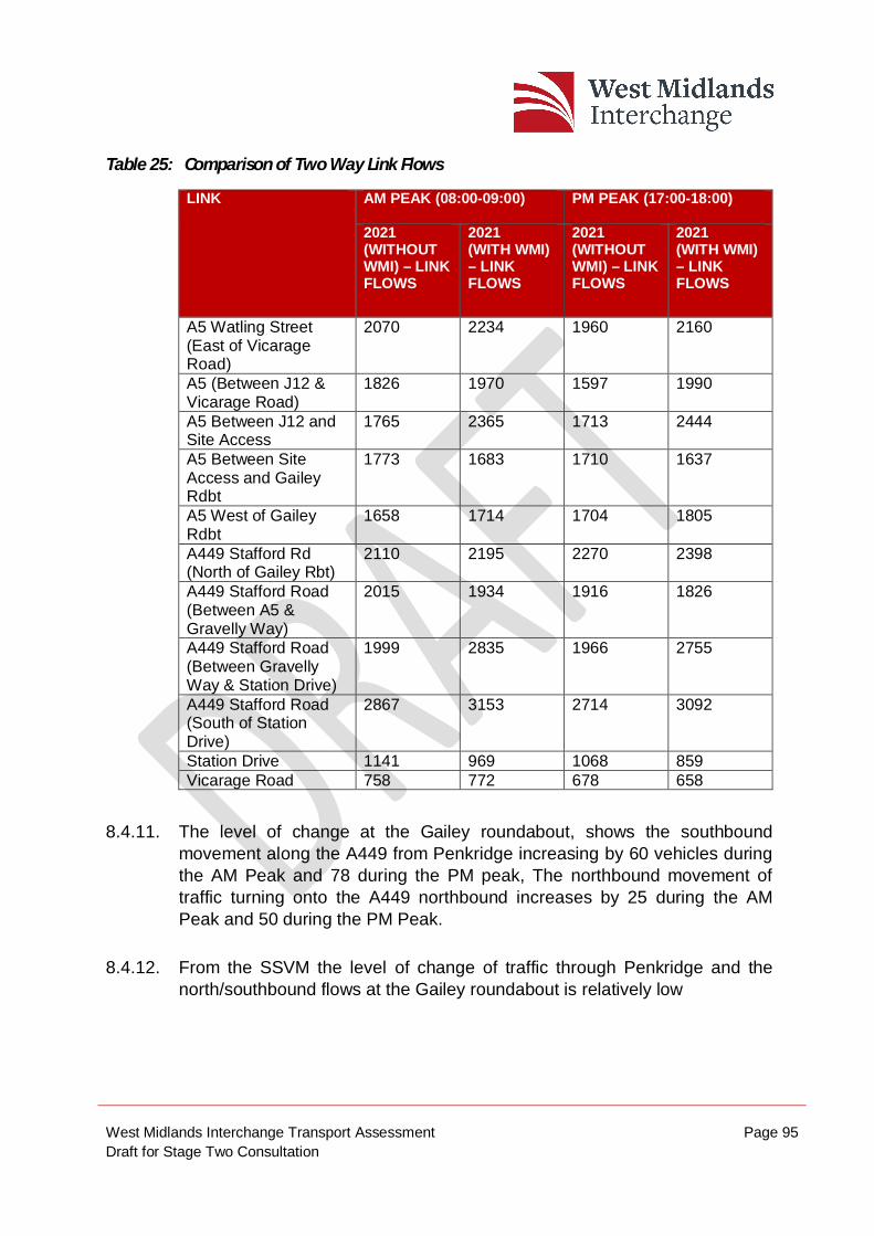
West Midlands Interchange Transport Assessment Page 95 Draft for Stage Two Consultation
Table 25: Comparison of Two Way Link Flows
LINK
AM PEAK (08:00-09:00) PM PEAK (17:00-18:00)
2021 (WITHOUT WMI) – LINK FLOWS
2021 (WITH WMI) – LINK FLOWS
2021 (WITHOUT WMI) – LINK FLOWS
2021 (WITH WMI) – LINK FLOWS
A5 Watling Street (East of Vicarage Road)
2070 2234 1960 2160
A5 (Between J12 & Vicarage Road)
1826 1970 1597 1990
A5 Between J12 and Site Access
1765 2365 1713 2444
A5 Between Site Access and Gailey Rdbt
1773 1683 1710 1637
A5 West of Gailey Rdbt
1658 1714 1704 1805
A449 Stafford Rd (North of Gailey Rbt)
2110 2195 2270 2398
A449 Stafford Road (Between A5 & Gravelly Way)
2015 1934 1916 1826
A449 Stafford Road (Between Gravelly Way & Station Drive)
1999 2835 1966 2755
A449 Stafford Road (South of Station Drive)
2867 3153 2714 3092
Station Drive 1141 969 1068 859 Vicarage Road 758 772 678 658
8.4.11. The level of change at the Gailey roundabout, shows the southbound movement along the A449 from Penkridge increasing by 60 vehicles during the AM Peak and 78 during the PM peak, The northbound movement of traffic turning onto the A449 northbound increases by 25 during the AM Peak and 50 during the PM Peak.
8.4.12. From the SSVM the level of change of traffic through Penkridge and the north/southbound flows at the Gailey roundabout is relatively low
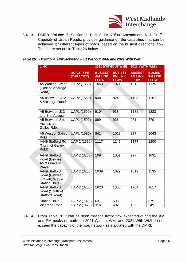
West Midlands Interchange Transport Assessment Page 96 Draft for Stage Two Consultation
8.4.13. DMRB Volume 5 Section 1 Part 3 TA 79/99 Amendment No1 Traffic Capacity of Urban Roads, provides guidance on the capacities that can be achieved for different types of roads, based on the busiest directional flow. These are set out in Table 26 below.
Table 26: Directional Link Flows for 2021 Without WMI and 2021 With WMI
LINK
2021 (WITHOUT WMI) 2021 (WITH WMI)
ROAD TYPE (CAPACITY)
BUSIEST AM LINK FLOW
BUSIEST PM LINK FLOW
BUSIEST AM LINK FLOW
BUSIEST PM LINK FLOW
A5 Watling Street (East of Vicarage Road)
UAP2 (1550) 1069 1071 1016 1175
A5 (Between J12 & Vicarage Road
UAP2 (1550) 938 824 1108 1157
A5 Between J12 and Site Access
UAP1 (1590) 910 938 1185 1283
A5 Between Site Access and Gailey Rdbt
UAP1 (1590) 899 936 931 870
A5 West of Gailey Rdbt
UAP1 (1590) 841 1013 877 1063
A449 Stafford Rd (North of Gailey Rdbt)
UAP 2 (1550) 1117 1146 1177 1200
A449 Stafford Road (Between A5 & Gravelly Way)
UAP 2 (3200) 1094 1051 977 1031
A449 Stafford Road (Between Gravelly Way & Station Drive)
UAP 2 (3200) 1039 1029 1519 1535
A449 Stafford Road (South of Stafford Road)
UAP 2 (3200) 1620 1360 1704 1617
Station Drive UAP 2 (1020) 631 593 632 675 Vicarage Road UAP 2 (1470) 316 402 439 349
8.4.14. From Table 26 it can be seen that the traffic flow expected during the AM and PM peaks on both the 2021 Without WMI and 2021 With WMI do not exceed the capacity of the road network as stipulated with the DMRB.
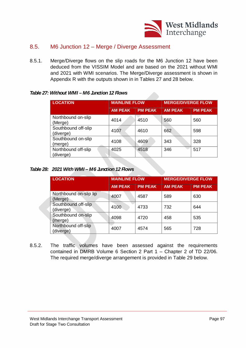
West Midlands Interchange Transport Assessment Page 97 Draft for Stage Two Consultation
8.5. M6 Junction 12 – Merge / Diverge Assessment
8.5.1. Merge/Diverge flows on the slip roads for the M6 Junction 12 have been deduced from the VISSIM Model and are based on the 2021 without WMI and 2021 with WMI scenarios. The Merge/Diverge assessment is shown in Appendix R with the outputs shown in in Tables 27 and 28 below.
Table 27: Without WMI – M6 Junction 12 Flows
LOCATION MAINLINE FLOW MERGE/DIVERGE FLOW
AM PEAK PM PEAK AM PEAK PM PEAK Northbound on-slip (Merge) 4014 4510 560 560
Southbound off-slip (diverge) 4107 4610 662 598
Southbound on-slip (merge) 4108 4609 343 328
Northbound off-slip (diverge)
4025 4518 346 517
Table 28: 2021 With WMI – M6 Junction 12 Flows
LOCATION MAINLINE FLOW MERGE/DIVERGE FLOW
AM PEAK PM PEAK AM PEAK PM PEAK Northbound on-slip lip (Merge) 4007 4587 589 630
Southbound off-slip (diverge) 4100 4733 732 644
Southbound on-slip (merge) 4098 4720 458 535
Northbound off-slip (diverge) 4007 4574 565 728
8.5.2. The traffic volumes have been assessed against the requirements contained in DMRB Volume 6 Section 2 Part 1 – Chapter 2 of TD 22/06. The required merge/diverge arrangement is provided in Table 29 below.
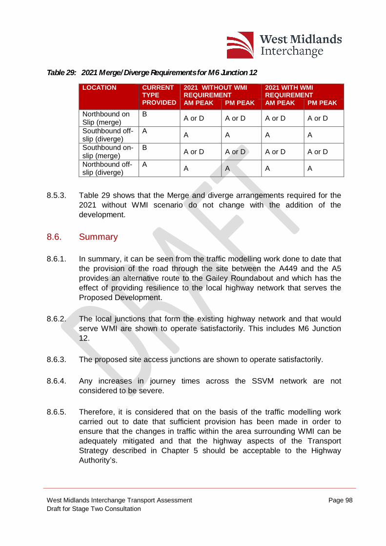
West Midlands Interchange Transport Assessment Page 98 Draft for Stage Two Consultation
Table 29: 2021 Merge/Diverge Requirements for M6 Junction 12
LOCATION CURRENT TYPE PROVIDED
2021 WITHOUT WMI REQUIREMENT
2021 WITH WMI REQUIREMENT
AM PEAK PM PEAK AM PEAK PM PEAK Northbound on Slip (merge)
B A or D A or D A or D A or D
Southbound off-slip (diverge)
A A A A A
Southbound on-slip (merge)
B A or D A or D A or D A or D
Northbound off-slip (diverge)
A A A A A
8.5.3. Table 29 shows that the Merge and diverge arrangements required for the 2021 without WMI scenario do not change with the addition of the development.
8.6. Summary
8.6.1. In summary, it can be seen from the traffic modelling work done to date that the provision of the road through the site between the A449 and the A5 provides an alternative route to the Gailey Roundabout and which has the effect of providing resilience to the local highway network that serves the Proposed Development.
8.6.2. The local junctions that form the existing highway network and that would serve WMI are shown to operate satisfactorily. This includes M6 Junction 12.
8.6.3. The proposed site access junctions are shown to operate satisfactorily.
8.6.4. Any increases in journey times across the SSVM network are not considered to be severe.
8.6.5. Therefore, it is considered that on the basis of the traffic modelling work carried out to date that sufficient provision has been made in order to ensure that the changes in traffic within the area surrounding WMI can be adequately mitigated and that the highway aspects of the Transport Strategy described in Chapter 5 should be acceptable to the Highway Authority’s.
West Midlands Interchange Transport Assessment Page 99 Draft for Stage Two Consultation
9. SUMMARY & CONCLUSIONS 9.1. Summary
9.1.1. WSP has been appointed by Four Ashes Limited (FAL) to provide transport advice and prepare a Transport Assessment (TA) to be submitted with the Development Consent Order (DCO) application for a Strategic Rail Freight Interchange (SRFI) known as the West Midlands Interchange (WMI) in South Staffordshire. WMI will provide up to 743,200 sqm of warehousing along with a rail freight interchange and associated highway improvements on the surrounding road network.
9.1.2. Pre-application discussions have been held between WSP and the relevant highway authorities including Staffordshire County Council and Highways England. A Scoping Note was prepared in June 2016. In addition, a Stage 1 (non-statutory) consultation was carried out between 13 June and 24 July 2016. Details of discussions with Stakeholders are appended to this TA.
Existing Conditions
9.1.3. WMI is well located for an SRFI, being close to strategic road and rail infrastructure, within the Four Ashes area.
9.1.4. The Site is broadly bound by the A5 to the north, the A449 to the west and the M6 to the east. These trunk roads provide close connections with the, M6 (via Junction 12), M6 Toll, the M54 and other major trunk roads.
9.1.5. Footways run alongside both the A5 and A449 and this provides a direct link to Penkridge Railway Station, located 5km to the north of the Site. In addition to Penkridge, mainline rail stations are located at Cannock and Wolverhampton which are 7km and 10km from the Site respectively.
9.1.6. Existing bus stops are present along the A449 and the bus routes serving them connect the Site with Penkridge, Stafford, Wolverhampton and the i54 Employment Site.
West Midlands Interchange Transport Assessment Page 100 Draft for Stage Two Consultation
9.1.7. An examination of Personal Injury Accident data indicates that there are no definable accident patterns in the surrounding road network. The majority of accidents are related to driver behaviour and are not related to the design and layout of the highway network.
Transport Strategy
9.1.8. The development is proposing new accesses into the Site from the A5 and A449. A link road through the site will be provided, connecting these accesses and this internal link road will be adopted by the highway authority, providing an alternative route between the A449 and A5.
9.1.9. In addition, a new four arm roundabout from Vicarage Road will be constructed to provide access to the southern portions of the Site.
9.1.10. On the surrounding road network local traffic management measures will be introduced which include making Crateford Lane no entry from the A449 and implementing a no right turn into Station Drive from the A449.
9.1.11. In addition to the physical infrastructure works, a Sustainable Transport Strategy and Framework Workplace Travel Plan have been produced to promote sustainable travel modes to the Site for employees, including the enhancement of public bus services and provision of bespoke services.
9.1.12. A Framework HGV Management Plan and Framework Construction Traffic Management Plan have also been produced in order to reduce this impact of the development on the area. This will include the banning of WMI HGV’s through Penkridge (apart from those vehicles with specific business in the town), which will be enforced by a monitoring regime.
Development Trip Generation and Distribution
9.1.13. Due to the unique nature of the SRFI, it was agreed at the scoping stage that vehicle trip generation rates for WMI would be based on surveys undertaken at the Daventry International Rail Freight Terminal (DIRFT). DIRFT is a comparable SRFI in terms of location and size. The DIRFT survey data was used to establish trip rates for both light vehicles and HGVs. Using the light vehicle trip rates, multi modal trip rates were produced based on existing travel mode shares from around the Site, adapted for the scale of WMI.
West Midlands Interchange Transport Assessment Page 101 Draft for Stage Two Consultation
9.1.14. Trip Distribution has been based on national statistics including the Census and DfT Road Freight Statistics as well as gravity models for both light and heavy vehicle distribution. Approximately 18% of employees are expected to come from the local South Staffordshire area with 12% expected to come from Wolverhampton. Although WMI is expected to serve destinations nationally it is expected that approximately 60% of goods will stay within the West Midlands region.
Development Impact
9.1.15. Future traffic forecasts have been derived from the M54 / M6 link Road SATURN Model (M54/M6SM) and the South Staffordshire VISSIM Model (SSVM). The M54/M6SM covers a large area extending from Stafford in the north to Birmingham in the south. The SSVM covers a smaller area in more detail, extending from north on M6 Junction 12 to south of the M54. The M54/M6SM has been used to provide the growth assumptions and distribution of traffic to the wider highway network for the SSVM and the assessment of the development is based on the outputs of the SSVM, as agreed with the highway authorities.
9.1.16. Journey times, traffic flows and queue lengths have all been extracted from the SSVM in order to review the performance of the highway network with the Proposed Development. This data has demonstrated that, with the addition of the proposed highway improvements, the performance of roads around the Site does not deteriorate when compared to the scenario without WMI. In particular, the road connecting the A5 and A449 roundabouts will provide an alternative route for both existing road users and WMI traffic which will allow them to bypass the Gailey Roundabout. It will be available for use by public traffic at all times and would be a signed route between M6 Junction 12 and the A449. This choice of route means that in the future there will be added resilience to this area, whereby vehicles can vary their route as necessary.
West Midlands Interchange Transport Assessment Page 102 Draft for Stage Two Consultation
9.2. Conclusion
9.2.1. It has been demonstrated that the objectives and aims of local and national policy can be met by the development of WMI and overall this Transport Assessment demonstrates that, with the introduction of specific and tailored highway improvements, the highway network can accommodate the additional traffic associated with the Proposed WMI Development. Any impact will be further reduced by the implementation of a robust and specific Travel Plan.