Embed Size (px)
Citation preview
Rudgwick Tithe Map, 1840, and Schedule, 1844
(with help from the 1841 and 1851 censuses)
Bucks Green
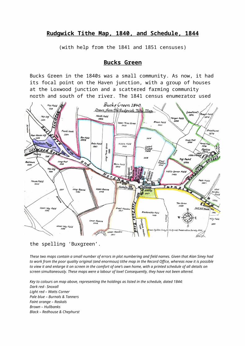
Bucks Green in the 1840s was a small community. As now, it had its focal point on the Haven junction, with a group of houses at the Loxwood junction and a scattered farming community north and south of the river. The 1841 census enumerator used the spelling ‘Buxgreen’.
These two maps contain a small number of errors in plot numbering and field names. Given that Alan Siney had to work from the poor quality original (and enormous) tithe map in the Record Office, whereas now it is possible to view it and enlarge it on screen in the comfort of one’s own home, with a printed schedule of all details on screen simultaneously. These maps were a labour of love! Consequently, they have not been altered.
Key to colours on map above, representing the holdings as listed in the schedule, dated 1844:Dark red - SnoxallLight red – Watts CornerPale blue – Burnals & TannersFaint orange – RaskalsBrown – HullbanksBlack – Redhouse & ChephurstYellow – Warhams (& Mill Hill)Green – Gaskins & HatchesSolid purple – Queen’s HeadSolid light green – SmithySolid violet – Rudgwick ParishNo colour – Tollhouse garden, and Floodgate Meadow, part of Wandford (mill) – see next map.
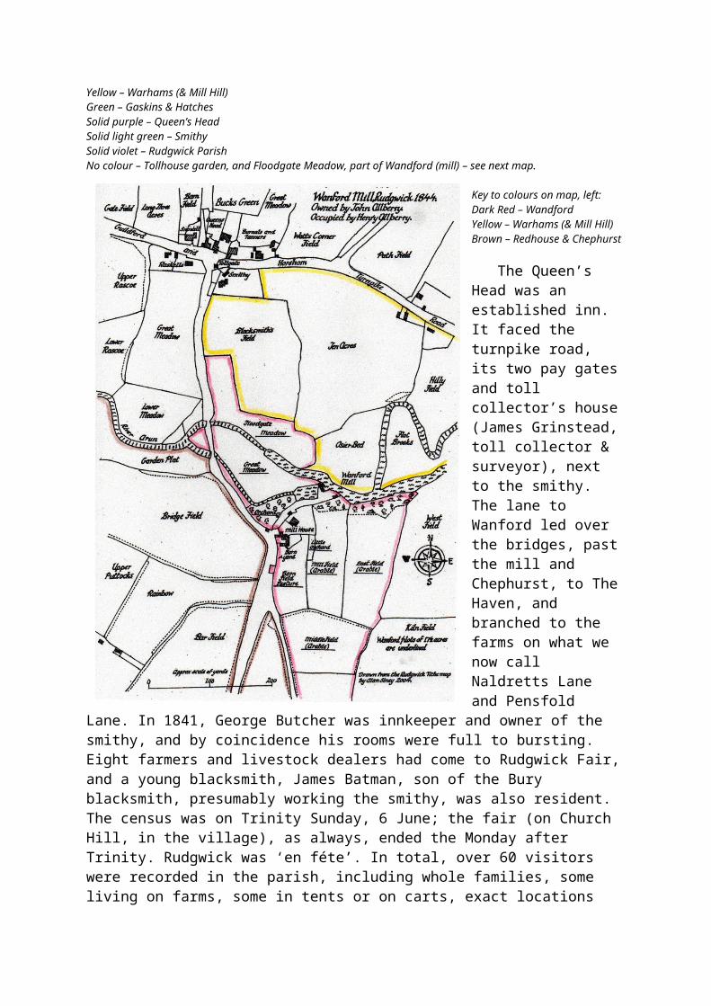
Key to colours on map, left:Dark Red – WandfordYellow – Warhams (& Mill Hill)Brown – Redhouse & Chephurst
The Queen’s Head was an established inn. It faced the turnpike road, its two pay gates and toll collector’s house (James Grinstead, toll collector & surveyor), next to the smithy. The lane to Wanford led over the bridges, past the mill and Chephurst, to The Haven, and branched to the farms on what we now call Naldretts Lane and Pensfold Lane. In 1841, George Butcher was innkeeper and owner of the smithy, and by coincidence his rooms were full to bursting. Eight farmers and livestock dealers had come to Rudgwick Fair, and a young blacksmith, James Batman, son of the Bury blacksmith, presumably working the smithy, was also resident.
The census was on Trinity Sunday, 6 June; the fair (on Church Hill, in the village), as always, ended the Monday after Trinity. Rudgwick was ‘en féte’. In total, over 60 visitors were recorded in the parish, including whole families, some living on farms, some in tents or on carts, exact locations unknown, mostly dealers but also a ‘chairbottomer’, a shoemaker, a hat maker and one cart with a publican and several waiters!
The inn was owned by Arthur French, perhaps the brewer of this name in Shere. George Butcher was soon replaced as innkeeper by George King, moving there from Exfoldwood (Tisman’s Common). A wheelwright, King made a wheel for Brewhurst Mill in 1861. His father James was also a wheelwright and farmer at Little Tittlesfold (The Haven). The King family were noted craftsmen. George Butcher moved from the pub to the smith’s cottage (Forge Cottage). His background was as a wheelwright - his father, Henry was a wheelwright, and occupied the forge and its land, in 1803). Certainly, blacksmith and wheelwright were linked trades. James Stanford (brother of the farmers mentioned below), a “wheeler” at Snoxalls probably worked for King.
The Allberry family, John and his sons, Henry and John, were millers and farmers at “Wandford”. Henry lived in the Mill House, both Johns at Burnals, in the other part of which
was Thomas Elliott, also a miller. John Allberry Snr owned Wanford, Snoxall, and Burnals and Tanners, including the premises now The Old Stores. All were small holdings. By 1851 Allberry Snr was also a grocer, so the shop may date from the 1840s or earlier. Burnals and the shop premises were built on roadside waste, if the boundaries are looked at closely. Taken together this cluster of millers and wheelwrights is remarkable, and is perhaps an early example of the linkages available from proximity enhancing all trades, not least the pub.
The map above implies that Tanners may have been a separate small holding in the distant past, as there were three fields physically separate to the west of Snoxall (but no house) – assuming Burnals is the land around the house of that name. The names of these fields: Bar Field and Gate Field, curiously, suggest there may have been a tollgate here, at the Loxwood Road junction, for a brief period between 1809 and 1840. If so, the need for another on Haven Road may be supported by a similarly named Bar Field opposite the row of houses as you go up to Collins Cross. ‘Bar’ as in ‘tollbar’ was a term for a simple gate similar to newer level crossing gates.
Furthermore, in Burnals, the names of the fields numbered 1415 and 1418, marked as ‘(later) Cricket Field’ were in fact Upper Cricket Field and Cricket Meadow respectively in 1844. This raises the intriguing possibility that cricket was played on one of these fields, perhaps 1418, before 1840. John Baker, retired solicitor-general of the Leeward Islands, from Horsham, wrote that he “went to cricket match on Broadbridge Heath between Shinfold and Rudgewick (sic).” We can assume cricket was played in Rudgwick too at this time. Indeed, the son of Rudgwick’s vicar, Reynall Cotton was playing and writing poetry at Hambledon, the famous club in Hampshire around the same time, and his father had been vicar 1716-1741, which leads me to speculate whether cricket was played here 100 years earlier than the date of the Tithe Map! It was certainly played on this field 1900 to 1930, and remains Pennthorpe’s cricket field to this day.
To the west, Daniel Cox, a bootmaker, at Raskals (called Bucks Green Place from 1851) also farmed down to the river. He owned Little Ames in Rudgwick too, where John Tate also had a shoemaking business. Boot and shoes were the last cottage industry to be mechanised, later in the century, but the largest number in Rudgwick were in The Haven. Cox was though the most successful. Raskals, or Roscoe, gave its name to the fields which today are the King George V Playing Fields.
King George’s Field was then split between Hullbanks and Redhouse, both owned by Mary Butcher of Redhouse. Including Chephurst, it was a much larger holding farmed by Edward Ireland, with his own farm, Exfold, at Tisman’s Common. Mary married Thomas Elliott (above) in 1845, thus Redhouse and Chephurst passed to the Elliotts for many years, having been in the Butcher family for many generations. Notice again the small holdings - leading to conjecture that centuries earlier these holdings were taken in from an original medieval ‘green’, but there is no corroborating evidence.
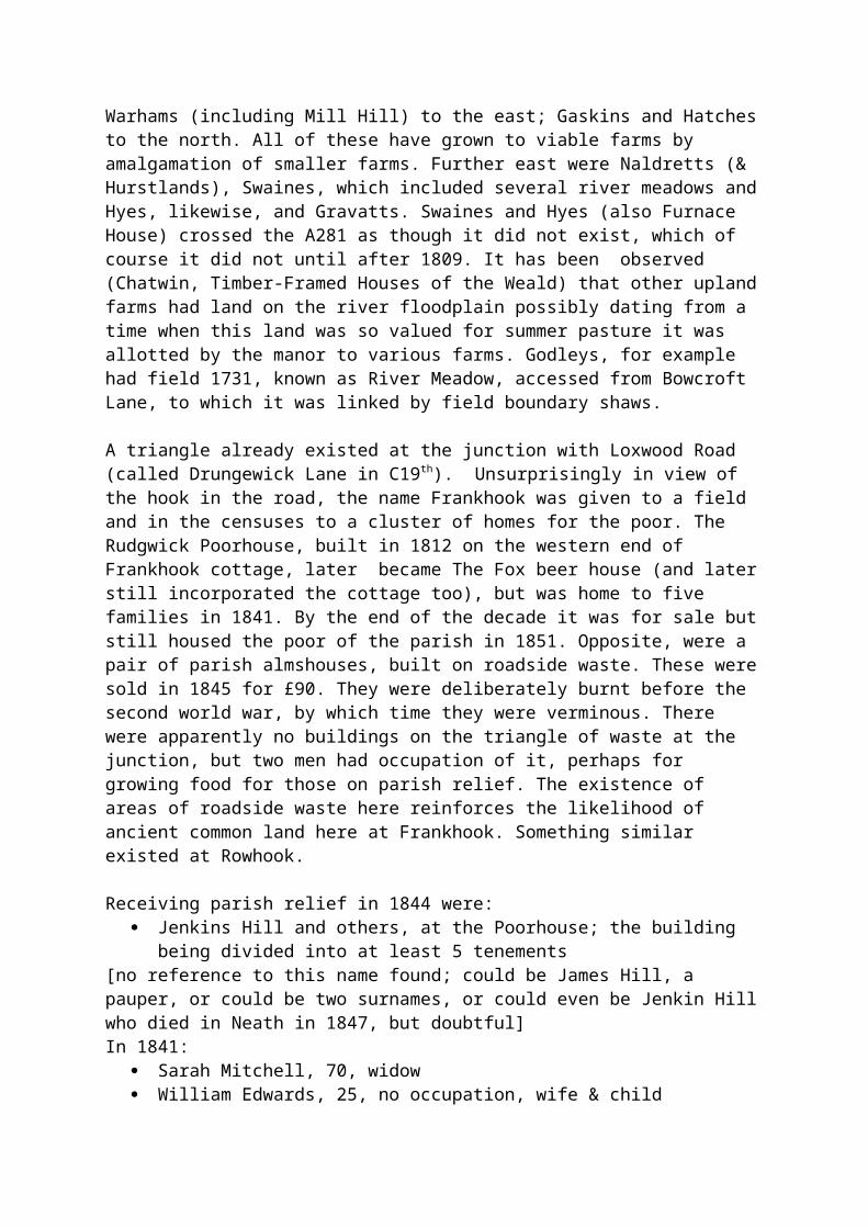
Bucks Green was also surrounded by three larger holdings: Redhouse & Chephurst (with Exfold) to the west and south; Warhams (including Mill Hill) to the east; Gaskins and Hatches to the north. All of these have grown to viable farms by amalgamation of smaller farms. Further east were Naldretts (& Hurstlands), Swaines, which included several river meadows and Hyes, likewise, and Gravatts. Swaines and Hyes (also Furnace House) crossed the A281 as though it did not exist, which of course it did not until after 1809. It has been observed (Chatwin, Timber-Framed Houses of the Weald) that other upland farms had land
on the river floodplain possibly dating from a time when this land was so valued for summer pasture it was allotted by the manor to various farms. Godleys, for example had field 1731, known as River Meadow, accessed from Bowcroft Lane, to which it was linked by field boundary shaws.
A triangle already existed at the junction with Loxwood Road (called Drungewick Lane in C19th). Unsurprisingly in view of the hook in the road, the name Frankhook was given to a field and in the censuses to a cluster of homes for the poor. The Rudgwick Poorhouse, built in 1812 on the western end of Frankhook cottage, later became The Fox beer house (and later still incorporated the cottage too), but was home to five families in 1841. By the end of the decade it was for sale but still housed the poor of the parish in 1851. Opposite, were a pair of parish almshouses, built on roadside waste. These were sold in 1845 for £90. They were deliberately burnt before the second world war, by which time they were verminous. There were apparently no buildings on the triangle of waste at the junction, but two men had occupation of it, perhaps for growing food for those on parish relief. The existence of areas of roadside waste here reinforces the likelihood of ancient common land here at Frankhook. Something similar existed at Rowhook.
Receiving parish relief in 1844 were: Jenkins Hill and others, at the Poorhouse; the building being divided into at least 5
tenements [no reference to this name found; could be James Hill, a pauper, or could be two surnames, or could even be Jenkin Hill who died in Neath in 1847, but doubtful]In 1841:
Sarah Mitchell, 70, widow William Edwards, 25, no occupation, wife & child William Longhurst, 60, ag lab, family Cornelius Garman, 31, ag lab, wife & family George Sturt, 50 ag lab, family Henry Edwards, at the Almshouses (also there in 1841, 50, ag lab, married, 7
children) John Woodhatch, at the Almshouses (also there in 1841, 20 no occupation, married, 1
child) Richard Brooker on the Poorhouse waste; in 1841 he lived at the Parish Almshouses
in The Haven, 55, ag lab, wife & family George Francis on the Poorhouse waste; in 1841 he lived at the Parish Almshouses in
The Haven, ag lab, wife & family
To north and east, farms were owned by major landowners, as elsewhere in the parish. Edward Napper, of Ifold House near Plaistow, owned Hyes (including Smithers) and Warhams (including Mill Hill), with Peter Walder living at Hyes farming all three, amounting to nearly 300 acres. Nappers had previously farmed all these named lands for several generations, and lived at Hyes from at least 1634, when it was only 20 acres. Bucks Green smithy was likewise in Napper ownership.
Edward Brice Bunny owned Naldrett House and Moorlands in Naldretts Lane and Hurstlands (The Haven), all farmed by Michael Botting who lived at Naldrett House. Bunny also owned Gaskins & Hatches (lands north of Bucks Green), including Green Lanes, and had acquired Swaines on the death of George Smith. Nothing is known about him, other than he did not reside there. The Stanford family rented in the 1840s, Henry at Hatches, John at Swaines,
their widowed mother Mary (aged 80 in 1841, allegedly still farming!) at Gaskins (now Pennthorpe School, the farmhouse was then where the car park is in front of the school). Bunny obtained the title to these farms through his own, and a previous marriage, to the Naldretts, one time gentry and owners of Naldrett House. In the 1840s he retained the underwoods in hand for his own use.
The corner of Guildford Road and Church Street has been known as Watts or Watch Corner for centuries. The field in the corner next to Burnals and Tanners was owned by James Puttock, who was a butcher and had been owner of Eames in Church Street.
Not all the tithes were assigned to the vicar. Richard Burchatt (of Dukes, Cox Green) had received (impropriated) tithe for Redhouse & Hullbanks, Swaines and Watch Corner field.
Bucks Green in the 1840s had begun to benefit from its situation astride the 1809 turnpike, a growth which would continue to the present day, albeit with traffic blight in the last few decades. Its inn, its historic mill and its smith/wheelwright businesses made it a central place in the economic activity of the parish. However, there were few inhabitants of any wealth. The Allberrys (millers and property owners) and the Bottings (yeoman tenant farmers) were probably the only families of any means.