Embed Size (px)
Citation preview
Hydrology of Humid Tropical Regions with Particular Reference to the Hydrological Effects of Agriculture and Forestry Practice (Proceedings of the Hamburg Symposium, August 1983). IAHS Publ. no. 140.
Runoff generation in tropical rainforests of northeast Queensland, Australia, and the implications for land use management
M, B0NELL Department of Geography, James Cook University of North Queensland, Townsville, Australia 4811 D. A. GILMOUR Queensland Forestry Department, Forestry Training and Conference Centre, Gympie, Australia 4570 D. S, CASSELLS Forest Research Branch, Queensland Forestry Department, Gympie, Australia 4570
ABSTRACT The aim of this paper is to review the more important findings from runoff generation studies in the tropical rainforests of northeast Queensland, Australia; and to examine a number of implications for land management and future research. Widespread overland flow is commonly recorded in the undisturbed forest. The prevailing rainfall intensities frequently exceed the saturated hydraulic conductivity of the profile below 0.2 m , which causes the rapid development of saturation in the top layer and the generation of overland flow. As a result no change in the runoff hydrology occurred following logging but suspended levels were doubled during high flows, whilst clearing produced a tenfold increase. A major problem is that the subsoil of some of the tropical soils is highly dispersible once the A horizon has been removed by logging or agriculture. Thus the frequent occurrence of overland flow and raindrop impact ensures high soil losses from sugar cane fields under monsoonal conditions.
Genèse du ruissellement dans les forêts tropicals humides de Queensland du nord-est, Australie, et les implications pour 1'aménagement des sols RESUME Le but de cet exposé est une revue générale des découvertes les plus importantes sur la genèse du ruissellement dans les forêts tropicals humides du Queensland du nord-est, Australie, et d'analyser un certain nombre d'implications pour l'aménagement des sols et pour des recherches futures. Le ruissellement extensif est généralement observe dans les forêts non perturbées. Les intensités de précipitation prévalente excèdent souvent la conductivité hydraulique saturée du profil au dessous de 0.2 m, ce qui provoque la saturation rapide dans la couche superficielle et donne lieu au ruissellement de surface. Il en résulte qu'il n'y a pas de changements dans le régime hydrologique du ruissellement à la suite de coupes forestières, mais les concentrations de matières en suspension
287
288 M.Bonell et al,
doublent pendant les ruissellements importants, tandis que la deforestation produit une augmentation dix fois plus élevée. Un problème majeur est posé par dispersion extrême du substratum de certains sols tropicaux, quand 1'horizon A a ete enlevé par les coupes forestières ou par l'agriculture. Ainsi l'apparition fréquente de ruissellement de surface, et la force d'impact des gouttes de pluie, assurent de grandes pertes de sol dans les champs de cannes à sucre pour des conditions de mousson,
irfTRODUCTION
The wet tropical coast of northeast Queensland is noted for receiving high intensity, long duration events in the summer when most of the annual rainfall occurs. However, until recently little quantitative documentation on the storm runoff hydrology has been available to resolve questions which inevitably arise concerning the ability of agricultural and forest management systems to cope satisfactorily with the annual wet season deluge.
THE RESEARCH SETTING
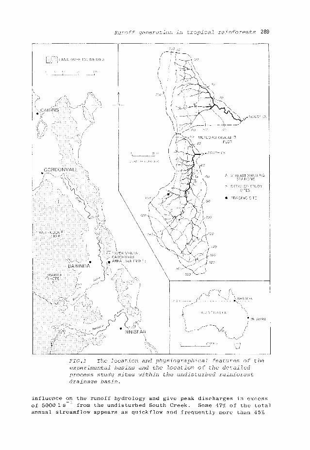
The paper centres on the paired drainage basins, viz. North Creek (18.3 ha), South Creek (25.7 ha), located 5 km east of Babinda in the wet tropical forested belt of north Queensland (Fig.l). The undisturbed vegetation is classified as mesophyll vine forest (Tracey & Webb, 1975), which is typical of the rainforest vegetation that covers much of the lower foothills.
The basins are characterized by steep slopes, e.g. South Creek average is 19 , and underlain by kaolin dominated silty clay loam to clay soils which may continue to 6 m in depth (red podzolic; Stace et al., 1968; Gn 3.11, 3.14; Northcote, 1979) formed from basic metamorphic rocks. The combination of a high root density in the top 0.2 m and the rapid incorporation of organic matter from a thin surface layer of rotting leaf and twig litter, causes a marked decline in hydraulic conductivity, K, and bulk density with depth.
The outstanding feature is the high mean annual rainfall (4239 mm, 1970-1977) with a marked concentration (63.3%) in the summer months (December-March). This is the most hydrologically active period when peak 6-min rainfall depths for individual storms range between 7 and 15 mm (70-150 mm h_1)(Bonell & Gilmour, 1980). Daily totals in excess of 250 mm are common resulting from well organized tropical lows and cyclones which develop in the monsoonal trough. The orographic effect is also important as the prevailing easterly winds are uplifted over the Bellenden Ker/Bartle Frere mountain range (1600 m a.m.s.l.), west of the drainage basins. Annual rainfall at the top of Bellenden Ker is 9140 mm (1972-1979) with the maximum 24 h total of 1140 mm recorded on 5 January 1979 as a result of tropical cyclone "Peter". Thus during the summer monsoon, rain occurring on only a few days makes up a large proportion of the annual total. In the case of the experimental basins, 23% of the 1977 annual total of 5206 mm fell in five consecutive days in February (Gilmour & Bonell, 1979a). It is these characteristics which have a significant
Runoff generation in tropical rainforests 289
FIG.l The location and physiographical features of the experimental basins and the location of the detailed process study sites within the undisturbed rainforest drainage basin.
influence on the runoff hydrology and give peak discharges in excess of 5000 1 s - 1 from the undisturbed South Creek. Some 47% of the total annual streamflow appears as quickflow and frequently more than 45%
290 M.Bonell et al.
of rainfall from individual storms appears as quickflow in the wet season.
THE MONITORING STUDIES
The initially undisturbed, paired basins were instrumented in 1969, each one with a compound V notch weir with a stilling pond and a bank of rising stage, stream water samplers. A meteorological station was established between the two drainage basins including a 0.25 mm tipping bucket raingauge and digital event recorder on a 6 min time base.
The frequency of storms enabled a short calibration period between the two streams. In June 1971, North Creek was logged and 67% of the area cleared by July 1973, then stick-raked and ploughed in preparation for the establishment of tropical pastures. This step was never undertaken because of economic problems in the beef cattle industry. Consequently the river basin remained almost completely bare for over two years before recolonization by volunteer grasses and regrowth forest.
The runoff generation studies were confined to the undisturbed South Creek. Three study sites were selected, two in the incised area of the basin and one on the upper slopes (Fig.l). At each of the plots lateral flow was collected from the surface, 0.25, 0.5 and 1.0 m depths by means of troughs 2 m long, and piped into large (3 1) tipping buckets. Each tip was translated to a digital event recorder using mercoid switches. A network of piezometers, wells and tensiometers was established upslope from the troughs at sites la and 2.
Soil water movement below 0.20 m was traced using tritiated water at site lb and an upper slope site (Fig.l). At all sites detailed investigations of soil physical properties were made, notably near-saturated hydraulic conductivity as measured by the methods of Talsma (Talsma, 1969; Talsma & Hallam, 1980). More details of the methods and experimental design are summarized elsewhere (Bonell et al., 1981, 1982, 1983a; Gilmour et al., 1980).
RESULTS
Runoff generation studies
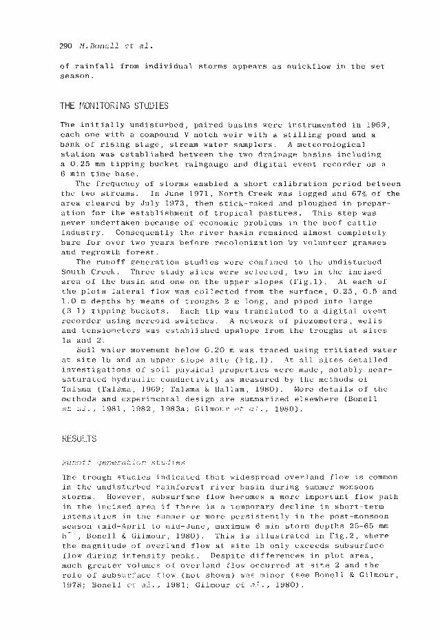
The trough studies indicated that widespread overland flow is common in the undisturbed rainforest river basin during summer monsoon storms. However, subsurface flow becomes a more important flow path in the incised area if there is a temporary decline in short-term intensities in the summer or more persistently in the post-monsoon season (mid-April to mid-June, maximum 6 min storm depths 25-65 mm h"J, Bonell & Gilmour, 1980). This is illustrated in Fig.2, where the magnitude of overland flow at site lb only exceeds subsurface flow during intensity peaks. Despite differences in plot area, much greater volumes of overland flow occurred at site 2 and the role of subsurface flow (not shown) was minor (see Bonell & Gilmour, 1978; Bonell et al., 1981; Gilmour et al., 1980).
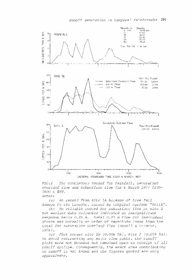
Runoff generation in tropical rainforests 291
M a x i m u m 6 mm 12 18 24 30 60
Tota l Rainfal l
D e p t h s 6 58 m
11 59 14 92 16 34 2018 39 68
71 36 m m
Total Plot Runoff Saturation Overland Flow 297 53 Litres 025 m Flow 400 80 Litres 0 50 m Flow 22 26 Litres
Saturation Overland Flow Total Plot Runoff
109100 Litres
1300 1400 1500 1600 EASTERN STANDARD TIME (EST) 6 MARCH 1977
FIG.2 The continuous record for rainfall, saturation overland flow and subsurface flow for 6 March 1977 1230-1600 h EST. Notes:
(a) No record from site la because of tree fall damage to the troughs, caused by tropical cyclone "Keith".
(b) No reliable record for subsurface flow at site 2 but earlier data collected indicated an insignificant response below 0.25 m. Total 0.25 m flow for individual storms was normally an order of magnitude lower than the total for saturation overland flow (Bonell S Gilmour, 1978).
(c) Plot areas: site lb (0.006 ha), site 2 (0.016 ha). To avoid redirecting any major flow paths, the runoff plots were not bounded but remained open to receipt of all runoff upslope. Consequently, the exact area contributing to runoff is not known and the figures quoted are only approximate.

292 M.Bonell et al.
The relationship between rainfall intensity and soil hydraulic properties explains these patterns. The surface soils (0-0.1 m) are highly transmissive (log mean K = 20.13 m day ", > 800 mm h ") to even peak monsoonal intensities. However, it is in the subsoil below 0.2 m that the prevailing rainfall intensities rapidly exceed the K values. In addition the available capacity for water in the top 0.15-0.20 m layer (soil matrix AWSC, 41-52 mm, 0-15 bars at site lb; AWSC, 19-25 mm, 0-15 bars, at upper tracing site) , is frequently exceeded during prolonged rainfall events because the matrix potential is persistently close to saturation (Bonell et al., 1983a). This causes the rapid development of positive matric potentials and saturation in the top layer which leads to "saturation overland flow" (Kirkby & Chorley, 1967) and rapid subsurface flow. The saturation overland flow is considered to be a mixture of "surface storm flow" and "subsurface storm flow", as defined by Hewlett (1974). The magnitude of the lateral and vertical storm flow components is determined by the spatial variability of the subsoil K. The log mean K of the 0.20-1.0 m layer at site 2 (K, 0.02 m day-", < 1 mm h is an order of magnitude lower than at sites la and lb (K, 0.11-0.16 m day , 5-7 mm h ). This results in only a smaller proportion of rainfall input being transmitted vertically below 0.2 m and more water available for surface and subsurface flow at site 2. In the incised area any decline in rainfall intensities below monsoonal levels means that vertical recharge can accommodate more of the input and subsurface flow becomes a more important process. This component depletes the upper water store making less input available for overland flow.
Cross-correlation analysis indicated that this is a remarkably sensitive environment with maximum coefficients corresponding with response times of 6-12 min saturation overland flow, 12 min for 0.25 m flow and 24 min for stream discharge despite differing storm lengths and intensities. This is a function of several factors including high rainfall intensities, sparsely littered forest floor, large volume of biopores in the topsoil, high antecedent soil moisture, steep slopes and a high drainage density during storms.
More complete descriptions of these studies including a statistical model of the runoff generation process are given elsewhere (Bonell & Gilmour, 1978; Bonell et al., 1979, 1981; Gilmour & Bonell, 1979b; Gilmour et al., 1980).
Tracing studies
The tracing experiments established that both the vertical and down-slope flux of soil water below 0.2 m occurred through interstitial piston flow (Horton & Hawkins, 1965; Zimmermann et al., 1967) acting in conjunction with preferential flow in the macropores (Beven & Germann, 1982). The general advance of the interstitial piston flow was slow and the experiments indicated that there was a long soil water transit time, particularly below 1 m, despite the high levels of hydrological activity in the upper profile. Another factor delaying the vertical advance of the tritium pulse was upward movement of soil water in various sections of the profiles suggested from the distribution of hydraulic potential under different hydrological conditions. More details of this work are to be found

Runoff generation in tropical rainforests 293
elsewhere (Bonell et al., 1982, 1983a).
The effects of logging and clearing on the storm runoff hydrology and water quality
The following summary concerns data analysis up to the end of 1975. More complete details of this work have already been reported (see Gilmour, 1977a).
After logging and clearing in North Creek , there was no detectable change in quickflow volume, quickflow duration or time to peak and only weak statistical evidence for a small increase in peak discharge. These characteristics imply that there are only minor changes in the storm runoff pattern in the wet season.
However, major changes were evident in the water quality of North Creek after the change in land use. Peak suspended sediment concentrations rose from about 180 ppm before logging to about 320 ppm during the first year after logging and about 520 ppm during the second year after logging. The most dramatic change came on clearing which produced more than a tenfold increase in suspended sediment levels to between 2000-4000 ppm during high flows. These high levels persisted until 1976 and though much reduced, had still not returned to pre-clearing levels by 1981. Bed load was not directly measured but 3-4 m of material has had to be removed from the North Creek stilling well after each wet season. Before clearing, the same period showed no noticeable accumulation of bed load material.
DISCUSSION
The combination of high prevailing rainfall intensities and the experimental basins soil hydraulic properties, places this environment in part of the extreme "wet" hydrological situation. The frequency of rainfall events maintains a low matric potential in the basin soils, thus allowing saturation and runoff to redevelop almost instantaneously with the onset of intense storms between December and mid-June. This means that the amount of vegetation which remains on the basin slopes, and the condition of the top 0.2 m of soil are relatively unimportant factors in terms of quickflow generation. However, the study shows that the same two factors are of great importance in controlling surface wash and erosion. The extensive network of buttressed and surface roots of the rainforest provides some impediment to downslope sediment transport that otherwise occurs given the presence of widespread overland flow. In addition, the surface soil has been ameliorated by the continual incorporation of organic matter to provide a thin but very stable and highly permeable zone. On removal of the rainforest such protection is lost and the B horizons of certain granite and metamorphic soils are highly dispersive on exposure (unpublished data, Middleton, 1930). The least dispersive soils of the area are those derived from basalt and colluvium, and the soils in the experimental basin,
294 M.Bone 11 et al.
IMPLICATIONS FOR LAND MANAGEMENT
The main objective is to control water quality. In terms of forest harvesting, it is essential to retain undisturbed streamside buffer strips up to 20 m wide. These have two functions. The first is to prevent harvesting operations creating soil disturbances in the stream bed or along the immediate stream banks. The second is to trap some of the sediment transported by overland flow towards the stream. However, the nature of the runoff process means that inevitably some of the suspended load will pass through and enter the creek.
Regular road and snig track drainage into the adjacent undisturbed forest is also necessary to reduce water velocities over the exposed soil. Failure to do this exposes the highly dispersive subsoil at many sites leading to spectacular gully erosion up to 12 m deep (Gilmour,1977b).
Where rainforests are cleared for conversion to alternative land uses, the presence of widespread surface runoff means that there is a high erosion potential. In fully vegetated fields under well managed pasture, the soil is effectively shielded from raindrop impact and there are many impediments to surface wash. In these situations there is little evidence of significant soil erosion even after intense monsoonal storms. However, erosion in mature sugar cane remains a problem because the cultivation is aligned in sympathy with the slope instead of a contour layout to facilitate mechanical harvesting. This can result in wholescale movement of the topsoil to the slope base on even moderate slopes during heavy monsoonal events. The situation can be disastrous in young sugar cane and late cultivated ratoon crops. After 2260 mm of rain in the period 1-14 January 1981, in Innisfail, estimated erosion losses ranged from 10 t ha on areas protected by plant residues to over 500 t ha on bare fields cultivated with slopes up to 20% on basalt. Spectacular gully erosion occurred up to 3 m deep and 10 m wide (Capelin, personal communication 1981).
The long soil water transit time documented during the soil moisture tracing studies indicates that despite the intense surface hydrological activity, there is some potential for agricultural chemical inputs to accumulate in the deeper horizons in intensive agricultural systems such as sugar cane. Long term environmental monitoring of soil water quality would seem essential for sustained commodity production in this region.
CONCLUSIONS
The prevailing high rainfall intensities and the soil hydraulic properties ensure that widespread overland flow is common and that a high proportion of inputs are quickly routed out of undisturbed tropical rainforest as quickflow in the experimental basins. This results in serious erosion losses in disturbed areas unless correct management procedures are followed. In this context these experimental basins occupy part of the "wet" spectrum in comparison with other tropical rainforest areas based on the relationship between synoptic climatology and rainfall intensity (Gilmour et al., 1980).

Runoff generation in tropical rainforests 295
However, within northeast Queensland, the rainfall characteristics of these basins are by no means the most extreme when compared with the hydrometeorological conditions experienced on the mountains further west. Many of the management problems discussed in this paper will only be accentuated in such areas.
However, knowledge of the hydrology of the area is far from complete and many more problems still need to be investigated. A more complete picture of the spatial variability of soil hydraulic properties throughout the experimental basins is desirable. Also the implicit assumption in the discussion of this paper is that similar hydrological processes operate elsewhere in north Queensland. Investigations of regional patterns of soil hydraulic properties have been initiated (Bonell et al., 1983b), but regional rainfall intensity patterns are still required before the Babinda basin model can be clarified in terms of describing the region's hydrology. In addition, a detailed understanding of erosion processes both in the undisturbed setting and the managed setting is required.
ACKNOWLEDGEMENTS This work has been supported by the Australian Water Resources Council, Queensland Forestry Department, James Cook University of North Queensland, and the Queensland Water Resources Commission. The paper was initially drafted by M.Bonell whilst he was undertaking a Special Studies Programme in the Laboratory of Physical Geography and Soil Science, University of Amsterdam. The authors would like to thank the Laboratory for the facilities it made available for the preparation of the paper.
Marie Keijzer-v.d.Lubbe typed the original manuscript and prepared the French translation, and Monique de Vré (University of Amsterdam) and Trevor Shearn (James Cook University of North Queensland) arranged the diagrams.
REFERENCES
Beven, K. & Germann, P. (1982) Macropores and water flow in soils. Wat. Resour. Res. 18, 1311-1325.
Bonell, M. & Gilmour, D.A. (1978) The development of overland flow in a tropical rainforest catchment. J. Hydrol. 39, 365-382.
Bonell, M. & Gilmour, D.A. (1980) Variations in short-term rainfall intensity in relation to synoptic climatological aspects of the humid tropical northeast Queensland coast. Singapore J. Tropical Geogr. 1 (2), 16-30.
Bonell, M., Gilmour, D.A. & Sinclair, D.F. (1979) A statistical method for modelling the fate of rainfall in a tropical rainforest catchment. J. Hydrol. 42, 241-257.
Bonell, M., Gilmour, D.A. & Sinclair, D.F. (1981) Soil hydraulic properties and their effect on surface and subsurface water transfer in a tropical rainforest catchment. Hydrol. Sci. Bull. 26, 1-18.
Bonell, M., Cassells, D.S. & Gilmour, D.A. (1982) Vertical and lateral soil water movement in a tropical rainforest catchment. In: National Symposium on Forest Hydrology (Proc. Melbourne Symp. , May 1982) (ed. by E.M.O'Loughlin & L.Bren) 30-38.Institution of

296 M.Bonell et al,
Engineers, Australia/Forest Hydrology Working Group Australian Forestry Council, Canberra.
Bonell, M., Cassells, D.S. & Gilmour, D,A. (1983a) Vertical soil water movement in a tropical rainforest catchment in northeast Queensland. Earth Surf. Processes 8 (3).
Bonell, M., Gilmour, D.A, & Cassells, D.S. (1983b) A preliminary survey of the hydraulic properties of rainforest soils in tropical northeast Queensland and their implications for the runoff process. In; Rainfall Simulation, Runoff and Soil Erosion, Catena Supplement no. 4 (ed. by J,de Ploey) (in press).
Gilmour, D.A. (1977a) Effects of logging and clearing on water yield and quality in a high rainfall zone of northeast Queensland. In: The Hydrology of Northern Australia (Proc. Brisbane Hydrol . Symp . June 1977), 156-160. Institution of Engineers Australia, Nat. Conf . Publ. 77/5, Canberra.
Gilmour, D.A. (1977b) Logging and the environment, with particular reference to soil and stream protection in tropical rainforest situations. In: Guidelines for Watershed Management, 223-235. FAO Conservation Guide no. 1, FAO, Rome.
Gilmour, D.A. & Bonell, M. (1979a) Six-minute rainfall intensity data for an exceptionally heavy tropical rainstorm. Weather 34, 148-158.
Gilmour, D.A. & Bonell, M. (1979b) Runoff processes in tropical rainforests with special reference to a study in northeast Australia. In: Geographical Approaches to Fluvial Processes (ed. by A.F.Pitty), 73-92. GeoBooks, Norwich, UK.
Gilmour, D.A., Bonell, M. & Sinclair, D.F. (1980) An investigation of storm drainage processes in a tropical rainforest catchment. Australian Water Processes Council, Technical Paper 56. Australian Government Publishing Service, Canberra.
Hewlett, J.D. (1974) Comments on letters to "Role of subsurface flow in generating surface runoff, 2 upstream source areas" by R.Allan Freeze. Wat. Resour. Res. 10, 605-607.
Horton, J.H. & Hawkins, R.H. (1965) Flow path of rain from the soil surface to the water table. Soil Sci. 100, 377-383.
Kirkby, M.J. & Chorley, R.J. (1967) Throughflow, overland flow and erosion. Bull. I ASH 12, 5-21.
Middleton, H.E. (1930) Properties of soils which influence soil erosion. USDA Tech. Bull. 178, 1-16.
Northcote, K.H. (1979) A Factual Key for the Recognition of Australian Soils, 4th edn. Rellim Technical Publications, Glenside, South Australia.
Stace, H.C.T., Hubble, G.D., Brewer, R., Northcote K.H., Sleeman, J.R., Mulcahy, M.J. & Hallsworth, E.G. (1968) A Handbook of Australian Soils. Rellim Technical Publications, Glenside, South Australia.
Talsma, T. (1969) In situ measurement of sorptivity. Austral. Soil Res. 7, 269-276.
Talsma, T. & Hallam, P.M. (1980) Hydraulic conductivity measurement of forest catchments. Austral. J. Soil Res. 18, 139-148.
Tracey, J.G. & Webb, L.J. (1975) A key to the vegetation of the humid tropical region of north Queensland - Bartle Frere 1:100 OOO sheet. CSIR0 Rainforest Ecology Unit, Div. Plant Industry, Long Pocket Laboratories, Indooroopilly, Brisbane, Queensland.

Runoff generation in tropical rainforests 297
Zimmermann, U. , Munnich, K.O. & Roether, W. (1967) Downward movement of soil moisture traced by means of hydrogen isotopes. In: Isotope Techniques in the Hydrological Cycle (ed. by G.E.Stout), 28-36. Geophysical Monograph Series, 11, American Geophysical Union, Washington, DC.