Embed Size (px)
Citation preview
Angela M Walker, Environmental Consultant Tel: 01252 879237 2 Chelwood Drive E-mail: [email protected] Sandhurst, Berkshire GU47 8HT
RUSPER ROAD, IFIELD
An Extended Phase 1 Habitat Survey carried out for Jacobs Engineering U.K. Ltd
Angela M. Walker
2009
CONTENTS OF REPORT CONTENTS OF REPORT ............................................................................................2 MAP 1 – LOCATION OF RUSPER ROAD SITE .......................................................3 RUSPER ROAD, IFIELD – EXTENDED PHASE 1 HABITAT SURVEY................4
Introduction and Background ....................................................................................4 Methodology ..............................................................................................................4
SURVEY SUMMARY..................................................................................................5 Woodland...................................................................................................................5 Parkland and Scattered Trees.....................................................................................6 Scrub ..........................................................................................................................6 Grassland....................................................................................................................6 Marshy Grassland ......................................................................................................7 Running Water ...........................................................................................................7 Hedgerows .................................................................................................................8 Protected Species .......................................................................................................9
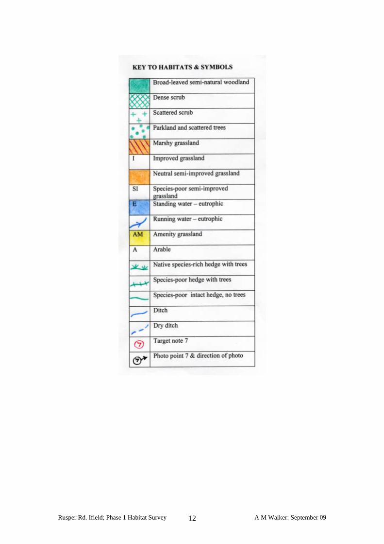
MAP 2 – HABITATS ..................................................................................................11 TABLE 1 – TARGET NOTES ....................................................................................13 TABLE 2 - PLANT SPECIES RECORDED ..............................................................18 PHOTOGRAPHS ........................................................................................................21
Rusper Rd. Ifield; Phase 1 Habitat Survey A M Walker: September 09 2
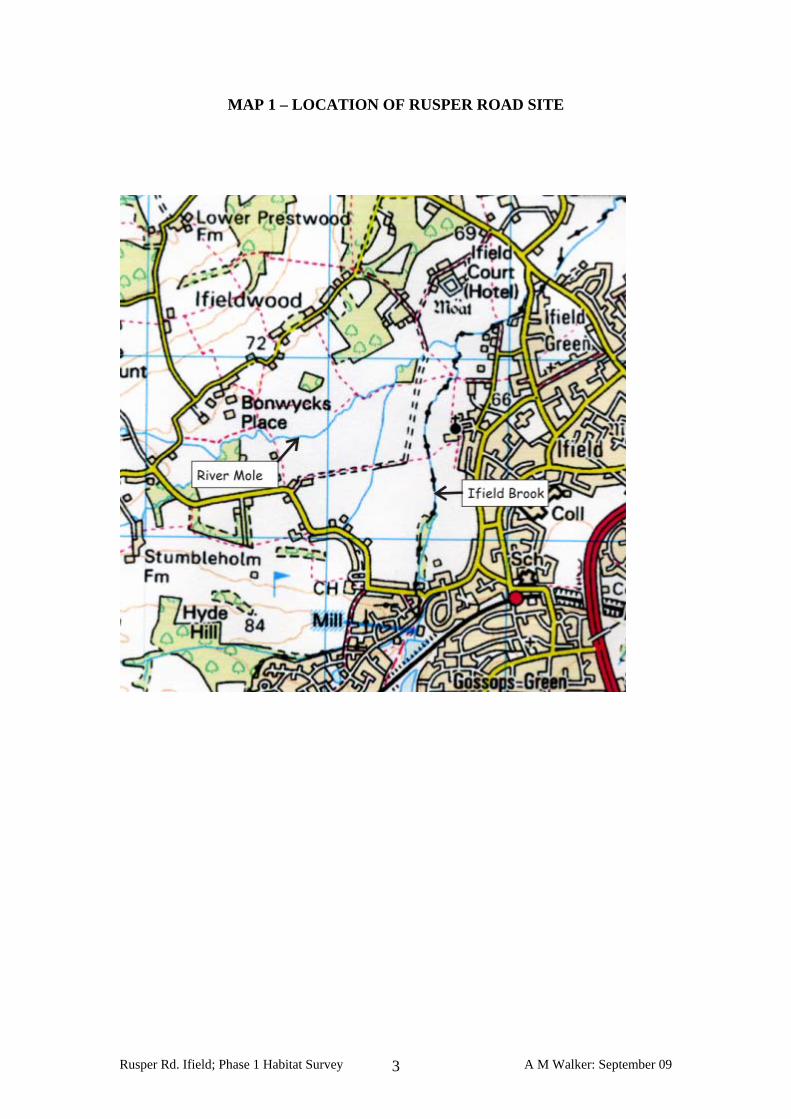
MAP 1 – LOCATION OF RUSPER ROAD SITE
Rusper Rd. Ifield; Phase 1 Habitat Survey A M Walker: September 09 3
RUSPER ROAD, IFIELD – EXTENDED PHASE 1 HABITAT SURVEY
Introduction and Background The study covers land on the western side of Ifield, on the edge of Crawley. The site is bounded by Rusper Road to the south, Ifield Wood to the west/northwest and Ifield Court to the north-east. It lies within the Low Weald Natural Character Area as described by English Nature. This is a broad, low-lying clay vale that runs through Kent, Sussex and Surrey. It is characterised by a patchwork of fields, small woods and hedgerows with settlements typically located on pockets of limestone and sandstone. Within the study area there are no designated statutory sites of nature conservation value, such as an SSSI or LNR, although one grass field is a local site of interest as a species rich meadow with archaeological features. Along the northern boundary of the site there is an area that has been identified as a Biodiversity Action Plan (BAP) priority habitat, wet woodland. A small part of this lies within the survey area. A habitat survey has been carried out to assess the possible impact of the construction a dam as part of a flood alleviation scheme. The dam would create a flood storage area on land beside two watercourses, the Ifield Brook and the upper reaches of the River Mole together with linked low-lying areas. This survey aims to provide background information on any habitats that could be affected by the periodic flooding which would result. It also includes three temporary construction routes and a site compound. Methodology Surveys were undertaken on using the standard methodology for Phase 1 Habitat Survey, as described in the JNCC handbook1. The vegetation types were mapped using standard codes and the dominant and/or representative species for each habitat were recorded. A colour coded map has been produced together with a series of target notes giving a brief description of areas of the site and features of interest. As this methodology is primarily concerned with vegetation the survey was extended to include any observations and field signs of fauna, particularly protected groups and species such as bats, badger, water vole and otter. Although an exhaustive search for presence of these animals was beyond the scope of the survey the habitat potential for these species was noted. The survey was carried out between 24th and 30th July 2009. A general summary of the results of the survey is presented below.
1 Joint Nature Conservation Committee (1993) Handbook for Phase 1 Habitat Survey. JNCC, Peterborough
Rusper Rd. Ifield; Phase 1 Habitat Survey A M Walker: September 09 4
SURVEY SUMMARY The following habitats were identified in the study area and are shown on the attached colour-coded map.
♦ Woodland ♦ Parkland and scattered trees ♦ Scrub – dense and scattered ♦ Grassland ♦ Marshy grassland ♦ Running water ♦ Hedgerows
In addition there are minor areas of Tall ruderal, Standing water and Marginal vegetation. These are described in the target notes. Each of the main habitat types is described briefly below. Woodland The dominant woodland type is broadleaved semi-natural. An area of ancient woodland lies to the north of the site near Ifieldwood, but only a tiny corner is within the contour boundary. This is linked to a small block of broad-leaved woodland with a similar structure (target note 12) consisting of pedunculate oak, ash and field maple with an understorey of common hawthorn, blackthorn, bramble and saplings of canopy species. The field/ground layer includes a range of typical woodland plants such as wood avens, false brome, dog’s mercury and ground ivy as well as ivy and numerous tree seedlings. There are several old oak trees with dead wood and cavities. A block of damp, more even-aged woodland lies on the south bank of the River Mole (target note 17). This includes a few European larch as well as hornbeam, downy birch, grey willow, field maple and self-sown ash, some of the latter drawn and closely spaced. The field layer is sparse in places but overall includes a variety of typical woodland species. Apart from small corners the majority of the remaining woodland lies along the Ifield Mill Stream. The area west of the district boundary (target note 39) is younger with a mixed structure including an area self-sown and spindly alder over uneven, rutted ground and an area of mixed scrub. To the east of the boundary line and enclosing the stream the woodland has a varied woody flora and structure with a diverse age range and good regeneration. There is also a varied flora in the field layer including bluebell, false brome, enchanter’s nightshade, wood sedge, ground ivy, wood avens, red campion, honeysuckle and male fern. The woodland includes a good quantity of standing and fallen dead wood and there are a number of old and veteran trees. The dead wood is a significant habitat for fungi and invertebrates and the tree cavities provide nest sites for a range of bird species. A number of the trees could support bat roosts.
Rusper Rd. Ifield; Phase 1 Habitat Survey A M Walker: September 09 5
Parkland and Scattered Trees The line of fields to the east of Ifield Brook and Ifield Mill Stream are a mosaic of rough grass and clumps of scrub and trees. A network of mown footpaths crosses the fields and is in regular use by local people. There are numerous young and medium age trees scattered through the fields, particularly in the southern fields (target notes 35, 36). Many are pedunculate oak and ash and a few of these trees have been planted although others are self-sown. There are also scattered bushes of common hawthorn, hazel, field rose, grey willow and blackthorn. Clumps of dense bramble and blackthorn occur in places, again particularly in the southern fields, and patches of mixed scrub and saplings are also present. The grassland is dominated by largely improved grassland, possibly re-seeded in origin in some fields or parts of fields. The flora consists largely of common grasses and herbs including Yorkshire fog, cock’s-foot, false oat-grass, Timothy, creeping bent, rough meadow-grass with occasional patches of common knapweed, bush vetch and bird’s-foot trefoil. There are areas with a shorter sward of red fescue in several of the fields, particularly the northern ones (target notes 28, 31). These are typically grazed by rabbits and several have numerous anthills of meadow ant including large and well established ones as illustrated in photographs 16 and 18. The fields are enclosed by strips of woodland and scrub formed by overgrown hedgerows and providing additional shelter. These are described in a separate section below. The complex mosaic of vegetation types across the fields creates a diverse structure and pattern of habitats which is potentially rich in invertebrates, small mammals and birds. Scrub The parkland includes patches of both scattered and dense scrub as described above. There is another strip of dense scrub to the north of the footpath from Ifield Green (target note 25). This consists mainly of blackthorn and bramble but it links with strips of more varied cover along the overgrown hedgerows to the north and south. Grassland Other areas of grassland are present to the east near to Ifield where there are relatively few trees or shrubs and more open grassland habitat. Most of these are relatively species-poor but two of the fields have a high cover of herbs (target notes 29, 30) with extensive common knapweed, meadow vetchling, bird’s-foot trefoil and ribwort plantain, attracting a variety of bees, hoverflies and other insects. To the north-east of the survey area there is another field, probably a hay meadow, with abundant common knapweed as well as agrimony (target note22). The species-rich meadow of known value lies between the two watercourses (target note 21) near to the confluence of the streams. The vegetation has been mown across part of the field and left uncut to the north of the footpath. This semi-improved grassland has a high cover of herbs including abundant white and red clovers,
Rusper Rd. Ifield; Phase 1 Habitat Survey A M Walker: September 09 6
common sorrel, ribwort plantain and cat’s-ear and a variety of other herbs such as burnet-saxifrage and meadow vetchling. The sward in the meanders alongside the Ifield Brook is damp and supports other species such as crosswort and meadowsweet. It appears that encroaching blackthorn has recently been cleared along this margin. Other semi-improved fields, probably hay meadows, were found beside the River Mole (target notes 7 and 13). These fields are separated by a discontinuous line of pedunculate oak trees and blackthorn. The flora is similar in both with a variety of common grasses including meadow barley, crested dog’-tail, meadow foxtail, Timothy and Yorkshire fog. There is a greater herb cover to the western field where there is abundant common knapweed, bird’s-foot trefoil, common sorrel, smooth tare, meadow buttercup and other species. A long narrow strip of grassland runs through the centre of the area between the two watercourses, bounded by wide, overgrown hedgerows (target note 20). The flora is species-poor over most of the strip although there are patches of remnant interest with a more varied mix of grasses and a few common herb species including yarrow and cat’s-ear. Marshy Grassland The area of marshy grassland is small and not species-rich although it provides a refuge for certain species not found elsewhere on the site. It lies on the edge of the marked study area to the north of the River Mole and is located in the southern corner of a field adjacent to a small pond (see target note 9). The field and pond banks are heavily grazed by ponies and Canada geese but near the pond there are large patches of grazed common fleabane together with jointed and hard rushes and self-heal. The southern corner of the paddock is taller and less disturbed and here there is a mixed flora of marsh and fen species including reed sweet-grass, meadowsweet, hemlock water-dropwort, yellow iris and the less common species sneezewort. A narrow strip of marshy grassland runs beside the footpath to the east of this field, with abundant common fleabane and hemlock water-dropwort along the hedge-line. Running Water The survey area is dominated by the two watercourses, the River Mole and its tributary, the Ifield Brook. The upstream end of the latter is marked Ifield Mill Stream on the Ordnance Survey map but it no longer has any characteristics of a mill stream. A small side stream runs to the east of the Ifield Mill Stream but the channel shown to the west, following the line of the district boundary, is not evident on site apart from a shallow dip at the northern end. The River Mole and the Ifield Brook are similar in character although the River Mole is slightly larger. Both have high, steep banks that may be indicative of past overdeepening although the banks have long been untouched over most of the site. The watercourses are largely shaded by mature trees and shrubs and the clay banks have re-naturalised to form extensive cliffs and varied profiles. The channel form is equally diverse with numerous bars, pools, riffles and varied width and depth, particularly along the River Mole. The underlying substrate is clay, overlain with gravel and limited accumulations of silt over most of the site.
Rusper Rd. Ifield; Phase 1 Habitat Survey A M Walker: September 09 7
There is a short length of silty channel along the River Mole where the banks are open and dominated by tall herbs. Here the channel flora is a mixture of tall branched bur-reed and reed sweet-grass. Some silt bars have formed in the reach alongside the woodland (see photos 10, 11). Elsewhere there is little channel vegetation on either watercourse due to the extent of the shade. A few clumps of yellow iris, pendulous and remote sedges were noted. The small side channel off the Ifield Mill Stream has small clumps of these species plus fool’s water-cress. The trees and shrubs along the banks are a feature of both watercourses with numerous old and mature trees present, dense cover and varied species composition. There are numerous trees with dead wood, cavities and exposed root systems that could provide roosts for bats as well as potential for a diverse invertebrate and bird faunas and lower plant flora. Several other field boundaries are marked by ditches, all heavily shaded and most dry or damp with no standing or running water. The only exception is the ditch to the west of the central strip of grassland. This ditch (target note 19) had shallow standing water on the day of the survey with small beds of brooklime and fool’s water-cress. The steep banks are largely shaded and support occasional ferns and meadow-sweet. One other ditch (target note 25) has small clumps of hemlock water-dropwort where there are gaps in the cover. Hedgerows The hedgerows and strips of trees around the site are a key feature for wildlife. There are several boundary banks, such as between the playing field and the grass field to the west (target note 37). The strip of cover along this boundary is wide and has a varied structure of vegetation similar to a woodland edge. The species composition is varied and includes a range of ages from young trees to overmature specimens. The field layer beneath the canopy includes a variety of woodland species including bluebell, enchanter’s nightshade and wood sedge. This strip extends along the eastern edge of the survey area from the south to level with the footbridge across the brook, and it links with several other overgrown hedgerows that run eastwards towards Rusper Road. The small, dry ditches that cross the fields south of Rectory Farm are lined with narrower but similar overgrown hedgerows, also with a number of mature and overmature pedunculate oak and ash trees. These provide links between the various boundaries, the woodland and the cover along the watercourses. Further north near to Ifield Green there are a few hedgerows with occasional non-native species such as false acacia and copper beech. Along the River Mole there are other mature hedgerows of which the most important links the area of ancient woodland to the cover on the river (target note 15). This has a sparse field layer flora with woodland and shade tolerant species including soft shield and hart’s-tongue ferns, bluebell and greater stitchwort. There is another species-rich hedgerow (target note 6) linking the river to a small block of woodland outside the survey area. The remaining hedgerows are either gappy, clipped low or do not form a good link with other woody habitats.
Rusper Rd. Ifield; Phase 1 Habitat Survey A M Walker: September 09 8
Protected Species The legislation regarding protected species is covered in the 2006 report by Entec UK Ltd. for the Tilgate Lake survey. The following observations were made regarding the potential for protected species in the current survey. Bats The site is notable for its mature and veteran trees and there are a significant number of trees that could support bat roosts. These range from those with small crevices and areas of loose bark to larger holes arising from loss of limbs or woodpecker activity. The mosaic of habitats and structure of vegetation to the east of Ifield Brook also provides good feeding for certain species of bats. A detailed bat survey by licensed surveyors is required to follow up this report. Hazel Dormouse The areas of woodland with extensive linked mature hedgerows and strips of woody cover could provide a habitat for hazel dormouse, although there is a relatively low frequency of hazel bushes across the area. Other suitable foods such as hawthorn, bramble, ash and oak are, however, plentiful. A detailed survey is required to follow up this report. Badger No signs of the presence of badgers were noted. Water vole No signs were found of water vole activity and the heavily shaded watercourses would appear unsuitable. Otter No signs were found and the area is probably too heavily used, although some of the trees along the River Mole have potential as otter holts. Amphibia No signs were found of Great crested or other newt species although a detailed survey could not be conducted. The small village pond is the most likely site but this lies just outside the target area. The other small pond north of the River Mole is probably too heavily grazed as well as being used by geese and ducks. Reptilia No signs were found although the habitat is suitable particularly for grass snake. The mixed short and long grass fields and mixed habitats to the east of Ifield Mill Stream/Ifield Brook may also have potential for common lizard, slow worm and adder. The abundance of fallen wood provides potential winter refugia for both reptiles and amphibians. Additional surveys by licensed surveyors are required to determine whether any protected species are present.
Rusper Rd. Ifield; Phase 1 Habitat Survey A M Walker: September 09 9

Invertebrates The dead wood habitat associated with the woodland may support other invertebrates of note such as beetles, as mentioned above. The diverse structure and composition of the habitats to the east of Ifield Brook/Ifield Mill Stream offer potential for a wide range of moths, grasshoppers, butterflies, spiders and other invertebrates. Birds Kingfishers were seen along the River Mole and adjacent field boundaries. There are numerous cliffs with potential for nest burrows. Skylarks were singing over the arable fields south of the River Mole and east of Pound Cottages.
Rusper Rd. Ifield; Phase 1 Habitat Survey A M Walker: September 09 10
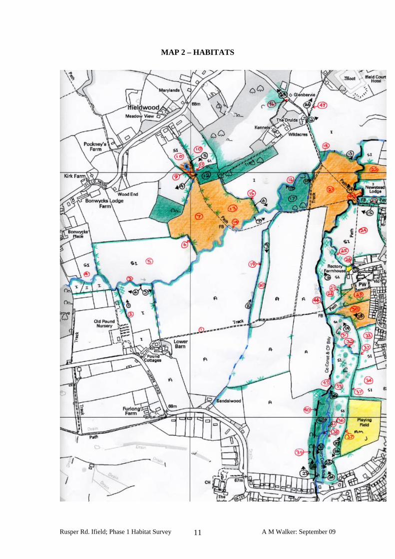
MAP 2 – HABITATS
Rusper Rd. Ifield; Phase 1 Habitat Survey A M Walker: September 09 11
Rusper Rd. Ifield; Phase 1 Habitat Survey A M Walker: September 09 12
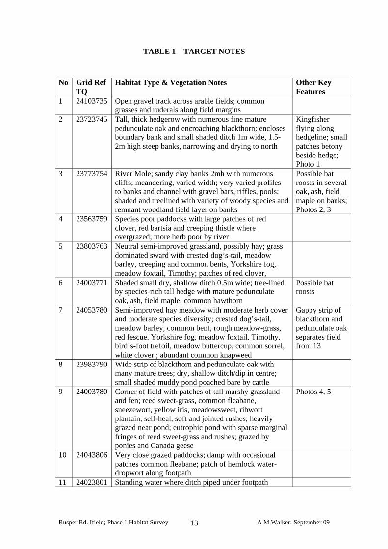
TABLE 1 – TARGET NOTES No Grid Ref
TQ Habitat Type & Vegetation Notes Other Key
Features 1 24103735 Open gravel track across arable fields; common
grasses and ruderals along field margins
2 23723745 Tall, thick hedgerow with numerous fine mature pedunculate oak and encroaching blackthorn; encloses boundary bank and small shaded ditch 1m wide, 1.5-2m high steep banks, narrowing and drying to north
Kingfisher flying along hedgeline; small patches betony beside hedge; Photo 1
3 23773754 River Mole; sandy clay banks 2mh with numerous cliffs; meandering, varied width; very varied profiles to banks and channel with gravel bars, riffles, pools; shaded and treelined with variety of woody species and remnant woodland field layer on banks
Possible bat roosts in several oak, ash, field maple on banks; Photos 2, 3
4 23563759 Species poor paddocks with large patches of red clover, red bartsia and creeping thistle where overgrazed; more herb poor by river
5 23803763 Neutral semi-improved grassland, possibly hay; grass dominated sward with crested dog’s-tail, meadow barley, creeping and common bents, Yorkshire fog, meadow foxtail, Timothy; patches of red clover,
6 24003771 Shaded small dry, shallow ditch 0.5m wide; tree-lined by species-rich tall hedge with mature pedunculate oak, ash, field maple, common hawthorn
Possible bat roosts
7 24053780 Semi-improved hay meadow with moderate herb cover and moderate species diversity; crested dog’s-tail, meadow barley, common bent, rough meadow-grass, red fescue, Yorkshire fog, meadow foxtail, Timothy, bird’s-foot trefoil, meadow buttercup, common sorrel, white clover ; abundant common knapweed
Gappy strip of blackthorn and pedunculate oak separates field from 13
8 23983790 Wide strip of blackthorn and pedunculate oak with many mature trees; dry, shallow ditch/dip in centre; small shaded muddy pond poached bare by cattle
9 24003780 Corner of field with patches of tall marshy grassland and fen; reed sweet-grass, common fleabane, sneezewort, yellow iris, meadowsweet, ribwort plantain, self-heal, soft and jointed rushes; heavily grazed near pond; eutrophic pond with sparse marginal fringes of reed sweet-grass and rushes; grazed by ponies and Canada geese
Photos 4, 5
10 24043806 Very close grazed paddocks; damp with occasional patches common fleabane; patch of hemlock water-dropwort along footpath
11 24023801 Standing water where ditch piped under footpath
Rusper Rd. Ifield; Phase 1 Habitat Survey A M Walker: September 09 13
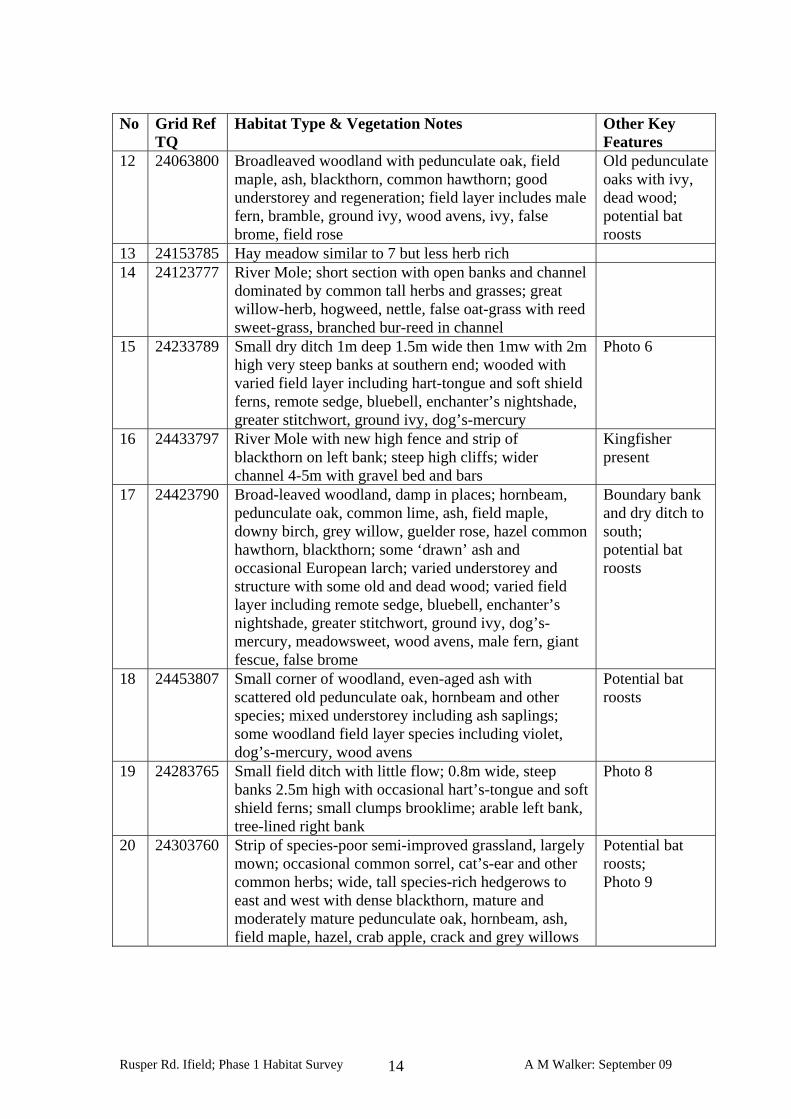
No Grid Ref
TQ Habitat Type & Vegetation Notes Other Key
Features 12 24063800 Broadleaved woodland with pedunculate oak, field
maple, ash, blackthorn, common hawthorn; good understorey and regeneration; field layer includes male fern, bramble, ground ivy, wood avens, ivy, false brome, field rose
Old pedunculate oaks with ivy, dead wood; potential bat roosts
13 24153785 Hay meadow similar to 7 but less herb rich 14 24123777 River Mole; short section with open banks and channel
dominated by common tall herbs and grasses; great willow-herb, hogweed, nettle, false oat-grass with reed sweet-grass, branched bur-reed in channel
15 24233789 Small dry ditch 1m deep 1.5m wide then 1mw with 2m high very steep banks at southern end; wooded with varied field layer including hart-tongue and soft shield ferns, remote sedge, bluebell, enchanter’s nightshade, greater stitchwort, ground ivy, dog’s-mercury
Photo 6
16 24433797 River Mole with new high fence and strip of blackthorn on left bank; steep high cliffs; wider channel 4-5m with gravel bed and bars
Kingfisher present
17 24423790 Broad-leaved woodland, damp in places; hornbeam, pedunculate oak, common lime, ash, field maple, downy birch, grey willow, guelder rose, hazel common hawthorn, blackthorn; some ‘drawn’ ash and occasional European larch; varied understorey and structure with some old and dead wood; varied field layer including remote sedge, bluebell, enchanter’s nightshade, greater stitchwort, ground ivy, dog’s-mercury, meadowsweet, wood avens, male fern, giant fescue, false brome
Boundary bank and dry ditch to south; potential bat roosts
18 24453807 Small corner of woodland, even-aged ash with scattered old pedunculate oak, hornbeam and other species; mixed understorey including ash saplings; some woodland field layer species including violet, dog’s-mercury, wood avens
Potential bat roosts
19 24283765 Small field ditch with little flow; 0.8m wide, steep banks 2.5m high with occasional hart’s-tongue and soft shield ferns; small clumps brooklime; arable left bank, tree-lined right bank
Photo 8
20 24303760 Strip of species-poor semi-improved grassland, largely mown; occasional common sorrel, cat’s-ear and other common herbs; wide, tall species-rich hedgerows to east and west with dense blackthorn, mature and moderately mature pedunculate oak, hornbeam, ash, field maple, hazel, crab apple, crack and grey willows
Potential bat roosts; Photo 9
Rusper Rd. Ifield; Phase 1 Habitat Survey A M Walker: September 09 14
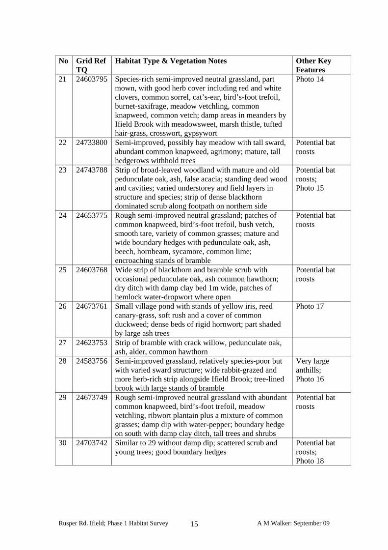
No Grid Ref
TQ Habitat Type & Vegetation Notes Other Key
Features 21 24603795 Species-rich semi-improved neutral grassland, part
mown, with good herb cover including red and white clovers, common sorrel, cat’s-ear, bird’s-foot trefoil, burnet-saxifrage, meadow vetchling, common knapweed, common vetch; damp areas in meanders by Ifield Brook with meadowsweet, marsh thistle, tufted hair-grass, crosswort, gypsywort
Photo 14
22 24733800 Semi-improved, possibly hay meadow with tall sward, abundant common knapweed, agrimony; mature, tall hedgerows withhold trees
Potential bat roosts
23 24743788 Strip of broad-leaved woodland with mature and old pedunculate oak, ash, false acacia; standing dead wood and cavities; varied understorey and field layers in structure and species; strip of dense blackthorn dominated scrub along footpath on northern side
Potential bat roosts; Photo 15
24 24653775 Rough semi-improved neutral grassland; patches of common knapweed, bird’s-foot trefoil, bush vetch, smooth tare, variety of common grasses; mature and wide boundary hedges with pedunculate oak, ash, beech, hornbeam, sycamore, common lime; encroaching stands of bramble
Potential bat roosts
25 24603768 Wide strip of blackthorn and bramble scrub with occasional pedunculate oak, ash common hawthorn; dry ditch with damp clay bed 1m wide, patches of hemlock water-dropwort where open
Potential bat roosts
26 24673761 Small village pond with stands of yellow iris, reed canary-grass, soft rush and a cover of common duckweed; dense beds of rigid hornwort; part shaded by large ash trees
Photo 17
27 24623753 Strip of bramble with crack willow, pedunculate oak, ash, alder, common hawthorn
28 24583756 Semi-improved grassland, relatively species-poor but with varied sward structure; wide rabbit-grazed and more herb-rich strip alongside Ifield Brook; tree-lined brook with large stands of bramble
Very large anthills; Photo 16
29 24673749 Rough semi-improved neutral grassland with abundant common knapweed, bird’s-foot trefoil, meadow vetchling, ribwort plantain plus a mixture of common grasses; damp dip with water-pepper; boundary hedge on south with damp clay ditch, tall trees and shrubs
Potential bat roosts
30 24703742 Similar to 29 without damp dip; scattered scrub and young trees; good boundary hedges
Potential bat roosts; Photo 18
Rusper Rd. Ifield; Phase 1 Habitat Survey A M Walker: September 09 15
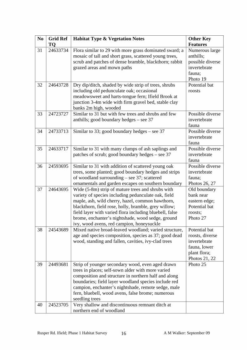
No Grid Ref
TQ Habitat Type & Vegetation Notes Other Key
Features 31 24633734 Flora similar to 29 with more grass dominated sward; a
mosaic of tall and short grass, scattered young trees, scrub and patches of dense bramble, blackthorn; rabbit grazed areas and mown paths
Numerous large anthills; possible diverse invertebrate fauna; Photo 19
32 24643728 Dry dip/ditch, shaded by wide strip of trees, shrubs including old pedunculate oak; occasional meadowsweet and harts-tongue fern; Ifield Brook at junction 3-4m wide with firm gravel bed, stable clay banks 2m high, wooded
Potential bat roosts
33 24723727 Similar to 31 but with few trees and shrubs and few anthills; good boundary hedges – see 37
Possible diverse invertebrate fauna
34 24733713 Similar to 33; good boundary hedges – see 37 Possible diverse invertebrate fauna
35 24633717 Similar to 31 with many clumps of ash saplings and patches of scrub; good boundary hedges – see 37
Possible diverse invertebrate fauna
36 24593695 Similar to 31 with addition of scattered young oak trees, some planted; good boundary hedges and strips of woodland surrounding – see 37; scattered ornamentals and garden escapes on southern boundary
Possible diverse invertebrate fauna; Photos 26, 27
37 24643695 Wide (5-8m) strip of mature trees and shrubs with variety of species including pedunculate oak, field maple, ash, wild cherry, hazel, common hawthorn, blackthorn, field rose, holly, bramble, grey willow; field layer with varied flora including bluebell, false brome, enchanter’s nightshade, wood sedge, ground ivy, wood avens, red campion, honeysuckle
Old boundary bank near eastern edge; Potential bat roosts; Photo 27
38 24543689 Mixed native broad-leaved woodland; varied structure, age and species composition, species as 37; good dead wood, standing and fallen, cavities, ivy-clad trees
Potential bat roosts, diverse invertebrate fauna, lower plant flora; Photos 21, 22
39 24493681 Strip of younger secondary wood, even aged drawn trees in places; self-sown alder with more varied composition and structure in northern half and along boundaries; field layer woodland species include red campion, enchanter’s nightshade, remote sedge, male fern, bluebell, wood avens, false brome; numerous seedling trees
Photo 25
40 24523705 Very shallow and discontinuous remnant ditch at northern end of woodland
Rusper Rd. Ifield; Phase 1 Habitat Survey A M Walker: September 09 16
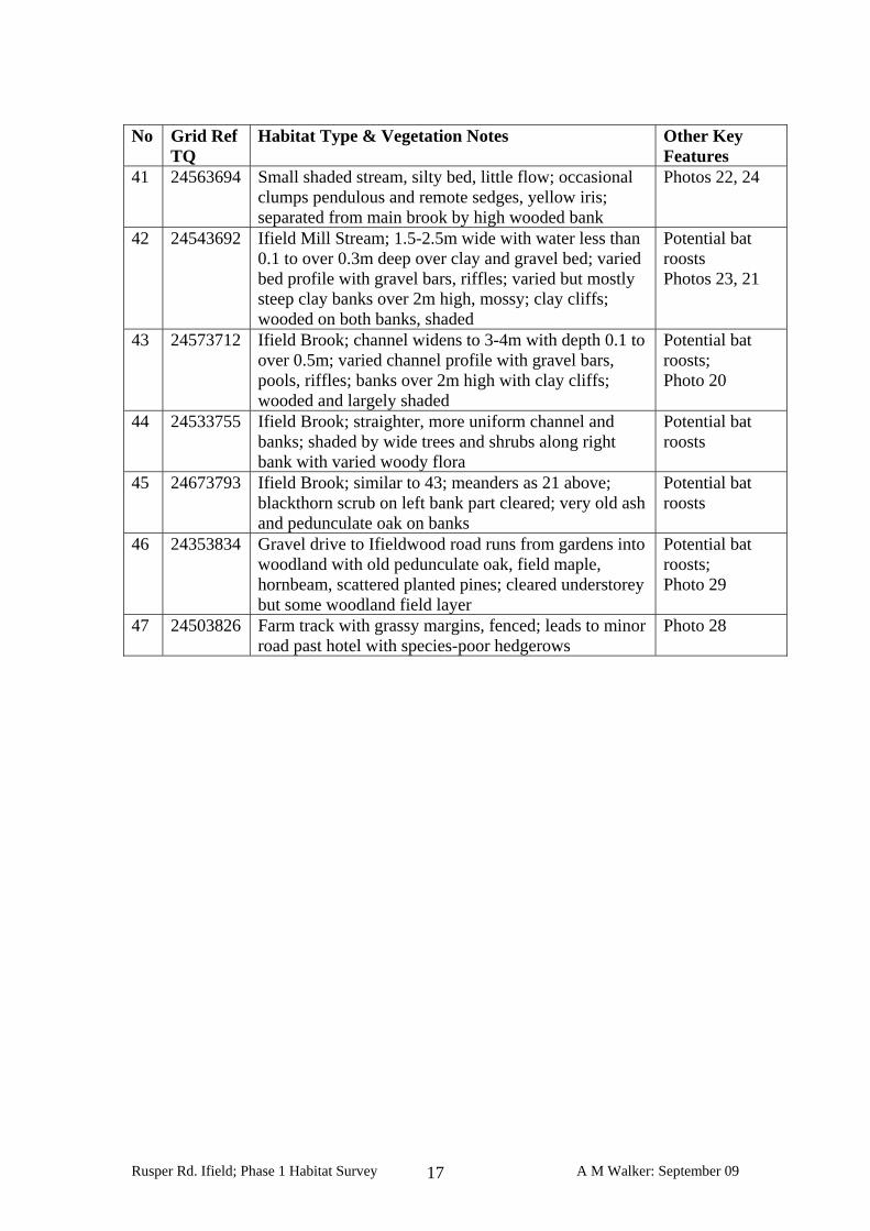
No Grid Ref
TQ Habitat Type & Vegetation Notes Other Key
Features 41 24563694 Small shaded stream, silty bed, little flow; occasional
clumps pendulous and remote sedges, yellow iris; separated from main brook by high wooded bank
Photos 22, 24
42 24543692 Ifield Mill Stream; 1.5-2.5m wide with water less than 0.1 to over 0.3m deep over clay and gravel bed; varied bed profile with gravel bars, riffles; varied but mostly steep clay banks over 2m high, mossy; clay cliffs; wooded on both banks, shaded
Potential bat roosts Photos 23, 21
43 24573712 Ifield Brook; channel widens to 3-4m with depth 0.1 to over 0.5m; varied channel profile with gravel bars, pools, riffles; banks over 2m high with clay cliffs; wooded and largely shaded
Potential bat roosts; Photo 20
44 24533755 Ifield Brook; straighter, more uniform channel and banks; shaded by wide trees and shrubs along right bank with varied woody flora
Potential bat roosts
45 24673793 Ifield Brook; similar to 43; meanders as 21 above; blackthorn scrub on left bank part cleared; very old ash and pedunculate oak on banks
Potential bat roosts
46 24353834 Gravel drive to Ifieldwood road runs from gardens into woodland with old pedunculate oak, field maple, hornbeam, scattered planted pines; cleared understorey but some woodland field layer
Potential bat roosts; Photo 29
47 24503826 Farm track with grassy margins, fenced; leads to minor road past hotel with species-poor hedgerows
Photo 28
Rusper Rd. Ifield; Phase 1 Habitat Survey A M Walker: September 09 17
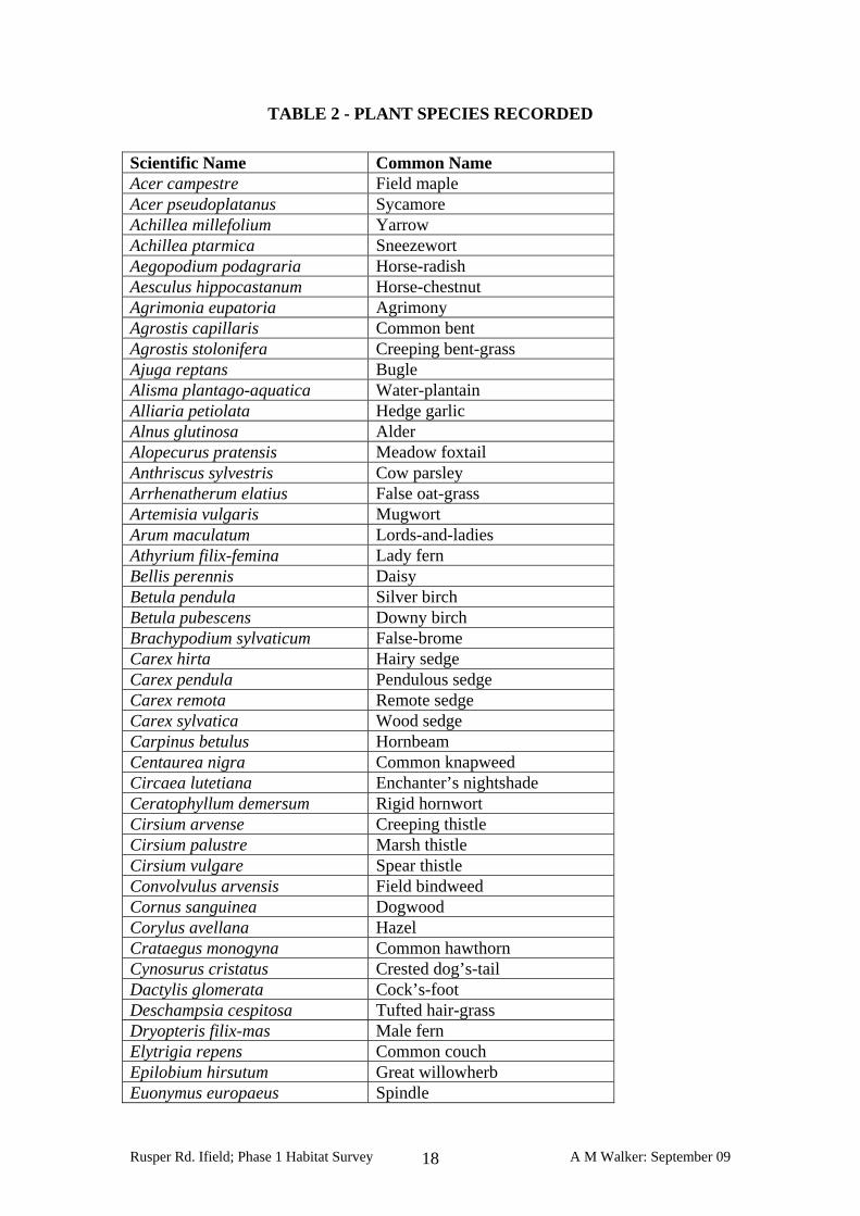
TABLE 2 - PLANT SPECIES RECORDED Scientific Name Common Name Acer campestre Field maple Acer pseudoplatanus Sycamore Achillea millefolium Yarrow Achillea ptarmica Sneezewort Aegopodium podagraria Horse-radish Aesculus hippocastanum Horse-chestnut Agrimonia eupatoria Agrimony Agrostis capillaris Common bent Agrostis stolonifera Creeping bent-grass Ajuga reptans Bugle Alisma plantago-aquatica Water-plantain Alliaria petiolata Hedge garlic Alnus glutinosa Alder Alopecurus pratensis Meadow foxtail Anthriscus sylvestris Cow parsley Arrhenatherum elatius False oat-grass Artemisia vulgaris Mugwort Arum maculatum Lords-and-ladies Athyrium filix-femina Lady fern Bellis perennis Daisy Betula pendula Silver birch Betula pubescens Downy birch Brachypodium sylvaticum False-brome Carex hirta Hairy sedge Carex pendula Pendulous sedge Carex remota Remote sedge Carex sylvatica Wood sedge Carpinus betulus Hornbeam Centaurea nigra Common knapweed Circaea lutetiana Enchanter’s nightshade Ceratophyllum demersum Rigid hornwort Cirsium arvense Creeping thistle Cirsium palustre Marsh thistle Cirsium vulgare Spear thistle Convolvulus arvensis Field bindweed Cornus sanguinea Dogwood Corylus avellana Hazel Crataegus monogyna Common hawthorn Cynosurus cristatus Crested dog’s-tail Dactylis glomerata Cock’s-foot Deschampsia cespitosa Tufted hair-grass Dryopteris filix-mas Male fern Elytrigia repens Common couch Epilobium hirsutum Great willowherb Euonymus europaeus Spindle
Rusper Rd. Ifield; Phase 1 Habitat Survey A M Walker: September 09 18
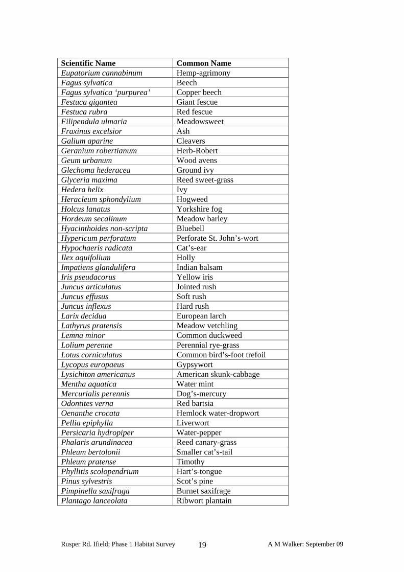
Scientific Name Common Name Eupatorium cannabinum Hemp-agrimony Fagus sylvatica Beech Fagus sylvatica ‘purpurea’ Copper beech Festuca gigantea Giant fescue Festuca rubra Red fescue Filipendula ulmaria Meadowsweet Fraxinus excelsior Ash Galium aparine Cleavers Geranium robertianum Herb-Robert Geum urbanum Wood avens Glechoma hederacea Ground ivy Glyceria maxima Reed sweet-grass Hedera helix Ivy Heracleum sphondylium Hogweed Holcus lanatus Yorkshire fog Hordeum secalinum Meadow barley Hyacinthoides non-scripta Bluebell Hypericum perforatum Perforate St. John’s-wort Hypochaeris radicata Cat’s-ear Ilex aquifolium Holly Impatiens glandulifera Indian balsam Iris pseudacorus Yellow iris Juncus articulatus Jointed rush Juncus effusus Soft rush Juncus inflexus Hard rush Larix decidua European larch Lathyrus pratensis Meadow vetchling Lemna minor Common duckweed Lolium perenne Perennial rye-grass Lotus corniculatus Common bird’s-foot trefoil Lycopus europaeus Gypsywort Lysichiton americanus American skunk-cabbage Mentha aquatica Water mint Mercurialis perennis Dog’s-mercury Odontites verna Red bartsia Oenanthe crocata Hemlock water-dropwort Pellia epiphylla Liverwort Persicaria hydropiper Water-pepper Phalaris arundinacea Reed canary-grass Phleum bertolonii Smaller cat’s-tail Phleum pratense Timothy Phyllitis scolopendrium Hart’s-tongue Pinus sylvestris Scot’s pine Pimpinella saxifraga Burnet saxifrage Plantago lanceolata Ribwort plantain
Rusper Rd. Ifield; Phase 1 Habitat Survey A M Walker: September 09 19
Scientific Name Common Name Plantago major Greater plantain Poa annua Annual meadow-grass Poa trivialis Rough meadow-grass Polystichum setiferum Soft shield-fern Potentilla reptans Creeping cinquefoil Primula vulgaris Primrose Prunella vulgaris Self-heal Prunus laurocerasus Cherry-laurel Prunus spinosa Blackthorn Pulicaria dysenterica Common fleabane Quercus robur Pedunculate oak Ranunculus acris Meadow buttercup Ranunculus repens Creeping buttercup Robinia pseudoacacia False-acacia Rosa arvensis Field rose Rosa canina agg. Dog rose Rubus fruticosus agg. Bramble Rumex acetosa Common sorrel Rumex crispus Curled dock Rumex obtusifolius Broad-leaved dock Rumex sanguineus Wood dock Salix caprea Goat willow Salix cinerea Grey willow Scrophularia auriculata Water figwort Senecio jacobaea Common ragwort Silene dioica Red campion Solanum dulcamara Bittersweet Stachys officinalis Betony Stachys sylvatica Hedge woundwort Stellaria holostea Greater stitchwort Taxus baccata Yew Tilia x europaea Common lime Torilis japonica Upright hedge-parsley Trifolium dubium Lesser trefoil Trifolium pratense Red clover Trifolium repens White clover Typha latifolia Bulrush Urtica dioica Nettle Veronica officinalis Heath speedwell Viburnum opulus Guelder rose Vicia cracca Tufted vetch Vicia sepium Bush vetch Vicia tetrasperma Smooth tare Viola sp. Violet species Nomenclature as in Stace (1991)2 2 Stace, C. (1991). ‘The New Flora of the British Isles’. Cambridge University Press.
Rusper Rd. Ifield; Phase 1 Habitat Survey A M Walker: September 09 20
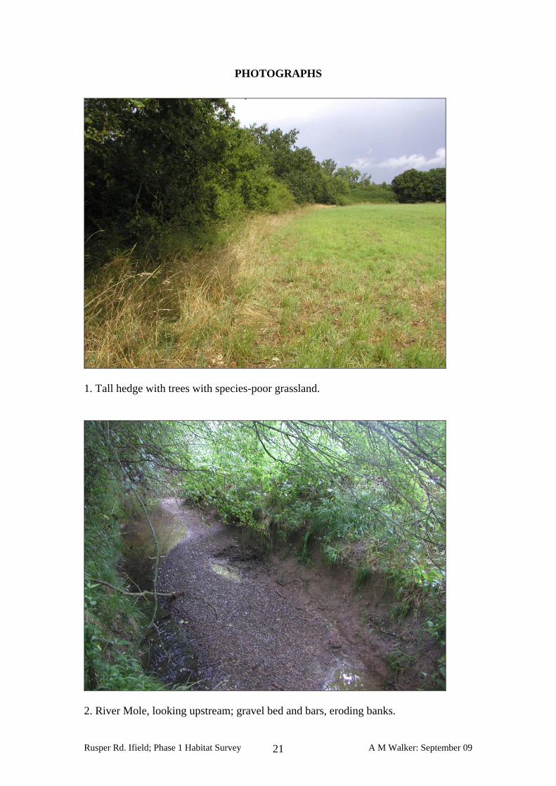
PHOTOGRAPHS
1. Tall hedge with trees with species-poor grassland.
2. River Mole, looking upstream; gravel bed and bars, eroding banks.
Rusper Rd. Ifield; Phase 1 Habitat Survey A M Walker: September 09 21
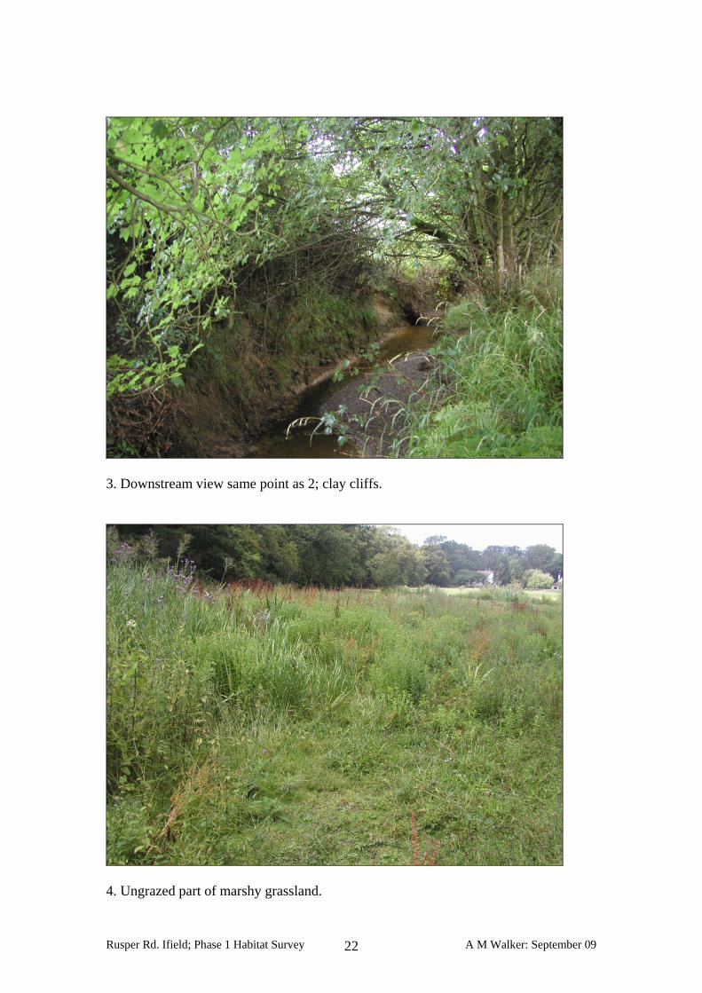
3. Downstream view same point as 2; clay cliffs.
4. Ungrazed part of marshy grassland.
Rusper Rd. Ifield; Phase 1 Habitat Survey A M Walker: September 09 22
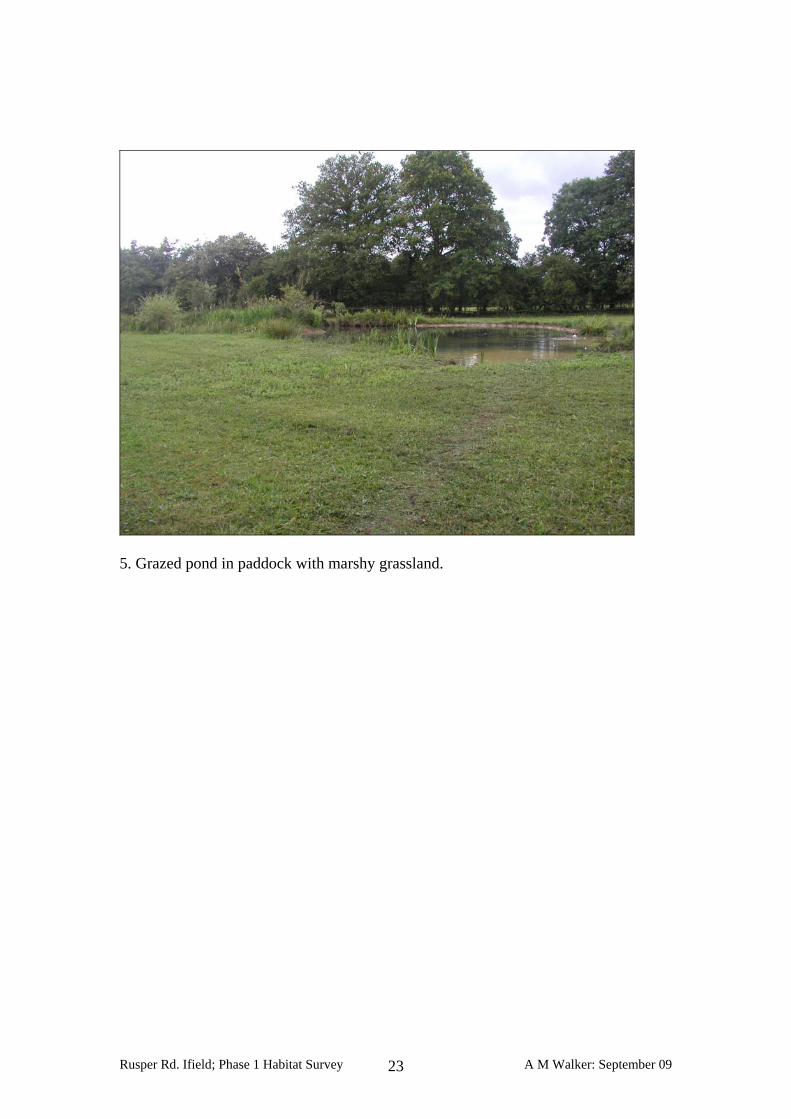
5. Grazed pond in paddock with marshy grassland.
Rusper Rd. Ifield; Phase 1 Habitat Survey A M Walker: September 09 23
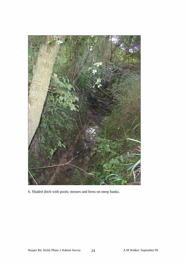
6. Shaded ditch with pools; mosses and ferns on steep banks.
Rusper Rd. Ifield; Phase 1 Habitat Survey A M Walker: September 09 24
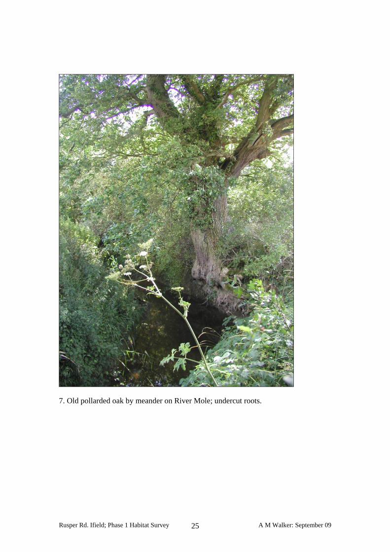
7. Old pollarded oak by meander on River Mole; undercut roots.
Rusper Rd. Ifield; Phase 1 Habitat Survey A M Walker: September 09 25
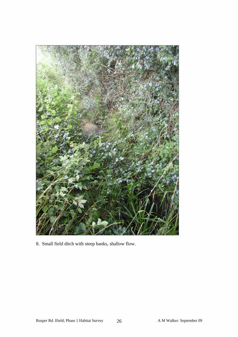
8. Small field ditch with steep banks, shallow flow.
Rusper Rd. Ifield; Phase 1 Habitat Survey A M Walker: September 09 26
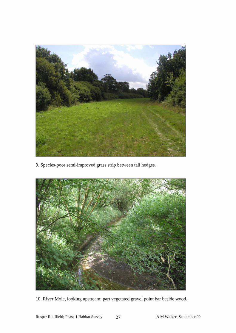
9. Species-poor semi-improved grass strip between tall hedges.
10. River Mole, looking upstream; part vegetated gravel point bar beside wood.
Rusper Rd. Ifield; Phase 1 Habitat Survey A M Walker: September 09 27

11. Siltier bars at downstream end of wood.
12. Area of possible site compound; improved permanent pasture.
Rusper Rd. Ifield; Phase 1 Habitat Survey A M Walker: September 09 28
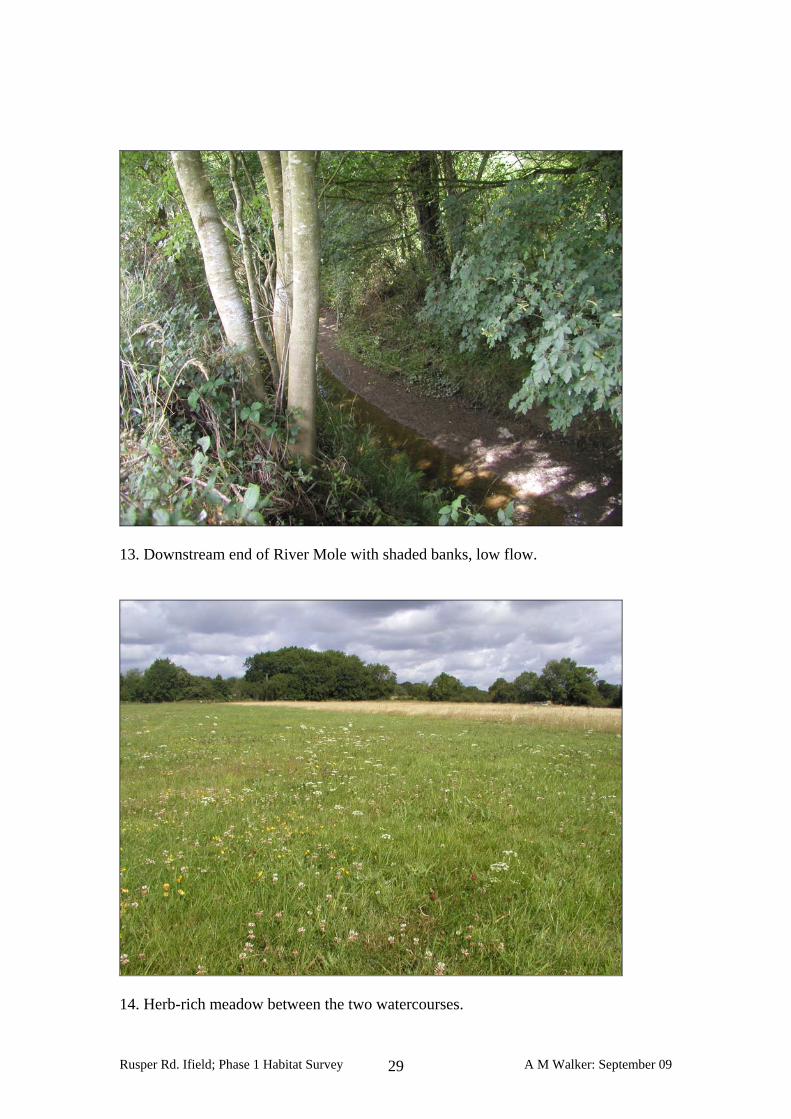
13. Downstream end of River Mole with shaded banks, low flow.
14. Herb-rich meadow between the two watercourses.
Rusper Rd. Ifield; Phase 1 Habitat Survey A M Walker: September 09 29
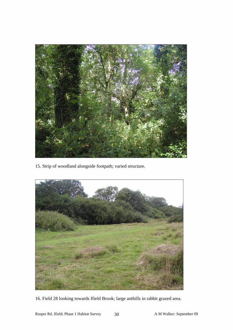
15. Strip of woodland alongside footpath; varied structure.
16. Field 28 looking towards Ifield Brook; large anthills in rabbit grazed area.
Rusper Rd. Ifield; Phase 1 Habitat Survey A M Walker: September 09 30
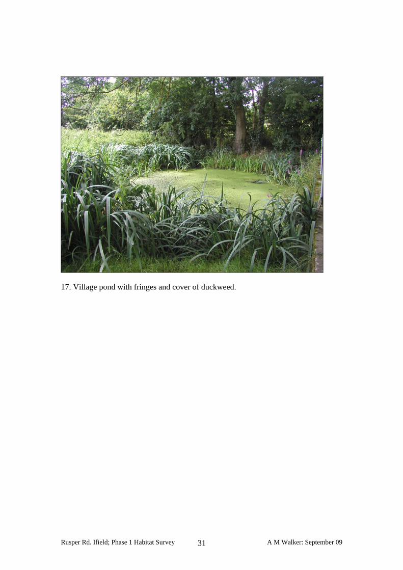
17. Village pond with fringes and cover of duckweed.
Rusper Rd. Ifield; Phase 1 Habitat Survey A M Walker: September 09 31
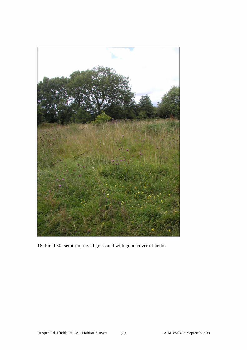
18. Field 30; semi-improved grassland with good cover of herbs.
Rusper Rd. Ifield; Phase 1 Habitat Survey A M Walker: September 09 32
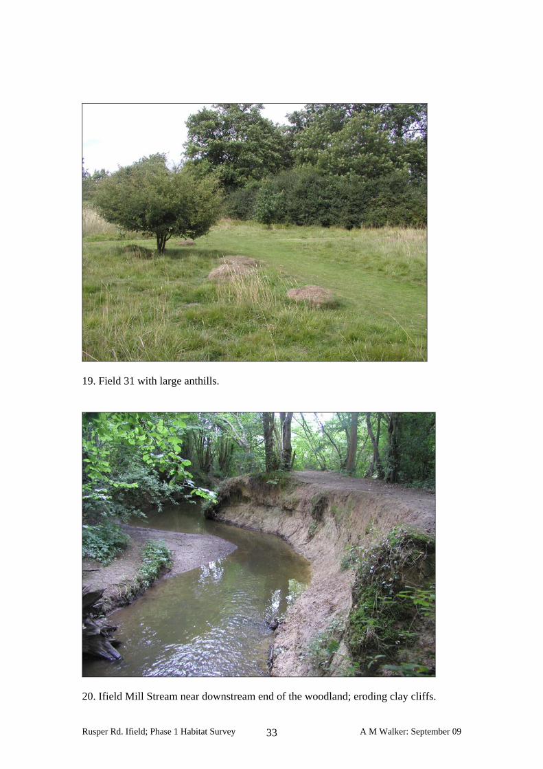
19. Field 31 with large anthills.
20. Ifield Mill Stream near downstream end of the woodland; eroding clay cliffs.
Rusper Rd. Ifield; Phase 1 Habitat Survey A M Walker: September 09 33
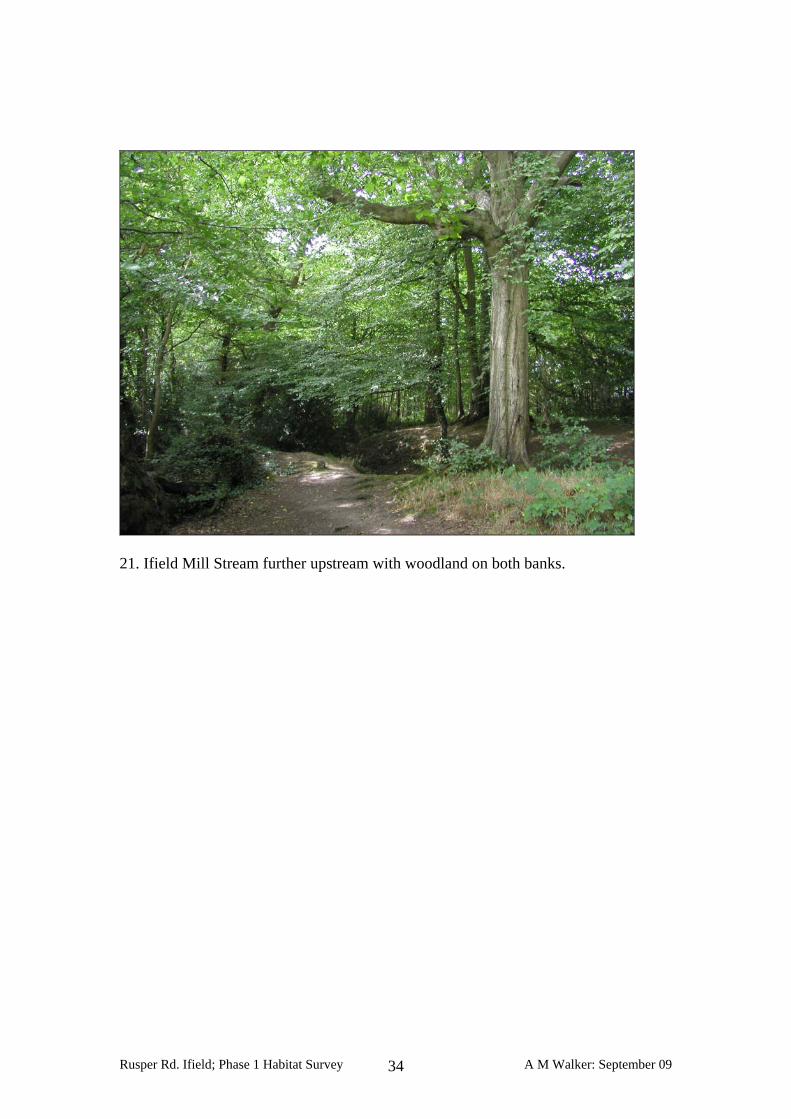
21. Ifield Mill Stream further upstream with woodland on both banks.
Rusper Rd. Ifield; Phase 1 Habitat Survey A M Walker: September 09 34
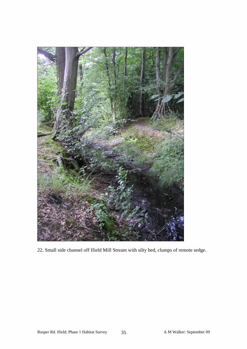
22. Small side channel off Ifield Mill Stream with silty bed, clumps of remote sedge.
Rusper Rd. Ifield; Phase 1 Habitat Survey A M Walker: September 09 35
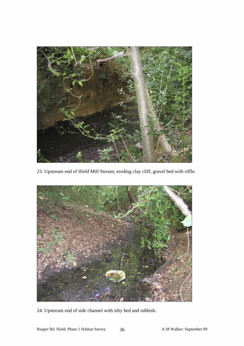
23. Upstream end of Ifield Mill Stream; eroding clay cliff, gravel bed with riffle.
24. Upstream end of side channel with silty bed and rubbish.
Rusper Rd. Ifield; Phase 1 Habitat Survey A M Walker: September 09 36

25. Secondary woodland of alder on left bank of Ifield Mill Stream.
26. Field 36 with mosaic of habitats.
Rusper Rd. Ifield; Phase 1 Habitat Survey A M Walker: September 09 37
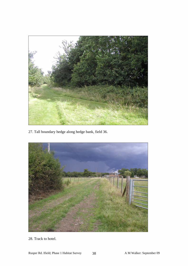
27. Tall boundary hedge along hedge bank, field 36.
28. Track to hotel.
Rusper Rd. Ifield; Phase 1 Habitat Survey A M Walker: September 09 38
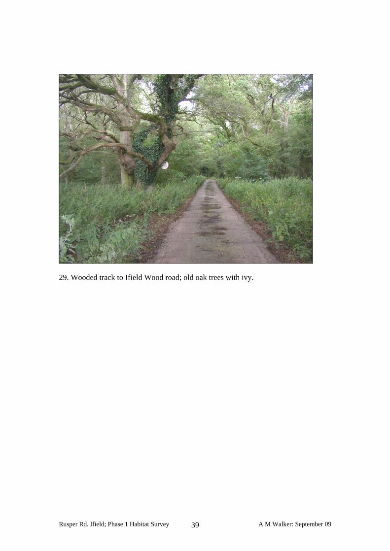
29. Wooded track to Ifield Wood road; old oak trees with ivy.
Rusper Rd. Ifield; Phase 1 Habitat Survey A M Walker: September 09 39