Embed Size (px)
Citation preview
HAL Id: hal-01870474https://hal.archives-ouvertes.fr/hal-01870474
Submitted on 7 Sep 2018
HAL is a multi-disciplinary open accessarchive for the deposit and dissemination of sci-entific research documents, whether they are pub-lished or not. The documents may come fromteaching and research institutions in France orabroad, or from public or private research centers.
L’archive ouverte pluridisciplinaire HAL, estdestinée au dépôt et à la diffusion de documentsscientifiques de niveau recherche, publiés ou non,émanant des établissements d’enseignement et derecherche français ou étrangers, des laboratoirespublics ou privés.
Distributed under a Creative Commons Attribution - NonCommercial - NoDerivatives| 4.0International License
Ruts of Gentrification: Breaking the Surface of Vienna’sChanging Cityscape
Markus Reisenleitner
To cite this version:Markus Reisenleitner. Ruts of Gentrification: Breaking the Surface of Vienna’s Changing Cityscape.Media Theory, Media Theory, 2018, Geospatial Memory, 2 (1), pp.281 - 306. �hal-01870474�
Special Issue: Geospatial Memory
Ruts of Gentrification:
Breaking the Surface of
Vienna’s Changing
Cityscape
MARKUS REISENLEITNER
York University, Canada
Media Theory
Vol. 2 | No. 1 | 281-306
© The Author(s) 2018
CC-BY-NC-ND
http://mediatheoryjournal.org/
Abstract
Last year, the city of Vienna celebrated the 150-year anniversary of the opening of the Ringstrasse, the central ring road that stands as symbol of the huge structural renewal that accompanied the transformation of the Habsburg empire’s capital into a rapidly growing modern city. The anniversary acquired poignancy on account of the way Vienna’s population is once again growing rapidly, with an estimated ¼ million people to be added to the city’s population over the next decade. While accommodating urban migrants was not a priority in Ringstrasse Vienna, and working class districts are not part of iconic mapped mediations, the current city council, a coalition of Social Democrats and the Green Party, studiously tries to avoid 19th-century urban modernity’s “mistakes” in their efforts to accommodate the growing population, and they let the Viennese, and the world, know. This time, GIS and digital mapping are mobilized for planning, mediating and communicating large-scale development and renewal projects. This paper looks at the mediations of three crucial sites of contemporary urban transformation in Vienna that mobilize the affordances of new technologies: “Loftcity,” a loft development cum cultural centre on the site of one of Vienna’s largest factories, the Ankerbrotfabrik; the transformation of the district surrounding Vienna’s new Hauptbahnhof; and Aspern, “Vienna’s Urban Lakeside,” a new satellite town promoted as a city of the future. By comparing the historical traces that remain in the mediations of these sites with their 19th-century counterparts, a geocritical reading of Vienna’s gentrification emerges that situates spatial practices in historically grown lines of connectivity, presaging and transcending traditional forms of classification, such as national divides or urban/suburban dichotomies.
Keywords
Faciality, gentrification, geomediation, holey space, Vienna
Media Theory
Vol. 2 | No. 1 | 2018 http://mediatheoryjournal.org/
282
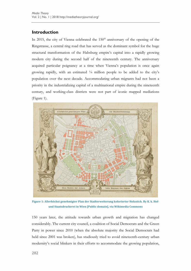
Introduction
In 2015, the city of Vienna celebrated the 150th anniversary of the opening of the
Ringstrasse, a central ring road that has served as the dominant symbol for the huge
structural transformation of the Habsburg empire’s capital into a rapidly growing
modern city during the second half of the nineteenth century. The anniversary
acquired particular poignancy at a time when Vienna’s population is once again
growing rapidly, with an estimated ¼ million people to be added to the city’s
population over the next decade. Accommodating urban migrants had not been a
priority in the industrializing capital of a multinational empire during the nineteenth
century, and working-class districts were not part of iconic mapped mediations
(Figure 1).
Figure 1: Allerhöchst genehmigter Plan der Stadterweiterung kolorierter Holzstich. By K. k. Hof-
und Staatsdruckerei in Wien [Public domain], via Wikimedia Commons
150 years later, the attitude towards urban growth and migration has changed
considerably. The current city council, a coalition of Social Democrats and the Green
Party in power since 2010 (when the absolute majority the Social Democrats had
held since 2001 was broken), has studiously tried to avoid nineteenth-century urban
modernity’s social blinkers in their efforts to accommodate the growing population,
REISENLEITNER | Ruts of Gentrification
283
and they let the Viennese, and the world, know. A wide array of geomediations, such
as digital maps, CAD-based architectural mock-ups and publications for
communicating current urban planning initiatives, is being mobilized for
disseminating these processes to the public.
This paper takes what is happening in 21st-century Vienna as a starting point to
reflect on a specific historical and spatial conjuncture of geomediated discourse, in
which digitally generated, visually mediated urban imaginaries are being deployed to
foster a discourse that encourages investment in locality, affectively as well as
financially. I am particularly interested in the surfaces that are being generated
through the affordances of digital tools used for place mediation, surfaces that I
argue flatten and smooth the historically constituted dynamics and affects of urban
habitats into clearly delineated areas of neighbourhood, community and belonging,
thereby establishing, materially as well as imaginatively, an agile and investment-
friendly time-space continuum. I will juxtapose this process to the counter-
hegemonic tenacity of ruts, unintended remnants of overlooked or deliberately
concealed habitual movement and directionality from the past that are part of
urbanity’s memoryscapes. My aim is to establish, in this preliminary probe into the
empirical context of a specific place with historical depth, how such an approach can
interrogate contemporary urban spatial practices and develop tools for an urban
critique of place-making that does justice to negotiations and assertions of complex
urban histories and memories and recuperates the vectors of mobility and
directionality that move imaginaries beyond the confines of identitarian spatiality. As
one will see, my approach is influenced by Deleuzian approaches to surfaces and
‘surfaciality’, refracted through the lens of Meaghan Morris’s readings of neoliberal
urbanism, which point towards the affordances of critique that an engagement with
spatial practices can open up.
My probe is focussed on the second decade of the 21st century, the period in
Vienna’s urban planning during which the 2015 masterplan (STEP 2015) was
completed and the 2025 plan (STEP 2025) emerged (Rosenberger, 2014; see also
Huitner, 2015: 131). Three sites serve as case studies: the Ankerbrot factory lofts
(“Loft City”), a loft development cum cultural centre on the site of one of Vienna’s
largest factories; the transformation of the district around the Central Train Station
Media Theory
Vol. 2 | No. 1 | 2018 http://mediatheoryjournal.org/
284
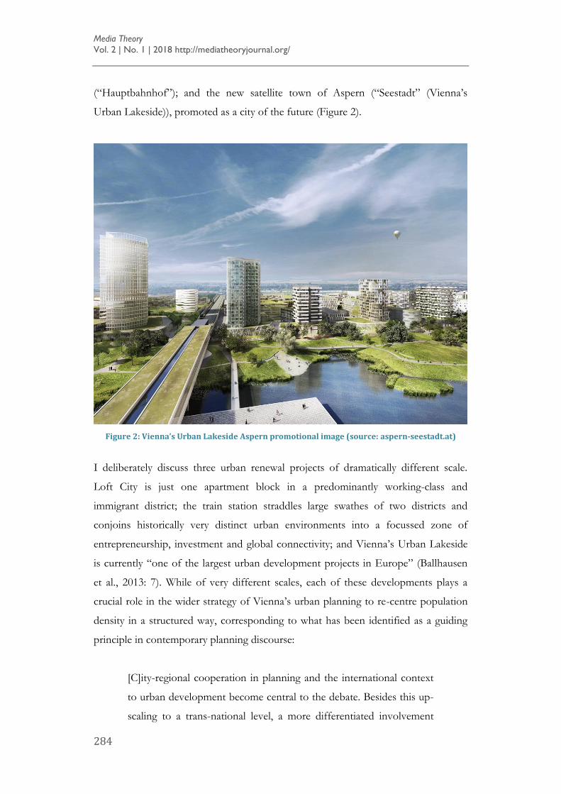
(“Hauptbahnhof”); and the new satellite town of Aspern (“Seestadt” (Vienna’s
Urban Lakeside)), promoted as a city of the future (Figure 2).
Figure 2: Vienna’s Urban Lakeside Aspern promotional image (source: aspern-seestadt.at)
I deliberately discuss three urban renewal projects of dramatically different scale.
Loft City is just one apartment block in a predominantly working-class and
immigrant district; the train station straddles large swathes of two districts and
conjoins historically very distinct urban environments into a focussed zone of
entrepreneurship, investment and global connectivity; and Vienna’s Urban Lakeside
is currently “one of the largest urban development projects in Europe” (Ballhausen
et al., 2013: 7). While of very different scales, each of these developments plays a
crucial role in the wider strategy of Vienna’s urban planning to re-centre population
density in a structured way, corresponding to what has been identified as a guiding
principle in contemporary planning discourse:
[C]ity-regional cooperation in planning and the international context
to urban development become central to the debate. Besides this up-
scaling to a trans-national level, a more differentiated involvement
REISENLEITNER | Ruts of Gentrification
285
with neighborhood development appears at the same time. Social
fragmentation becomes a pivotal element … [Planning] constructs
two scales of intervention independent from one another – the
neighborhood level and the European level (Huitner, 2015: 133).
Huitner identifies a conjuncture in which previous planning principles guided by the
tenets of a social welfare state have been superseded by a concern with investment
opportunities while maintaining an interest in social inclusivity and socially mixed
housing, which results in efforts to blur historically established boundaries of
districts that have also demarcated boundaries between social classes. Each of the
redevelopment projects thus triggers a re-constitution of urban memory, mediated by
representations that emphasize a European business context that is seen as the
enabling factor of the city’s prosperity. At the same time these mediations articulate
that context to the imaginaries of local community and neighbourhood into which
investments flow. In order to understand this two-pronged approach, we need to
look at the specific circumstances of the city’s planning and development of these
three sites. Proceeding from these circumstances, I will discuss the geomedial
framework into which these developments are inscribed and look at perspectives on
my example sites that might provide alternative geomedial approaches to the sites by
mobilizing vernacular temporalities that are not part of hegemonic spatial
representations.
Geomediating a Masterplan in Vienna
Quite exceptionally for a European city, Vienna reached its highest population
numbers (over 2 million) already before World War I, when it was still the capital of
the Habsburg’s Dual Monarchy. Significantly reduced in population after the first
World War, population growth throughout the 20th century, but especially after the
fall of the Iron Curtain in 1989, was accommodated by infill of areas that were not
densely populated by European standards, rather than by expansion into suburban
zones beyond the city limits. This growth was guided by a relatively powerful city
council with a tradition of taking the lead in master-planning urban development
since the inter-war years. Infill has targeted mostly working-class areas of the city,
which have generally been less densely populated since 1918. The three sites I focus
on can thus all be seen as part of a wider strategy of re-distributing population
Media Theory
Vol. 2 | No. 1 | 2018 http://mediatheoryjournal.org/
286
density in a structured way. They also blur historically established boundaries
between the bourgeoisie and the proletariat (Maderthaner and Musner, 2008),
boundaries that were established by an outer circumference road around the city as
well as by the Danube river. As such, these developments involve forms of
remembering that make the boundaries established by previous urban interventions –
especially the huge reconstruction efforts of the late nineteenth century – more
porous while establishing and promoting newly defined and demarcated
neighbourhoods.
Central Station (Hauptbahnhof)
This process of crossing, shifting and trying to obliterate traditional lines of
demarcation in the urban environment is noticeable in all three projects I am
discussing here, but perhaps most clearly advanced in and around the Central Train
Station, which serves as the centre for the development of c. 146 acres of urban
space, with the aim to develop by 2020 5,500 new apartments and office space for
20,000 people, as well as new hotels and infrastructure (Bönsch, 2015: 28). Mediated
by lavish publicity that includes stunning visuals, the powerful metaphor of
“bridging” the railway tracks that separated two very distinct parts of Vienna with a
development that is driven by high-rise office developments as well as condos and
shops has not eluded the planners. Futuristic architectural mock-ups, carefully
airbrushed panoramic shots and long-exposure photography that implies a fast-
moving crowd of smartly dressed people rushing to their next business deal are
conspicuously juxtaposed to historical photographs (in sepia-toned black-and-white)
of derelict warehouses on the wrong side of the tracks, firmly relegated to the past —
an ideological construction readily exposed as utopian or at least highly aspirational
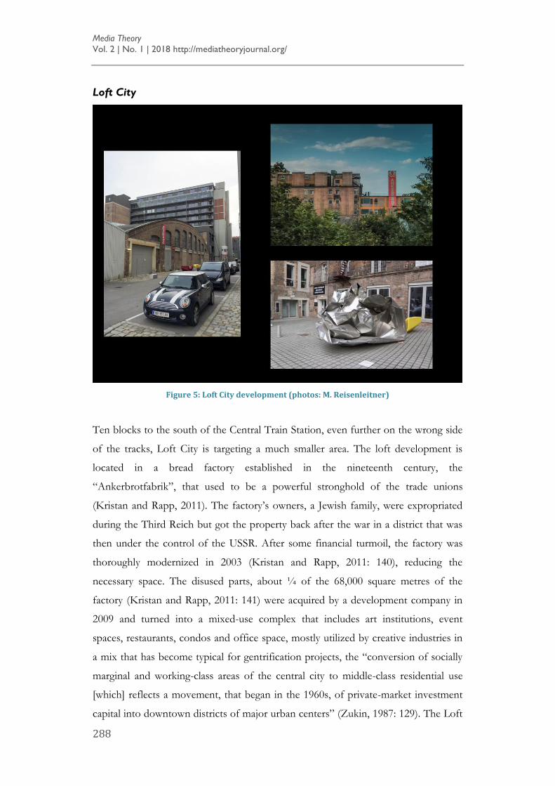
by a stroll around the area (Figure 3), but effective in training the eye for the
computer-generated cookie-cutter architecture that invariably accompanies urban
transformation at this scale (Figure 4).
Vectors of directionality are powerfully mapped onto the new development by one
of the historically most potent symbols of connectivity in the city of modernity, the
railway lines, which are shown to link Vienna to recognizable business destinations in
Europe, such as Paris, as well as Eastern European destinations, such as Budapest,
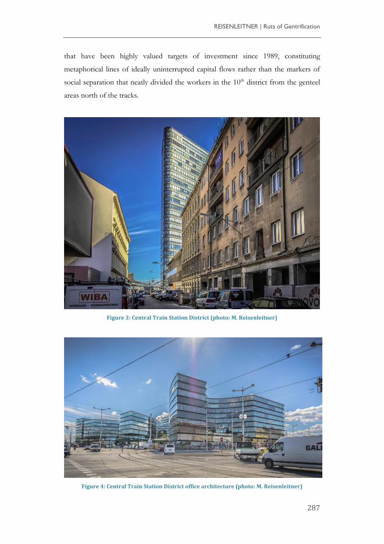
REISENLEITNER | Ruts of Gentrification
287
that have been highly valued targets of investment since 1989, constituting
metaphorical lines of ideally uninterrupted capital flows rather than the markers of
social separation that neatly divided the workers in the 10th district from the genteel
areas north of the tracks.
Figure 3: Central Train Station District (photo: M. Reisenleitner)
Figure 4: Central Train Station District office architecture (photo: M. Reisenleitner)
Media Theory
Vol. 2 | No. 1 | 2018 http://mediatheoryjournal.org/
288
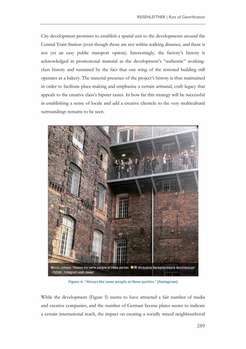
Loft City
Figure 5: Loft City development (photos: M. Reisenleitner)
Ten blocks to the south of the Central Train Station, even further on the wrong side
of the tracks, Loft City is targeting a much smaller area. The loft development is
located in a bread factory established in the nineteenth century, the
“Ankerbrotfabrik”, that used to be a powerful stronghold of the trade unions
(Kristan and Rapp, 2011). The factory’s owners, a Jewish family, were expropriated
during the Third Reich but got the property back after the war in a district that was
then under the control of the USSR. After some financial turmoil, the factory was
thoroughly modernized in 2003 (Kristan and Rapp, 2011: 140), reducing the
necessary space. The disused parts, about ¼ of the 68,000 square metres of the
factory (Kristan and Rapp, 2011: 141) were acquired by a development company in
2009 and turned into a mixed-use complex that includes art institutions, event
spaces, restaurants, condos and office space, mostly utilized by creative industries in
a mix that has become typical for gentrification projects, the “conversion of socially
marginal and working-class areas of the central city to middle-class residential use
[which] reflects a movement, that began in the 1960s, of private-market investment
capital into downtown districts of major urban centers” (Zukin, 1987: 129). The Loft
REISENLEITNER | Ruts of Gentrification
289
City development promises to establish a spatial axis to the developments around the
Central Train Station (even though those are not within walking distance, and there is
not yet an easy public transport option). Interestingly, the factory’s history is
acknowledged in promotional material as the development’s “authentic” working-
class history and sustained by the fact that one wing of the restored building still
operates as a bakery. The material presence of the project’s history is thus maintained
in order to facilitate place-making and emphasize a certain artisanal, craft legacy that
appeals to the creative class’s hipster tastes. In how far this strategy will be successful
in establishing a sense of locale and add a creative clientele to the very multicultural
surroundings remains to be seen.
Figure 6: “Always the same people at these parties.” (Instagram)
While the development (Figure 5) seems to have attracted a fair number of media
and creative companies, and the number of German license plates seems to indicate
a certain international reach, the impact on creating a socially mixed neighbourhood
Media Theory
Vol. 2 | No. 1 | 2018 http://mediatheoryjournal.org/
290
remains to be determined. Gentrification stormtroopers’ instagrammed take on the
situation includes posts such as “always the same people at these parties” (Figure 6);
presumably the people who can afford to live in the lofts and their friends. It is
unclear what kind of place-making the deliberate evocation of such a history will
induce.
Urban Lakeside (“Seestadt”)
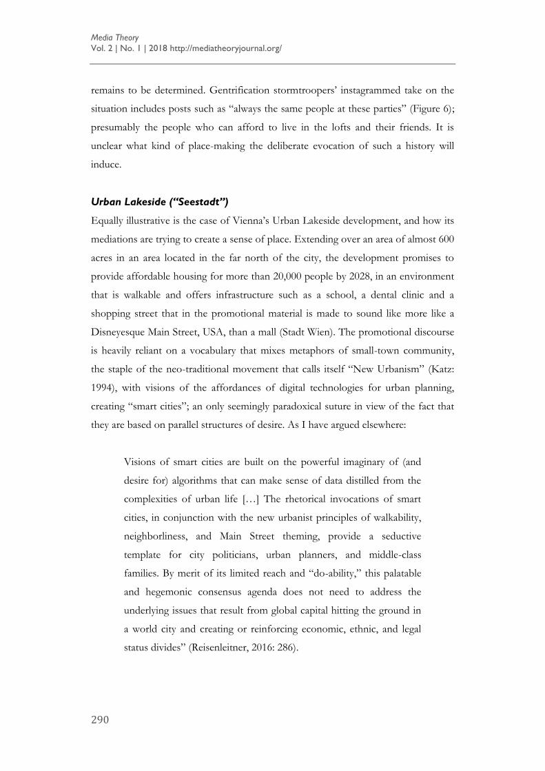
Equally illustrative is the case of Vienna’s Urban Lakeside development, and how its
mediations are trying to create a sense of place. Extending over an area of almost 600
acres in an area located in the far north of the city, the development promises to
provide affordable housing for more than 20,000 people by 2028, in an environment
that is walkable and offers infrastructure such as a school, a dental clinic and a
shopping street that in the promotional material is made to sound like more like a
Disneyesque Main Street, USA, than a mall (Stadt Wien). The promotional discourse
is heavily reliant on a vocabulary that mixes metaphors of small-town community,
the staple of the neo-traditional movement that calls itself “New Urbanism” (Katz:
1994), with visions of the affordances of digital technologies for urban planning,
creating “smart cities”; an only seemingly paradoxical suture in view of the fact that
they are based on parallel structures of desire. As I have argued elsewhere:
Visions of smart cities are built on the powerful imaginary of (and
desire for) algorithms that can make sense of data distilled from the
complexities of urban life […] The rhetorical invocations of smart
cities, in conjunction with the new urbanist principles of walkability,
neighborliness, and Main Street theming, provide a seductive
template for city politicians, urban planners, and middle-class
families. By merit of its limited reach and “do-ability,” this palatable
and hegemonic consensus agenda does not need to address the
underlying issues that result from global capital hitting the ground in
a world city and creating or reinforcing economic, ethnic, and legal
status divides” (Reisenleitner, 2016: 286).
REISENLEITNER | Ruts of Gentrification
291
Mediations of Vienna’s Urban Lakeside unsurprisingly include staples of urban
utopias such as pop-up dorms (Czaja, 2017), self-driving busses (“Pilotprojekt ohne
Pilot”, 2017), etc. Again, a sense of place has not materialized so far, despite PR and
branding machines operating in high gear (and a subway that now runs more
frequently). This development is a first major attempt to extend the city outwards,
rather than through infill, and thus a “city of the future” discourse, accompanied by a
strong undercurrent of avoiding planning mistakes of the past, translates into a
breathless tsunami of geomediating the area through a consensus visuality of
streamline moderne that literally has no time for the area’s many pasts.
Breaking the Surface
What my three examples demonstrate is a mediation of Vienna’s contemporary
urban geography that articulates investment in locality to transnational flows, an
articulation that establishes a particular vision of economic, i.e. immaterial and
abstract, lines of connectivity as an imaginary in which investment in locale is
embedded and grounded. It is tempting to debunk the mediation of these three sites
through the lens of a symptomatic reading or critique of official remembering and
spatial practices of meaning-making in these carefully selected and curated histories
that are intended to sell. However, this is not my intent here. Rather, my interest is
not only to challenge the flattening of complex historical narratives into easily
commodifiable space branding, but to conceptualize how memories of in-between
spaces and vectors of mobility can be salvaged from being incorporated into the
smoothly moving flows of (property) development discourse. I am particularly
interested in material traces that disrupt, interrupt or break the surface of urban
planning imaginaries and the common understanding – or, in Kara Keeling’s take on
Deleuze and Gramsci, visual “clichés” (Keeling, 2007: 14) – of the trajectories into
which capital-friendly urban planning supposedly needs to be inscribed. What is
established through clichés is “common sense,” which “refers simultaneously to a
shared set of motor contrivances that affect subjective perception and to a collective
set of memory-images that includes experiences, knowledges, traditions, and so on
and that are available to memory during perception” (Keeling, 2007: 14). The visual
clichés afforded by the digital tools of geomediation are clearly linked to a
contemporary consensus agenda of urban planning (and living) that is capital-friendly
Media Theory
Vol. 2 | No. 1 | 2018 http://mediatheoryjournal.org/
292
while de-emphasizing the messiness and complexities of the movement of people
and the complex geo-histories of which those movements are an expression.
What is established in the current conjuncture is a hegemonic form of understanding
spatial practices that originates with, but reaches beyond, property discourse. For
example, recent geo-critical approaches to the mediation of space in film, literature
and popular culture, such as Bertrand Westphal’s géocritique and his disciple and
translator Robert Tally’s elaboration of a “literary cartography”, have re-invigorated a
spatial turn in the humanities that is supported by the ease and accessibility of digital
map-making tools, which has in turn led to a proliferation of projects that
cartographically visualize film locations, plots of novels, and biographical
information. While these approaches have produced interesting insights into
narratives that constitute urban imaginaries, they also tend to be caught up in
flattening the representation of slippery and complex cultural phenomena that have
complicated sensitive and contested pasts. In the fields of Urban Humanities and
Memory Studies, recent mobilizations of the spatial turn have highlighted the
intricate interplay between imaginaries that are premised on representations (and
misrepresentations) of the historically constituted texture of a city on one hand, and
processes of urban planning and change. While the gentrification discourse has
become a lightning rod for struggles over the right to the city in the 21st century, its
specific manifestations are composite and situated processes and negotiations over
the preservation, re-constitution, erasure or even production of histories and
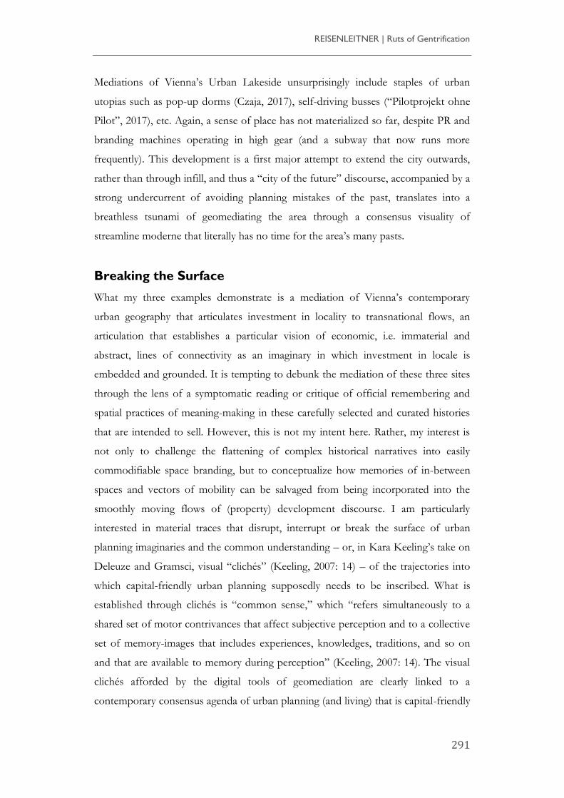
memories materialized in urban environments. When Disney imagineered the New
Urbanist town of Celebration, Florida, urban planners were tasked with inventing a
“back story,” i.e. a history that could ex nihilo constitute community for an urban
development in the Florida swamps.
[A] key part of the Imagineering process is developing what is called a
“backstory” for the product, the mythological history that provides a
focus as the development proceeds. Concocting a backstory for a
town did not seem too different from concocting one for a new ride.
But some of the ideas were ripe. At one point, the Imagineers
suggested the tale of a city rising from the ashes of General
REISENLEITNER | Ruts of Gentrification
293
Sherman’s march across the South, though the fact that he never set
foot in Florida did not seem to matter. In the end, the more
pragmatic development people recognized that the town would not
be a ride or a movie, but a real place (Frantz and Collins, 1999: 52).
Figure 7: Alligator in Celebration, Florida (photo: S. Ingram)
It’s impressive the effects a few well-placed alligators can have (Figure 7) on creating
a sense of place! However, despite efforts such as Todd Presner’s “thick mapping”
of Berlin and Los Angeles in Hypercities (Presner et al., 2014) and Google Earth’s
historical timelines, the affordances of digital mapping tools tend to hegemonically
produce an ever-more detailed landscape of what de Certeau has termed a “concept
city,” in which “[p]erspective vision and prospective vision constitute the twofold
projection of an opaque past and an uncertain future onto a surface that can be dealt
with” (1984: 93), rather than what he calls an “urban practice.” Using such a surface
as a point of reference for urban imaginaries, whether in the form of historical
preservation, office and condo development, or strategic infrastructure investment,
can thus be seen as continuing what de Certeau has labelled the “erasure of the
itineraries” (de Certeau, 1984: 121), rather than the potential of human connectivity
and mediation that de Certeau’s in-between spaces (1984: 127) could offer. Reducing
historically constituted spatial assemblages to smooth digital surfaces constitutes a
Media Theory
Vol. 2 | No. 1 | 2018 http://mediatheoryjournal.org/
294
strategy for representing the future in such a way that masks its uncertainty, trying to
keep people in their places, or move them from inappropriate places, or prevent
them from occupying spaces where they are not wanted or are in the way, such as the
tent cities that still remain in the streets in between the gentrifying nodes in
Downtown LA, defying New Urbanist hipster localism in the global city’s
downtown. (There are no tent cities in Vienna, but a number of substandard
buildings in the Central Train Station area have been razed). Digital mapping tools
arguably have a propensity to seduce into a methodology of what Deleuze and
Guattari refer to, in A Thousand Plateaus, as tracing, a form of reproduction from
selection:
It is our view that genetic axis and profound structure are above all
infinitely reproducible principles of tracing. All of tree logic is a logic
of tracing and reproduction. […] Its goal is to describe a de facto
state, to maintain balance in intersubjective relations, or to explore an
unconscious that is already there from the start, lurking in the dark
recesses of memory and language. It consists of tracing, on the basis
of an overcoding structure or supporting axis, something that comes
ready-made. […] What distinguishes the map from the tracing is that
it is entirely oriented toward an experimentation in contact with the
real (Deleuze and Guattari, 1987: 12).
The same process of seduction can be found in the imaginary of big data and
derivative trading, which similarly builds on a streamlined and flattened image of the
past that is used for extrapolating the future.
The past is no longer the multiplicity of histories that is the spatial
[…] with all its happenstance juxtapositions and unintended
emergent effects but rather a resource for providing models that
serve as guarantors against the randomness and unpredictability of
the urban, simplified through what are fundamentally engineering
practices imposed on data as well as spaces, and serving as the
foundation of imposed and imposable social reform through a
REISENLEITNER | Ruts of Gentrification
295
particular (and equally limited) notion of community (Reisenleitner,
2016).
Following Deleuze and Guattari’s logic, the challenge of critique in a regime of
spatial practices built on the affordances of, in Deleuze and Guattari’s
conceptualisation, tracing tools is to transform cartographies into dynamic
assemblages that involve affect (cf. Petschke, 2017: 12) and constitute multiple lines
of flight for urban habitats. This means avoiding the binaries that so often riddle
critique.
Tempting as it might be, as we have seen in the Vienna case studies, it is not
particularly helpful to align hegemonic geomediations of urban locale with Jameson’s
seminal indictment against the “cultural dominant” (Jameson, 1984: 56) of
postmodernism, in which he finds “a new kind of flatness or depthlessness, a new
kind of superficiality in the most literal sense” (60), and which he connects to the
waning of affect and the dominance of the synchronic over the diachronic, in which
“our daily life, our psychic experience, our cultural languages are […] dominated by
categories of space rather than by categories of time, as in the preceding period of
high modernism proper” (64). Contrary to Jameson’s diagnosis, the discursive
formations that geomediate spatial practices in my examples are underpinned by the
assertion of linear temporalities that determine both affective and capital investment
into those spaces, rather than simple synchronicity. Movement and flow are not
denied but rather emphasized, albeit in smooth and clearly delineated ways, just like
the stock market always supposedly moves “forward” and investment grows. Such
spatial practices are addressed in Deleuze and Guattari’s “Treatise on Nomadology”
when they emphasize the complicity of both striated and smooth spaces:
One of the fundamental tasks of the State is to striate the space over
which it reigns, or to utilize smooth spaces as a means of
communication in the service of striated space. It is a vital concern of
every State not only to vanquish nomadism but to control migrations
and, more generally, to establish a zone of right over an entire
‘exterior’, over all the flows traversing the ecumenon. If it can help it,
the State does not dissociate itself from a process of capture of flows,
Media Theory
Vol. 2 | No. 1 | 2018 http://mediatheoryjournal.org/
296
money or capital, etc. There is still a need for fixed paths in well-
defined directions, which restrict speed, regulate circulation, relativize
movement, and measure in detail the relative movements of subjects
and objects (Deleuze and Guattari, 1987: 385–6).
What Deleuze and Guattari have to offer as a way out of the co-optation of smooth
space is, via a still from Eisenstein’s Strike (413), the concept of “holey space”:
Holey space appears alongside ‘smooth’ and ‘striated’ space […] as
Deleuze and Guattari's prescient warning about the tendency to read
those two categories as self-evidently emancipatory or repressive.
While the state apparatus perhaps worked initially primarily in the
mode of striating space, the neoliberal war machine that reigns today
has just as much interest in smooth space, in terms of swarming
militarism, the global gaze of surveillance technology, and frictionless
capital flows. Holey space, as a substance of content, compels
theorists to consider the ways in which specific assemblages negotiate
the mixture of smooth and striated space that characterizes any
power formation. […] Whereas smooth and striated spaces are
substances of expression, holey space is rather literally about the
intermediate and ambivalent subsoil in and through which
apparatuses of capture struggle with nomadic assemblages (Hantel,
2012).
The concept of holey spaces connects to an earlier discussion in A Thousand Plateaus
in which a black hole is introduced as the site of “consciousness, passion and
redundancies” (167) against the white wall of faciality:
The face constructs the wall that the signifier needs in order to
bounce off of; it constitutes the wall of the signifier, the frame or
screen. The face digs the hole that subjectification needs in order to
break through; it constitutes the black hole of subjectivity as
REISENLEITNER | Ruts of Gentrification
297
consciousness or passion, the camera, the third eye (Deleuze and
Guattari, 1987: 168).
Meaghan Morris mobilizes Deleuze and Guattari’s concept of ‘faciality’, which
“shapes in their work a theory of ‘majority’” (Morris, 1998: 125), to examine “the
relentlessly redundant and self-signifying corporate architecture” of Sydney’s CBD.
Her masterful détournements of A Thousand Plateaus and de Certeau’s spatial stories
via her readings of King Kong and the “Human Fly” in the movie A Spire (1988) lay
out an instance of practicing place as a form of vernacular criticism (Morris, 1998:
157), with a symbolic form of temporary occupation as a spatial practice that
interrupts the logic of the corporate face of the business tower by exerting
movements that are not contained in the striations of corporate and state control.
While Morris’s reading provides a convincing example of acknowledging the
complexities of the stakes in negotiating spatial practices in the contemporary city, I
do not claim that the affordances of digital tools geomediating Vienna’s
masterplanning should simply be read as equivalents or extensions of the smooth
tower surfaces of 1990s global corporate architecture. What Morris calls, with
reference to Deleuze and Guattari’s concept of ‘haecceities’, “individuating
intensities” (Morris, 1998: 124), necessarily alerts us to crucial differences in the
historical and spatial conjunctures of Sydney in the 1990s and Vienna in the 2010s.
Morris draws our attention to the gendered home/voyage opposition in the
imaginary of a colonial settler nation, Australia, that renders movement masculine
and relates it to linear notions of time while relegating home to static and cyclical
temporalities that are rendered feminine.
What is at stake in the contemporary re-imagineering of Vienna, by contrast, needs
to be understood in the context of a national discourse that is inimical to
immigration and a city that tries to practice place as a home for affective and capital
investment in stability (rather than movement) while remaining married to the
seductive discourses of flows and growth. The dominant imaginary is not one that
juxtaposes the smooth flow of capital to the perceived stasis of home-making.
Rather, local investment is represented as being predicated on the articulation of
locale and circumscription of people’s movement to the circulation of global capital
Media Theory
Vol. 2 | No. 1 | 2018 http://mediatheoryjournal.org/
298
on which the real estate economy is built, in other words: on controlled movement,
steady movement, juxtaposed to the irregular und unpredictable rhythms of
migration and migrants’ and migrations’ uneven histories. In this conjuncture, an
anti-hegemonic reading of memoryscapes that performs what Morris calls ‘vernacular
criticism’ requires attending to the unruly forms of mobility that resist the seamless
sutures of digital surfaces, historically saturated interruptions that challenge the
representations of dominant flows of time (as teleological progress towards an ideal
community) and capital/property (as investment and growth). What seems to be at
stake in such an approach is identifying the holey space that punctures the surface of
geomedia as a visual regime of common sense that has “found ways of moving with
relative ease by affirming aspects of common sense” (Keeling, 2007: 4). If we accept
that geomedia’s hegemonic assemblages resemble film in being “defined by [an]
‘internalized’ relation with money” (Keeling, 2007: 17), we need to look for tokens of
movement that defy this cliché.
In his exploration of critical art in The Emancipated Spectator, Jacques Rancière
introduces the powerful metaphor of a visual wound or scar in his discussion of a
photograph by the French artist Sophie Ristelhueber of a bird’s eye perspective of an
Israeli roadblock on a Palestinian road as a form of resistance of the viewer’s
anticipation:
She has photographed not the emblem of the war, but the wounds
and scars it imprints on a territory. In this way, she perhaps effects a
displacement of the exhausted affect of indignation to a more
discreet affect, an affect of indeterminate effect – curiosity, the desire
to see closer up. I speak here of curiosity, and above I spoke of
attention. These are in fact affects that blur the false obviousness of
strategic schemata; they are dispositions of the body and the mind
where the eye does not know in advance what it sees and thought
does not know what it should make of it (Rancière, 2011: 104).
Wounds or scars invariably point to the violent nature of the movement and/or
temporality that caused them. I do not deny that such violence is often what is at
REISENLEITNER | Ruts of Gentrification
299
stake in re-membering, in undoing smooth representations of historicity, but an
interruption through a wound is not the only possible form of subverting surfaciality.
What needs to be uncovered in a more general sense is what Homi Bhabha calls a
“minority discourse” that is set against the commonsensical form of singular
temporality inscribed in geomedia representations:
Minority discourse sets the act of emergence in the antagonistic in-
between of image and sign, the accumulative and the adjunct, presence
and proxy. It contests genealogies of ‘origin’ that lead to claims for
cultural supremacy and historical priority … Now there is no reason
to believe that such marks of indifference cannot inscribe a ‘history’
of the people or become the gathering points of political solidarity.
They will not, however, celebrate the monumentality of historicist
memory, the sociological totality of society, or the homogeneity of
cultural experience. The discourse of minority reveals the
insurmountable ambivalence that structures the equivocal movement
of historical time (Bhabha, 1994: 157).
While Bhabha presents these considerations in the context of his discussion of
writing the nation, the principle obtains for any conjuncture in which locality needs
to be released from the controlling forces of a dominant historical and controlling
flow – in my case the specific temporality of investment – and restored to the
multiple minoritarian temporalities that are able to accomplish the vernacular
criticism Morris demonstrates in the Australian context. Rather than focussing on the
violence of scars and wounds, as Rancière does, I propose, for the specific
conjuncture I am addressing, to expose less spectacular interruptions of surfaciality,
namely the ruts, understood both literally as furrows and indentations, and
metaphorically as routines and patterns, i.e. as habitual imprints of, and produced by,
movement and directionality in memory spaces that are neither obvious nor
spectacularly disruptive yet prone to disturb or jar the mappability of urban space
because they constitute sites of “the hybridity of histories and the displacement of
narratives” (Bhabha, 1994: 169), revealing historical vectors that are camouflaged
under the predictability of maps, graphs and computer-assisted design. I argue that
turning our attention to these imprints can serve a similar critical intervention to the
Media Theory
Vol. 2 | No. 1 | 2018 http://mediatheoryjournal.org/
300
kind of challenges to contemporary urban practices through visual culture identified
in Jordan and Lindner (2016).
Interruptions
I will now return to my three examples to identify some of those ruts that point us
towards alternative vectors of directionality, and thus alternative temporalities of the
local that resist the linear makeovers of geomediated gentrification and investment
discourse.
In the case of the Hauptbahnhof, this would seem most obvious. The project is
centred around a line of transportation with multiple lines of connectivity that
cannot easily be contained. As a railway station, the Hauptbahnhof necessarily needs
to maintain an uneasy relationship with the dynamics of movement provided by the
railway, movements of immigrants and refugees into, and deportations of the
marginalized and discriminated out of, the city (at times, such as during the
deportations of Jews during the Third Reich, with lethal consequences for those
concerned). While PR maps currently tend to emphasize train connections to
business centres in Western and Eastern Europe, the lines to the South that were
historically the station’s main lines are mainly absent from geomediation. Yet it was
those lines that the “guest workers” from Yugoslavia arrived by for decades, starting
in the 1970s. The Syrian refugees who were stranded in 2015 and 2016 at the
Hauptbahnhof were also en route from the Balkans and Hungary, along the same
lines that had been established by an empire whose traces are still there if you know
where to look for them.
In this case, it is actually difficult to overlook the vectors of migration that have
inscribed themselves into the cityscape. Literally across the street from the train
station is the Belvedere palace, a tourist attraction that recalls the glory of the
Habsburg Empire after the defeat of the Ottomans and the colonization of the
Balkans. The Belvedere was the palace of Prince Eugene, the army leader who was
instrumental in defeating the Ottoman troops at the end of the seventeeth century
and pushing them back through what was to become Yugoslavia, and it still serves as
a powerful symbol of the re-orientation of the Habsburg Empire’s colonial efforts
REISENLEITNER | Ruts of Gentrification
301
towards the southeast. I have discussed this in more detail elsewhere (Reisenleitner,
2006), but what I want to emphasize here is that what was intended to be squeezed
into a clearly demarcated space of development is crisscrossed by multiple historical
fault lines and forms of connectivity that escape containment and alert us to flows
and encounters that determine spaces in a myriad of ways. The Belvedere, built in
Baroque grandeur precisely to give visibility to a particular history of the Vienna
metropole as a colonial power, is located between the southern train station that used
to connect the capital with its periphery in the southeast and a major traffic artery
that points us towards southeastern Europe, and in the city’s memory it is the street
where “the Balkan begins,” a territory imaginarily assimilated into the city and the
historical root of Vienna’s largest migrant population from the former Yugoslavia
(Fischer, 2006). This has been the site of arrival and departure of migrant workers
from (former) Yugoslavia since the 1970s, when a whole village of Yugoslav shops
existed in its vicinity and signs in Croatian directed migrants to facilities in the train
station. Gentrifying the district while calling for an end to refugee migration via the
“Balkan” route is thus exposed (by the powerful presence of the Belvedere and the
less powerful but still quite visible presence of Serbo-Croatian migration) as glossing
over a temporal dimension that has constituted this particular locality. A clearly
demarcated space of development is crisscrossed by the ruts of former connectivity
that negate the containment of flows of gentrification. Those are the metaphors of
the flows and encounters that overdetermine spaces as contested by multiple
vernacular temporalities.
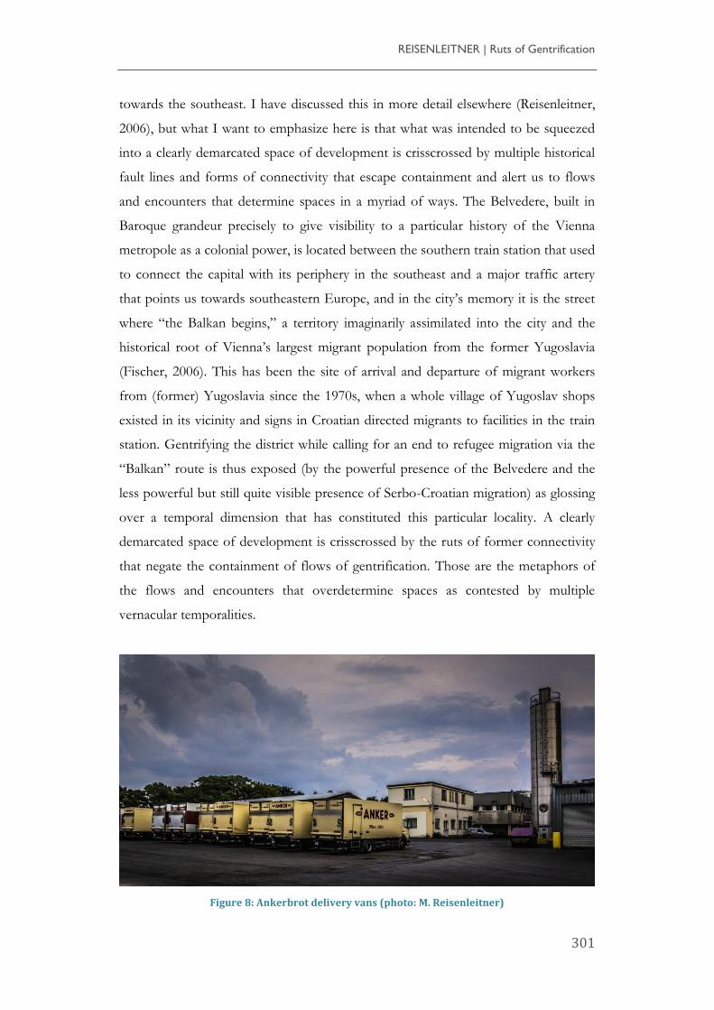
Figure 8: Ankerbrot delivery vans (photo: M. Reisenleitner)
Media Theory
Vol. 2 | No. 1 | 2018 http://mediatheoryjournal.org/
302
Similar vestiges of the ineluctable instability and mobility that characterize any urban
environment can be found at the other sites, even though their ruts are carved in
different ways. The Anker bread factory became prominent through its billboard
advertisements, delivery vans (Figure 8) and its distribution network of up to 270
outlets throughout Vienna that cut across the social and spatial divisions of the city
(“Ankerbrotfabrik – Wien Geschichte Wiki”; see also Kristan and Rapp, 2011),
generating a sense of local pride by claiming that its products were what the Viennese
were looking for most when they returned from holidays. Both outlets and delivery
vans are still a highly visible presence in the city and are often adorned with
historical, clearly nostalgic photographs of the factory’s past presence and movement
within and across the city, rather than the very local yet globally connected imaginary
of Loft City, with its art galleries and media production companies. Through the
constant movement of delivery vans and persistent presence of branded outlets, Loft
City is thus both extended beyond the few blocks of redevelopment and at the same
time scaled back from the transnational aspirations of its architecture and promotion,
folded back, as it were, into the space of Vienna as a remembered, bounded,
historical entity that intersects with the smooth flow of global capital trying to
gentrify a district.
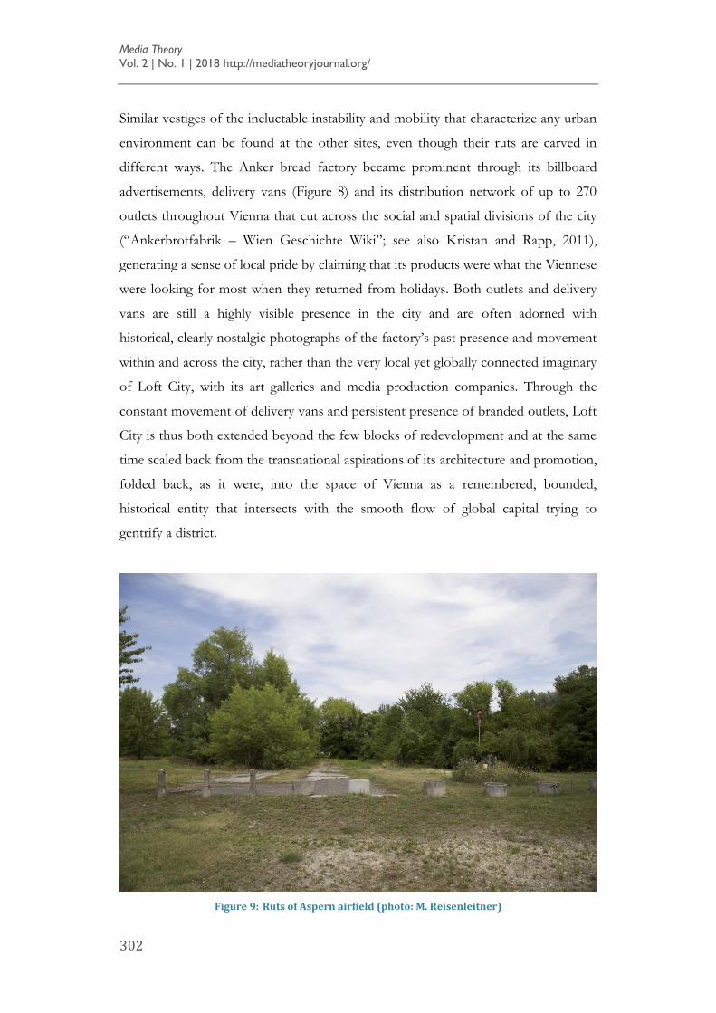
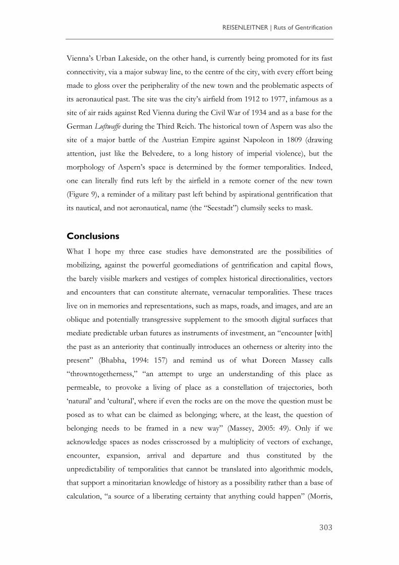
Figure 9: Ruts of Aspern airfield (photo: M. Reisenleitner)
REISENLEITNER | Ruts of Gentrification
303
Vienna’s Urban Lakeside, on the other hand, is currently being promoted for its fast
connectivity, via a major subway line, to the centre of the city, with every effort being
made to gloss over the peripherality of the new town and the problematic aspects of
its aeronautical past. The site was the city’s airfield from 1912 to 1977, infamous as a
site of air raids against Red Vienna during the Civil War of 1934 and as a base for the
German Luftwaffe during the Third Reich. The historical town of Aspern was also the
site of a major battle of the Austrian Empire against Napoleon in 1809 (drawing
attention, just like the Belvedere, to a long history of imperial violence), but the
morphology of Aspern’s space is determined by the former temporalities. Indeed,
one can literally find ruts left by the airfield in a remote corner of the new town
(Figure 9), a reminder of a military past left behind by aspirational gentrification that
its nautical, and not aeronautical, name (the “Seestadt”) clumsily seeks to mask.
Conclusions
What I hope my three case studies have demonstrated are the possibilities of
mobilizing, against the powerful geomediations of gentrification and capital flows,
the barely visible markers and vestiges of complex historical directionalities, vectors
and encounters that can constitute alternate, vernacular temporalities. These traces
live on in memories and representations, such as maps, roads, and images, and are an
oblique and potentially transgressive supplement to the smooth digital surfaces that
mediate predictable urban futures as instruments of investment, an “encounter [with]
the past as an anteriority that continually introduces an otherness or alterity into the
present” (Bhabha, 1994: 157) and remind us of what Doreen Massey calls
“throwntogetherness,” “an attempt to urge an understanding of this place as
permeable, to provoke a living of place as a constellation of trajectories, both
‘natural’ and ‘cultural’, where if even the rocks are on the move the question must be
posed as to what can be claimed as belonging; where, at the least, the question of
belonging needs to be framed in a new way” (Massey, 2005: 49). Only if we
acknowledge spaces as nodes crisscrossed by a multiplicity of vectors of exchange,
encounter, expansion, arrival and departure and thus constituted by the
unpredictability of temporalities that cannot be translated into algorithmic models,
that support a minoritarian knowledge of history as a possibility rather than a base of
calculation, “a source of a liberating certainty that anything could happen” (Morris,
Media Theory
Vol. 2 | No. 1 | 2018 http://mediatheoryjournal.org/
304
1998: 26) can they become meaningful commons, sites of participation and
belonging.
References
“Ankerbrotfabrik – Wien Geschichte Wiki.” Wien.at,
https://www.wien.gv.at/wiki/index.php?title=Ankerbrotfabrik.
Ballhausen, T. et al. (2013) Aspern: Reise in eine mögliche Stadt. Falter Verlag.
Bhabha, H. K. (1994) The Location of Culture. Routledge.
Bönsch, R. (2015) Hauptbahnhof Wien. Vienna Main Station: Die Veränderung eines
Stadtteils. Transformation of an Urban Area 2009-2014. Birkhäuser.
Certeau, M. de. (1984) The Practice of Everyday Life, University of California Press.
Czaja, W. (2017) “Pop-up Dorms Seestadt: Adresse mit Ablaufdatum.” derStandard.
at, 10/04/2017. http://derstandard.at/2000055671384/Pop-up-Dorms-Seestadt-
Adresse-mit-Ablaufdatum.
Deleuze, G., and Guattari, F. (1987) A Thousand Plateaus: Capitalism and Schizophrenia.
University of Minnesota Press.
Fischer, W. (2006) “An Innovative Historiographic Strategy: Representing Migrants
from Southeastern Europe in Vienna” in M. König and R. Ohlinger, ed., Enlarging
European Memory: Migration Movements in Historical Perspective. Thorbecke, pp. 155-
162.
Frantz, D., and Collins, C. (1999) Celebration, U.S.A.: Living in Disney’s Brave New Town.
Henry Holt & Co.
Hantel, M. (2012) “Errant Notes on a Caribbean Rhizome,” Rhizomes 24.
http://www.rhizomes.net/issue24/hantel.html.
Huitner, J. (2015) Imagineering Cultural Vienna, on the Semiotic Regulation of Vienna’s
Culture-Led Urban Transformation. Transcript Verlag.
Jameson, F. (1984) “Postmodernism, or the Cultural Logic of Late Capitalism,” New
Left Review 146, pp. 53–93.
Jordan, S., and Lindner, C. (2016) Cities Interrupted. Visual Culture and Urban Space.
Bloomsbury Publishing Ltd.
Katz, P., et al. (1994). The New Urbanism: Toward an Architecture of Community. McGraw-
Hill.
REISENLEITNER | Ruts of Gentrification
305
Keeling, K. (2007) The Witch’s Flight: The Cinematic, the Black Femme, and the Image of
Common Sense. Duke University Press.
Kristan, M., and Rapp, C. (2011). Ankerbrot - Die Geschichte einer großen Bäckerei.
Brandstätter.
Maderthaner, W., and Musner, L. (2008). Unruly Masses: The Other Side of Fin-de-Siècle
Vienna. Berghahn Books.
Massey, D. (2005). For Space. Sage.
Morris, M. (1998) Too Soon Too Late: History in Popular Culture. Indiana University
Press.
Petschke, K. (2017) The Brick Works: A Posthumanist Mapping. MA Thesis Ryerson.
“Pilotprojekt ohne Pilot.” (2017) Der Standard, May 2017,
https://derstandard.at/2000056978982/Pilotprojekt-ohne-Pilot-Wien-erhaelt-
Linie-mit-fahrerlosem-Bus.
Presner, T., et al. (2014) HyperCities: Thick Mapping in the Digital Humanities. Harvard
University Press.
Rancière, J. (2011) The Emancipated Spectator. Verso.
Reisenleitner, M. (2006) “A Palace with a View: Imagining Europe in the Baroque
City.” spacesofidentity 6/2, pp. 167–184.
---. (2016) “Resetting the Clock: Theme Parks, New Urbanism, and Smart Cities,” in
S. Lukas, ed., A Reader in Themed and Immersive Spaces, Carnegie Mellon ETC Press,
pp. 279–287.
Rosenberger, M. (2014) STEP 2025 Urban Development Plan Vienna. Vienna City
Administration Municipal Department 18, 2014, step.wien.at.
Stadt Wien. Wohnen und Arbeiten an einem Ort - aspern Seestadt.
https://www.wien.gv.at/stadtentwicklung/projekte/aspern-seestadt/wohnen-
arbeiten/index.html.
Tally, R. (2014) Geocritical Explorations: Space, Place, and Mapping in Literary and Cultural
Studies. Palgrave Macmillan.
Townsend, A. (2013) Smart Cities: Big Data, Civic Hackers, and the Quest for a New
Utopia. W. W. Norton & Company.
Westphal, B. (2016) Geocriticism: Real and Fictional Spaces. Palgrave Macmillan.
Westphal, B. (2013) The Plausible World: A Geocritical Approach to Space, Place, and Maps.
Palgrave Macmillan US.
Media Theory
Vol. 2 | No. 1 | 2018 http://mediatheoryjournal.org/
306
Zukin, S. (1987) “Gentrification: Culture and Capital in the Urban Core.” Annual
Review of Sociology 13 (1, 1), pp. 129–47.
Markus Reisenleitner is Professor of Humanities at York University and editor-in-chief of Imaginations: Revue d’études interculturelles de l’image / Journal of Cross-Cultural Image Studies (imaginations.io). His research is situated at the intersections of Cultural Studies, Urban Humanities, Fashion Studies and Digital Humanities. His most recent book is L.A. Chic: A Locational History of Los Angeles Fashion (Intellect; University of Chicago Press, 2018; co-authored with Susan Ingram). He is currently working on a monograph on the countercultural origins of digital media culture. Email: [email protected]